Image-Based Buildings and Facades
|
|
|
- Reynard Shepherd
- 6 years ago
- Views:
Transcription

1 Image-Based Buildings and Facades Peter Wonka Associate Professor of Computer Science Arizona State University Daniel G. Aliaga Associate Professor of Computer Science Purdue University
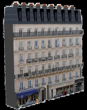
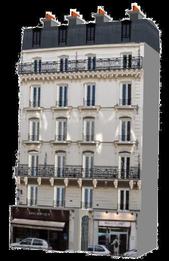
2 Challenge Generate facades/building models starting with images (and maybe some meta-data) Common strategy is to assume specific styles Methods loosely divided into: Non-interactive, and Interactive
3 Non-Interactive Methods Work comes from graphics/vision community Facades: Parsing Image Facades with Reinforcement Learning, O. Teboul, I. Kokkinos, P. Katsourakis, L. Simon, N. Paragios, CVPR 2011 Buildings: 2.5D Dual Contouring: A Robust Approach to Creating Building Models from Aerial LiDAR Point Clouds, Zhou and Neumann, ECCV 2010 Building Reconstruction using Manhattan-World Grammars, C. Vanegas, D. Aliaga, B. Benes, CVPR 2010 Style Grammars for Interactive Visualization of Architecture, D. Aliaga, P. Rosen, D. Bekins, TVCG 2007 (towards interactive )

4 Image-Based Buildings and Facades Parsing Image Facades with Reinforcement Learning Teboul, Kokkinos, Katsourakis, Simon, Paragios CVPR 2011


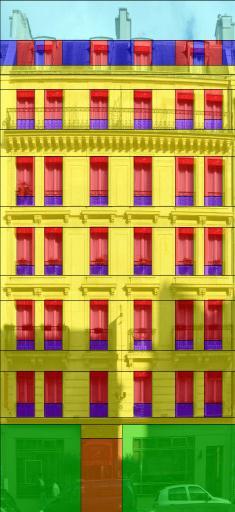
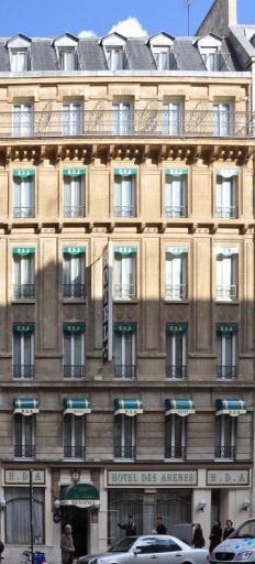
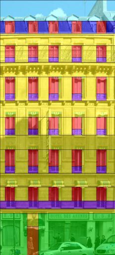
5 Overall Goal I: Semantic Segmentation of Urban Scenes Image Parsing building pedestrian street lamp pavement road cars trees sky shops Cropped/Rectified Building Images: Facade Parsing wall balconnies shop windows sky roof


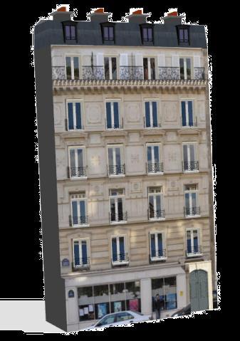

6 Overall Goal II: Image-based Procedural 3D Models Based on 2D parsing + simple extrude and insertion rules turn 2D to 3D


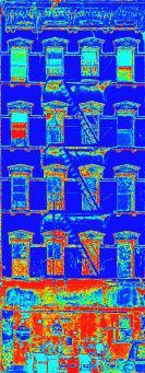
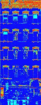
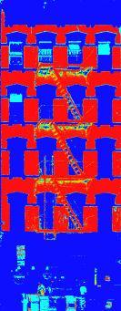
7 Problem Statement Input: image Output: labelling Pixel-level classification function: Objective: Wanted: original m shop m roof m wall m window


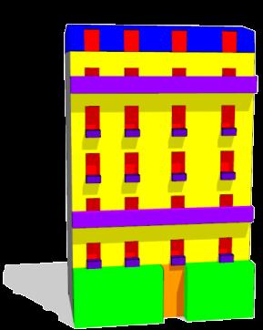
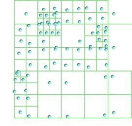
8 Shape Grammars: Recursive Derivation of Labelling Top level: axiom Recursive application of shape operators Partition domain and assign label to each part Terminals: semantic labels (e.g., window, door etc)

9 Binary Split Grammars Binary: N1 a N2 N2 b N1 Split: one dimension at a time


10 Challenges Joint optimization: topology + geometry Enforce the result to be in the language of the grammar: C L(G) High and unknown dimensionality: card L G up to 1 gogol! ( )

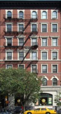
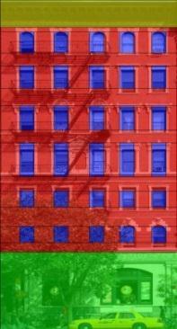
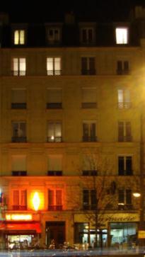
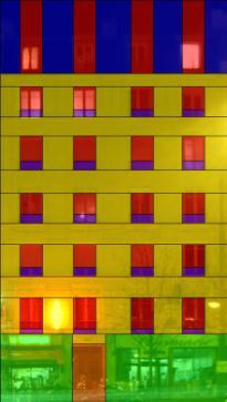
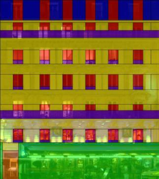

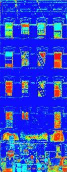
11 Example Results Natural Occlusions Cast Shadows Night Lights

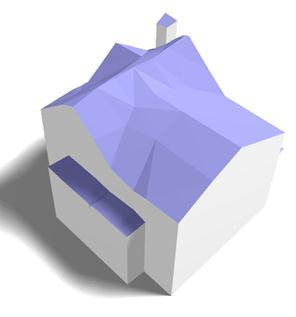
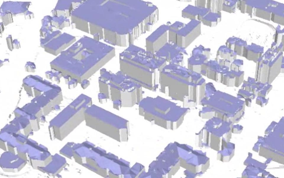
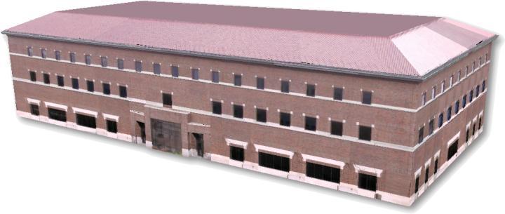
12 Image-Based Buildings and Facades 2.5D Dual Contouring: A Robust Approach to Creating Building Models from Aerial LiDAR Point Clouds Zhou, Neumann ECCV 2010


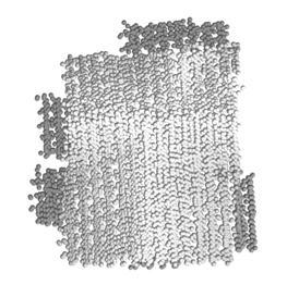
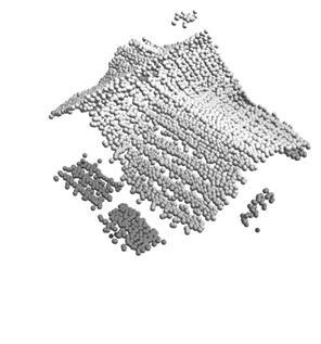
13 2.5D Dual Contouring : A Robust Approach to Creating Building Models from Aerial LiDAR Point Clouds Dense sampling on roofs Detailed building roofs Sparse sampling on vertical walls Vertical walls

![Classic dual contouring [Ju et al 02] Create one 2D](/docs-images/72/67418169/images/14-2.jpg "point per 2D quadtree cell Cons: no 3D output 2.")

![02] [Fiocco et al 05] Create one 3D point per 3D](/docs-images/72/67418169/images/14-4.jpg "octree cell Cons: no 2.")
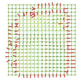
14 2.5D Dual Contouring : A Robust Approach to Creating Building Models from Aerial LiDAR Point Clouds 2D Classic dual contouring [Ju et al 02] Create one 2D point per 2D quadtree cell Cons: no 3D output 2.5D dual contouring Use 2D quadtree as supporting data structure Create one hyperpoint per cell 3D [Ju et al 02] [Fiocco et al 05] Create one 3D point per 3D octree cell Cons: no 2.5D characteristic Different z values Same x-y coordinates


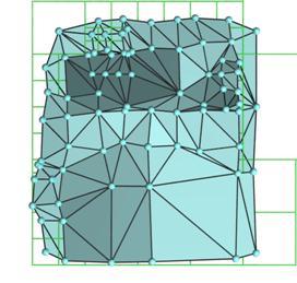
15 Pipeline Input LiDAR data Hermite data Hyper-points Mesh model Final result Scan conversion Polygon generation Optimization Postprocessing
16 Video
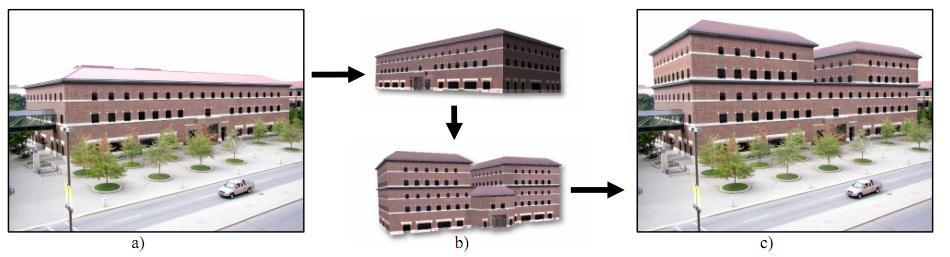
17 Image-Based Buildings and Facades Building Reconstruction using Manhattan- World Grammars Vanegas, Aliaga, Benes CVPR 2010


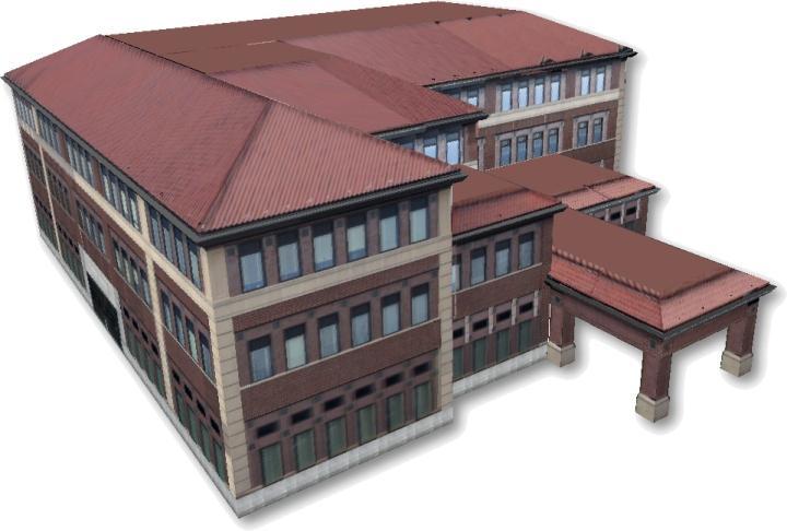
18 Manhattan World Buildings An example of automatic inverse procedural modeling of Manhattan-like buildings


19 Manhattan World Buildings Images of urban areas and street networks all around the world are readily available (e.g., Bing Maps, Google Maps )
")
20 Manhattan World Observation Manhattan World (MW) transitions: 20
21 Manhattan World Observation These three transitions can be represented with just one rule that we call generalized rewriting rule (GRR): 21

22 Our Approach Generate initial 3D building envelope Extrude bounding box of the building footprint extracted from GIS data 22
23 Our Approach Generate initial 3D building envelope Extrude bounding box of the building footprint extracted from GIS data 23


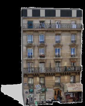
24 Our Approach Generate initial 3D building envelope Divide initial model into a sequence of floors 24


25 Our Approach Generate initial 3D building envelope Divide initial model into a sequence of floors For each floor, automatically modify geometry to match that observed in the images Assume facades have different relative intensities Use the generalized rewriting rule 25

26 Our Approach Example result 26

27 Our Approach Example result 27

28 Our Approach Example result 28

29 Our Approach Example result 29

30 Manhattan World Buildings

31 Image-based Buildings and Facades Style Grammars for Interactive Visualization of Architecture - Aliaga, Rosen, Bekins IEEE TVCG 2007


32 Inspiration: Paint-by-Number Create detailed paintings by filling in numbered regions corresponding to paint colors.


 b) a ) b ) novel")
33 Inspiration: Texture-by-Number Create realistic images using a source photograph and color coding, along with a target color coding. a) b) a ) b ) novel landscape [Hertzmann01]


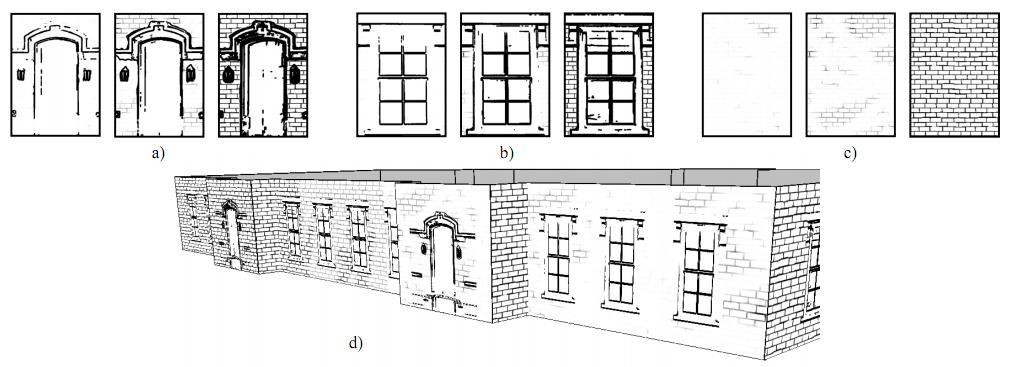
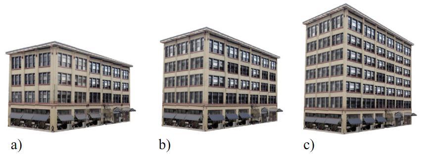
34 This work: Build-by-Number Create realistic architecture using a source image set and model, along with a target model. novel building


35 System Overview 1. A geometric model is recovered from a sparse image set.

36 System Overview 2. The model is subdivided into feature regions such as brick, windows, and doors. Identical or similar features are grouped together.


37 System Overview 3. A face schema, comprising a symbolic growth rule and geometric properties of a single face, is derived and used
38 System Overview 3. A face schema, comprising a symbolic growth rule and geometric properties of a single face, is derived and used F 11 F 12 F 19 F 21 F 22 F 29 F C 1 C 2 C 9 F can be represented symbolically as F = C 1 C 2 C n, where C j = (F 1j F 2j F mj ) is a column of subfaces.

39 System Overview 3. A face schema, comprising a symbolic growth rule and geometric properties of a single face, is derived and used A B C B C B C B A This face is described by the string F = ABCBCBCBA, with possible growth rule F A(BC)*BA

40 System Overview 3. A face schema, comprising a symbolic growth rule and geometric properties of a single face, is derived and used B B 2 B 2 B 2 B 2 1 B 3 B 4 B 1 B 3 B 3 B 3 B 4 B 3 F = ABCBCBCBA F A(BC)*BA F = ABCBCBCBCBCBCBCBCBA


41 System Overview 4. Similarly, a floor schema is derived and used as well captured model model floors

 proper floor 1")
42 System Overview 5. Similarly, a model schema is derived and used as well proper floor 3 proper floor 2 (*) proper floor 1 base floor captured model

43 System Overview 6. Features from the original image set are textured onto the new model with occlusions removed and shading equalized. basic rendering occlusion-free color equalized


 copy and")
44 System Overview 7. A new model is created and automatically subdivided and colored using rules derived from the captured model s subdivision scheme. (new model) copy and paste design in one operation
45 Video
46 Examples
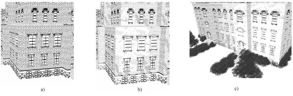
47 Examples
48 Examples
Urban Layouts and Road Networks
 Urban Layouts and Road Networks Daniel G. Aliaga Associate Professor of Computer Science Purdue University Challenge Design and model realistic/plausible road networks and urban layouts Road network: a
Urban Scene Segmentation, Recognition and Remodeling. Part III. Jinglu Wang 11/24/2016 ACCV 2016 TUTORIAL
 Part III Jinglu Wang Urban Scene Segmentation, Recognition and Remodeling 102 Outline Introduction Related work Approaches Conclusion and future work o o - - ) 11/7/16 103 Introduction Motivation Motivation
1/5/2014. Bedrich Benes Purdue University Dec 6 th 2013 Prague. Modeling is an open problem in CG
 Berich Benes Purue University Dec 6 th 213 Prague Inverse Proceural Moeling (IPM) Motivation IPM Classification Case stuies IPM of volumetric builings IPM of stochastic trees Urban reparameterization IPM
1/5/2014. Bedrich Benes Purdue University Dec 12 th 2013 INRIA Imagine. Modeling is an open problem in CG
 Berich Benes Purue University Dec 12 th 213 INRIA Imagine Inverse Proceural Moeling (IPM) Motivation IPM Classification Case stuies IPM of volumetric builings IPM of stochastic trees Urban reparameterization
GRAMMAR SUPPORTED FACADE RECONSTRUCTION FROM MOBILE LIDAR MAPPING
 GRAMMAR SUPPORTED FACADE RECONSTRUCTION FROM MOBILE LIDAR MAPPING Susanne Becker, Norbert Haala Institute for Photogrammetry, University of Stuttgart Geschwister-Scholl-Straße 24D, D-70174 Stuttgart forename.lastname@ifp.uni-stuttgart.de
Façade Reconstruction An Interactive Image-Based Approach
 Façade Reconstruction An Interactive Image-Based Approach Przemyslaw Musialski Institute of Computer Graphics and Algorithms Vienna University of Technology What is Façade Reconstruction? Part of Urban
GRAPHICS TOOLS FOR THE GENERATION OF LARGE SCALE URBAN SCENES
 GRAPHICS TOOLS FOR THE GENERATION OF LARGE SCALE URBAN SCENES Norbert Haala, Martin Kada, Susanne Becker, Jan Böhm, Yahya Alshawabkeh University of Stuttgart, Institute for Photogrammetry, Germany Forename.Lastname@ifp.uni-stuttgart.de
Automatic Generation of 3D Building Models with Efficient Solar Photovoltaic Generation
 International review for spatial planning and sustainable development, Vol.5 No.1 (2017), 4-14 ISSN: 2187-3666 (online) DOI: http://dx.doi.org/10.14246/irspsd.5.1_4 Copyright@SPSD Press from 2010, SPSD
GRAMMAR-BASED AUTOMATIC 3D MODEL RECONSTRUCTION FROM TERRESTRIAL LASER SCANNING DATA
 GRAMMAR-BASED AUTOMATIC 3D MODEL RECONSTRUCTION FROM TERRESTRIAL LASER SCANNING DATA Qian Yu, Petra Helmholz, David Belton and Geoff West Cooperated Research Centre for Spatial Sciences (CRCSI) Department
(Urban) Forward Procedural and Inverse Procedural Modeling
 Forward Procedural and Inverse Procedural Modeling") (Urban) Forward Procedural and Inverse Procedural Modeling www.cs.purdue.edu/cgvlab/urban Daniel Aliaga, CGVLAB Department of Computer Science Purdue University What is the main challenge? Solving the
(Urban) Forward Procedural and Inverse Procedural Modeling www.cs.purdue.edu/cgvlab/urban Daniel Aliaga, CGVLAB Department of Computer Science Purdue University What is the main challenge? Solving the
Volumetric Shape Grammars for Image Segmentation and Shape Estimation
 Volumetric Shape Grammars for Image Segmentation and Shape Estimation Elias Mahfoud emahfoud@uncc.edu Dept. of Computer Science University of North Carolina at Charlotte Charlotte, NC 28223 Andrew Willis
Outline of Presentation. Introduction to Overwatch Geospatial Software Feature Analyst and LIDAR Analyst Software
 Outline of Presentation Automated Feature Extraction from Terrestrial and Airborne LIDAR Presented By: Stuart Blundell Overwatch Geospatial - VLS Ops Co-Author: David W. Opitz Overwatch Geospatial - VLS
Grammar Rule Extraction and Transfer in Buildings
 Grammar Rule Extraction and Transfer in Buildings Asad Khalid Ismail Lahore University of Management Sciences Sector U, DHA, Lahore 13100004@lums.edu.pk Zuha Agha Lahore University of Management Sciences
Texturing Techniques in 3D City Modeling
 Texturing Techniques in 3D City Modeling 1 İdris Kahraman, 2 İsmail Rakıp Karaş, Faculty of Engineering, Department of Computer Engineering, Karabuk University, Turkey 1 idriskahraman@karabuk.edu.tr, 2
Visibility and Occlusion Culling
 Visibility and Occlusion Culling CS535 Fall 2014 Daniel G. Aliaga Department of Computer Science Purdue University [some slides based on those of Benjamin Mora] Why? To avoid processing geometry that does
Cell Decomposition for Building Model Generation at Different Scales
 Cell Decomposition for Building Model Generation at Different Scales Norbert Haala, Susanne Becker, Martin Kada Institute for Photogrammetry Universität Stuttgart Germany forename.lastname@ifp.uni-stuttgart.de
Interactive Design and Visualization of Urban Spaces using Geometrical and Behavioral Modeling
 Interactive Design and Visualization of Urban Spaces using Geometrical and Behavioral Modeling Carlos Vanegas 1,4,5 Daniel Aliaga 1 Bedřich Beneš 2 Paul Waddell 3 1 Computer Science, Purdue University,
Automatic Generation of 3D Building Models for Sustainable Development
 International review for spatial planning and sustainable development, Vol.3 No.2 (2015), 68-78 ISSN: 2187-3666 (online) DOI: http://dx.doi.org/10.14246/irspsd.3.2_68 Copyright@SPSD Press from 2010, SPSD
Urban Grammar. Nate Andrysco Daniel Aliaga Chris Hoffmann
 Urban Grammar Nate Andrysco Daniel Aliaga Chris Hoffmann 1 Urban Visualization Procedural creation of urban layouts for: City planning. Creation of virtual environments for games. Emergency response training.
Introduction to 3D Analysis. Jinwu Ma Jie Chang Khalid Duri
 Introduction to 3D Analysis Jinwu Ma Jie Chang Khalid Duri Area & Volume 3D Analyst Features Detect Change Determine Cut/Fill Calculate Surface Area & Volume Data Management Data Creation Data Conversion
Scene Management. Video Game Technologies 11498: MSc in Computer Science and Engineering 11156: MSc in Game Design and Development
 Video Game Technologies 11498: MSc in Computer Science and Engineering 11156: MSc in Game Design and Development Chap. 5 Scene Management Overview Scene Management vs Rendering This chapter is about rendering
Creating, managing and utilizing a 3D Virtual City in ArcGIS Tamrat Belayneh Eric Wittner
 Creating, managing and utilizing a 3D Virtual City in ArcGIS 10.1 Tamrat Belayneh (tbelayneh@esri.com) Eric Wittner (ewittner@esri.com ) Contents 3D Mapping & Ingredients of a 3D Virtual City Creating
Enhancing photogrammetric 3d city models with procedural modeling techniques for urban planning support
 IOP Conference Series: Earth and Environmental Science OPEN ACCESS Enhancing photogrammetric 3d city models with procedural modeling techniques for urban planning support To cite this article: S Schubiger-Banz
Real-Time Rendering (Echtzeitgraphik) Dr. Michael Wimmer
 Dr. Michael Wimmer") Real-Time Rendering (Echtzeitgraphik) Dr. Michael Wimmer wimmer@cg.tuwien.ac.at Visibility Overview Basics about visibility Basics about occlusion culling View-frustum culling / backface culling Occlusion
Real-Time Rendering (Echtzeitgraphik) Dr. Michael Wimmer wimmer@cg.tuwien.ac.at Visibility Overview Basics about visibility Basics about occlusion culling View-frustum culling / backface culling Occlusion
Manhattan-world Urban Reconstruction from Point Clouds
 Manhattan-world Urban Reconstruction from Point Clouds Minglei Li 1,2, Peter Wonka 1, and Liangliang Nan 1 1 Visual Computing Center, KAUST, Saudi Arabia {mingleili87, liangliang.nan, pwonka}@gmail.com
Automated Processing for 3D Mosaic Generation, a Change of Paradigm
 Automated Processing for 3D Mosaic Generation, a Change of Paradigm Frank BIGNONE, Japan Key Words: 3D Urban Model, Street Imagery, Oblique imagery, Mobile Mapping System, Parallel processing, Digital
2.5D Dual Contouring: A Robust Approach to Creating Building Models from Aerial LiDAR Point Clouds
 2.5D Dual Contouring: A Robust Approach to Creating Building Models from Aerial LiDAR Point Clouds Qian-Yi Zhou and Ulrich Neumann University of Southern California Abstract. We present a robust approach
Automated Super-Voxel Based Features Classification of Urban Environments by Integrating 3D Point Cloud and Image Content
 Automated Super-Voxel Based Features Classification of Urban Environments by Integrating 3D Point Cloud and Image Content Pouria Babahajiani #1, Lixin Fan *2, Joni Kamarainen #3, Moncef Gabbouj #4 # Department
Computer Graphics. Bing-Yu Chen National Taiwan University The University of Tokyo
 Computer Graphics Bing-Yu Chen National Taiwan University The University of Tokyo Hidden-Surface Removal Back-Face Culling The Depth-Sort Algorithm Binary Space-Partitioning Trees The z-buffer Algorithm
Computer Graphics. Bing-Yu Chen National Taiwan University
 Computer Graphics Bing-Yu Chen National Taiwan University Visible-Surface Determination Back-Face Culling The Depth-Sort Algorithm Binary Space-Partitioning Trees The z-buffer Algorithm Scan-Line Algorithm
MODELING AND HIERARCHY
 MODELING AND HIERARCHY Introduction Models are abstractions of the world both of the real world in which we live and of virtual worlds that we create with computers. We are all familiar with mathematical
Identifying those parts of a scene that are visible from a chosen viewing position, and only process (scan convert) those parts
 those parts") Visible Surface Detection Identifying those parts of a scene that are visible from a chosen viewing position, and only process (scan convert) those parts Two approaches: 1. Object space methods 2. Image
Visible Surface Detection Identifying those parts of a scene that are visible from a chosen viewing position, and only process (scan convert) those parts Two approaches: 1. Object space methods 2. Image
CHAPTER 1 Graphics Systems and Models 3
 ?????? 1 CHAPTER 1 Graphics Systems and Models 3 1.1 Applications of Computer Graphics 4 1.1.1 Display of Information............. 4 1.1.2 Design.................... 5 1.1.3 Simulation and Animation...........
COMP 175: Computer Graphics April 11, 2018
 Lecture n+1: Recursive Ray Tracer2: Advanced Techniques and Data Structures COMP 175: Computer Graphics April 11, 2018 1/49 Review } Ray Intersect (Assignment 4): questions / comments? } Review of Recursive
AUTOMATIC RECONSTRUCTION OF LARGE-SCALE VIRTUAL ENVIRONMENT FOR INTELLIGENT TRANSPORTATION SYSTEMS SIMULATION
 AUTOMATIC RECONSTRUCTION OF LARGE-SCALE VIRTUAL ENVIRONMENT FOR INTELLIGENT TRANSPORTATION SYSTEMS SIMULATION Khairil Azmi, Shintaro Ono, Masataka Kagesawa, Katsushi Ikeuchi Institute of Industrial Science,
CS535 Fall Department of Computer Science Purdue University
 Culling CS535 Fall 2010 Daniel G Aliaga Daniel G. Aliaga Department of Computer Science Purdue University Types of culling View frustum culling Visibility culling e.g., backface culling, portal tlculling,
Geometric Modeling. Bing-Yu Chen National Taiwan University The University of Tokyo
 Geometric Modeling Bing-Yu Chen National Taiwan University The University of Tokyo What are 3D Objects? 3D Object Representations What are 3D objects? The Graphics Process 3D Object Representations Raw
CELL DECOMPOSITION FOR THE GENERATION OF BUILDING MODELS AT MULTIPLE SCALES
 CELL DECOMPOSITION FOR THE GENERATION OF BUILDING MODELS AT MULTIPLE SCALES Norbert Haala, Susanne Becker, Martin Kada Institute for Photogrammetry, Universitaet Stuttgart Geschwister-Scholl-Str. 24D,
Z-Buffer hold pixel's distance from camera. Z buffer
 Z-Buffer hold pixel's distance from camera Z buffer Frustrum Culling and Z-buffering insufficient Given a large enough set of polygons, no matter how fast the graphics card, sending it too many hidden
Global Rendering. Ingela Nyström 1. Effects needed for realism. The Rendering Equation. Local vs global rendering. Light-material interaction
 Effects needed for realism Global Rendering Computer Graphics 1, Fall 2005 Lecture 7 4th ed.: Ch 6.10, 12.1-12.5 Shadows Reflections (Mirrors) Transparency Interreflections Detail (Textures etc.) Complex
Automatic generation of 3-d building models from multiple bounded polygons
 icccbe 2010 Nottingham University Press Proceedings of the International Conference on Computing in Civil and Building Engineering W Tizani (Editor) Automatic generation of 3-d building models from multiple
Permanent Structure Detection in Cluttered Point Clouds from Indoor Mobile Laser Scanners (IMLS)
") Permanent Structure Detection in Cluttered Point Clouds from NCG Symposium October 2016 Promoter: Prof. Dr. Ir. George Vosselman Supervisor: Michael Peter Problem and Motivation: Permanent structure reconstruction,
Permanent Structure Detection in Cluttered Point Clouds from NCG Symposium October 2016 Promoter: Prof. Dr. Ir. George Vosselman Supervisor: Michael Peter Problem and Motivation: Permanent structure reconstruction,
Geometric Representations. Stelian Coros
 Geometric Representations Stelian Coros Geometric Representations Languages for describing shape Boundary representations Polygonal meshes Subdivision surfaces Implicit surfaces Volumetric models Parametric
Semi-Automatic Techniques for Generating BIM Façade Models of Historic Buildings
 Semi-Automatic Techniques for Generating BIM Façade Models of Historic Buildings C. Dore, M. Murphy School of Surveying & Construction Management Dublin Institute of Technology Bolton Street Campus, Dublin
CEng 477 Introduction to Computer Graphics Fall 2007
 Visible Surface Detection CEng 477 Introduction to Computer Graphics Fall 2007 Visible Surface Detection Visible surface detection or hidden surface removal. Realistic scenes: closer objects occludes the
Convergent Modeling and Reverse Engineering
 Convergent Modeling and Reverse Engineering 25 October 2017 Realize innovation. Tod Parrella NX Design Product Management Product Engineering Solutions tod.parrella@siemens.com Realize innovation. Siemens
Level of Details in Computer Rendering
 Level of Details in Computer Rendering Ariel Shamir Overview 1. Photo realism vs. Non photo realism (NPR) 2. Objects representations 3. Level of details Photo Realism Vs. Non Pixar Demonstrations Sketching,
Multi-view stereo. Many slides adapted from S. Seitz
 Multi-view stereo Many slides adapted from S. Seitz Beyond two-view stereo The third eye can be used for verification Multiple-baseline stereo Pick a reference image, and slide the corresponding window
Advanced point cloud processing
 Advanced point cloud processing George Vosselman ITC Enschede, the Netherlands INTERNATIONAL INSTITUTE FOR GEO-INFORMATION SCIENCE AND EARTH OBSERVATION Laser scanning platforms Airborne systems mounted
Towards Complete LOD3 Models Automatic Interpretation of Building Structures
 Photogrammetric Week '11 Dieter Fritsch (Ed.) Wichmann/VDE Verlag, Belin & Offenbach, 2011 Becker 39 Towards Complete LOD3 Models Automatic Interpretation of Building Structures SUSANNE BECKER, Stuttgart
CS 352: Computer Graphics. Hierarchical Graphics, Modeling, And Animation
 CS 352: Computer Graphics Hierarchical Graphics, Modeling, And Animation Chapter 9-2 Overview Modeling Animation Data structures for interactive graphics CSG-tree BSP-tree Quadtrees and Octrees Visibility
Complete Residential Urban Area Reconstruction from Dense Aerial LiDAR Point Clouds
 Complete Residential Urban Area Reconstruction from Dense Aerial LiDAR Point Clouds Qian-Yi Zhou, Ulrich Neumann University of Southern California Abstract We present an automatic system to reconstruct
Shape modeling Modeling technique Shape representation! 3D Graphics Modeling Techniques
 D Graphics http://chamilo2.grenet.fr/inp/courses/ensimag4mmgd6/ Shape Modeling technique Shape representation! Part : Basic techniques. Projective rendering pipeline 2. Procedural Modeling techniques Shape
Spatial Data Structures and Speed-Up Techniques. Tomas Akenine-Möller Department of Computer Engineering Chalmers University of Technology
 Spatial Data Structures and Speed-Up Techniques Tomas Akenine-Möller Department of Computer Engineering Chalmers University of Technology Spatial data structures What is it? Data structure that organizes
Page 1. Area-Subdivision Algorithms z-buffer Algorithm List Priority Algorithms BSP (Binary Space Partitioning Tree) Scan-line Algorithms
 Scan-line Algorithms") Visible Surface Determination Visibility Culling Area-Subdivision Algorithms z-buffer Algorithm List Priority Algorithms BSP (Binary Space Partitioning Tree) Scan-line Algorithms Divide-and-conquer strategy:
Visible Surface Determination Visibility Culling Area-Subdivision Algorithms z-buffer Algorithm List Priority Algorithms BSP (Binary Space Partitioning Tree) Scan-line Algorithms Divide-and-conquer strategy:
INDOOR 3D MODEL RECONSTRUCTION TO SUPPORT DISASTER MANAGEMENT IN LARGE BUILDINGS Project Abbreviated Title: SIMs3D (Smart Indoor Models in 3D)
") INDOOR 3D MODEL RECONSTRUCTION TO SUPPORT DISASTER MANAGEMENT IN LARGE BUILDINGS Project Abbreviated Title: SIMs3D (Smart Indoor Models in 3D) PhD Research Proposal 2015-2016 Promoter: Prof. Dr. Ir. George
INDOOR 3D MODEL RECONSTRUCTION TO SUPPORT DISASTER MANAGEMENT IN LARGE BUILDINGS Project Abbreviated Title: SIMs3D (Smart Indoor Models in 3D) PhD Research Proposal 2015-2016 Promoter: Prof. Dr. Ir. George
What is Computer Vision? Introduction. We all make mistakes. Why is this hard? What was happening. What do you see? Intro Computer Vision
 What is Computer Vision? Trucco and Verri (Text): Computing properties of the 3-D world from one or more digital images Introduction Introduction to Computer Vision CSE 152 Lecture 1 Sockman and Shapiro:
Graphics and Interaction Rendering pipeline & object modelling
 433-324 Graphics and Interaction Rendering pipeline & object modelling Department of Computer Science and Software Engineering The Lecture outline Introduction to Modelling Polygonal geometry The rendering
NATIONWIDE POINT CLOUDS AND 3D GEO- INFORMATION: CREATION AND MAINTENANCE GEORGE VOSSELMAN
 NATIONWIDE POINT CLOUDS AND 3D GEO- INFORMATION: CREATION AND MAINTENANCE GEORGE VOSSELMAN OVERVIEW National point clouds Airborne laser scanning in the Netherlands Quality control Developments in lidar
Hybrid Rendering for Collaborative, Immersive Virtual Environments
 Hybrid Rendering for Collaborative, Immersive Virtual Environments Stephan Würmlin wuermlin@inf.ethz.ch Outline! Rendering techniques GBR, IBR and HR! From images to models! Novel view generation! Putting
SIMPLE ROOM SHAPE MODELING WITH SPARSE 3D POINT INFORMATION USING PHOTOGRAMMETRY AND APPLICATION SOFTWARE
 SIMPLE ROOM SHAPE MODELING WITH SPARSE 3D POINT INFORMATION USING PHOTOGRAMMETRY AND APPLICATION SOFTWARE S. Hirose R&D Center, TOPCON CORPORATION, 75-1, Hasunuma-cho, Itabashi-ku, Tokyo, Japan Commission
Lecture 12: Advanced Rendering
 Lecture 12: Advanced Rendering CSE 40166 Computer Graphics Peter Bui University of Notre Dame, IN, USA November 30, 2010 Limitations of OpenGL Pipeline Rendering Good Fast, real-time graphics rendering.
CSE528 Computer Graphics: Theory, Algorithms, and Applications
 CSE528 Computer Graphics: Theory, Algorithms, and Applications Hong Qin State University of New York at Stony Brook (Stony Brook University) Stony Brook, New York 11794--4400 Tel: (631)632-8450; Fax: (631)632-8334
9. Three Dimensional Object Representations
 9. Three Dimensional Object Representations Methods: Polygon and Quadric surfaces: For simple Euclidean objects Spline surfaces and construction: For curved surfaces Procedural methods: Eg. Fractals, Particle
Region-based Segmentation and Object Detection
 Region-based Segmentation and Object Detection Stephen Gould Tianshi Gao Daphne Koller Presented at NIPS 2009 Discussion and Slides by Eric Wang April 23, 2010 Outline Introduction Model Overview Model
Semantic Segmentation of Street-Side Images
 Semantic Segmentation of Street-Side Images Michal Recky 1, Franz Leberl 2 1 Institute for Computer Graphics and Vision Graz University of Technology recky@icg.tugraz.at 2 Institute for Computer Graphics
Ray Tracing. CS334 Fall Daniel G. Aliaga Department of Computer Science Purdue University
 Ray Tracing CS334 Fall 2013 Daniel G. Aliaga Department of Computer Science Purdue University Ray Casting and Ray Tracing Ray Casting Arthur Appel, started around 1968 Ray Tracing Turner Whitted, started
PERFORMANCE CAPTURE FROM SPARSE MULTI-VIEW VIDEO
 Stefan Krauß, Juliane Hüttl SE, SoSe 2011, HU-Berlin PERFORMANCE CAPTURE FROM SPARSE MULTI-VIEW VIDEO 1 Uses of Motion/Performance Capture movies games, virtual environments biomechanics, sports science,
OVERVIEW OF BUILDING RESEARCH AT THE APPLIED GEOTECHNOLOGIES
 PhD and Postdoc research OVERVIEW OF BUILDING RESEARCH AT THE APPLIED GEOTECHNOLOGIES Lucía Díaz Vilariño Delft, December 2016 Index The Applied Geotechnologies Research Group PhD research: from point
FAST PRODUCTION OF VIRTUAL REALITY CITY MODELS
 FAST PRODUCTION OF VIRTUAL REALITY CITY MODELS Claus Brenner and Norbert Haala Institute for Photogrammetry (ifp) University of Stuttgart Geschwister-Scholl-Straße 24, 70174 Stuttgart, Germany Ph.: +49-711-121-4097,
High Definition Modeling of Calw, Badstrasse and its Google Earth Integration
 Master Thesis Yuanting LI High Definition Modeling of Calw, Badstrasse and its Google Earth Integration Duration of the Thesis: 6 months Completion: July, 2014 Supervisors: Prof.Dr.-Ing.Dieter Fritsch
3D CITY MODELLING WITH CYBERCITY-MODELER
 1 3D CITY MODELLING WITH CYBERCITY-MODELER Kilian Ulm 1 and Daniela Poli 1 1. CyberCity AG, Zurich, Switzerland, (kilian.ulm, daniela.poli)@cybercity.tv ABSTRACT 3D city models using stereo aerial-/satellite
BUILDING RECONSTRUCTION USING LIDAR DATA
 BUILDING RECONSTRUCTION USING LIDAR DATA R. O.C. Tse, M. Dakowicz, C.M. Gold, and D.B. Kidner GIS Research Centre, School of Computing, University of Glamorgan, Pontypridd, CF37 1DL, Wales, UK. rtse@glam.ac.uk,mdakowic@glam.ac.uk,cmgold@glam.ac.uk,
ELL 788 Computational Perception & Cognition July November 2015
 ELL 788 Computational Perception & Cognition July November 2015 Module 6 Role of context in object detection Objects and cognition Ambiguous objects Unfavorable viewing condition Context helps in object
A Vrml97-X3D Extension for Massive Scenery Management in Virtual Worlds
 A Vrml97-X3D Extension for Massive Scenery Management in Virtual Worlds Jean-Eudes Marvie INSA of Rennes Kadi Bouatouch University of Rennes Abstract In this paper we present a VRML97-X3D extension to
TcpMDT. Digital Terrain Model Version 7.5. TcpMDT
 Digital Terrain Model Version 7.5 Versions and Modules PROFESSIONAL STANDARD IMAGES SURVEYING POINT CLOUD Product Features STANDARD Surveying Points Management Digital Terrain Model Contours Terrain Cross
Synscapes A photorealistic syntehtic dataset for street scene parsing Jonas Unger Department of Science and Technology Linköpings Universitet.
 Synscapes A photorealistic syntehtic dataset for street scene parsing Jonas Unger Department of Science and Technology Linköpings Universitet 7D Labs VINNOVA https://7dlabs.com Photo-realistic image synthesis
A SYNTAX FOR IMAGE UNDERSTANDING
 A SYNTAX FOR IMAGE UNDERSTANDING Narendra Ahuja University of Illinois at Urbana-Champaign May 21, 2009 Work Done with. Sinisa Todorovic, Mark Tabb, Himanshu Arora, Varsha. Hedau, Bernard Ghanem, Tim Cheng.
CS 488. More Shading and Illumination. Luc RENAMBOT
 CS 488 More Shading and Illumination Luc RENAMBOT 1 Illumination No Lighting Ambient model Light sources Diffuse reflection Specular reflection Model: ambient + specular + diffuse Shading: flat, gouraud,
Semantic Parsing of Street Scene Images Using 3D LiDAR Point Cloud
 2013 IEEE International Conference on Computer Vision Workshops Semantic Parsing of Street Scene Images Using 3D LiDAR Point Cloud Pouria Babahajiani Tampere University of Technology Tampere, Finland pouria.babahajiani@tut.fi
DIGITAL SURFACE MODELS OF CITY AREAS BY VERY HIGH RESOLUTION SPACE IMAGERY
 DIGITAL SURFACE MODELS OF CITY AREAS BY VERY HIGH RESOLUTION SPACE IMAGERY Jacobsen, K. University of Hannover, Institute of Photogrammetry and Geoinformation, Nienburger Str.1, D30167 Hannover phone +49
Light Transport CS434. Daniel G. Aliaga Department of Computer Science Purdue University
 Light Transport CS434 Daniel G. Aliaga Department of Computer Science Purdue University Topics Local and Global Illumination Models Helmholtz Reciprocity Dual Photography/Light Transport (in Real-World)
Topic 12: Texture Mapping. Motivation Sources of texture Texture coordinates Bump mapping, mip-mapping & env mapping
 Topic 12: Texture Mapping Motivation Sources of texture Texture coordinates Bump mapping, mip-mapping & env mapping Texture sources: Photographs Texture sources: Procedural Texture sources: Solid textures
A Heightmap Model for Efficient 3D Reconstruction from Street-Level Video
 A Heightmap Model for Efficient 3D Reconstruction from Street-Level Video David Gallup 1, Jan-Michael Frahm 1 1 University of North Carolina Department of Computer Science {gallup,jmf}@cs.unc.edu Marc
Colorado School of Mines. Computer Vision. Professor William Hoff Dept of Electrical Engineering &Computer Science.
 Professor William Hoff Dept of Electrical Engineering &Computer Science http://inside.mines.edu/~whoff/ 1 Introduction to 2 What is? A process that produces from images of the external world a description
Topic 11: Texture Mapping 11/13/2017. Texture sources: Solid textures. Texture sources: Synthesized
 Topic 11: Texture Mapping Motivation Sources of texture Texture coordinates Bump mapping, mip mapping & env mapping Texture sources: Photographs Texture sources: Procedural Texture sources: Solid textures
Ray Tracing III. Wen-Chieh (Steve) Lin National Chiao-Tung University
 Lin National Chiao-Tung University") Ray Tracing III Wen-Chieh (Steve) Lin National Chiao-Tung University Shirley, Fundamentals of Computer Graphics, Chap 10 Doug James CG slides, I-Chen Lin s CG slides Ray-tracing Review For each pixel,
Ray Tracing III Wen-Chieh (Steve) Lin National Chiao-Tung University Shirley, Fundamentals of Computer Graphics, Chap 10 Doug James CG slides, I-Chen Lin s CG slides Ray-tracing Review For each pixel,
Lighting. To do. Course Outline. This Lecture. Continue to work on ray programming assignment Start thinking about final project
 To do Continue to work on ray programming assignment Start thinking about final project Lighting Course Outline 3D Graphics Pipeline Modeling (Creating 3D Geometry) Mesh; modeling; sampling; Interaction
Point based global illumination is now a standard tool for film quality renderers. Since it started out as a real time technique it is only natural
 1 Point based global illumination is now a standard tool for film quality renderers. Since it started out as a real time technique it is only natural to consider using it in video games too. 2 I hope that
Computer Graphics. Lecture 13. Global Illumination 1: Ray Tracing and Radiosity. Taku Komura
 Computer Graphics Lecture 13 Global Illumination 1: Ray Tracing and Radiosity Taku Komura 1 Rendering techniques Can be classified as Local Illumination techniques Global Illumination techniques Local
Programmable Graphics Processing Units for Urban Landscape Visualization
 Programmable Graphics Processing Units for Urban Landscape Visualization M. Kada, T. Balz, N. Haala, D. Fritsch Institute for Photogrammetry, Universität Stuttgart, Germany ABSTRACT: The availability of
Data Acquisition, Leica Scan Station 2, Park Avenue and 70 th Street, NY
 Automated registration of 3D-range with 2D-color images: an overview 44 th Annual Conference on Information Sciences and Systems Invited Session: 3D Data Acquisition and Analysis March 19 th 2010 Ioannis
3D Shape Analysis with Multi-view Convolutional Networks. Evangelos Kalogerakis
 3D Shape Analysis with Multi-view Convolutional Networks Evangelos Kalogerakis 3D model repositories [3D Warehouse - video] 3D geometry acquisition [KinectFusion - video] 3D shapes come in various flavors
LASERDATA LIS build your own bundle! LIS Pro 3D LIS 3.0 NEW! BETA AVAILABLE! LIS Road Modeller. LIS Orientation. LIS Geology.
 LIS 3.0...build your own bundle! NEW! LIS Geology LIS Terrain Analysis LIS Forestry LIS Orientation BETA AVAILABLE! LIS Road Modeller LIS Editor LIS City Modeller colors visualization I / O tools arithmetic
Topic 11: Texture Mapping 10/21/2015. Photographs. Solid textures. Procedural
 Topic 11: Texture Mapping Motivation Sources of texture Texture coordinates Bump mapping, mip mapping & env mapping Topic 11: Photographs Texture Mapping Motivation Sources of texture Texture coordinates
Automated Extraction of Buildings from Aerial LiDAR Point Cloud and Digital Imaging Datasets for 3D Cadastre - Preliminary Results
 Automated Extraction of Buildings from Aerial LiDAR Point Cloud and Digital Imaging Datasets for 3D Pankaj Kumar 1*, Alias Abdul Rahman 1 and Gurcan Buyuksalih 2 ¹Department of Geoinformation Universiti
BUILDING MODEL RECONSTRUCTION FROM DATA INTEGRATION INTRODUCTION
 BUILDING MODEL RECONSTRUCTION FROM DATA INTEGRATION Ruijin Ma Department Of Civil Engineering Technology SUNY-Alfred Alfred, NY 14802 mar@alfredstate.edu ABSTRACT Building model reconstruction has been
Mobile Mapping and Navigation. Brad Kohlmeyer NAVTEQ Research
 Mobile Mapping and Navigation Brad Kohlmeyer NAVTEQ Research Mobile Mapping & Navigation Markets Automotive Enterprise Internet & Wireless Mobile Devices 2 Local Knowledge & Presence Used to Create Most
SHAPE GRAMMARS procedural generation techniques for virtual cities
 SHAPE GRAMMARS procedural generation techniques for virtual cities Sebastien Parodi (source) University of Pennsylvania - CIS 700 Procedural Graphics Rachel Hwang URBAN ENVIRONMENTS High demand for city
Subdivision Of Triangular Terrain Mesh Breckon, Chenney, Hobbs, Hoppe, Watts
 Subdivision Of Triangular Terrain Mesh Breckon, Chenney, Hobbs, Hoppe, Watts MSc Computer Games and Entertainment Maths & Graphics II 2013 Lecturer(s): FFL (with Gareth Edwards) Fractal Terrain Based on