Web Map Caching and Tiling. Overview David M. Horwood June 2011
|
|
|
- Hubert Fisher
- 6 years ago
- Views:
Transcription
1 Web Map Caching and Tiling Overview David M. Horwood June 2011
2 Web Mapping Traditional Geographic projection Select / Refresh workflow Slow, non-interactive (refresh delay) Modern AJAX (Asynchronous Java and XML) Stream pre-rendered tiles to browser Browser caches tiles, no need to resend More interactive map (dynamic pan and zoom)
3 Traditional Map

4 Modern Map
5 Web Map Caching Popularized by Google and adopted by Microsoft and ESRI (and others) Divides the world into tiles starting with 4 tiles and successively divides the world Stores tiles relative to Web Mercator Starts at level of detail (LOD) 1 and recursively subdivides each tile into 4 parts

6 Web Mercator Spherical projection Maps WGS84 LL as spherical LL Scale increases with distance from equator Scale asymptotic at poles Replicated east and west in window for seamless pan

7 Level of Detail World is divided successively into tiles Indexed by quadtree code LOD by convention defined down to level 23 (approx 2cm)
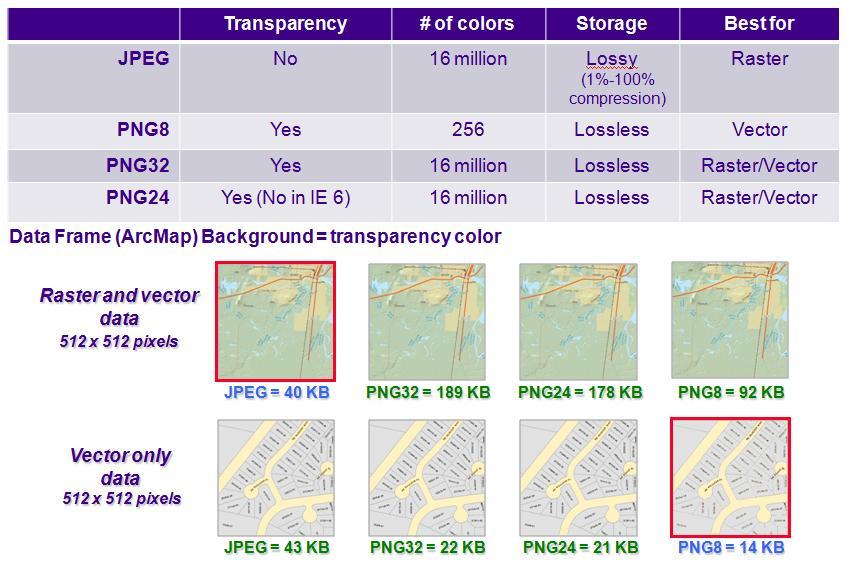
8 Tile Size 256 x 256 pixels = 192KB RGB Tiles normally stored as JPG or PNG JPG for raster imagery PNG for rendered vector Compressed size ~ 40KB JPG fairly consistent, PNG can be variable Average display 1024 x x 3 = 12 tiles = 480KB 5 x 4 = 20 tiles including overlap = 800KB
9 Tiles
10 Level of Detail and Sizes 1 Tile = 40 KB 0.1 s LOD Scale Pixel Tiles Size Source Time 1 295,829,355 : KB 0.4 s 2 147,914,678 : KB 1.6 s 3 73,957,339 : MB 6.4 s 4 36,978,669 : MB 25.6 s 5 18,489,335 : MB 1.7 m 6 9,244,667 : MB 6.8 m 7 4,622,334 : MB 27.3 m 8 2,311,167 : GB 1.8 h 9 1,155,583 : GB 7.3 h ,792 : GB 1.2 D ,896 : GB 4.9 D ,448 : GB 19.4 D 13 72,224 : TB Landsat 2.6 M 14 36,112 : TB 10.4 M 15 18,056 : E TB 3.5 Y 16 9,028 : E TB 13.8 Y 17 4,514 : E TB 55.2 Y 18 2,257 : E PB Satellite Y 19 1,128 : E PB Aerial Y : E PB Aerial 3,535.0 Y : E PB 14,139.8 Y : E PB 56,559.2 Y : E EB 226,237.0 Y
11 Cache Size Estimate 1 Tile = 40 KB 0.1 s Coverage Area (km²) Pixel Tiles Size Source Time Web Mercator 1,606,006, GB 1.2 D Earth 510,000, GB 9.2 h Land (30%) 153,000, GB Landsat 7.4 D Urban (1.5%) 2,295, TB Satellite 3.8 M
12 Cache Creation 1. Project data into target projection 2. Render data at each of the target scales 3. Store raster tiles (JPG/PNG)
13 Cache Display 1. User requests area and level of detail 2. Server sends the appropriate tiles at LOD 3. Browser displays and retains the tiles 4. As user zooms or pans, server sends new tiles as required 5. Browser handles redisplay and shifting of tiles
14 Cache Benefits No projection required for display Simple spherical equations to convert xy to LL (and for approximate distance / area) North is always north Adopted by Google, Microsoft, ESRI (and others) Existing rendered geographic context
15 Cache Problems Increase in scale from equator Develop must correct Cartesian meaurements Asymptotic at the poles Unusable > 84 N/S Must use Google approach / formulas WGS84 LL used as spherical LL Must project if non-mercator map

16 Cache Problems (in Canada) Cache increases dramatically north of 60 N 45 N => 1.4x 60 N => 2.0x 75 N => 3.9x 84 N => 9.6x Caching to same level increases cache size over 3x
17 Challenges to Improvement Current caching model solves two problems with a single solution Storage Display Any more complex system needs to insert computation either at the server or the client or both Leverage existing rendered caches
18 Middle Ground Dynamic Projection (AGS, others) GEOIDE Project Target (professional) Simple Web Map (Google, Bing, ESRI, others) Whole Earth (Google, Bing, ESRI, NASA)
19 Alternatives You cannot flatten the whole earth Either cut into pieces (i.e., not seamless) View in 3D (hides one half of the earth) Options Hybrid projection (e.g., conic + cylindrical) Unfolding projection Orthographic projection of ECEF 3D virtual environment


20 Dymaxion Map Low distortion unfolding projection Could be used in conjunction with hierarchical triangular mesh
21 Earth Centered Earth Fixed (ECEF) Coordinates actually calculated by GPS Can be used as a basis for whole earth

22 Hierarchical Triangular Mesh Can serve as both tile and index ECEF centroid is normal
23 Orthographic Projection Simple linear transformation Rotate to ECEF centre and eliminate Z Could be optimized Transform tiles on-the-fly during display Use 3D rendering API (DirectX, OpenGL) Distorts as display approaches hemisphere
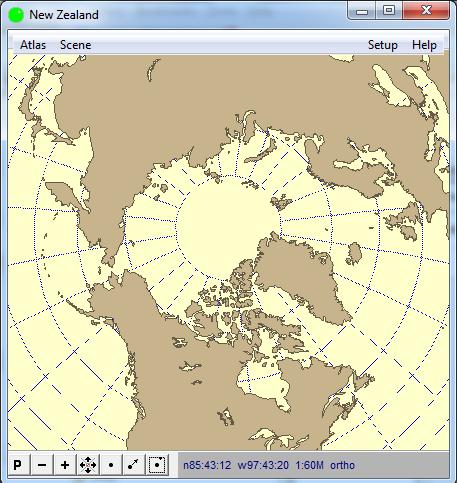
24 Orthographic Projection
25 Properties of Ideal Solution Whole earth Seamless Minimize distortion Measure distance and area Efficient storage and retrieval Multi-resolution Dynamic pan North up Mobile and Desktop (Browser) Javascript, Flex, Silverlight APIs
26 Questions?
Well Unknown ID AKA EPSG: 3857
 Well Unknown ID AKA EPSG: 3857 Pamela Kanu November 2016 WGS 1984 WEB MERCATOR ALIASES: AUXILIARY SPHERE, WKID: 3857, WKID: 102100, WKID: 102113, SHERICAL MERCATOR, WGS 84/PSEUDO-MERCATOR, OPEN LAYERS:
Activity 1.1.1: Using Google Earth to View the World
 Learning Objectives Upon completion of this activity, you will be able to: Explain the purpose of Google Earth. Explain the different versions of Google Earth. Explain the hardware and software requirements
Tileset Concepts and Terminology
 Tileset Concepts and Terminology Bing Maps Your Geodata raster Bing Maps vector shape CAD Google Maps Google Maps NASA World Wind Google Earth Google Earth MicroImages, Inc. 11th Floor - Sharp Tower 206
What should y you expect in this session? Basic to advanced topics Outline What is map caching? Why should I cache? Caching workflow How to create a c
 Designing, Deploying, and Using Cached Map Services David Crosby & Craig Mesimer What should y you expect in this session? Basic to advanced topics Outline What is map caching? Why should I cache? Caching
Building Basemaps: MapCaches and VectorTiles. Matthias Schenker Gerhard Trichtl
 Building Basemaps: MapCaches and VectorTiles Matthias Schenker Gerhard Trichtl What are Basemaps for Basemaps provide a optimal background and orientation for displaying your data on top Should be - Fast
Managing Image Data on the ArcGIS Platform Options and Recommended Approaches
 Managing Image Data on the ArcGIS Platform Options and Recommended Approaches Peter Becker Petroleum requirements for imagery and raster Traditional solutions and issues Overview of ArcGIS imaging capabilities
Getting Started with ArcGIS for Server. Charmel Menzel and Ken Gorton
 Getting Started with ArcGIS for Server Charmel Menzel and Ken Gorton Agenda What is ArcGIS for Server? Types of Web services Publishing resources onto the Web Clients to ArcGIS for Server Editions and
Designing and Using Cached Map Services
 Esri International User Conference San Diego, California Technical Workshops July 2012 Designing and Using Cached Map Services Sterling Quinn Eric Rodenberg What we will cover Session Topics - Map cache
Yandex.Maps API Background theory
 8.02.2018 .. Version 1.0 Document build date: 8.02.2018. This volume is a part of Yandex technical documentation. Yandex helpdesk site: http://help.yandex.ru 2008 2018 Yandex LLC. All rights reserved.
Building Mashups Using the ArcGIS APIs for FLEX and JavaScript. Shannon Brown Lee Bock
 Building Mashups Using the ArcGIS APIs for FLEX and JavaScript Shannon Brown Lee Bock Agenda Introduction Mashups State of the Web Client ArcGIS Javascript API ArcGIS API for FLEX What is a mashup? What
Dynamic 3D representation of information using low cost Cloud ready Technologies
 National Technical University Of Athens School of Rural and Surveying Engineering Laboratory of Photogrammetry Dynamic 3D representation of information using low cost Cloud ready Technologies George MOURAFETIS,
Juniata County, Pennsylvania
 GIS Parcel Viewer Web Mapping Application Functional Documentation June 21, 2017 Juniata County, Pennsylvania Presented by www.worldviewsolutions.com (804) 767-1870 (phone) (804) 545-0792 (fax) 115 South
Open Source Cloud Map User Guide
 Open Source Cloud Map User Guide Table of Contents Map Page... 1 Static Mercator Map... 1 Customizable Map... 1 Title Bar... 2 Toolbar... 2 Non Toolbar Navigation... 3 Map Window... 3 Layers / Legend Window...
Geoapplications development Control work 1 (2017, Fall)
") Page 1 Geoapplications development Control work 1 (2017, Fall) Author: Antonio Rodriges, Oct. 2017 http://rgeo.wikience.org/ Surname, name, patronymic: Group: Date: Signature: Select all correct statements.
Page 1 Geoapplications development Control work 1 (2017, Fall) Author: Antonio Rodriges, Oct. 2017 http://rgeo.wikience.org/ Surname, name, patronymic: Group: Date: Signature: Select all correct statements.
ARCTIC BASEMAPS IN GOOGLE MAPS
 ARCTIC BASEMAPS IN GOOGLE MAPS J. Muggah 1, D. Mioc 2* 1 Department of Geodesy and Geomatics Engineering, University of New Brunswick, Fredericton, NB, Canada, X3625unb.ca 2 Technical University of Denmark,
ESRI Technology Update. Joe Holubar Larry Young
 ESRI Technology Update Joe Holubar Larry Young Continued Improvement Improving Quality and Extending and Refining Functionality First Half of 2009: Minor Update Release (ArcGIS 9.3.1) ArcGIS Explorer Fall
Advanced Map Caching. Tom Brenneman
 Advanced Map Caching g Topics Sterling Quinn Tom Brenneman Schedule Advanced topics Key caching properties C Caching g strategies g Test caches Strategic cache creation On--demand caching On Creating a
Implementing and Optimizing ArcGIS Server Map Caches
 Implementing and Optimizing ArcGIS Server Map Caches Sterling Quinn Jeremy Bartley David Wilcox ESRI Developer Summit 2008 1 Schedule 75 minute session 60 65 minute lecture 10 15 minutes Q & A following
UAS to GIS Utilizing a low-cost Unmanned Aerial System (UAS) for Coastal Erosion Monitoring
 for Coastal Erosion Monitoring") UAS to GIS Utilizing a low-cost Unmanned Aerial System (UAS) for Coastal Erosion Monitoring A New Window on the World Personal Mapping for Micro-Geographies Accurate High Quality Simple Low-Cost Drone2Map
UAS to GIS Utilizing a low-cost Unmanned Aerial System (UAS) for Coastal Erosion Monitoring A New Window on the World Personal Mapping for Micro-Geographies Accurate High Quality Simple Low-Cost Drone2Map
ERDAS Image Web Server Datasheet
 ERDAS Image Web Server Datasheet age 1 of 10 ERDAS Image Web Server Image serving protocols Multi-protocol support Expose images with different protocols. ERDAS Compressed Wavelet Protocol (ECWP) image
Imagery and Raster Data in ArcGIS. Abhilash and Abhijit
 Imagery and Raster Data in ArcGIS Abhilash and Abhijit Agenda Imagery in ArcGIS Mosaic datasets Raster processing ArcGIS is a Comprehensive Imagery System Integrating All Types, Sources, and Sensor Models
MRR (Multi Resolution Raster) Revolutionizing Raster
 Revolutionizing Raster") MRR (Multi Resolution Raster) Revolutionizing Raster Praveen Gupta Praveen.Gupta@pb.com Pitney Bowes, Noida, India T +91 120 4026000 M +91 9810 659 350 Pitney Bowes, pitneybowes.com/in 5 th Floor, Tower
MRR (Multi Resolution Raster) Revolutionizing Raster Praveen Gupta Praveen.Gupta@pb.com Pitney Bowes, Noida, India T +91 120 4026000 M +91 9810 659 350 Pitney Bowes, pitneybowes.com/in 5 th Floor, Tower
Smart GIS Course. Developed By. Mohamed Elsayed Elshayal. Elshayal Smart GIS Map Editor and Surface Analysis. First Arabian GIS Software
 Smart GIS Course Developed By Mohamed Elsayed Elshayal Elshayal Smart GIS Map Editor and Surface Analysis First Arabian GIS Software http://www.freesmartgis.blogspot.com/ http://tech.groups.yahoo.com/group/elshayalsmartgis/
Your Map, Your World. When I have the map, I will be free, and the world will be different, because I have understanding. Time Bandits, 1981
 1 Your Map, Your World When I have the map, I will be free, and the world will be different, because I have understanding. Time Bandits, 1981 This chapter discusses What map APIs are What map applications
What s New in ArcGIS Server 10
 What s New in ArcGIS Server 10 Derek Law ArcGIS Server Product Management What s s new in ArcGIS Server 10? Agenda Highlights: Enhanced Web mapping More powerful server-based analysis Geo-collaboration
2013 Esri International User Conference July 8 12, 2013 San Diego, California
 Vistronix is a leader in Technology Solutions and Information Management Services. 2013 Esri International User Conference July 8 12, 2013 San Diego, California Building Cache Tiles with ArcGIS Server
Best Practices for Managing Processed Ortho Imagery
 Best Practices for Managing Processed Ortho Imagery Cody Benkelman DRAFT slides (June 2017) Characteristics of Processed Ortho Imagery Typically 8 bit (sometimes 16) Typically 3 spectral bands (sometimes
Best Practices for Designing Effective Map Services
 2013 Esri International User Conference July 8 12, 2013 San Diego, California Technical Workshop Best Practices for Designing Effective Map Services Ty Fitzpatrick Tanu Hoque What s in this session Map
ArcGIS Runtime: Maximizing Performance of Your Apps. Will Jarvis and Ralf Gottschalk
 ArcGIS Runtime: Maximizing Performance of Your Apps Will Jarvis and Ralf Gottschalk Agenda ArcGIS Runtime Version 100.0 Architecture How do we measure performance? We will use our internal Runtime Core
Introduction to Autodesk MapGuide EnterpriseChapter1:
 Chapter 1 Introduction to Autodesk MapGuide EnterpriseChapter1: In this chapter, you review the high-level key components that comprise Autodesk MapGuide Enterprise. The Autodesk MapGuide Studio, an integral
SuperGIS Server 3.2 Value Edition Specification
 SuperGIS Server 3.2 Value Edition Specification 20140826 Specification 1. All of the services support SOAP (Simple Object Access Protocol). 2. Use map file created by SuperGIS Desktop as map services SuperGIS
Introduction to Autodesk MapGuide EnterpriseChapter1:
 Chapter 1 Introduction to Autodesk MapGuide EnterpriseChapter1: In this chapter, you review the high-level key components that make up Autodesk MapGuide Enterprise. The Autodesk MapGuide Studio, an integral
Desktop Mapping: Creating Vector Tiles. Craig Williams
 Desktop Mapping: Creating Vector Tiles Craig Williams Edie Punt @williamscraigm @epunt Overview Why vector tiles? Vector tiles in ArcGIS ArcGIS vector tile basemaps Consuming and styling vector tiles Overview
Technical Specifications
 1 Contents INTRODUCTION...3 ABOUT THIS LAB...3 IMPORTANCE OF THIS MODULE...3 EXPORTING AND IMPORTING DATA...4 VIEWING PROJECTION INFORMATION...5...6 Assigning Projection...6 Reprojecting Data...7 CLIPPING/SUBSETTING...7
The Raster Data Model
 The Raster Data Model 2 2 2 2 8 8 2 2 8 8 2 2 2 2 2 2 8 8 2 2 2 2 2 2 2 2 2 Llano River, Mason Co., TX 1 Rasters are: Regular square tessellations Matrices of values distributed among equal-sized, square
Geometric Rectification of Remote Sensing Images
 Geometric Rectification of Remote Sensing Images Airborne TerrestriaL Applications Sensor (ATLAS) Nine flight paths were recorded over the city of Providence. 1 True color ATLAS image (bands 4, 2, 1 in
Rasters are: The Raster Data Model. Cell location specified by: Why squares? Raster Data Models 9/25/2014. GEO327G/386G, UT Austin 1
 5 5 5 5 5 5 5 5 5 5 5 5 2 2 5 5 2 2 2 2 2 2 8 8 2 2 5 5 5 5 5 5 2 2 2 2 5 5 5 5 5 2 2 2 5 5 5 5 The Raster Data Model Rasters are: Regular square tessellations Matrices of values distributed among equalsized,
The Raster Data Model
 The Raster Data Model 2 2 2 2 8 8 2 2 8 8 2 2 2 2 2 2 8 8 2 2 2 2 2 2 2 2 2 Llano River, Mason Co., TX 9/24/201 GEO327G/386G, UT Austin 1 Rasters are: Regular square tessellations Matrices of values distributed
Raster Data Models 9/18/2018
 Raster Data Models The Raster Data Model Rasters are: Regular square tessellations Matrices of values distributed among equal-sized, square cells 5 5 5 5 5 5 5 5 2 2 5 5 5 5 5 5 2 2 2 2 5 5 5 5 5 2 2 2
Desktop Mapping: Creating Vector Tiles. Craig Williams &
 Desktop Mapping: Creating Vector Tiles Craig Williams & Edie Punt @williamscraigm @epunt Overview Why vector tiles? Vector tiles in ArcGIS ArcGIS vector tile basemaps Consuming and styling vector tiles
NEXTMap World 10 Digital Elevation Model
 NEXTMap Digital Elevation Model Intermap Technologies, Inc. 8310 South Valley Highway, Suite 400 Englewood, CO 80112 10012015 NEXTMap (top) provides an improvement in vertical accuracy and brings out greater
Publishing image services in ArcGIS
 Esri International User Conference San Diego, California Technical Workshops July 26, 2012 Publishing image services in ArcGIS Wenxue Ju & Melanie Harlow What is an image service? A way to make image and
Managing Imagery and Raster Data using Mosaic Datasets
 Esri European User Conference October 15-17, 2012 Oslo, Norway Hosted by Esri Official Distributor Managing Imagery and Raster Data using Mosaic Datasets Peter Becker ArcGIS is a Comprehensive Imagery
A ONE-STOP SERVICE HUB INTEGRATING ESSENTIAL WEATHER AND GEOPHYSICAL INFORMATION ON A GIS PLATFORM. Hong Kong Observatory
 A ONE-STOP SERVICE HUB INTEGRATING ESSENTIAL WEATHER AND GEOPHYSICAL INFORMATION ON A GIS PLATFORM Hong Kong Observatory Mission HONG KONG OBSERVATORY To provide people-oriented quality services in meteorology
Addressing Geospatial Big Data Management and Distribution Challenges ERDAS APOLLO & ECW
 Addressing Geospatial Big Data Management and Distribution Challenges ERDAS APOLLO & ECW Nouman Ahmed GeoSystems-Me (Hexagon Geospatial / ERDAS Regional Partner) Enterprise Solutions Architect Hexagon
+ Make it from the satellite images in sale, (Easier & Faster, but not always available) (It does cost much. An astronomical number!
 (It does cost much. An astronomical number!") BaseMap: + Look for it among the existent digital maps, (Easiest & Fastest because no processing required) (Therefore, the most desirable, but not always available) (It can cost much) + Make it from the
BaseMap: + Look for it among the existent digital maps, (Easiest & Fastest because no processing required) (Therefore, the most desirable, but not always available) (It can cost much) + Make it from the
Programming Image Services using the Silverlight Web API. Wenxue Ju, Hong Xu
 Programming Image Services using the Silverlight Web API Wenxue Ju, Hong Xu Presentation Outline Introduction of image service Image service capabilities Developing image service web application - Discuss
NCDA&CS, Emergency Programs, ISS Group. --- Daniel Madding, Robert Hilton, Yongjun Lei, Tim Muhs, Ed Shipman
 NCDA&CS, Emergency Programs, ISS Group --- Daniel Madding, Robert Hilton, Yongjun Lei, Tim Muhs, Ed Shipman Outline What is Map Caching? Advantages / Disadvantages NCDA&CS Caching Strategies Cache Settings
RELEASE NOTES FOR TERRAEXPLORER 7.0.1
 s RELEASE NOTES FOR TERRAEXPLORER 7.0.1 New Features in Release 7.0.1 Raster layer enhancements Load raster layers from Google Earth Enterprise Server - TerraExplorer 7.0.1 extends imagery and elevation
Raster Serving with ArcGIS
 Raster Serving with ArcGIS Agenda Introduction to server technology Workflow considerations ESRI raster serving technology ArcGIS Server Basic (ArcSDE) ArcGIS Server Standard/Advanced Web Services ArcGIS
How to Create a Tile Package
 United States Department of Agriculture Digital Mobile Sketch Mapping (DMSM) How to Create a Tile Package (TPK) Forest Service Introduction A tile package (.tpk) allows you to use a set of packaged tiles
Table of contents. DMXzone Google Maps Manual DMXzone.com
 Table of contents Table of contents... 1 About DMXzone Google Maps... 2 Features in Detail... 3 The Basics: Insterting DMXzone Google Maps on a Page... 16 Advanced: Creating Dynamic DMXzone Google Maps...
Spatial Data Models. Raster uses individual cells in a matrix, or grid, format to represent real world entities
 Spatial Data Models Raster uses individual cells in a matrix, or grid, format to represent real world entities Vector uses coordinates to store the shape of spatial data objects David Tenenbaum GEOG 7
BlomURBEX. Whitepaper. BLOM ASA partners and developers. BlomURBEX WhitePaper v5.0r1.0a
 BlomURBEX Whitepaper Audience: BLOM ASA partners and developers BlomURBEX WhitePaper v5.0r1.0a Table of Contents 1 What is BlomURBEX TM... 1 1.1 The BlomURBEX TM platform... 1 2 BlomURBEX TM datasets...
ESRI Software Evolution
 ArcGIS Jan Šlahař About ESRI ESRI - Environmental Systems Research Institute Founded in 1969, Redlands, California In 2002 Esri had approximately a 36 percent share of the GIS software market worldwide
3D in the ArcGIS Platform. Chris Andrews
 3D in the ArcGIS Platform Chris Andrews Geospatial 3D is already all around us 3D is expanding the GIS community s opportunity to provide value 3D City & Infrastructure Models Generated 3D features Photogrammetrc
What is coming in. ArcGIS Server 10. Ismael Chivite ArcGIS Server Product Manager James Cardona Technical Marketing
 What is coming in ArcGIS Server 10 Ismael Chivite ArcGIS Server Product Manager James Cardona Technical Marketing ArcGIS Server is a complete server based GIS Delivering GIS with powerful services and
Bringing your Data to Life in the ArcGIS API for JavaScript: Vector Tiles. Craig Williams &
 Bringing your Data to Life in the ArcGIS API for JavaScript: Vector Tiles Craig Williams & Rene Rubalcava @williamscraigm @odoenet Overview Why vector tiles? Vector tiles in ArcGIS ArcGIS vector tile basemaps
3D in the Browser with WebGL. Chris Andrews 3D Product Manager Javier Gutierrez 3D Product Engineer
 3D in the Browser with WebGL Chris Andrews 3D Product Manager Javier Gutierrez 3D Product Engineer Just sayin This is not a programming class Goal is to help you learn about a technology area that impacts
IndianaMap Release 3. Rick Hill, Paul Rohwer,, Chris Dintaman, Becky Meyer, and Denver Harper
 IndianaMap Release 3 Rick Hill, Paul Rohwer,, Chris Dintaman, Becky Meyer, and Denver Harper IndianaMap Agenda Session 1 & 2 Overview Tentative rollout schedule Old versus New Design and construction of
DATA FUSION FOR MULTI-SCALE COLOUR 3D SATELLITE IMAGE GENERATION AND GLOBAL 3D VISUALIZATION
 DATA FUSION FOR MULTI-SCALE COLOUR 3D SATELLITE IMAGE GENERATION AND GLOBAL 3D VISUALIZATION ABSTRACT: Yun Zhang, Pingping Xie, and Hui Li Department of Geodesy and Geomatics Engineering, University of
The ArcGIS Platform for Managing, Processing, and Sharing UAV Data
 The ArcGIS Platform for Managing, Processing, and Sharing UAV Data Cody Benkelman, Technical Product Manager - Imagery David Gadsden, Nonprofit Program Manager Esri Advancing GIS Strong and Growing..Serving
Terrain and Imagery Tutorial. Contents. By: Brian Zager
 Terrain and Imagery Tutorial By: Brian Zager http://www.zagerdesign.com/golf_design/ This tutorial provides and overview on how terrain data and overhead imagery are used to create real courses or courses
EUCOM/AFRICOM DEFENSE USER GROUP MEETING MARCH 2010 STUTTGART WELCOME!
 EUCOM/AFRICOM DEFENSE USER GROUP MEETING 23-25 MARCH 2010 STUTTGART WELCOME! AGENDA March 23, Tuesday 0800-0900 Registration 0900-0915 Welcome and Introductions 0915-1000 Getting Started with ArcGIS Server
ICIT. Brian Hiller ESRI Account Manger. What s new in ArcGIS 10
 ICIT Brian Hiller ESRI Account Manger What s new in ArcGIS 10 ArcGIS 10 Fast Easy Powerful Everywhere late June 2010 ArcGIS System for Geographic Information Desktop Server Mobile Online A System A Complete
IMAGERY FOR ARCGIS. Manage and Understand Your Imagery. Credit: Image courtesy of DigitalGlobe
 IMAGERY FOR ARCGIS Manage and Understand Your Imagery Credit: Image courtesy of DigitalGlobe 2 ARCGIS IS AN IMAGERY PLATFORM Empowering you to make informed decisions from imagery and remotely sensed data
White Paper AJAX. for Graphics-Intensive Web Applications
 White Paper AJAX for Graphics-Intensive Web Applications AJAX for Graphics-Intensive Web Applications White Paper ILOG, May 2006 Do not duplicate without permission. ILOG, CPLEX and their respective logotypes
Using Imagery for Intelligence Analysis
 2013 Esri International User Conference July 8 12, 2013 San Diego, California Technical Workshop Using Imagery for Intelligence Analysis Renee Bernstein Natalie Campos Esri UC2013. Technical Workshop.
Creating 2D Map Caches with
 Creating 2D Map Caches with ArcGIS Server 9.2 Presented by: The multi-threaded, threaded, over-clocked, dual core Diplo Matt Still AND the fast, the furious, the fully cached, Jonathan Fisk ArcGIS Server
Managing Imagery and Raster Data Using Mosaic Datasets
 2013 Esri International User Conference July 8 12, 2013 San Diego, California Technical Workshop Managing Imagery and Raster Data Using Mosaic Datasets Hong Xu, Prashant Mangtani Esri UC2013. Technical
RECOMMENDATION ITU-R P DIGITAL TOPOGRAPHIC DATABASES FOR PROPAGATION STUDIES. (Question ITU-R 202/3)
") Rec. ITU-R P.1058-1 1 RECOMMENDATION ITU-R P.1058-1 DIGITAL TOPOGRAPHIC DATABASES FOR PROPAGATION STUDIES (Question ITU-R 202/3) Rec. ITU-R P.1058-1 (1994-1997) The ITU Radiocommunication Assembly, considering
Rec. ITU-R P.1058-1 1 RECOMMENDATION ITU-R P.1058-1 DIGITAL TOPOGRAPHIC DATABASES FOR PROPAGATION STUDIES (Question ITU-R 202/3) Rec. ITU-R P.1058-1 (1994-1997) The ITU Radiocommunication Assembly, considering
Release Notes SPECTRA PRECISION SURVEY OFFICE. Versions 3.30 (64-bit)
") Release Notes SPECTRA PRECISION SURVEY OFFICE Versions 3.30 (64-bit) Corporate office: Spectra Precision 10368 Westmoor Drive Westminster, CO 80021 USA www.spectraprecision.com Copyright and trademarks:
Release Notes SPECTRA PRECISION SURVEY OFFICE Versions 3.30 (64-bit) Corporate office: Spectra Precision 10368 Westmoor Drive Westminster, CO 80021 USA www.spectraprecision.com Copyright and trademarks:
Using your own map data on an Android device A tutorial for Windows 7 users.
 Using your own map data on an Android device A tutorial for Windows 7 users. Suppose you have a map as a graphic file (maybe you downloaded it, or scanned a paper map). You want to use this on your Android
Creating Mosaic Datasets and Publishing Image Services using Python
 Creating Mosaic Datasets and Publishing Image Services using Python Jie Zhang, Jamie Drisdelle Session Offering ID: 305 Overview Introduction to mosaic dataset Raster product for sensor imagery Automatic
Table of contents. DMXzone Google Maps 2 DMXzone
 Table of contents Table of contents... 1 About... 2 Features in Detail... 3 The Basics: Inserting Google Maps on a Page... 20 Advanced: Control Google Maps with Behaviors... 27 Advanced: Track Your Current
Graphics for VEs. Ruth Aylett
 Graphics for VEs Ruth Aylett Overview VE Software Graphics for VEs The graphics pipeline Projections Lighting Shading VR software Two main types of software used: off-line authoring or modelling packages
Leveraging OGC Services in ArcGIS Server. Satish Sankaran, Esri Yingqi Tang, Esri
 Leveraging OGC Services in ArcGIS Server Satish Sankaran, Esri Yingqi Tang, Esri GIS Creating and Managing Geo Information Products - Proprietary - Open Specifications - Standards Dissemination of Geo
Drone2Map for ArcGIS: Bring Drone Imagery into ArcGIS. Will
 Drone2Map for ArcGIS: Bring Drone Imagery into ArcGIS Will Meyers @MeyersMaps A New Window on the World Personal Mapping for Micro-Geographies Accurate High Quality Simple Low-Cost Drone2Map for ArcGIS
DATA FUSION AND INTEGRATION FOR MULTI-RESOLUTION ONLINE 3D ENVIRONMENTAL MONITORING
 DATA FUSION AND INTEGRATION FOR MULTI-RESOLUTION ONLINE 3D ENVIRONMENTAL MONITORING Yun Zhang, Pingping Xie, Hui Li Department of Geodesy and Geomatics Engineering, University of New Brunswick Fredericton,
Developing Imagery Apps Using the ArcGIS API for JavaScript and WebApp Builder. Naila Khan, Chayanika Khatua
 Developing Imagery Apps Using the ArcGIS API for JavaScript and WebApp Builder Naila Khan, Chayanika Khatua What are we talking about today Custom applications Map Viewer Web AppBuilder ArcGIS API for
Alberta-wide ALOS DSM "ALOS_DSM15.tif", "ALOS_DSM15_c6.tif"
 Alberta-wide ALOS DSM "ALOS_DSM15.tif", "ALOS_DSM15_c6.tif" Alberta Biodiversity Monitoring Institute Geospatial Centre May 2017 Contents 1. Overview... 2 1.1. Summary... 2 1.2 Description... 2 1.3 Credits...
Mapping in the Cloud: Working with Google Maps and other Mapping Services. Michael P. Peterson University of Nebraska at Omaha
 Mapping in the Cloud: Working with Google Maps and other Mapping Services Michael P. Peterson University of Nebraska at Omaha Outline 1. Coding as Literacy 2. Cloud 3. Cloud Maps 4. Education 5. Future
Author. Publish. Use
 Building Mashups Using the ArcGIS Web APIs Heather Gonzago Garima Vyas Agenda g Overview: Web Maps Overview: ArcGIS API for REST ArcGIS API for JavaScript p Google Maps Extension Bing Maps Extension ArcGIS
Google Earth an introduction
 Luana Valentini InternetGIS course - 2011 Google Earth an introduction Google Earth combines the power of Google Search with satellite imagery, maps, terrain and 3D buildings to put the world's geographic
Geometric Correction of Imagery
 Geometric Correction of Imagery Geometric Correction of Imagery Present by: Dr.Weerakaset Suanpaga D.Eng(RS&GIS) The intent is to compensate for the distortions introduced by a variety of factors, so that
User s Manual Earth-Centered Earth-Fixed in WGS84 by Hydrometronics LLC
 User s Manual Earth-Centered Earth-Fixed in WGS84 by Hydrometronics LLC LEGAL NOTICE THIS FREE SOFTWARE IS PROVIDED BY THE COPYRIGHT HOLDERS AND CONTRIBUTORS "AS IS" AND ANY EXPRESS OR IMPLIED WARRANTIES,
Navigation coordinate systems
 Lecture 3 Navigation coordinate systems Topic items: 1. Basic Coordinate Systems. 2. Plane Cartesian Coordinate Systems. 3. Polar Coordinate Systems. 4. Earth-Based Locational Reference Systems. 5. Reference
Getting Started with the ArcGIS Server JavaScript API
 Getting Started with the ArcGIS Server JavaScript API Agenda Introduction ArcGIS Server services and mashups REST API Services Directory JavaScript API ArcGIS Server Resource Center Dojo Maps, layers,
Managing Imagery And Raster Data Using Mosaic Dataset. Peter Becker & Cody Benkelman
 Managing Imagery And Raster Data Using Mosaic Dataset Peter Becker & Cody Benkelman ArcGIS is a Comprehensive Imagery Platform Imagery is integral to the ArcGIS Platform System of Engagement System of
Scalable Vector Graphics: SVG. The Little-Known Treasure of Document Viewing
 Scalable Vector Graphics: SVG The Little-Known Treasure of Document Viewing 1 Introduction Most everyone has experienced that dreaded feeling of downloading an image from the web to use in a document or
GRASS GIS - Introduction
 GRASS GIS - Introduction What is a GIS A system for managing geographic data. Information about the shapes of objects. Information about attributes of those objects. Spatial variation of measurements across
Earth Rendering With Qt3D. Paul Lemire
 Earth Rendering With Qt3D Paul Lemire Generatng the Earth 1) What do we need? 1) Generatng the Earth Ellipsoid ) Adding Details with imagery tles 3) Terrain Elevaton ) In practce 1) Drawing ) Building
MapInfo Professional Evolution!
 MapInfo Professional Evolution! A long history of improvement This presentation covers what is new in all of the MapInfo Pro releases since v9.0! MapInfo Pro Release History A feature release every year
Creating Web Mapping Applications. Nikki Golding
 Creating Web Mapping Applications Nikki Golding Agenda Web Mapping and Map Services Fundamentals ArcGIS Web Mapping Applications - ArcGIS.com Viewer - ArcGIS Explorer Online - ArcGIS Viewer for Flex -
Introduction to JavaScript. Evan Caldwell & James Tedrick
 Introduction to JavaScript Evan Caldwell & James Tedrick Agenda Getting Started - Meet the Esri API for JavaScript! - Meet Dojo! - Tools of the trade My First App JS API fundamentals How JS apps work Where
Spatial Analyst. Spectrum. Version Administration Guide
 Spectrum Version 12.1 Spatial Analyst Table of Contents 1 - Introduction Spectrum Spatial Analyst Components 5 Users and Roles used by Spectrum Spatial Analyst 7 Configuring Shared Properties 10 Configuring
MOBILE. LuciadMobile DATA SHEET
 MOBILE LuciadMobile DATA SHEET V2017 V2017.0 DATA SHEET LuciadMobile enables the rapid development of geospatial situational awareness applications on mobile devices running Android, and is specifically
Introduction to ArcGIS Server 10.1
 Introduction to ArcGIS Server 10.1 E-Learning for the GIS Professional Any Time, Any Place! geospatialtraining.com Module Outline What is ArcGIS Server? GIS Resources and Services ArcGIS Server Components
Fundisa Web Map Applications
 Fundisa Web Map Applications 2013-01-09 Prepared by SANSA Earth Observation 1 Using the SANSA Fundisa Web Map Applications The Fundisa web map applications were created to aid students in their search
ArcGIS Desktop The Road Ahead. Amadea Azerki
 ArcGIS Desktop The Road Ahead Amadea Azerki Agenda An Overview of ArcGIS 10 Desktop Enhancements User Interface Mapping Editing Analysis Sharing Q & A ArcGIS 10 Overview Focuses on Usability and Productivity