NCDA&CS, Emergency Programs, ISS Group. --- Daniel Madding, Robert Hilton, Yongjun Lei, Tim Muhs, Ed Shipman
|
|
|
- Jean Banks
- 5 years ago
- Views:
Transcription


1 NCDA&CS, Emergency Programs, ISS Group --- Daniel Madding, Robert Hilton, Yongjun Lei, Tim Muhs, Ed Shipman
2 Outline What is Map Caching? Advantages / Disadvantages NCDA&CS Caching Strategies Cache Settings Cache Process Hardware Considerations Consuming Cached Data Lessons Learned Project Summary


3
4 Map Caching Cache (computer science) RAM memory that is set aside as a specialized buffer storage that is continually updated; used to optimize data transfers between system elements with different characteristics ArcGIS Server Cached Services A set of map images/layers that have been pre-rendered by ArcGIS Server for rapid display purposes. Map Caching Caching refers to the process to generate these prerendered map images

5
6 Advantages of Caching Maps Fast performance for end-user Cached images/map layers generally load faster than dynamic images/map layers Cartographic map quality Cached images can display better quality maps with advanced labels and complex feature representation Reliability Stable; less service down time and improved customer satisfaction
7 Disadvantages for Caches Images are not dynamic; data may not be the most upto-date Requires time for building initial cache User customization is limited Requires large amounts of storage space As data changes, caches have to be rebuilt
8 GIS Caching Strategies
9 Cache Strategy What data is suitable for cache? Raster data, continuous data are the most suitable for cache (Aerial Photos, Remote Sensing images, land use/land cover, etc) Common vector data layers are also suitable for cache (transportation layers, parcels, hydro layers and landmarks) What data is not suitable for cache? Operational data layers should always be dynamic Frequently-changed data are not suitable for cache
10 NCDA&CS GIS DATA Cache Images 2008 National Agriculture Imagery Program (NAIP) statewide NAIP data + Best county aerial photo data Base and common vector data Base data layers (Transportation + Boundary + Landmarks + Parcel + Hillshade) Transportation data layers Soil data Flood Zone data


11 NCDA&CS Cache Services


12
13 Cache Level Scale Ratio Scale Level Raster (Image Resolution) Vector Data Roads Base Soil Flood 1:500 (1 pixel = m) Level 13 County (6 inch pixel) 1:1,000 (1 pixel = m) Level 12 County ( 6 inch pixel) 1:2,000 (1 pixel = m) Level 11 county (6 inch pixel) Y Y y 1:4,000 (1 pixel = m) Level 10 county (6 inch pixel) y Y Y Y 1:8,000 (1 pixel = m) Level 9 NAIP (1 meter pixel) Y Y Y Y 1:16,000 (1 pixel = m) Level 8 NAIP (1 meter pixel) Y Y Y Y 1:32,000 (1 pixel = m) Level 7 NAIP (1 meter pixel) Y Y Y Y 1:64,000 (1 pixel = m) Level 6 NAIP (1 meter pixel) Y Y Y Y 1:125,000 (1 pixel = m) Level 5 NAIP (1 meter pixel) Y Y y Y 1:250,000 (1 pixel = m) Level 4 NAIP (1 meter pixel) Y Y 1:500,000 (1 pixel = m) Level 3 NAIP (1 meter pixel) Y Y 1:1,000,000 (1 pixel = m) Level 2 NAIP (1 meter pixel) Y Y 1:2,000,000 (1 pixel = m) Level 1 NAIP (1 meter pixel) Y Y 1:4,000,000 (1 pixel = m) Level 0 NAIP (1 meter pixel) Y Y
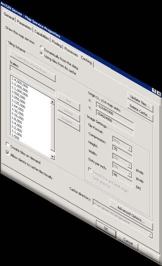
14 Cache Settings Data Projection North American Datum (NAD) 1983 State Plane North Carolina FIPS 3200 Feet (widely used by North Carolina State and local government) Scale Level Use ArcGIS Online or Google Maps to define scale levels When the cache level increases, the scale ratio will increase by 2. (round number/common map scale factors should be considered)


15 Cached Tile Scale Level 1:500,000 1:250,000 1:125,000
16 Cache Settings Data Format Use jpeg for raster data, use PNG8 for vector data Tile size, 256 by 256 pixel is a good choice (512 by 512 takes longer to download, less time to process) DPI For web applications and display purposes, the default of 96 DPI s is enough. For printing in ArcMap client, you can set a higher DPI. Anti-aliasing To show parcel data, it is better to turn this feature on.
17 Cache Settings Fused or Multi-layer Fused (best for online applications) Although there is the flexibility to turn on and off each individual layer, but try to avoid multilayer cache if possible. Multilayer caching reduces the performance and increases processing time.
18 More Cached Services Caching Process DAT Preparation
19 Pre-caching process Data preparation Image data should be already pyramided from ArcSDE, Statewide image data (large area) Design and view map in ArcMap to make sure the map is acceptable at every tile scale level (cached level) Extent Using the feature boundary will make less cached images than rectangle images Caching Maps Create and Manage the map service using ArcCatalog, set the maximum map instance to a number closer to the limits of the machine (the number of cores * 4)
")
20 NCDA&CS GIS Cached Map Service 5 cached map services Maps with less features will be processed faster It takes seven hours to process NAIP images at 1:2000 level for the whole state. (this scale is large enough for most applications)
21 Findings A Powerful server with more CPUs and memory will cache images much faster. It takes more time to generate images if the map service has more feature layers It takes longer to generate vector data layers with complex labeling It only takes several minutes to generate images from level 0 (1:4,000,000) to level 5 (1:125,000); doesn t matter if it s raster data or vector data

22
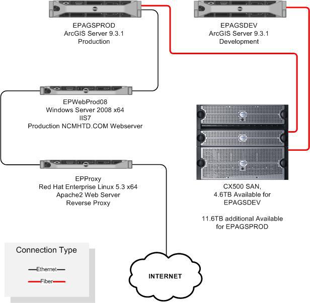
23 Architecture Design
24 Caching Comparison Operating System Old Test Server Windows Server 2003 GIS Server Windows Server 2008 Standard x64 IP Address (machine name) ArcGIS Server version Local Storage Space (EPGIS01) (EPAGSDEV) ArcGIS Server ArcGIS Server TB Total 1.00 TB Total SAN Storage Space TB for temporary TIFF Storage 3.58 TB for ArcGIS Server Storage Memory and CPU 4GB Ram (2) 3.66 GHz Intel Xeon Single Core 8GB Ram (2) 2.3 GHz Intel Xeon Quad Core Web Server IIS6 IIS7 with 32-bit Applications Enabled
25 Cache Map Service Comparison Processing Time (hours) Old Server New Server Storage Space NAIP2008 (level 10) 86 h 3 h 32 G NC_TRANS (level 10) No Testing 24 h 15.8 G NC_Roads (level 9) 6.33 h 1 h, 8 h for Level G (4.62G*) NC_flood (level 10) No Testing 3 h 15.5G (1.01G*) NC_soil (level 10) No Testing 2 h 15 G(2.28G*) Wake County (level 12) 46 h 109 h for level 13 No Testing Maximum instances 6-8 to be used 16 to be used 67.3G (57.6G*) Scale Level 10 = 1:4000, The time to generate cached images for the state of North Carolina at 1:4000 Level.

26 Disk Size Storage Consideration Size: 2.15 GB Size on disk: GB 4,104,828 Files /1,254 Folders Block size tuning based on your common file size on your folder Block size(from 4k to 1k)
27 ArcExplorer ArcGIS Desktop Cached Map Service Online GIS Application Others
28 Consuming Cache Maps on the web Navigation is limited to the tileing scheme scales Tiles cannot be re-projected To use ArcGIS Online mashups, Google Maps or Virtual Earth mashups Same coordinate system (Web Mercator) Same tile scheme levels (but can cache fewer levels) Not necessarily the same extent

29
30 Using Cache in ArcGIS Desktop High level of control over tile appearance Continuous zoom (pixelate from image in the nearest tile level) On-the-fly re-projection Create local cache If using cache map in ArcMap It is highly recommended to create maps using cached map scale Small scale maps will show dramatic performance improvement

31
32
33 Lessons Learned Planning Stage Spend more time creating and designing mxd files to make the map look decent at every cache level Processing Stage Use the maximum instances allowed for the ArcGIS server machine to cache images Pick the highest scale level carefully; don t create a scale too large. For the statewide data, a scale ratio larger than 1:2000 will take much more processing time and storage space. Cache your map service one level at a time instead of all at once
34 Lessons Learned (Continue) The processing time and storage space for the cached image will be about four times longer and larger than at the previous level, but this also depends on the feature details in each level. Total Processing time = ( ) * level_zero_processing_time Total Storage Space = ( ) * level_zero_storage_space (1kb in level 0, then 67 Gb in level 13)
35 Lessons Learned (Continue) View cached images from ArcMap client and web client to make sure they look correct with other features Cache small regions at all levels; pick high, normal and low feature-density areas for testing. Take advantage of nights and weekends to cache high level images Feature complexity, density, and labeling will affect the processing time

36 ArcGIS Online Highest Map Scale (1:4508)


37
38 Summary ArcGIS Server cached services makes fast-loading, online cartographic quality maps possible. It is worth making an investment in ArcGIS Server technology. The server memory and CPU will affect caching performance; if budget allows, buy the most powerful machine possible Since the cached image is pre-rendered, the reliability is also improved. For most GIS applications, setting the largest cache level as 1:2000 is enough.
39 Contributors for this presentation Daniel Madding Robert Hilton Yongjun Lei Tim Muhs Ed Shipman

40 QUESTIONS? NCDA&CS, Emergency Programs, ISS Group
Designing and Using Basemaps. Jennifer Hughey
 Designing and Using Basemaps Jennifer Hughey Agenda The ArcGIS System Basemaps are a key component of your system Cartographic design considerations Using basemap layers in ArcMap Best practices for designing
What should y you expect in this session? Basic to advanced topics Outline What is map caching? Why should I cache? Caching workflow How to create a c
 Designing, Deploying, and Using Cached Map Services David Crosby & Craig Mesimer What should y you expect in this session? Basic to advanced topics Outline What is map caching? Why should I cache? Caching
2013 Esri International User Conference July 8 12, 2013 San Diego, California
 Vistronix is a leader in Technology Solutions and Information Management Services. 2013 Esri International User Conference July 8 12, 2013 San Diego, California Building Cache Tiles with ArcGIS Server
Creating 2D Map Caches with
 Creating 2D Map Caches with ArcGIS Server 9.2 Presented by: The multi-threaded, threaded, over-clocked, dual core Diplo Matt Still AND the fast, the furious, the fully cached, Jonathan Fisk ArcGIS Server
How to Create a Tile Package
 United States Department of Agriculture Digital Mobile Sketch Mapping (DMSM) How to Create a Tile Package (TPK) Forest Service Introduction A tile package (.tpk) allows you to use a set of packaged tiles
Implementing and Optimizing ArcGIS Server Map Caches
 Implementing and Optimizing ArcGIS Server Map Caches Sterling Quinn Jeremy Bartley David Wilcox ESRI Developer Summit 2008 1 Schedule 75 minute session 60 65 minute lecture 10 15 minutes Q & A following
IndianaMap Release 3. Rick Hill, Paul Rohwer,, Chris Dintaman, Becky Meyer, and Denver Harper
 IndianaMap Release 3 Rick Hill, Paul Rohwer,, Chris Dintaman, Becky Meyer, and Denver Harper IndianaMap Agenda Session 1 & 2 Overview Tentative rollout schedule Old versus New Design and construction of
Advanced Map Caching. Tom Brenneman
 Advanced Map Caching g Topics Sterling Quinn Tom Brenneman Schedule Advanced topics Key caching properties C Caching g strategies g Test caches Strategic cache creation On--demand caching On Creating a
Designing and Using Cached Map Services
 Esri International User Conference San Diego, California Technical Workshops July 2012 Designing and Using Cached Map Services Sterling Quinn Eric Rodenberg What we will cover Session Topics - Map cache
Caching Imagery Using ArcGIS
 2013 Esri International User Conference July 8 12, 2013 San Diego, California Technical Workshop Caching Imagery Using ArcGIS Hong Xu, Hua Wei Esri UC2013. Technical Workshop. Presentation Goals Publish
An ESRI White Paper July 2009 Best Practices for Creating an ArcGIS Server Web Mapping Application for Municipal/Local Government
 An ESRI White Paper July 2009 Best Practices for Creating an ArcGIS Server Web Mapping Application ESRI 380 New York St., Redlands, CA 92373-8100 USA TEL 909-793-2853 FAX 909-793-5953 E-MAIL info@esri.com
Raster Serving with ArcGIS
 Raster Serving with ArcGIS Agenda Introduction to server technology Workflow considerations ESRI raster serving technology ArcGIS Server Basic (ArcSDE) ArcGIS Server Standard/Advanced Web Services ArcGIS
GIS Workshop Spring 2016
 1/ 14 GIS Geographic Information System. An integrated collection of computer software and data used to view and manage information about geographic places, analyze spatial relationships, and model spatial
RASTER ANALYSIS GIS Analysis Fall 2013
 RASTER ANALYSIS GIS Analysis Fall 2013 Raster Data The Basics Raster Data Format Matrix of cells (pixels) organized into rows and columns (grid); each cell contains a value representing information. What
GIS Basics for Urban Studies
 GIS Basics for Urban Studies Date: March 21, 2018 Contacts: Mehdi Aminipouri, Graduate Peer GIS Faciliator, SFU Library (maminipo@sfu.ca) Keshav Mukunda, GIS & Map Librarian Librarian for Geography (kmukunda@sfu.ca)
Lesson 3: Introduction to Using QGIS
 Agricultural Nutrient Management Program Department of Environmental Science and Technology 0116 Symons Hall 7998 Regents Dr. College Park, MD 20742 TEL 301-405-1319 FAX 301-314-7375 www.extension.umd.edu/anmp
Interactive Maps Purpose: Login to the System: Interactive Maps ONTINUE AGREE
 Interactive Maps Purpose: The purpose of this application is to provide the facility to the citizen to navigate to a Property through an On-line Free Web Application in real time. The application uses
In this lab, you will create two maps. One map will show two different projections of the same data.
 Projection Exercise Part 2 of 1.963 Lab for 9/27/04 Introduction In this exercise, you will work with projections, by re-projecting a grid dataset from one projection into another. You will create a map
RASTER ANALYSIS GIS Analysis Winter 2016
 RASTER ANALYSIS GIS Analysis Winter 2016 Raster Data The Basics Raster Data Format Matrix of cells (pixels) organized into rows and columns (grid); each cell contains a value representing information.
GPS TO GIS EXERCISE (30 PTS)
") GPS TO GIS EXERCISE (30 PTS) This exercise will allow you to demonstrate your cumulative knowledge of using a GPS receiver to collect data with locational information, downloading this data to a desktop
GPS TO GIS EXERCISE (30 PTS) This exercise will allow you to demonstrate your cumulative knowledge of using a GPS receiver to collect data with locational information, downloading this data to a desktop
INTRODUCTION TO GIS WORKSHOP EXERCISE
 111 Mulford Hall, College of Natural Resources, UC Berkeley (510) 643-4539 INTRODUCTION TO GIS WORKSHOP EXERCISE This exercise is a survey of some GIS and spatial analysis tools for ecological and natural
MODULE 1 BASIC LIDAR TECHNIQUES
 MODULE SCENARIO One of the first tasks a geographic information systems (GIS) department using lidar data should perform is to check the quality of the data delivered by the data provider. The department
Best Practices for Designing Effective Map Services
 2013 Esri International User Conference July 8 12, 2013 San Diego, California Technical Workshop Best Practices for Designing Effective Map Services Ty Fitzpatrick Tanu Hoque What s in this session Map
Installing the Toolkit
 Installing the Toolkit The Toolkit is an ArcGIS Add-in that is compatible with ArcGIS 10.0 and above. Please see the Toolkit website (http://www.fs.fed.us/eng/rsac/programs/teui/about.html) for previous
Map Tools: A Transformative Experience
 Bonus Chapter 3 Map Tools: A Transformative Experience The Autodesk AutoCAD Civil 3D 2016 software contains most of the functionality that can be found in the Autodesk AutoCAD Map 3D 2016 software. As
Architecting ArcGIS Server Solutions for Performance and Scalability
 Architecting ArcGIS Server Solutions for Performance and Scalability Dave Wrazien Eric Miller ESRI Developer Summit 2008 1 Schedule 75 minute session 60 65 minute lecture 10 15 minutes Q & A following
Remote Sensing in an
 Chapter 2: Adding Data to a Map Document Remote Sensing in an ArcMap Environment Remote Sensing Analysis in an ArcMap Environment Tammy E. Parece Image source: landsat.usgs.gov Tammy Parece James Campbell
Making the Most of Raster Analysis with Living Atlas Data. Aileen Buckley, PhD, Research Cartographer Esri - Redlands
 Making the Most of Raster Analysis with Living Atlas Data Aileen Buckley, PhD, Research Cartographer Esri - Redlands Spatial Analysis with Online Data Your Desktop Web Device Never scrounge for or download
Web Server (IIS 6) ArcGIS Server 9.1. ArcGIS Server 9.1 Server Object Manager. Server Object Container
 ArcGIS Server 9.1. ArcGIS Server 9.1 Server Object Manager. Server Object Container") Deploying and Tuning ArcGIS Server Presented by Jim Mason and Ian Sims ESRI Server Development ArcGIS Server Case Study San Francisco Routing Application Point to Point Driving Directions Enter Two Addresses
Deploying and Tuning ArcGIS Server Presented by Jim Mason and Ian Sims ESRI Server Development ArcGIS Server Case Study San Francisco Routing Application Point to Point Driving Directions Enter Two Addresses
ArcGIS Server: publishing geospatial data to the web using the EEA infrastructure
 ArcGIS Server: publishing geospatial data to the web using the EEA infrastructure *IMPORTANT: Map Services should be published using the EEA Map Services Tick Sheet for guidance. Contact Sebastien Petit
Web Map Caching and Tiling. Overview David M. Horwood June 2011
 Web Map Caching and Tiling Overview David M. Horwood dhorwood@esricanada.com June 2011 Web Mapping Traditional Geographic projection Select / Refresh workflow Slow, non-interactive (refresh delay) http://www.geographynetwork.ca/website/obm/viewer.htm
Exercise 4: Import Tabular GPS Data and Digitizing
 Exercise 4: Import Tabular GPS Data and Digitizing You can create NEW GIS data layers by digitizing on screen with an aerial photograph or other image as a back-drop. You can also digitize using imported
GIS-Generated Street Tree Inventory Pilot Study
 GIS-Generated Street Tree Inventory Pilot Study Prepared for: MSGIC Meeting Prepared by: Beth Schrayshuen, PE Marla Johnson, GISP 21 July 2017 Agenda 2 Purpose of Street Tree Inventory Pilot Study Evaluation
QGIS Tutorials Documentation
 QGIS Tutorials Documentation Release 0.1 Nathaniel Roth November 30, 2016 Contents 1 Installation 3 1.1 Basic Installation............................................. 3 1.2 Advanced Installation..........................................
An Introduction to Geographic Information Systems (GIS) using ArcGIS 9.2
 using ArcGIS 9.2") An Introduction to Geographic Information Systems (GIS) using ArcGIS 9.2 by Marcel Fortin, GIS and Map Librarian, University of Toronto Libraries, 2009 gis.maps@utoronto.ca http://www.library.utoronto.ca/maplib/
An Introduction to Geographic Information Systems (GIS) using ArcGIS 9.2 by Marcel Fortin, GIS and Map Librarian, University of Toronto Libraries, 2009 gis.maps@utoronto.ca http://www.library.utoronto.ca/maplib/
Geographical Information Systems Institute. Center for Geographic Analysis, Harvard University. LAB EXERCISE 1: Basic Mapping in ArcMap
 Harvard University Introduction to ArcMap Geographical Information Systems Institute Center for Geographic Analysis, Harvard University LAB EXERCISE 1: Basic Mapping in ArcMap Individual files (lab instructions,
GIS Tools for Hydrology and Hydraulics
 1 OUTLINE GIS Tools for Hydrology and Hydraulics INTRODUCTION Good afternoon! Welcome and thanks for coming. I once heard GIS described as a high-end Swiss Army knife: lots of tools in one little package
Juniata County, Pennsylvania
 GIS Parcel Viewer Web Mapping Application Functional Documentation June 21, 2017 Juniata County, Pennsylvania Presented by www.worldviewsolutions.com (804) 767-1870 (phone) (804) 545-0792 (fax) 115 South
Introduction to CacheWorx. Lucian Plesea - Esri Robert Jensen - Esri
 Introduction to Lucian Plesea - Esri Robert Jensen - Esri What is? Cache content analysis toolset Content Assessment Error Detection Optimization Opportunities Resource Allocation ArcMap Toolbox - Freeware:
Peoria County Front Desk Map Application
 Peoria County Front Desk Map Application Quick Guide, 2017 At a First Glance This guide will tell users all they need to know about the Peoria County Front Desk application which can be found on the Peoria
Geography 281 Mapmaking with GIS Project One: Exploring the ArcMap Environment
 Geography 281 Mapmaking with GIS Project One: Exploring the ArcMap Environment This activity is designed to introduce you to the Geography Lab and to the ArcMap software within the lab environment. Before
City of La Crosse Online Mapping Website Help Document
 City of La Crosse Online Mapping Website Help Document This document was created to assist in using the new City of La Crosse online mapping sites. When the website is first opened, a map showing the City
Managing Image Data on the ArcGIS Platform Options and Recommended Approaches
 Managing Image Data on the ArcGIS Platform Options and Recommended Approaches Peter Becker Petroleum requirements for imagery and raster Traditional solutions and issues Overview of ArcGIS imaging capabilities
Review of Cartographic Data Types and Data Models
 Review of Cartographic Data Types and Data Models GIS Data Models Raster Versus Vector in GIS Analysis Fundamental element used to represent spatial features: Raster: pixel or grid cell. Vector: x,y coordinate
ArcGIS for Server: Optimizing Performance and Scalability
 ArcGIS for Server: Optimizing Performance and Scalability Anthony Myers & Kevin Armstrong Introduction Today we will discuss - Architecture - Map and Image Services - What s New - Tips and Techniques Throughout
ArcGIS Desktop: Fundamentals of Cartography
 ArcGIS Desktop: Fundamentals of Cartography Outline Symbology Style Files -.style Layer files -.lyr Labeling Label Classes Label Expressions Map Document files -.mxd Map Template files -.mxt Map Elements
Introduction to ArcGIS Server 10.1
 Introduction to ArcGIS Server 10.1 E-Learning for the GIS Professional Any Time, Any Place! geospatialtraining.com Module Outline What is ArcGIS Server? GIS Resources and Services ArcGIS Server Components
Assembling Datasets for Species Distribution Models. GIS Cyberinfrastructure Course Day 3
 Assembling Datasets for Species Distribution Models GIS Cyberinfrastructure Course Day 3 Objectives Assemble specimen-level data and associated covariate information for use in a species distribution model
This guide will tell you all you need to know about the new Front Desk application which can be found on the main Peoria County GIS website.
 New Front Desk Quick Guide, 2014 At a First Glance This guide will tell you all you need to know about the new Front Desk application which can be found on the main Peoria County GIS website. When you
SAGIS Property Map Viewer Instruction Manual Instructions for using the SAGIS Property Map Viewer. Published December 21, 2018.
 SAGIS Property Map Viewer Instruction Manual www.sagis.org/map Instructions for using the SAGIS Property Map Viewer. Published December 21, 2018. 1 Instructional Videos Click on a link to watch a video
Server Usage & Third-Party Viewers
 Server Usage & Third-Party Viewers October 2016 HiPER LOOK Version 1.4.16.0 Copyright 2015 PIXIA Corp. All Rights Reserved. Table of Contents HiPER LOOK Server Introduction... 2 Google Earth... 2 Installation...2
Building Basemaps: MapCaches and VectorTiles. Matthias Schenker Gerhard Trichtl
 Building Basemaps: MapCaches and VectorTiles Matthias Schenker Gerhard Trichtl What are Basemaps for Basemaps provide a optimal background and orientation for displaying your data on top Should be - Fast
P2 MANUAL FOR WEB-BASED TXDOT RIGID PAVEMENT DATABASE. Authors: Sureel Saraf Moon Won
 0-5445-P2 MANUAL FOR WEB-BASED TXDOT RIGID PAVEMENT DATABASE Authors: Sureel Saraf Moon Won TxDOT Project 0-5445: Project Level Performance Database for Rigid Pavements in Texas SEPTEMBER 2007, REV. JULY
ArcGIS Desktop The Road Ahead. Amadea Azerki
 ArcGIS Desktop The Road Ahead Amadea Azerki Agenda An Overview of ArcGIS 10 Desktop Enhancements User Interface Mapping Editing Analysis Sharing Q & A ArcGIS 10 Overview Focuses on Usability and Productivity
ROCKY FORK TRACT: VIEWSHED ANALYSIS REPORT
 ROCKY FORK TRACT: VIEWSHED ANALYSIS REPORT Prepared for: The Conservation Fund Prepared by: A Carroll GIS 3711 Skylark Trail Chattanoga, TN 37416 INTRODUCTION This report documents methods and results
Livingston County MAP User Guide
 Livingston County MAP User Guide Need help with the Livingston County MAP? Click the button located on each tool s window to view the help documentation for that specific tool. If you need additional information
City of Richmond Interactive Map (RIM) User Guide for the Public
 User Guide for the Public") Interactive Map (RIM) User Guide for the Public Date: March 26, 2013 Version: 1.0 3479477 3479477 Table of Contents Table of Contents Table of Contents... i About this
Interactive Map (RIM) User Guide for the Public Date: March 26, 2013 Version: 1.0 3479477 3479477 Table of Contents Table of Contents Table of Contents... i About this
Introduction to GIS & Mapping: ArcGIS Desktop
 Introduction to GIS & Mapping: ArcGIS Desktop Your task in this exercise is to determine the best place to build a mixed use facility in Hudson County, NJ. In order to revitalize the community and take
Best Practices for Managing Scanned Imagery. Peter Becker
 Best Practices for Managing Scanned Imagery Peter Becker Objectives Making Scanned Imagery Accessible - Topographic maps - Historic scanned maps - Navigation maps - Engineering drawings Uses of Scanned
Geography 281 Mapmaking with GIS Project One: Exploring the ArcMap Environment
 Geography 281 Mapmaking with GIS Project One: Exploring the ArcMap Environment This activity is designed to introduce you to the Geography Lab and to the ArcMap software within the lab environment. Please
GIS Workbook #1. GIS Basics and the ArcGIS Environment. Helen Goodchild
 GIS Basics and the ArcGIS Environment Helen Goodchild Overview of Geographic Information Systems Geographical Information Systems (GIS) are used to display, manipulate and analyse spatial data (data that
Lesson 2 Installing and Using Quantum GIS (QGIS)
") Lesson 2 Installing and Using Quantum GIS (QGIS) Use file Explorer to open County QGIS portable hard drive provided. The program execute (.exe) will be at the bottom of the list. Double click on the file.
Lesson 2 Installing and Using Quantum GIS (QGIS) Use file Explorer to open County QGIS portable hard drive provided. The program execute (.exe) will be at the bottom of the list. Double click on the file.
2) Make sure that the georeferencing extension is on by right-clicking in the task bar area and selecting Georeferencing
 Make sure that the georeferencing extension is on by right-clicking in the task bar area and selecting Georeferencing") HGIS Workshop Module 1 Georeferencing Large Scale Scanned Historical Maps Objective: Learn the Principles of Georeferencing 1) In ArcMap, open the project 01 data\arcdata_10_1\arcdata\toronto\georeference.mxd
HGIS Workshop Module 1 Georeferencing Large Scale Scanned Historical Maps Objective: Learn the Principles of Georeferencing 1) In ArcMap, open the project 01 data\arcdata_10_1\arcdata\toronto\georeference.mxd
Basics of Using LiDAR Data
 Conservation Applications of LiDAR Basics of Using LiDAR Data Exercise #2: Raster Processing 2013 Joel Nelson, University of Minnesota Department of Soil, Water, and Climate This exercise was developed
Tileset Concepts and Terminology
 Tileset Concepts and Terminology Bing Maps Your Geodata raster Bing Maps vector shape CAD Google Maps Google Maps NASA World Wind Google Earth Google Earth MicroImages, Inc. 11th Floor - Sharp Tower 206
SERVER GIS: HIGH PERFORMANCE DELIVERED!
 SERVER GIS: HIGH PERFORMANCE DELIVERED! Jayateerth Deshpande & Sanjay Shrivastava Reliance Industries Ltd. Abstract: In the current era of using web technologies for sharing information, WebGIS is becoming
Exercise 5: Import Tabular GPS Data and Digitizing
 Exercise 5: Import Tabular GPS Data and Digitizing You can create NEW GIS data layers by digitizing on screen with an aerial photograph or other image as a back-drop. You can also digitize using imported
An Introduction to Lidar & Forestry May 2013
 An Introduction to Lidar & Forestry May 2013 Introduction to Lidar & Forestry Lidar technology Derivatives from point clouds Applied to forestry Publish & Share Futures Lidar Light Detection And Ranging
The ArcMap Interface and Using Basic ArcMap Analysis Tools to Create a Map
 The ArcMap Interface and Using Basic ArcMap Analysis Tools to Create a Map *You will need a computer with ESRI ArcGIS Desktop version 9.3 or higher installed* Data Download 1. Save the zipped folder with
MrSID Plug-in for 3D Analyst
 LizardTech MrSID Plug-in for 3D Analyst User Manual Copyrights Copyright 2009 2010 LizardTech. All rights reserved. Information in this document is subject to change without notice. The software described
ArcGIS Runtime: Styling Maps. Ralf Gottschalk, Daniel Lee, Lucas Danzinger
 ArcGIS Runtime: Styling Maps Ralf Gottschalk, Daniel Lee, Lucas Danzinger Map Styling What is this session about? Creating beautiful functional maps for your Runtime Apps - Not about cartography It is
Getting Started with ArcGIS for Server. Charmel Menzel and Ken Gorton
 Getting Started with ArcGIS for Server Charmel Menzel and Ken Gorton Agenda What is ArcGIS for Server? Types of Web services Publishing resources onto the Web Clients to ArcGIS for Server Editions and
Watershed Modeling Orange County Hydrology Using GIS Data
 v. 9.1 WMS 9.1 Tutorial Watershed Modeling Orange County Hydrology Using GIS Data Learn how to delineate sub-basins and compute soil losses for Orange County (California) hydrologic modeling Objectives
دورة تدريبية عن تطبيقات برنامج ARC GIS
 دورة تدريبية عن تطبيقات برنامج ARC GIS مايو 2009 دورة تدريبيت عن تطبيقاث برنامج ARC GIS 2009 مايو Table of Contents Introduction... viii Module 1: Introduction to ArcGIS 9 Module Objectives... 1-1 ArcGIS
Making ArcGIS Work for You. Elizabeth Cook USDA-NRCS GIS Specialist Columbia, MO
 Making ArcGIS Work for You Elizabeth Cook USDA-NRCS GIS Specialist Columbia, MO 1 Topics Using ArcMap beyond the Toolkit buttons GIS data formats Attributes and what you can do with them Calculating Acres
RDF Databases Made ArcGIS Friendly
 RDF Databases Made ArcGIS Friendly Submitted by: Michael D. Tsengouras Lead Engineer NAVTEQ Research and Development - MAP Expansion May 15, 2010 Introduction The purpose of this paper is to present an
Best Practices for Designing Effective Map Services
 FedGIS Conference February 24 25, 2016 Washington, DC Best Practices for Designing Effective Map Services James Tedrick, Esri Matt Sokol, MD Dept. of Information Technology Web Mapping & Service Types
Introduction to ArcGIS Desktop
 Introduction to ArcGIS Desktop Prepared by David R. Maidment Center for Research in Water Resources University of Texas at Austin September 2011 Contents Goals of the Exercise Computer and Data Requirements
1. Start ArcMap by going to the Start menu > All Programs > ArcGIS > ArcMap.
 Learning ArcGIS: Introduction to ArcMap 10.1 The Map Document Feature Manipulation Navigating ArcMap Map Documents, Layers, and Features Shapes, Location, and Attribute Data Symbology Zoom, Pan and Map
_Tutorials. Arcmap. Linking additional files outside from Geodata
 _Tutorials Arcmap Linking additional files outside from Geodata 2017 Sourcing the Data (Option 1): Extracting Data from Auckland Council GIS P1 First you want to get onto the Auckland Council GIS website
This will display various panes in a window.
 Map Map projections in ArcMap can be a bit confusing, because the program often automatically reprojects data for display, and there are a ways to permanently project data to new data sets. This describes
Getting Started With LP360
 Getting Started With LP360 12/22/2015 1 Contents What is LP360?... 3 System Requirements... 3 Installing LP360... 4 How to Enable the LP360 Extension... 4 How to Display the LP360 Toolbar... 4 How to Import
ArcGIS for Server Administration. Andrew Sakowicz
 ArcGIS for Server Administration Andrew Sakowicz asakowicz@esri.com Target audience Administrators (GIS, DBA, System) Architects Developers Level: Intermediate Outline Key administrative functions Configuring
Data Assembly, Part II. GIS Cyberinfrastructure Module Day 4
 Data Assembly, Part II GIS Cyberinfrastructure Module Day 4 Objectives Continuation of effective troubleshooting Create shapefiles for analysis with buffers, union, and dissolve functions Calculate polygon
Taking Advantage of the Explosion in Online Imagery with Autodesk Raster Design.
 11/28/2005-1:00 pm - 2:30 pm Room:Osprey 2 [Lab] (Swan) Walt Disney World Swan and Dolphin Resort Orlando, Florida Taking Advantage of the Explosion in Online Imagery with Autodesk Raster Design. Gary
ERDAS Image Web Server Datasheet
 ERDAS Image Web Server Datasheet age 1 of 10 ERDAS Image Web Server Image serving protocols Multi-protocol support Expose images with different protocols. ERDAS Compressed Wavelet Protocol (ECWP) image
Finding GIS Data and Preparing it for Use
 02-Finding_Data_And_Preparing_It_For_GIS_Analysis_92.Doc Page 1 of 16 Getting Ready for the Tutorial Sign Up for the GIS-L Listserv Finding GIS Data and Preparing it for Use The Yale University GIS-L Listserv
United States Department of Agriculture
 United States Department of Agriculture Geospatial Data Warehouse Implementation Kevin Clarke USDA Farm Service Agency Salt Lake City, UT Art Ullman USDA Natural Resources Conservation Service Fort Worth,
OziExplorer Training and Help Manual for Use with Soil Resource Stewardship Monitoring Checklist: Cutblock-Level
 for Use with Soil Resource Stewardship Monitoring Checklist: Cutblock-Level Stéphane Dubé, Soil Scientist MOFR Northern Interior Forest Region May 2009 Version 2 Starting up This section will describe
Image Services for Elevation Data
 Image Services for Elevation Data Peter Becker Need for Elevation Using Image Services for Elevation Data sources Creating Elevation Service Requirement: GIS and Imagery, Integrated and Accessible Field
Objectives Learn how to work with projections in GMS, and how to combine data from different coordinate systems into the same GMS project.
 v. 10.2 GMS 10.2 Tutorial Working with map projections in GMS Objectives Learn how to work with projections in GMS, and how to combine data from different coordinate systems into the same GMS project.
Geocoding Reference USA data in ArcMap 9.3
 Tufts GIS Tip Sheet Geocoding Reference USA data in ArcMap 9.3 Written by Barbara Parmenter Revised 3/1/2011 In this exercise, you will map businesses or services for a town in the Boston metropolitan
George Mason University Department of Civil, Environmental and Infrastructure Engineering
 George Mason University Department of Civil, Environmental and Infrastructure Engineering Dr. Celso Ferreira Prepared by Lora Baumgartner December 2015 Revised by Brian Ross July 2016 Exercise Topic: GIS
Development of an Interactive Web Interface for Spatial Data Warehousing
 Development of an Interactive Web Interface for Spatial Data Warehousing by Nathan K. Eaton Abstract: Finding a specific file to download is an inherent problem with many online spatial data clearinghouses.
Lab.4 & Assignment 2. Lab4. Conversion of Hardcopy Map to ArcGIS Map
 EATS4400 GIS Lab.4 & Assignment 2 Lab4 Conversion of Hardcopy Map to ArcGIS Map In this lab exercise you will have chance to go through the steps to convert hardcopy map into digital map for ArcGIS. Digitizing
GEO 465/565 Lab 6: Modeling Landslide Susceptibility
 1 GEO 465/565 Lab 6: Modeling Landslide Susceptibility This lab will give you more practice in understanding and building a GIS analysis model. Recall from class lecture that a GIS analysis model is a
Architectural Level of Study of ArcGIS Server
 Architectural Level of Study of ArcGIS Server Annie Vinuthna D, II year M.Tech, Computer Science & Engineering Department, P.J.R.Shalem Raju, Senior Assistant Professor, Computer Science & Engineering
ArcGIS Basics 2: Creating a Map with ArcMap
 ArcGIS Basics 2: Creating a Map with ArcMap Revised 25 August 2010 Tufts University Author: Barbara Parmenter Introduction... 1 Part 1 - Opening ArcMap and adding data layers... 2 Part 2 - Defining the
Best Practices for Managing Processed Ortho Imagery
 Best Practices for Managing Processed Ortho Imagery Cody Benkelman DRAFT slides (June 2017) Characteristics of Processed Ortho Imagery Typically 8 bit (sometimes 16) Typically 3 spectral bands (sometimes
Chapter 17 Creating a New Suit from Old Cloth: Manipulating Vector Mode Cartographic Data
 Chapter 17 Creating a New Suit from Old Cloth: Manipulating Vector Mode Cartographic Data Imagine for a moment that digital cartographic databases were a perfect analog of the paper map. Once you digitized