WCS2.1 Met-Ocean. 16 th Workshop on Operational Systems. Crown copyright Met Office
|
|
|
- Adela Darlene Page
- 5 years ago
- Views:
Transcription

1 WCS2.1 Met-Ocean 16 th Workshop on Operational Systems Crown copyright Met Office
 Paul Hershberg and Steve Olson National Oceanic and Atmospheric Administration (NOAA) National Weather Service (NWS) Crown copyright Met")
2 A Revolutionary Approach to Multi- Dimensional Data Access of Gridded Datasets Using Current and Proposed OGC Web Coverage Standards 16 th Workshop on Operational Systems ECMWF Reading 2 nd March, 2017 Peter Trevelyan UK Met Office (UKMO) Paul Hershberg and Steve Olson National Oceanic and Atmospheric Administration (NOAA) National Weather Service (NWS) Crown copyright Met Office
3 Table Of Contents Background Issues with Coverages Paradigm Shift in thinking about Coverages The MetOcean App Profile: Adding Functionality to WCS Core Key Benefits of MetOcean Application Profile -- 1) Coverage Collection -- 2) New Structural Patterns -- 3) Describe Coverages as an Observational Type -- Effect of 2D coverages versus 4D, a GFS model case study -- 4) New Data Extraction Patterns Current Status/Results -- Demo of a MetOcean Application Profile Implementation Future Plans Questions Backup Slides Crown copyright Met Office

4 Background: Coverages Phenomena that vary over geospatial domains Defined by Domain and Range Radar Vertical Profiles Time Series Wind Profiles Radiosondes Satellite Data NWP model output


5 Background: OGC Web Coverage Service (WCS) Gridded Data Publish as a service with OGC Standards Request & Response API s WCS GetCapabilities DescribeCoverage GetCoverage GRIB2, NetCDF, etc

6 So What s the problems? Data Size, Volume, Resolution insufficient storage, computer resources, bandwidth Transfer of MetOcean data sets harder to push thru web services Subsetting Returns only data necessary to consumer WCS Core Functionality: Trimming, Slicing, but lacking Not tailored to specific MetOcean community s needs. Interoperability Improvement between disparate web services. Needed for global cooperation Can we describe MetOcean WCS data in a community-based controlled vocabulary? MultiDimensionality MetOcean data inherently 4D (x/y/z/t) WCS Coverages often 2D Size, # WCS Requests & Responses w/ 2D Coverages unwieldy Need new way of thinking about MetOcean (x/y)

7 Paradigm Shift in thinking about Coverages Allows consumers ability to singularly extract 4D/5D/+ data over geography, time, altitude, & ensembles, + Coverages: Stack 2D One 4D WCS2.1 Core allows 2D 4D Reduces # of Cov s Reduces # of WCS Transactions! Depict whole atmosphere as a multidimensional simulation Coverages!= Temp, Wspd, etc Sample atmosphere as 1 4D object Access Higher Dimensions (5D +)

8 Service Extensions Processing Range Subsetting Interpolation Scaling CRS WCS Core Functionality Application Profiles Earth Observation
9 The main problem with the description of geospatial data is that is product based For example the names of layers are usually as follows:- Height_200hPa_T+24_GFS_ T03:30:00Z Need to be data centric This is not geospatial and each layer is explicitly requested by name/ Think of the atmosphere as a multi-dimensional cube. The number of dimensions is not limited, but normally x,y,z,t with the addition of ensemble. This hyper cube has properties e.g. temperature, wind, humidity, max wind level etc. The requests are then truly geo-spatial and only refer to the converge identifier, not a product name!they query the cube in terms of its dimensions and properties.


10 WCS 2.0 Core GetCoverage Operation Slice Operation (Dimension Reduction) Trim Operation (Extent Reduction) Courtesy Jozef Matula IBL
11 Start with an example: Source coverage data is potentially N dimensional just like variables in NetCDF. Can have X, Y, Z (vertical level), Time. Slice operation reduces dimensions e.g. from 3D to 2D. Sounds promising for vertical profile extraction. Trim operation implements dimension range filtering, if typically applied to both X and Y. Sounds promising for geospatial data BBOX extraction. Slice and Trim can be requested in other coordinate reference systems (CRS) than the CRS of the source data (re-projection) Courtesy Jozef Matula IBL

12 Meteorological Data Extraction Patterns Z X Imagine 3D data cube without time Courtesy Jozef Matula IBL
13 Meteorological Data Extraction Patterns Extracting data for a point = Slice X, Slice Y, Slice Z Courtesy Jozef Matula IBL
14 Meteorological Data Extraction Patterns Extracting vertical profile data for a point = Slice X, Slice Y With vertical range = Slice X, Slice Y, Trim Z Courtesy Jozef Matula IBL
15 Meteorological Data Extraction Patterns Extracting data for 2D geospatial domain for a single vertical level = Trim X, Trim Y, Slice Z Courtesy Jozef Matula IBL
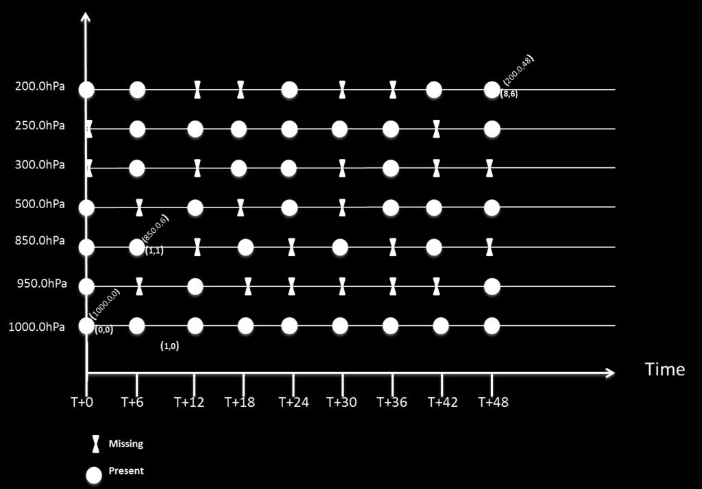
16 Met-Ocean Data Extraction. All mentioned patterns were purely geospatial and height related. Is the time is just yet another 4th dimension? We need to take into account: Forecast validity time. Model run reference time. Ensemble member dimension. This potentially creates a 6D coverage?! Not to be forgotten too - sampling and interpolation. Crown copyright Met Office
17 Meteorological Data Extraction Patterns Extracting vertical profile data for 2D geospatial domain = Trim X, Trim Y, Trim Z Courtesy Jozef Matula IBL
18 Meteorological Data Extraction Patterns T(0) T(0.3) T(0.6) T(1) Extracting data for a trajectory (for example road) = Trim in Trajectory CRS + Slice in Z. Trajectory CRS is 1 dimensional function T(q) for q in <0;1> mapping q to actual X, Y coordinates! Courtesy Jozef Matula IBL
19 Meteorological Data Extraction Patterns Extracting vertical profile data for a trajectory = Trim in Trajectory CRS
20 Meteorological Data Extraction Patterns T(0) T(0.3) T(0.6) T(1) Extracting data for a 3D trajectory (airplane) flight) = Trim in 3D Trajectory CRS 3D Trajectory CRS is 1 dimensional function T(q) for q in <0;1> mapping q to real X,Y,Z coordinates. Courtesy Jozef Matula IBL

21 MetOcean Profile s Benefits to the WCS Core to Address new MetOcean Coverages
22 Coverage Collection Provide a very powerful way of grouping MetOcean Coverages. A NWP model run is in fact a coverage collection NWP Model Simulations Radar Mosaics Climate Observations A single, uniquely identified resource consisting of member coverages related by common geospatial properties. Treated as a single geospatial object Address multidimensionality by further REDUCING the number of individual coverages, relevant to the GetCapbilites response. Attribute Common Metadata to entire collection, not each member coverage. New MetOcean operation DescribeCoverageCollection Returns member coverages with a simple API
23 New Data Structural Patterns (GetCapabilities Response document) Groups Provides a hierarchical way of nesting services. Supports Service End Points, allowing for a Fully Distributed System Collections Return Info on Collections only, not individual member Coverages Organizes & reduces amt of service metadata returned in GetCapabilities Response!! Increases Efficiency of Web Services!!
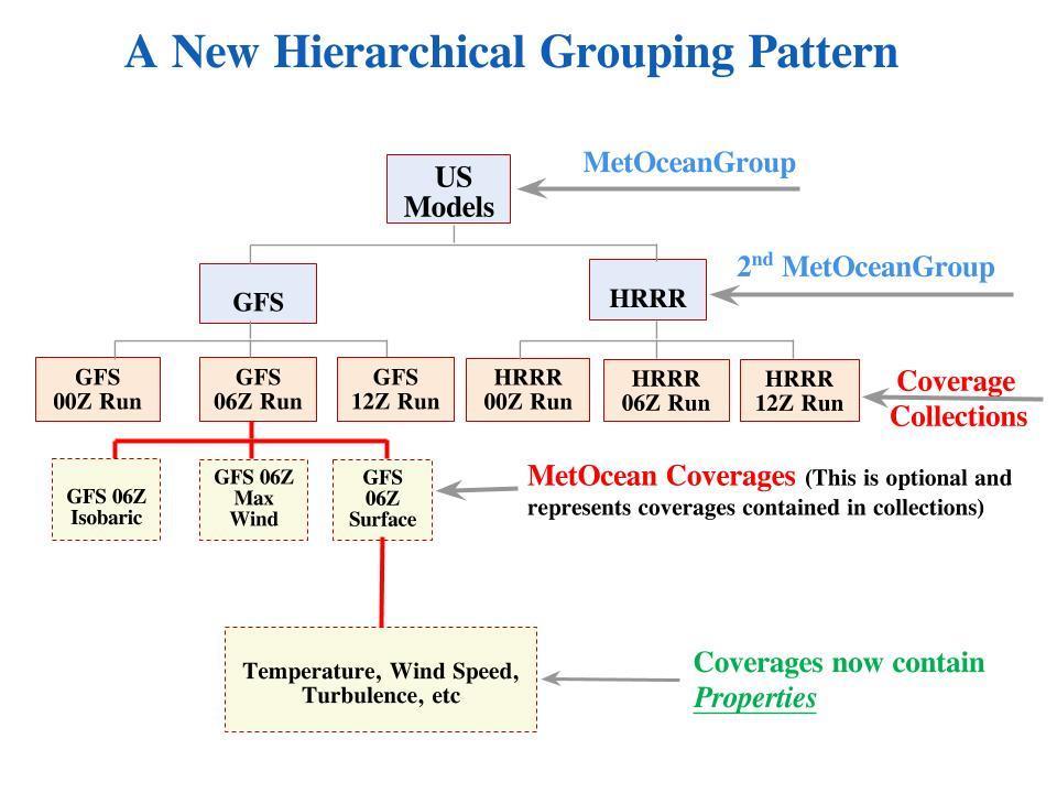
24 (cont)
. Benefits of using O&M Uses common Weather/Oceanic Vertical Reference Systems. Supports Links for references.")
25 Describing a MetOcean Coverage as an Observational Type Current Obs -> Models -> Wx, Ocean, Climate Forecast Simulations Simulations have properties describing characteristics of models Define coverage metadata as a specialized O&M type (ISO 19156). Benefits of using O&M Uses common Weather/Oceanic Vertical Reference Systems. Supports Links for references. Initial release supports WMO GRIB2 tables and concepts, but may be expanded. The metadata is not tied to a specific data format i.e. GRIB2. By linking to WMO registers (e.g. there is support for a controlled vocabulary, facilitating interoperability and extensibility. A mechanism for Quality Control using a Data Mask (See Backup Slide #25) Denotes at which forecast projection data is valid for. A method to enumerate non-regular axes to support time and vertical dimensions. Key in 2D 4D. (See Backup Slide #24) Organizes metadata in a more common sense manner in a DescribeCoverage Response!!
 2D: ~ 10,000 individual coverages 4D: ~ 6 individual coverages Effect on GetCapabilities Response Doc (that lists the coverages) 2D: ~ 30,000 lines of XML! 4D: ~ 200 lines of XML!")
26 Effect of 4D coverages versus 2D coverages on web services: the GFS model, a case study User to extract GFS Model (one run time, e.g 06Z) 2D: ~ 10,000 individual coverages 4D: ~ 6 individual coverages Effect on GetCapabilities Response Doc (that lists the coverages) 2D: ~ 30,000 lines of XML! 4D: ~ 200 lines of XML! Effect on GetCoverage Request Number 2D: User makes 10,000 Requests 4D: User makes only 6 Requests Massive Reduction in Amt of data Returned! Massive Reduction in Amt of data Requests! Bottom line is MetOcean supports WCS operations that support multidimensionality with 4D Coverages (x,y,z,t).


27 New Operations to Query MetOcean Data Complex Data Extraction Derived/Developed from Multi Dimensionality and 4D Coverage Tailored to common MetOcean Data Shapes More Explicit than WCS GetCoverage operation GetPolygon Area or Volume GetCorridor
28 Current Status And Results: A Demo A web service implementation featuring the full MetOcean Profile has been built & tested using UK Met & US NWS data! The MetOcean Application Profile is still in need of comment! Links to the MetOcean Profile on the OGC website:
29 MetOcean Demonstration To highlight the key MetOcean features the profile has extended over WCS 2.1 Core, a transcontinental flight demo will be shown that can request/receive info from a single proxy service. This proxy setup shows how multiple WCS servers can be accessed as separate component requests. Over UK airspace, proxy retrieves info from UK server Over US airspace, proxy retrieves info from US server May be beneficial as an aviation/marine DST (NextGen/SESAR)
 Proxy")
30 MetOcean Demonstration (cont) London s Heathrow Airport to Denver Colorado s Airport. Show extraction of WAFS data along the flight Show a single user request to the proxy service Using single identifier Access data from a 4D hyper cube (lat, lon, time, and vertical coord) Proxy Service requests data from 2 disparate WCS servers Each WCS request accesses a hemisphere cut out of global data The Flight Planning Client retrieves from the proxy server a stitched grid (merged product) Proxy server has a virtual copy of the re-constituted data cube. Merged Product is then used to construct the corridor data Copyright 2016 Open Geospatial Consortium
31 MetOcean Demonstration (cont) Not all use cases will be demonstrated due to time, but shown will be a live demo of these Requests: GetCapabilites ( etcapabilities) DescribeCoverageCollection ( escribecoveragecollection&coveragecollectionid=kwbc_ T Z) DescribeCoverage ( Coverage&COVERAGEID=KWBC_ T Z_ISBL) NOTE: make sure datetime is valid/current in above URL s
32 Demo Link:
33 Future Plans Multi slicing and trimming with a single GetCoverage operation. Allows extraction of Multi pts/cross sections from one GetCoverage operation. Standardize MetOcean CRS, vertical levels, etc. Based on the WMO standards. Add formal extension for GetCorridor & GetPolygon Investigate adding a pub/sub model for offering subscription service. Explore adding data formats with metadata. Explore encoding coverages in JSON (CovJSON) in addition to XML. Add support for 5D ensemble members. Incorporate MetOcean DWG requests/comments.
34 Questions?
35 Backup Slides:
36 GetCapabilities GML GetCapabilities-Exrension «DataType» MetOcean::Cov eragesummary «DataType» w cs:extension + wcs:coverageid :NCName + cis:envelope :cis:axisextent + ows:metadata :ows::abstractmetadata +coveragesummary 0..* 0..* «DataType» Cov eragecollectionmetadata + metocean:name :string [0..1] + metocean:serviceinstant :anyuri [0..1] + ows:metadata :ows:abstractmetadata [0..1] last +coveragecollectionsummary 0..* «DataType» cov coll:cov eragecollectionsummary «DataType» MetOcean::Group +group 0..* + covcoll:coveragecollectionid :NCName + cis:envelope :cis:axisextent + ows:metadata :ows:abstractmetadata last 0..1 «DataType» SimulationCollection +simulationcollection 0..* «DataType» DescribeableCoverageCollection + cis:envelope :cis:axisextent [0..1] +simulationmember 1..* «DataType» metocean:simulationmember +simulationcoveragesummary 0..* «DataType» SimulationCov eragesummary «XSDchoice» AdditionalMetadata + covcoll:referencetime :gml:timeposition + :referencetimeaxis :cis:regularaxis + referencetimeaxis :cis:irregularaxis «DataType» ow s:abstractmetadata
 class CIS::AbstractGridCov erage (as per grid-regular) (for reference only) CIS::AbstractCoverage «Feature T ype» CIS::AbstractGridCov erage")
37 L Model for CIS 1.1 llows Derivation of one 4D coverage -> many 2D verages) class CIS::AbstractGridCov erage (as per grid-regular) (for reference only) CIS::AbstractCoverage «Feature T ype» CIS::AbstractGridCov erage «Feature T ype» CIS::GeneralGridCov erage «Feature T ype» CIS::GridCov erage + envelope :GML::Envelope «Feature T ype» CIS::RectifiedGridCov erage + envelope :GML::Envelope +domainset «Data Type» CIS::GeneralGrid + srsname :anyuri + axislabels :string [1..*] + srsdimension :positiveinteger + griddimension :positiveinteger +domainset «Data Type» GML::Grid +domainset «Data Type» GML::RectifiedGrid deprecated


38 Quality Control using a Data Mask
39 2D Coverages, a Case Study (Note: choose Presentation mode for scroll bar availability <?xml version="1.0" encoding="utf-8"?> <wcs:capabilities updatesequence=" t160000z" version="2.0.0" xmlns:xlink=" xmlns:gml=" xmlns:gco=" xmlns:gmd=" xmlns:gts=" xmlns:gsr=" xmlns:gss=" xmlns:metocean=" xmlns:wcs=" xmlns:ows=" xmlns:xsi=" xmlns:covcoll=" xmlns:cis=" xmlns:crs=" xsi:schemalocation=" file:/c:/users/ptrevelyan/wcs/metoceanwcs/metoceanprofile/schemas/wcsmetoceanprofileal L.xsd"> <ows:serviceidentification> <ows:title>test configuration of Met data server</ows:title> <ows:abstract> Copyright (C) The Met Office - UK </ows:abstract> <ows:keywords> <ows:keyword>mo-wcs</ows:keyword> <ows:keyword>wcs MO-AP</ows:Keyword> <ows:keyword>wcs 2.1</ows:Keyword> <ows:keyword>wcs</ows:keyword> <ows:keyword>meteorological Products</ows:Keyword> <ows:keyword>hydrological Products</ows:Keyword> <ows:keyword>land Surface Products</ows:Keyword>
40 4D Coverages, a Case Study (Note: choose Presentation mode for scroll bar availability <?xml version="1.0" encoding="utf-8"?> <wcs:capabilities updatesequence=" t160000z" version="2.0.0" xmlns:xlink=" xmlns:gml=" xmlns:gco=" xmlns:gmd=" xmlns:gts=" xmlns:gsr=" xmlns:gss=" xmlns:metocean=" xmlns:wcs=" xmlns:ows=" xmlns:xsi=" xmlns:covcoll=" xmlns:cis=" xmlns:crs=" xsi:schemalocation=" file:/c:/users/ptrevelyan/wcs/metoceanwcs/metoceanprofile/schemas/wcsmetoceanprofile ALL.xsd"> <ows:serviceidentification> <ows:title>test configuration of Met data server</ows:title> <ows:abstract> Copyright (C) The Met Office - UK </ows:abstract> <ows:keywords> <ows:keyword>mo-wcs</ows:keyword> <ows:keyword>wcs MO-AP</ows:Keyword> <ows:keyword>wcs 2.1</ows:Keyword> <ows:keyword>wcs</ows:keyword> <ows:keyword>meteorological Products</ows:Keyword> <ows:keyword>hydrological Products</ows:Keyword> <ows:keyword>land Surface Products</ows:Keyword>
An Outline of a WCS2.0 MetOC Profile for discussion. Crown copyright Met Office
 An Outline of a WCS2.0 MetOC Profile for discussion ECMWF 2013 The aims of this discussion To Agree the basic principles i.e. Use cases using the Met Ocean dwg. Form a working group to look at creating
Prototyping WCS 2.0 extension for meteorological grid handling
 www.iblsoft.com Prototyping WCS 2.0 extension for meteorological grid handling Michal Weis IBL Pavol Novotný, PhD Prototype developer, IBL Jozef Matula IBL 5 th Workshop on the use of GIS/OGC standards
NOAA NextGen IT/Web Services (NGITWS)
") NOAA NextGen IT/Web Services (NGITWS) Robert Bunge (Office of Dissemination) Ryan Solomon (Aviation Weather Center) Steve Olson (Office of Science and Technology) August 24, 2016 ATIEC 2016 Topics Origins
NOAA NextGen IT/Web Services (NGITWS) Robert Bunge (Office of Dissemination) Ryan Solomon (Aviation Weather Center) Steve Olson (Office of Science and Technology) August 24, 2016 ATIEC 2016 Topics Origins
Open GeoSpatial Consortium Inc.
 Open GeoSpatial Consortium Inc. Date: 2011-01-19 Reference number of this Document: OGC 10-140 Version: 0.2.0 Category: OpenGIS Interface Standard Editor: Peter Baumann, Stephan Meissl OGC Web Coverage
Beyond Rasters: Introducing The New OGC Web Coverage Service 2.0
 Beyond Rasters: Introducing The New OGC Web Coverage Service 2.0 Peter Baumann Jacobs University Bremen rasdaman GmbH Jacobs University Bremen International, multi-cultural,300+ students, 0 nations, 75%
Open Geospatial Consortium Inc.
 Open Geospatial Consortium Inc. Date: 2010-02-15 Reference number of this OpenGIS Project Document: Version: 0.0.1 Category: OpenGIS Interface Standard Editor: Peter Baumann WCS 2.0 Extension -- XML/POST
The Logical Data Store
 Tenth ECMWF Workshop on Meteorological Operational Systems 14-18 November 2005, Reading The Logical Data Store Bruce Wright, John Ward & Malcolm Field Crown copyright 2005 Page 1 Contents The presentation
NOTICE. This document is only one section of a larger document. All sections together collectively form the NNEW Documentation.
 NOTICE This document is only one section of a larger document. All sections together collectively form the NNEW Documentation. Please be advised that: This section may need to be interpreted in the context
Open Geospatial Consortium Inc.
 Open Geospatial Consortium Inc. Date: 2010-02-15 Reference number of this OpenGIS Project Document: OGC 09-147 Version: 0.0.1 Category: OpenGIS Interface Standard Editor: Peter Baumann WCS Extension --
Uniform Resource Locator Wide Area Network World Climate Research Programme Coupled Model Intercomparison
 Glossary API Application Programming Interface AR5 IPCC Assessment Report 4 ASCII American Standard Code for Information Interchange BUFR Binary Universal Form for the Representation of meteorological
First experiences of using WC(P)S at ECMWF
S at ECMWF") Earth Server-2 First experiences of using WC(P)S at ECMWF Julia Wagemann and Stephan Siemen European Centre for Medium-Range Weather Forecasts Workshop on Meteorological Operational Systems #OpenDataWeek
Earth Server-2 First experiences of using WC(P)S at ECMWF Julia Wagemann and Stephan Siemen European Centre for Medium-Range Weather Forecasts Workshop on Meteorological Operational Systems #OpenDataWeek
OGC at KNMI: Current use and plans
 OGC at KNMI: Current use and plans 4th Workshop on the use of GIS/OGC standards in meteorology 4 th of March 2013, Reading 1. Ernst de Vreede 2. Maarten Plieger Contents 1. ADAGUC 2. Internal applications
Abstract. Introduction. OGC Web Coverage Service 2.0
 786 Introducing WCS 2.0, EO-WCS, and Open Source Implementations (MapServer, rasdaman, and EOxServer) Enabling the Online Data Access to Heterogeneous Multi-dimensional Satellite Data Christian SCHILLER,
A JSON format (and tools) for Coverage data. OGC Technical Committee Dublin, Ireland Maik Riechert 22 June 2016
 for Coverage data. OGC Technical Committee Dublin, Ireland Maik Riechert 22 June 2016") Sponsored by Hosted by A JSON format (and tools) for Coverage data OGC Technical Committee Dublin, Ireland Maik Riechert 22 June 2016 What we want Work with coverage data in browsers Standardized webby
Sponsored by Hosted by A JSON format (and tools) for Coverage data OGC Technical Committee Dublin, Ireland Maik Riechert 22 June 2016 What we want Work with coverage data in browsers Standardized webby
Open Geospatial Consortium
 Open Geospatial Consortium Date: 2010-10-27 Reference number of this OpenGIS Project Document: Version: 1.0.0 Category: OpenGIS Interface Standard Editor: Peter Baumann OGC Web Coverage Service 2.0 Interface
Python: Working with Multidimensional Scientific Data. Nawajish Noman Deng Ding
 Python: Working with Multidimensional Scientific Data Nawajish Noman Deng Ding Outline Scientific Multidimensional Data Ingest and Data Management Analysis and Visualization Extending Analytical Capabilities
International Civil Aviation Organization THE SECOND MEETING OF SYSTEM WIDE INFORMATION MANAGEMENT TASK FORCE (SWIM TF/2)
") SWIM TF/2 IP/09 Agenda Item 4 09-12/04/18 International Civil Aviation Organization THE SECOND MEETING OF SYSTEM WIDE INFORMATION MANAGEMENT TASK FORCE (SWIM TF/2) Bangkok, Thailand, 09 12 April 2018 Agenda
SWIM TF/2 IP/09 Agenda Item 4 09-12/04/18 International Civil Aviation Organization THE SECOND MEETING OF SYSTEM WIDE INFORMATION MANAGEMENT TASK FORCE (SWIM TF/2) Bangkok, Thailand, 09 12 April 2018 Agenda
Best Practices for using OGC WMS with Time-Dependent or Elevation-Dependent Data
 Best Practices for using WMS with Time-Dependent or Elevation-Dependent Data 4 th Workshop on the use of GIS/ standards in meteorology ECMWF, Reading Marie-Francoise Voidrot, Chris Little Co chairs of
OGC WCS 2.0 Revision Notes
 Open Geospatial Consortium Inc. Date: 2010-02-15 Reference number of this document: Version: 1.0.0 Category: OpenGIS IS Revision Notes Editors: Peter Baumann, Steven Keens OGC WCS 2.0 Revision Notes Copyright
Bruce Wright, John Ward, Malcolm Field, Met Office, United Kingdom
 The Met Office s Logical Store Bruce Wright, John Ward, Malcolm Field, Met Office, United Kingdom Background are the lifeblood of the Met Office. However, over time, the organic, un-governed growth of
Working with Scientific Data in ArcGIS Platform
 Working with Scientific Data in ArcGIS Platform Sudhir Raj Shrestha sshrestha@esri.com Hong Xu hxu@esri.com Esri User Conference, San Diego, CA. July 11, 2017 What we will cover today Scientific Multidimensional
Web Coverage Services (WCS)
") Web Coverage Services (WCS) www.jrc.ec.europa.eu Thematic Cluster #3 Jordi Escriu Facilitator Thematic Cluster #3 Serving society Stimulating innovation Supporting legislation Coverages in INSPIRE Coverage:
Web Coverage Services (WCS) www.jrc.ec.europa.eu Thematic Cluster #3 Jordi Escriu Facilitator Thematic Cluster #3 Serving society Stimulating innovation Supporting legislation Coverages in INSPIRE Coverage:
Serving Large-Scale Coverages - How to Tame an Elephant
 Serving Large-Scale s - How to Tame an Elephant OGC Workshop 2 INSPIRE Conference Edinburgh, 29-jun-2011 Peter Baumann Jacobs University rasdaman GmbH OGC WCS.SWG chair OGC spec editor Sensor & Image Data
MetOcean Themes in INSPIRE
 MetOcean Themes in INSPIRE Cliquez pour modifier le style du titre 4th Workshop on the use of GIS/OGC standards in meteorology Cliquez pour modifier le style des sous-titres Frédéric du Guillaud masque
Using the Network Common Data Form for storage of atmospheric data
 Using the Network Common Data Form for storage of atmospheric data Maarten Plieger Royal Netherlands Meteorological Institute The NetCDF4 data format (Network Common Data Form) is used within the ADAGUC
Reducing Consumer Uncertainty
 Spatial Analytics Reducing Consumer Uncertainty Towards an Ontology for Geospatial User-centric Metadata Introduction Cooperative Research Centre for Spatial Information (CRCSI) in Australia Communicate
cdo Data Processing (and Production) Luis Kornblueh, Uwe Schulzweida, Deike Kleberg, Thomas Jahns, Irina Fast
 Luis Kornblueh, Uwe Schulzweida, Deike Kleberg, Thomas Jahns, Irina Fast") cdo Data Processing (and Production) Luis Kornblueh, Uwe Schulzweida, Deike Kleberg, Thomas Jahns, Irina Fast Max-Planck-Institut für Meteorologie, DKRZ September 24, 2014 MAX-PLANCK-GESELLSCHAFT Data
cdo Data Processing (and Production) Luis Kornblueh, Uwe Schulzweida, Deike Kleberg, Thomas Jahns, Irina Fast Max-Planck-Institut für Meteorologie, DKRZ September 24, 2014 MAX-PLANCK-GESELLSCHAFT Data
Ocean, Atmosphere & Climate Model Assessment for Everyone
 Ocean, Atmosphere & Climate Model Assessment for Everyone Rich Signell USGS Woods Hole, MA Unidata 2014 DeSouza Award Presentation Boulder, CO : Sep 15, 2014 2 US Integrated Ocean Observing System (IOOS
Leveraging OGC Standards on ArcGIS Server
 Leveraging OGC Standards on ArcGIS Server Satish Sankaran Interoperability and Standards Team James Michel III ESRI Intel Team ArcGIS Server Complete Interoperable Server-Based GIS Desktop Explorer Web
SciSpark 201. Searching for MCCs
 SciSpark 201 Searching for MCCs Agenda for 201: Access your SciSpark & Notebook VM (personal sandbox) Quick recap. of SciSpark Project What is Spark? SciSpark Extensions scitensor: N-dimensional arrays
OGC Testbed 10 Engineering Report: Aviation Dissemination of Weather Data
 Open Geospatial Consortium Publication Date: 2014-07-16 Approval Date: 2014-05-14 Posted Date: 2014-04-15 Reference number of this document: Reference URL for this document: http://www.opengeospatial.net/doc/per/testbed10/wcs-wgds-adapter
Open Geospatial Consortium
 Open Geospatial Consortium Publication Date: 2014-02-26 Approval Date: 2013-12-31 Submission Date: 2013-08-22 Reference number of this Document: OGC 10-140r1 External reference for this document: http://www.opengis.net/doc/is/wcs-application-profile-earthobservation/1.0
PF-III User Guide for GUI and API - validation phase
 PF-III User Guide for GUI and API - validation phase Doc.No. : EUM/OPS/MAN/18/983019 Issue : v1a Date : 7 June 2018 WBS/DB : S EUMETSAT Eumetsat-Allee 1, D-64295 Darmstadt, Germany T l 49 6151 807 7 EUMETSAT
Online intercomparison of models and observations using OGC and community standards
 Online intercomparison of models and observations using OGC and community standards Alastair Gemmell * Jon Blower Keith Haines Adit Santokhee Reading e-science e Centre, Environmental Systems Science Centre,
SESAR WP8 Early Project 2 MET Data Fusion Demonstrator
 EUROPEAN ORGANISATION FOR THE SAFETY OF AIR NAVIGATION SESAR WP8 Early Project 2 MET Data Fusion Demonstrator In support of Weather Assimilated ATM Decision Making Edition Number : 1.0 Edition Date : 24
Lynnes, Yang, Hu, Domenico and Enloe Category: Technical Note March Interoperability between OGC CS/W and WCS Protocols
 Status of this RFC This RFC Technical Note describes a project to provide a catalog search service for the Thematic Realtime Environmental Data Distribution System (THREDDS). Specifically, the project
The challenges of the ECMWF graphics packages
 The challenges of the ECMWF graphics packages Sylvie Lamy-Thépaut Graphics Section ECMWF Slide 1 1 Outline Who are we? - ECMWF - The Graphics Section What are our Missions? - Magics - Metview - Wrep :
14A.2 OPEN AND INTEROPERABLE NWS GEOSPATIAL DATA FROM NOAA IDP NEXTGEN IT WEB SERVICES 1. INTRODUCTION
 14A.2 OPEN AND INTEROPERABLE NWS GEOSPATIAL DATA FROM NOAA IDP NEXTGEN IT WEB SERVICES Ryan L. Solomon 1*, Luis Cano 2, Matthew Peroutka 3, Steven Olson 3, Kolly Mars 4, Peter Pickard 5, Chris MacDermaid
Disseminating WXXM Data via A Web Feature Service
 Disseminating WXXM Data via A Web Feature Service Dr. Kajal T. Claypool AIXM / WXXM 2010 Conference 05 May 2010 Claypool -1 AIXM / WXXM Conference, May 4, 2010 4-D Wx Data Cube SOA Context Consumers Forecast
Reporting of modelled data under the AQD IPR for e-reporting
 Reporting of modelled data under the AQD IPR for e-reporting RETROSPECTIVE OF PILOT TESTING IN 2012 & MODELLING DATA Tony Bush 6 th pilot meeting Copenhagen 8-10 October 2012 Introduction Where does modelled
Open Geospatial Consortium
 Open Geospatial Consortium Publication Date: 2014-02-26 Approval Date: 2014-01-17 Submission Date: 2013-08-20 Reference number of this Document: OGC 12-039 External Reference for this document: http://www.opengis.net/doc/is/wcs_scaling_extension/1.0
Cloud scaling of Visual Weather
 Cloud scaling of Visual Weather Jozef Matula CTO 1 EGOWS Reading, United Kingdom, 15 th -17 th October 2018 Cloud - Separation of responsibilities 2 https://blogs.technet.microsoft.com/yungchou/2010/11/15/cloud-computing-primer-for-it-pros/
Motions from the 91st OGC Technical and Planning Committee Meetings Geneva, Switzerland Contents
 Motions from the 91st OGC Technical and Planning Committee Meetings Geneva, Switzerland Contents "The Open Geospatial Consortium and EarthCube White Paper... 2 Vote for OGC Sensor Observation Service 2.0
Scientific and Multidimensional Raster Support in ArcGIS
 Scientific and Multidimensional Raster Support in ArcGIS Sudhir Raj Shrestha sshrestha@esri.com Brief breakdown Scientific Multidimensional data Ingesting Scientific MultiDim Data in ArcGIS Ingesting and
Spatial Data on the Web
 Spatial Data on the Web Tools and guidance for data providers The European Commission s science and knowledge service W3C Data on the Web Best Practices 35 W3C/OGC Spatial Data on the Web Best Practices
Observations and Measurements as a basis for semantic reconciliation between GRIB and netcdf... and some other ideas.
 Observations and Measurements as a basis for semantic reconciliation between GRIB and netcdf... and some other ideas. Jeremy Tandy 24 th September 2014 Problem statement: interoperability interoperable
Reducing Consumer Uncertainty Towards a Vocabulary for User-centric Geospatial Metadata
 Meeting Host Supporting Partner Meeting Sponsors Reducing Consumer Uncertainty Towards a Vocabulary for User-centric Geospatial Metadata 105th OGC Technical Committee Palmerston North, New Zealand Dr.
Sensor Web when sensor networks meet the World-Wide Web
 Sensor Web when sensor networks meet the World-Wide Web Dr. Steve Liang Assistant Professor Department of Geomatics Engineering Schulich School of Engineering University of Calgary steve.liang@ucalgary.ca
Existing Solutions. Operating data services: Climate Explorer ECA&D climate4impact.eu data.knmi.nl
 Existing Solutions Operating data services: Climate Explorer ECA&D climate4impact.eu data.knmi.nl Wim Som de Cerff, KNMI R&D Observations and Data Technology sdecerff@knmi.nl Climate data services at KNMI
Using ESML in a Semantic Web Approach for Improved Earth Science Data Usability
 Using in a Semantic Web Approach for Improved Earth Science Data Usability Rahul Ramachandran, Helen Conover, Sunil Movva and Sara Graves Information Technology and Systems Center University of Alabama
Spatio-Temporal Big Data: - the rasdaman approach
 Spatio-Temporal Big Data: - the rasdaman approach OGRS 2014 Otaniemi, Espoo, Finland, 10 June 2014 Peter Baumann Jacobs University rasdaman GmbH p.baumann@jacobs-university.de [animation: gamingfeeds.com]
Hydrographic Services and Standards Committee. Dr Vasily Smolyanitsky, JCOMM ETSI chair
 Hydrographic Services and Standards Committee Report of the JCOMM Expert Team on Sea Ice Provision of improved marine weather information in graphical formats: practices for sea ice (SIGRID- 3/ Ice Objects
Catalog-driven, Reproducible Workflows for Ocean Science
 Catalog-driven, Reproducible Workflows for Ocean Science Rich Signell, USGS, Woods Hole, MA, USA Filipe Fernandes, Centro Universidade Monte Serrat, Santos, Brazil. 2015 Boston Light Swim, Aug 15, 7:00am
The CEDA Web Processing Service for rapid deployment of earth system data services
 The CEDA Web Processing Service for rapid deployment of earth system data services Stephen Pascoe Ag Stephens Phil Kershaw Centre of Environmental Data Archival 1 1 Overview of CEDA-WPS History first implementation
Leveraging OGC Services in ArcGIS Server. Satish Sankaran Yingqi Tang
 Leveraging OGC Services in ArcGIS Server Satish Sankaran ssankaran@esri.com Yingqi Tang ytang@esri.com Agenda Interoperability Enablers OGC and esri OGC Web Services ArcGIS and OGC Web Services - @ version
Distributed Online Data Access and Analysis
 Distributed Online Data Access and Analysis Ruixin Yang George Mason University Slides from SIESIP Partners and from NOMADS PI, Glenn K. Rutledge of US NCDC on NOMADS SIESIP: Seasonal-to-Interannual Earth
Interactive Web Mapping: Overview
 Interactive Web Mapping: Overview Overview of how geospatial data is formatted requested supplied consumed by/for web technologies 2 Definitions Analysis exploring and modeling geospatial phenomena Mapping
Desarrollo de una herramienta de visualización de datos oceanográficos: Modelos y Observaciones
 Desarrollo de una herramienta de visualización de datos oceanográficos: Modelos y Observaciones J. Fernandez, J. Lopez, I. Carlos, F. Jerez, F. Hermosilla, M. Espino SIMO, LIM-UPC, CIIRC FIELD_AC 7 th
New Datasets, Functionality and Future Development. Ashwanth Srinivasan, (FSU) Steve Hankin (NOAA/PMEL) Major contributors: Jon Callahan (Mazama(
 Steve Hankin (NOAA/PMEL) Major contributors: Jon Callahan (Mazama(") HYCOM Data Service New Datasets, Functionality and Future Development Ashwanth Srinivasan, (FSU) Steve Hankin (NOAA/PMEL) Major contributors: Jon Callahan (Mazama( Consulting) Roland Schweitzer (Weathertop
HYCOM Data Service New Datasets, Functionality and Future Development Ashwanth Srinivasan, (FSU) Steve Hankin (NOAA/PMEL) Major contributors: Jon Callahan (Mazama( Consulting) Roland Schweitzer (Weathertop
Toward the Development of a Comprehensive Data & Information Management System for THORPEX
 Toward the Development of a Comprehensive Data & Information Management System for THORPEX Mohan Ramamurthy, Unidata Steve Williams, JOSS Jose Meitin, JOSS Karyn Sawyer, JOSS UCAR Office of Programs Boulder,
Observations and Measurements
 Observations and Measurements issues and upgrades Simon Cox CSIRO Exploration & Mining http://www.em.csiro.au Goal of Observations and Measurements Information model for Sensor Web Enablement consistent
A ONE-STOP SERVICE HUB INTEGRATING ESSENTIAL WEATHER AND GEOPHYSICAL INFORMATION ON A GIS PLATFORM. Hong Kong Observatory
 A ONE-STOP SERVICE HUB INTEGRATING ESSENTIAL WEATHER AND GEOPHYSICAL INFORMATION ON A GIS PLATFORM Hong Kong Observatory Mission HONG KONG OBSERVATORY To provide people-oriented quality services in meteorology
Leveraging metadata standards in ArcGIS to support Interoperability. Aleta Vienneau and Marten Hogeweg
 Leveraging metadata standards in ArcGIS to support Interoperability Aleta Vienneau and Marten Hogeweg Leveraging metadata standards in ArcGIS to support Interoperability Overview of metadata standards
AWIPS Technology Infusion Darien Davis NOAA/OAR Forecast Systems Laboratory Systems Development Division April 12, 2005
 AWIPS Technology Infusion Darien Davis NOAA/OAR Forecast Systems Laboratory Systems Development Division Plans for AWIPS Next Generation 1 What s a nice lab like you, doing in a place like this? Plans
GRIB Background & OGC Foreground
 GRIB Background & OGC Foreground Some lessons learnt, some suggestions for the future Chris Little, ECMWF, 25 Sept 2014 Why me? OGC WMO Co-Chair of Met Ocean Domain WG Co-Chair of Temporal Domain WG Establishing
_ LUCIADFUSION V PRODUCT DATA SHEET _ LUCIADFUSION PRODUCT DATA SHEET
 _ LUCIADFUSION PRODUCT DATA SHEET V2016 LuciadFusion is the solution for efficient and effective use of geospatial data. It allows you to organize your data so that each user has one-click access to a
EGI Programmatic Access User Documentation
 EGI Programmatic Access User Documentation Programmatic Access of EOSDIS DAAC Hosted Services User Documentation Updated 02/14/2017 Overview What is Programmatic Access? What Does It Look Like? Using curl
Introduction to ECMWF resources:
 Introduction to ECMWF resources: Computing and archive services. and how to access them Paul Dando User Support Paul.Dando@ecmwf.int advisory@ecmwf.int University of Reading - 23 January 2014 ECMWF Slide
A Climate Monitoring architecture for space-based observations
 A Climate Monitoring architecture for space-based observations Wenjian Zhang World Meteorological Organization Mark Dowell European Commission Joint Research Centre WMO OMM World Climate Conference-3:
The 4-Dimensional Weather Data Cube
 The 4-Dimensional Cube Tom Ryan, FAA Jason Tuell, NWS Bruce Lambert, Lt Col, USAF 12 May 2009 1 Presentation Outline What is the 4-D (Wx) Cube? The 4-D Wx Cube Interagency Plan Demonstrations 2 What is
GML Application Schema for Meteorological Objects
 GML Application Schema for Meteorological Objects Ilkka Rinne Finnish Meteorological Institute 9 th June 2009, EGOWS meeting, De Bilt, Netherlands Prepare for INSPIRE, Learn OGC Web Services OGC Web Service
A Review for Semantic Sensor Web Research and Applications
 , pp.31-36 http://dx.doi.org/10.14257/astl.2014.48.06 A Review for Semantic Sensor Web Research and Applications Chaoqun Ji, Jin Liu, Xiaofeng Wang College of Information Engineering, Shanghai Maritime
OGC Best Practices for using Web Map Services (WMS) with Time-Dependent or Elevation-Dependent Data
 with Time-Dependent or Elevation-Dependent Data") Open Geospatial Consortium Date: 2013-02-20 External identifier of this OGC document: http://www.opengis.net/doc/template/standard/1.0 Internal reference number of this OGC document: 12-111 Version: 0.7.0
Open Geospatial Consortium Date: 2013-02-20 External identifier of this OGC document: http://www.opengis.net/doc/template/standard/1.0 Internal reference number of this OGC document: 12-111 Version: 0.7.0
INSPIRE WCS: From Mystery to Mastery
 INSPIRE WCS: From Mystery to Mastery Peter Baumann Jacobs University rasdaman GmbH Jordi Escriu Institut Cartogràfic i Geològic de Catalunya, INSPIRE Thematic Cluster #3 Facilitator [gamingfeeds.com] Datacube
INSPIRE KEN Follow-Up Webinar on Coverages & WCS
 INSPIRE KEN Follow-Up Webinar on Coverages & WCS Peter Baumann Jacobs University rasdaman GmbH baumann@rasdaman.com [gamingfeeds.com] Overview Part 1: Coverages / WCS Recap Part 2: The New Coverage Implementation
Leveraging metadata standards in ArcGIS to support Interoperability. David Danko and Aleta Vienneau
 Leveraging metadata standards in ArcGIS to support Interoperability David Danko and Aleta Vienneau Leveraging Metadata Standards in ArcGIS for Interoperability Why metadata and metadata standards? Overview
Integrating OGC web services into Metview and Magics++
 Integrating OGC web services into Metview and Magics++ Developing ECMWF s tools for OGC web services Sylvie Lamy-Thépaut, Stephan Siemen, Fernando Ii, Slide 1 Sándor Kertész,Vesa Karhila, Iain Russel Graphics
GeoDCAT-AP Representing geographic metadata by using the "DCAT application profile for data portals in Europe"
 GeoDCAT-AP Representing geographic metadata by using the "DCAT application profile for data portals in Europe" Andrea Perego, Vlado Cetl, Anders Friis-Christensen, Michael Lutz, Lorena Hernandez Joint
Long-term preservation for INSPIRE: a metadata framework and geo-portal implementation
 Long-term preservation for INSPIRE: a metadata framework and geo-portal implementation INSPIRE 2010, KRAKOW Dr. Arif Shaon, Dr. Andrew Woolf (e-science, Science and Technology Facilities Council, UK) 3
Scientific Data Plat f or m
 Usi n g Ar cgis as a Scientific Data Plat f or m Feroz Kadar Sudhir Raj Shrestha Top i cs Introduction Ingesting and managing Visualizing and analyzing Disseminating and consuming The road ahead Scientific
Converging Remote Sensing and Data Assimilation through Data Fusion
 Converging Remote Sensing and Data Assimilation through Data Fusion Benjamin T. Johnson, Ph.D. AER @ NOAA/STAR/JCSDA benjamin.t.johnson@noaa.gov The Team: Sid Boukabara Kevin Garrett Eric Maddy Ling Liu
Spatial Data on the Web
 Spatial Data on the Web Tools and guidance for data providers Clemens Portele, Andreas Zahnen, Michael Lutz, Alexander Kotsev The European Commission s science and knowledge service Joint Research Centre
Metadata for Data Discovery: The NERC Data Catalogue Service. Steve Donegan
 Metadata for Data Discovery: The NERC Data Catalogue Service Steve Donegan Introduction NERC, Science and Data Centres NERC Discovery Metadata The Data Catalogue Service NERC Data Services Case study:
Steve Ansari *, Stephen Del Greco, Neal Lott NOAA National Climatic Data Center, Asheville, North Carolina 2. DATA
 5A.1 THE WEATHER AND CLIMATE TOOLKIT Steve Ansari *, Stephen Del Greco, Neal Lott NOAA National Climatic Data Center, Asheville, North Carolina ABSTRACT The Weather and Climate Toolkit (WCT) is free, platform
Leveraging OGC Services in ArcGIS Server
 Esri International User Conference San Diego, CA Technical Workshops Jul.14 th 2011 Leveraging OGC Services in ArcGIS Server Satish Sankaran Yingqi Tang Agenda Interoperability
HYSPLIT model description and operational set up for benchmark case study
 HYSPLIT model description and operational set up for benchmark case study Barbara Stunder and Roland Draxler NOAA Air Resources Laboratory Silver Spring, MD, USA Workshop on Ash Dispersal Forecast and
Leveraging OGC Services in ArcGIS Server. Satish Sankaran, Esri Yingqi Tang, Esri
 Leveraging OGC Services in ArcGIS Server Satish Sankaran, Esri Yingqi Tang, Esri GIS Creating and Managing Geo Information Products - Proprietary - Open Specifications - Standards Dissemination of Geo
The European Commission s science and knowledge service. Joint Research Centre
 The European Commission s science and knowledge service Joint Research Centre GeoDCAT-AP The story so far Andrea Perego, Antonio Rotundo, Lieven Raes GeoDCAT-AP Webinar 6 June 2018 What is GeoDCAT-AP Geospatial
Introduction to SDIs (Spatial Data Infrastructure)
") www.grid.unep.ch Regional training workshop on geographical information system for energy planning Introduction to SDIs (Spatial Data Infrastructure) Dakar, 12 August 2014 Gregory Giuliani Andrea de Bono,
www.grid.unep.ch Regional training workshop on geographical information system for energy planning Introduction to SDIs (Spatial Data Infrastructure) Dakar, 12 August 2014 Gregory Giuliani Andrea de Bono,
Version 3 Updated: 10 March Distributed Oceanographic Match-up Service (DOMS) User Interface Design
 User Interface Design") Distributed Oceanographic Match-up Service (DOMS) User Interface Design Shawn R. Smith 1, Jocelyn Elya 1, Adam Stallard 1, Thomas Huang 2, Vardis Tsontos 2, Benjamin Holt 2, Steven Worley 3, Zaihua Ji
Distributed Oceanographic Match-up Service (DOMS) User Interface Design Shawn R. Smith 1, Jocelyn Elya 1, Adam Stallard 1, Thomas Huang 2, Vardis Tsontos 2, Benjamin Holt 2, Steven Worley 3, Zaihua Ji
Heterogeneous Missions Accessibility: Interoperability for Earth Observation
 Heterogeneous Missions Accessibility: Interoperability for Earth Observation Pier Giorgio Marchetti - European Space Agency pier.giorgio.marchetti@esa.int Slide 1 EO missions Earth Explorer Global Challenges
XIOS and I/O Where are we?
 Y. Meurdesoif, M.H. Nguyen, R. Lacroix, A. Caubel, O.Abramkina, Y. Wang, J. Dérouillat U t + 2Ω U =. XIOS and I/O Where are we? 25/01/17 1 Short reminder : IS-ENES 1 Achievement v Was focused on : Flexibility
The Common Framework for Earth Observation Data. US Group on Earth Observations Data Management Working Group
 The Common Framework for Earth Observation Data US Group on Earth Observations Data Management Working Group Agenda USGEO and BEDI background Concise summary of recommended CFEOD standards today Full document
You will create some icons yourself, but some are supplied for you. If you are at ECMWF then you can copy the icons from the command line like this:
 Metview WMS Tutorial This tutorial explains how to use the WMS (Web Map Service) client within Metview. Requirements Please note that this tutorial requires Metview version 4.0.5 or later. Preparations
Observation feedback archiving in MARS. Acknowledgement:
 Observation feedback archiving in MARS Piotr Kuchta Data and Services Section, ECMWF P.Kuchta@ecmwf.int Acknowledgement: Slide 1 Manuel Fuentes, Baudouin Rault, Erik Andersson, Anne Fouilloux, Lars Isaksen,
TSMAD: Transfer Standard Maintenance & Applications Development WG Julia Powell Vice Chair
 TSMAD: Transfer Standard Maintenance & Applications Development WG Julia Powell Vice Chair ToR Objectives To maintain, develop and extend: (i) the S-57 IHO transfer standard for digital hydrographic data;
Open Geospatial Consortium
 Open Geospatial Consortium Date: 2011-11-23 Reference number of this document: OGC 11-096 Category: Public Engineering Report Editors: Stephan Meissl, Peter Baumann OGC OWS-8 WCS 2.0 Earth Observation
Making data access easier with OPeNDAP. James Gallapher (OPeNDAP TM ) Duan Beckett (BoM) Kate Snow (NCI) Robert Davy (CSIRO) Adrian Burton (ARDC)
 Duan Beckett (BoM) Kate Snow (NCI) Robert Davy (CSIRO) Adrian Burton (ARDC)") Making data access easier with OPeNDAP James Gallapher (OPeNDAP TM ) Duan Beckett (BoM) Kate Snow (NCI) Robert Davy (CSIRO) Adrian Burton (ARDC) Outline Introduction and trajectory (James Gallapher) OPeNDAP
Making data access easier with OPeNDAP James Gallapher (OPeNDAP TM ) Duan Beckett (BoM) Kate Snow (NCI) Robert Davy (CSIRO) Adrian Burton (ARDC) Outline Introduction and trajectory (James Gallapher) OPeNDAP
Standards, GML and AIXM. Dr. David Burggraf Vice President Galdos Systems Inc
 Standards, and AIXM Dr. David Burggraf Vice President Galdos Systems Inc Copyright Galdos Systems Inc. May 6, 2010 Geography Markup Language: What is it? A modeling language for geographic features A set
Global Earth Observation System of Systems. GEO Secretariat Geneva, Switzerland
 Global Earth Observation System of Systems GEO Secretariat Geneva, Switzerland Group on Earth Observations Intergovernmental Organization with 81 Members and 58 Participating Organizations (including WMO)