Sensor Web when sensor networks meet the World-Wide Web
|
|
|
- Eugenia Parrish
- 5 years ago
- Views:
Transcription
1 Sensor Web when sensor networks meet the World-Wide Web Dr. Steve Liang Assistant Professor Department of Geomatics Engineering Schulich School of Engineering University of Calgary

2 Some background information One of the 10 Emerging Technologies That Will Change the World (2003) One of the three focused research area of GEOIDE, NCE, Canada. One of the three strategic directions of Alberta ICT. (icore)

3 Before Sensor Networks


4 Today, Sensors are everywhere.


5 Many Sensors are integrated with communication devices NASA Sensor Pods MICA2 Motes


6 Wireless Sensor Networks become smaller and smaller smaller and smaller MIT 1984
7 A Macroscope and a Cyberinfrastructure With sensor networks, we are able to : Observe our physical world at very high spatial resolutions Observe our physical world continuously Collect and save the observations in digital form Some refer this concept as a Macroscope or a sensor-focus Cyberinfrastructure. E.g., Canada s Canarie NEP Programme (Network Enabled Platform)
8 Intelligent Instrumentation Sensor Networks are not just passive data collectors. Processing and Intelligence can be pushed into different tiers of the network At Individual sensor nodes At aggregation points within the network At Sensor network gateways At databases At Sensor Web servers At Sensor Web browsers At Users (e.g. human computing) From Passive to Active


9 But links between the sensor networks are missing!! Sensor Networks v.s. Sensor Web Q: What is the implication of the traffic flow monitoring to the air quality monitoring? Q: Can we re-mix these two sensor networks together for new applications??
10 From Sensor Networks to Sensor Web Sensor Networks Single purpose, one-time dedicated instrumentation Homogeneous platforms Device centric Proprietary and close architecture, centrally managed Specialized user interface Small and isolated Sensing It s all about the Systems Sensor Web Multi-purposes, reusability, re-mix-ability Heterogeneous platforms Network/Web enabled Open, Interoperable Many different user interfaces (e.g., mashups) Large scale, Network Effects (e.g., blogging or slogging?) Sensing and Control System, Data, and Events Modified from (Zhao, 2007)
11 Sensor Web Browser, a browser of the physical world Query the physical world from anywhere at anytime.


12 We need a World-Wide Wide SW and a SW Browser And a lot more realtime info from heterogeneous sensors. A SW Browser : Webcam Video a browser of the physical world Weather Stations Temperature Readings Traffic Sensors Spatial Data sets
13 Sensor Web Desires Quickly discover sensors (secure or public) that can meet my needs location, observables, quality, ability to task Obtain sensor information in a standard encoding that is understandable by me and my software Readily access sensor observations in a common manner, and in a form specific to my needs Task sensors, when possible, to meet my specific needs Subscribe to and receive alerts when a sensor measures a particular phenomenon Botts August 2004 Helping the World to Communicate Geographically
14 A High Level Service Oriented View of the Sensor Web 1. Standard Service Interfaces 2. Standard Information Models and Encodings
15 An OGC Web Service Architecture for the Sensor Web Challenge: Interoperability Methodology: Open Standard-based solution: OGC Sensor Web Service Architecture (OGC SWE) Find Publish Bind Find
16 Example Sensor Observation Service Client <GetCapabilities> request SOS Capabilities XML <GetObservations> request O&M XML <DescribeSensor> request SensorML <GetFeatureOfInterest> request GML Features the WWW
17 Examples: 1. ISIES: Intelligent Sensorweb for Integrated Earth Sensing 2. OGC OWS-3 Disaster Management Demo
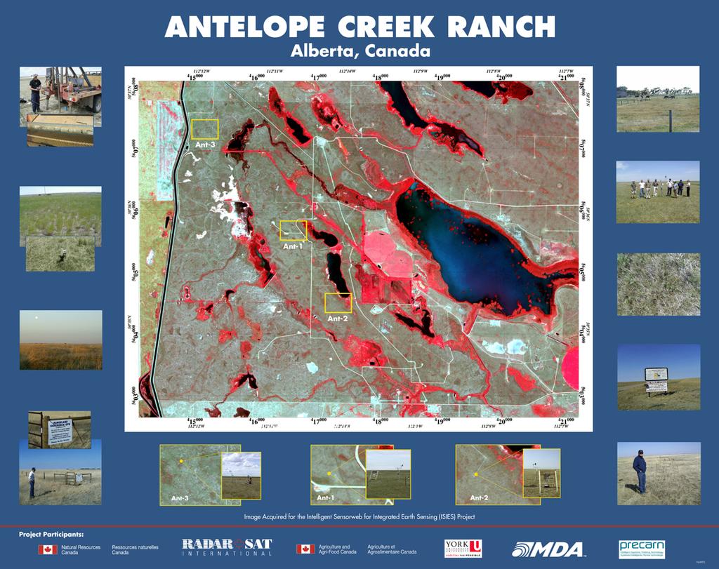


18 ISIES - Intelligent Sensorweb for Integrated Earth Sensing A Sensor Web for a better crop yielding prediction
19 A Farmer s s Virtual Globe: GeoSWIFT 1.0 for ISIES Project GeoSWIFT SW Viewer GeoSWIFT Sensor Web Server
20 A High Level Service Oriented View of the ISIES

21 All data from open standard-based geospatial web services Crop yielding prediction data from a SW processing service node Background satellite imagery from a OGC Web Mapping Service In-situ sensing data from a SW in-situ sensor service node

22 Emergency Agency s s Virtual Globe OGC Disaster Management Demo

23 Disaster scene identified

24 Flying to the area of interest

25 Displaying data from different sources

26

27 Discovering weather sensors

28

29 Connecting to Sensor Observation Server

30 Receiving Real-time Weather Data Streams
 for fire")
31 Sensor Planning Service (SPS) for fire scanner

32 Tasking UAV using Sensor Planning Service request is feasible

33 What s s happening behind the SPS interface Image courtesy of Phillip C. Dibner, NASA Ames Research Centre

34 SPS sent an e to requester
 data over")
35 SPS Results: UAV swath over Digital Raster Graphics (DRG) data over terrain
36 Discovering Web Cameras
37 Submitting Sensor Task and Receive Task ID

38 Sensor Observation Server for Chemical Disaster

39 Chemical Sensor Observation

40 TML Camera in Warehouse
41 Now, we have the standard building blocks to build an interoperable SW Through Web Service and OGC Standards We can connect heterogeneous sensor networks together. Because we re capable of connecting many sensors There will be lots and lots of sensors joining in this SW. New Challenge: Scalability What if we have millions of SW Servers??
 BTW, Interoperability is not considered in the current design of Sensor Map architecture.")
42 Directory-based Sensor Web Service: MSR Sensor Map Use a similar central directory-based architecture Not Reliable: Has single point of failure Not Load Balanced: All system load added to the central registry Not Flexible: What if sensor owners don t want to publish to the company hosting the service?? (e.g., Google) BTW, Interoperability is not considered in the current design of Sensor Map architecture. Registry Client Services Microsoft Research, 2006
43 GeoSWIFT 2.0 High Level Architecture A P2P Architecture: Nodes leverage each others resources to <GetObservation> provide <observedproperty>urn:ssw:def:phenomenon:airtemperature</observedproperty> the service. Reliable: <featureofinterest> No single point of failure <ogc:bbox> Load <gml:envelope> Balanced: Able to distribute the system load <gml:lowercorner> </gml:lowercorner> Flexibility: not controlled by a single organization <gml:uppercorner> </gml:uppercorner> P2P </gml:envelope> systems have been proven scalable. </ogc:bbox> Interoperable </featureofinterest> </GetObservation> GeoSWIFT 2.0 <ObservationCollection> <observation>. </observation> <observation>. </observation>.. </ObservationCollection> System composed by peer nodes
44 Some projects in progress


45 Cyberinfrastructure and Environmental Informatics for Monitoring Biogeoscience Process in the Rockies and Foothills


46 Wiki-Campus (or Wiki-City?) A human participating Sensor Web + +
47 A stream-based publish/subscribe Spatial Sensor Web Remote Sensors Stream-based Spatial Query Processing, in-network aggregate, filtering, and compress data streams while the data moving along the path from sensors to applications. P2P Geographically-based Publish/Subscribe Architecture Enable subscription of events within areas-of-interest and real-time event notification publish Sensor Networks publish aggregate filter notify publish subscribe Sensor Web Client P2P-based Sensor Discovery Service: use a P2P-based cooperative model to discover sensing resources according to geospatial constraints. Interoperable OGC Sensor Web Standards Interoperable Web Service Interfaces and information models for the SSW

48 Cloud Computing for Geospatial Data and Services
49 Some of my thoughts about Sensor Web and Virtual Globe


 Time")
50 The Trend of Computer Architecture: Faster, Smaller, Numerous Bell s Law (Gordon Bell, 1972) New computing class every 10 years log (people per computer) Time (Polastre, 2004)


51 Sensor Web as the medium between your First Earth to Second Earth If you spend more time in your second life, your first life become your first life.
52 What s s needed Easy to install Plug and Play Click to Install Easy to publish Think about blogging (slogging? publishing their own sensors) Easy to be discovered Ability of processing real-time data streams Alert!! Subscribe Skype, Napster, Kazza, etc.
53 Thank you!! Dr. Steve Liang Department of Geomatics Engineering Schulich School of Engineering University of Calgary
A NEW PEER-TO-PEER-BASED INTEROPERABLE SPATIAL SENSOR WEB ARCHITECTURE
 A NEW PEER-TO-PEER-BASED INTEROPERABLE SPATIAL SENSOR WEB ARCHITECTURE S.H.L. Liang Department of Geomatics Engineering, University of Calgary, Calgary, Alberta, CANADA T2N 1N4 steve.liang@ucalgary.ca
Web Service Interface. Dr. Simon Jirka
 1 Web Service Interface Standards Dr. Simon Jirka Overview 2 Providing Access to Observation Data OGC Sensor Observation Service Controlling Sensors OGC Sensor Planning Service Event Notification SOS 3
Extension of INSPIRE Download Services TG for Observation Data
 Extension of INSPIRE Download Services TG for Observation Data Simon Jirka (52 North) 14 th June 2014, MIG Workshop on WCS-based INSPIRE Download Services Agenda Motivation Sensor Web Proposed Update for
Sensor Data Management
 Wright State University CORE Scholar Kno.e.sis Publications The Ohio Center of Excellence in Knowledge- Enabled Computing (Kno.e.sis) 8-14-2007 Sensor Data Management Cory Andrew Henson Wright State University
GeoSensor Web Lab Connect, Share, and Use World-wide Sensors
 GeoSensor Web Lab Connect, Share, and Use World-wide Sensors Temperature: 30 C Humidity: 30% Windspeed: 12 km/h CO: 0.25 ppm NO: 0.27 ppm PM 2.5: 14 µg/m3 Temperature: 29 C Humidity: 29% Windspeed: 11
Mir Abolfazl Mostafavi Centre for research in geomatics, Laval University Québec, Canada
 Mir Abolfazl Mostafavi Centre for research in geomatics, Laval University Québec, Canada Mohamed Bakillah and Steve H.L. Liang Department of Geomatics Engineering University of Calgary, Alberta, Canada
EXTRA Examples of OGC standards in support of health applications
 EXTRA Examples of OGC standards in support of health applications Some prior / existing initiatives using OGC Standards EU INSPIRE (health and safety working group) GEOSS AIP, EO2Heaven project: EO2HEAVEN
Getting Started with ArcGIS for Server. Charmel Menzel and Ken Gorton
 Getting Started with ArcGIS for Server Charmel Menzel and Ken Gorton Agenda What is ArcGIS for Server? Types of Web services Publishing resources onto the Web Clients to ArcGIS for Server Editions and
Service Oriented Architecture
 Service Oriented Architecture Web Services Security and Management Web Services for non-traditional Types of Data What are Web Services? Applications that accept XML-formatted requests from other systems
Oracle Spatial User Conference! May 19, 2011 Ronald Reagan Building and International Trade Center Washington, DC USA
 ! May 19, 2011 Ronald Reagan Building and International Trade Center Washington, DC USA Matt McCue Application Architect/Developer Woolpert Inc. Joseph Seppi Program Manager Woolpert Inc. Challenges and
A Hybrid Peer-to-Peer Architecture for Global Geospatial Web Service Discovery
 A Hybrid Peer-to-Peer Architecture for Global Geospatial Web Service Discovery Shawn Chen 1, Steve Liang 2 1 Geomatics, University of Calgary, hschen@ucalgary.ca 2 Geomatics, University of Calgary, steve.liang@ucalgary.ca
Leveraging OGC Services in ArcGIS Server. Satish Sankaran, Esri Yingqi Tang, Esri
 Leveraging OGC Services in ArcGIS Server Satish Sankaran, Esri Yingqi Tang, Esri GIS Creating and Managing Geo Information Products - Proprietary - Open Specifications - Standards Dissemination of Geo
A Study of Mountain Environment Monitoring Based Sensor Web in Wireless Sensor Networks
 , pp.96-100 http://dx.doi.org/10.14257/astl.2014.60.24 A Study of Mountain Environment Monitoring Based Sensor Web in Wireless Sensor Networks Yeon-Jun An 1, Do-Hyeun Kim 2 1,2 Dept. of Computing Engineering
3D in the ArcGIS Platform. Chris Andrews
 3D in the ArcGIS Platform Chris Andrews Geospatial 3D is already all around us 3D is expanding the GIS community s opportunity to provide value 3D City & Infrastructure Models Generated 3D features Photogrammetrc
LogicGeoObject: a Client-Side Architectural Model for Aggregating Geospatial Dynamics from Sensor Web
 LogicGeoObject: a Client-Side Architectural Model for Aggregating Geospatial Dynamics from Sensor Web Xuelin He 1, Jeremy G. Morley 2 1 Department of Civil, Environmental & Geomatic Engineering, University
A Review for Semantic Sensor Web Research and Applications
 , pp.31-36 http://dx.doi.org/10.14257/astl.2014.48.06 A Review for Semantic Sensor Web Research and Applications Chaoqun Ji, Jin Liu, Xiaofeng Wang College of Information Engineering, Shanghai Maritime
Open Geospatial Consortium Inc.
 Open Geospatial Consortium Inc. Date: 2010-08-27 Reference number of this document: OGC XXXX OGC name of this OGC project document: XXXXXX Version: 1.0.0 Category: Discussion Paper Editor: SOS Usage Profile
The Canadian CyberSKA Project
 The Canadian CyberSKA Project A. G. Willis (on behalf of the CyberSKA Project Team) National Research Council of Canada Herzberg Institute of Astrophysics Dominion Radio Astrophysical Observatory May 24,
A Sensor Data Mediator Bridging the OGC Sensor Observation Service (SOS) and the OASIS Open Data Protocol (OData)
 and the OASIS Open Data Protocol (OData)") A Sensor Data Mediator Bridging the OGC Sensor Observation Service (SOS) and the OASIS Open Data Protocol (OData) Chih-Yuan Huang 1, Steve Liang 1, and Yan Xu 2 1 Department of Geomatics Engineering, University
A Sensor Data Mediator Bridging the OGC Sensor Observation Service (SOS) and the OASIS Open Data Protocol (OData) Chih-Yuan Huang 1, Steve Liang 1, and Yan Xu 2 1 Department of Geomatics Engineering, University
The Common Framework for Earth Observation Data. US Group on Earth Observations Data Management Working Group
 The Common Framework for Earth Observation Data US Group on Earth Observations Data Management Working Group Agenda USGEO and BEDI background Concise summary of recommended CFEOD standards today Full document
INTEGRATION OF DISASTER EVENT DATA INTO SPATIAL DATA INFRASTRUCTURES
 INTEGRATION OF DISASTER EVENT DATA INTO SPATIAL DATA INFRASTRUCTURES B. Stollberg a, *, T. De Groeve a, A. Hirner a, L. Vernaccini a, S. Paris a a Joint Research Centre of the European Commission, Institute
GEOSPATIAL ERDAS APOLLO. Your Geospatial Business System for Managing and Serving Information
 GEOSPATIAL ERDAS APOLLO Your Geospatial Business System for Managing and Serving Information ERDAS APOLLO Do you have large volumes of data, a geographicallydistributed user base and rapidly changing
Introduction to ThingWorx
 Introduction to ThingWorx Introduction to Internet of Things (2min) What are the objectives of this video? Figure 1 Welcome to ThingWorx (THWX), in this short video we will introduce you to the main components
Handbook of Research on Developments and Trends in Wireless Sensor Networks: From Principle to Practice
 Handbook of Research on Developments and Trends in Wireless Sensor Networks: From Principle to Practice Hai Jin Huazhong University of Science and Technology, China Wenbin Jiang Huazhong University of
Cloud Based IoT Application Provisioning (The Case of Wireless Sensor Applications)
") Cloud Based IoT Application Provisioning (The Case of Wireless Sensor Applications) (ENCS 691K Chapter 7) Roch Glitho, PhD Associate Professor and Canada Research Chair My URL - http://users.encs.concordia.ca/~glitho/
Cloud Based IoT Application Provisioning (The Case of Wireless Sensor Applications) (ENCS 691K Chapter 7) Roch Glitho, PhD Associate Professor and Canada Research Chair My URL - http://users.encs.concordia.ca/~glitho/
EarthCube and Cyberinfrastructure for the Earth Sciences: Lessons and Perspective from OpenTopography
 EarthCube and Cyberinfrastructure for the Earth Sciences: Lessons and Perspective from OpenTopography Christopher Crosby, San Diego Supercomputer Center J Ramon Arrowsmith, Arizona State University Chaitan
Proposed update of Technical Guidance for INSPIRE Download services based on SOS
 Proposed update of Technical Guidance for INSPIRE Download services based on SOS Organised by: Simon Jirka, Alexander Kotsev, Michael Lutz Dr. Simon Jirka (jirka@52north.org) 52 North GmbH Workshop - The
Cloud Computing and Cloud Networking
 Cloud Computing and Cloud Networking Dr. Adel Nadjaran Toosi Cloud Computing and Distributed Systems (CLOUDS) Laboratory, School of Computing and Information Systems The University of Melbourne, Australia
Introduction to INSPIRE. Network Services
 Introduction to INSPIRE. Network Services European Commission Joint Research Centre Institute for Environment and Sustainability Digital Earth and Reference Data Unit www.jrc.ec.europa.eu Serving society
REST INTERFACE FOR PUB/SUB
 REST INTERFACE FOR PUB/SUB Design and Practical Examples Matthes Rieke AGILE 2017 Workshop Event-based Dissemination and Processing of Geospatial Information Wageningen, 2017-05-09 1. PubSub Concepts 2.
Monitoring the Environment with Sensor Web Services
 EnviroInfo 2009 (Berlin) Environmental Informatics and Industrial Environmental Protection: Concepts, Methods and Tools Monitoring the Environment with Sensor Web Services Simon Jirka 1, Dr. Albert Remke
Service-Based Universal Application Interface for Demand Response Energy Systems (UC Berkeley Project)
") Service-Based Universal Application Interface for Demand Response Energy Systems (UC Berkeley Project) Goal: Develop and demonstrate an application development environment for a scalable and extendible
Service-Based Universal Application Interface for Demand Response Energy Systems (UC Berkeley Project) Goal: Develop and demonstrate an application development environment for a scalable and extendible
Heterogeneous Missions Accessibility: Interoperability for Earth Observation
 Heterogeneous Missions Accessibility: Interoperability for Earth Observation Pier Giorgio Marchetti - European Space Agency pier.giorgio.marchetti@esa.int Slide 1 EO missions Earth Explorer Global Challenges
for Sensor Overlay Network
 APAN 29 th Meeting - Sensor Network Workshop Toward a Federated Framework for Sensor Overlay Network Susumu Takeuchi National Institute of Information and Communications Technology (NICT), Japan Agenda
ISTSOS: INVESTIGATION OF THE SENSOR OBSERVATION SERVICE
 ISTSOS: INVESTIGATION OF THE SENSOR OBSERVATION SERVICE M. Cannata a, *, M. Antonovic a a Institute of Earth sciences, Dept. of Environment, Constructions and Design, University of Applied Sciences of
The Semantic Sensor Network Ontology A Generic Language to Describe Sensor Assets
 Ben Ridge Road Weather Station, South Esk River Catchment, Tasmania The Semantic Sensor Network Ontology A Generic Language to Describe Sensor Assets Holger Neuhaus Michael Compton Commonwealth Scientific
Enrichment of Sensor Descriptions and Measurements Using Semantic Technologies. Student: Alexandra Moraru Mentor: Prof. Dr.
 Enrichment of Sensor Descriptions and Measurements Using Semantic Technologies Student: Alexandra Moraru Mentor: Prof. Dr. Dunja Mladenić Environmental Monitoring automation Traffic Monitoring integration
Using the OGC SOS as INSPIRE Download Service for Observation Data
 Using the OGC SOS as INSPIRE Download Service for Observation Data Simon Jirka (52 North) Alexander Kotsev (JRC) Michael Lutz (JRC) Matthes Rieke (52 North) Robin Smith (JRC) Paul Smits (JRC) 18 th June
Semantic web based Sensor Planning Services (SPS) for Sensor Web Enablement (SWE)
 for Sensor Web Enablement (SWE)") Semantic web based Sensor Planning Services (SPS) for Sensor Web Enablement (SWE) P.Udayakumar 1, M.Indhumathi 2 1 Teaching Fellow,Department of Computer Technology, MIT Campus, Anna University Chennai,
Semantic web based Sensor Planning Services (SPS) for Sensor Web Enablement (SWE) P.Udayakumar 1, M.Indhumathi 2 1 Teaching Fellow,Department of Computer Technology, MIT Campus, Anna University Chennai,
Desarrollo de una herramienta de visualización de datos oceanográficos: Modelos y Observaciones
 Desarrollo de una herramienta de visualización de datos oceanográficos: Modelos y Observaciones J. Fernandez, J. Lopez, I. Carlos, F. Jerez, F. Hermosilla, M. Espino SIMO, LIM-UPC, CIIRC FIELD_AC 7 th
Lesson 1 Key-Terms Meanings: Web Connectivity of Devices and Devices Network
 Lesson 1 Key-Terms Meanings: Web Connectivity of Devices and Devices Network 1 Application Application: A software (S/W) for an application, such as, creating and sending an SMS, measuring and sending
A Study of Open Middleware for Wireless Sensor Networks
 , pp.105-109 http://dx.doi.org/10.14257/astl.2014.60.26 A Study of Open Middleware for Wireless Sensor Networks Chen-Nam 1, Do-Hyeun Kim 2 1,2 Dept. of Computing Engineering Jeju National University Jeju-Si
HANDLING PUBLICLY GENERATED AIR QUALITY DATA PETE TENEBRUSO & MIKE MATSKO MARCH 8 TH, 2017
 HANDLING PUBLICLY GENERATED AIR QUALITY DATA PETE TENEBRUSO & MIKE MATSKO MARCH 8 TH, 2017 EXAMPLES OF DEP DATA AND CROWDSOURCING Storm Readiness Beach Assessments Park Closings Emergency Management Social
Clouds and Things. Implications of the Cloud and Internet-of-Things for SCADA/ICS. April 25, 2018
 Clouds and Things Implications of the Cloud and Internet-of-Things for SCADA/ICS April 25, 2018 Agenda for this presentation Overview of the Cloud, Fog & Internet-of-Things IoT device capabilities IoT
Wireless Sensor Architecture GENERAL PRINCIPLES AND ARCHITECTURES FOR PUTTING SENSOR NODES TOGETHER TO
 Wireless Sensor Architecture 1 GENERAL PRINCIPLES AND ARCHITECTURES FOR PUTTING SENSOR NODES TOGETHER TO FORM A MEANINGFUL NETWORK Mobile ad hoc networks Nodes talking to each other Nodes talking to some
Introduction to SDIs (Spatial Data Infrastructure)
") www.grid.unep.ch Regional training workshop on geographical information system for energy planning Introduction to SDIs (Spatial Data Infrastructure) Dakar, 12 August 2014 Gregory Giuliani Andrea de Bono,
www.grid.unep.ch Regional training workshop on geographical information system for energy planning Introduction to SDIs (Spatial Data Infrastructure) Dakar, 12 August 2014 Gregory Giuliani Andrea de Bono,
Smart Dust : Dispersed, Un-tethered Geospatial Monitoring. Dr. Raja R. Kadiyala Chief Technology Officer CH2M HILL - Oakland, CA
 Smart Dust : Dispersed, Un-tethered Geospatial Monitoring Dr. Raja R. Kadiyala Chief Technology Officer CH2M HILL - Oakland, CA raja@ch2m.com Drivers and Trends Sensing, Communication and Computation MEMS
Big Data Earth Observation Standardization elements Codrina Ilie TERRASIGNA TF7/SG5
 Big Data Earth Observation Standardization elements Codrina Ilie TERRASIGNA TF7/SG5 1 Earth Observation standardization intro 2 directions: 1. standardization of the Ground Segment Services: Heterogeneous
Distributed Systems Architectures. Ian Sommerville 2006 Software Engineering, 8th edition. Chapter 12 Slide 1
 Distributed Systems Architectures Ian Sommerville 2006 Software Engineering, 8th edition. Chapter 12 Slide 1 Objectives To explain the advantages and disadvantages of different distributed systems architectures
IMAGERY FOR ARCGIS. Manage and Understand Your Imagery. Credit: Image courtesy of DigitalGlobe
 IMAGERY FOR ARCGIS Manage and Understand Your Imagery Credit: Image courtesy of DigitalGlobe 2 ARCGIS IS AN IMAGERY PLATFORM Empowering you to make informed decisions from imagery and remotely sensed data
Understanding ArcGIS Online - why organizations should embrace the cloud now
 Understanding ArcGIS Online - why organizations should embrace the cloud now Presented to: GeoAlberta - workshop Presented by: David Parry September 25, 2013 Today s Agenda Introduction - Why the Cloud?
MASAS. Overview & Backgrounder Document. Consultation Package. CanOps
 CanOps Overview & Backgrounder Document Consultation Package Defining CanOpS Multi-Agency Situational Awareness System () is a national information aggregation system that facilitates sharing situational
Wireless Sensor Networks --- Concepts and Challenges
 Wireless Sensor Networks --- Concepts and Challenges Outline Basic Concepts Applications Characteristics and Challenges 2 1 Basic Concepts Traditional Sensing Method Wired/Wireless Object Signal analysis
2/9/2016. Session Agenda: Implementing new Geospatial Technologies for more efficient data capture
 Implementing new Geospatial Technologies for more efficient data capture Jay Haskamp Applied Geospatial Engineer Steve Richter VP Sales Session Agenda: Today s changing technologies and what lies ahead
International Oceanographic Data and Information Exchange - Ocean Data Portal (IODE ODP)
") International Oceanographic Data and Information Exchange - Ocean Data Portal (IODE ODP) Enabling science through seamless and open access to marine data Credits This presentation was developed by: Mr.
International Oceanographic Data and Information Exchange - Ocean Data Portal (IODE ODP) Enabling science through seamless and open access to marine data Credits This presentation was developed by: Mr.
The API is dead. Long live the protocol.
 The API is dead. Long live the protocol. We need to add messaging to... Developers don't know who to trust or have a clear methodology. Messaging is complex and developers spend a lot of time
Video Architectures Eyes on the Future: The Benefits of Wireless Technology for Fixed Video Surveillance
 S O L U T I O N PA P E R Video Architectures Eyes on the Future: The Benefits of Wireless Technology for Fixed Video Surveillance Table of Contents Fixed Video Surveillance: The Big Three... 3 Wireless
GML, WFS and SVG: A New Frontier of Internet GIS
 GML, WFS and SVG: A New Frontier of Internet GIS Zhong-Ren Peng Director Center for Advanced Spatial Information Research Associate Professor Department of Urban Planning University of Wisconsin-Milwaukee
Motions from the 91st OGC Technical and Planning Committee Meetings Geneva, Switzerland Contents
 Motions from the 91st OGC Technical and Planning Committee Meetings Geneva, Switzerland Contents "The Open Geospatial Consortium and EarthCube White Paper... 2 Vote for OGC Sensor Observation Service 2.0
INSPIRE Download Service
 The OGC SOS as INSPIRE Download Service for (meteorological) l) Observation Data Simon Jirka (52 North) 29 th October 2014 5th Workshop on the use of GIS/OGC standards in meteorology Offenbach (Germany)
Reducing Consumer Uncertainty
 Spatial Analytics Reducing Consumer Uncertainty Towards an Ontology for Geospatial User-centric Metadata Introduction Cooperative Research Centre for Spatial Information (CRCSI) in Australia Communicate
GeoEvent Server: Introduction
 GeoEvent Server: Introduction Josh Joyner GeoEvent Server, Product Manager jjoyner@esri.com Sagar Ayare Real-Time GIS Product Engineer sayare@esri.com @thetechiesagar Agenda 1 2 3 4 5 What is Real-Time
Intelligent Enterprise meets Science of Where. Anand Raisinghani Head Platform & Data Management SAP India 10 September, 2018
 Intelligent Enterprise meets Science of Where Anand Raisinghani Head Platform & Data Management SAP India 10 September, 2018 Value The Esri & SAP journey Customer Impact Innovation Track Record Customer
Resource Discovery in IoT: Current Trends, Gap Analysis and Future Standardization Aspects
 Resource Discovery in IoT: Current Trends, Gap Analysis and Future Standardization Aspects Soumya Kanti Datta Research Engineer, EURECOM TF-DI Coordinator in W3C WoT IG Email: dattas@eurecom.fr Roadmap
Web Services for Geospatial Mobile AR
 Web Services for Geospatial Mobile AR Introduction Christine Perey PEREY Research & Consulting cperey@perey.com Many popular mobile applications already use the smartphone s built-in sensors and receivers
Using Databases for 3D Data Management From Point Cloud to City Model
 Using Databases for 3D Data Management From Point Cloud to City Model Hans Viehmann 1 1 ORACLE Corporation, Server Technologies Division, Hamburg, Germany, hans.viehmann@oracle.com Abstract With the cost
Jeffery S. Horsburgh. Utah Water Research Laboratory Utah State University
 Advancing a Services Oriented Architecture for Sharing Hydrologic Data Jeffery S. Horsburgh Utah Water Research Laboratory Utah State University D.G. Tarboton, D.R. Maidment, I. Zaslavsky, D.P. Ames, J.L.
SEXTANT 1. Purpose of the Application
 SEXTANT 1. Purpose of the Application Sextant has been used in the domains of Earth Observation and Environment by presenting its browsing and visualization capabilities using a number of link geospatial
Common Architectural Styles & Patterns
 Common Architectural Styles & Patterns some we ve already kind of discussed model view controller blackboard client/server layered pipe-and-filter Lots of ways to classify all these Application Domain
DMT Disaster Management Tool. Mohammed Khider, Michael Angermann, Martin Frassl, Michael Lichtenstern German Aerospace Center (DLR)
") DMT Disaster Management Tool Mohammed Khider, Michael Angermann, Martin Frassl, Michael Lichtenstern German Aerospace Center (DLR) Overview of the space based solutions used in disaster management Satellite
DMT Disaster Management Tool Mohammed Khider, Michael Angermann, Martin Frassl, Michael Lichtenstern German Aerospace Center (DLR) Overview of the space based solutions used in disaster management Satellite
Tutorial International Standards. Web Map Server (WMS) & Web Feature Server (WFS) Overview
 & Web Feature Server (WFS) Overview") ISO/TC 211 17 th Plenary & Associated Meetings Berlin, Germany, DIN Institute / 2003-10-31 Advisory Group on Outreach Tutorial International Standards Web Map Server (WMS) & Web Feature Server (WFS) Overview
ISO/TC 211 17 th Plenary & Associated Meetings Berlin, Germany, DIN Institute / 2003-10-31 Advisory Group on Outreach Tutorial International Standards Web Map Server (WMS) & Web Feature Server (WFS) Overview
Interoperability and Standards Supports in ArcGIS
 Esri International User Conference San Diego, California Technical Workshops July 26, 2012 Interoperability and Standards Supports in ArcGIS Satish Sankaran, Esri Yingqi Tang, Esri Agenda Esri s participation
Observation trends: Expectations from European Comission regarding data exchange and interoperability
 Observation trends: Expectations from European Comission regarding data exchange and interoperability Marcin Wichorowski (IO PAN), Sławomir Sagan (IO PAN), Declan Dunne (UCC MaREI), John Barton (UCC-TYNDALL)
Information-Centric IoT Platforms for City-Scale Deployments
 Information-Centric IoT Platforms for City-Scale Deployments Jiachen Chen WINLAB, Rutgers University, NJ, USA Email: jiachen@winlab.rutgers.edu Dec. 2, 2016 Information-Centric IoT Platforms for City-Scale
Core Embedded Systems
 Grand Challenges in Cyber Physical The Next Generation Tarek Abdelzaher Department of Computer Science University of Illinois at Urbana Champaign Core Core Challenges: Dependability Hardware/Software Co-Design
Reducing Consumer Uncertainty Towards a Vocabulary for User-centric Geospatial Metadata
 Meeting Host Supporting Partner Meeting Sponsors Reducing Consumer Uncertainty Towards a Vocabulary for User-centric Geospatial Metadata 105th OGC Technical Committee Palmerston North, New Zealand Dr.
THE ENVIRONMENTAL OBSERVATION WEB AND ITS SERVICE APPLICATIONS WITHIN THE FUTURE INTERNET Project introduction and technical foundations (I)
") ENVIROfying the Future Internet THE ENVIRONMENTAL OBSERVATION WEB AND ITS SERVICE APPLICATIONS WITHIN THE FUTURE INTERNET Project introduction and technical foundations (I) INSPIRE Conference Firenze,
ENVIROfying the Future Internet THE ENVIRONMENTAL OBSERVATION WEB AND ITS SERVICE APPLICATIONS WITHIN THE FUTURE INTERNET Project introduction and technical foundations (I) INSPIRE Conference Firenze,
Wireless Sensor Networks --- Concepts and Challenges
 Outline Wireless Sensor Networks --- Concepts and Challenges Basic Concepts Applications Characteristics and Challenges 2 Traditional Sensing Method Basic Concepts Signal analysis Wired/Wireless Object
Announcements. me your survey: See the Announcements page. Today. Reading. Take a break around 10:15am. Ack: Some figures are from Coulouris
 Announcements Email me your survey: See the Announcements page Today Conceptual overview of distributed systems System models Reading Today: Chapter 2 of Coulouris Next topic: client-side processing (HTML,
A Framework of Information Technology for Water Resources Management
 A Framework of Information Technology for Water Resources Management P.S.V.S. Sridhar T. N. Jowhar Wadia Institute of Himalyan Geology, Anant Bhaskar Garg U. Kedareswarudu ABSTRACT The use of the information
Novel System Architectures for Semantic Based Sensor Networks Integraion
 Novel System Architectures for Semantic Based Sensor Networks Integraion Z O R A N B A B O V I C, Z B A B O V I C @ E T F. R S V E L J K O M I L U T N O V I C, V M @ E T F. R S T H E S C H O O L O F T
Leveraging OGC Services in ArcGIS Server. Satish Sankaran Yingqi Tang
 Leveraging OGC Services in ArcGIS Server Satish Sankaran ssankaran@esri.com Yingqi Tang ytang@esri.com Agenda Interoperability Enablers OGC and esri OGC Web Services ArcGIS and OGC Web Services - @ version
Made in USA. ALPR-Catcher. Only 6 x 3.2 x 2. Add Automatic License Plate Recognition to IP Camera, DVR or NVR system via RTSP streaming.
 Add Automatic License Plate Recognition to IP Camera, DVR or NVR system via RTSP streaming. Scalable with Secure Cloud expandability. Yes, we can help with integration! Features: 1. ALPR OCR engine & Processing
Implementation Method of OGC Web Map Service Based on Web Service. Anthony Wenjue Jia *,Yumin Chen *,Jianya Gong * *Wuhan University
 Implementation Method of OGC Web Map Service Based on Web Service Anthony Wenjue Jia *,Yumin Chen *,Jianya Gong * *Wuhan University ABSTRACT The most important advantage of web service is the multi-platform,
Vortex Whitepaper. Simplifying Real-time Information Integration in Industrial Internet of Things (IIoT) Control Systems
 Control Systems") Vortex Whitepaper Simplifying Real-time Information Integration in Industrial Internet of Things (IIoT) Control Systems www.adlinktech.com 2017 Table of Contents 1. Introduction........ P 3 2. Iot and
Vortex Whitepaper Simplifying Real-time Information Integration in Industrial Internet of Things (IIoT) Control Systems www.adlinktech.com 2017 Table of Contents 1. Introduction........ P 3 2. Iot and
By Ashbindu Singh. Division of Early Warning & Assessment North America
 UNEP Global Environmental Alert Service By Ashbindu Singh United Nations Environment Programme Division of Early Warning & Assessment North America as@rona.unep.org Vision Vision: Mission: Goal: Everyone
Building Great Situational Awareness Apps Using ArcGIS Developer Tools. Kerry Robinson Eric Bader Thomas Solow
 Building Great Situational Awareness Apps Using ArcGIS Developer Tools Kerry Robinson Eric Bader Thomas Solow Agenda Situational Awareness in ArcGIS Developing apps in connected environments - ArcGIS Enterprise
Sensors & Transducers 2015 by IFSA Publishing, S. L.
 Sensors & Transducers 2015 by IFSA Publishing, S. L. http://www.sensorsportal.com Integrating Sensor Data Using Sensor Observation Service: Towards a Methodology for the O-Life Observatory 1, 3 Hicham
W3C Workshop on the Web of Things
 W3C Workshop on the Web of Things Enablers and services for an open Web of Devices 25 26 June 2014, Berlin, Germany Position Paper by Kheira Bekara, and Chakib Bekara - Centre de de Dveloppement des Technologies
DTV for Personalized Mobile Access and Unified Home Control
 DTV for Personalized Mobile Access and Unified Home Control Jianlin Guo, Fernando Matsubara, Johnas Cukier, Haosong Kong Mitsubishi Electric Research Labs, 558 Central Avenue, Murray Hill, NJ 07974, USA
IMS, NFV and Cloud-based Services BUILDING INTEGRATED CLOUD COMMUNICATION SERVICES
 Daitan White Paper IMS, NFV and Cloud-based Services BUILDING INTEGRATED CLOUD COMMUNICATION SERVICES Highly Reliable Software Development Services http://www.daitangroup.com Daitan Group 2014 IMS, NFV
Unified Service Access for Wireless Sensor Networks
 Unified Service Access for Wireless Sensor Networks Jukka Suhonen, Olli Kivelä, Teemu Laukkarinen, and Marko Hännikäinen Department of Computer Systems Tampere University of Technology Tampere, Finland
Knowledge Bases in Spatial Data Infrastructures A new Level of Decision Support
 Knowledge Bases in Spatial Data Infrastructures A new Level of Decision Support Ingo Simonis 1,Andreas W ytzisk 2 1 Institute for Geoinform atics,university of Muenster,Germ any Tel:+49-251-83-33084,Fax:
CSC8223 Wireless Sensor Networks. Chapter 3 Network Architecture
 CSC8223 Wireless Sensor Networks Chapter 3 Network Architecture Goals of this chapter General principles and architectures: how to put the nodes together to form a meaningful network Design approaches:
Unified Incident Command and Decision Support (UICDS) Bridging the Gap with Common Operational Data Through the UICDS Information Exchange Middleware
 Bridging the Gap with Common Operational Data Through the UICDS Information Exchange Middleware") Unified Incident Command and Decision Support (UICDS) Bridging the Gap with Common Operational Data Through the UICDS Information Exchange Middleware James W. Morentz, Ph.D. UICDS Outreach Director The
Unified Incident Command and Decision Support (UICDS) Bridging the Gap with Common Operational Data Through the UICDS Information Exchange Middleware James W. Morentz, Ph.D. UICDS Outreach Director The
Towards operational agility using service oriented integration of prototype and legacy systems
 Towards operational agility using service oriented integration of prototype and legacy systems Authors: Frank T. Johnsen, Trude H. Bloebaum, Ketil Lund, and Espen Skjervold Norwegian Defence Research Establishment
Geoffrey Fox Community Grids Laboratory Indiana University
 s of s of Simple Geoffrey Fox Community s Laboratory Indiana University gcf@indiana.edu s Here we propose a way of describing systems built from Service oriented s in a way that allows one to build new
Streamlining Lawful Intercept for WiMAX Networks
 White Paper Streamlining Lawful Intercept for WiMAX Networks f f Meet stringent lawful intercept requirements for monitoring WiMAX IP-based voice, data and multimedia traffic f f Comply with lawful intercept
Service Oriented Architecture For GIS Applications
 The 12 th International Conference of International Association for Computer Methods and Advances in Geomechanics (IACMAG) 1-6 October, 2008 Goa, India Service Oriented Architecture For GIS Applications
2 nd International Conference on Advances in Peer-to-Peer Systems (AP2PS) 2010
 2010") 2 nd International Conference on Advances in Peer-to-Peer Systems (AP2PS) 2010 Panel Discussion Professor Nick Antonopoulos School of Computing & Mathematics University of Derby Does P2P matter? P2P provides
2 nd International Conference on Advances in Peer-to-Peer Systems (AP2PS) 2010 Panel Discussion Professor Nick Antonopoulos School of Computing & Mathematics University of Derby Does P2P matter? P2P provides