Introduction to Lidar Technology and Data Collection
|
|
|
- Georgiana Washington
- 5 years ago
- Views:
Transcription
1 Introduction to Lidar Technology and Data Collection Christopher Crosby San Diego Supercomputer Center / OpenTopography (with content adapted from NCALM, David Phillips (UNVACO), Ian Madin (DOGAMI), Ralph Hagerud (USGS), and Dave Harding (NASA)) 2009 SCEC LiDAR Short Course: Using GeoEarthScope and B4 LiDAR data to analyze Southern California s active faults December 3-4, 2009


2 LIDAR / LiDAR / lidar / ALSM = light detection and ranging Billions of of accurate distance measurements with a laser rangefinder Distance is calculated by measuring the time that a laser pulse takes to travel to and from an object. Ian Madin, DOGAMI

3 Lidar data collection 1. Laser scanner 2. Inertial Measurement Unit (IMU) 3. GPS
4 Surface Point Spacing D. Phillips, UNAVCO Scan line spacing, swath width, spot size and overlap can all be defined as necessary to achieve target data to specification


5 Each laser pulse can produce multiple consecutive measurements from reflections off several surfaces in its path Ian Madin, DOGAMI Left = point cloud view of the tree in the photo on the right. Each point is colored by which return it was from a particular pulse: Red= 1 st Yellow = 2 nd Green = 3 rd


6 Lidar = Geodesy and signal processing D. Harding, NASA Point Cloud x n, y n, z n, i n
7 Typical Lidar Data Collection Parameters Aircraft: Cessna 337 Skymaster Personnel One pilot, one operator in plane GPS ground crew (2 to 10+ people) Scanner: Optech near-ir (Gemini) PRF: KHz Flying height: 600 1,000m AGL Flying speed: 120 mph Swath overlap: 50% nominal Ground truthing: GPS (campaign & CORS) Navigation solution: KARS Point spacing: sub-meter Nominal Accuracy (on open hard and flat surface) Vertical: 3 6 cm. Horizontal: cm.
8 Overall collection and deliverables workflow example from EarthScope Lidar 1. Planning (client / community) Target identification & prioritization Definition of data specification & deliverables 2. Collection (vendor) Additional GPS ground control? 3. Processing (vendor) Scanning laser, IMU, GPS solutions Point cloud generation Data classification Deliverable production
9 Overall collection and deliverables workflow II 3. Qa / Qc (Client) Visual inspection of data Ground control pts comparison Swath to swath consistency checks 4. Data delivery (vendor) Data arrives via hard drive or FTP This is the end of the line in many cases 5. Data distribution (client / 3 rd party) Data access levels vary dramatically More on online data access to lidar tomorrow
10 1. Lidar Acquisition Considerations Target identification and prioritization Defining collection scheme and data product requirements Tradeoffs concerning resolution vs. coverage GPS ground control requirements End use: geomorphology, geodesy, etc. Cost (B4 ~$500/sq.km., NoCal ~$400/sq.km., DV ~$300/ sq.km.) Seasonal constraints Leaf off, snow, heat, etc. Data volume lots of TB s yikes! Standard data products? Distribution scheme? D. Phillips, UNAVCO
11 2. Collection Generally discussed in previous slides
12 3. Processing GPS data processing and trajectory generation Kinematic software (KARS, TRACK, etc.) LiDAR range processing and XYZ point cloud generation Proprietary software (Terascan at present) Point cloud classification: Typically completed with proprietary software. Limited open source / free software available to do it yourself. Not fully automated significant manual intervention necessary.


13 Some thoughts on classification - courtesy of Ralph Hagerud, USGS 1 km all surveyed points Nookachamps Creek, east of Mount Vernon, Washington ground points identified by semi-automatic processing
14 What is ground? Ground is smooth despiking, iterative linear interpretation algorithms Ground is continuous (single-valued) No-multiples algorithm Ground is lowest surface in vicinity Block-minimum algorithms R. Hagerud, USGS
15 Ground is smooth despike algorithm 1. flag all points as ground 2. repeat: build TIN (triangulated irregular network) of ground points identify points that define strong positive curvatures flag identified points as not-ground 3. until no or few points are flagged R. Hagerud, USGS
16 Start with mixed ground and canopy returns (e.g. last-return data), build TIN R. Hagerud, USGS
17 Flag points that define spikes (strong convexities) R. Hagerud, USGS
18 Rebuild TIN R. Hagerud, USGS
19 Flag points that define spikes (strong convexities) R. Hagerud, USGS
20 Rebuild TIN R. Hagerud, USGS
21 Flag points that define spikes (strong convexities) R. Hagerud, USGS
22 Rebuild TIN R. Hagerud, USGS
23 Despike algorithm It works It s automatic Cheap(!) All assumptions explicit It can preserve breaklines It appears to retain more ground points than other algorithms R. Hagerud, USGS
24 Despike algorithm Problems: Removes some corners Sensitive to negative blunders Computationally intensive Makes rough surfaces Real? Measurement error? Misclassified vegetation? Cross-section of highway cut R. Hagerud, USGS
25 Ground is continuous (i.e., single-valued) No-multiples algorithm Multiple returns from pulse Single return from pulse R. Hagerud, USGS
26 No-multiples algorithms Fast Identify open areas Hopeless in woods R. Hagerud, USGS
27 Ground is lowest surface in vicinity block minimum algorithms Computationally rapid with raster processing Tweedy texture Biased low on slopes Appropriate block size is inversely proportional to penetration rate Requires human intervention to adjust block size Implicit assumption that ground is horizontal (Successful users of block-minimum algorithms work in flat places) R. Hagerud, USGS
28 In the real world Almost all return classification is done with proprietary codes Successful classification uses a mix of Sophisticated code Skilled human To adjust code parameters To identify and remedy problems Let somebody else do it! and then carefully check their work We have no useful metrics for accuracy of return classification R. Hagerud, USGS


29 4. Qa / Qc A QA protocol: 3 analyses Test against ground control Examine images of bare-earth surface model Evaluate internal consistency
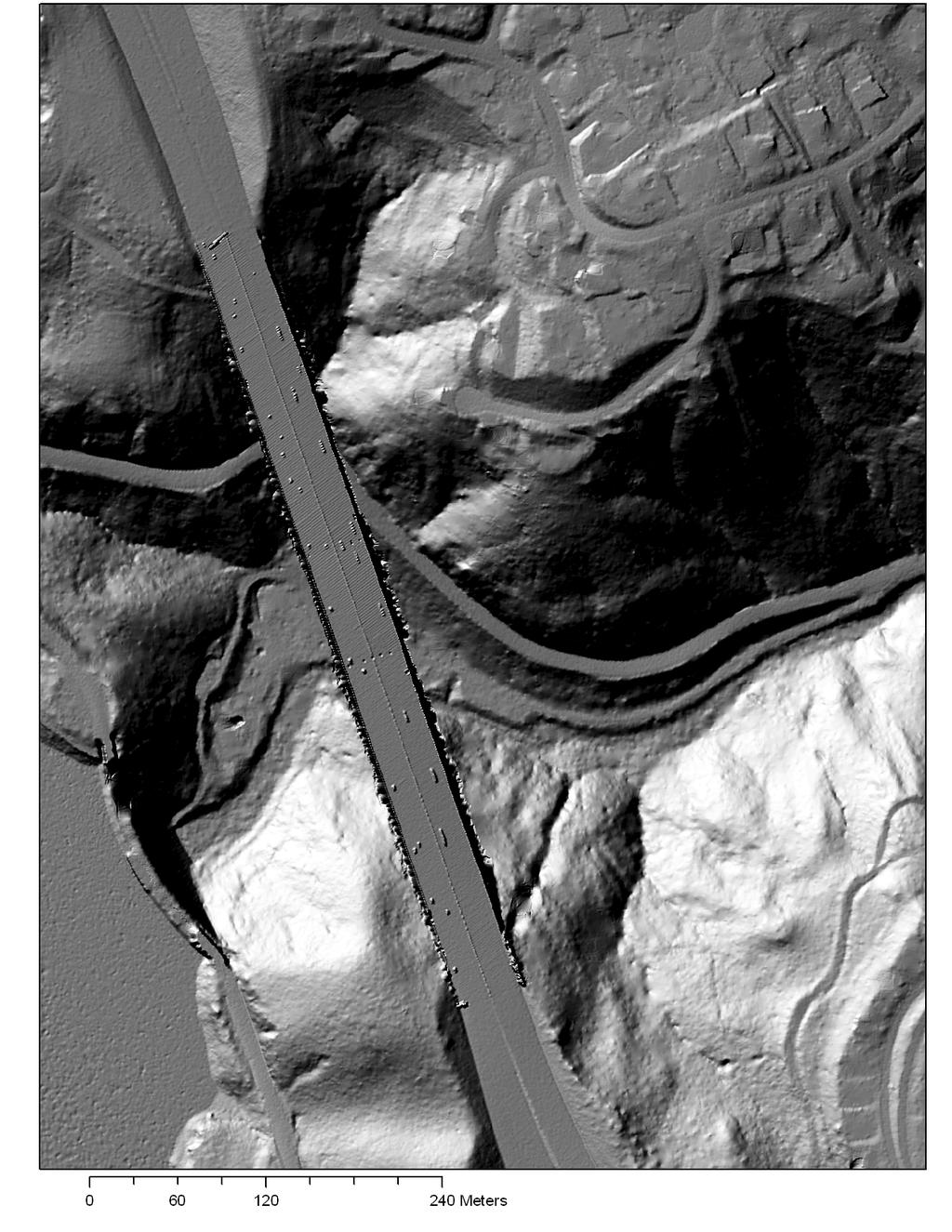
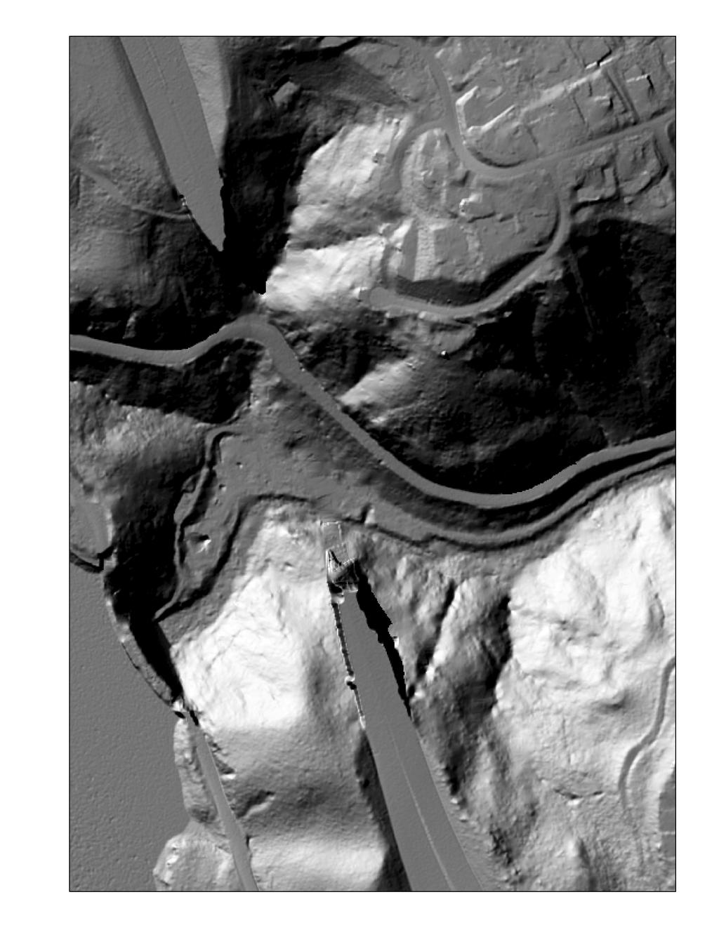
30
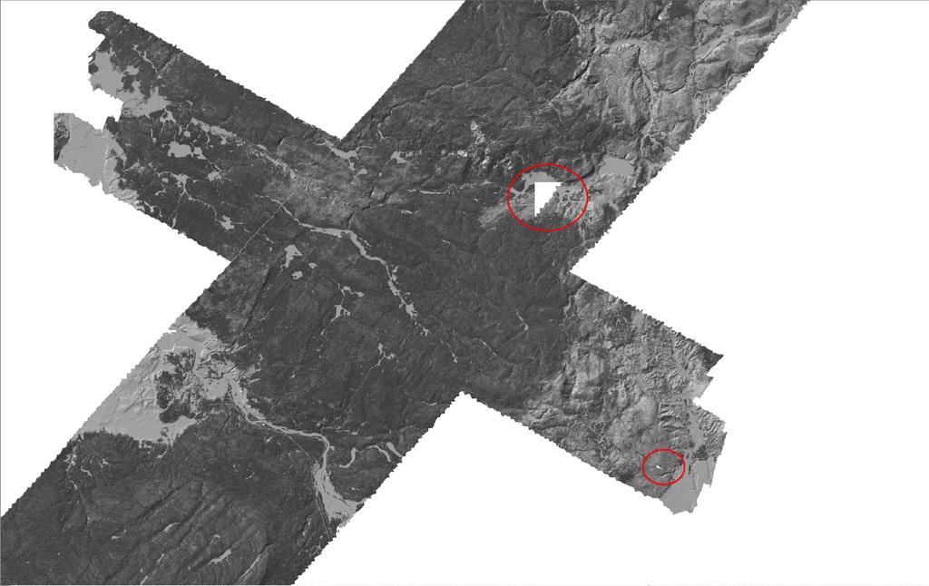
31


32 points scalped off bluff corners points scalped off corners Tileboundary artifacts corduroy Poor veg penetration, swath mismatch, bad point classification R. Hagerud, USGS
 Bare earth and first return DEMs")
 Metadata (FGDC if lucky) XML, machine readable Report of the survey")
33 5. Data Delivery Data typically arrives on HD from vendor. Deliverables: Point cloud (ascii or LAS) Bare earth and first return DEMs Data mosaics at lower resolution (e.g. 1 m vs 0.5 m) Metadata (FGDC if lucky) XML, machine readable Report of the survey PDF, human readable Point cloud Bare earth DEM
34 Deliverables - DEMs DEM Data: Bare earth and first return DEMs in tiles (1 km x 1 km, USGS ¼ quad) Hillshades of above DEMs (?) Mosaics at lower resolution (?) Intensity images (?) File Formats: No standards Common: Arc ESRI binary grid, ERDAS.IMG, GeoTiff, ascii grids, Surfer.grd, etc.
35 Deliverables Point Cloud X,Y,Z + attributes: Attributes: GPS time, Intensity / RGB, return #, classification (ground, vegetation, other), swath ID All return files: Organized into tiles (1 km x 1 km, subset of USGS ¼ quad) or by swath (USGS advocating this) File Formats: ASCII (.txt,.xyz) Easily parsed (linux painful on Windows), portable, HUGE, need to move to another format for on-the-fly analysis. x,y,z,gpstime,intensity,classification,flight_line , ,-14.54, ,5,2, , ,-14.04, ,5,1,9
36 Deliverables Point Cloud II File Formats: LAS (.las) Standard format (at v. 1.3) defined by ASPRS (American Society for Photography and Remote Sensing). Binary smaller, easily parsed and indexed with correct libraries (liblas) Standard Robust header Scanner info, processing software, spatial coordinates, bounding box, # of points in file Requires software that can read and write LAS More restrictive in terms of what attributes you can add LAS vs. fully populated LAS still need to output all the attribution Version 1.3 supports waveforms!
37
38 Deliverables Metadata Report of the Survey: PDF format (human readable) Data provider, area surveyed, when surveyed, instrument used, processing software and methods, spatial coordinates and datums, know issues, etc. Spatial reference framework Data provider s report on data quality Naming, formats, spatial organization of data files FGDC (or similar) metadata: - XML (machine readable) - Ideally populated by vendor and client - Not delivered by NCALM
39 5. Data distribution - Very little data makes it online - Access mechanisms vary - Who funds hosting of multi-tb datasets? More tomorrow AM
Mapping Project Report Table of Contents
 LiDAR Estimation of Forest Leaf Structure, Terrain, and Hydrophysiology Airborne Mapping Project Report Principal Investigator: Katherine Windfeldt University of Minnesota-Twin cities 115 Green Hall 1530
1. LiDAR System Description and Specifications
 High Point Density LiDAR Survey of Mayapan, MX PI: Timothy S. Hare, Ph.D. Timothy S. Hare, Ph.D. Associate Professor of Anthropology Institute for Regional Analysis and Public Policy Morehead State University
Exercise 1: Introduction to LiDAR Point Cloud Data using the Fusion Software Package
 Exercise 1: Introduction to LiDAR Point Cloud Data using the Fusion Software Package Christopher Crosby, San Diego Supercomputer Center / OpenTopography (Adapted from tutorial by Ian Madin, DOGAMI) Last
LiDAR sensor and system capabilities and issues
 LiDAR sensor and system capabilities and issues Ken Hudnut (USGS), Mike Bevis (OSU) & Adrian Borsa (UNAVCO) Using B4 and EarthScope LiDAR Data to Analyze Southern California s Active Faults December 3,
Simulating Dynamic Hydrological Processes in Archaeological Contexts Mapping Project Report
 Simulating Dynamic Hydrological Processes in Archaeological Contexts Mapping Project Report Principal Investigator: Wetherbee Dorshow University of New Mexico 15 Palacio Road Santa Fe, NM 87508 e-mail:
Phone: Fax: Table of Contents
 Geomorphic Characterization of Precarious Rock Zones LIDAR Mapping Project Report Principal Investigator: David E. Haddad Arizona State University ASU School of Earth and Space
Phone: (603) Fax: (603) Table of Contents
 Fax: (603) Table of Contents") Hydrologic and topographic controls on the distribution of organic carbon in forest Soils LIDAR Mapping Project Report Principal Investigator: Adam Finkelman Plumouth State University Plymouth State University,
Hydrologic and topographic controls on the distribution of organic carbon in forest Soils LIDAR Mapping Project Report Principal Investigator: Adam Finkelman Plumouth State University Plymouth State University,
Quantifying the Geomorphic and Sedimentological Responses to Dam Removal. Mapping Project Report
 Quantifying the Geomorphic and Sedimentological Responses to Dam Removal. Mapping Project Report January 21, 2011 Principal Investigator: John Gartner Dartmouth College Department of Earth Sciences Hanover,
Central Coast LIDAR Project, 2011 Delivery 1 QC Analysis LIDAR QC Report February 17 th, 2012
 O R E G O N D E P A R T M E N T O F G E O L O G Y A N D M I N E R A L I N D U S T R I E S OLC Central Coast Delivery 1 Acceptance Report. Department of Geology & Mineral Industries 800 NE Oregon St, Suite
Yosemite National Park LiDAR Mapping Project Report
 Yosemite National Park LiDAR Mapping Project Report Feb 1, 2011 Principal Investigator: Greg Stock, PhD, PG Resources Management and Science Yosemite National Park 5083 Foresta Road, PO Box 700 El Portal,
Sandy River, OR Bathymetric Lidar Project, 2012 Delivery QC Analysis Lidar QC Report March 26 th, 2013
 O R E G O N D E P A R T M E N T O F G E O L O G Y A N D M I N E R A L I N D U S T R I E S OLC Sandy River, OR Bathymetric Lidar Project Delivery Acceptance Report. Department of Geology & Mineral Industries
GeoEarthScope NoCAL San Andreas System LiDAR pre computed DEM tutorial
 GeoEarthScope NoCAL San Andreas System LiDAR pre computed DEM tutorial J Ramón Arrowsmith Chris Crosby School of Earth and Space Exploration Arizona State University ramon.arrowsmith@asu.edu http://lidar.asu.edu
BLM Fire Project, 2013 QC Analysis Lidar and Orthophoto QC Report November 25th, 2013
 O R E G O N D E P A R T M E N T O F G E O L O G Y 1937 A N D M I N E R A L I N D U S T R I E S Department of Geology & Mineral Industries 800 NE Oregon St, Suite 965 Portland, OR 97232 BLM Fire Project,
HAWAII KAUAI Survey Report. LIDAR System Description and Specifications
 HAWAII KAUAI Survey Report LIDAR System Description and Specifications This survey used an Optech GEMINI Airborne Laser Terrain Mapper (ALTM) serial number 06SEN195 mounted in a twin-engine Navajo Piper
Mapping Project Report Table of Contents
 Beavers as geomorphic agents in small, Rocky Mountain streams. Mapping Project Report Jan 27, 2011 Principal Investigator: Rebekah Levine Department of Earth and Planetary Sciences, MSCO3-2040,1 University
LiDAR & Orthophoto Data Report
 LiDAR & Orthophoto Data Report Tofino Flood Plain Mapping Data collected and prepared for: District of Tofino, BC 121 3 rd Street Tofino, BC V0R 2Z0 Eagle Mapping Ltd. #201 2071 Kingsway Ave Port Coquitlam,
LiDAR Remote Sensing Data Collection: Yaquina and Elk Creek Watershed, Leaf-On Acquisition
 LiDAR Remote Sensing Data Collection: Yaquina and Elk Creek Watershed, Leaf-On Acquisition Submitted by: 4605 NE Fremont, Suite 211 Portland, Oregon 97213 April, 2006 Table of Contents LIGHT DETECTION
An Introduction to Lidar & Forestry May 2013
 An Introduction to Lidar & Forestry May 2013 Introduction to Lidar & Forestry Lidar technology Derivatives from point clouds Applied to forestry Publish & Share Futures Lidar Light Detection And Ranging
Terrestrial GPS setup Fundamentals of Airborne LiDAR Systems, Collection and Calibration. JAMIE YOUNG Senior Manager LiDAR Solutions
 Terrestrial GPS setup Fundamentals of Airborne LiDAR Systems, Collection and Calibration JAMIE YOUNG Senior Manager LiDAR Solutions Topics Terrestrial GPS reference Planning and Collection Considerations
Studies. Reno, NV USA
 Data Collection and Processing Report forr 2015 Mapping Project of the Walker Fault System in Nevadaa PI: Steven G. Wesnousky Steven G. Wesnousky Professor of Geology and Seismology Director Center for
Managing Lidar and Photogrammetric Point Clouds. Lindsay Weitz Cody Benkelman
 and Photogrammetric Point Clouds Lindsay Weitz Cody Benkelman Presentation Context What is lidar, and how does it work? Not this presentation! What can you do with lidar in ArcGIS? What does Esri recommend
Enhanced Access to High-Resolution LiDAR Topography through Cyberinfrastructure-Based Data Distribution and Processing
 Enhanced Access to High-Resolution LiDAR Topography through Cyberinfrastructure-Based Data Distribution and Processing Christopher J. Crosby, J Ramón Arrowsmith Jeffrey Connor, Gilead Wurman Efrat Jaeger-Frank,
Burns, OR LIDAR Project, 2011 Delivery QC Analysis LIDAR QC Report February 13th, 2012
 O R E G O N D E P A R T M E N T O F G E O L O G Y A N D M I N E R A L I N D U S T R I E S OLC Burns, OR Delivery Acceptance Report. Department of Geology & Mineral Industries 800 NE Oregon St, Suite 965
Rogue River LIDAR Project, 2012 Delivery 1 QC Analysis LIDAR QC Report September 6 th, 2012
 O R E G O N D E P A R T M E N T O F G E O L O G Y A N D M I N E R A L I N D U S T R I E S OLC Rogue River Delivery 1 Acceptance Report. Department of Geology & Mineral Industries 800 NE Oregon St, Suite
Third Rock from the Sun
 Geodesy 101 AHD LiDAR Best Practice The Mystery of LiDAR Best Practice Glenn Jones SSSi GIS in the Coastal Environment Batemans Bay November 9, 2010 Light Detection and Ranging (LiDAR) Basic principles
Project Report Nooksack South Fork Lummi Indian Nation. Report Presented to:
 June 5, 2005 Project Report Nooksack South Fork Lummi Indian Nation Contract #2291-H Report Presented to: Lummi Indian Nation Natural Resources Department 2616 Kwina Road Bellingham, WA 98226 Point of
Aerial and Mobile LiDAR Data Fusion
 Creating Value Delivering Solutions Aerial and Mobile LiDAR Data Fusion Dr. Srini Dharmapuri, CP, PMP What You Will Learn About LiDAR Fusion Mobile and Aerial LiDAR Technology Components & Parameters Project
Technical Considerations and Best Practices in Imagery and LiDAR Project Procurement
 Technical Considerations and Best Practices in Imagery and LiDAR Project Procurement Presented to the 2014 WV GIS Conference By Brad Arshat, CP, EIT Date: June 4, 2014 Project Accuracy A critical decision
Airborne Laser Scanning: Remote Sensing with LiDAR
 Airborne Laser Scanning: Remote Sensing with LiDAR ALS / LIDAR OUTLINE Laser remote sensing background Basic components of an ALS/LIDAR system Two distinct families of ALS systems Waveform Discrete Return
Lewis County Public Works Department (County) GIS Mapping Division 350 N. Market Blvd. Chehalis, WA Phone: Fax:
 GIS Mapping Division 350 N. Market Blvd. Chehalis, WA Phone: Fax:") March 31, 2005 Project Report Lewis County, WA Contract #2262-H Report Presented to: Lewis County Public Works Department (County) GIS Mapping Division 350 N. Market Blvd. Chehalis, WA 98532-2626 Phone:
March 31, 2005 Project Report Lewis County, WA Contract #2262-H Report Presented to: Lewis County Public Works Department (County) GIS Mapping Division 350 N. Market Blvd. Chehalis, WA 98532-2626 Phone:
CLASSIFICATION OF NONPHOTOGRAPHIC REMOTE SENSORS
 CLASSIFICATION OF NONPHOTOGRAPHIC REMOTE SENSORS PASSIVE ACTIVE DIGITAL CAMERA THERMAL (e.g. TIMS) VIDEO CAMERA MULTI- SPECTRAL SCANNERS VISIBLE & NIR MICROWAVE HYPERSPECTRAL (e.g. AVIRIS) SLAR Real Aperture
Lidar Technical Report
 Lidar Technical Report Oregon Department of Forestry Sites Presented to: Oregon Department of Forestry 2600 State Street, Building E Salem, OR 97310 Submitted by: 3410 West 11st Ave. Eugene, OR 97402 April
Project Report Sauk-Suiattle Indian Tribe. Report Presented to:
 July 28, 2005 Project Report Sauk-Suiattle Indian Tribe Contract #2294-H Report Presented to: Sauk-Suiattle Indian Tribe 5318 Chief Brown Lane Darrington, WA 98241 Phone: (360) 436-0738 Fax: (360) 436-1092
LIDAR MAPPING FACT SHEET
 1. LIDAR THEORY What is lidar? Lidar is an acronym for light detection and ranging. In the mapping industry, this term is used to describe an airborne laser profiling system that produces location and
Project Report Lower Columbia River. Report Presented to:
 December 29, 2005 Project Report Lower Columbia River Contract #2265-H Report Presented to: Puget Sound Lidar Consortium 1011 Western Avenue, Suite 500 Seattle, WA 98104 Phone: (206) 464-7090 Fax: (206)
Quality Control Concepts for LiDAR
 Quality Control Concepts for LiDAR January 24, 2012 Engineering Architecture Design-Build Surveying GeoSpatial Solutions Presentation Objectives Offer realistic and constructive advice for LiDAR project
High resolution survey and orthophoto project of the Dosso-Gaya region in the Republic of Niger. by Tim Leary, Woolpert Inc.
 High resolution survey and orthophoto project of the Dosso-Gaya region in the Republic of Niger by Tim Leary, Woolpert Inc. Geospatial Solutions Photogrammetry & Remote Sensing LiDAR Professional Surveying
William E. Dietrich Professor 313 McCone Phone Fax (fax)
") February 13, 2007. Contact information William E. Dietrich Professor 313 McCone Phone 510-642-2633 Fax 510-643-9980 (fax) bill@eps.berkeley.edu Project location: Northwest of the Golden Gate Bridge, San
February 13, 2007. Contact information William E. Dietrich Professor 313 McCone Phone 510-642-2633 Fax 510-643-9980 (fax) bill@eps.berkeley.edu Project location: Northwest of the Golden Gate Bridge, San
Project Report Snohomish County Floodplains LiDAR Survey. Report Presented to:
 August 22, 2005 Project Report Snohomish County Floodplains LiDAR Survey Contract #2295-H Report Presented to: David Evans and Associates, Inc. (DEA) 1620 W. Marine View Drive, Suite 200 Everett, WA 98201
Quinnipiac Post Flight Aerial Acquisition Report
 Quinnipiac Post Flight Aerial Acquisition Report August 2011 Post-Flight Aerial Acquisition and Calibration Report FEMA REGION 1 Quinnipiac Watershed, Connecticut, Massachusesetts FEDERAL EMERGENCY MANAGEMENT
Up to 4 range measurements per pulse, including last 4 Intensity readings with 12-bit dynamic range for each measurement
 Project PI: Hugo A. Gutierrez Jurado 1. ALTM Specifications This survey used an Optech GEMINI Airborne Laser Terrain Mapper (ALTM) serial number 06SEN195 mounted in a twin-engine Cessna Skymaster (Tail
Reality Check: Processing LiDAR Data. A story of data, more data and some more data
 Reality Check: Processing LiDAR Data A story of data, more data and some more data Red River of the North Red River of the North Red River of the North Red River of the North Introduction and Background
Workshops funded by the Minnesota Environment and Natural Resources Trust Fund
 Workshops funded by the Minnesota Environment and Natural Resources Trust Fund Conservation Applications of LiDAR Data Workshops funded by: Minnesota Environment and Natural Resources Trust Fund Presented
Alaska Department of Transportation Roads to Resources Project LiDAR & Imagery Quality Assurance Report Juneau Access South Corridor
 Alaska Department of Transportation Roads to Resources Project LiDAR & Imagery Quality Assurance Report Juneau Access South Corridor Written by Rick Guritz Alaska Satellite Facility Nov. 24, 2015 Contents
Terrain Modeling and Mapping for Telecom Network Installation Using Scanning Technology. Maziana Muhamad
 Terrain Modeling and Mapping for Telecom Network Installation Using Scanning Technology Maziana Muhamad Summarising LiDAR (Airborne Laser Scanning) LiDAR is a reliable survey technique, capable of: acquiring
Lecture 23 - LiDAR. GEOL 452/552 - GIS for Geoscientists I. Scanning Lidar. 30 m DEM. Lidar representations:
 GEOL 452/552 - GIS for Geoscientists I Lecture 23 - LiDAR LiDAR - some background (thanks to Chris Kahle, DNR) Converting Lidar point data to a raster Look at online lidar data for Iowa (1m hillshaded)
Windstorm Simulation & Modeling Project
 Windstorm Simulation & Modeling Project Airborne LIDAR Data and Digital Elevation Models in Broward County, Florida Data Quality Report and Description of Deliverable Datasets Prepared for: The Broward
N.J.P.L.S. An Introduction to LiDAR Concepts and Applications
 N.J.P.L.S. An Introduction to LiDAR Concepts and Applications Presentation Outline LIDAR Data Capture Advantages of Lidar Technology Basics Intensity and Multiple Returns Lidar Accuracy Airborne Laser
LiDAR Technical Report NE Washington LiDAR Production 2017
 LiDAR Technical Report NE Washington LiDAR Production 2017 Presented to: Washington DNR 1111 Washington Street SE Olympia, Washington 98504 Submitted by: 860 McKinley St Eugene, OR 97402 July 26, 2017
Digital Elevation Models
 Digital Elevation Models National Elevation Dataset 1 Data Sets US DEM series 7.5, 30, 1 o for conterminous US 7.5, 15 for Alaska US National Elevation Data (NED) GTOPO30 Global Land One-kilometer Base
An Introduction to Using Lidar with ArcGIS and 3D Analyst
 FedGIS Conference February 24 25, 2016 Washington, DC An Introduction to Using Lidar with ArcGIS and 3D Analyst Jim Michel Outline Lidar Intro Lidar Management Las files Laz, zlas, conversion tools Las
Light Detection and Ranging (LiDAR)
") Light Detection and Ranging (LiDAR) http://code.google.com/creative/radiohead/ Types of aerial sensors passive active 1 Active sensors for mapping terrain Radar transmits microwaves in pulses determines
Light Detection and Ranging (LiDAR) http://code.google.com/creative/radiohead/ Types of aerial sensors passive active 1 Active sensors for mapping terrain Radar transmits microwaves in pulses determines
Up to 4 range measurements per pulse, including last 4 Intensity readings with 12-bit dynamic range for each measurement
 Contact information Greg Tucker Cooperative Institute for Research in Environmental Sciences (CIRES) Dept. of Geological Sciences University of Colorado Boulder, CO 80309-0399 303-492-6985 gtucker@cires.colorado.edu
SPAR, ELMF 2013, Amsterdam. Laser Scanning on the UK Highways Agency Network. Hamish Grierson Blom Uk
 SPAR, ELMF 2013, Amsterdam Laser Scanning on the UK Highways Agency Network Hamish Grierson Blom Uk www.blomasa.com www.blom-uk.co.uk Blom UK Part of the Blom Group Blom Group - Europe s largest aerial
GEON Points2Grid Utility Instructions By: Christopher Crosby OpenTopography Facility, San Diego Supercomputer Center
 GEON Points2Grid Utility Instructions By: Christopher Crosby (ccrosby@sdsc.edu) OpenTopography Facility, San Diego Supercomputer Center (Formerly: GEON / Active Tectonics Research Group School of Earth
Light Detection and Ranging (LiDAR) Radiohead House of Cards
 Radiohead House of Cards") Light Detection and Ranging (LiDAR) Radiohead House of Cards http://the-moni-blog.blogspot.com/2009/03/lidar-is-going-mainstream-mtv-baby.html h =? Laser Vision GPS + IMU θ H X a h Types of aerial sensors
Light Detection and Ranging (LiDAR) Radiohead House of Cards http://the-moni-blog.blogspot.com/2009/03/lidar-is-going-mainstream-mtv-baby.html h =? Laser Vision GPS + IMU θ H X a h Types of aerial sensors
Ground LiDAR fuel measurements of the Prescribed Fire Combustion and Atmospheric Dynamics Research Experiment
 Ground LiDAR fuel measurements of the Prescribed Fire Combustion and Atmospheric Dynamics Research Experiment Eric Rowell, Erik Apland and Carl Seielstad IAWF 4 th Fire Behavior and Fuels Conference, Raleigh,
Airborne LiDAR Data Acquisition for Forestry Applications. Mischa Hey WSI (Corvallis, OR)
") Airborne LiDAR Data Acquisition for Forestry Applications Mischa Hey WSI (Corvallis, OR) WSI Services Corvallis, OR Airborne Mapping: Light Detection and Ranging (LiDAR) Thermal Infrared Imagery 4-Band
Airborne LiDAR Data Acquisition for Forestry Applications Mischa Hey WSI (Corvallis, OR) WSI Services Corvallis, OR Airborne Mapping: Light Detection and Ranging (LiDAR) Thermal Infrared Imagery 4-Band
2010 LiDAR Project. GIS User Group Meeting June 30, 2010
 2010 LiDAR Project GIS User Group Meeting June 30, 2010 LiDAR = Light Detection and Ranging Technology that utilizes lasers to determine the distance to an object or surface Measures the time delay between
TLS Parameters, Workflows and Field Methods
 TLS Parameters, Workflows and Field Methods Marianne Okal, UNAVCO June 20 th, 2014 How a Lidar instrument works (Recap) Transmits laser signals and measures the reflected light to create 3D point clouds.
MARS v Release Notes Revised: May 23, 2018 (Builds and )
") MARS v2018.0 Release Notes Revised: May 23, 2018 (Builds 8302.01 8302.18 and 8350.00 8352.00) Contents New Features:... 2 Enhancements:... 6 List of Bug Fixes... 13 1 New Features: LAS Up-Conversion prompts
MARS v2018.0 Release Notes Revised: May 23, 2018 (Builds 8302.01 8302.18 and 8350.00 8352.00) Contents New Features:... 2 Enhancements:... 6 List of Bug Fixes... 13 1 New Features: LAS Up-Conversion prompts
Cooperating Technical Partners Information Exchange. LIDAR QA/QC and Extracting Building Footprints
 Cooperating Technical Partners Information Exchange LIDAR QA/QC and Extracting Building Footprints Audio and Web Settings Participation Open and hide your control panel using the orange arrow button at
LIDAR REMOTE SENSING DATA COLLECTION: DOGAMI, CAMP CREEK PROJECT AREA
 LIDAR REMOTE SENSING DATA COLLECTION DEPARTMENT OF GEOLOGY AND MINERAL INDUSTRIES CAMP CREEK, OREGON NOVEMBER 26, 2008 Submitted to: Department of Geology and Mineral Industries 800 NE Oregon Street, Suite
High Resolution Laserscanning, not only for 3D-City Models
 Lohr 133 High Resolution Laserscanning, not only for 3D-City Models UWE LOHR, Ravensburg ABSTRACT The TopoSys laserscanner system is designed to produce digital elevation models (DEMs) of the environment
OLC Wasco County: Delivery One.
 OLC Wasco County: Delivery One www.quantumspatial.com January 2, 2014 Trimble R7 Receiver set up over GPS monument WASCO_02. Data collected for: Oregon Department of Geology and Mineral Industries 800
Quality Assurance and Quality Control Procedures for Survey-Grade Mobile Mapping Systems
 Quality Assurance and Quality Control Procedures for Survey-Grade Mobile Mapping Systems Latin America Geospatial Forum November, 2015 Agenda 1. Who is Teledyne Optech 2. The Lynx Mobile Mapper 3. Mobile
Managing and Serving Elevation and Lidar Data. Cody Benkelman UC 2018
 Managing and Serving Elevation and Lidar Data Cody Benkelman UC 2018 Outline Usage Modes Data Management - Architecture - Workflow Automation for Repeatability & Scalability A few options Usage Modes of
NEXTMap World 10 Digital Elevation Model
 NEXTMap Digital Elevation Model Intermap Technologies, Inc. 8310 South Valley Highway, Suite 400 Englewood, CO 80112 10012015 NEXTMap (top) provides an improvement in vertical accuracy and brings out greater
LiDAR REMOTE SENSING DATA COLLECTION BISCUIT FIRE STUDY AREA, OREGON
 LiDAR REMOTE SENSING DATA COLLECTION BISCUIT FIRE STUDY AREA, OREGON Oblique view in the Biscuit Fire Study Area: Above Ground ESRI Grid (1-meter resolution) derived from all LiDAR points Submitted to:
NEXTMap World 30 Digital Surface Model
 NEXTMap World 30 Digital Surface Model Intermap Technologies, Inc. 8310 South Valley Highway, Suite 400 Englewood, CO 80112 083013v3 NEXTMap World 30 (top) provides an improvement in vertical accuracy
COMPONENTS. The web interface includes user administration tools, which allow companies to efficiently distribute data to internal or external users.
 COMPONENTS LASERDATA LIS is a software suite for LiDAR data (TLS / MLS / ALS) management and analysis. The software is built on top of a GIS and supports both point and raster data. The following software
Integrated Multi-Source LiDAR and Imagery
 Figure 1: AirDaC aerial scanning system Integrated Multi-Source LiDAR and Imagery The derived benefits of LiDAR scanning in the fields of engineering, surveying, and planning are well documented. It has
ALS40 Airborne Laser Scanner
 ALS40 Airborne Laser Scanner Airborne LIDAR for Professionals High Performance Laser Scanning Direct Measurement of Ground Surface from the Air The ALS40 Airborne Laser Scanner measures the topography
W D-0049/004 EN
 September 21, 2011 Contact Ground Survey Report, Lidar Accuracy Report, & Project Report New Madrid Seismic Zone Northeast of Memphis, Tennessee Contract Number: W91278-09D-0049/004 EN Project: C-10-026
Municipal Projects in Cambridge Using a LiDAR Dataset. NEURISA Day 2012 Sturbridge, MA
 Municipal Projects in Cambridge Using a LiDAR Dataset NEURISA Day 2012 Sturbridge, MA October 15, 2012 Jeff Amero, GIS Manager, City of Cambridge Presentation Overview Background on the LiDAR dataset Solar
QUESTIONS & ANSWERS FOR. ORTHOPHOTO & LiDAR AOT
 QUESTIONS & ANSWERS FOR ORTHOPHOTO & LiDAR AOT Question# 1. Section 3.2 Will the imagery be clipped to the 1000m boundary? If so, what color will be used for null valued pixels? Yes, the imagery will be
ArcGIS for Server Imagery Update. Cody A. Benkelman Technical Product Manager, Imagery
 ArcGIS for Server Imagery Update Cody A. Benkelman Technical Product Manager, Imagery Outline Mosaic dataset Management and dissemination of imagery - Dynamic image services, Tiled Cache Visualization
I. Project Title Light Detection and Ranging (LIDAR) Processing
 Processing") I. Project Title Light Detection and Ranging (LIDAR) Processing II. Lead Investigator Ryan P. Lanclos Research Specialist 107 Stewart Hall Department of Geography University of Missouri Columbia Columbia,
I. Project Title Light Detection and Ranging (LIDAR) Processing II. Lead Investigator Ryan P. Lanclos Research Specialist 107 Stewart Hall Department of Geography University of Missouri Columbia Columbia,
Title: Understanding Hyporheic Zone Extent and Exchange in a Coastal New Hampshire Stream Using Heat as A Tracer
 Contact information Danna Truslow d.truslow@comcast.net Phone: 603-498-2916 Fax: 603-430-9102 Address: 1065 Washington Road Rye, NH 03970 Advisor: Jennifer Jacobs Advisor's email: jennifer.jacobs@unh.edu
GEON LiDAR Workflow (GLW) Users Guide
 Users Guide") GEON LiDAR Workflow (GLW) Users Guide Joshua Coyan Christopher Crosby Ramón Arrowsmith School of Earth and Space Exploration Arizona State University 24 October 2007 http://lidar.asu.edu Table of Contents
GEON LiDAR Workflow (GLW) Users Guide Joshua Coyan Christopher Crosby Ramón Arrowsmith School of Earth and Space Exploration Arizona State University 24 October 2007 http://lidar.asu.edu Table of Contents
Data Integration in Building Virtual Models
 Data Integration in Building Virtual Models Erik Singels, Geospatial Information Sciences Program Brent Vollmar, Department of Geosciences Adewale Okunoren, Department of Geosciences Carlos L. V. Aiken,
Assimilation of Break line and LiDAR Data within ESRI s Terrain Data Structure (TDS) for creating a Multi-Resolution Terrain Model
 for creating a Multi-Resolution Terrain Model") Assimilation of Break line and LiDAR Data within ESRI s Terrain Data Structure (TDS) for creating a Multi-Resolution Terrain Model Tarig A. Ali Department of Civil Engineering American University of Sharjah,
Assimilation of Break line and LiDAR Data within ESRI s Terrain Data Structure (TDS) for creating a Multi-Resolution Terrain Model Tarig A. Ali Department of Civil Engineering American University of Sharjah,
Overview. 1. Aerial LiDAR in Wisconsin (20 minutes) 2. Demonstration of data in CAD (30 minutes) 3. High Density LiDAR (20 minutes)
 2. Demonstration of data in CAD (30 minutes) 3. High Density LiDAR (20 minutes)") Overview 1. Aerial LiDAR in Wisconsin (20 minutes) 2. Demonstration of data in CAD (30 minutes) 3. High Density LiDAR (20 minutes) 4. Aerial lidar technology advancements (15 minutes) 5. Q & A 1. Aerial
Overview 1. Aerial LiDAR in Wisconsin (20 minutes) 2. Demonstration of data in CAD (30 minutes) 3. High Density LiDAR (20 minutes) 4. Aerial lidar technology advancements (15 minutes) 5. Q & A 1. Aerial
Esri International User Conference. July San Diego Convention Center. Lidar Solutions. Clayton Crawford
 Esri International User Conference July 23 27 San Diego Convention Center Lidar Solutions Clayton Crawford Outline Data structures, tools, and workflows Assessing lidar point coverage and sample density
Lidar and GIS: Applications and Examples. Dan Hedges Clayton Crawford
 Lidar and GIS: Applications and Examples Dan Hedges Clayton Crawford Outline Data structures, tools, and workflows Assessing lidar point coverage and sample density Creating raster DEMs and DSMs Data area
A geoinformatics-based approach to the distribution and processing of integrated LiDAR and imagery data to enhance 3D earth systems research
 A geoinformatics-based approach to the distribution and processing of integrated LiDAR and imagery data to enhance 3D earth systems research Christopher J. Crosby, J Ramón Arrowsmith, Jeffrey Connor, Gilead
Lidar Sensors, Today & Tomorrow. Christian Sevcik RIEGL Laser Measurement Systems
 Lidar Sensors, Today & Tomorrow Christian Sevcik RIEGL Laser Measurement Systems o o o o Online Waveform technology Stand alone operation no field computer required Remote control through wireless network
A Method to Create a Single Photon LiDAR based Hydro-flattened DEM
 A Method to Create a Single Photon LiDAR based Hydro-flattened DEM Sagar Deshpande 1 and Alper Yilmaz 2 1 Surveying Engineering, Ferris State University 2 Department of Civil, Environmental, and Geodetic
LORI COLLINS, RESEARCH ASSOCIATE PROFESSOR CONTRIBUTIONS BY: RICHARD MCKENZIE AND GARRETT SPEED, DHHC USF L IBRARIES
 LORI COLLINS, RESEARCH ASSOCIATE PROFESSOR CONTRIBUTIONS BY: RICHARD MCKENZIE AND GARRETT SPEED, DHHC USF L IBRARIES AERIAL AND TERRESTRIAL SURVEY WORKFLOWS Workflow from project planning applications
LiDAR Data Processing:
 LiDAR Data Processing: Concepts and Methods for LEFI Production Gordon W. Frazer GWF LiDAR Analytics Outline of Presentation Data pre-processing Data quality checking and options for repair Data post-processing
AIRBORNE LIDAR TASK ORDER REPORT SHELBY COUNTY TN 1M NPS LIDAR/FEATURE EXTRACT TASK ORDER UNITED STATES GEOLOGICAL SURVEY (USGS)
") AIRBORNE LIDAR TASK ORDER REPORT SHELBY COUNTY TN 1M NPS LIDAR/FEATURE EXTRACT TASK ORDER UNITED STATES GEOLOGICAL SURVEY (USGS) CONTRACT NUMBER: G10PC00057 TASK ORDER NUMBER: G12PD00127 Woolpert Project
AIRBORNE LIDAR TASK ORDER REPORT SHELBY COUNTY TN 1M NPS LIDAR/FEATURE EXTRACT TASK ORDER UNITED STATES GEOLOGICAL SURVEY (USGS) CONTRACT NUMBER: G10PC00057 TASK ORDER NUMBER: G12PD00127 Woolpert Project
2017 OLC Silver Creek
 2017 OLC Silver Creek December 15, 2017 www.quantumspatial.com Data collected for: Oregon Department of Geology and Mineral Industries 800 NE Oregon Street Suite 965 Portland, OR 97232 Prepared by: Quantum
Introduction to LiDAR
 Introduction to LiDAR Our goals here are to introduce you to LiDAR data. LiDAR data is becoming common, provides ground, building, and vegetation heights at high accuracy and detail, and is available statewide.
LIDAR an Introduction and Overview
 LIDAR an Introduction and Overview Rooster Rock State Park & Crown Point. Oregon DOGAMI Lidar Project Presented by Keith Marcoe GEOG581, Fall 2007. Portland State University. Light Detection And Ranging
Orthophotography and LiDAR Terrain Data Collection Rogue River, Oregon Final Report
 Orthophotography and LiDAR Terrain Data Collection Rogue River, Oregon Final Report Prepared by Sky Research, Inc. 445 Dead Indian Memorial Road Ashland, OR 97520 Prepared for Rogue Valley Council of Governments
COMPUTING SOLAR ENERGY POTENTIAL OF URBAN AREAS USING AIRBORNE LIDAR AND ORTHOIMAGERY
 COMPUTING SOLAR ENERGY POTENTIAL OF URBAN AREAS USING AIRBORNE LIDAR AND ORTHOIMAGERY Ryan Hippenstiel The Pennsylvania State University John A. Dutton e-education Institute 2217 Earth & Engineering Sciences
Using LiDAR (Light Distancing And Ranging) data to more accurately describe avalanche terrain
 data to more accurately describe avalanche terrain") International Snow Science Workshop, Davos 009, Proceedings Using LiDAR (Light Distancing And Ranging) data to more accurately describe avalanche terrain Christopher M. McCollister, and Robert H. Comey,
International Snow Science Workshop, Davos 009, Proceedings Using LiDAR (Light Distancing And Ranging) data to more accurately describe avalanche terrain Christopher M. McCollister, and Robert H. Comey,
Northern California Fault System LiDAR Survey. (March 21 April 17, 2007) Processing Report
 Processing Report") Northern California Fault System LiDAR Survey (March 21 April 17, 2007) Processing Report Tables of Content 1. LIDAR SYSTEM DESCRIPTION AND SPECIFICATIONS...3 2. NOCAL FIELD CAMPAIGN...3 2.1 SURVEY PLANNING
Northern California Fault System LiDAR Survey (March 21 April 17, 2007) Processing Report Tables of Content 1. LIDAR SYSTEM DESCRIPTION AND SPECIFICATIONS...3 2. NOCAL FIELD CAMPAIGN...3 2.1 SURVEY PLANNING
Workflows for Managing and Serving Elevation (and Lidar) Data. Cody Benkelman
 Data. Cody Benkelman") Workflows for Managing and Serving Elevation (and Lidar) Data Cody Benkelman Outline Usage Modes Data Management - Architecture - Workflow Automation for Repeatability & Scalability A few options re: Cloud,
Workflows for Managing and Serving Elevation (and Lidar) Data Cody Benkelman Outline Usage Modes Data Management - Architecture - Workflow Automation for Repeatability & Scalability A few options re: Cloud,
MARS v Release Notes Revised: December 20, 2018 (Builds )
") MARS v2019.0 Release Notes Revised: December 20, 2018 (Builds 8399.00 8400.00) Contents New Features:... 2 Enhancements:... 2 List of Bug Fixes... 7 1 STATEMENT OF KNOWN ISSUE: The following Albers coordinate
MARS v2019.0 Release Notes Revised: December 20, 2018 (Builds 8399.00 8400.00) Contents New Features:... 2 Enhancements:... 2 List of Bug Fixes... 7 1 STATEMENT OF KNOWN ISSUE: The following Albers coordinate