A geoinformatics-based approach to the distribution and processing of integrated LiDAR and imagery data to enhance 3D earth systems research
|
|
|
- Jean Wade
- 6 years ago
- Views:
Transcription
1 A geoinformatics-based approach to the distribution and processing of integrated LiDAR and imagery data to enhance 3D earth systems research Christopher J. Crosby, J Ramón Arrowsmith, Jeffrey Connor, Gilead Wurman Efrat Jaeger-Frank, Vishu Nandigam, Han S. Kim, Ashraf Memon, Chaitan Baru GSA Penrose Conference September 18, 2006, Durham, UK


2 Imagery and topography data stack for earth systems research Increasingly common for users to integrate various resolution DEMs and remotely sensed imagery to study landscape and geology at various spatial scales. Datasets: Landsat, ASTER, DOQQs, Hyperspectral, Aerial Photography NED & SRTM: 90, 30, 10m + Aerial and terrestrial LiDAR datasets
3 Current Situation: Datasets publicly available but located on different servers and accessed through various web-based portals. Requires projection and file format transformations as well as clipping to integrate datasets LiDAR and remotely sensed datasets often require specific processing knowledge and computing resources (hardware and software) to generate useful products. Software packages and compute resources beyond the reach of many geoscientists. The Vision: Utilize cyberinfrastructure to seamlessly integrate topography and imagery data access and processing from a central portal.
4 Imagery and topography data stack for earth systems research Increasingly common for users to integrate various resolution DEMs and remotely sensed imagery to study landscape and geology at various spatial scales. Datasets: Landsat, ASTER, DOQQs, Aerial Photography NED & SRTM: 90, 30, 10m + Aerial and terrestrial LiDAR datasets


5 R. Haugerud, U.S.G.S D. Harding, NASA Survey Process & Classify LiDAR Introduction Interpolate / Grid Point Cloud x, y, z, Analyze / Do Science

6 Why work from the point cloud? Understanding of data density and acquisition and processing artifacts.
")
7 Why work from the point cloud? 6 ft User specified product (DEM) resolution 3 ft

: http://skagit.meas.ncsu.")
8 Why work from the point cloud? TIN User control over DEM generation algorithms Kriging Figure from Helena Mitasova (NCSU):

9 Why work from the point cloud? 2 & 3D visualization of point cloud data. LViz Free Download LViz version 1.2:

10 LiDAR coverage of the southern San Andreas and San Jacinto faults - ~ 36 billion LiDAR returns - Very high-res., supports cm DEMs
11 The Computational Challenge: Billions of returns per dataset are common. Internet-based distribution of these volumes of point cloud data to users represents a significant challenge. Processing and analysis of these data requires significant computing resources not available to most geoscientists. DEM generation from these data challenges typical GIS / gridding software. our tests indicate that ArcGIS, Matlab and similar software packages struggle to grid even a small portion of these data.


12 Multi-institution collaboration between IT and Earth Science researchers Funded by NSF large ITR program GEON Cyberinfrastructure provides: Authenticated access to data and Web services Registration of data sets and tools, with metadata Search for data, tools, and services, using ontologies - Scientific workflow environment - Data and map integration capability - Visualization and GIS mapping GEON was designed as an equal collaboration between Information Technology (IT) and Geoscience researchers, with the goal of developing an enabling IT platform to facilitate the next generation of Geoscience research. Distributed Network GEON / ASU node Agassiz :
13 The Vision: Utilize the cyberinfrastructure developed by GEON to offer online data distribution, DEM generation, and analysis of large LiDAR datasets. Conceptual GEON LiDAR Workflow Completely internetbased workflow: Point cloud to visualization Utilize modular web services to complete a variety of processing and analysis tasks. Offer users control of interpolation and analysis parameters.
14 Goal = interactive processing environment for iteration and exploration of various interpolation and processing options. Optimize landscape representation based upon application of the data. By using distributed computing resources, user is able to quickly run multiple jobs and compare results. Similar iteration may take days or weeks on a single local machine. Leave computationally intensive data processing to resources available through GEON and offer user downloadable products in common file formats.
15

16

17
18 DEM generation by local binning algorithm Possible DEM products: max, min, mean, IDW & points per search area at user defined resolution & search radius
")
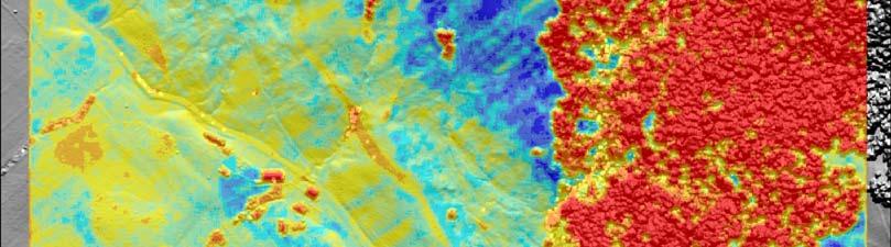
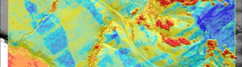
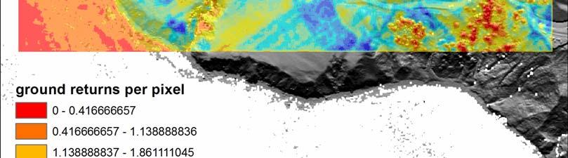
19 Pts per search area (1.5 m^2)
20 Max surface
21 Mean surface
")
22 Inverse Distance Weighted (IDW) surface
23 Minimum surface
24 Implementation Overview: The GLW utilizes advanced spatial databases (IBM DB2), GRASS Open Source GIS, custom DEM generation code, Kepler Workflow manager and web service technology to distribute, interpolate, and analyze LiDAR data. GRASS GIS & Custom binning algorithm
 4. Dragon s Back portion of the SAF (B4) 5.")
25 Current GLW Status Datasets online: 1. Northern San Andreas Fault 2. West Rainier Seismic Zone Source: 3. Eastern California Shear Zone (Mike Oskin PI) 4. Dragon s Back portion of the SAF (B4) 5. Full B4 Dataset (Southern SAF and SJF) Total of ~38 billion LiDAR returns available via GLW
26 Future Functionality: Interactive vegetation filtering and feature extraction (implement open source algorithms) 2 nd order products: Filled and hydrologically corrected DEMs. Derivative products

27 Future Functionality: TLS integration: Seamless integration at 2.5 D New tools and approaches for 3D Nested resolution datasets. Raster imagery integration Web-based Viz: Interface with GEON web-based mapping (2 & 3D) Fledermaus or VRML web services


28 LiDAR/imagery fusion: 4 cm pixel balloon aerial photo merged with 25 cm B4 DEM.
29 Implications GLW likely distribution pathway for forthcoming GeoEarthscope LiDAR datasets Discussions underway with USGS EROS Data Center to expose their LiDAR archive (CLICK), NED and remotely sensed data (Landsat, ASTER, MODIS) via GEON portal integrated access to nested resolution DEMs and imagery. GLW is a proof of concept for utilization of cyberinfrastructure to enhance access to the next generation geoscience datasets and processing tools. Generic and scaleable GEON architecture applicable to numerous (geo) science datasets.

30 Proposed model for accessing and processing distributed topography and imagery data
31 GEON LiDAR Workflow Access Instructions: More information on the GLW: Efrat Jaeger-Frank, Christopher J. Crosby, Ashraf Memon, Viswanath Nandigam, J. Ramon Arrowsmith, Jeffery Conner, Ilkay Altintas, Chaitan Baru, A Three Tier Architecture for LiDAR Interpolation and Analysis, Lecture Notes in Computer Science, Volume 3993, Apr 2006, Pages , DOI: / _123. Crosby, C.J. et al., A geoinformatics-based approach to LiDAR data distribution and processing in preparation. Abstracts, posters & powerpoints + LViz download:
Enhanced Access to High-Resolution LiDAR Topography through Cyberinfrastructure-Based Data Distribution and Processing
 Enhanced Access to High-Resolution LiDAR Topography through Cyberinfrastructure-Based Data Distribution and Processing Christopher J. Crosby, J Ramón Arrowsmith Jeffrey Connor, Gilead Wurman Efrat Jaeger-Frank,
A Three Tier Architecture for LiDAR Interpolation and Analysis
 A Three Tier Architecture for LiDAR Interpolation and Analysis Efrat Jaeger-Frank 1, Christopher J. Crosby 2,AshrafMemon 1, Viswanath Nandigam 1, J. Ramon Arrowsmith 2, Jeffery Conner 2, Ilkay Altintas
GEON LiDAR Workflow (GLW) Users Guide
 Users Guide") GEON LiDAR Workflow (GLW) Users Guide Joshua Coyan Christopher Crosby Ramón Arrowsmith School of Earth and Space Exploration Arizona State University 24 October 2007 http://lidar.asu.edu Table of Contents
GEON LiDAR Workflow (GLW) Users Guide Joshua Coyan Christopher Crosby Ramón Arrowsmith School of Earth and Space Exploration Arizona State University 24 October 2007 http://lidar.asu.edu Table of Contents
EarthCube and Cyberinfrastructure for the Earth Sciences: Lessons and Perspective from OpenTopography
 EarthCube and Cyberinfrastructure for the Earth Sciences: Lessons and Perspective from OpenTopography Christopher Crosby, San Diego Supercomputer Center J Ramon Arrowsmith, Arizona State University Chaitan
A GEOINFORMATICS APPROACH TO LIDAR DATA DISTRIBUTION AND PROCESSING FOR THE EARTH SCIENCES
 A GEOINFORMATICS APPROACH TO LIDAR DATA DISTRIBUTION AND PROCESSING FOR THE EARTH SCIENCES ABSTRACT The emergence of new digital data acquisition technologies in the earth sciences has important implications
GEON Points2Grid Utility Instructions By: Christopher Crosby OpenTopography Facility, San Diego Supercomputer Center
 GEON Points2Grid Utility Instructions By: Christopher Crosby (ccrosby@sdsc.edu) OpenTopography Facility, San Diego Supercomputer Center (Formerly: GEON / Active Tectonics Research Group School of Earth
A three tier architecture applied to LiDAR processing and monitoring
 Scientific Programming 14 (2006) 185 194 185 IOS Press A three tier architecture applied to LiDAR processing and monitoring Efrat Jaeger-Frank a,, Christopher J. Crosby b, Ashraf Memon a, Viswanath Nandigam
Crea%ng DEMs From LiDAR Point Cloud Data
 Crea%ng DEMs From LiDAR Point Cloud Data C. Crosby (ccrosby@sdsc.edu) San Diego Supercomputer Center / OpenTopography.org Ramon Arrowsmith SESE, ASU 2009 SCEC LiDAR Short Course Digital ElevaEon Models
GeoEarthScope NoCAL San Andreas System LiDAR pre computed DEM tutorial
 GeoEarthScope NoCAL San Andreas System LiDAR pre computed DEM tutorial J Ramón Arrowsmith Chris Crosby School of Earth and Space Exploration Arizona State University ramon.arrowsmith@asu.edu http://lidar.asu.edu
Crea%ng DEMs From LiDAR Point Cloud Data
 Crea%ng DEMs From LiDAR Point Cloud Data C. Crosby (ccrosby@sdsc.edu) San Diego Supercomputer Center / OpenTopography.org Ramon Arrowsmith SESE, ASU 2011 SCEC LiDAR Short Course Digital ElevaEon Models
The LViz Users Guide
 The LViz Users Guide Joshua Coyan Christopher Crosby Ramón Arrowsmith Jeff Conner* School of Earth and Space Exploration Arizona State University 24 October 2007 http://lidar.asu.edu Table of Contents
Scientific Workflow Tools. Daniel Crawl and Ilkay Altintas San Diego Supercomputer Center UC San Diego
 Scientific Workflow Tools Daniel Crawl and Ilkay Altintas San Diego Supercomputer Center UC San Diego 1 escience Today Increasing number of Cyberinfrastructure (CI) technologies Data Repositories: Network
Lecture 23 - LiDAR. GEOL 452/552 - GIS for Geoscientists I. Scanning Lidar. 30 m DEM. Lidar representations:
 GEOL 452/552 - GIS for Geoscientists I Lecture 23 - LiDAR LiDAR - some background (thanks to Chris Kahle, DNR) Converting Lidar point data to a raster Look at online lidar data for Iowa (1m hillshaded)
Documentation for the analysis of the ground-based Alvord Basin LiDAR dataset
 Documentation for the analysis of the ground-based Alvord Basin LiDAR dataset Introduction David E. Haddad david.e.haddad@asu.edu July 2008 This report presents the procedures carried out, the results
Point clouds and DEMs
 Point clouds and DEMs J Ramón Arrowsmith School of Earth and Space Exploration Arizona State University Christopher J. Crosby UNAVCO Tutorial notes (April 2016) Point clouds and DEMs 1. Download tahoe.las
Introduction to Lidar Technology and Data Collection
 Introduction to Lidar Technology and Data Collection Christopher Crosby San Diego Supercomputer Center / OpenTopography (with content adapted from NCALM, David Phillips (UNVACO), Ian Madin (DOGAMI), Ralph
Outline of Presentation. Introduction to Overwatch Geospatial Software Feature Analyst and LIDAR Analyst Software
 Outline of Presentation Automated Feature Extraction from Terrestrial and Airborne LIDAR Presented By: Stuart Blundell Overwatch Geospatial - VLS Ops Co-Author: David W. Opitz Overwatch Geospatial - VLS
DEM Artifacts: Layering or pancake effects
 Outcomes DEM Artifacts: Stream networks & watersheds derived using ArcGIS s HYDROLOGY routines are only as good as the DEMs used. - Both DEM examples below have problems - Lidar and SRTM DEM products are
Digital Elevation Models
 Digital Elevation Models National Elevation Dataset 1 Data Sets US DEM series 7.5, 30, 1 o for conterminous US 7.5, 15 for Alaska US National Elevation Data (NED) GTOPO30 Global Land One-kilometer Base
Aerial and Mobile LiDAR Data Fusion
 Creating Value Delivering Solutions Aerial and Mobile LiDAR Data Fusion Dr. Srini Dharmapuri, CP, PMP What You Will Learn About LiDAR Fusion Mobile and Aerial LiDAR Technology Components & Parameters Project
Tutorial 1: Downloading elevation data
 Tutorial 1: Downloading elevation data Objectives In this exercise you will learn how to acquire elevation data from the website OpenTopography.org, project the dataset into a UTM coordinate system, and
ArcGIS for Server Imagery Update. Cody A. Benkelman Technical Product Manager, Imagery
 ArcGIS for Server Imagery Update Cody A. Benkelman Technical Product Manager, Imagery Outline Mosaic dataset Management and dissemination of imagery - Dynamic image services, Tiled Cache Visualization
Algorithms for GIS: Terrain simplification
 Algorithms for GIS: Terrain simplification Digital terrain models in GIS grid (raster) TIN Data Sources: digitizing contour maps Data Sources: satellite imagery Data Sources: satellite imagery \ Data Sources:
Lidar Working with LAS Datasets
 2013 Esri International User Conference July 8 12, 2013 San Diego, California Technical Workshop Lidar Working with LAS Datasets Raghav Vemula (3D Team) Esri UC2013. Technical Workshop. Agenda Las Dataset
Supplementary material to LaDiCaoz and LiDARimager MATLAB GUIs for LiDAR data handling and lateral displacement measurement
 Supplementary material to LaDiCaoz and LiDARimager MATLAB GUIs for LiDAR data handling and lateral displacement measurement Olaf Zielke 1 *, J Ramon Arrowsmith 1 1 School of Earth and Space Exploration,
ENVI ANALYTICS ANSWERS YOU CAN TRUST
 ENVI ANALYTICS ANSWERS YOU CAN TRUST HarrisGeospatial.com Since its launch in 1991, ENVI has enabled users to leverage remotely sensed data to better understand our complex world. Over the years, Harris
APPENDIX E2. Vernal Pool Watershed Mapping
 APPENDIX E2 Vernal Pool Watershed Mapping MEMORANDUM To: U.S. Fish and Wildlife Service From: Tyler Friesen, Dudek Subject: SSHCP Vernal Pool Watershed Analysis Using LIDAR Data Date: February 6, 2014
GEOGRAPHIC INFORMATION SYSTEMS Lecture 24: Spatial Analyst Continued
 GEOGRAPHIC INFORMATION SYSTEMS Lecture 24: Spatial Analyst Continued Spatial Analyst - Spatial Analyst is an ArcGIS extension designed to work with raster data - in lecture I went through a series of demonstrations
An Introduction to Lidar & Forestry May 2013
 An Introduction to Lidar & Forestry May 2013 Introduction to Lidar & Forestry Lidar technology Derivatives from point clouds Applied to forestry Publish & Share Futures Lidar Light Detection And Ranging
Lidar and GIS: Applications and Examples. Dan Hedges Clayton Crawford
 Lidar and GIS: Applications and Examples Dan Hedges Clayton Crawford Outline Data structures, tools, and workflows Assessing lidar point coverage and sample density Creating raster DEMs and DSMs Data area
NEXTMap World 30 Digital Surface Model
 NEXTMap World 30 Digital Surface Model Intermap Technologies, Inc. 8310 South Valley Highway, Suite 400 Englewood, CO 80112 083013v3 NEXTMap World 30 (top) provides an improvement in vertical accuracy
2. POINT CLOUD DATA PROCESSING
 Point Cloud Generation from suas-mounted iphone Imagery: Performance Analysis A. D. Ladai, J. Miller Towill, Inc., 2300 Clayton Road, Suite 1200, Concord, CA 94520-2176, USA - (andras.ladai, jeffrey.miller)@towill.com
ENVI THE PREMIER SOFTWARE FOR EXTRACTING INFORMATION FROM GEOSPATIAL DATA
 ENVI THE PREMIER SOFTWARE FOR EXTRACTING INFORMATION FROM GEOSPATIAL DATA HarrisGeospatial.com BENEFITS Use one solution to work with all your data types Access a complete suite of analysis tools Customize
Edwin Nissen (Colorado School of Mines)
") Aligning point clouds and topographic change detection Edwin Nissen (Colorado School of Mines) Oskin et al. (2012), Science Thanks to: Ramon Arrowsmith, Srikanth Saripalli, Aravindhan Krishnan (ASU), Adrian
Aligning point clouds and topographic change detection Edwin Nissen (Colorado School of Mines) Oskin et al. (2012), Science Thanks to: Ramon Arrowsmith, Srikanth Saripalli, Aravindhan Krishnan (ASU), Adrian
Exercise 1: Introduction to LiDAR Point Cloud Data using the Fusion Software Package
 Exercise 1: Introduction to LiDAR Point Cloud Data using the Fusion Software Package Christopher Crosby, San Diego Supercomputer Center / OpenTopography (Adapted from tutorial by Ian Madin, DOGAMI) Last
Image Services for Elevation Data
 Image Services for Elevation Data Peter Becker Need for Elevation Using Image Services for Elevation Data sources Creating Elevation Service Requirement: GIS and Imagery, Integrated and Accessible Field
Imagery and Raster Data in ArcGIS. Abhilash and Abhijit
 Imagery and Raster Data in ArcGIS Abhilash and Abhijit Agenda Imagery in ArcGIS Mosaic datasets Raster processing ArcGIS is a Comprehensive Imagery System Integrating All Types, Sources, and Sensor Models
NEXTMap World 10 Digital Elevation Model
 NEXTMap Digital Elevation Model Intermap Technologies, Inc. 8310 South Valley Highway, Suite 400 Englewood, CO 80112 10012015 NEXTMap (top) provides an improvement in vertical accuracy and brings out greater
Notes on Lidar interpolation
 Notes on Lidar interpolation J Ramón Arrowsmith with contributions from Chris Crosby and Jeff Conner Department of Geological Sciences Arizona State University Tempe, AZ, 85287 ramon.arrowsmith@asu.edu
Esri International User Conference. July San Diego Convention Center. Lidar Solutions. Clayton Crawford
 Esri International User Conference July 23 27 San Diego Convention Center Lidar Solutions Clayton Crawford Outline Data structures, tools, and workflows Assessing lidar point coverage and sample density
N.J.P.L.S. An Introduction to LiDAR Concepts and Applications
 N.J.P.L.S. An Introduction to LiDAR Concepts and Applications Presentation Outline LIDAR Data Capture Advantages of Lidar Technology Basics Intensity and Multiple Returns Lidar Accuracy Airborne Laser
Final project: Lecture 21 - Chapter 8 (Raster Analysis, part2) GEOL 452/552 - GIS for Geoscientists I
 GEOL 452/552 - GIS for Geoscientists I") GEOL 452/552 - GIS for Geoscientists I Lecture 21 - Chapter 8 (Raster Analysis, part2) Talk about class project (copy follow_along_data\ch8a_class_ex into U:\ArcGIS\ if needed) Catch up with lecture 20
GEOL 452/552 - GIS for Geoscientists I Lecture 21 - Chapter 8 (Raster Analysis, part2) Talk about class project (copy follow_along_data\ch8a_class_ex into U:\ArcGIS\ if needed) Catch up with lecture 20
VALIDATION OF A NEW 30 METER GROUND SAMPLED GLOBAL DEM USING ICESAT LIDARA ELEVATION REFERENCE DATA
 VALIDATION OF A NEW 30 METER GROUND SAMPLED GLOBAL DEM USING ICESAT LIDARA ELEVATION REFERENCE DATA M. Lorraine Tighe Director, Geospatial Solutions Intermap Session: Photogrammetry & Image Processing
MODULE 1 BASIC LIDAR TECHNIQUES
 MODULE SCENARIO One of the first tasks a geographic information systems (GIS) department using lidar data should perform is to check the quality of the data delivered by the data provider. The department
Managing Lidar and Photogrammetric Point Clouds. Lindsay Weitz Cody Benkelman
 and Photogrammetric Point Clouds Lindsay Weitz Cody Benkelman Presentation Context What is lidar, and how does it work? Not this presentation! What can you do with lidar in ArcGIS? What does Esri recommend
DEM Artifacts: Layering or pancake effects
 Outcomes DEM Artifacts: Stream networks & watersheds derived using ArcGIS s HYDROLOGY routines are only as good as the DEMs used. - Both DEM examples below have problems - Lidar and SRTM DEM products are
Contents of Lecture. Surface (Terrain) Data Models. Terrain Surface Representation. Sampling in Surface Model DEM
 Data Models. Terrain Surface Representation. Sampling in Surface Model DEM") Lecture 13: Advanced Data Models: Terrain mapping and Analysis Contents of Lecture Surface Data Models DEM GRID Model TIN Model Visibility Analysis Geography 373 Spring, 2006 Changjoo Kim 11/29/2006 1
Lecture 13: Advanced Data Models: Terrain mapping and Analysis Contents of Lecture Surface Data Models DEM GRID Model TIN Model Visibility Analysis Geography 373 Spring, 2006 Changjoo Kim 11/29/2006 1
Lecture 4: Digital Elevation Models
 Lecture 4: Digital Elevation Models GEOG413/613 Dr. Anthony Jjumba 1 Digital Terrain Modeling Terms: DEM, DTM, DTEM, DSM, DHM not synonyms. The concepts they illustrate are different Digital Terrain Modeling
2010 LiDAR Project. GIS User Group Meeting June 30, 2010
 2010 LiDAR Project GIS User Group Meeting June 30, 2010 LiDAR = Light Detection and Ranging Technology that utilizes lasers to determine the distance to an object or surface Measures the time delay between
Global Multi-Resolution Topography (GMRT) Synthesis. LDEO-NSF supported
 Synthesis. LDEO-NSF supported") Global Multi-Resolution Topography (GMRT) Synthesis LDEO-NSF supported Suzanne Carbotte, Vicki Ferrini, Justin Coplan, William Ryan, Suzanne O Hara, Kevin Mclain, Frank Nitsche, John Morton, Rose Anne
Global Multi-Resolution Topography (GMRT) Synthesis LDEO-NSF supported Suzanne Carbotte, Vicki Ferrini, Justin Coplan, William Ryan, Suzanne O Hara, Kevin Mclain, Frank Nitsche, John Morton, Rose Anne
Existing Elevation Data Sets. Quality Level 2 (QL2) Lidar Data Sets. Better Land Characterization More Accurate Results!
 Lidar Data Sets. Better Land Characterization More Accurate Results!") Existing Elevation Data Sets Out of Date: Most > 40 yrs old Data range from 15 yrs old to > 70 yrs old Spatial Resolution: 33 ft (10 m) or coarser Vertical Accuracy: 3.3 ft 6.6 ft (1 2 m) or worse Quality
Existing Elevation Data Sets Out of Date: Most > 40 yrs old Data range from 15 yrs old to > 70 yrs old Spatial Resolution: 33 ft (10 m) or coarser Vertical Accuracy: 3.3 ft 6.6 ft (1 2 m) or worse Quality
TLS Parameters, Workflows and Field Methods
 TLS Parameters, Workflows and Field Methods Marianne Okal, UNAVCO GSA, September 23 rd, 2016 How a Lidar instrument works (Recap) Transmits laser signals and measures the reflected light to create 3D point
Surface Analysis with 3D Analyst
 2013 Esri International User Conference July 8 12, 2013 San Diego, California Technical Workshop Surface Analysis with 3D Analyst Khalid H. Duri Esri UC2013. Technical Workshop. Why use 3D GIS? Because
Lecture 22 - Chapter 8 (Raster Analysis, part 3)
") GEOL 452/552 - GIS for Geoscientists I Lecture 22 - Chapter 8 (Raster Analysis, part 3) Today: Zonal Analysis (statistics) for polygons, lines, points, interpolation (IDW), Effects Toolbar, analysis masks
GEOL 452/552 - GIS for Geoscientists I Lecture 22 - Chapter 8 (Raster Analysis, part 3) Today: Zonal Analysis (statistics) for polygons, lines, points, interpolation (IDW), Effects Toolbar, analysis masks
Lecture 21 - Chapter 8 (Raster Analysis, part2)
") GEOL 452/552 - GIS for Geoscientists I Lecture 21 - Chapter 8 (Raster Analysis, part2) Today: Digital Elevation Models (DEMs), Topographic functions (surface analysis): slope, aspect hillshade, viewshed,
GEOL 452/552 - GIS for Geoscientists I Lecture 21 - Chapter 8 (Raster Analysis, part2) Today: Digital Elevation Models (DEMs), Topographic functions (surface analysis): slope, aspect hillshade, viewshed,
Using Imagery for Intelligence Analysis
 2013 Esri International User Conference July 8 12, 2013 San Diego, California Technical Workshop Using Imagery for Intelligence Analysis Renee Bernstein Natalie Campos Esri UC2013. Technical Workshop.
GIS-Generated Street Tree Inventory Pilot Study
 GIS-Generated Street Tree Inventory Pilot Study Prepared for: MSGIC Meeting Prepared by: Beth Schrayshuen, PE Marla Johnson, GISP 21 July 2017 Agenda 2 Purpose of Street Tree Inventory Pilot Study Evaluation
What s New in Imagery in ArcGIS. Presented by: Christopher Patterson Date: October 18, 2017
 What s New in Imagery in ArcGIS Presented by: Christopher Patterson Date: October 18, 2017 Imagery in ArcGIS Advancing 2010 Stretch, Extract Bands Clip, Mask Reproject, Orthorectify, Pan Sharpen Vegetation
Overview. 1. Aerial LiDAR in Wisconsin (20 minutes) 2. Demonstration of data in CAD (30 minutes) 3. High Density LiDAR (20 minutes)
 2. Demonstration of data in CAD (30 minutes) 3. High Density LiDAR (20 minutes)") Overview 1. Aerial LiDAR in Wisconsin (20 minutes) 2. Demonstration of data in CAD (30 minutes) 3. High Density LiDAR (20 minutes) 4. Aerial lidar technology advancements (15 minutes) 5. Q & A 1. Aerial
Overview 1. Aerial LiDAR in Wisconsin (20 minutes) 2. Demonstration of data in CAD (30 minutes) 3. High Density LiDAR (20 minutes) 4. Aerial lidar technology advancements (15 minutes) 5. Q & A 1. Aerial
UTILIZACIÓN DE DATOS LIDAR Y SU INTEGRACIÓN CON SISTEMAS DE INFORMACIÓN GEOGRÁFICA
 UTILIZACIÓN DE DATOS LIDAR Y SU INTEGRACIÓN CON SISTEMAS DE INFORMACIÓN GEOGRÁFICA Aurelio Castro Cesar Piovanetti Geographic Mapping Technologies Corp. (GMT) Consultores en GIS info@gmtgis.com Geographic
From Multi-sensor Data to 3D Reconstruction of Earth Surface: Innovative, Powerful Methods for Geoscience and Other Applications
 From Multi-sensor Data to 3D Reconstruction of Earth Surface: Innovative, Powerful Methods for Geoscience and Other Applications Bea Csatho, Toni Schenk*, Taehun Yoon* and Michael Sheridan, Department
Initial GMES Service for Geospatial Reference Data Access. Remote Sensing Department. INDRA ESPACIO
 Initial GMES Service for Geospatial Reference Data Access Remote Sensing Department. INDRA ESPACIO Brussels, 260-09-2011 CONTENT 01 Overview 02 EU-DEM 03 Hydrography 04 Production Coordination 05 Access
Big data for big river science: data intensive tools, techniques, and projects at the USGS/Columbia Environmental Research Center
 Big data for big river science: data intensive tools, techniques, and projects at the USGS/Columbia Environmental Research Center Ed Bulliner U.S. Geological Survey, Columbia Environmental Research Center
What s New in ecognition 9.0
 What s New in ecognition 9.0 Dr. Waldemar Krebs tranforming data into GIS ready information Trends in Earth Observation Increasing need for detailed, up-to-date information as a basis for planning and
Drone2Map for ArcGIS: Bring Drone Imagery into ArcGIS. Will
 Drone2Map for ArcGIS: Bring Drone Imagery into ArcGIS Will Meyers @MeyersMaps A New Window on the World Personal Mapping for Micro-Geographies Accurate High Quality Simple Low-Cost Drone2Map for ArcGIS
DIT Computing Research Seminar Dr. Bianca Schoen-Phelan. The Evolution of LiDAR for 3D Data Storage, Indexing and Querying
 DIT Computing Research Seminar Dr. Bianca Schoen-Phelan The Evolution of LiDAR for 3D Data Storage, Indexing and Querying LiDAR Storage, Indexing and Querying Dr. Bianca Schoen-Phelan March 2014 ToC 1
Situations and Ontologies: helping geoscientists understand and share the semantics surrounding their computational resources
 Situations and Ontologies: helping geoscientists understand and share the semantics surrounding their computational resources Mark Gahegan GeoVISTA Center, Department of Geography, The Pennsylvania State
Accuracy Assessment of Ames Stereo Pipeline Derived DEMs Using a Weighted Spatial Dependence Model
 Accuracy Assessment of Ames Stereo Pipeline Derived DEMs Using a Weighted Spatial Dependence Model Intro Problem Statement A successful lunar mission requires accurate, high resolution data products to
A Method to Create a Single Photon LiDAR based Hydro-flattened DEM
 A Method to Create a Single Photon LiDAR based Hydro-flattened DEM Sagar Deshpande 1 and Alper Yilmaz 2 1 Surveying Engineering, Ferris State University 2 Department of Civil, Environmental, and Geodetic
TOCOMEE: A topological, coloured model of the Earth's elevation
 TOCOMEE: A topological, coloured model of the Earth's elevation Dr. Michael Nolde German Aerospace Center (DLR) mno@flatpolar.org Abstract The presented dataset provides free global, topological, coloured
Workshops funded by the Minnesota Environment and Natural Resources Trust Fund
 Workshops funded by the Minnesota Environment and Natural Resources Trust Fund Conservation Applications of LiDAR Data Workshops funded by: Minnesota Environment and Natural Resources Trust Fund Presented
LiDAR Applications. Examples of LiDAR applications. forestry hydrology geology urban applications
 LiDAR Applications Examples of LiDAR applications forestry hydrology geology urban applications 1 Forestry applications canopy heights individual tree and crown mapping estimated DBH and leaf area index
WInSAR Operations Report
 WInSAR Operations Report Christopher Crosby & Scott Baker (with considerable contributions from Fran Boler, Susanna Gross, Cassidy Jay) AGU WInSAR Business Meeting, December 5, 2012 Contact: winsar@unavco.org
GIS data input. In the early days of GIS 1980s and early 1990s. We used canned datasets for teaching (from USA)
") GIS data input GIS is the automated : acquisition - input management analysis display of spatial data In the early days of GIS 1980s and early 1990s There were no or little GIS data We used canned datasets
GIS data input GIS is the automated : acquisition - input management analysis display of spatial data In the early days of GIS 1980s and early 1990s There were no or little GIS data We used canned datasets
v Working with Rasters SMS 12.1 Tutorial Requirements Raster Module Map Module Mesh Module Time minutes Prerequisites Overview Tutorial
 v. 12.1 SMS 12.1 Tutorial Objectives This tutorial teaches how to import a Raster, view elevations at individual points, change display options for multiple views of the data, show the 2D profile plots,
UAV Flight Operations for Mapping. Precision. Accuracy. Reliability
 UAV Flight Operations for Mapping Precision. Accuracy. Reliability Part One: Why is Mapping different? Part Two: What about accuracy and precision? Part Three: What is the Workflow? Part Four: AGENDA What
MassCEC Rooftop Solar Map
 MassCEC Rooftop Solar Map Data and Methods Summary Critigen, LLC Overview The detailed analysis of solar rooftop potential is a multi-step workflow with many facets and input parameters to the analysis
Local Elevation Surface Modeling using GPS Derived Point Clouds. John G. Whitman, Jr.
 Local Elevation Surface Modeling using GPS Derived Point Clouds WhitmanJ2@myfairpoint.net Study Area Overview Topographic Background NAIP with Roads and Streams Public DEM Models of Study Area National
I. An Intro to ArcMap Version 9.3 and 10. 1) Arc Map is basically a build your own Google map
 Arc Map is basically a build your own Google map") I. An Intro to ArcMap Version 9.3 and 10 What is Arc Map? 1) Arc Map is basically a build your own Google map a. Display and manage geo-spatial data (maps, images, points that have a geographic location)
I. An Intro to ArcMap Version 9.3 and 10 What is Arc Map? 1) Arc Map is basically a build your own Google map a. Display and manage geo-spatial data (maps, images, points that have a geographic location)
Creating Surfaces. Steve Kopp Steve Lynch
 Steve Kopp Steve Lynch Overview Learn the types of surfaces and the data structures used to store them Emphasis on surface interpolation Learn the interpolation workflow Understand how interpolators work
New Mexico s RGIS Program: State Geospatial Data Clearinghouse
 New Mexico s RGIS Program: State Geospatial Data Clearinghouse Laura Gleasner Su Zhang November 10, 2016 New Mexico RGIS: The State Digital Geospatial Data Clearinghouse The Resource Geographic Information
Lecture 20 - Chapter 8 (Raster Analysis, part1)
") GEOL 452/552 - GIS for Geoscientists I Lecture 20 - Chapter 8 (Raster Analysis, part) 4 lectures on rasters - but won t cover everything (Raster GIS course: Geol 588: GIS II (Spring 20) Today: Raster data,
GEOL 452/552 - GIS for Geoscientists I Lecture 20 - Chapter 8 (Raster Analysis, part) 4 lectures on rasters - but won t cover everything (Raster GIS course: Geol 588: GIS II (Spring 20) Today: Raster data,
Automated Feature Extraction from Aerial Imagery for Forestry Projects
 Automated Feature Extraction from Aerial Imagery for Forestry Projects Esri UC 2015 UC706 Tuesday July 21 Bart Matthews - Photogrammetrist US Forest Service Southwestern Region Brad Weigle Sr. Program
Tools, Tips, and Workflows Exporting Final Product LP360
 LP360 Support Revision 1.0 l Final products can be exported from LIDAR data using either LP360 command line executables or the LP360 Export Wizard. Some export functions and resulting products include,
The Feature Analyst Extension for ERDAS IMAGINE
 The Feature Analyst Extension for ERDAS IMAGINE Automated Feature Extraction Software for GIS Database Maintenance We put the information in GIS SM A Visual Learning Systems, Inc. White Paper September
TLS Parameters, Workflows and Field Methods
 TLS Parameters, Workflows and Field Methods Marianne Okal, UNAVCO GSA, October 20 th, 2017 How a Lidar instrument works (Recap) Transmits laser signals and measures the reflected light to create 3D point
Managing Imagery and Raster Data using Mosaic Datasets
 Esri European User Conference October 15-17, 2012 Oslo, Norway Hosted by Esri Official Distributor Managing Imagery and Raster Data using Mosaic Datasets Peter Becker ArcGIS is a Comprehensive Imagery
How to Access Remote Sensing Data Using EarthExplorer
 How to Access Remote Sensing Data Using EarthExplorer https://earthexplorer.usgs.gov/ EarthExplorer is the most-used tool to access remote sensing data at the (USGS) Earth Resources Observation and Science
Remote Sensing in an
 Chapter 2: Adding Data to a Map Document Remote Sensing in an ArcMap Environment Remote Sensing Analysis in an ArcMap Environment Tammy E. Parece Image source: landsat.usgs.gov Tammy Parece James Campbell
Georgia Coastal Ecosystems LTER Information Management
 Georgia Coastal Ecosystems LTER Information Management Wade Sheldon, Information Manager Adam Sapp, Assistant Information Manager University of Georgia Athens, Georgia GCE IM Overview Information Management
LORI COLLINS, RESEARCH ASSOCIATE PROFESSOR CONTRIBUTIONS BY: RICHARD MCKENZIE AND GARRETT SPEED, DHHC USF L IBRARIES
 LORI COLLINS, RESEARCH ASSOCIATE PROFESSOR CONTRIBUTIONS BY: RICHARD MCKENZIE AND GARRETT SPEED, DHHC USF L IBRARIES AERIAL AND TERRESTRIAL SURVEY WORKFLOWS Workflow from project planning applications
Using LiDAR (Light Distancing And Ranging) data to more accurately describe avalanche terrain
 data to more accurately describe avalanche terrain") International Snow Science Workshop, Davos 009, Proceedings Using LiDAR (Light Distancing And Ranging) data to more accurately describe avalanche terrain Christopher M. McCollister, and Robert H. Comey,
International Snow Science Workshop, Davos 009, Proceedings Using LiDAR (Light Distancing And Ranging) data to more accurately describe avalanche terrain Christopher M. McCollister, and Robert H. Comey,
TLS Parameters, Workflows and Field Methods
 TLS Parameters, Workflows and Field Methods Marianne Okal, UNAVCO June 20 th, 2014 How a Lidar instrument works (Recap) Transmits laser signals and measures the reflected light to create 3D point clouds.
ENVI 5 & E3De. The Next Generation of Image Analysis
 ENVI 5 & E3De The Next Generation of Image Analysis The information contained in this document pertains to software products and services that are subject to the controls of the Export Administration Regulations
A SENSOR FUSION APPROACH TO COASTAL MAPPING
 A SENSOR FUSION APPROACH TO COASTAL MAPPING Maryellen Sault, NOAA, National Ocean Service, National Geodetic Survey Christopher Parrish, NOAA, National Ocean Service, National Geodetic Survey Stephen White,
Accelerating the Scientific Exploration Process with Kepler Scientific Workflow System
 Accelerating the Scientific Exploration Process with Kepler Scientific Workflow System Jianwu Wang, Ilkay Altintas Scientific Workflow Automation Technologies Lab SDSC, UCSD project.org UCGrid Summit,
LiDAR Derived Contours
 LiDAR Derived Contours Final Delivery June 10, 2009 Prepared for: Prepared by: Metro 600 NE Grand Avenue Portland, OR 97232 Watershed Sciences, Inc. 529 SW Third Avenue, Suite 300 Portland, OR 97204 Metro
Automating Distributed Raster Analysis using the Image Server REST API. Jie Zhang Zikang Zhou Demo Theater 2 - Oasis 1
 Automating Distributed Raster Analysis using the Image Server REST API Jie Zhang Zikang Zhou Demo Theater 2 - Oasis 1 What is Distributed Raster Analysis? From 10.5, ArcGIS has a new way to create and
STRATEGIES FOR ALTERNATE APPROACHES FOR VEGETATION INDICES COMPOSITING USING PARALLEL TEMPORAL MAP ALGEBRA
 STRATEGIES FOR ALTERNATE APPROACHES FOR VEGETATION INDICES COMPOSITING USING PARALLEL TEMPORAL MAP ALGEBRA Bijay Shrestha, Dr. Charles O Hara Dr. Nicholas H. Younan Mississippi State University OUTLINE
Python: Working with Multidimensional Scientific Data. Nawajish Noman Deng Ding
 Python: Working with Multidimensional Scientific Data Nawajish Noman Deng Ding Outline Scientific Multidimensional Data Ingest and Data Management Analysis and Visualization Extending Analytical Capabilities