Civil Air Patrol. Forensics in Search and Rescue. 03 June 2017 CITIZENS SERVING COMMUNITIES
|
|
|
- Charleen Morgan
- 6 years ago
- Views:
Transcription
1 Civil Air Patrol Forensics in Search and Rescue 03 June 2017 CITIZENS SERVING COMMUNITIES

2 Topics AFRCC/CAP Cellular/Radar Forensics Understanding the raw data and analyzed data Tips on what to do during a search
3 Courtesy of Chris Hecht, Arizona DPS 3

4 Courtesy of Chris Hecht, Arizona DPS 4


5 Air Force Rescue Coordination Center & Civil Air Patrol Cellular Forensics CAP has been carrying out the cellular forensics missions for AFRCC since 2006 AFRCC/CAP provides cell forensics support on CONUS search and rescue missions similar to how they offer CAP air/ground teams and other military resources It started as a last resort tool for locating missing person and overdue aircraft, but is now a primary resource Some agencies are requesting cell forensics exclusively (no other federal assets requested)

6 Non Disclosure Letter 20-Jun-17 CITIZENS SERVING COMMUNITIES 6

7 Cell phone analysis & other clues: ELTs, Radar, LKP, etc Cell phones can provide real time and historical data Phones are small and often survive harsh situations Phones are prevalent and highly likely to be on a missing aircraft or missing person


8

9
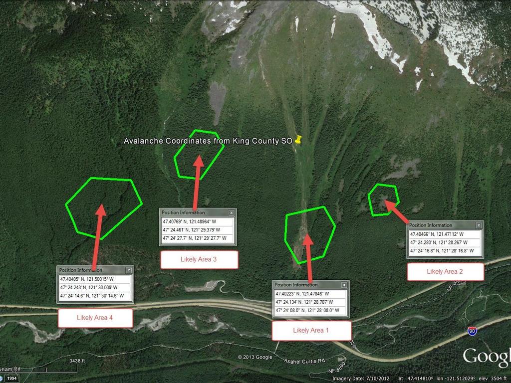
10 Likely Areas Likely Areas are the result of analysis by a cellular forensics expert and represents the location(s) the phone may have been during a certain time frame Result of reviewing cell tower locations, sector information, coverage maps, distance data, and more Takes into account tolerances of supporting data Typically shown as a green outlined area - bounding the area in which the phone was most likely to be located during the given time stamp Likely Areas correspond to a time frame Gives the IC or Planning Section at a glance view of where a phone was located at a given time
11 11
12 Propagation Analysis and Coverage Maps Propagation Analysis uses computer models of terrain, tower height, antenna again, transmitter power levels, and more to determine places on the ground that can communicate with a tower The result of Propagation Analysis is a Coverage Map Typical Coverage Maps show places that you can stand on the ground and communicate with a given cell phone tower Coverage Maps show places that also lack coverage, which may also be helpful

13 Coverage Map

14
15 Available Raw Data Data is either real time or historical Real time data can be provided when a phone is powered on and with the coverage area Historical data is records of transactions with the phone that occurred sometime in the past, while the phone was on and in the network coverage area Each cell phone provider has different capabilities, which results in data that must be interpreted in different ways
16 When is historical data recorded? Any interaction with the phone such as calls, text messages, or internet usage GPS information is not recorded The exception is calls to 911 which often have highly accurate coordinates, often derived from assisted GPS
17 Raw Data: Network Based Locations May be available in real time or as historical data Accuracy of each transaction is paramount to understanding it s importance to the search If someone can t give you the accuracy data - proceed with caution! These locations are tempting to use because they plot so easily in Google Earth
18 Network Based Locations

19 Find Location

20 Raw Data: Sector Information Sectors utilize directional antennas to maximize coverage in a given direction from a tower 3 sectors per tower are common, but can vary from 1 to more than 6 Sectors provide a way to help understand what side of a tower a phone was for a given transaction

21 1 All Sectors 3Shown 2


22 Raw Data: Distance Information Sometime carriers can report the distance a phone was from a tower during a transaction This distance is derived from timing information (not signal strength) Distance in miles Multiple distance rings from multiple cell sites can allow for very good historical locations ± Distance Accuracy 22
23 Combining pieces of data results in Likely Areas Combining distance, sector, coverage and other clues are often helpful in a search Example the follows is from a search for a missing family who were overdue from a hunting trip Family members reported they were unsure where the missing family was going hunting - expressed interest in places spanning 150 miles Cell phone data (coverage, sector, distance) and knowledge of the areas they expressed interest in, lead to the find

24 Last tower used

25 Coverage map for last tower used
26 not accessed Last sector used not accessed Accessed
27 Distance information for last transaction

28 Likely Areas Defined
29 All the clues together leading to the find


30 The rescue!
31 Things to do during a search Generate data Get the victim to dial 911 Place a call and send a text message to the victim s phone (log it!) - note the number of rings until the phone picks up Understand what the accuracy of information is when handling raw data Request AFRCC/CAP support
32 Tools and Skills Needed To get the most out of interacting with AFRCC/CAP Forensics teams Internet connection at Incident Command Post Google Earth expertise Google Hangouts (not required, but helpful) Go To Meeting Slack
33 New CAP Cellular Forensics Tools CAP s new tools to assist in missions: Determine objective s phone vendor Can determine if the phone is on or off/out of service area Will monitor and alert if the phone is turned back on or travels into a service area Send and receive messages to the objective s phone as needed Automated Google Earth data plotting tools Enhanced coverage plotting capabilities
34 Cellular Forensics Team Contacts Justin Ogden, Maj, CAP Brian Ready, Col, CAP Jerad Hoff, Maj, CAP Paul Combellick 34

35 Civil Air Patrol Citizens Serving Communities!
CITIZENS SERVING COMMUNITIES
 Civil Air Patrol Cellular Forensics Training for Incident Staff Members Brian Ready, Col CAP Justin Ogden, Maj CAP 3-Nov-15 CITIZENS SERVING COMMUNITIES 1 Webinar Presenters John Desmarais Director of
Call Detail Records The Evidence 10/19/2017. Locating Cell Phones
 Cell Phone Location Evidence for Legal Professionals Larry Daniel DFCP, EnCE, ACE, AME, BCE, CTNS, CTA, CWA Locating Cell Phones Least Precise to Most Call Detail Records (Drive Testing) Google Location
Simulator and Search Planner for the USCG SAROPS Search And Rescue Optimal Planning System
 Simulator and Search Planner for the USCG SAROPS Search And Rescue Optimal Planning System Metron Inc 1818 Library Street Reston VA 20190 703 787 8700 SAROPS Background w Developed by Metron, Applied Sciences
Mobile Devices. Objectives. Types of Devices 4/25/2012
 Mobile Devices Objectives Identify mobile devices Learn how mobile devices obtain and transmit information Identify potential evidence that may be obtained from mobile devices Learn where data is stored
Mobile Devices. Questions. NCJRL ICAC Webinar Mobile Devices October 25, Don Mason Associate Director, NCJRL. Presenter
 Mobile Devices Presenter Don Mason Associate Director, NCJRL 662-915-6898 drmason@olemiss.edu Questions Feel free to email any time to: drmason@olemiss.edu Please include your phone number In case it might
A User s Introduction to. Global Rescue s GRID SM Mobile Application. trust
 A User s Introduction to Global Rescue s GRID SM Mobile Application Background As threats to global travelers increase in countries throughout the world, Global Rescue s GRID SM mobile app places critical
Presentation Content
 SMS Fleet (Pty) Ltd Privately owned company established in 2006 Our product My Tracer is a locally developed, brilliant, fully internet based GPS Vehicle tracking system integrated with an innovative automated
WELCOME Mobile Applications Testing. Copyright
 WELCOME Mobile Applications Testing 1 Mobile Applications Testing List of MUST HAVE to survive this class Required Google Drive account Google email Flash Drive Mobile Phone (iphone/android) Desired Have
CITIZENS SERVING COMMUNITIES
 Civil Air Patrol Geospatial Information Interoperability Exploitation Portable (GIIEP) Operator Version 2 Update Training Lt Col Bob Becker, CAP GIIEP Program Coordinator 15-Nov-15 CITIZENS SERVING COMMUNITIES
1/8/2013. Not one, single technology, rather a convergence of several technologies Systems for:
 Tracking Technologies Priscilla ill Grantham, Esq. Sr. Research Counsel National Center for Justice and the Rule of Law Copyright 2012 Priscilla Grantham & National Center for Justice and the Rule of Law
Deployable Communication Systems and IoT for Public Safety. Professor Kamesh Namuduri Electrical Engineering, University of North Texas
 Deployable Communication Systems and IoT for Public Safety Professor Kamesh Namuduri Electrical Engineering, University of North Texas Outline Introduction building blocks for public-safety and challenges
LIDAR and Terrain Models: In 3D!
 LIDAR and Terrain Models: In 3D! Stuart.green@teagasc.ie http://www.esri.com/library/whitepapers/pdfs/lidar-analysis-forestry.pdf http://www.csc.noaa.gov/digitalcoast/_/pdf/refinement_of_topographic_lidar_to_create_a_bare_e
THE UNIT MEMBERSHIP APPLICATION PROCESS
 Mountain Rescue Association THE UNIT MEMBERSHIP APPLICATION PROCESS Please review the Policy 101 (below) for "Membership Qualifications". You need not be accredited to join. Typically, new teams join as
Presentation Content
 SMS Fleet (Pty) Ltd Privately owned company established in 2006 Our product My Tracer is a locally developed, brilliant, fully internet based GPS Vehicle tracking system integrated with an innovative automated
Communication-Tracking Demonstration Submittal
 W. Va. OMHS&T Performance Demonstration Format 5/24/2007 unication-tracking Demonstration Submittal Tab 1 Transmittal Letter & PE Certification Tab 2 Description of Product A description of the product(s)
THE UNIT MEMBERSHIP APPLICATION PROCESS
 Mountain Rescue Association THE UNIT MEMBERSHIP APPLICATION PROCESS Please review the Policy 101 (below) for "Membership Qualifications". You need not be accredited to join. Typically, new teams join as
Driving the Need for Mobile Device Management (MDM)
") Driving the Need for Mobile Device Management (MDM) The rapid introduction of smartphones and tablet devices has challenged enterprises to stretch their IT capacities. IT departments are facing significant
Driving the Need for Mobile Device Management (MDM) The rapid introduction of smartphones and tablet devices has challenged enterprises to stretch their IT capacities. IT departments are facing significant
GLOSSARY OF CELLUAR TERMS
 GLOSSARY OF CELLUAR TERMS Air Interface: It is the operating system of a wireless network.. Airtime: The amount of time a person spends talking on their cellular device. AMPS: Advanced mobile phone service
ATSB Engineering Internship Projects
 ATSB Engineering Internship Projects 01 Boeing 787 data file converter The Boeing 787 is fitted with a recording system that is different to previous aircraft. Rather than conforming to an ARINC 717 standard,
Global Insight Itinerary System Getting Started TABLE OF CONTENTS
 TABLE OF CONTENTS Page layout at a glance 2 Menu System 2 Email itineraries 3 Print itineraries 4 Add to calendar 4 Quick-Action Buttons 4 Calendar Integration (accessed via quick-action button or from
Smart City IoT Solution Brings Data Insight to Transportation
 Smart City IoT Solution Brings Data Insight to Transportation The customer summary Customer name San Diego Metropolitan Transit System Industry Transportation Location San Diego Cisco, Davra Networks,
STUDENT MODULE 1: GET TO KNOW YOUR TOOLS BY GRAPH MATCHING WITH VERNIER MOTION DETECTORS
 STUDENT MODULE 1: GET TO KNOW YOUR TOOLS BY GRAPH MATCHING WITH VERNIER MOTION DETECTORS (Adapted from https://www.vernier.com/experiments/pwv/1/graph_matching/) Name: Date: Pd: Introduction to Vernier
NATURAL AWARENESS TRACKING SCHOOL, LLC STANDARD 7400
 NATURAL AWARENESS TRACKING SCHOOL, LLC STANDARD 7400 TYPE 3 - OPERATIONAL TRACKER Speiden, et al This is based on the final document submitted to and approved by the Virginia Search and Rescue Council
PATCtech. Cellular Records Review and Analysis Part 1: AT&T
 Cellular Records Review and Analysis Part 1: AT&T PATCtech Glenn K Bard, Chief Technology Officer Jim Alsup, Director PATC Scott Lucas, Instructor and Examiner Steve Dempsey, Instructor Kathy Enriquez,
Wyoming Telecommunications Council
 Property of CostQuest Associates and the State of Wyoming Wyoming Telecommunications Council Targeting Wireless Internet Services at Areas with Lower Investment Thresholds Objectives Identify current broadband
Kodiak Broadband PTT for Public Safety
 Kodiak Broadband PTT for Public Safety An Application Brief MOTOROLA SOLUTIONS and KODIAK are trademarks or registered trademarks of Motorola Trademark Holdings, LLC. This document is not an offer, commitment,
The Modern Manufacturer s Guide to. Industrial Wireless Cisco and/or its affiliates. All rights reserved.
 The Modern Manufacturer s Guide to Industrial Wireless 2017 Cisco and/or its affiliates. All rights reserved. The Modern Manufacturer s Guide to Industrial Wireless Page 2 It s hard to imagine an effective
Overview. Introduction. Damage Assessment Process Questions objective Data Collection Data Examination Analysis Reporting. Case Study.
 Alexis Kwasinski Field Damage Assessments as a Design Tool for Information and Communications Technology Systems that are Resilient to Natural Disasters Overview Introduction Damage Assessment Process
Presentation Structure. Information about CDR. I. INTRODUCTION of CDR. Historic cell site analysis Overview of principles and survey
 Historic cell site analysis Overview of principles and survey Presented by Xiao MA Presentation Structure! Introduction of CDR! Mobile network brief! Access service area! Data interpretation! Experiments
Mobile Satellite Systems: A Critical Tool For First Responders
 Olga Madruga-Forti Vice President, Legal and Regulatory Iridium Satellite LLC Olga.Madruga-Forti@iridium.com Mobile Satellite Systems: A Critical Tool For First Responders Satellite Communications Are
Walking is Good for the Health of Your Wi-Fi. Jussi Kiviniemi Ekahau
 Walking is Good for the Health of Your Wi-Fi Jussi Kiviniemi Ekahau Agenda What makes a good Wi-Fi network? From Tampa to Miami in 2 hours Site survey methodologies Annotation & documentation About me
SITUATIONAL AWARENESS FOR NORTH CAROLINA S MODERN ENTERPRISE
 SITUATIONAL AWARENESS FOR NORTH CAROLINA S MODERN ENTERPRISE Joint Legislative Emergency Management Oversight Committee February 15, 2018 TigerSwan Headquarters: Apex, North Carolina, Founded 2008 Service-Disabled,
TecNet Trace TTL 1000 Software User Manual V1.0
 TecNet Trace TTL 1000 Software User Manual V1.0 TecNet International, Inc. 11535 W 83 rd Terrace Lenexa, KS 66214 913 859 9515 Tel. 913 859 9550 FAX 800 456 2071 U.S. Only www.tecnetusa.com tecnet@tecnetusa.com
Global satellite and cellular communications. Users Guide for Flightcell DZMx and Flightcell DZMx Remote Head
 Flightcell DZMx Global satellite and cellular communications Users Guide for Flightcell DZMx and Flightcell DZMx Remote Head Flightcell DZMx Users Guide MAN_DZ4_002 Document version 9.1 11 March 2015 Firmware
Lab 6 EOSC 350. There are 15 questions labeled Q, some with multiple parts. Provide solutions for all of them.
 Lab 6: GPR Part I TA: Seogi Kang e-mail: sgkang09@gmail.com office: ESB 4021 DUE: October 27 & October 29, 2014 Overview Ground Penetrating Radar (GPR) uses electromagnetic energy to excite a response
Cyber Attacks & Breaches It s not if, it s When
 ` Cyber Attacks & Breaches It s not if, it s When IMRI Team Aliso Viejo, CA Trusted Leader with Solution Oriented Results Since 1992 Data Center/Cloud Computing/Consolidation/Operations 15 facilities,
Dealer Account Request: Needed Information Admin First/Last Name Admin Address If available, list of PROSVR device IMEIs
 PROSVR Dealer Guide How Login to and get URL a PROSVR Dealer Account Dealer account requests will be sent to: mlynch@voxxintl.com Dealer Account Request: Needed Information Admin First/Last Name Admin
National Guard GIS and Related Technologies for Counterdrug Law Enforcement
 Page 1 of 6 Maj Michael Thomas Lt Col Billy Asbell Dr. Melinda Higgins Mr. Nick Faust National Guard GIS and Related Technologies for Counterdrug Law Enforcement The National Guard Bureau Counterdrug Office
Quick Guide: Booking
 Guide This Guide will take you through the basic steps for the online booking of flights, rental cars and hotels. Accessing Concur 1. Go to Travel.ouhsc.edu and login with your HSC credentials. Travel
Title of Presentation
 Improve the productivity, efficiency and safety of your remote operations Title of Presentation Presenter MM/DD/YYYY COMPANY OVERVIEW Overview RigNet (NASDAQ: RNET) provides technology solutions around
Using LiDAR (Light Distancing And Ranging) data to more accurately describe avalanche terrain
 data to more accurately describe avalanche terrain") International Snow Science Workshop, Davos 009, Proceedings Using LiDAR (Light Distancing And Ranging) data to more accurately describe avalanche terrain Christopher M. McCollister, and Robert H. Comey,
International Snow Science Workshop, Davos 009, Proceedings Using LiDAR (Light Distancing And Ranging) data to more accurately describe avalanche terrain Christopher M. McCollister, and Robert H. Comey,
Safeguarding Unclassified Controlled Technical Information
 Safeguarding Unclassified Controlled Technical Information (DFARS Case 2011-D039): The Challenges of New DFARS Requirements and Recommendations for Compliance Version 1 Authors: Justin Gercken, TSCP E.K.
Operation Manual. Flightcell DZM.
 Flightcell DZM The world s most advanced all-in-one communications and tracking system Global communications over the Iridium satellite network Cellular network GPS flight following Audio/MP3 integration
Cell Phone Record Analysis in Support of Criminal Cases
 Cell Phone Record Analysis in Support of Criminal Cases Reference Manual Volume No. 16-W060 Ohio State Bar Association Continuing Legal Education is a division of the Ohio State Bar Association. Ohio State
Core Competency Requirements
 Clark County Sheriff Core Comp Rev. # 2018.1 Search Techniques Core Competency Requirements Requirement Classroom - Performance Criteria Through written evaluation the applicant will demonstrate knowledge
Location, Location, Location
 Location, Location, Location Larry Rudolph 1 Outline Positioning Technology GPS and others Location Specifiers Privacy Issues Universal Location On earth, we need three piece of information: latitude,
Decreasing Driver Distraction: What to Look for in Mobile Computing Technologies to Improve Safety.
 Decreasing Driver Distraction: What to Look for in Mobile Computing Technologies to Improve Safety 1 There is no lack of evidence to suggest that driver distraction is the leading cause of accidents. But
The Use of Technology to Enhance Investigation
 The Use of Technology to Enhance Investigation Of High Profile Corruption Cases. Centre for Socio-Legal Studies Objectives By the end of this keynote, participants will be knowledgeable on: 1. Open Source
Frenemies and Free Riders
 Frenemies and Free Riders What is the BDAC? Federal Committee chartered under the Federal Advisory Committee Act The Docket Number for Public Comments is 17-83 The BDAC is made up of 30 voting members
FAR M RE THAN SATELLITE BANDWIDTH
 FAR M RE THAN SATELLITE BANDWIDTH Far More Than Just Satellite Bandwidth With the world s largest global satellite fleet and more than 45 years of experience, we ve earned a reputation as a trusted and
Runway Safety Teams (RSTs) Description and Processes. Session 5 Presentation 1
 Description and Processes. Session 5 Presentation 1") Runway Safety Teams (RSTs) Description and Processes Session 5 Presentation 1 A framework for RSTs Establishing an RST Membership Terms of reference Work programme (schedule, agenda, venue, etc) Support
Runway Safety Teams (RSTs) Description and Processes Session 5 Presentation 1 A framework for RSTs Establishing an RST Membership Terms of reference Work programme (schedule, agenda, venue, etc) Support
Instruction Guide FORENSICS Practice Rounds March 3-5, 2017
 Instruction Guide FORENSICS Practice Rounds March 3-5, 2017 CyberPatriot Online Forensics Challenge 1 Forensics PR Instruction Guide Introduction This document provides instructions on how to run the CyberNEXS
STANDARDIZED. A new force in mobile communications has arrived. It is the. much with you in hand, all over the world. More Features Than Any Other
 STANDARDIZED A new force in mobile communications has arrived. It is the much with you in hand, all over the world. In Touch Iridium Extreme is built with the same reliable voice and data capability that
Water Information Sharing and Analysis Center
 SUPERCHARGE YOUR SECURITY Water Information Sharing and Analysis Center DHS Hunt and Incident Response Team September 12, 2018 SUPERCHARGE YOUR SECURITY Presenter Brian Draper, DHS NCCIC HIRT Slides and
Perspectives from the U.S. Federal Communications Commission: Lessons Learned on ICTs in Disaster Prevention and Relief
 Perspectives from the U.S. Federal Communications Commission: Lessons Learned on ICTs in Disaster Prevention and Relief Thomas Sullivan International Bureau Federal Communications Commission July 2012
Aviation Week Intelligence Network User Guide. Copyright 2014 Aviation Week, A Penton Company. All rights reserved.
 Aviation Week Intelligence Network User Guide Copyright 2014 Aviation Week, A Penton Company. All rights reserved. Accessing the Data & Intelligence within the Aviation Week Intelligence Network (AWIN)
The Foundation for a Wireless World.
 The Foundation for a Wireless World. Welcome to Crown Castle Wireless service has become an inseparable part of our lives. We text, post, stream video, and get directions expecting to do so anywhere, yet
International Roaming. User Guide
 International Roaming User Guide 1 Table of Contents What is International Roaming?... 2 Getting International Roaming... 2 How International Roaming works... 2 Just before you go... 2 What you need to
Users Guide. GPS/Online Fleet Management solution to Track, Monitor and Manage your fleet.
 Users Guide GPS/Online Fleet Management solution to Track, Monitor and Manage your fleet. SolarTrak was designed by www.solar-trak.com If you have any questions, the SolarTrak Support Team is ready and
Alcatel-Lucent Public Safety 700 MHz Broadband Solution
 Alcatel-Lucent Public Safety 700 MHz Broadband Solution Deployed Today, Evolving with the Future Kenneth C. Budka, Ph.D. Bell Labs June, 2007 Alcatel-Lucent Market Leader and Innovator in Network Infrastructure
AGENDA. Building the right group & structure. Threat intelligence and open source information. Asset, network and collection
 AGENDA Building the right group & structure Threat intelligence and open source information Asset, network and collection Incident Response & Forensics Does it work? 2 Resources / Attention BUILDING THE
International D&I Programs SUMMER OLYMPICS SECURITY PACKAGE
 PPRROOM MOO International D&I Programs SUMMER OLYMPICS SECURITY PACKAGE BARRA OLYMPIC PARK CONSTRUCTION RIO DE JANEIRO PROMO OLYMPIC SECURITY PACKAGE 2016 Olympic security package Since the 2009 announcement
Aviation & Airspace Solutions MODERNIZING SYSTEMS TRANSFORMING OPERATIONS DELIVERING PERFORMANCE
 Aviation & Airspace Solutions MODERNIZING SYSTEMS TRANSFORMING OPERATIONS DELIVERING PERFORMANCE Enabling Aircraft Safety With Comprehensive Technology MODERNIZING SYSTEMS TRANSFORMING OPERATIONS DELIVERING
Media Kit. California Cybersecurity Institute
 Media Kit Fact Sheet Cybercrime A Growing Threat Cybercriminals are invisible enemies who jeopardize our nation s security in increasingly sophisticated and pervasive ways. According to the Government
Using GIS in Designing and Deploying Wireless Network in City Plans
 Using GIS in Designing and Deploying Wireless Network in City Plans Iyad Aldasouqi Royal Scientific Society The Middle East Scientific Institute for Security Jordan Walid A. Salameh Princess Sumaya University
Disaster Management (DM) Program Overview
 Program Overview") Disaster Management (DM) Program Overview Presented to Governing Board of the National Public Safety Telecommunications Council Chip Hines Program Manager Disaster Management e-gov Initiative Science and
Disaster Management (DM) Program Overview Presented to Governing Board of the National Public Safety Telecommunications Council Chip Hines Program Manager Disaster Management e-gov Initiative Science and
Cobham Wireless Delivering state-of-the-art wireless and connectivity solutions
 Cobham Wireless Delivering state-of-the-art wireless and connectivity solutions Delivering state-of-the-art wireless and connectivity solutions that give our customers a competitive edge. At Cobham Wireless,
Netcentric Operations with Hawaii's Emergency Management Center
 Netcentric Operations with Hawaii's Emergency Management Center Margaret M. McMahon, Ph.D. Engineering Fellow Raytheon Solipsys 13 th ICCRTS, 17-19 June 2008 Topic 9, Paper 098 Emergency Management Center
Support cloud-based integration
 M2M series Driving the Future of Mission-Critical and M2M Innovation Support cloud-based integration M2 M Transport & Telematics Fleet Management We provide a total monitoring solution with On-Board Diagnostics
Inmarsat Airborne ISR Solutions
 Solutions Inmarsat Airborne ISR Solutions Global Government Airborne ISR Solutions Mission First: Connectivity Always Intelligence, Surveillance and Reconnaissance (ISR) systems are integral to the ultimate
TECHNOLOGY TERM 2 OF 2016 STRUCTURES
 1 TECHNOLOGY TERM 2 OF 2016 STRUCTURES What is a structure? A structure is something that is built, made or put together in a particular way. It can be stiff, stable and strong and can support loads. Structures
LIDAR: MAPPING WITH LASERS
 Grades 6 8, 9 12 30 60 minutes LIDAR: MAPPING WITH LASERS DESIGN CHALLENGE Create and map a three-dimensional landscape using a lidar laser measuring device. MATERIALS Supplies and Equipment This is a
Cellular Site Simulator Usage and Privacy
 Policy 609 Cellular Site Simulator Usage and Privacy 609.1 PURPOSE AND SCOPE The purpose of this policy is to set guidelines and requirements pertaining to cellular site simulator technology usage and
How to Relay Information About Where You Are
 How to Relay Information About Where You Are 2017 12 18 Gary Ataman Five Winds Backcountry Ski Club President Where Are You? When you are in the backcountry keep track of where you are. When incidents
Tips to Choosing the Right Satellite Phones for Your Organization
 Tips to Choosing the Right Satellite Phones for Your Organization GlobaFone Satellite Phones 155 Lafayette Rd North Hampton, NH 03862 WHERE DO I START WHEN CHOOSING MY PHONES? There are several things
Texas Rapid Response Task Force Operator Notes
 Texas Rapid Response Task Force Operator Notes Version 2.0 Tom Whiteside N5TW December 15, 2013 Changes with Version 2.0: This revision includes major changes associated with the new Winlink software.
Extending a Defense Computing Cloud to Warfighters at the Edge
 Extending a Defense Computing Cloud to Warfighters at the Edge Thermopylae Sciences and Technology Abstract The Department of Defense (DoD) has historically adopted innovation from the commercial tech
Global Tracking. Personal Tracker and Messenger Connect with Your Workers Anywhere in the World
 Global Tracking Personal Tracker and Messenger Connect with Your Workers Anywhere in the World Connect With Your Workers Anywhere in the World. When the safety of your personnel is at stake especially
LUNENBURG COUNTY DISTRICT RCMP OVERVIEW
 LUNENBURG COUNTY DISTRICT RCMP OVERVIEW 2016 MESSAGE FROM DISTRICT COMMANDER Staff Sergeant Stephen MacQueen As the District Commander for the RCMP in Lunenburg County, I look forward to working with you
Satcoms: A Critical Tool For First Responders Ted O Brien VP and General Manager, Americas, Iridium
 Emergency Communications in Times of Crisis WS CP103 Satcoms: A Critical Tool For First Responders Ted O Brien VP and General Manager, Americas, Iridium Emergency Communications: Sequence of Events Multiple
Civil Air Patrol. IMU3 Virtual Mode User s s Guide 27 Oct 2010
 Civil Air Patrol IMU3 Virtual Mode User s s Guide 27 Oct 2010 IMU3 User s Guide Download & Install IMU3 (and update) Open IMU3 for First-Time Use IMU s Login Method Changes Open An Incident Check-In /
ARC VIEW. Critical Industries Need Active Defense and Intelligence-driven Cybersecurity. Keywords. Summary. By Sid Snitkin
 ARC VIEW DECEMBER 7, 2017 Critical Industries Need Active Defense and Intelligence-driven Cybersecurity By Sid Snitkin Keywords Industrial Cybersecurity, Risk Management, Threat Intelligence, Anomaly &
Avaya one-x Mobile User Guide for iphone
 Avaya one-x Mobile User Guide for iphone 18-602788EN-GB Issue 1 February 2008 2008 Avaya Inc. All Rights Reserved. Notice While reasonable efforts were made to ensure that the information in this document
Inmarsat Airborne ISR solutions. GLOBAL GOVERNMENT > Solution > Airborne ISR
 Inmarsat Airborne ISR solutions GLOBAL GOVERNMENT > Solution > Airborne ISR Airborne ISR Solutions Intelligence, Surveillance and Reconnaissance (ISR) systems are integral to the ultimate success of both
My Mobile Money Access App FAQ Document
 My Mobile Money Access App FAQ Document My Mobile Money Access is an app designed specifically to help you control and monitor your debit card usage from anywhere and at any time using your smartphone.
PATCtech. Cellular Records Review and Analysis Part 2: Verizon
 Cellular Records Review and Analysis Part 2: Verizon PATCtech Glenn K Bard, Chief Technology Officer Scott Lucas, Instructor and Examiner Steve Dempsey, Instructor Kathy Enriquez, Instructor Brian Sprinkle,
Instruction Guide. FORENSICS Qualification Rounds. February 2-5, 2017 February 23-27, 2017
 Instruction Guide FORENSICS Qualification Rounds February 2-5, 2017 February 23-27, 2017 CyberPatriot Online Forensics Challenge 1 Forensics PR Instruction Guide Introduction This document provides instructions
Using your Iridium Extreme with TracPlus
 1 Using your Iridium Extreme with TracPlus Using your Iridium Extreme, you can make telephone calls and send regular tracking reports as well as check-in and emergency alert messages to TracPlus from anywhere
TARGETING CITIZENS WITH LOCATION BASED NOTIFICATIONS.
 TARGETING CITIZENS WITH LOCATION BASED NOTIFICATIONS Introduction State and local government departments, agencies and groups face a wide variety of events. Each have their own unique characteristics.
Marina Mishar Atomic Energy Licensing Board Malaysia
 Marina Mishar Atomic Energy Licensing Board Malaysia Malaysia Japan Same region and close relation (culture, economic, education, distance) Established Japanese companies in Malaysia Further education
Search and Rescue Application (SARApp TM ) Version User Guide
 Version User Guide") Search and Rescue Application (SARApp TM ) Version 1.3.1 User Guide 29 July 2013 Prepared by: Metron, Incorporated 12250 El Camino Real, Suite 260 San Diego, CA 92130 Copyright 2007-2013 Metron, Incorporated
Search and Rescue Application (SARApp TM ) Version 1.3.1 User Guide 29 July 2013 Prepared by: Metron, Incorporated 12250 El Camino Real, Suite 260 San Diego, CA 92130 Copyright 2007-2013 Metron, Incorporated
Measuring Border Delay and Crossing Times at the U.S./Mexico Border
 Task 3 Report Test and Evaluation Master Plan (TEMP) Prepared by and Prepared for U.S. Department of Transportation Federal Highway Administration Contract No. November 21, 2008 TABLE OF CONTENTS Page
Lecture 8 Winter 2006 Enterprise and Personal Communications Networks
 Information Technology Lecture 8 Winter 2006 Enterprise and Personal Communications Networks 1 Objectives Identify the reasons that multiuser systems are used in business. Describe eight network service
Q. How do I start using Mānoa Guardian? A. Go to the App Store or Google Play on your mobile device and download the app. Search for Rave Guardian.
 How it Works Q: Why use? A. is designed to allow users quick and easy contact with UH Mānoa Department of Public Safety (DPS) officers, and has addi onal features for increasing safety on campus. Using,
Avaya one-x Mobile User Guide for iphone
 Avaya one-x Mobile User Guide for iphone 18-602788 Issue 2 December 2008 2008 Avaya Inc. All Rights Reserved. Notice While reasonable efforts were made to ensure that the information in this document was
What should I do when something unexpected happens with an alert or warning?
 These tips and quirks are intended to help emergency managers using the Integrated Public Alert & Warning System (IPAWS), Emergency Alert System (EAS), and Wireless Emergency Alerts (WEA) systems, and
Avaya one-x Mobile User Guide for Palm Treo
 Avaya one-x Mobile User Guide for Palm Treo 18-602149 Issue 2 December 2008 2008 Avaya Inc. All Rights Reserved. Notice While reasonable efforts were made to ensure that the information in this document
LOXCEL CELLULAR SERVICES (Canada, Australia & New Zealand) Loxcel Geomatics loxcel.com
 Loxcel Geomatics loxcel.com") LOXCEL CELLULAR SERVICES (Canada, Australia & New Zealand) Loxcel Geomatics sales @ loxcel.com In a Nutshell Do you work with Cellular or WISP networks in Canada, Australia or New Zealand? Loxcel Cellular
LOXCEL CELLULAR SERVICES (Canada, Australia & New Zealand) Loxcel Geomatics sales @ loxcel.com In a Nutshell Do you work with Cellular or WISP networks in Canada, Australia or New Zealand? Loxcel Cellular
Innovation and Excellence in Engineering and Support. Solutions.
 Innovation and Excellence in Engineering and Support Marshall Aerospace and Defence Group Airport House The Airport Cambridge CB5 8RX UK T +44 (0) 1223 373737 marshalladg.com Contains public sector information
Trust Harris for LTE. Critical Conditions Require Critical Response
 Trust Harris for LTE Critical Conditions Require Critical Response Harris LTE Solution Harris LTE Solution Harris LTE Networks Critical Conditions Require Critical Response. Trust Harris for LTE. Public