Web Service Interface. Dr. Simon Jirka
|
|
|
- Shannon Burke
- 5 years ago
- Views:
Transcription


1 1 Web Service Interface Standards Dr. Simon Jirka
2 Overview 2 Providing Access to Observation Data OGC Sensor Observation Service Controlling Sensors OGC Sensor Planning Service Event Notification
3 SOS 3
4 SOS Overview 4 Access to sensor data Consistent interface and data format for all kinds of sensors Returns O&M Contrast to WFS: no generic schemas Interoperability A priori-knowledge SOS 1 0 SOS 1.0 SOS 2.0 latest official version
5 SOS Introduction 5 Pull-based access to observations Mediator between: client data archive / simulation / real-time sensor system Hides the heterogeneous structure of proprietary sensor data formats and protocols Data formats: O&M and SensorML Versions: 1.0 and 2.0
6 6 SOS 1.0 Operation Profiles The SOS 1.0 interface comprises three profiles: Core Profile Mandatory Operations for accessing the sensor data and metadata Transactional Profile Optional Insertion of sensor data and metadata Enhanced Profile Optional Further operations for accessing geometries and observations
7 SOS 2.0 Model 7
8 SOS Core Profile 8 GetCapabilities operation Returns a metadata document describing the SOS instance Spatial, temporal and thematic content offerings Operator Mandatory for every OGC Web Service Structure and syntax from OWS Web Services Common specification
9 GetCapabilities 9 provides access to metadata and detailed information about the operations available by an SOS server. Examples base on XML implementation. Request: es1.xml Response: es1_response.xml Example request encoded as KVP: ies&acceptversions=200 ies&acceptversions=2.0.0
10 SOS Core Profile 10 GetObservation operation Returns sensor data Response format is usually a O&Mdocument Supports comprehensive spatial, temporal and thematic filter criteria
11 SOS Core Profile 11 DescribeSensor operation Returns detailed metadata of the sensors contained in the SOS instance Response format is usually SensorML
12 GetObservation KVP 12 Example service=sos& version=2.0.0& request=getobservation& offering= observedproperty= ctivetemperature& procedure= featureofinterest= d=building1&namespaces=xmlns(sams, ngspatial/2.0),xmlns(om, spatialfilter=om:featureofinterest/*/sams:shape,22.32,11.2,32.32,22.2,urn:ogc:def:crs:epsg::4326& temporalfilter=om:phenomenontime, t10:00:00z/ T11:00:00Z
13 Describe Sensor 13 provides access to detailed information about the sensors and sensor systems available by an SOS server. Request: cribesensor1_soap.xml Example request encoded d as KVP : =2.0.0&request=DescribeSensor&procedure=urn:ogc:obj 0&request=DescribeSensor&procedure=urn:ogc:obj ect:sensor:myorg:thermometer1&proceduredescriptionf ormat= = T18:31:42Z 01T18
14 SOS 2.0 Model 14
15 GetObservationById 15 provides access to observations from an SOS by passing only the ID of an observation. Request: nhancedoperations/getobservationbyid.xml tob Response: net/sos/2 nhancedoperations/getobservationbyid_respo nse.xml
16 GetFeatureOfInterest 16 provides access to the features of interest for which the SOS offers observations. Request / Response examples: GetFOI1.xml net/sos/2 GetFOI1_response.xml GetFOI2.xml GetFOI2_response.xml h t/ /2 / h ti / GetFOI3.xml GetFOI3_response.xml
17 SOS 2.0 Model 17
18 InsertSensor 18 allows registration of new sensors at the SOS. Request: ansactional/insertsensor1.xml Response: ansactional/insertsensor1_response.xmlresponse
19 DeleteSensor 19 allows the deletion of registered sensors and all their associated observations. Request: al/deletesensor1.xml Response: h t/ /2 /t ti al/deletesensor1_response.xml
20 InsertObservation 20.. allows the insertion of observations in an SOS server. Request: p mples/transactional/insertobservation1.x ml Response: net/sos/2 mples/transactional/insertobservation1_ response.xml
21 SOS 2.0 Model 21
22 InsertResult 22 allows the insertion of observation results in an SOS server. Before inserting, it is necessary that a template with observation metadata exists in the server. Request: ing/insertresult1.xml Response: ing/insertresult1_response.xml
23 InsertResultTemplate 23 allows the insertion of an observation template, containing the observation metadata and structure of the results. This operation is necessary for later insertion of observation results. Examples base on XML implementation : Request: ing/insertresulttemplate1.xml Response: ing/insertresulttemplate1_response.xml
24 GetResultTemplate 24 provides access to a template containing the structure of results returned by later invocation of the GetResult operation. Request: etresulttemplate1.xml Response: etresulttemplate1_response.xml l t l Response: etresult1_resultingdataarray.xml lti t l
25 GetResult 25 provides access to an observation result without the observation metadata and without the information about the structure of the results. Request: ing/getresult1.xml Response: ing/getresult1_response.xml
26 SOS 2.0 Model 26
27 Filtering 27 Minimum required filters: BBOX GetObservation1_spatialFilteringProfile.xml spatialfilteringprofile GetObservation1_spatialFilteringProfile_response.xml Temporal filters: TEquals operator in conjunction with the TimeInstant type (e.g. 1_obsProps.xml) TDuring operator in conjunction with the TimePeriod type p p 1_obsProps.xml 1_obsProps_response.xml
28 SOS 2.0 Model 28 XML Encoding KVP Binding SOAP Binding
29 SOS Workflow 29 Sensor 1 RegisterSensor Sensor ID InsertObservation GetCapabilities Capabilities Observation ID RegisterSensor SOS DescribeSensor SensorML Client Sensor 2 Sensor ID InsertObservation Observation ID GetObservation O&M
30 SOS 2.0 Changes 30 Increased interoperability: Minimum set of filter operators and operands Improved spatial filtering of observations Improved metadata provision: Restructuring t of offerings: one sensor/procedure per offering Improved filter functionality in GetFeatureOfInterest Know for which periods of time observations are available for certain observed properties, sensors/procedures, features of interest
31 SOS 2.0 Changes (cont.) 31 Re-use of models, operations and mechanisms defined by SWE Service Model (OGC ) Sensor description management operations Service metadata (contents) section with property inheritance it mechanism (decrease size of Capabilities document)
32 SOS 2.0 Changes 32 Removed operations DescribeResultModel l DescribeFeatureType DescribeObservationType GetFeatureOfInterestTime New Bindings KVP SOAP
33 Implementation North SOS > Live demo today! Open Source CITE Testing ongoing (Reference Impl.) p p g p g resource/products/ byspec
34 Eventing 34
35 Outline 35 Sensor Alert Service Event Pattern Markup Language Sensor Event Service
36 Sensor Alert Service 36
37 SAS Introduction 37 Sensor Alert Service (SAS) Part of the OGC SWE framework Push based delivery of sensor data Filtering of sensor data No event processing concepts Publish/subscribe mechanism relying on XMPP OGC document r3 Best Practice paper Use no longer recommended
38 38 Event Pattern Markup Language
39 EML Introduction 39 Event Pattern Markup Language (EML) OGC pending document Released as an OGC Discussion Paper Used to describe patterns for Complex Event Processing (CEP) and Event Stream Processing (ESP)


40 EML Example 40 Temperature surveillance with treshold Event stream with temperature mesurements Simple filtering (SAS): a warning for every measurement breaking the treshold

:")


41 EML Example 41 Complex processing (EML based): Complex pattern: low temperature followed by high temperature a warning per hot period
42 EML Example 42 Fire detection Hot periods combined with smoke detection
43 Sensor Event Service 43
44 SES Introduction 44 Sensor Event Service (SES) OGC Discussion Paper Document number Based upon OASIS WS-Notification mainstream IT standards are used Enhanced filtering capabilities in order to address the shortcomings of the SAS
45 SES Introduction 45 Sensor side of the interface is optional Sensor side of the interface is optional Client side of the interface is mandatory
46 SES Features 46 Topic and content based filtering Three filter levels: XPath (mandatory) OGC Filter Encoding (optional) EML (optional) Not restricted to a specific transport protocol Default binding: SOAP via HTTP Default binding: SOAP via HTTP Unit conversion
47 Outlook 47 OGC Publish Subscribe Standards OGC Publish Subscribe Standards Working Group
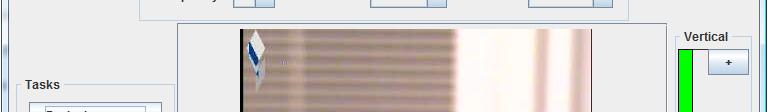
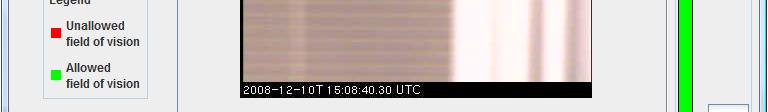
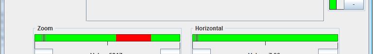
48 SPS 48
49 Need for SPS 49 Tasking sensors so that they deliver the required data (e.g. setting pan, tilt and zoom parameters of a camera) Checking through a standardized interface if sensors will be able to perform certain tasks now or in the future (e.g. investigating if a satellite will cover a certain area during a time period that is of interest)
50 Introduction 50 Standardized interface for tasking sensors and sensor systems Task management Defining tasks Checking tasks Updating/modifying g takss Cancelling tasks Does not archive the data itself points to access points for the data
51 Introduction 51 Usage: Parameterization of: Sensors Simulations Planning and executing of: UAVs Robots Satellites Asynchronous communication with clients that submit tasks via WNS (e.g. notification if a task is completed)
52 Operations 52 Mandatory in SPS 1.0 and 2.0 GetCapabilities: Request a self description of a SPS instance DescribeTasking: Request which information is needed for submitting a task Submit: Submitting tasks DescribeResultAccess: Request information where the data resulting of a task can be retrieved
53 Operations 53 Optional in SPS 1.0 and mandatory in SPS 2.0 GetStatus: Request status information about a task Missing in SPS 1.0 and mandatory in SPS 2.0 DescribeSensor: Retrieving the description of a sensor GetTask: Request complete information about a task
54 Operations 54 Optional GetFeasibility: Check if a task can be executed before submitting it to the SPS Update: Change the parameters of a task Cancel: Cancel a task that was submitted Missing in SPS 1.0 and optional in SPS 2.0 Reserve: Reserving a task Confirm: Execute a reserved task UpdateSensorDescription: Updating the description of a sensor


55 SPS workflow 55
56 Controllable Camera 56 AXIS Pan-Tilt-Zoom Camera SPS for setting the pan, tilt and zoom parameters Additional feature: Block specific parts of the field of view (e.g. for privacy reasons)


57 Controllable Camera 57
58 Thank you for your Attention! 58 Questions? Contact: More information: i h
Extension of INSPIRE Download Services TG for Observation Data
 Extension of INSPIRE Download Services TG for Observation Data Simon Jirka (52 North) 14 th June 2014, MIG Workshop on WCS-based INSPIRE Download Services Agenda Motivation Sensor Web Proposed Update for
Proposed update of Technical Guidance for INSPIRE Download services based on SOS
 Proposed update of Technical Guidance for INSPIRE Download services based on SOS Organised by: Simon Jirka, Alexander Kotsev, Michael Lutz Dr. Simon Jirka (jirka@52north.org) 52 North GmbH Workshop - The
INSPIRE Download Service
 The OGC SOS as INSPIRE Download Service for (meteorological) l) Observation Data Simon Jirka (52 North) 29 th October 2014 5th Workshop on the use of GIS/OGC standards in meteorology Offenbach (Germany)
Using the OGC SOS as INSPIRE Download Service for Observation Data
 Using the OGC SOS as INSPIRE Download Service for Observation Data Simon Jirka (52 North) Alexander Kotsev (JRC) Michael Lutz (JRC) Matthes Rieke (52 North) Robin Smith (JRC) Paul Smits (JRC) 18 th June
Sensor Web when sensor networks meet the World-Wide Web
 Sensor Web when sensor networks meet the World-Wide Web Dr. Steve Liang Assistant Professor Department of Geomatics Engineering Schulich School of Engineering University of Calgary steve.liang@ucalgary.ca
Semantic web based Sensor Planning Services (SPS) for Sensor Web Enablement (SWE)
 for Sensor Web Enablement (SWE)") Semantic web based Sensor Planning Services (SPS) for Sensor Web Enablement (SWE) P.Udayakumar 1, M.Indhumathi 2 1 Teaching Fellow,Department of Computer Technology, MIT Campus, Anna University Chennai,
Semantic web based Sensor Planning Services (SPS) for Sensor Web Enablement (SWE) P.Udayakumar 1, M.Indhumathi 2 1 Teaching Fellow,Department of Computer Technology, MIT Campus, Anna University Chennai,
Monitoring the Environment with Sensor Web Services
 EnviroInfo 2009 (Berlin) Environmental Informatics and Industrial Environmental Protection: Concepts, Methods and Tools Monitoring the Environment with Sensor Web Services Simon Jirka 1, Dr. Albert Remke
OGC Sensor Observation Service 2.0 Hydrology Profile
 Open Geospatial Consortium Submission Date: 2014-05-15 Approval Date: 2014-09-19 Publication Date: 2014-10-20 External identifier of this OGC document: http://www.opengis.net/doc/bp/sos-hydrology/1.0 Internal
Empirical Study of Sensor Observation Services Server Instances
 Empirical Study of Sensor Observation Services Server Instances Alain Tamayo, Pablo Viciano, Carlos Granell, Joaquín Huerta Institute of New Imaging Technologies Universitat Jaume I, Spain Av. Vicent Sos
OGC RESTful encoding of OGC Sensor Planning Service for Earth Observation satellite Tasking
 Open Geospatial Consortium Submission Date: 2014-02-24 Approval Date: 2014-07-10 Publication Date: 2014-07-17 External identifier of this OGC document: http://www.opengis.net/def/bp/rest-sps-for-eo-tasking/1.0
DI proposed a sensor Web and virtual sensor definitions
 IEEE SENSORS JOURNAL, VOL. 11, NO. 6, JUNE 2011 1429 A Flexible Data and Sensor Planning Service for Virtual Sensors Based on Web Service Zeqiang Chen, Nengcheng Chen, Liping Di, Senior Member, IEEE, and
Sensor Web Technology for Sharing Hydrological Measurement Data
 Sensor Web Technology for Sharing Hydrological Measurement Data IHW-netwerkdag 2017 Simon Jirka (jirka@52north.org) Sharing Hydrological Measurement Data Sensors capture a multitude of in-situ data relevant
REST INTERFACE FOR PUB/SUB
 REST INTERFACE FOR PUB/SUB Design and Practical Examples Matthes Rieke AGILE 2017 Workshop Event-based Dissemination and Processing of Geospatial Information Wageningen, 2017-05-09 1. PubSub Concepts 2.
Handbook of Research on Developments and Trends in Wireless Sensor Networks: From Principle to Practice
 Handbook of Research on Developments and Trends in Wireless Sensor Networks: From Principle to Practice Hai Jin Huazhong University of Science and Technology, China Wenbin Jiang Huazhong University of
OGC PUB/SUB Aka OGC Publish/Subscribe Interface Standard 1.0
 OGC PUB/SUB Aka OGC Publish/Subscribe Interface Standard 1.0 Lorenzo Bigagli National Research Council of Italy Institute of Atmospheric Pollution Research (CNR-IIA), Italy Event-based Dissemination and
HMA-T SPS I/F SYSTEM REQUIREMENTS DOCUMENT
 Heterogeneous Missions Accessibility Testbed Sensor Planning Systems Interface HMA-T SPS I/F SYSTEM REQUIREMENTS DOCUMENT Prepared by Name Function Signature Reuben Wright (DMS) Ph. Mérigot (Spot Image)
ISTSOS: INVESTIGATION OF THE SENSOR OBSERVATION SERVICE
 ISTSOS: INVESTIGATION OF THE SENSOR OBSERVATION SERVICE M. Cannata a, *, M. Antonovic a a Institute of Earth sciences, Dept. of Environment, Constructions and Design, University of Applied Sciences of
Open Geospatial Consortium
 Open Geospatial Consortium Date: 2011-03-21 Reference number of this document: OGC 09-001 OGC name of this OGC project document: http://www.opengis.net/doc/is/swes/2.0 Version: 2.0 Category: OpenGIS Implementation
Desarrollo de una herramienta de visualización de datos oceanográficos: Modelos y Observaciones
 Desarrollo de una herramienta de visualización de datos oceanográficos: Modelos y Observaciones J. Fernandez, J. Lopez, I. Carlos, F. Jerez, F. Hermosilla, M. Espino SIMO, LIM-UPC, CIIRC FIELD_AC 7 th
Open Geospatial Consortium
 Open Geospatial Consortium Publication Date: 2018-04-23 Approval Date: 2016-06-23 Posted Date: 2016-06-08 Reference number of this document: OGC 15-118r1 Reference URL for this document: http://www.opengis.net/doc/per/imis-profile-recs4-ows
Open Geospatial Consortium
 Open Geospatial Consortium Date:2011-11-23 Reference number of this document: OGC 11-088r1 Category: Public Discussion Paper Editors:Johannes Echterhoff, Thomas Everding OGC Event Service - Review and
Download Service Implementing Rule and Technical Guidance
 Download and Transformation Draft Implementing Rules Presentation for INSPIRE Initiatives Download Service Implementing Rule and Technical Guidance Olaf Østensen Statens kartverk Norwegian Mapping Authority
GVSOS: A NEW CLIENT FOR OGC SOS INTERFACE STANDARD. Alain Tamayo Fong
 GVSOS: A NEW CLIENT FOR OGC SOS INTERFACE STANDARD Alain Tamayo Fong i GVSOS: A NEW CLIENT FOR OGC SOS INTERFACE STANDARD Dissertation supervised by PhD Joaquín Huerta PhD Fernando Bacao Laura Díaz March,
Observation trends: Expectations from European Comission regarding data exchange and interoperability
 Observation trends: Expectations from European Comission regarding data exchange and interoperability Marcin Wichorowski (IO PAN), Sławomir Sagan (IO PAN), Declan Dunne (UCC MaREI), John Barton (UCC-TYNDALL)
SANY Fusion and Modelling Architecture
 Open Geospatial Consortium Inc. Date: 2010-03-22 Reference number of this OGC project document: OGC 10-001 Version: 1 (Rev 1.2) Category: OGC Discussion Paper Editor: Stuart E. Middleton (Ed.) SANY Fusion
GENeric European Sustainable Information Space for Environment.
 GENeric European Sustainable Information Space for Environment http://www.genesis-fp7.eu/ Outline Introduction The GENESIS FP7 project The GENESIS solution s architecture GENESIS experience with INSPIRE
Semantically enhancing SensorML with controlled vocabularies in the marine domain
 Semantically enhancing SensorML with controlled vocabularies in the marine domain KOKKINAKI ALEXANDRA, BUCK JUSTIN, DARROCH LOUISE, JIRKA SIMON AND THE MARINE PROFILES FOR OGC SENSOR WEB ENABLEMENT STANDARDS
Oracle Spatial User Conference! May 19, 2011 Ronald Reagan Building and International Trade Center Washington, DC USA
 ! May 19, 2011 Ronald Reagan Building and International Trade Center Washington, DC USA Matt McCue Application Architect/Developer Woolpert Inc. Joseph Seppi Program Manager Woolpert Inc. Challenges and
Heterogeneous Missions Accessibility: Interoperability for Earth Observation
 Heterogeneous Missions Accessibility: Interoperability for Earth Observation Pier Giorgio Marchetti - European Space Agency pier.giorgio.marchetti@esa.int Slide 1 EO missions Earth Explorer Global Challenges
Network Based Hard/Soft Information Fusion Network Architecture/SOA J. Rimland
 Network Based Hard/Soft Information Fusion Network Architecture/SOA J. Rimland Objectives: Develop, demonstrate and evaluate an information architecture, cyber-infrastructure, data standards and tools
Documentation of. RESTful SOS
 Documentation of RESTful SOS Document Change Control Revision Date Of Issue Author(s) Brief Description Of Changes 0.1 16.10.12 Eike Hinderk Jürrens Initialization 0.2 17.10.12 Eike Hinderk Jürrens Revision
Using a Sensor Observation Service (SOS) for E1a and E2a
 for E1a and E2a") Using a Sensor Observation Service (SOS) for E1a and E2a Olav Peeters Belgian Interregional Environment Agency (IRCEL CELINE) Content SOS what is this? SOS and the IPR schema Development of an IPR compliant
Using a Sensor Observation Service (SOS) for E1a and E2a Olav Peeters Belgian Interregional Environment Agency (IRCEL CELINE) Content SOS what is this? SOS and the IPR schema Development of an IPR compliant
Providing INSPIRE measurement data. K. Schleidt, S. Grellet, A. Sarretta, P. Tagliolato, A. Kotsev
 Providing INSPIRE measurement data K. Schleidt, S. Grellet, A. Sarretta, P. Tagliolato, A. Kotsev Part 1. Introduction Context 10 years ago o Geospatial information was hardly (if at all) exchanged in
This article appeared in a journal published by Elsevier. The attached copy is furnished to the author for internal non-commercial research and
 This article appeared in a journal published by Elsevier. The attached copy is furnished to the author for internal non-commercial research and education use, including for instruction at the authors institution
Unifying Hydrological Time Series Data for a Global Water Portal
 Unifying Hydrological Time Series Data for a Global Water Portal Pathai Suwannawiwat Chayakorn Netramai The Sirindhorn International Thai-German Graduate School of Engineering King Mongkut s University
INTEGRATION OF DISASTER EVENT DATA INTO SPATIAL DATA INFRASTRUCTURES
 INTEGRATION OF DISASTER EVENT DATA INTO SPATIAL DATA INFRASTRUCTURES B. Stollberg a, *, T. De Groeve a, A. Hirner a, L. Vernaccini a, S. Paris a a Joint Research Centre of the European Commission, Institute
Chapter 17 Web Services Additional Topics
 Prof. Dr.-Ing. Stefan Deßloch AG Heterogene Informationssysteme Geb. 36, Raum 329 Tel. 0631/205 3275 dessloch@informatik.uni-kl.de Chapter 17 Web Services Additional Topics Prof. Dr.-Ing. Stefan Deßloch
GVSOS: A NEW CLIENT FOR OGC SENSOR OBSERVATION SERVICE INTERFACE STANDARD
 GVSOS: A NEW CLIENT FOR OGC SENSOR OBSERVATION SERVICE INTERFACE STANDARD Alain Tamayo, Joaquín Huerta, Carlos Granell, Laura Díaz, Ricardo Quirós Department of Information Systems Universitat Jaume I,
Enterprise SOA Experience Workshop. Module 8: Operating an enterprise SOA Landscape
 Enterprise SOA Experience Workshop Module 8: Operating an enterprise SOA Landscape Agenda 1. Authentication and Authorization 2. Web Services and Security 3. Web Services and Change Management 4. Summary
EXTRA Examples of OGC standards in support of health applications
 EXTRA Examples of OGC standards in support of health applications Some prior / existing initiatives using OGC Standards EU INSPIRE (health and safety working group) GEOSS AIP, EO2Heaven project: EO2HEAVEN
Open Geospatial Consortium Inc.
 Open Geospatial Consortium Inc. Date: 2010-08-27 Reference number of this document: OGC XXXX OGC name of this OGC project document: XXXXXX Version: 1.0.0 Category: Discussion Paper Editor: SOS Usage Profile
LifeWatch/EnvEurope User Forum Use Case Ecology
 LifeWatch/EnvEurope User Forum Use Case Ecology User Forum Barcelona, March 2012 Michael Mirtl (EAA, Environment Agency Austria) Wouter Los (LifeWatch) Infrastructure for Biodiversity and Ecosystem Research
Hydrological Sensor Networks in Germany - Introducing SensorWeb-WSV
 18 th World IMACS / MODSIM Congress, Cairns, Australia 13-17 July 2009 http://mssanz.org.au/modsim09 Hydrological Sensor Networks in Germany - Introducing SensorWeb-WSV Michl, C. 1,2, R. Klipp 1 and M.
Hypermedia Web API for enhanced Heterogeneous Missions Accessibility
 Hypermedia Web API for enhanced Heterogeneous Missions Accessibility Y. Coene, Spacebel s.a. Frascati, June 30, 2015 Page 1 Outline Architecture trends REST Hypermedia API Aspects of Hypermedia API REST:
Pervasive Monitoring - An Intelligent Sensor Pod Approach for Standardised Measurement Infrastructures
 Pervasive Monitoring - An Intelligent Sensor Pod Approach for Standardised Measurement Infrastructures The MIT Faculty has made this article openly available. Please share how this access benefits you.
SERVO - ACES Abstract
 1 of 6 12/27/2004 2:33 PM 2 of 6 12/27/2004 2:33 PM Implementing GIS Grid Services for the International Solid Earth Research Virtual Observatory Galip Aydin (1), Marlon Pierce (1), Geoffrey Fox (1), Mehmet
Asynchronous Geospatial Processing: An Event-Driven Push-Based Architecture for the OGC Web Processing Service
 bs_bs_banner Research Article Transactions in GIS, 2014, ( ): Asynchronous Geospatial Processing: An Event-Driven Push-Based Architecture for the OGC Web Processing Service Rene Westerholt* and Bernd Resch*
Oracle SOA Suite 11g: Build Composite Applications
 Oracle University Contact Us: 1.800.529.0165 Oracle SOA Suite 11g: Build Composite Applications Duration: 5 Days What you will learn This course covers designing and developing SOA composite applications
A Sensor Data Mediator Bridging the OGC Sensor Observation Service (SOS) and the OASIS Open Data Protocol (OData)
 and the OASIS Open Data Protocol (OData)") A Sensor Data Mediator Bridging the OGC Sensor Observation Service (SOS) and the OASIS Open Data Protocol (OData) Chih-Yuan Huang 1, Steve Liang 1, and Yan Xu 2 1 Department of Geomatics Engineering, University
A Sensor Data Mediator Bridging the OGC Sensor Observation Service (SOS) and the OASIS Open Data Protocol (OData) Chih-Yuan Huang 1, Steve Liang 1, and Yan Xu 2 1 Department of Geomatics Engineering, University
Open Geospatial Consortium Inc.
 Open Geospatial Consortium Inc. Date: 2007-12-14 Reference number of this document: OGC 07-018r2 Version: 0.9.5 Category: OGC Best Practice paper Editor: Philippe Mérigot, Spot Image OpenGIS Sensor Planning
Leveraging OGC Services in ArcGIS Server. Satish Sankaran, Esri Yingqi Tang, Esri
 Leveraging OGC Services in ArcGIS Server Satish Sankaran, Esri Yingqi Tang, Esri GIS Creating and Managing Geo Information Products - Proprietary - Open Specifications - Standards Dissemination of Geo
Sensors & Transducers 2015 by IFSA Publishing, S. L.
 Sensors & Transducers 2015 by IFSA Publishing, S. L. http://www.sensorsportal.com Integrating Sensor Data Using Sensor Observation Service: Towards a Methodology for the O-Life Observatory 1, 3 Hicham
Open Geospatial Consortium Inc.
 Open Geospatial Consortium Inc. Date: 2009-03-24 Reference number of this document: OGC 07-018r3 Version: 2.0 draft Category: OpenGIS Implementation Specification Profile Editors: Philippe Mérigot (Spot
A Comparative Study of Web Services-based Event Notification Specifications
 A Comparative Study of Web Services-based Event tification Specifications Yi Huang and Dennis Gannon Extreme! Computing Lab Dept. of Computer Science Indiana University Event tification Systems Enable
Serving Large-Scale Coverages - How to Tame an Elephant
 Serving Large-Scale s - How to Tame an Elephant OGC Workshop 2 INSPIRE Conference Edinburgh, 29-jun-2011 Peter Baumann Jacobs University rasdaman GmbH OGC WCS.SWG chair OGC spec editor Sensor & Image Data
Towards operational agility using service oriented integration of prototype and legacy systems
 Towards operational agility using service oriented integration of prototype and legacy systems Authors: Frank T. Johnsen, Trude H. Bloebaum, Ketil Lund, and Espen Skjervold Norwegian Defence Research Establishment
Leveraging OGC Services in ArcGIS Server. Satish Sankaran Yingqi Tang
 Leveraging OGC Services in ArcGIS Server Satish Sankaran ssankaran@esri.com Yingqi Tang ytang@esri.com Agenda Interoperability Enablers OGC and esri OGC Web Services ArcGIS and OGC Web Services - @ version
Knowledge Bases in Spatial Data Infrastructures A new Level of Decision Support
 Knowledge Bases in Spatial Data Infrastructures A new Level of Decision Support Ingo Simonis 1,Andreas W ytzisk 2 1 Institute for Geoinform atics,university of Muenster,Germ any Tel:+49-251-83-33084,Fax:
Open Geospatial Consortium Inc.
 Open Geospatial Consortium Inc. Date: 2005-10-10 Reference number of this OGC document: Version: 0.2.0 Category: OpenGIS Discussion Paper Editor: Ingo Simonis OpenGIS Sensor Alert Service Implementation
DGIWG 122. DGIWG - Web Feature Service 2.0 Profile
 DGIWG 122 DGIWG - Web Feature Service 2.0 Profile Document type: Standard Document subtype: Implementation Profile Document date: 16 November 2015 Edition number: 2.0.0 Supersedes: This document supersedes
OGC Collaborative Platform Undercover
 OGC Collaborative Platform Undercover AGU Fall Meeting 2012 Dec 7, 2012 Greg Buehler; David Arctur; Luis E. Bermudez Open Geospatial Consortium 475 volunteer organizations 4307 Users 60 Standards 2 OGC
How s your Sports ESP? Using SAS Event Stream Processing with SAS Visual Analytics to Analyze Sports Data
 Paper SAS638-2017 How s your Sports ESP? Using SAS Event Stream Processing with SAS Visual Analytics to Analyze Sports Data ABSTRACT John Davis, SAS Institute Inc. In today's instant information society,
Florida Coastal Everglades LTER Program
 Florida Coastal Everglades LTER Program Metadata Workshop April 13, 2007 Linda Powell, FCE Information Manager Workshop Objectives I. Short Introduction to the FCE Metadata Policy What needs to be submitted
Air Quality & e-reporting from the perspective of Belgium
 Air Quality & e-reporting from the perspective of Belgium Olav Peeters Belgian Interregional Environment Agency (IRCEL CELINE) Content Who are we (IRCEL CELINE) and what do we do? E-reporting from our
Sensor Data Management
 Wright State University CORE Scholar Kno.e.sis Publications The Ohio Center of Excellence in Knowledge- Enabled Computing (Kno.e.sis) 8-14-2007 Sensor Data Management Cory Andrew Henson Wright State University
A service oriented approach for geographical data sharing
 I3E 2005 Conference October 28-30, 2005" A service oriented approach for geographical data sharing Authors L. Vaccari 1, A. Ivanyuckovich 2, and M. Marchese 2 1 Autonomous Province of Trento, Trento, Italy
Implementation and Evaluation of Four Interoperable Open Standards for the Internet of Things
 Sensors 2015, 15, 24343-24373; doi:10.3390/s150924343 Article OPEN ACCESS sensors ISSN 1424-8220 www.mdpi.com/journal/sensors Implementation and Evaluation of Four Interoperable Open Standards for the
Open Geospatial Consortium Inc.
 Open Geospatial Consortium Inc. Date: 2010-02-15 Reference number of this OpenGIS Project Document: OGC 09-147 Version: 0.0.1 Category: OpenGIS Interface Standard Editor: Peter Baumann WCS Extension --
ESRI & Interoperability. David Danko ISO TC 211 Metadata Project Leader OGC Metadata WG Chair ESRI Senior Consultant GIS Standards
 ESRI & Interoperability David Danko ISO TC 211 Metadata Project Leader OGC Metadata WG Chair ESRI Senior Consultant GIS Standards ddanko@esri.com GIS has always required Interoperability Social Factors
Enabling Embedded Systems to access Internet Resources
 Enabling Embedded Systems to access Internet Resources Embedded Internet Book www.embeddedinternet.org 2 Agenda : RATIONALE Web Services: INTRODUCTION HTTP Protocol: REVIEW HTTP Protocol Bindings Testing
The GIGAS Methodology
 The GIGAS Methodology Pier Giorgio Marchetti European Space Agency Earth Observation Programme Ground Segment Department pier.giorgio.marchetti@esa.int GIGAS Objectives GIGAS has the goal to promote the
Open Geospatial Consortium
 Open Geospatial Consortium Date: 2010-10-12 Reference number of this document: Category: Public Discussion Paper Editor(s): Simon Jirka, Arne Bröring, Daniel Nüst OGC Sensor Observable Registry (SOR) Discussion
OGC WCS 2.0 Revision Notes
 Open Geospatial Consortium Inc. Date: 2010-02-15 Reference number of this document: Version: 1.0.0 Category: OpenGIS IS Revision Notes Editors: Peter Baumann, Steven Keens OGC WCS 2.0 Revision Notes Copyright
ISO INTERNATIONAL STANDARD. Geographic information Filter encoding. Information géographique Codage de filtres. First edition
 INTERNATIONAL STANDARD ISO 19143 First edition 2010-10-15 Geographic information Filter encoding Information géographique Codage de filtres Reference number ISO 19143:2010(E) ISO 2010 PDF disclaimer This
ELENA: Creating a Smart Space for Learning. Zoltán Miklós (presenter) Bernd Simon Vienna University of Economics
 Bernd Simon Vienna University of Economics") ELENA: Creating a Smart Space for Learning Zoltán Miklós (presenter) Bernd Simon Vienna University of Economics Overview Motivation, goals Architecture, implementation Interoperability: Querying resources
ELENA: Creating a Smart Space for Learning Zoltán Miklós (presenter) Bernd Simon Vienna University of Economics Overview Motivation, goals Architecture, implementation Interoperability: Querying resources
OGC Open Geospatial Consortium (OGC)
") OGC Open Geospatial Consortium (OGC) Request for Quotations (RFQ) and Call for Participation (CFP) for OGC Web Services Initiative - Phase 9 (OWS-9) Annex A OWS-9 WBS and Work Items RFQ Issuance Date:
OGC Open Geospatial Consortium (OGC) Request for Quotations (RFQ) and Call for Participation (CFP) for OGC Web Services Initiative - Phase 9 (OWS-9) Annex A OWS-9 WBS and Work Items RFQ Issuance Date:
Big Data Earth Observation Standardization elements Codrina Ilie TERRASIGNA TF7/SG5
 Big Data Earth Observation Standardization elements Codrina Ilie TERRASIGNA TF7/SG5 1 Earth Observation standardization intro 2 directions: 1. standardization of the Ground Segment Services: Heterogeneous
Motions from the 91st OGC Technical and Planning Committee Meetings Geneva, Switzerland Contents
 Motions from the 91st OGC Technical and Planning Committee Meetings Geneva, Switzerland Contents "The Open Geospatial Consortium and EarthCube White Paper... 2 Vote for OGC Sensor Observation Service 2.0
ONVIF Device IO Client Test Specification
 ONVIF Device IO Client Test Specification Version 17.12 December 2017 www.onvif.org 2017 ONVIF, Inc. All rights reserved. Recipients of this document may copy, distribute, publish, or display this document
MASTER THESIS. Automation of data processing in the network of geospatial web services
 BLEKINGE INSTITUTE OF TECHNOLOGY School of Computer Science MASTER THESIS Automation of data processing in the network of geospatial web services AUTHOR: Dawid Nejman SUPERVISORS: Ph.D Tomasz Kubik Ph.D
Challenges. Distribution. Discovery. Security. Usability. Governance. Unreliable messaging. Physical objects. Dealing with places.
 Unreliable messaging Distribution Discovery Physical objects Asynchrony Dealing with places Delay tolerance Challenges Power source? Data services Security Identifying Integrity Autonomy Usability Provenance
Introduction to INSPIRE. Network Services
 Introduction to INSPIRE. Network Services European Commission Joint Research Centre Institute for Environment and Sustainability Digital Earth and Reference Data Unit www.jrc.ec.europa.eu Serving society
Oracle SOA Suite 12c : Build Composite Applications
 Oracle University Contact Us: Local: 1800 103 4775 Intl: +91 80 67863102 Oracle SOA Suite 12c : Build Composite Applications Duration: 5 Days What you will learn This course teaches you to design and develop
Leveraging OGC Services in ArcGIS Server
 Esri International User Conference San Diego, CA Technical Workshops Jul.14 th 2011 Leveraging OGC Services in ArcGIS Server Satish Sankaran Yingqi Tang Agenda Interoperability
Service Interface Design RSVZ / INASTI 12 July 2006
 Architectural Guidelines Service Interface Design RSVZ / INASTI 12 July 2006 Agenda > Mandatory standards > Web Service Styles and Usages > Service interface design > Service versioning > Securing Web
The CEDA Web Processing Service for rapid deployment of earth system data services
 The CEDA Web Processing Service for rapid deployment of earth system data services Stephen Pascoe Ag Stephens Phil Kershaw Centre of Environmental Data Archival 1 1 Overview of CEDA-WPS History first implementation
Sensor Web Enablement. Installation Guide for Sensor Observation Service with Generalizer, Diagram and KML extension Version 2.0
 Installation Guide for Sensor Observation Service with Generalizer, Diagram and KML extension Version 2.0 Revision Number Document Change Control Date Of Issue Author(s) Brief Description Of Changes 0.1
Distribution and web services
 Chair of Software Engineering Carlo A. Furia, Bertrand Meyer Distribution and web services From concurrent to distributed systems Node configuration Multiprocessor Multicomputer Distributed system CPU
Oracle SOA Suite 10g: Services Orchestration
 Oracle University Contact Us: 01 800 214 0697 Oracle SOA Suite 10g: Services Orchestration Duration: 5 Days What you will learn This course deals with the basic concepts of Service Orchestration (SOA)
Title: Author(s)/Organisation(s): Working Group: References: Quality Assurance: A5.2-D3 [3.7] Information Grounding Service Component Specification
![Title: Author(s)/Organisation(s): Working Group: References: Quality Assurance: A5.2-D3 [3.7] Information Grounding Service Component Specification](/thumbs/80/81830659.jpg "Title: Author(s)/Organisation(s): Working Group: References: Quality Assurance: A5.2-D3 [3.7] Information Grounding Service Component Specification") Title: A5.2-D3 [3.7] Information Grounding Service Component Specification Author(s)/Organisation(s): Ana Belén Antón/ETRA Working Group: Architecture Team/WP05 References: A1.8-D5 User Involvement Document,
Title: A5.2-D3 [3.7] Information Grounding Service Component Specification Author(s)/Organisation(s): Ana Belén Antón/ETRA Working Group: Architecture Team/WP05 References: A1.8-D5 User Involvement Document,
Implementation Method of OGC Web Map Service Based on Web Service. Anthony Wenjue Jia *,Yumin Chen *,Jianya Gong * *Wuhan University
 Implementation Method of OGC Web Map Service Based on Web Service Anthony Wenjue Jia *,Yumin Chen *,Jianya Gong * *Wuhan University ABSTRACT The most important advantage of web service is the multi-platform,
Oracle SOA Suite 11g: Build Composite Applications
 Oracle University Contact Us: Landline: +91 80 67863899 Toll Free: 0008004401672 Oracle SOA Suite 11g: Build Composite Applications Duration: 5 Days What you will learn This course teaches you to design
DGIWG Web Feature Service 2.0 Profile
 Open Geospatial Consortium Submission Date: 2015-02-10 Approval Date: 2015-05-29 Publication Date: 2016-02-01 External identifier of this OGC document:
Service metadata validation in Spatineo Monitor
 Service metadata validation in Spatineo Monitor Ilkka Rinne Spatineo Inc. INSPIRE MIG validation workshop JRC/Ispra, 15th & 16th May 2014 Spatineo Linnankoskenkatu 16 A 17 FI-00250 Helsinki +358 20 703
OGC : Sensor Web Enablement Application for Debris Flow Monitoring System in Taiwan
 Open Geospatial Consortium Inc. Date: 2009-11-19 Reference number of this document: OGC 09-082r2 Version: 0.2.0 Category: OGC Best Practice Editors: Hsu-Chun James Yu Zhong-Hung Lee Cai-Fang Ye Lan-Kun
Oracle SOA Suite 12c: Build Composite Applications
 Oracle University Contact Us: Landline: +91 80 67863899 Toll Free: 0008004401672 Oracle SOA Suite 12c: Build Composite Applications Duration: 5 Days What you will learn This Oracle SOA Suite 12c: Build
Open Geospatial Consortium Inc.
 Open Geospatial Consortium Inc. Date: 2007-08-02 Reference number of this document: OGC 07-014r3 Version: 1.0 Category: OpenGIS Implementation Specification Editor: Ingo Simonis, University of Muenster
Axis2 Tutorial. Chathura Herath, Eran Chinthaka. Lanka Software Foundation and Apache Software Foundation
 Axis2 Tutorial Chathura Herath, Eran Chinthaka Lanka Software Foundation and Apache Software Foundation Overview Introduction Installation Client demonstration - Accessing existing endpoint Implementing
WWW, REST, and Web Services
 WWW, REST, and Web Services Instructor: Yongjie Zheng Aprile 18, 2017 CS 5553: Software Architecture and Design World Wide Web (WWW) What is the Web? What challenges does the Web have to address? 2 What
Spatial Data on the Web
 Spatial Data on the Web Tools and guidance for data providers The European Commission s science and knowledge service W3C Data on the Web Best Practices 35 W3C/OGC Spatial Data on the Web Best Practices