Sensor Data Management
|
|
|
- Christian Knight
- 5 years ago
- Views:
Transcription

1 Wright State University CORE Scholar Kno.e.sis Publications The Ohio Center of Excellence in Knowledge- Enabled Computing (Kno.e.sis) Sensor Data Management Cory Andrew Henson Wright State University - Main Campus Follow this and additional works at: Part of the Bioinformatics Commons, Communication Technology and New Media Commons, Databases and Information Systems Commons, OS and Networks Commons, and the Science and Technology Studies Commons Repository Citation Henson, C. A. (2007). Sensor Data Management.. This Presentation is brought to you for free and open access by the The Ohio Center of Excellence in Knowledge-Enabled Computing (Kno.e.sis) at CORE Scholar. It has been accepted for inclusion in Kno.e.sis Publications by an authorized administrator of CORE Scholar. For more information, please contact corescholar@
2 1
3 Sensor Data Management 2
4 Presentation Outline 1. Motivating Scenario 2. Sensor Web Enablement 3. Sensor data evolution hierarchy 4. Semantic Analysis 3
 Low-level Sensor")

 How do we determine if E-H =")
 How do we determine if E-H or")
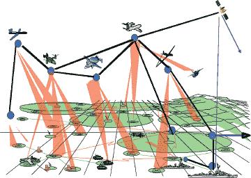
5 Motivating Scenario High-level Sensor (S-H) Low-level Sensor (S-L) H L A-H E-H A-L E-L How do we determine if A-H = A-L? (Same time? Same place?) How do we determine if E-H = E-L? (Same entity?) How do we determine if E-H or E-L constitutes a threat? 4
6 The Challenge Collection and analysis of information from heterogeneous multi-layer sensor nodes 5
7 Why is this a Challenge? There is a lack of uniform operations and standard representation for sensor data. There exists no means for resource reallocation and resource sharing. Deployment and usage of resources is usually tightly coupled with the specific location, application, and devices employed. Resulting in a lack of interoperability. 6
8 The Solution The Open Geospatial Consortium Sensor Web Enablement Framework 7
9 Presentation Outline 1. Motivating Scenario 2. Sensor Web Enablement 3. Sensor data evolution hierarchy 4. Semantic Analysis 8

10 Open Geospatial Consortium Consortium of 330+ companies, government agencies, and academic institutes Open Standards development by consensus process Interoperability Programs provide end-to-end implementation and testing before spec approval Standard encodings, e.g. GeographyML, SensorML, Observations & Measurements, TransducerML, etc. Standard Web Service interfaces, e.g. Web Map Service Web Feature Service Web Coverage Service Catalog Service Sensor Web Enablement Services (Sensor Observation Service, Sensor Alert Service, Sensor Process Service, etc.) OGC Mission To lead in the development, promotion and harmonization of open spatial standards 9


11 Sensor Web Enablement Constellations of heterogeneous sensors Vast set of users and applications Satellite Airborne Sensor Web Enablement Weather Surveillance Chemical Detectors Biological Detectors Sea State Distributed self-describing sensors and related servicesnetwork Services Link sensors to network and networkcentric services Common XML encodings, information models, and metadata for sensors and observations Access observation data for value added processing and decision support applications Users on exploitation workstations, web browsers, and mobile devices 10
12 SWE Languages and Encodings Information Model for Observations and Sensing Sensor and Processing Description Language Observations & Measurements (O&M) SensorML (SML) GeographyML (GML) TransducerML (TML) SWE Common Data Structure And Encodings Multiplexed, Real Time Streaming Protocol Sam Bacharach, GML by OGC to AIXM 5 UGM, OGC, Feb. 27,
13 SWE Components - Dictionaries Phenomena Units of Measure Registry Service OGC Catalog Service for the Web (CSW) Sensor Types Applications Sam Bacharach, GML by OGC to AIXM 5 UGM, OGC, Feb. 27,
14 SWE Components Web Services Access Sensor Description and Data Command and Task Sensor Systems Discover Services, Sensors, Providers, Data SOS SPS Catalog Service SAS Dispatch Sensor Alerts to registered Users Clients Accessible from various types of clients from PDAs and Cell Phones to high end Workstations Sam Bacharach, GML by OGC to AIXM 5 UGM, OGC, Feb. 27,
15 Sensor Model Language (SensorML) 14


16 SML Concepts Sensor Mike Botts, "SensorML and Sensor Web Enablement," Earth System Science Center, UAB Huntsville 15


17 SML Concepts Sensor Description Mike Botts, "SensorML and Sensor Web Enablement," Earth System Science Center, UAB Huntsville 16


18 SML Concepts Accuracy and Range Mike Botts, "SensorML and Sensor Web Enablement," Earth System Science Center, UAB Huntsville 17


19 SML Concepts Platform Mike Botts, "SensorML and Sensor Web Enablement," Earth System Science Center, UAB Huntsville 18

20 SML Concepts Process Model In SensorML, everything is modeled as a Process ProcessModel defines atomic process modules (detector being one) has five sections metadata inputs, outputs, parameters method Inputs, outputs, and parameters defined using SWE Common data definitions Mike Botts, "SensorML and Sensor Web Enablement," Earth System Science Center, UAB Huntsville 19

21 SML Concepts Process Process defines a process chain includes: metadata inputs, outputs, and parameters processes (ProcessModel, Process) data sources connections between processes and between processes and data System defines a collection of related processes along with positional information Mike Botts, "SensorML and Sensor Web Enablement," Earth System Science Center, UAB Huntsville 20
22 SML Concepts Metadata Group Metadata is primarily for discovery and assistance, and not typically used within process execution Includes Identification, classification, description Security, legal, and time constraints Capabilities and characteristics Contacts and documentation History Mike Botts, "SensorML and Sensor Web Enablement," Earth System Science Center, UAB Huntsville 21
23 Presentation Outline 1. Motivating Scenario 2. Sensor Web Enablement 3. Sensor data evolution hierarchy 4. Semantic Analysis 22

24 Data Pyramid 23
25 Data Pyramid Sensor Data Pyramid Ontology Metadata Entity Metadata Feature Metadata Knowledge Information Raw Sensor (Phenomenological) Data Data 24
26 Sensor Data Pyramid Challenges Avalanche of data Streaming data Multi-modal/level data fusion Lack of interoperability Ontology Metadata Entity Metadata Feature Metadata Raw Sensor Data Solution Goal 1. Collect data from network of multi-level, multi-modal, heterogeneous sensors 2. Annotate streaming sensor data with TransducerML and utilize metadata to enable data fusion 3. Use SensorML to model sensor infrastructure and data processes 4. Annotate sensor data with SensorML 5. Store sensor metadata in XML database 6. Query sensor metadata with XQuery 25
27 Sensor Data Pyramid Challenges Extract features from data Annotate data with features Store and query feature metadata Ontology Metadata Entity Metadata Feature Metadata Solution Goal 1. Use O&M to model observations and measurements 2. Annotate sensor data with observation and measurement metadata 3. Store sensor metadata in XML database, and query with XQuery Raw Sensor Data 26
28 Sensor Data Pyramid Challenges Detect objects-events from features Annotate data with objects-events Store and query objects-events Ontology Metadata Entity Metadata Feature Metadata Raw Sensor Data Solution Goal 1. Build (or use existing) entity domain ontologies for objects and events 2. Extend SensorML with model-references to object-event ontologies 3. Annotate sensor data with object-event metadata 4. Store sensor metadata in XML database, and query with XQuery 5. Store object-event ontologies as RDF, and query with SPARQL 27
29 Sensor Data Pyramid Challenges Discover and reason over associations: objects and events space and time data provenance Ontology Metadata Entity Metadata Feature Metadata Raw Sensor Data Solution Goal 1. Query knowledge base with SPARQL 2. Object-event analysis to discover interesting events 3. Spatiotemporal analysis to track objects through space-time 4. Provenance Pathway analysis to track information through data life-span 28
30 Sensor Data Architecture Knowledge Analysis Processes Annotation Processes Object-Event Relations Spatiotemporal Associations Provenance Pathways Semantic Analysis SML-S Oracle RDF Entity Detection SML-S Information Entity Metadata Oracle XML Feature Extraction Fusion O&M SML-S Ontologies Object-Event Ontology Feature Metadata TML Space-Time Ontology Collection Data Raw Phenomenological Data Sensors (RF, EO, IR, HIS, acoustic) 29
31 Presentation Outline 1. Motivating Scenario 2. Sensor Web Enablement 3. Sensor data evolution hierarchy 4. Semantic Analysis 30
32 Spatial, Temporal, Thematic Analytics
33 Three Dimensions of Information Thematic Dimension: What Temporal Dimension: When North Korea detonates nuclear device on October 9, 2006 near Kilchu, North Korea Spatial Dimension: Where 32
34 Motivation Semantic Analytics Searching, analyzing and visualizing semantically meaningful connections between named entities Connecting the Dots Applications National Security, Drug Discovery, Medical Informatics Significant progress with thematic data: query operators (semantic associations, subgraph discovery), query languages (SPARQ2L, SPARQLeR), data stores (Brahms) Spatial and Temporal data is critical in many analytical domains Need to support spatial and temporal data and relationships 33
35 Value to Sensor Networks Simple (Analyze Infrastructure): What types of sensors are available? What sensors can observe a particular phenomenon at a given geolocation? Get all observations for a particular geolocation during a given time interval. Complex (More background thematic information): What do I know about vehicle with license plate XYZ123? What do I know about the buildings (georeferenced) in this image? Which sensors cover an area which intersects with a planned Military Convoy? 34
36 rdfs:class Directed Labeled Graph lsdis:person rdfs:literal rdfs:range rdf:property lsdis:speech rdfs:domain lsdis:politician Statement lsdis:nam (triple): <lsdis:politician_123> e <lsdis:gives> <lsdis:speech_456>. Subject lsdis:give Predicate rdfs:range Object rdfs:domain s Statement (triple): <lsdis:politician_123> <lsdis:name> Franklin Roosevelt. Defining Subject Defining Properties: Classes: Predicate Object <lsdis:gives> <lsdis:person> <rdf:type> <rdf:type> <rdf:property> <rdfs:class>.. lsdis:gives lsdis:politician_12 Subject Subject Predicate Predicate Object Object lsdis:speech_456 3 Defining Defining Class/Property Properties Hierarchies: (domain and range): <lsdis:politician> name <lsdis:gives> <rdfs:subclassof> <rdfs:domain> <lsdis:politician> <lsdis:person>.. Subject <lsdis:gives> <rdfs:range> Predicate <lsdis:politician> rdf:type Object. Franklin Roosevelt Subject Predicate rdfs:subclassof Object statement 35
37 Challenges Data Modeling and Querying: Thematic relationships can be directly stated but many spatial and temporal relationships (e.g. distance) are implicit and require additional computation Temporal properties of paths aren t known until query execution time hard to index RDFS Inferencing: If statements have an associated valid time this must be taken into account when performing inferencing (x, rdfs:subclassof, y) : [1, 4] AND (y, rdfs:subclassof, z) : [3, 5] (x, rdfs:subclassof, z) : [3, 4] 36
38 Work to Date Ontology-based model for spatiotemporal data using temporal RDF 1 Illustrated benefits in flexibility, extensibility and expressiveness as compared with existing spatiotemporal models used in GIS Definition, implementation and evaluation of corresponding query operators using an extensible DBMS (Oracle) 2 Created SQL Table Functions which allow SPARQL graph patterns in combination with Spatial and Temporal predicates over Temporal RDF graphs 1. Matthew Perry, Farshad Hakimpour, Amit Sheth. "Analyzing Theme, Space and Time: An Ontology-based Approach", Fourteenth International Symposium on Advances in Geographic Information Systems (ACM-GIS '06), Arlington, VA, November 10-11, Matthew Perry, Amit Sheth, Farshad Hakimpour, Prateek Jain. "What, Where and When: Supporting Semantic, Spatial and Temporal Queries in a DBMS", Kno.e.sis Center Technical Report. KNOESIS-TR , April 22,
39 Example Graph Pattern 38
40 Sample STT Query Scenario (Biochemical Threat Detection): Analysts must examine soldiers symptoms to detect possible biochemical attack Query specifies (1) a relationship between a soldier, a chemical agent and a battle location (2) a relationship between members of an enemy organization and their known locations (3) a spatial filtering condition based on the proximity of the soldier and the enemy group in this context 39
41 Results Small: 100,000 triples Medium: 1.6 Million triples Large: 15 Million triples 40
42 Thank You.
Semantic Sensor Web. CORE Scholar. Wright State University. Amit P. Sheth Wright State University - Main Campus,
 Wright State University CORE Scholar Kno.e.sis Publications The Ohio Center of Excellence in Knowledge- Enabled Computing (Kno.e.sis) 12-17-2008 Semantic Sensor Web Amit P. Sheth Wright State University
Supporting Complex Thematic, Spatial and Temporal Queries over Semantic Web Data
 Supporting Complex Thematic, Spatial and Temporal Queries over Semantic Web Data Matthew Perry 1, Amit P. Sheth 1, Farshad Hakimpour 2, Prateek Jain 1 2 nd International Conference on Geospatial Semantics
Extending SPARQL to Support Spatially and Temporally Related Information
 Wright State University CORE Scholar Kno.e.sis Publications The Ohio Center of Excellence in Knowledge- Enabled Computing (Kno.e.sis) 6-16-2009 Extending SPARQL to Support Spatially and Temporally Related
Semantic Integration of Citizen Sensor Data and Multilevel Sensing: A Comprehensive Path Towards Event Monitoring and Situational Awareness
 Wright State University CORE Scholar Kno.e.sis Publications The Ohio Center of Excellence in Knowledge- Enabled Computing (Kno.e.sis) 2-17-2009 Semantic Integration of Citizen Sensor Data and Multilevel
A Framework to Support Spatial, Temporal and Thematic Analytics over Semantic Web Data
 Wright State University CORE Scholar Kno.e.sis Publications The Ohio Center of Excellence in Knowledge- Enabled Computing (Kno.e.sis) 5-13-2008 A Framework to Support Spatial, Temporal and Thematic Analytics
SPARQL Query Re-Writing for Spatial Datasets Using Partonomy Based Transformation Rules
 Wright State University CORE Scholar Kno.e.sis Publications The Ohio Center of Excellence in Knowledge- Enabled Computing (Kno.e.sis) 12-2009 SPARQL Query Re-Writing for Spatial Datasets Using Partonomy
Semantic web based Sensor Planning Services (SPS) for Sensor Web Enablement (SWE)
 for Sensor Web Enablement (SWE)") Semantic web based Sensor Planning Services (SPS) for Sensor Web Enablement (SWE) P.Udayakumar 1, M.Indhumathi 2 1 Teaching Fellow,Department of Computer Technology, MIT Campus, Anna University Chennai,
Semantic web based Sensor Planning Services (SPS) for Sensor Web Enablement (SWE) P.Udayakumar 1, M.Indhumathi 2 1 Teaching Fellow,Department of Computer Technology, MIT Campus, Anna University Chennai,
A Review for Semantic Sensor Web Research and Applications
 , pp.31-36 http://dx.doi.org/10.14257/astl.2014.48.06 A Review for Semantic Sensor Web Research and Applications Chaoqun Ji, Jin Liu, Xiaofeng Wang College of Information Engineering, Shanghai Maritime
Matthew S. Perry.
 Matthew S. Perry http://knoesis.wright.edu/students/mperry msperry@gmail.com RESEARCH INTERESTS I have broad research interests in database systems, geographic information systems, and the Semantic Web.
Citizen Sensing: Opportunities and Challenges in Mining Social Signals and Perceptions
 Wright State University CORE Scholar Kno.e.sis Publications The Ohio Center of Excellence in Knowledge- Enabled Computing (Kno.e.sis) 7-19-2011 Citizen Sensing: Opportunities and Challenges in Mining Social
SEXTANT 1. Purpose of the Application
 SEXTANT 1. Purpose of the Application Sextant has been used in the domains of Earth Observation and Environment by presenting its browsing and visualization capabilities using a number of link geospatial
{Ontology: Resource} x {Matching : Mapping} x {Schema : Instance} :: Components of the Same Challenge
 Wright State University CORE Scholar Kno.e.sis Publications The Ohio Center of Excellence in Knowledge- Enabled Computing (Kno.e.sis) 11-5-2006 {Ontology: Resource} x {Matching : Mapping} x {Schema : Instance}
Building Virtual Earth Observatories Using Scientific Database, Semantic Web and Linked Geospatial Data Technologies
 Building Virtual Earth Observatories Using Scientific Database, Semantic Web and Linked Geospatial Data Technologies Presenter: George Garbis ggarbis@di.uoa.gr Dept. of Informatics and Telecommunications
Sensor Web when sensor networks meet the World-Wide Web
 Sensor Web when sensor networks meet the World-Wide Web Dr. Steve Liang Assistant Professor Department of Geomatics Engineering Schulich School of Engineering University of Calgary steve.liang@ucalgary.ca
INSPIRE Download Service
 The OGC SOS as INSPIRE Download Service for (meteorological) l) Observation Data Simon Jirka (52 North) 29 th October 2014 5th Workshop on the use of GIS/OGC standards in meteorology Offenbach (Germany)
ON HANDLING GEOGRAPHIC DATA OF PRINT AND DIGITAL FORMS IN ACADEMIC LIBRARIES: THE ROLE OF ONTOLOGIES
 ON HANDLING GEOGRAPHIC DATA OF PRINT AND DIGITAL FORMS IN ACADEMIC LIBRARIES: THE ROLE OF ONTOLOGIES Lila Theodoridou 1, Dimitris Kotzinos 1&2, Zoe Sotiriou 1 1 TEI of Serres, 2 FORTH-ICS Dimitris Kotzinos,
Scaling the Semantic Wall with AllegroGraph and TopBraid Composer. A Joint Webinar by TopQuadrant and Franz
 Scaling the Semantic Wall with AllegroGraph and TopBraid Composer A Joint Webinar by TopQuadrant and Franz Dean Allemang Chief Scientist, TopQuadrant Inc. Jans Aasman CTO, Franz Inc. July 07 1 This Seminar
CORE Scholar. Wright State University. Amit P. Sheth Wright State University - Main Campus,
 Wright State University CORE Scholar Kno.e.sis Publications The Ohio Center of Excellence in Knowledge- Enabled Computing (Kno.e.sis) 9-28-2007 Realizing the Relationship Web: Morphing Information Access
A Framework to Support Spatial, Temporal and Thematic Analytics over Semantic Web Data
 A Framework to Support Spatial, Temporal and Thematic Analytics over Semantic Web Data Matthew S. Perry, Amit P Sheth, Prateek Jain Spatial and temporal data are critical components in many applications.
Using the OGC SOS as INSPIRE Download Service for Observation Data
 Using the OGC SOS as INSPIRE Download Service for Observation Data Simon Jirka (52 North) Alexander Kotsev (JRC) Michael Lutz (JRC) Matthes Rieke (52 North) Robin Smith (JRC) Paul Smits (JRC) 18 th June
Semantic Infrastructure and Platforms for Geospatial Services: A report from European Projects 4 th International Workshop on Semantic and
 Semantic Infrastructure and Platforms for Geospatial Services: A report from European Projects 4 th International Workshop on Semantic and Conceptual Issues in GIS (SeCoGIS 2010) Vancouver, Canada November
Semantic Web Technology Evaluation Ontology (SWETO): A Test Bed for Evaluating Tools and Benchmarking Applications
: A Test Bed for Evaluating Tools and Benchmarking Applications") Wright State University CORE Scholar Kno.e.sis Publications The Ohio Center of Excellence in Knowledge- Enabled Computing (Kno.e.sis) 5-22-2004 Semantic Web Technology Evaluation Ontology (SWETO): A Test
Wright State University CORE Scholar Kno.e.sis Publications The Ohio Center of Excellence in Knowledge- Enabled Computing (Kno.e.sis) 5-22-2004 Semantic Web Technology Evaluation Ontology (SWETO): A Test
Novel System Architectures for Semantic Based Sensor Networks Integraion
 Novel System Architectures for Semantic Based Sensor Networks Integraion Z O R A N B A B O V I C, Z B A B O V I C @ E T F. R S V E L J K O M I L U T N O V I C, V M @ E T F. R S T H E S C H O O L O F T
Observation trends: Expectations from European Comission regarding data exchange and interoperability
 Observation trends: Expectations from European Comission regarding data exchange and interoperability Marcin Wichorowski (IO PAN), Sławomir Sagan (IO PAN), Declan Dunne (UCC MaREI), John Barton (UCC-TYNDALL)
Semantic Web Applications in Industry, Government, Health Care and Life Sciences
 Wright State University CORE Scholar Kno.e.sis Publications The Ohio Center of Excellence in Knowledge- Enabled Computing (Kno.e.sis) 4-18-2007 Semantic Web Applications in Industry, Government, Health
Monitoring the Environment with Sensor Web Services
 EnviroInfo 2009 (Berlin) Environmental Informatics and Industrial Environmental Protection: Concepts, Methods and Tools Monitoring the Environment with Sensor Web Services Simon Jirka 1, Dr. Albert Remke
Interoperability in Science Data: Stories from the Trenches
 Interoperability in Science Data: Stories from the Trenches Karen Stocks University of California San Diego Open Data for Open Science Data Interoperability Microsoft escience Workshop 2012 Interoperability
Semantic Processing of Sensor Event Stream by Using External Knowledge Bases
 Semantic Processing of Sensor Event Stream by Using External Knowledge Bases Short Paper Kia Teymourian and Adrian Paschke Freie Universitaet Berlin, Berlin, Germany {kia, paschke}@inf.fu-berlin.de Abstract.
SA-REST: Using Semantics to Empower RESTful Services and Smashups with Better Interoperability and Mediation
 Wright State University CORE Scholar Kno.e.sis Publications The Ohio Center of Excellence in Knowledge- Enabled Computing (Kno.e.sis) 5-22-2008 SA-REST: Using Semantics to Empower RESTful Services and
Extension of INSPIRE Download Services TG for Observation Data
 Extension of INSPIRE Download Services TG for Observation Data Simon Jirka (52 North) 14 th June 2014, MIG Workshop on WCS-based INSPIRE Download Services Agenda Motivation Sensor Web Proposed Update for
OGC Collaborative Platform Undercover
 OGC Collaborative Platform Undercover AGU Fall Meeting 2012 Dec 7, 2012 Greg Buehler; David Arctur; Luis E. Bermudez Open Geospatial Consortium 475 volunteer organizations 4307 Users 60 Standards 2 OGC
Strabon. Semantic support for EO Data Access in TELEIOS. Presenter: George Garbis
 Strabon Semantic support for EO Data Access in TELEIOS Presenter: George Garbis Dept. of Informatics and Telecommunications National and Kapodistrian University of Athens June 23 Florence, Italy Outline
Big Data Earth Observation Standardization elements Codrina Ilie TERRASIGNA TF7/SG5
 Big Data Earth Observation Standardization elements Codrina Ilie TERRASIGNA TF7/SG5 1 Earth Observation standardization intro 2 directions: 1. standardization of the Ground Segment Services: Heterogeneous
INSPIRE overview and possible applications for IED and E-PRTR e- Reporting Alexander Kotsev
 INSPIRE overview and possible applications for IED and E-PRTR e- Reporting Alexander Kotsev www.jrc.ec.europa.eu Serving society Stimulating innovation Supporting legislation The European data puzzle 24
Representing and Querying Linked Geospatial Data
 Representing and Querying Linked Geospatial Data Kostis Kyzirakos kostis@cwi.nl Centrum voor Wiskunde en Informatica Database Architectures group University of Athens School of Science Faculty of Informatics
Enrichment of Sensor Descriptions and Measurements Using Semantic Technologies. Student: Alexandra Moraru Mentor: Prof. Dr.
 Enrichment of Sensor Descriptions and Measurements Using Semantic Technologies Student: Alexandra Moraru Mentor: Prof. Dr. Dunja Mladenić Environmental Monitoring automation Traffic Monitoring integration
Toward a Standard Rule Language for Semantic Integration of the DoD Enterprise
 1 W3C Workshop on Rule Languages for Interoperability Toward a Standard Rule Language for Semantic Integration of the DoD Enterprise A MITRE Sponsored Research Effort Suzette Stoutenburg 28 April 2005
INSPIRE & Linked Data: Bridging the Gap Part II: Tools for linked INSPIRE data
 Making the Web an Exploratory Place for Geospatial Knowledge INSPIRE & Linked Data: Bridging the Gap Part II: Tools for linked INSPIRE data Michalis Alexakis Spiros Athanasiou Nikos Georgomanolis Giorgos
Oracle Spatial Users Conference
 April 27, 2006 Tampa Convention Center Tampa, Florida, USA Stephen Smith GIS Solutions Manager Large Image Archive Management Solutions Using Oracle 10g Spatial & IONIC RedSpider Image Archive Outline
Oracle Spatial User Conference! May 19, 2011 Ronald Reagan Building and International Trade Center Washington, DC USA
 ! May 19, 2011 Ronald Reagan Building and International Trade Center Washington, DC USA Matt McCue Application Architect/Developer Woolpert Inc. Joseph Seppi Program Manager Woolpert Inc. Challenges and
Reducing Consumer Uncertainty
 Spatial Analytics Reducing Consumer Uncertainty Towards an Ontology for Geospatial User-centric Metadata Introduction Cooperative Research Centre for Spatial Information (CRCSI) in Australia Communicate
SeNsIM-Web: a Service Based Architecture for Sensor Networks Integration
 SeNsIM-Web: a Service Based Architecture for Sensor Networks Integration Valentina Casola, Andrea Gaglione, Antonino Mazzeo Dipartimento di Informatica e Sistemistica Universita degli Studi di Napoli,
Jeffery S. Horsburgh. Utah Water Research Laboratory Utah State University
 Advancing a Services Oriented Architecture for Sharing Hydrologic Data Jeffery S. Horsburgh Utah Water Research Laboratory Utah State University D.G. Tarboton, D.R. Maidment, I. Zaslavsky, D.P. Ames, J.L.
iexplore: Interactive Browsing and Exploring Biomedical Knowledge
 Wright State University CORE Scholar Kno.e.sis Publications The Ohio Center of Excellence in Knowledge- Enabled Computing (Kno.e.sis) 11-2012 iexplore: Interactive Browsing and Exploring Biomedical Knowledge
The Semantic Sensor Network Ontology A Generic Language to Describe Sensor Assets
 Ben Ridge Road Weather Station, South Esk River Catchment, Tasmania The Semantic Sensor Network Ontology A Generic Language to Describe Sensor Assets Holger Neuhaus Michael Compton Commonwealth Scientific
Linked Sensor Data. CORE Scholar. Wright State University. Harshal Kamlesh Patni Wright State University - Main Campus
 Wright State University CORE Scholar Kno.e.sis Publications The Ohio Center of Excellence in Knowledge- Enabled Computing (Kno.e.sis) 5-2010 Linked Sensor Data Harshal Kamlesh Patni Wright State University
An overview of Graph Categories and Graph Primitives
 An overview of Graph Categories and Graph Primitives Dino Ienco (dino.ienco@irstea.fr) https://sites.google.com/site/dinoienco/ Topics I m interested in: Graph Database and Graph Data Mining Social Network
Big, Linked and Open Earth Observation Data: the Projects TELEIOS and LEO
 Big, Linked and Open Earth Observation Data: the Projects TELEIOS and LEO Manolis Koubarakis Charalampos Nikolaou HELLENIC REPUBLIC National and Kapodistrian University of Athens Introduction TELEIOS:
1 Copyright 2011, Oracle and/or its affiliates. All rights reserved.
 1 Copyright 2011, Oracle and/or its affiliates. All rights reserved. Integrating Complex Financial Workflows in Oracle Database Xavier Lopez Seamus Hayes Oracle PolarLake, LTD 2 Copyright 2011, Oracle
Semantically enhancing SensorML with controlled vocabularies in the marine domain
 Semantically enhancing SensorML with controlled vocabularies in the marine domain KOKKINAKI ALEXANDRA, BUCK JUSTIN, DARROCH LOUISE, JIRKA SIMON AND THE MARINE PROFILES FOR OGC SENSOR WEB ENABLEMENT STANDARDS
Contents. G52IWS: The Semantic Web. The Semantic Web. Semantic web elements. Semantic Web technologies. Semantic Web Services
 Contents G52IWS: The Semantic Web Chris Greenhalgh 2007-11-10 Introduction to the Semantic Web Semantic Web technologies Overview RDF OWL Semantic Web Services Concluding comments 1 See Developing Semantic
Heterogeneous Missions Accessibility: Interoperability for Earth Observation
 Heterogeneous Missions Accessibility: Interoperability for Earth Observation Pier Giorgio Marchetti - European Space Agency pier.giorgio.marchetti@esa.int Slide 1 EO missions Earth Explorer Global Challenges
BSC Smart Cities Initiative
 www.bsc.es BSC Smart Cities Initiative José Mª Cela CASE Director josem.cela@bsc.es CITY DATA ACCESS 2 City Data Access 1. Standardize data access (City Semantics) Define a software layer to keep independent
When using this architecture for accessing distributed services, however, query broker and/or caches are recommendable for performance reasons.
 Integration of semantics, data and geospatial information for LTER Abstract The long term ecological monitoring and research network (LTER) in Europe[1] provides a vast amount of data with regard to drivers
University of Bath. Publication date: Document Version Publisher's PDF, also known as Version of record. Link to publication
 Citation for published version: Patel, M & Duke, M 2004, 'Knowledge Discovery in an Agents Environment' Paper presented at European Semantic Web Symposium 2004, Heraklion, Crete, UK United Kingdom, 9/05/04-11/05/04,.
From Raw Sensor Data to Semantic Web Triples Information Flow in Semantic Sensor Networks
 From Raw Sensor Data to Semantic Web Triples Information Flow in Semantic Sensor Networks Nikolaos Konstantinou, Ph.D. Autonomic and Grid Computing group Athens Information Technology Lecture Outline Introduction
The European Commission s science and knowledge service. Joint Research Centre
 The European Commission s science and knowledge service Joint Research Centre GeoDCAT-AP The story so far Andrea Perego, Antonio Rotundo, Lieven Raes GeoDCAT-AP Webinar 6 June 2018 What is GeoDCAT-AP Geospatial
GEOSPATIAL ENGINEERING COMPETENCIES. Geographic Information Science
 GEOSPATIAL ENGINEERING COMPETENCIES Geographic Information Science The character and structure of spatial information, its methods of capture, organisation, classification, qualification, analysis, management,
GeoDCAT-AP Representing geographic metadata by using the "DCAT application profile for data portals in Europe"
 GeoDCAT-AP Representing geographic metadata by using the "DCAT application profile for data portals in Europe" Andrea Perego, Vlado Cetl, Anders Friis-Christensen, Michael Lutz, Lorena Hernandez Joint
Multi-disciplinary Interoperability: the EuroGEOSS Operating Capacities
 Multi-disciplinary Interoperability: the EuroGEOSS Operating Capacities Stefano Nativi (CNR) stefano.nativi@cnr.it Opening and context for Global Dimension Stream: EuroGEOSS contribution to the Global
Bridging the Gap between Semantic Web and Networked Sensors: A Position Paper
 Bridging the Gap between Semantic Web and Networked Sensors: A Position Paper Xiang Su and Jukka Riekki Intelligent Systems Group and Infotech Oulu, FIN-90014, University of Oulu, Finland {Xiang.Su,Jukka.Riekki}@ee.oulu.fi
Serving Large-Scale Coverages - How to Tame an Elephant
 Serving Large-Scale s - How to Tame an Elephant OGC Workshop 2 INSPIRE Conference Edinburgh, 29-jun-2011 Peter Baumann Jacobs University rasdaman GmbH OGC WCS.SWG chair OGC spec editor Sensor & Image Data
Knowledge Bases in Spatial Data Infrastructures A new Level of Decision Support
 Knowledge Bases in Spatial Data Infrastructures A new Level of Decision Support Ingo Simonis 1,Andreas W ytzisk 2 1 Institute for Geoinform atics,university of Muenster,Germ any Tel:+49-251-83-33084,Fax:
Introduction to Prod-Trees
 European Geosciences Union General Assembly 2014 Prod Trees Bernard Valentin Vienna Austria 29 April 2014 Outline 2 Background Prod-Trees Project RARE Project and Platform Status Future Background (ESA)
Mustafa Jarrar: Lecture Notes on RDF Schema Birzeit University, Version 3. RDFS RDF Schema. Mustafa Jarrar. Birzeit University
 Mustafa Jarrar: Lecture Notes on RDF Schema Birzeit University, 2018 Version 3 RDFS RDF Schema Mustafa Jarrar Birzeit University 1 Watch this lecture and download the slides Course Page: http://www.jarrar.info/courses/ai/
LSGI 521: Principles of GIS. Lecture 5: Spatial Data Management in GIS. Dr. Bo Wu
 Lecture 5: Spatial Data Management in GIS Dr. Bo Wu lsbowu@polyu.edu.hk Department of Land Surveying & Geo-Informatics The Hong Kong Polytechnic University Contents 1. Learning outcomes 2. From files to
Introduction to INSPIRE. Network Services
 Introduction to INSPIRE. Network Services European Commission Joint Research Centre Institute for Environment and Sustainability Digital Earth and Reference Data Unit www.jrc.ec.europa.eu Serving society
Motions from the 91st OGC Technical and Planning Committee Meetings Geneva, Switzerland Contents
 Motions from the 91st OGC Technical and Planning Committee Meetings Geneva, Switzerland Contents "The Open Geospatial Consortium and EarthCube White Paper... 2 Vote for OGC Sensor Observation Service 2.0
Interoperability Between GRDC's Data Holding And The GEOSS Infrastructure
 City University of New York (CUNY) CUNY Academic Works International Conference on Hydroinformatics 8-1-2014 Interoperability Between GRDC's Data Holding And The GEOSS Infrastructure Volker Andres Henning
Land Administration and Management: Big Data, Fast Data, Semantics, Graph Databases, Security, Collaboration, Open Source, Shareable Information
 Land Administration and Management: Big Data, Fast Data, Semantics, Graph Databases, Security, Collaboration, Open Source, Shareable Information Platform Steven Hagan, Vice President, Engineering 1 Copyright
Cultural and historical digital libraries dynamically mined from news archives Papyrus Query Processing Technical Report
 Cultural and historical digital libraries dynamically mined from news archives Papyrus Query Processing Technical Report Charalampos Nikolaou, Manolis Koubarakis, Akrivi Katifori Department of Informatics
Advances in Data Integration & Representation in Systems Biology
 Advances in Data Integration & Representation in Systems Biology Susie Stephens Principal Product Manager, Life Sciences Oracle susie.stephens@oracle.com Outline Systems Biology Data Requirements Semantic
A Study of Mountain Environment Monitoring Based Sensor Web in Wireless Sensor Networks
 , pp.96-100 http://dx.doi.org/10.14257/astl.2014.60.24 A Study of Mountain Environment Monitoring Based Sensor Web in Wireless Sensor Networks Yeon-Jun An 1, Do-Hyeun Kim 2 1,2 Dept. of Computing Engineering
A Comprehensive Sensor Taxonomy and Semantic Knowledge Representation
 A Comprehensive Sensor Taxonomy and Semantic Knowledge Representation Energy Meter use Case Ranjan Dasgupta Innovation Lab Tata Consultancy Services Kolkata, India ranjan.dasgupta@tcs.com Sounak Dey Innovation
INSPIRE: The ESRI Vision. Tina Hahn, GIS Consultant, ESRI(UK) Miguel Paredes, GIS Consultant, ESRI(UK)
 Miguel Paredes, GIS Consultant, ESRI(UK)") INSPIRE: The ESRI Vision Tina Hahn, GIS Consultant, ESRI(UK) Miguel Paredes, GIS Consultant, ESRI(UK) Overview Who are we? Introduction to ESRI Inc. and ESRI(UK) Presenters ArcGIS The ESRI Solution to
INSPIRE: The ESRI Vision Tina Hahn, GIS Consultant, ESRI(UK) Miguel Paredes, GIS Consultant, ESRI(UK) Overview Who are we? Introduction to ESRI Inc. and ESRI(UK) Presenters ArcGIS The ESRI Solution to
HANDLING PUBLICLY GENERATED AIR QUALITY DATA PETE TENEBRUSO & MIKE MATSKO MARCH 8 TH, 2017
 HANDLING PUBLICLY GENERATED AIR QUALITY DATA PETE TENEBRUSO & MIKE MATSKO MARCH 8 TH, 2017 EXAMPLES OF DEP DATA AND CROWDSOURCING Storm Readiness Beach Assessments Park Closings Emergency Management Social
Coherence and Binding for Workflows and Service Compositions
 Coherence and Binding for Workflows and Service Compositions Item Type Presentation Authors Patrick, Timothy Citation Coherence and Binding for Workflows and Service Compositions 2005-10, Download date
Study and guidelines on Geospatial Linked Data as part of ISA Action 1.17 Resource Description Framework
 DG Joint Research Center Study and guidelines on Geospatial Linked Data as part of ISA Action 1.17 Resource Description Framework 6 th of May 2014 Danny Vandenbroucke Diederik Tirry Agenda 1 Introduction
Electronic Health Records with Cleveland Clinic and Oracle Semantic Technologies
 Electronic Health Records with Cleveland Clinic and Oracle Semantic Technologies David Booth, Ph.D., Cleveland Clinic (contractor) Oracle OpenWorld 20-Sep-2010 Latest version of these slides: http://dbooth.org/2010/oow/
Wireless Sensor Networks --- Concepts and Challenges
 Outline Wireless Sensor Networks --- Concepts and Challenges Basic Concepts Applications Characteristics and Challenges 2 Traditional Sensing Method Basic Concepts Signal analysis Wired/Wireless Object
Oracle Spatial and Graph: Benchmarking a Trillion Edges RDF Graph ORACLE WHITE PAPER NOVEMBER 2016
 Oracle Spatial and Graph: Benchmarking a Trillion Edges RDF Graph ORACLE WHITE PAPER NOVEMBER 2016 Introduction One trillion is a really big number. What could you store with one trillion facts?» 1000
European Location Framework (ELF) acting as a facilitator implementing INSPIRE
 acting as a facilitator implementing INSPIRE") www.eurogeographics.org European Location Framework (ELF) acting as a facilitator implementing INSPIRE Saulius Urbanas, Mick Cory (EuroGeographics) 29 October 2016 Copyright 2013 EuroGeographics EuroGeographics
www.eurogeographics.org European Location Framework (ELF) acting as a facilitator implementing INSPIRE Saulius Urbanas, Mick Cory (EuroGeographics) 29 October 2016 Copyright 2013 EuroGeographics EuroGeographics
Article for Sept/Oct 2004 issue of GeoIntelligence Magazine
 Article for Sept/Oct 2004 issue of GeoIntelligence Magazine Title: Standards Set the Stage for Sensor Webs Authors: Mike Botts Univ. of Alabama in Huntsville GHCC-NSSTC Huntsville, AL 35899 256-961-7760
The Butterfly Effect. A proposal for distribution and management for butterfly data programs. Dave Waetjen SESYNC Butterfly Workshop May 10, 2012
 The Butterfly Effect A proposal for distribution and management for butterfly data programs Dave Waetjen SESYNC Butterfly Workshop May 10, 2012 http://butterfly.ucdavis.edu Citizen Science based Observation
Publishing Statistical Data and Geospatial Data as Linked Data Creating a Semantic Data Platform
 Publishing Statistical Data and Geospatial Data as Linked Data Creating a Semantic Data Platform Hans Viehmann Product Manager EMEA ORACLE Corporation January 22, 2017 @SpatialHannes Safe Harbor Statement
Using Linked Data Concepts to Blend and Analyze Geospatial and Statistical Data Creating a Semantic Data Platform
 Using Linked Data Concepts to Blend and Analyze Geospatial and Statistical Data Creating a Semantic Data Platform Hans Viehmann Product Manager EMEA ORACLE Corporation October 17, 2018 @SpatialHannes Safe
GVSOS: A NEW CLIENT FOR OGC SOS INTERFACE STANDARD. Alain Tamayo Fong
 GVSOS: A NEW CLIENT FOR OGC SOS INTERFACE STANDARD Alain Tamayo Fong i GVSOS: A NEW CLIENT FOR OGC SOS INTERFACE STANDARD Dissertation supervised by PhD Joaquín Huerta PhD Fernando Bacao Laura Díaz March,
SmartHMA Introduction of SmartHMA project objectives
 SmartHMA Introduction of SmartHMA project objectives Daniel Zinkiewicz (daniel.zinkiewicz@wasat.pl) Wasat Sp. z o.o. Slide 1 SmartHMA SmartHMA SmartHMA mobile platform for deployment of HMA standardised
Standards, GML and AIXM. Dr. David Burggraf Vice President Galdos Systems Inc
 Standards, and AIXM Dr. David Burggraf Vice President Galdos Systems Inc Copyright Galdos Systems Inc. May 6, 2010 Geography Markup Language: What is it? A modeling language for geographic features A set
Wireless Sensor Networks --- Concepts and Challenges
 Wireless Sensor Networks --- Concepts and Challenges Outline Basic Concepts Applications Characteristics and Challenges 2 1 Basic Concepts Traditional Sensing Method Wired/Wireless Object Signal analysis
SPARQL-ST: Extending SPARQL to Support Spatiotemporal Queries
 SPARQL-ST: Extending SPARQL to Support Spatiotemporal Queries Matthew Perry and Prateek Jain and Amit P.Sheth Abstract Spatial and temporal data is plentiful on the Web, and Semantic Web technologies have
COMPUTER AND INFORMATION SCIENCE JENA DB. Group Abhishek Kumar Harshvardhan Singh Abhisek Mohanty Suhas Tumkur Chandrashekhara
 JENA DB Group - 10 Abhishek Kumar Harshvardhan Singh Abhisek Mohanty Suhas Tumkur Chandrashekhara OUTLINE Introduction Data Model Query Language Implementation Features Applications Introduction Open Source
GISCI GEOSPATIAL CORE TECHNICAL KNOWLEDGE EXAM CANDIDATE MANUAL AUGUST 2017
 GISCI GEOSPATIAL CORE TECHNICAL KNOWLEDGE EXAM CANDIDATE MANUAL AUGUST 2017 This document provides information about the GISCI Geospatial Core Technical Knowledge Exam, now a requirement for GISCI GISP
Title. Prolog, Rules, Reasoning and SPARQLing Magic in the real world. Franz Inc
 Prolog, Rules, Reasoning and SPARQLing Magic in the real world 1 Contents How do we fit it all together: rules and prolog and reasoning and magic predicates and SPARQL Use case: BigBank Event view of the
OpenGIS Sensor Model Language (SensorML) Implementation Specification
 Implementation Specification") Open Geospatial Consortium Inc. Date: 2007-07-17 Reference number of this document: OGC 07-000 Version: 1.0.0 Category: OpenGIS Implementation Specification Editor: Mike Botts Co-Editor: Alexandre Robin
Open Geospatial Consortium Inc. Date: 2007-07-17 Reference number of this document: OGC 07-000 Version: 1.0.0 Category: OpenGIS Implementation Specification Editor: Mike Botts Co-Editor: Alexandre Robin
INSPIRE Data Specifications What s new? What s next?
 INSPIRE Data Specifications What s new? What s next? Michael Lutz INSPIRE Conference 25 th June 2013, Firenze www.jrc.ec.europa.eu Serving society Stimulating innovation Supporting legislation What s new?
A SEMANTIC MATCHMAKER SERVICE ON THE GRID
 DERI DIGITAL ENTERPRISE RESEARCH INSTITUTE A SEMANTIC MATCHMAKER SERVICE ON THE GRID Andreas Harth Yu He Hongsuda Tangmunarunkit Stefan Decker Carl Kesselman DERI TECHNICAL REPORT 2004-05-18 MAY 2004 DERI
OGC Open Geospatial Consortium
 OGC Open Geospatial Consortium Technology Office 4899 North Old State Road 37 Bloomington, IN 47408 Telephone: +1-812- 334-0601 Facsimile: +1-812- 961-2053 Request for Quotation (RFQ) And Call for Participation
Presented by Kit Na Goh
 Developing A Geo-Spatial Search Tool Using A Relational Database Implementation of the FGDC CSDGM Model Presented by Kit Na Goh Introduction Executive Order 12906 was issued on April 13, 1994 with the
The Semantic Web. Mansooreh Jalalyazdi
 1 هو العليم 2 The Semantic Web Mansooreh Jalalyazdi 3 Content Syntactic web XML Add semantics Representation Language RDF, RDFS OWL Query languages 4 History of the Semantic Web Tim Berners-Lee vision