Earth Observation Services in Collaborative Platforms
|
|
|
- Kristian Jacobs
- 6 years ago
- Views:
Transcription


1 Earth Observation Services in Collaborative Platforms


2 Elecnor Deimos Overview Elecnor DEIMOS: the technology branch of ELECNOR Space is core business, with spillovers to Aerospace, Defense, Transport, Energy and Environment 35M Turnover Years of Experience Presence in 4 Countries +300 Employees

3 Deimos Engenharia Overview Around 50 engineers Based in Lisboa, Parque Expo area Part of the Elecnor-DEIMOS Group Main Activity Areas: Ground Segment Infrastructures Satellite-based Positioning Guidance Navigation and Control Aplications in diverse areas
4 Deimos and EO Big Data Systems EO Big Data Access and Processing Copernicus Sentinels and other EO data Cloud processing for Big Data system Integration of tools and services Ongoing projects Provision of EO Data Access Processing facilities for Big Data Support services to integration and EO development Addressing major barriers to growth


5 Overview of FP7, H2020 and other Projects EO Big Data Sensors, Satellites, UAVs EO Big Data, Support Services Marine EO-System EO Big Data Access
6 E-GEM: Sensors, satellites and UAVs Coordinator: Deimos Engenharia FP7 SPACE 2013 Duration of 3 years Passive radar system for monitoring the oceans - reflectometry of GNSS Signals Six Unit CubeSat were already launched 2.8M project 8 partners
 EARSC MAEOS")
7 Emerging EO System Solutions For Data Distribution, Processing and Support European Commisson / H2020 funding ESA Techical Solutions and Trials (TEPs) EARSC MAEOS initiative


8 SenSyF: EO Big Data Systems Coordinator: Deimos Engenharia FP7 SPACE 2012 Duration of 3 years Cloud-based EO services Services based on Sentinels & Other EO data 2.5M project 9 partners
9 SenSyF: EO Big Data Systems DEIMOS first project in this area Setup of: Big Data Access Cloud Processing Application Integration Seven pilot services to test the system
10 SenSyF: EO Big Data Systems Seven Pilot Services Included S1: Monitoring of Continental Fresh Water S2: Artic-alpine Growing Season Mapping S3: Soil Freezing/Thawing S4: Spectro-temporal Integration S5: Multi-temporal Land Cover Classification and Change Detection S6: Agriculture Support S7: TOUCAN - Tools for Optical Sensor Calibration & Analysis
11 SIMOcean: System for Integrated Monitoring of the Oceans Coordinator: Deimos Engenharia EEA Grants 09/2015 Duration of 18 months System for deployment of Oceanographic EO based Services including harmonization of datasets (INSPIRE) Services based on data from measurements+models from IPMA and IH 250K project 3 national partners


12 Wide Variety of Data Sources Cloud Computing Capabilities for Data Fusion Multiple Users Communities
13 Meteorological Data Wind Characterisation Air Temperature Atmospheric Pressure Precipitation Cloudiness Oceanographic Data Sea Surface Temperature Ocean Currents Ocean Colour Chlorophyll Added Value Products Sea State Index for Harbours Characterization of Potential Fishing Areas


14 FISHING AREAS CHARACTERIZATION Prediction of fish distributions and potential areas of catch for the main species along the Portuguese coast SEA STATE INDEX FOR HABOUR APPROACHES To provide access to real-time sea state information based on highresolution forecast models for the port authorities. COMPARISON OF METEO-OCEANOGRAPHIC PARAMETERS Integrated web visualization environment of different meteo-oceanographic fields

15

16 Co-ReSyF: EO Big Data System and Support Coordinator: Deimos Engenharia H2020 SPACE 2015 Duration of 3 years Thematic on Coastal Research Builds on SenSyF 3M project 8 partners
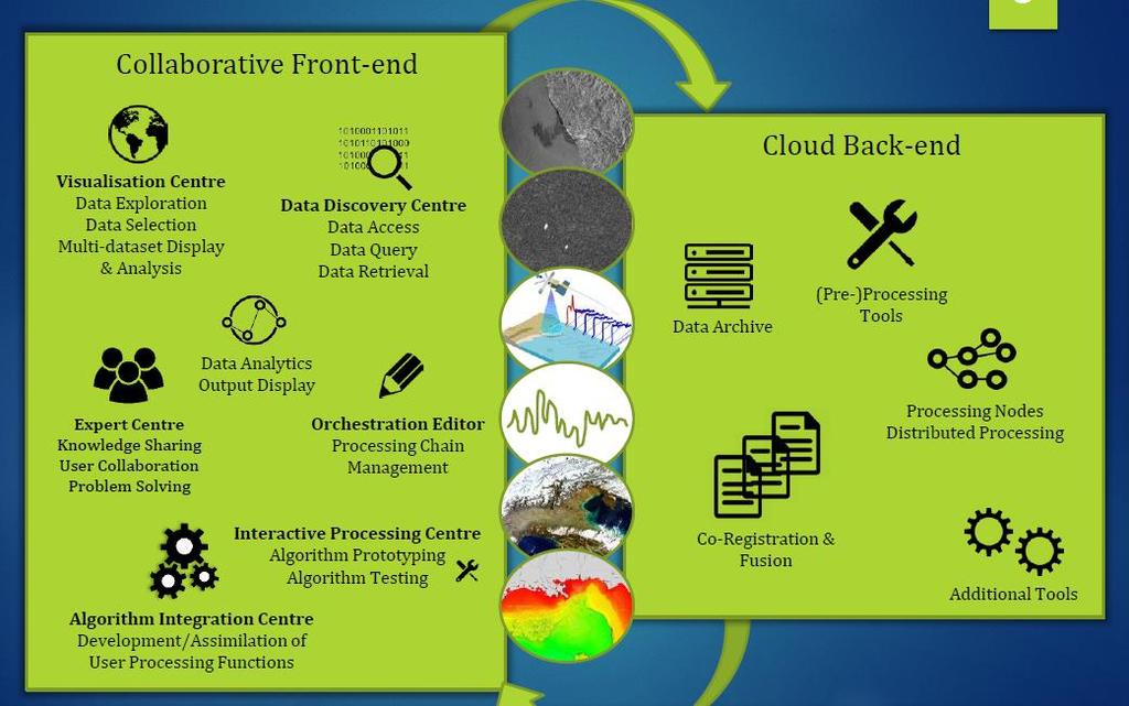
17 Co-ReSyF: Project Overview Easy to use system for coastal waters researchers to process data and share results Data Providers Processing Nodes Co-ReSyF Back End I am configuring what I want to do. It is just connecting boxes!! Co-ReSyF Front End I have a nice map where I can select the area and data to process. No worry to download data!! I received notification that my results are ready. I am looking at the resulting maps and they are great results. I am going to post to the community for feedback!!
18 18
19 Co-ReSyF: Target Users 8 proposals chosen Summer School 12th to 14th of July Who are the users? Phase I (19 months) Consortium partners setting up default services: 1. Bathymetry from SAR (LNEC+IH) 2. Bathymetry, Benthic Classification and Water Quality from Optical (ACRI-HE+IH) 3. Vessel and Oil Spill Detection (UCC+DME) 4. Time-series processing for hyper-temporal optical data (UCC) 5. Ocean and Coastal Altimetry (NOC+UCC) Phase II (13 months) Same users from Phase I Additional collaborators selected from the open call (new services) Applications Synergies services (DME) Phase III (Public access) Anyone with interests in coastal research and related areas
20 NextGEOSS: EO Big Data Access Coordinator: Deimos Engenharia H2020 SPACE 2016 Duration of 3.5 years Centralised Hub for EO Data 10M project 27 partners KO in December 2016


21


 Land")

 and Marine")


22 Data Federation and Uptake Sentinel Collaborative Ground Segments (DLR, NOA) Land (VITO), Atmosphere (WMO, MeteoSwiss, NILU) and Marine (CLS) data sources Citizen Observatories Commercial Providers Federation of additional data sources Dedicated CKAN-based harvesting tools for major data providers relying on OpenSearch and OGC standards Will incorporate previous initiatives on data harmonisation
23 Thank you Nuno Grosso EO Applications and Ground Segment Division
The NextGEOSS Project
 NextGEOSS GEOSS Interoperability workshop 28 August 2017 The NextGEOSS Project Marie-Francoise Voidrot, Bart De Lathouwer Open Geospatial Consortium Europe Nuno Catarino DEIMOS Head of Data Systems NextGEOSS
Next GEOSS der neue europäische GEOSS Hub
 DLR.de Folie 1 27.10.2016, Oberpfaffenhofen Next GEOSS der neue europäische GEOSS Hub J. Meyer-Arnek, A. Müller, G. Schreier DLR.de Folie 2 NextGEOSS-Konsortium Kick-Off: 16-18 JAN 2017 Project duration:
C3S Data Portal: Setting the scene
 C3S Data Portal: Setting the scene Baudouin Raoult Baudouin.raoult@ecmwf.int Funded by the European Union Implemented by Evaluation & QC function from European commission e.g.,fp7 Space call Selected set
Overview of the GMES Space Component & DMC as a GMES Contributing Mission
 Overview of the GMES Space Component & DMC as a GMES Contributing Mission Eleni Paliouras GMES Space Office, Directorate of Earth Observation, ESA DMC Consortium Meeting, London 16/02/2011 ESA UNCLASSIFIED
THE ENVIRONMENTAL OBSERVATION WEB AND ITS SERVICE APPLICATIONS WITHIN THE FUTURE INTERNET Project introduction and technical foundations (I)
") ENVIROfying the Future Internet THE ENVIRONMENTAL OBSERVATION WEB AND ITS SERVICE APPLICATIONS WITHIN THE FUTURE INTERNET Project introduction and technical foundations (I) INSPIRE Conference Firenze,
ENVIROfying the Future Internet THE ENVIRONMENTAL OBSERVATION WEB AND ITS SERVICE APPLICATIONS WITHIN THE FUTURE INTERNET Project introduction and technical foundations (I) INSPIRE Conference Firenze,
Greece s Collaborative Ground Segment Initiatives
 Greece s Collaborative Ground Segment Initiatives Dr Haris KONTOES National Observatory of Athens SENTINEL COLLABORATIVE GS WORKSHOP 2015, 28 May 2015 Matera Collaborative GS workshop 2015 27 28 May 2015
Monitoring the Environment for Climate Change: The case of GMES
 Monitoring the Environment for Climate Change: The case of GMES Presentation at 2008 IISL ECSL Symposium Legal Implications of Space Applications for Climate Change: Principles and Rules Dr. jur.gisela
GMES Status November 2004
 GMES Status November 2004 Peter BREGER DG RTD/H5 «Space: research activities, GMES» GMES GMES: a joint EC-ESA initiative The objective is to establish by 2008 a European capacity for global as well as
INSPIRE overview and possible applications for IED and E-PRTR e- Reporting Alexander Kotsev
 INSPIRE overview and possible applications for IED and E-PRTR e- Reporting Alexander Kotsev www.jrc.ec.europa.eu Serving society Stimulating innovation Supporting legislation The European data puzzle 24
Earth Observation, Climate and Space for Smarter Government
 Earth Observation, Climate and Space for Smarter Government Beth Greenaway, Head of Earth Observation 30 March 2015 http://www.bis.gov.uk/ukspaceagency Overview UK Space Agency EO Importance and priorities
Copernicus Data and Information Access Services(DIAS)
") Data and Information Access Services(DIAS) DG GROW EU EU EU www.copernicus.eu COPERNICUS IN BRIEF is a flagship programme of the European Union: Monitors the Earth, its environment and ecosystems Prepares
Data and Information Access Services(DIAS) DG GROW EU EU EU www.copernicus.eu COPERNICUS IN BRIEF is a flagship programme of the European Union: Monitors the Earth, its environment and ecosystems Prepares
Italy - Information Day: 2012 FP7 Space WP and 5th Call. Peter Breger Space Research and Development Unit
 Italy - Information Day: 2012 FP7 Space WP and 5th Call Peter Breger Space Research and Development Unit Content Overview General features Activity 9.1 Space based applications and GMES Activity 9.2 Strengthening
The Copernicus Sentinel-3 Mission: Getting Ready for Operations
 The Copernicus Sentinel-3 Mission: Getting Ready for Operations Susanne Mecklenburg ESA Sentinel-3 Mission Manager Sentinel-3 ESA development & operations teams Sentinel-3A Status S-3A Satellite on stand
EO Monitoring Solutions
 EO Monitoring Solutions Florin SERBAN, Managing Director TERRASIGNA GEO-CRADLE Regional Workshop in Romania May 9 th 2017, Bucharest Copyright TERRASIGNA 2017 Content Monitoring services based on satellite
Copernicus Space Component. Technical Collaborative Arrangement. between ESA. and. Enterprise Estonia
 Copernicus Space Component Technical Collaborative Arrangement between ESA and Enterprise Estonia 2 Table of Contents 1 INTRODUCTION... 4 1.1 Purpose and objectives... 4 1.2 Scope... 5 1.3 References...
The EUCISE2020 project
 The EUCISE2020 project (EUropean test bed for the maritime Common Information Sharing Environment in the 2020 perspective) P. Sacco, 16/01/2018 CISE Roadmap Cross Sectorial interoperability for better
The Copernicus Data and Exploitation Platform Deutschland (CODE-DE)
") DLR.de Slide 1 The Copernicus Data and Exploitation Platform Deutschland (CODE-DE) Jörn Hoffmann DLR Space Administration EO4Baltic Workshop Helsinki, Finland March 29, 2017 DLR.de Slide 2 DLR a dual capacity
DLR.de Slide 1 The Copernicus Data and Exploitation Platform Deutschland (CODE-DE) Jörn Hoffmann DLR Space Administration EO4Baltic Workshop Helsinki, Finland March 29, 2017 DLR.de Slide 2 DLR a dual capacity
Towards a pan-european infrastructure for marine and ocean data management + Importance of standards
 Towards a pan-european infrastructure for marine and ocean data management + Importance of standards By Dick M.A. Schaap Technical Coordinator SeaDataNet & Coordinator EMODnet Bathymetry Hydrography Day,
European Marine Data Exchange
 European Marine Data Exchange By Dick M.A. Schaap MARIS (NL) EU SeaDataNet Technical Coordinator EU EMODnet Ingestion Coordinator Noordzeedagen 2018 - October 2018 Acquisition of ocean and marine data
Co-ReSyF Hands-on sessions
 This project has received funding from the European Union s Horizon 2020 Research and Innovation Programme under grant agreement no 687289 Co-ReSyF Hands-on sessions Coastal Waters Research Synergy Framework
GMES The EU Earth Observation Programme
 GMES The EU Earth Observation Programme Ondřej Mirovský Czech Space Office, Prvního Pluku 17, Prague 8, 186 00, Czech Republic mirovsky@czechspace.cz Abstract. The paper describes evolution, recent development
JOURNÉE CNES INDUSTRIE 2018 «SATELLITES ET APPLICATIONS» 26 JUIN Pierre LEONARD: marketing & communication
 JOURNÉE CNES INDUSTRIE 2018 «SATELLITES ET APPLICATIONS» 26 JUIN 2018 Pierre LEONARD: marketing & communication Knowledge-based companies Pilar 1 Space Pilar 2 Geo-information Pilar 3 Engineering Holding
Sentinel-1A Data Dissemination and Users Data Uptake. Jolyon Martin (ESA) Betlem Rosich Tell (ESA) Michael Foumelis (RSAC c/o ESA)
 Betlem Rosich Tell (ESA) Michael Foumelis (RSAC c/o ESA)") Sentinel-1A Data Dissemination and Users Data Uptake Jolyon Martin (ESA) Betlem Rosich Tell (ESA) Michael Foumelis (RSAC c/o ESA) Copernicus Space Component: Data Access Overview The Copernicus Space Component
Sentinel-1A Data Dissemination and Users Data Uptake Jolyon Martin (ESA) Betlem Rosich Tell (ESA) Michael Foumelis (RSAC c/o ESA) Copernicus Space Component: Data Access Overview The Copernicus Space Component
EMODnet Bathymetry. By Dick M.A. Schaap Coordinator. 20 th April 2016, EGU 2016, Vienna - Austria
 EMODnet Bathymetry By Dick M.A. Schaap Coordinator 20 th April 2016, EGU 2016, Vienna - Austria EMODNet Bathymetry Ongoing in 3 consecutive projects since 2009 with expanding consortium (at present >30
GSCB-Workshop on Ground Segment Evolution Strategy
 GSCB-Workshop on Ground Segment Evolution Strategy N. Hanowski, EOP-G, Ground Segment and Operations Department, nicolaus.hanowski@esa.int 24 September 2015 ESA UNCLASSIFIED For Official Use - Slide 1
Copernicus Climate Change Service
 Climate Data Store, Toolbox Geneva, 6-8 th of December 2016 Cedric Bergeron cedric.bergeron@ecmwf.int Angel Lopez Alos Baudouin Raoult angel.lopez@ecmwf.int baudouin.raoult@ecmwf.int Budget of 4.3 Bn for
Towards a Federated Collaborative Platform - From OGC Testbed13 to the Future
 Towards a Federated Collaborative Platform - From OGC Testbed13 to the Future Cristiano Lopes WIGSS#44 Beijing 27 Sep 2017 ESA UNCLASSIFIED - For Official Use OGC Testbed 13 - Recall Part of the Open Geospatial
*Open source (GIT) *Server : data storage and indexing, web server. *Client : web and stand alone (under development)
 *Server : data storage and indexing, web server. *Client : web and stand alone (under development)") EO Open Science 2.0, ESRIN, Oct. 13 2015 *The main objective of the project is to allow oceanographers experts to discover the existence and then to handle jointly, in a convenient, flexible and intuitive
EO Open Science 2.0, ESRIN, Oct. 13 2015 *The main objective of the project is to allow oceanographers experts to discover the existence and then to handle jointly, in a convenient, flexible and intuitive
EU SPACE POLICY AND PROGRAMMES AUGUSTO GONZÁLEZ
 EU SPACE POLICY AND PROGRAMMES AUGUSTO GONZÁLEZ A HIGHLY DEVELOPED SPACE INDUSTRIAL BASE AND RESEARCH COMMUNITY The European space industry sustains around 38,000 direct jobs Europe is successful in the
Il pacchetto europeo sull accesso ai dati
 Il pacchetto europeo sull accesso ai dati Elisabetta Nori - Martedì, 16 ottobre 2018 GeoInformation market trends We are in a growing market that is changing faster than usual Global Satellite-Based EO
SeaDataNet, Pan-European infrastructure for marine and ocean data management + EMODNET Bathymetry
 SeaDataNet, Pan-European infrastructure for marine and ocean data management + EMODNET Bathymetry By Dick M.A. Schaap Technical Coordinator SeaDataNet & Coordinator EMODNet Bathymetry Limassol Cyprus,
Towards a Canadian Integrated Ocean Observing System
 Towards a Canadian Integrated Ocean Observing System CMOS Luncheon (Ottawa) February 28, 2018 Andrew Stewart Fisheries and Oceans Canada The Ocean is Valuable Ocean Economy: Ocean-based industries Natural
GMES Global Monitoring for Environment and Security
 GMES Global Monitoring for Environment and Security European Commission, GMES Bureau Pleiades Days, 17-18 January 2012, Toulouse, France From Baveno to GMES Initial Operations 15 years of continuous effort
Oceanic Observatory for the Iberian Shelf
 Oceanic Observatory for the Iberian Shelf B.Vila Barcelona, 26th September 2016 Objectives: The Project Improve the oceanic observation at the North Western Iberian coast (meteorological, oceanographical
HMA Standardisation Status
 HMA Standardisation Status GSCB Meeting, 18-19 June 2009, Frascati P.G. Marchetti, ESA Y. Coene, SPACEBEL GSCB Meeting, 18 June 2009 Slide 1 Overview Context and Objectives Evolution of specifications
INSPIRE & Environment Data in the EU
 INSPIRE & Environment Data in the EU Andrea Perego Research Data infrastructures for Environmental related Societal Challenges Workshop @ pre-rda P6 Workshops, Paris 22 September 2015 INSPIRE in a nutshell
Heterogeneous Missions Accessibility: Interoperability for Earth Observation
 Heterogeneous Missions Accessibility: Interoperability for Earth Observation Pier Giorgio Marchetti - European Space Agency pier.giorgio.marchetti@esa.int Slide 1 EO missions Earth Explorer Global Challenges
Sodankylä National Satellite Data Centre. Jyri Heilimo Head of Satellite based services R&D
 Sodankylä National Satellite Data Centre Jyri Heilimo Head of Satellite based services R&D Sodankylä National Satellite Data Centre National satellite data center providing satellite data reception and
Enabling BigData Workflows in Earth Observation Science
 Enabling BigData Workflows in Earth Observation Science A RESEARCH NETWORKING PERSPECTIVE Jakob Tendel Maria Minaricova DFN GÉANT Outline Research and Education Networking National Research and Education
Global Monitoring for Environment and Security (GMES) State-of-play. Espen Volden European Commission GMES Bureau
 State-of-play. Espen Volden European Commission GMES Bureau") Global Monitoring for Environment and Security (GMES) State-of-play Espen Volden European Commission GMES Bureau GMES in a nutshell Earth observation is a powerful advanced technology which through space
Global Monitoring for Environment and Security (GMES) State-of-play Espen Volden European Commission GMES Bureau GMES in a nutshell Earth observation is a powerful advanced technology which through space
BEYOND Ground Segment Facility The Hellenic Sentinel Data Hub (Mirror Site)
") BEYOND Ground Segment Facility The Hellenic Sentinel Data Hub (Mirror Site) www.beyond-eocenter.eu The final BEYOND workshop, 17 May 2016 FP7-Regpot-2012-13-1 The 1st Collaborative Ground Segment (Mirror
BEYOND Ground Segment Facility The Hellenic Sentinel Data Hub (Mirror Site) www.beyond-eocenter.eu The final BEYOND workshop, 17 May 2016 FP7-Regpot-2012-13-1 The 1st Collaborative Ground Segment (Mirror
Desarrollo de una herramienta de visualización de datos oceanográficos: Modelos y Observaciones
 Desarrollo de una herramienta de visualización de datos oceanográficos: Modelos y Observaciones J. Fernandez, J. Lopez, I. Carlos, F. Jerez, F. Hermosilla, M. Espino SIMO, LIM-UPC, CIIRC FIELD_AC 7 th
Introduction to INSPIRE. Network Services
 Introduction to INSPIRE. Network Services European Commission Joint Research Centre Institute for Environment and Sustainability Digital Earth and Reference Data Unit www.jrc.ec.europa.eu Serving society
Global Monitoring for Environment and Security
 Global Monitoring for Environment and Security Final Report for the GMES Initial Period (2001-2003) Version 3.5 1 The GMES initiative was launched in May 1998 in Baveno and adopted by the ESA and EU Councils
ESA EO Programmes for CM16. EOEP-5 Block 4. Bilateral meeting with AT Delegation and Industry Vienna, 24/05/2016. ESA UNCLASSIFIED - For Official Use
 ESA EO Programmes for CM16 EOEP-5 Block 4 Bilateral meeting with AT Delegation and Industry Vienna, 24/05/2016 EOEP-5 Block-5: EO Science for Society EO Science for Society will foster scientific excellence,
CISE. an INFORMATION SHARING TOOL to support INTEGRATED MARITIME SURVEILLANCE. European Maritime Day Göteborg, May 22 nd 2012
 CISE an INFORMATION SHARING TOOL to support INTEGRATED MARITIME SURVEILLANCE European Maritime Day Göteborg, May 22 nd 2012 Maritime Surveillance: What? WHAT S GOING ON AT SEA? AWARENESS Legitimate Activities
INTAROS Integrated Arctic Observation System
 INTAROS Integrated Arctic Observation System A project funded by EC - H2020-BG-09-2016 Coordinator: Stein Sandven Nansen Environmental and Remote Sensing Center, Norway Overall objective: to develop an
Service Definition Document
 This project has received funding from the European Union s Horizon 2020 research and innovation programme under grant agreement No 687289 Coastal Waters Research Synergy Framework Service Definition Document
Driftsonde System Overview
 Driftsonde System Overview Zero-pressure Balloon Gondola (24 sonde capacity) 6 hours between drops Terry Hock, Hal Cole, Charlie Martin National Center for Atmospheric Research Earth Observing Lab December
AGENCY: National Weather Service, National Oceanic and Atmospheric Administration, U.S.
 This document is scheduled to be published in the Federal Register on 04/20/2018 and available online at https://federalregister.gov/d/2018-08336, and on FDsys.gov Billing Code 3510-KE-P DEPARTMENT OF
Sub-national dimensions of INSPIRE
 www.eurogeographics.org CONNECTING YOU TO THE Sub-national dimensions of INSPIRE SDIs in the evolving EU society Dave Lovell, Secretary General and Executive Director 24 June 2013 Copyright 2013 EuroGeographics
Interoperability in Science Data: Stories from the Trenches
 Interoperability in Science Data: Stories from the Trenches Karen Stocks University of California San Diego Open Data for Open Science Data Interoperability Microsoft escience Workshop 2012 Interoperability
Maritime Security Panel Canadian Maritime Security Impact of Big Data
 Maritime Security Panel Canadian Maritime Security Impact of Big Data Maritime security Canada In Halifax, easy to understand Canada s connection and dependence on free access to the world s oceans In
DEVELOPMENT OF A TOOL FOR OFFSHORE WIND RESOURCE ASSESSMENT FOR WIND INDUSTRY
 DEVELOPMENT OF A TOOL FOR OFFSHORE WIND RESOURCE ASSESSMENT FOR WIND INDUSTRY Alberto Rabaneda Dr. Matthew Stickland University of Strathclyde Mechanical and Aerospace Engineering Department Wind resource
Data Warehouse Phase 2 CORE Datasets Status 15 th December 2018
 Data Warehouse Phase 2 CORE Datasets Status 15 th December 2018 The document presents the status of the open CORE datasets, for which data provision is on-going. Once closed, content of the datasets can
The EOC Geoservice: Standardized Access to Earth Observation Data Sets and Value Added Products ABSTRACT
 The EOC Geoservice: Standardized Access to Earth Observation Data Sets and Value Added Products K. Dengler, T. Heinen, A. Huber, K. Molch, E. Mikusch German Aerospace Center (DLR) German Remote Sensing
SAP HANA Spatial Location-based business platform
 SAP HANA Spatial Location-based business platform Thomas Hammer, HANA Spatial Development April 19, 2018 SAP HANA Architecture Application development All Devices SAP, ISV and Custom Applications SAP HANA
SeaDataNet, Pan-European infrastructure for marine and ocean data management + EMODNET
 SeaDataNet, Pan-European infrastructure for marine and ocean data management + EMODNET By Dick M.A. Schaap Technical Coordinator SeaDataNet & Coordinator EMODNet Bathymetry San Francisco USA, 13 December
Towards a pan-european infrastructure for marine and ocean data management + Importance of standards
 Towards a pan-european infrastructure for marine and ocean data management + Importance of standards By Dick M.A. Schaap MARIS Technical Coordinator SeaDataNet & ODIP Coordinator EMODnet Bathymetry Münster
Greece s Collaborative Ground Segment Initiatives
 Greece s Collaborative Ground Segment Initiatives Dr Haris KONTOES, Prof Kanaris Tsinganos National Observatory of Athens Dr Xenofon Tsilimparis, GRNET (GEANT) The oldest Greek/SE European Research Institution:
Alexi Glover & Juha-Pekka Luntama SSA Programme Space Weather Segment, OPS-L ESA/ESAC, Madrid, Spain
 Alexi Glover & Juha-Pekka Luntama SSA Programme Space Weather Segment, OPS-L ESA/ESAC, Madrid, Spain Presentation Outline 1. SSA Programme short introduction 2. SWE Service Domains 3. Precursor Services
National Satellite Data Centre and Finnish Collaborative GS. Jyri Heilimo Finnish Meteorological Institute Finland Collaborative Ground Stations NCP
 National Satellite Data Centre and Finnish Collaborative GS Jyri Heilimo Finnish Meteorological Institute Finland Collaborative Ground Stations NCP National Satellite Data Center 6.9.2016 National satellite
PROTECTED AREAS from SPACE. Viewing products with data quality and geospatial user feedback
 PROTECTED AREAS from SPACE. Viewing products with data quality and geospatial user feedback Joan Masó ECOPotential description ECOPOTENTIAL is a large European funded H2020 project that focuses on serving
International Oceanographic Data and Information Exchange - Ocean Data Portal (IODE ODP)
") International Oceanographic Data and Information Exchange - Ocean Data Portal (IODE ODP) Enabling science through seamless and open access to marine data Credits This presentation was developed by: Mr.
International Oceanographic Data and Information Exchange - Ocean Data Portal (IODE ODP) Enabling science through seamless and open access to marine data Credits This presentation was developed by: Mr.
a ESRIN Via Galileo Galilei - Casella Postale Frascati - Italy Tel. (39) Fax (39)
 Fax (39)") D O C U M E N T document title/ titre du document UIDELINES FOR THE SUBMISSION OF EGISTRATIONS prepared by/préparé par ESA EO R&D Section reference/réference issue/édition 5 revision/révision 1 date of
D O C U M E N T document title/ titre du document UIDELINES FOR THE SUBMISSION OF EGISTRATIONS prepared by/préparé par ESA EO R&D Section reference/réference issue/édition 5 revision/révision 1 date of
PART I: Collecting data from National Earth Observatory
 Investigation: Sea Surface Temperature We ve seen how temperature varies with depth, but how does it vary with latitude and season? In this investigation, you are going to explore sea surface temperatures
Automotive and Aerospace Synergies
 Corporate Technical Office Automotive and Aerospace Synergies Potential for common activities Denis Chapuis, EADS Corporate Technical Office, Electronics denis.chapuis@eads.net Seite 1 Presentation title
EVOlution of EO Online Data Access Services (EVO-ODAS) ESA GSTP-6 Project by DLR, EOX and GeoSolutions (2015/ /04)
 ESA GSTP-6 Project by DLR, EOX and GeoSolutions (2015/ /04)") EVOlution of EO Online Data Access Services (EVO-ODAS) ESA GSTP-6 Project by DLR, EOX and GeoSolutions (2015/10 2017/04) 2016 Conference on Big Data from Space - BiDS 16, Tenerife, 15 th -17 th March Evolution
EVOlution of EO Online Data Access Services (EVO-ODAS) ESA GSTP-6 Project by DLR, EOX and GeoSolutions (2015/10 2017/04) 2016 Conference on Big Data from Space - BiDS 16, Tenerife, 15 th -17 th March Evolution
Global Forest Observations Initiative (GFOI) Overview. Frank Martin Seifert, ESA SDCG-8 Commercial Providers Day, Bonn, 23 September 2015
 Overview. Frank Martin Seifert, ESA SDCG-8 Commercial Providers Day, Bonn, 23 September 2015") Global Forest Observations Initiative (GFOI) Overview Frank Martin Seifert, ESA SDCG-8 Commercial Providers Day, Bonn, 23 September 2015 Global Forest Observation Initiative coordinating observations CEOS
Global Forest Observations Initiative (GFOI) Overview Frank Martin Seifert, ESA SDCG-8 Commercial Providers Day, Bonn, 23 September 2015 Global Forest Observation Initiative coordinating observations CEOS
Erdbeobachtung für die Maritime Sicherheit
 Erdbeobachtung für die Maritime Sicherheit Nationales Forum für Fernerkundung und Copernicus 2015 "Copernicus erfolgreich nutzen" Egbert Schwarz German Remote Sensing Data Center Maritime Security Lab
Future Core Ground Segment Scenarios
 Future Core Ground Segment Scenarios Pascal Gilles EOP-G Ground Segment Coordination Body Workshop 2015 ESRIN, 24 September2015 Ground Segment Coordination Body Workshop 2015 ESRIN 24 September2015 Pag.
Ocean Colour Vicarious Calibration Community requirements for future infrastructures
 Ocean Colour Vicarious Calibration Community requirements for future infrastructures IOCS 2017 - Breakout Workshop#3 IOCS 2017 ocean colour vicarious calibration 1 Part II: Discussion on community requirements
The NOA Ground Segment Facility The Hellenic Sentinel Data Hub (Mirror Site)
") NOA GS & The Hellenic Sentinel Data Hub The NOA Ground Segment Facility The Hellenic Sentinel Data Hub (Mirror Site) Dr Haris KONTOES, prof. Kanaris Tsinganos National Observatory of Athens Dr Xenofon
NOA GS & The Hellenic Sentinel Data Hub The NOA Ground Segment Facility The Hellenic Sentinel Data Hub (Mirror Site) Dr Haris KONTOES, prof. Kanaris Tsinganos National Observatory of Athens Dr Xenofon
SES 123 Global and Regional Energy Lab Worksheet
 SES 123 Global and Regional Energy Lab Worksheet Introduction An important aspect to understand about our planet is global temperatures, including spatial variations, such as between oceans and continents
The CEDA Archive: Data, Services and Infrastructure
 The CEDA Archive: Data, Services and Infrastructure Kevin Marsh Centre for Environmental Data Archival (CEDA) www.ceda.ac.uk with thanks to V. Bennett, P. Kershaw, S. Donegan and the rest of the CEDA Team
Bringing Disaster Management Information to the Web: Efforts at the German Remote Sensing Data Center
 German Aerospace Center (DLR) Bringing Disaster Management Information to the Web: Efforts at the German Remote Sensing Data Center Stefan Plattner DLR-DFD www.dlr.de Chart 2 > Bringing Disaster Management
Emergency Response through Collaborative Crisis Management
 Emergency Response through Collaborative Crisis Management Bojan Cestnik Temida d.o.o. Ljubljana Slovenia Artur Rocha INESC Porto Porto Portugal Martin Endig IFF Magdeburg Germany 30.3.2005 1 Contents
Simplify EO data exploitation for information-based services
 RESEARch And SERvicE SuppORt Simplify EO data exploitation for information-based services www.esa.int European Space Agency As part of ESA s Earth Observation Ground Segment Department, RSS has the mission
OPERATIONAL SHIP DETECTION & RAPID URBAN MAPPING : EXPLORING DIVERSE METHODOLOGICAL APPROACHES IN OBJECT RECOGNTION AND SATELLITE IMAGE CLASSIFICATION
 Journées ORFEO Méthodo 10-11 Janvier 2008 OPERATIONAL SHIP DETECTION & RAPID URBAN MAPPING : EXPLORING DIVERSE METHODOLOGICAL APPROACHES IN OBJECT RECOGNTION AND SATELLITE IMAGE CLASSIFICATION Michel Petit,
Earth Observation data & users How will EO data be used in 2025?
 Earth Observation data & users How will EO data be used in 2025? ESA UNCLASSIFIED For Official Use Facilitating use of Earth Observation data Easy access & use of EO data è creation of knowledge and business
SAFER the GIGAS Effect
 SAFER the GIGAS Effect How INSPIRE, GMES and GEOSS are influencing EC projects Arnaud Cauchy 23/06/2010 Agenda GIGAS Project Summary SAFER Project Summary SAFER Original Approach GIGAS Influences SAFER
Marine Information Objects (MIOs) and ECDIS: Concept and Practice
 and ECDIS: Concept and Practice") Proceedings: U.S. Hydrographic Conference, 24-27 March 2003, Biloxi, MS Marine Information Objects (MIOs) and ECDIS: Concept and Practice Dr. Lee Alexander 1 Center for Coastal and Ocean Mapping Joint
Proceedings: U.S. Hydrographic Conference, 24-27 March 2003, Biloxi, MS Marine Information Objects (MIOs) and ECDIS: Concept and Practice Dr. Lee Alexander 1 Center for Coastal and Ocean Mapping Joint
The GIGAS Methodology
 The GIGAS Methodology Pier Giorgio Marchetti European Space Agency Earth Observation Programme Ground Segment Department pier.giorgio.marchetti@esa.int GIGAS Objectives GIGAS has the goal to promote the
A SMART PORT CITY IN THE INTERNET OF EVERYTHING (IOE) ERA VERNON THAVER, CTO, CISCO SYSTEMS SOUTH AFRICA
 ERA VERNON THAVER, CTO, CISCO SYSTEMS SOUTH AFRICA") A SMART PORT CITY IN THE INTERNET OF EVERYTHING (IOE) ERA VERNON THAVER, CTO, CISCO SYSTEMS SOUTH AFRICA Who is Cisco? Convergence of Mobile, Social, Cloud, and Data Is Driving Digital Disruption Digital
A SMART PORT CITY IN THE INTERNET OF EVERYTHING (IOE) ERA VERNON THAVER, CTO, CISCO SYSTEMS SOUTH AFRICA Who is Cisco? Convergence of Mobile, Social, Cloud, and Data Is Driving Digital Disruption Digital
Intelligent Urban Mobility Management System of Thessaloniki A common effort of the city s stakeholders
 Intelligent Urban Mobility Management System of Thessaloniki A common effort of the city s stakeholders Evangelos Mitsakis, CERTH-HIT September 10, 2012 Project data Funding 50% European Economic Area
The European Commission s science and knowledge service Joint Research Centre
 Future prospects for satellite environmental information in support of Development Aid September 11-12, ESRIN Frascati The European Commission s science and knowledge service Joint Research Centre Antoine
Commercial Partnerships for Exploration: Making Small Lunar Missions Viable
 Commercial Partnerships for Exploration: Making Small Lunar Missions Viable S.Jason 1, C. Saunders 1, J. Friend 1, M.Cosby 2, J.Carpenter 3, B.Hufenbach 3 V.La Regina 3, M.Sweeting 4 1. Surrey Satellite
Oracle Buys Corente. Extends Oracle s Virtualization Capabilities with Leading Software-Defined Networking Technology to Deliver Cloud Services
 Oracle Buys Corente Extends Oracle s Virtualization Capabilities with Leading Software-Defined Networking Technology to Deliver Cloud Services March 5, 2014 Oracle is currently reviewing the existing Corente
JAXA's Earth Observation Data and Information System Copernicus Big Data Workshop March 13-14, 2014 European Commission, Brussels
 JAXA's Earth Observation Data and Information System Copernicus Big Data Workshop March 13-14, 2014 European Commission, Brussels Osamu Ochiai Japan Aerospace Exploration Agency (JAXA) JAXA EO Satellite
SPACE for SDGs a Global Partnership
 SPACE for SDGs a Global Partnership for the Coordination of the Development, Operation and Utilization of Space related Infrastructure, Data, Information and Services in support of the 2030 Development
EU LEIT-ICT program and SE position on FP9
 EU LEIT-ICT program 2018-2020 and SE position on FP9 Johan Harvard, Deputy Director, Ministry of Enterprise and Innovation Ministry of Enterprise and Innovation 1 Horizon 2020 A European Research & Innovation
Automated feature extraction by combining polarimetric SAR and object-based image analysis for monitoring of natural resource exploitation
 DLR.de Chart 1 Automated feature extraction by combining polarimetric SAR and object-based image analysis for monitoring of natural resource exploitation Simon Plank, Alexander Mager, Elisabeth Schoepfer
Introduction of SeaDataNet and EMODNET Working towards a harmonised data infrastructure for marine data. Peter Thijsse MARIS
 Introduction of SeaDataNet and EMODNET Working towards a harmonised data infrastructure for marine data Peter Thijsse MARIS CLIPC & IS-ENES 2 workshop, KNMI, November 2014 Outline 1. Introduction to marine
SES 123 Global and Regional Energy Lab Procedures
 SES 123 Global and Regional Energy Lab Procedures Introduction An important aspect to understand about our planet is global temperatures, including spatial variations, such as between oceans and continents
Role and relevance of space applications in the wider economy 19 April 2012
 Role and relevance of space applications in the wider economy 19 April 2012 Iain Gray Chief Executive Technology Strategy Board Agenda Introduction to the Technology Strategy Board Our role in Space Space
(Towards) A metadata model for atmospheric data resources
 A metadata model for atmospheric data resources") (Towards) A metadata model for atmospheric data resources Anne De Rudder and Jean-Christopher Lambert Belgian Institute for Space Aeronomy (IASB-BIRA), Brussels The context EU FP7 Ground-based atmospheric
(Towards) A metadata model for atmospheric data resources Anne De Rudder and Jean-Christopher Lambert Belgian Institute for Space Aeronomy (IASB-BIRA), Brussels The context EU FP7 Ground-based atmospheric
What Is a Distributed Simulation (i.e., A Federation)?
?") M&S VV&A RG Core Document: VV&A of Federations What Is a Distributed Simulation (i.e., A Federation)? 1/31/2011 A distributed simulation is defined as a disparate set of models and/or simulations operating
M&S VV&A RG Core Document: VV&A of Federations What Is a Distributed Simulation (i.e., A Federation)? 1/31/2011 A distributed simulation is defined as a disparate set of models and/or simulations operating
CASE STUDY. Case Study: Thuraya Orion IP. Products: Thuraya Orion IP Thuraya SF2500. Location: Caspian Sea, Kazakhstan
 Case Study: Thuraya Orion IP Products: Thuraya Orion IP Thuraya SF2500 Location: Caspian Sea, Kazakhstan Thuraya is helping to protect the unique and fragile ecosystem of the largest salt lake on Earth
Big Data in Earth Observation
 Digital Transformation Monitor Big Data in Earth Observation July 2017 Internal Market, Industry, Entrepreneurship and SMEs Big Data in Earth Observation lexaarts/shutterstock.com Thanks to technological
INSIDE THE PROTOTYPE BODENTYPE DATA CENTER: OPENSOURCE MONITORING OF OPENSOURCE HARDWARE
 INSIDE THE PROTOTYPE BODENTYPE DATA CENTER: OPENSOURCE MONITORING OF OPENSOURCE HARDWARE Dr Jon Summers Scientific Leader in Data Centers, RISE Adjunct Professor of Fluid Mechanics, Lulea University of