MICA High Water Mark Mapping Project What WE Learned Mission Assignment 4222DR-OK-COE-SWD-01/02
|
|
|
- Godfrey Jayson Matthews
- 5 years ago
- Views:
Transcription


1 MICA High Water Mark Mapping Project What WE Learned Mission Assignment 4222DR-OK-COE-SWD-01/02

2 Disaster DR-4222 Oklahoma Severe Storms, Tornadoes, Straight-line Winds, and Flooding Major Disaster Declaration declared on May 26, 2015 Incident period May 5, 2015 to June 4, 2015 Extended to June 19, 2015 to include TS Bill 2
3 Disaster DR-4222 May 6-25,


4 DR-4222 Cache, OK 4
5 Disaster DR-4222 May 2-31,


6 DR-4222 Norman & Tecumseh, OK 6


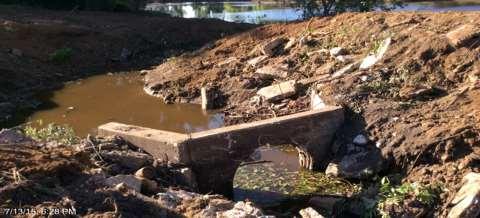
7 DR-4222 Muskogee, OK dd 7

8 Disaster DR-4222 Rain Fall OAEPs 8
9 NOAA Rainfall Amounts / Rainfall Frequency 9


10 DR-4222 Davis, OK 10


11 DR-4222 Marshall Co. 11


12 Christmas Flooding Event- Cherokee Co. 12


13 Christmas Flooding Event- Cherokee Co. 13

14 Flood Insurance Rate Map Availability and Currency 14
 Collect location (lat/long) and elevation of mark (X,Y, and Z coordinates) Supply photo documentation and field notes Provide real-time HWM collection website for reporting and data")
15 High Water Marks & Event Determination MA 4222DR-OK-COE-SWD-01/02 Statement of Work includes tasks to: Locate and identify high water marks for recording (water stains, debris lines, and other recordable items) Collect location (lat/long) and elevation of mark (X,Y, and Z coordinates) Supply photo documentation and field notes Provide real-time HWM collection website for reporting and data access to Federal and State partners High water mark Geo-database deliverable Review gage analysis and recent storm radar information to determine amount of rainfall Perform statistical analysis to determine recent event frequency equivalence 15
16 Short Term Outcomes Aides/Informs FEMA s Public Assistance and Floodplain Management and Insurance team efforts Allows review of current available flood hazard information against recent event(s) Assists State of Oklahoma in assessing current flood risk Identifies low water crossings Vulnerable populations identified Provides community understanding of recent flood events 16
17 Long Term Outcomes Assists State of Oklahoma in assessing current flood risk and determining mitigation opportunities Provides information for refinement flood risk profile, extent and vulnerability assessment within State Hazard Mitigation Plan Offers data points for future prioritization of flood hazard mapping program investment Identifies mitigation activity opportunities for long term risk reduction Determines event frequencies and recent rainfall amounts Supports Federal and State agency review of available resources and current flood risk understanding Promotes local and public understanding of recent events Supports Regional investment in updated modeling within the Cache/Washita, Little and Deep Fork River basins. 17

18 High Water Marks & Event Determination MA 4222DR-OK-COE-SWD-01/02 18


19 Fully-Digital Data Collection and Rapid Data Transfer OWRB analyzed and determined strategic locations for HWM collection field deployment Mobile computing reduces errors and saves hours of time by eliminating manual data entry. With cellular internet access, mobile computing applications immediately send data from the field to the server for review and analysis. Centralizes data collection from multiple remote teams 19


20 Field Crew Verified the 1% Floodplain Models 20


21 21

22 MICA Portal 22

23 High Water Mark Map Book Index 23

24 High Water Mark Map Book 24
25 High Water Mark Map Book 25

26 High Water Mark Map Book 26

27 High Water Mark Map Book 27

28 High Water Mark Map Book 28

29 OWRB Web Site HWM Project Mapping & Data Information 29
30 HWM FEMA Data Access Non-GIS Information 30

31 OK-2015 High Water Marks- GIS Mapping 31

32 High Water Mark Locations Zoom into Additional Marks 32

33 High Water Marks A Closer Look for Additional Locations 33

34 High Water Marks to Verify Mapping and Models 34

35 High Water Marks Inundation Mapping 35

36 Oklahoma High Water Marks- Watershed Locations 36

37 Oklahoma NFHL Participating Communities 37

38 High Water Marks / Inundation Mapping / Depth Grids West & East Cache Creek 38

39 High Water Marks / Inundation Mapping / Depth Grids - Shawnee 39

40 High Water Marks / Inundation Mapping / Depth Grids Lower Washita 40

41 High Water Marks / Inundation Mapping / Depth Grids Lower Canadian Walnut 41
42 High Water Marks & Event Determination MA 4222DR-OK-COE-SWD-01/02 Lessons Learned HWM data is EXTREMELY perishable Suggest interagency coordination in peace time to allow data collection efforts to commence with event occurrence in the future Begin data collection efforts during FEMA response efforts for best data availability Train crews prior to field activation Have supplies and Equipment ready Scope of Work elements and specificity is critical to success Know your areas of concern, your older mapped areas or no maps Local FPAs and EMs Deploy to your critical areas, notify State of High Water Marks and Target sites 42
43 High Water Mark Mission Readiness The following Informational Components to develop your State High Water Mark Mission are available at Oklahoma Water Resources Board Floodplain Management Section, Beth Wilhelm, EI, CFM Oklahoma Mission Framework Field Crew Practices and Procedures Equipment Selection and Evaluation Surge Funding (prior to Disaster Declaration) Estimator 43

44 Was it The CRIMSON TIDE that inundated OKLAHOMA S Floodplains during DR-4222 HWM Collection will save lives in the future Be Prepared! 44

45 Questions? For further Information Contact S. Beth Wilhelm, EI,CFM Oklahoma Water Resources Board
Planning for Resiliency. June 20, 2017 Richard Tetreault, PE WSP USA Office Lead VT, NH, and ME
 Planning for Resiliency June 20, 2017 Richard Tetreault, PE WSP USA Office Lead VT, NH, and ME 23,000 years ago there would have been more than 8,000 feet of glacier over our heads 2 Provide for the safe
Edward G. Beadenkopf, PE, CFM RAMPP-URS Corporation
 FEMA and Multi-Federal Agency Cooperation to Support Dam Safety and to Develop Tools for States and Local Communities to Create More Resilient Communities Edward G. Beadenkopf, PE, CFM RAMPP-URS Corporation
THINK RESILIENCY 2.0 WITH VIZONOMY
 VIZONOMY // 01 ABOUT US The greatest advances in climate risk awareness will be those that merge, harness, and properly communicate big data sources to drive meaningful action and response. Vizonomy s
Applying Mitigation. to Build Resilient Communities
 Applying Mitigation to Build Resilient Communities The Hazards Around Us Think about the natural hazard that... poses the greatest risk to where you live or work OR has had the greatest impact on you personally
Outreach and Mitigation: A Convenient Partnership in Loss Reduction. Scott Schelling and Carver Struve, CFM
 Outreach and Mitigation: A Convenient Partnership in Loss Reduction Scott Schelling and Carver Struve, CFM Purpose = Program Transformation Goal = Process Integration Risk Identification Community Engagement
Marine Transportation System Resilience: A Federal Agency Perspective
 Marine Transportation System Resilience: A Federal Agency Perspective Katherine Touzinsky, USACE-ERDC TRB-CMTS Biennial Conference, June 21-23 rd, 2016 Resilience Integrated Action Team: Mission and Objectives
Ada L. Benavides, Deputy Chief South Pacific Division Regional Integration Team. May 5, US Army Corps of Engineers BUILDING STRONG
 Building Strong Collaborative Relationships for a Sustainable Water Resources Future The Federal Support Toolbox for Integrated Water Resources Management Ada L. Benavides, Deputy Chief South Pacific Division
Lidar Talking Points Status of lidar collection in Pennsylvania Estimated cost and timeline
 Lidar Talking Points Pennsylvania has an immediate need for new lidar (topographic) data coverage. Some uses of the data are enumerated later in this document. USGS has calculated an average return on
North Atlantic Coast Comprehensive Study
 North Atlantic Coast Comprehensive Study U.S. Army Corps of Engineers Coastal Storm Damage Reduction Planning Center of Expertise 14 June 2013 US Army Corps of Engineers Hurricane Sandy impacted the Atlantic
INTEGRATING HAZUS-MH DATA AND OUTPUTS TO A DECISION SUPPORT SYSTEM
 Silvana V Croope, PhD HAZUS User Group Topic Specific Call 02/15/2011 INTEGRATING HAZUS-MH DATA AND OUTPUTS TO A DECISION SUPPORT SYSTEM BUILDING BLOCKS A complex problem to research Critical Infrastructure
North Atlantic Coast Comprehensive Study: New Jersey Back Bays Focus Area Analysis
 North Atlantic Coast Comprehensive Study: New Jersey Back Bays Focus Area Analysis J. Bailey Smith, Regional Technical Specialist National Planning Center for Coastal Storm Risk Management U.S. Army Corps
Warren County Emergency Management Agency. 500 Justice Drive Lebanon, Ohio
 Warren County Emergency Management Agency 500 Justice Drive Lebanon, Ohio 513 695 1313 Fax 513 695 1715 1715 Warren County 399.63 Square Miles Who We Serve Population 210,712 76,944 Housing Units Massive
2D Large Scale Automated Engineering for FEMA Floodplain Development in South Dakota. Eli Gruber, PE Brooke Conner, PE
 2D Large Scale Automated Engineering for FEMA Floodplain Development in South Dakota Eli Gruber, PE Brooke Conner, PE Project Acknowledgments FEMA Region 8 Staff: Brooke Conner, PE Casey Zuzak, GISP Ryan
The TUFLOW Link. Past, Present and Future. Stephanie Dufour
 The TUFLOW Link Past, Present and Future Stephanie Dufour stephanie.dufour@bmtwbm.co.uk Contents PAST Software background Thames Embayments Inundation Study PRESENT Flood Modeller -TUFLOW link Flood Modeller
Disaster Mitigation Projects in Polis. December 14, 2016
 1 Disaster Mitigation Projects in Polis December 14, 2016 Briefing Agenda 2 About Polis Multi s Mitigation Planning Flood s s Disaster Mitigation Platforms Consultancies Training Discussion 3 About us
Disasters & The Disaster Response Inspector
 Disasters & The Disaster Presenter: William Bracken Tuesday, September 12, 2017 8:00 AM - 9:30 AM Disaster Planning and the Disaster Response Inspector Disaster Planning and the Disaster Course Objectives
Capacity Building Programme on Space technology for Flood & Drought Risk Mapping & Assessment
 Capacity Building Programme on Space technology for Flood & Drought Risk Mapping & Assessment 27 31 October 2013 Jointly organised by Asia Pacific Space Cooperation Organisation (APSCO) and National Disaster
Southeast Florida Regional Climate Change Compact Update. Broward Climate Change Task Force February 16, 2017
 Southeast Florida Regional Climate Change Compact Update Broward Climate Change Task Force February 16, 2017 Overview Recent Activities RCAP Update Forthcoming Efforts Regional Resilience Projects Summit
HFA Implementation Review Simplified Version for ACDR2010
 HFA Implementation Review Simplified Version for ACDR2010 Country: Republic of Korea Date of data filled out: Nov. 25, 2009 Name of the respondent: Dugkeun Park 1 Priority for action 1: Ensure that disaster
Early Warning Services for Councils
 Early Warning Services for Councils AT A GLANCE EWN provides early warning services, technology and systems for emergency management and public notification purposes. Features of the service and technology:
Page G Wilkin County Multi-Hazard Mitigation Plan, 2017
 Multi-Hazard Plan, 2017 Table G - 3. Actions Identified by the () (From Master Action Chart) Action Comments 2 All-Hazards 5 All-Hazards 6 All-Hazards Local Planning & Regulations Address lack of wireless
EARTH Ex 2017 Middle Planning Conference
 EARTH Ex 2017 Middle Planning Conference 20 April 2017 Emergency All-sector Response to Transnational Hazards Exercise 23 August 2017 1 EARTH Ex 2017 MPC Sector Objectives Review EARTH Ex Plan, Concepts
2D Model Implementation for Complex Floodplain Studies. Sam Crampton, P.E., CFM Dewberry
 2D Model Implementation for Complex Floodplain Studies Sam Crampton, P.E., CFM Dewberry 2D Case Studies Case Study 1 Rain-on-Grid 2D floodplain simulation for unconfined flat topography in coastal plain
SEAWALL EARTHQUAKE SAFETY & DISASTER PREVENTION PROGRAM
 SEAWALL EARTHQUAKE SAFETY & DISASTER PREVENTION PROGRAM Port Jurisdiction Historic shoreline Presentation to the Port Commission March 13, 2018 Photo Michael Macor SEAWALL EARTHQUAKE SAFETY & DISASTER
Integrated Water Resources Science and Services (IWRSS)
") TOO MUCH POOR QUALITY TOO LITTLE Integrated Water Resources Science and Services (IWRSS) Collaborative Science, Services and Tools to Support Integrated and Adaptive Water Resources Management April, 2011
TOO MUCH POOR QUALITY TOO LITTLE Integrated Water Resources Science and Services (IWRSS) Collaborative Science, Services and Tools to Support Integrated and Adaptive Water Resources Management April, 2011
Channel Conditions in the Onion Creek Watershed. Integrating High Resolution Elevation Data in Flood Forecasting
 Channel Conditions in the Onion Creek Watershed Integrating High Resolution Elevation Data in Flood Forecasting Lukas Godbout GIS in Water Resources CE394K Fall 2016 Introduction Motivation Flooding is
ArcGIS Solutions for Community Resilience. Matthew S Deal
 ArcGIS Solutions for Community Resilience Matthew S Deal Solutions Overview Leverage hundreds of ready-to-use maps, apps, and platform configurations to meet your needs, delivering innovation and best
Technology Advances in FEMA Response and Recovery to Disasters
 Technology Advances in FEMA Response and Recovery to Disasters Homeland Security in Action: Air * Space * Maritime Conference and Showcase Robert J. Fenton, Jr. Director, Disaster Assistance Division Acting
IEEE 2014 T&D Conference Paper 14TD Storm & Flood Hardening of Electrical Substations
 1 IEEE 2014 T&D Conference Paper 14TD0564 - Storm & Flood Hardening of Electrical Substations FORUM 2 Transformers, Substations and Switchgear Forum Room: W185BC, Paper: 14TD0564 Tuesday, April 15, 2014
FLOOD VULNERABILITY ASSESSMENT FOR CRITICAL FACILITIES
 FLOOD VULNERABILITY ASSESSMENT FOR CRITICAL FACILITIES Lisa Graff GIS Team Manager Prairie Research Institute Illinois State Water Survey University of Illinois OUTLINE Motivation Project details Partners
National Preparedness System. Update for EMForum June 11, 2014
 National Preparedness System Update for EMForum June 11, 2014 Approach to National Preparedness Whole community integration Risk-driven Capability-based DRAFT 2 Presidential Policy Directive 8 (PPD) 8
Community-Based Water Resiliency
 Community-Based Water Resiliency Helping Water Utilities Build Stronger Communities Presentation to the Mid-Atlantic APWA Chapter Conference Virginia Beach, VA May 10, 2013 What is Community-Based Water
2014 AWRA Annual Water Resources Conference November 5, 2014 Tysons Corner, VA
 2014 AWRA Annual Water Resources Conference November 5, 2014 Tysons Corner, VA HEC-RAS Overview, History, & Future How HEC-RAS Works Model Development Standard FEMA Assumptions Building A Model FEMA Levels
FORECAST-BASED FINANCING An innovative approach
 FORECAST-BASED FINANCING An innovative approach THE CHALLENGE Humanitarian finance is available when a disaster strikes and suffering is almost guaranteed. But climate-related risks are rising worldwide,
GIS in Situational and Operational Awareness: Supporting Public Safety from the Operations Center to the Field
 GIS in Situational and Operational Awareness: Supporting Public Safety from the Operations Center to the Field Glasgow Bombings- June 2007 Law Enforcement, Public Safety and Homeland Security Organizations
Stephanie Stuckey Chief Resilience Officer
 Stephanie Stuckey Chief Resilience Officer Helping cities around the world become more resilient to the physical, social and economic challenges that are a growing part of the 21st century. 2 100RC MEMBER
City of Dallas Emergency Operation Center Response to May 2015 Flood Events
 City of Dallas Emergency Operation Center Response to May 2015 Flood Events Overview Storm Description Emergency Operations Overview After Action 2 Storm Description 3 Trinity River Watershed 4 Upper Trinity
Hazard Management Cayman Islands
 Hazard Management Cayman Islands Strategic Plan 2012 2016 Executive Summary HMCI strategic plan outlines the agency s outlook in the next five years and illustrates the main strategies as goals that will
IOWA INCIDENT MANAGEMENT TEAM
 THE IOWA INCIDENT MANAGEMENT TEAM Providing Competent and Caring Assistance to Local Agencies 1 What we d like to share with you today: 1. The All-Hazards Incident Management Team (AHIMT) Concept 2. Details
Climate Change/Extreme Weather Vulnerability Risk Assessment:
 Climate Change/Extreme Weather Vulnerability Risk Assessment: Federal Highway Administration (FHWA) Pilot Study for the Dallas-Fort Worth Region June 4, 2014 2014 TxDOT Transportation Planning Conference
INFRASTRUCTURE RESTORATION
 ISSUE C1: WORKFORCE LIMITATIONS: The workforce to repair/rebuild/operate/recover may not be available after a major disaster as local personnel and their families may be impacted by the event. Strategy
Emily Vuxton and Lauren Leuck U.S. Army Corps of Engineers Institute for Water Resources (IWR) Alexandria, VA
 Alexandria, VA") Emily Vuxton and Lauren Leuck U.S. Army Corps of Engineers Institute for Water Resources (IWR) Alexandria, VA US Army Corps of Engineers BUILDING STRONG Outline Coastal Risk Reduction and Resilience and
Emily Vuxton and Lauren Leuck U.S. Army Corps of Engineers Institute for Water Resources (IWR) Alexandria, VA US Army Corps of Engineers BUILDING STRONG Outline Coastal Risk Reduction and Resilience and
Philomathia Forum Startups Transform Sustainability
 Philomathia Forum 2017 - Startups Transform Sustainability Colin Shaw, Director of Finance, Four Twenty Seven April 2017 2017 Four Twenty Seven - All rights reserved About Four Twenty Seven 2 Award-winning
Salt Lake County Disaster Recovery Framework. December 7, 2016
 Salt Lake County Disaster Recovery Framework December 7, 2016 SLCo Disaster Recovery Framework Overview Relationship to Other Plans Core Principles Key Concepts Organization Leadership Recovery Support
Mitigation Framework Leadership Group (MitFLG) Charter DRAFT
 Charter DRAFT") Mitigation Framework Leadership Group (MitFLG) Charter DRAFT October 28, 2013 1.0 Authorities and Oversight The Mitigation Framework Leadership Group (MitFLG) is hereby established in support of and consistent
Mitigation Framework Leadership Group (MitFLG) Charter DRAFT October 28, 2013 1.0 Authorities and Oversight The Mitigation Framework Leadership Group (MitFLG) is hereby established in support of and consistent
Flood Control Structures Sometimes Neither Fish Nor Fowl
 Proud Titanium Sponsor of the ASFPM 2016 Annual Conference Flood Control Structures Sometimes Neither Fish Nor Fowl David Rubenstein, CFM Jim Murphy, PE, CFM Agenda Approach Study Area Flood Control System
Area Business Continuity Management Scalable Cross Sector Coordination Framework of Disaster Management for Business Continuity
 Area Business Continuity Management Scalable Cross Sector Coordination Framework of Disaster Management for Business Continuity Japan International Cooperation Agency Why the Area Area BCM BCM initiative?
Disaster Risk Management (DRM) and Infrastructure
 and Infrastructure") Disaster Risk Management (DRM) and Infrastructure Disaster Risk Management projects Location: Beginning of DRM projects: 2003 Donors: ECHO, Ministry of Foreign Affairs Germany, GTZ and BMZ Partners: -
Disaster Risk Management (DRM) and Infrastructure Disaster Risk Management projects Location: Beginning of DRM projects: 2003 Donors: ECHO, Ministry of Foreign Affairs Germany, GTZ and BMZ Partners: -
EXERCISE EXERCISE EXERCISE
 FEMA GEOSPATIAL COORDINATION Conference Bridge: 800-320-4330, Passcode: 247327# Adobe Connect: https://fema.connectsolutions.com/geospatialcoordinationcall/ NLE2018 Hurricane Cora (Major Mid-Atlantic Hurricane)
Quadrennial Homeland Security Review (QHSR) Ensuring Resilience to Disasters
 Ensuring Resilience to Disasters") Quadrennial Homeland Security Review (QHSR) Ensuring Resilience to Disasters QHSR Background Implementing Recommendations of the 9/11 Commission Act of 2007 directed DHS to Conduct a Quadrennial Homeland
Quadrennial Homeland Security Review (QHSR) Ensuring Resilience to Disasters QHSR Background Implementing Recommendations of the 9/11 Commission Act of 2007 directed DHS to Conduct a Quadrennial Homeland
Objectives This tutorial shows how to use the Map Flood tool to quickly generate floodplain data.
 v. 11.0 WMS 11.0 Tutorial Creating a Objectives This tutorial shows how to use the Map Flood tool to quickly generate floodplain data. Prerequisite Tutorials Introduction to WMS Required Components Scatter
TEL2813/IS2820 Security Management
 TEL2813/IS2820 Security Management Contingency Planning Jan 22, 2008 Introduction Planning for the unexpected event, when the use of technology is disrupted and business operations come close to a standstill
RSF1 COMMUNITY PLANNING AND CAPACITY BUILDING 2016 FLOODS
 RSF1 COMMUNITY PLANNING AND CAPACITY BUILDING 2016 FLOODS 2017 NADO SWREDA CONFERENCE - THURSDAY, JULY 27, 2017 Importance of Federal, State and Local Coordination in Recovery and Resilience COMMUNITY
Continuity of Operations During Disasters: Electronic Systems and Medical Records
 Idaho Health Care Association Continuity of Operations During Disasters: Electronic Systems and Medical Records Philip Niemer, MBA, MS, HEM Director Operational Continuity & Emergency Management Children
Development and Implementation of International and Regional Flash Flood Guidance (FFG) and Early Warning Systems. Project Brief
 and Early Warning Systems. Project Brief") Development and Implementation of International and Regional Flash Flood Guidance (FFG) and Early Warning Systems Project Brief 1 SUMMARY The purpose of this project is the development and implementation
Development and Implementation of International and Regional Flash Flood Guidance (FFG) and Early Warning Systems Project Brief 1 SUMMARY The purpose of this project is the development and implementation
HAMILTON COUNTY EMERGENCY OPERATIONS PLAN ANNEX L - EMERGENCY SUPPORT FUNCTION #12 ENERGY
 HAMILTON COUNTY EMERGENCY OPERATIONS PLAN ANNEX L - EMERGENCY SUPPORT FUNCTION #12 ENERGY COORDINATING: SUPPORT: Hamilton County Engineer s Office Duke Energy/Local Public Utility Companies Hamilton County
George Mason University Department of Civil, Environmental and Infrastructure Engineering. Dr. Celso Ferreira
 George Mason University Department of Civil, Environmental and Infrastructure Engineering Dr. Celso Ferreira Exercise Topic: HEC GeoRAS Post-Processing Objectives: This tutorial is designed to walk you
Railroad Infrastructure Security
 TRB Annual Meeting January 14, 2002 Session 107 - Railroad Security William C. Thompson william.thompson@jacobs.com 402-697-5011 Thanks to: Bob Ulrich Dr. William Harris Byron Ratcliff Frank Thigpen John
PARTICIPANT SECTION REGION 21 EMERGENCY MANAGEMENT
 PARTICIPANT SECTION REGION 21 EMERGENCY MANAGEMENT Region 21 Emergency Management Multi-Jurisdictional Hazard Mitigation Plan Update January 2016 Region 21 Emergency Management Multi-Jurisdictional Hazard
Overview of NIPP 2013: Partnering for Critical Infrastructure Security and Resilience October 2013
 Overview of NIPP 2013: Partnering for Critical Infrastructure Security and Resilience October 2013 PPD-21: CI Security and Resilience On February 12, 2013, President Obama signed Presidential Policy Directive
Long-Term Power Outage Response and Recovery Tabletop Exercise
 1 Long-Term Power Outage Response and Recovery Tabletop Exercise After Action Report [Template] The After-Action Report/Improvement Plan (AAR/IP) aligns exercise objectives with preparedness doctrine to
Strategic Foresight Initiative (SFI)
") Strategic Foresight Initiative (SFI) Understand the factors driving change that will impact Emergency Management over a 20-year horizon Develop a shared sense of direction and urgency in the EM community
Strategic Foresight Initiative (SFI) Understand the factors driving change that will impact Emergency Management over a 20-year horizon Develop a shared sense of direction and urgency in the EM community
High performance computing in an operational setting. Johan
 High performance computing in an operational setting Johan Hartnack(jnh@dhigroup.com) DHI in short We re an independent, private and not-for-profit organisation Our people are highly qualified 80% of our
Upper Trinity River Corridor Development Certificate Model Updates. Flood Management Task Force Meeting April 20, 2018
 Upper Trinity River Corridor Development Certificate Model Updates Flood Management Task Force Meeting April 20, 2018 Agenda Review of the Phase II Upper Trinity Watershed CDC Model Development Hydrology
Introduction to Health Vulnerability and Risk Analysis and Mapping (VRAM)
") Introduction to Health Vulnerability and Risk Analysis and Mapping (VRAM) Dr Gabit Ismailov Disaster Preparedness and Response World Health Organization Regional Office for Europe This presentation is
Introduction to Health Vulnerability and Risk Analysis and Mapping (VRAM) Dr Gabit Ismailov Disaster Preparedness and Response World Health Organization Regional Office for Europe This presentation is
Flash Flood Guidance System with Global Coverage
 Flash Flood Guidance System with Global Coverage Robert Jubach General Manager Hydrologic Research Center A Non-profit, Public Benefit Corporation http://www.hrc-lab.org Introduction Discuss a GLOBAL initiative
STRATEGY ATIONAL. National Strategy. for Critical Infrastructure. Government
 ATIONAL STRATEGY National Strategy for Critical Infrastructure Government Her Majesty the Queen in Right of Canada, 2009 Cat. No.: PS4-65/2009E-PDF ISBN: 978-1-100-11248-0 Printed in Canada Table of contents
Appendix 2B. Supply Chain Risk Management Plan
 Granite Telecommunications, LLC. 100 Newport Ave. Ext. Quincy, MA 02171 Appendix 2B Supply Chain Risk Management Plan This proposal or quotation includes data that shall not be disclosed outside the Government
ICC-NCSEA Collaboration Safety and Resiliency
 ICC-NCSEA Partnership Safety, Resiliency, Disaster Response ICC-NCSEA Collaboration Safety and Resiliency ICC is the publisher of NCSEA technical books and cobrands and distributes these Publications Guide
IA2. Flood (Including Dam Failure)
") IA2 Flood (Including Dam Failure) This page left blank intentionally. Marion 2. IA2 - Flood Phase of Activity PRE-INCIDENT PHASE RESPONSE PHASE Flood Incident Checklist Action Items Arrange for personnel
IA2 Flood (Including Dam Failure) This page left blank intentionally. Marion 2. IA2 - Flood Phase of Activity PRE-INCIDENT PHASE RESPONSE PHASE Flood Incident Checklist Action Items Arrange for personnel
The US National Near-Earth Object Preparedness Strategy and Action Plan
 The US National Near-Earth Object Preparedness Strategy and Action Plan Briefing to SMPAG Lindley Johnson Program Executive / Planetary Defense Officer Science Mission Directorate NASA HQ October 18, 2018
Small Business Storm Preparedness & Resiliency
 Small Business Storm Preparedness & Resiliency Deborah Mills, CFM Dewberry Consultants, LLC Agenda Introduction to small business preparedness and resiliency Beverly MA, Brooklyn, New Orleans case studies
Emergency Management & Disaster Planning
 Emergency Management & Disaster Planning What we re going to talk about What is Emergency Management and Disaster Planning? What are the key elements of an EM Plan? Where does the University Architect
Walmart Resiliency NCEM ECU Hurricane Conference May 2016
 NCEM ECU Hurricane Conference May 2016 Emergency Management Guiding Principles Taking Care of Our Associates Taking Care of Our Operations Taking Care of Our Communities 2 Why Preparedness Matters to Walmart
, us Army Corps ~----,- 1 ' of Engineers Nashville District
 , us Army Corps ~----,- 1 ' of Engineers Nashville District The U.S. Army Corps of Engineers (Corps), through its Interagency and International Services (lis) program, provides: planning, engineering,
National Preparedness System (NPS) Kathleen Fox, Acting Assistant Administrator National Preparedness Directorate, FEMA April 27, 2015
 Kathleen Fox, Acting Assistant Administrator National Preparedness Directorate, FEMA April 27, 2015") National Preparedness System (NPS) Kathleen Fox, Acting Assistant Administrator National Preparedness Directorate, FEMA April 27, 2015 The Post Katrina Emergency Management Reform Act (2006) Required the
National Preparedness System (NPS) Kathleen Fox, Acting Assistant Administrator National Preparedness Directorate, FEMA April 27, 2015 The Post Katrina Emergency Management Reform Act (2006) Required the
Organize into a deployable resource that can be called up in an emergency Train GIS professionals to perform emergency response mapping Enhance the
 www.texasegrt.org Organize into a deployable resource that can be called up in an emergency Train GIS professionals to perform emergency response mapping Enhance the mapping capabilities of emergency responders
DISASTER RISK MANAGEMENT (DRM/DRR) TEAM
 TEAM") SPARC LABORATORY DISASTER RISK MANAGEMENT (DRM/DRR) TEAM Summary of Research Directions Presented by Sayanti Mukhopadhyay, PhD Candidate Date: 12/14/2016 Director: Makarand (Mark) Hastak, Ph.D., PE, CCP
SPARC LABORATORY DISASTER RISK MANAGEMENT (DRM/DRR) TEAM Summary of Research Directions Presented by Sayanti Mukhopadhyay, PhD Candidate Date: 12/14/2016 Director: Makarand (Mark) Hastak, Ph.D., PE, CCP
Response to Wood Buffalo Wildfire KPMG Report. Alberta Municipal Affairs
 Response to Wood Buffalo Wildfire KPMG Report Alberta Municipal Affairs Background To ensure continuous enhancement and improvement of Alberta s public safety system, the Alberta Emergency Management Agency
City of San José 2017 Coyote Creek Flood After-Action Review & Improvement Recommendations Report
 City of San José 2017 Coyote Creek Flood After-Action Review & Improvement Recommendations Report SAN JOSÉ CITY COUNCIL MEETING, 08-AUG 2017 BRAD GAIR, SENIOR MANAGING DIRECTOR, WITT O BRIEN S About Witt
The Office of Infrastructure Protection
 The Office of Infrastructure Protection National Protection and Programs Directorate Department of Homeland Security Regional Resiliency Assessment Program 2015 State Energy Risk Assessment Workshop April
Threat and Hazard Identification and Risk Assessment (THIRA) In Progress Review (IPR) July 2012
 In Progress Review (IPR) July 2012") Threat and Hazard Identification and Risk Assessment (THIRA) In Progress Review (IPR) 2 13 July 2012 1 Roll Call Region A Region B Region C Region D Region E Region F Region G Region H Region I STL UASI
Threat and Hazard Identification and Risk Assessment (THIRA) In Progress Review (IPR) 2 13 July 2012 1 Roll Call Region A Region B Region C Region D Region E Region F Region G Region H Region I STL UASI
ODU: An Overview. Dr. Morris Foster Vice President for Research
 Resilience @ ODU: An Overview Dr. Morris Foster Vice President for Research University Priority Since 2010 2010 Climate Change and Sea Level Rise Initiative 2012 Hampton Roads Sea Level Rise & Adaptation
Emergency Management Success Requires Local Leadership
 Emergency Management Success Requires Local Leadership Building capabilities and collaboration every day MARYLAND MUNICIPAL LEAGUE 2014 SUMMER CONVENTION Ken Mallette, Executive Director, Maryland Emergency
Priority Ranking. Timeframe
 Table G - 1. Actions Identified for by the () (From Ramsey County Master Action Chart) Action 1 All- Hazards Preparedness & Response Support Continue to ensure that all Ramsey County residents are aware
Mainstreaming Disaster Risk Reduction in Critical Infrastructure Development and 2030 Agenda for Sustainable Development
 Mainstreaming Disaster Risk Reduction in Critical Infrastructure Development and 2030 Agenda for Sustainable Development SAARC Training Programme Regional Interagency Working Group on ICT 21 January 2018
2015 HDR, all rights reserved.
 2015 HDR, all rights reserved. An Alternative to HEC-GEORAS: Overview & Comparison of AutoCAD River & Flood Analysis Module Ron Branyon, PE, CFM George Doubleday, EIT, CFM Brandon Hilbrich, PE, CFM TFMA
UNDERSTAND HOW TO SET UP AND RUN A HYDRAULIC MODEL IN HEC-RAS CREATE A FLOOD INUNDATION MAP IN ARCGIS.
 CE 412/512, Spring 2017 HW9: Introduction to HEC-RAS and Floodplain Mapping Due: end of class, print and hand in. HEC-RAS is a Hydrologic Modeling System that is designed to describe the physical properties
Emergency Support Function #2 Communications Annex INTRODUCTION. Purpose. Scope. ESF Coordinator: Support Agencies: Primary Agencies:
 ESF Coordinator: Homeland Security/National Protection and Programs/Cybersecurity and Communications Primary Agencies: Homeland Security/National Protection and Programs/Cybersecurity and Communications
Creating Response Awareness:
 Creating Response Awareness: From the BIA to Enhanced Training Jeff Hamilton Nexis Emergency Solutions A Mead Group Company Competence ISO 22301 Sect 7.2 The organization shall determine the necessary
DISASTER RISK MANAGEMENT INFORMATION SYSTEMS IN TAIWAN. Dean, College of Planning and Design National Cheng Kung University Taiwan
 DISASTER RISK MANAGEMENT INFORMATION SYSTEMS IN TAIWAN Prof. Feng-Tyan LIN Dean, College of Planning and Design National Cheng Kung University Taiwan Taiwan has been implementing National GIS Projects
GMLC Grid Analysis and Design for Energy and Infrastructure Resilience in New Orleans, LA
 GMLC 1.3.11 - Grid Analysis and Design for Energy and Infrastructure Resilience in New Orleans, LA ROBERT JEFFERS, SANDIA NATIONAL LABORATORIES April 18-20, 2017 Sheraton Pentagon City Arlington, VA Security
RESILIENT AMERICA ROUNDTABLE: PARTNERING WITH COMMUNITIES TO BUILD RESILIENCE
 RESILIENT AMERICA ROUNDTABLE: PARTNERING WITH COMMUNITIES TO BUILD PRESENTATION TO THE PUGET SOUND REGIONAL COUNCIL TRANSPORTATION POLICY BOARD SEATTLE, WA MARCH 10, 2016 RESILIENCE OF THE NATIONAL ACADEMIES
Kodagu District Disaster Management Plan
 Kodagu District map Message Deputy Commissioner Kodagu District Disaster Management Plan 2015-16 Content Index Page No. Abbreviation 1 Kodagu District Disaster Management Team 2 4 Chapter 1 INTRODUCTION
BACKGROUND PAPER. Sub-Regional Platform on Disaster Risk Reduction
 BACKGROUND PAPER Sub-Regional Platform on Disaster Risk Reduction Niamey, Niger 11-14 November 2013 1 BACKGROUND The ECOWAS Policy on Disaster Risk Reduction adopted by West African Heads of State and
Homeland Security Perspective on Modeling and Simulation (M&S)
") Homeland Security Perspective on Modeling and Simulation (M&S) From Science.Security From Technology.Trust George R. Ryan Director T&E / Standards 2 How is M&S used for Homeland Security? Current Capabilities
Homeland Security Perspective on Modeling and Simulation (M&S) From Science.Security From Technology.Trust George R. Ryan Director T&E / Standards 2 How is M&S used for Homeland Security? Current Capabilities
AUTOMATED RESOURCE MANAGEMENT SYSTEM (ARMS)
") AUTOMATED RESOURCE MANAGEMENT SYSTEM (ARMS) SYSTEM REQUIREMENTS DOCUMENT (SRD) December 19, 2003 Version 1.2 Delivered On: December 19, 2003 Delivered To: Federal Emergency Management Agency Contact No.:
AUTOMATED RESOURCE MANAGEMENT SYSTEM (ARMS) SYSTEM REQUIREMENTS DOCUMENT (SRD) December 19, 2003 Version 1.2 Delivered On: December 19, 2003 Delivered To: Federal Emergency Management Agency Contact No.:
EARTH Ex Exercise Webinar Multi-Sector Exercise Opportunity. July 19, pm ET
 EARTH Ex Exercise Webinar Multi-Sector Exercise Opportunity July 19, 2017 1-2 pm ET Agenda Introduction Overview of the NISC EARTH Ex 2017: Multi-Sector Exercise Opportunity Battle Rhythm Manager Q&A Quiz
HOTEL RESILIENT Plan ahead stay ahead. With support from the German Government through
 HOTEL RESILIENT Plan ahead stay ahead With support from the German Government through WHAT CAN GO WRONG WILL GO WRONG Murphy s Law More than 40% of hotels do not reopen after large disasters FEMA 2010
GRID MODERNIZATION INITIATIVE PEER REVIEW GMLC Industrial Microgrid Analysis and Design for Energy Security and Resiliency
 GRID MODERNIZATION INITIATIVE PEER REVIEW GMLC 1.3.4 Industrial Microgrid Analysis and Design for Energy Security and Resiliency BEN OLLIS OAK RIDGE NATIONAL LABORATORY April 18-20, 2017 Sheraton Pentagon