Upper Trinity River Corridor Development Certificate Model Updates. Flood Management Task Force Meeting April 20, 2018
|
|
|
- Felix Carson
- 6 years ago
- Views:
Transcription

1 Upper Trinity River Corridor Development Certificate Model Updates Flood Management Task Force Meeting April 20, 2018
2 Agenda Review of the Phase II Upper Trinity Watershed CDC Model Development Hydrology Georeferencing and Hydraulics Floodplain Mapping Flood Risk Review Meeting Comments and Responses Next Steps : FIRM Update Timeline 2

3 What was done? Hydrology Received HEC-HMS models for the Upper Trinity dated 2012 & model for the Elm Fork Trinity dated 2012 both with 2005 landuse data. RAMPP reviewed USACE model and coordinated with USACE on methods RAMPP delivered the CDC Hydrology package using FEMA standards and specifications to the Mapping Information Platform (MIP) 3


4 Special Considerations Hydrology There were two HEC-HMS models used. One model for Lower West Fork Trinity, Clear Fork, and Upper Trinity River and one for the Elm Fork Trinity For both the Clear Fork and Elm Fork downstream of the large dams, there are controlled releases whose discharges supersede that of the local rainfall runoff. Local rainfall runoff discharges from the HEC-HMS model are used upstream to the point in which the Lake discharges become dominant. 4
5 Special Considerations Hydrology Hydrology model included 2 different storm centering scenarios. For the purpose of this Task, RAMPP used the storm centering that produced the highest discharges at each stream location. Spillway discharges estimated from statistical analysis of reservoir stage. Although minor, removed proposed Dallas Floodway project from routing Resolved comments from TRWD on hydrology on July 25, 2015, in coordination with USACE. All correspondence for special considerations are documented in the correspondence folder of the hydrology deliverable 5
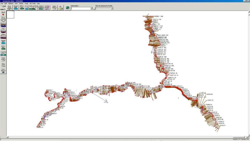
6 Georeferenced CDC Model 6
7 HEC-2 sample 7


8 Data Gathering DGN Files from October 1996 and March 2000 containing original cross sections Provided a starting point for acquiring geospatial coordinates for cross sections Gathered the CDC permit applications that corresponded with data gaps and coordinated with USACE 8


9 What was done? Georeferencing Previously USACE georeferenced streamlines and cross-sections were maintained in DGN file with original spatial coordinates Initial cross section locations were determined by importing the DGN file into GIS Identified which sections or reaches were missing, which sections had linear referencing, which sections were not based on model downstream reach lengths with mismatches in river stationing 9
10 What was done? Georeferencing Cross section profiles were generated in GIS from imported sections using 1991 topography. Each section profile was compared graphically in excel to model cross section data. GIS data is horizontally (X-coordinate) shifted. Plots provided a visual inspection of differences in beginning and end stations, comparison of section lengths, and comparison of section profiles, Model GIS Model GIS 10
11 Georeferencing Notes/ Recomendations Once georeferenced, some cross sections intersected. Typically near the end of cross sections in the left and right overbank area. Manually adjusted to eliminate crossing No impact to the model results, but revised topography in model sections needed Some cross sections could be re-aligned to follow model assumptions that section is perpendicular to flow No adjustments made Cross sections were extended and tied into higher elevations. Extensions were generally added in areas of ineffective flow. Necessary to generate flood inundation limits. Reassessment of the ineffective flow areas needed and refinement of cross section profile elevations Updates to cross sections as they relate to Letters of Map Revisions (LOMR) Changes needed to be made as they relate to revisions made clear during community comment period 11
12 What was done? Hydraulics Received HEC-RAS model (UT_CDC_RAS_2014) for the Upper Trinity dated 2014 RAMPP reviewed modeling and coordinated methodologies with USACE Revised Hydraulic Model Added revised flood flows Georeferenced all stream centerlines and cross sections Updated cross section down stream reach lengths based on georeferenced horizontal locations and river stations. RAMPP delivered the CDC Hydraulic package in FEMA standards and specifications to the Mapping Information Platform (MIP) 12
13 Special Considerations Hydraulics During the georeferencing process, GIS computed downstream reach length showed slight variations to what was input in the HEC-RAS model data Found when comparing different plans DNG workmap stream centerline used as basis for reach length computations Adjusted based on distances computed in GIS Overbank reach lengths revised based on the percent differences in calculated channel reach length 13
14 Special Considerations Hydraulics Cross section stationing was renamed based on the recalculated channel reach length of the georeferenced data Necessary per FEMA specifications New stationing names are consistent with the cumulative channel reach length Original CDC non-georeferenced stationing names are tracked in the HEC-RAS XS notes Cross section extension Many cross sections were originally truncated at the limits of effective flow or non-conveyance areas Does not capture the full floodplain extent Cross sections were extended in these cases Extension does not change the effective flow and does not affect the model simulation results Ineffective flow points were placed at the original termination point to ensure that the model computed the same effective flow with the extended cross section 14
15 Special Considerations Hydraulics Existing conditions consideration CDC model is maintained to represent proposed developments Some projects in the CDC model were not constructed Cross section changes due to these projects were restored to the 1991 condition based on the 1991 Terrain data to represent the existing conditions. Includes removal of the Dallas Floodway Extension (DFE) (Lamar levee and Cadillac Heights levee) The project list was finalized for the existing conditions model based on the date May 30th 2017 (USACE, 2017). 15
16 Flood Risk Review Meeting Comments and Responses CDC comments received by City of Arlington and City of Grand Prairie LOMRs Cases where LOMRs were not in the CDC model, which should not happen, based on permitting process. Several slight mismatches with the CDC model, based on final as-built conditions. Some LOMRs had more detailed local survey. Floodplain based on 1991 topography does not match Checked all LOMRs for these conditions and documented each case in the comments and disposition form. LOMR-Fs Revised a specific case request within City of Grand Prairie. City of Arlington commented on all LOMR-Fs in the community these will go through the revalidation process during Phase III. 16
17 Flood Risk Review Meeting Comments and Responses Bridge updates City of Arlington needed minor georeferencing adjustments for bridge hydraulic widths. Removed BLR Reclamation bridge as a future condition (does not affect WSELs) Additional minor floodplain mapping comments 17
18 Long-term Goals: Future CDC Considerations Tributary tie-ins to be refined and remapped with consideration for the backwater of the CDC model Document levee certification packages Incorporate bathymetry Leverage sources such as TRA supplied bathy to refine the model geometry Have a channel survey conducted and incorporate to augment existing sources Incorporate LiDAR Current overbank information from 1991 topo Replace 1991 overbank topo with more recent LiDAR Combine plans/geometries Currently 2 plans exist for events < 100 year and 500 year Geometries exist to handle split flow situations in the < 100 year events Ideal to have one plan and one geometry for all events Add Standard Project Flood (SPF) and CDC flows (based on future development) 18
19 Long-term Goals: Future CDC Considerations Channel and Overbank Flow paths Model should be inspected for changes in channel alignment and adjusted as needed Channel and overbank flow paths should be drawn taking into consideration current topography and floodplain delineation Updates to channel and flow path should be added to GIS, model, and stationing recalculated Currently recalculated based on a ratio between overbank reach lengths and applied to new reach lengths Modeled bridges in HEC-RAS Bridge contraction\expansion coefficients for bridge cross sections FEMA and HEC-RAS guidance are 0.3 and 0.5 CDC modeled at 0.1 and 0.3 XS layout There are some residual methods from HEC 2 geometry data capture. Example, reduce XS around structures in some cases there are XS stationed within a foot of each other. 19
20 Long-term Goals: Future CDC Considerations Channel Inverts Review channel inverts found XS 889 on EFS1 is several feet higher than surrounding sections Ground profile Higher than the 2- and 5-yr WSEL in some cases Negative depths Negative depths present in some cases Utilized updated Hydrology USACE is conducting a study of the Trinity Basin to include updated discharges Tentatively available September
21 Contact Information Jake Lesué Dewberry
HCFCD Review Process
 HCFCD Review Process Impact Analysis Local Review LOMR Delegation Local Review This presentation will include: Why is this step important? Process Review Checklist Common Comments 2 Local Review Why is
2D Model Implementation for Complex Floodplain Studies. Sam Crampton, P.E., CFM Dewberry
 2D Model Implementation for Complex Floodplain Studies Sam Crampton, P.E., CFM Dewberry 2D Case Studies Case Study 1 Rain-on-Grid 2D floodplain simulation for unconfined flat topography in coastal plain
2014 AWRA Annual Water Resources Conference November 5, 2014 Tysons Corner, VA
 2014 AWRA Annual Water Resources Conference November 5, 2014 Tysons Corner, VA HEC-RAS Overview, History, & Future How HEC-RAS Works Model Development Standard FEMA Assumptions Building A Model FEMA Levels
CHAPTER 7 FLOOD HYDRAULICS & HYDROLOGIC VIVEK VERMA
 CHAPTER 7 FLOOD HYDRAULICS & HYDROLOGIC VIVEK VERMA CONTENTS 1. Flow Classification 2. Chezy s and Manning Equation 3. Specific Energy 4. Surface Water Profiles 5. Hydraulic Jump 6. HEC-RAS 7. HEC-HMS
UNDERSTAND HOW TO SET UP AND RUN A HYDRAULIC MODEL IN HEC-RAS CREATE A FLOOD INUNDATION MAP IN ARCGIS.
 CE 412/512, Spring 2017 HW9: Introduction to HEC-RAS and Floodplain Mapping Due: end of class, print and hand in. HEC-RAS is a Hydrologic Modeling System that is designed to describe the physical properties
FLOODPLAIN MODELING MANUAL. HEC-RAS Procedures for HEC-2 Modelers
 FLOODPLAIN MODELING MANUAL HEC-RAS Procedures for HEC-2 Modelers Federal Emergency Management Agency Mitigation Directorate 500 C Street, SW Washington, DC 20472 April 2002 Floodplain Modeling Manual HEC-RAS
Efficiency and Accuracy of Importing HEC RAS Datafiles into PCSWMM and SWMM5
 5 Efficiency and Accuracy of Importing HEC RAS Datafiles into PCSWMM and SWMM5 Karen Finney, Rob James, William James and Tiehong Xiao An advantage of USEPA s SWMM5 is its capability to dynamically model
Linear Routing: Floodrouting. HEC-RAS Introduction. Brays Bayou. Uniform Open Channel Flow. v = 1 n R2/3. S S.I. units
 Linear Routing: Floodrouting HEC-RAS Introduction Shirley Clark Penn State Harrisburg Robert Pitt University of Alabama April 26, 2004 Two (2) types of floodrouting of a hydrograph Linear Muskingum Reservoir
The HEC-RAS Model Refresher
 The HEC-RAS Model Refresher Minmin Shu P.E. Transportation Review Unit Water Resources Division Michigan Department of Environmental Quality 12-6-2018 What Does the HEC-RAS Mean RAS----River Analysis System
WMS 9.1 Tutorial Hydraulics and Floodplain Modeling Floodplain Delineation Learn how to us the WMS floodplain delineation tools
 v. 9.1 WMS 9.1 Tutorial Hydraulics and Floodplain Modeling Floodplain Delineation Learn how to us the WMS floodplain delineation tools Objectives Experiment with the various floodplain delineation options
Flood Inundation Mapping using HEC-RAS
 Flood Inundation Mapping using HEC-RAS Goodell, C. 1 ; Warren, C. 2 WEST Consultants, 2601 25 th St SE, Suite 450, Salem, OR 97302. Abstract Flood inundation mapping is an important tool for municipal
SMS v D Summary Table. SRH-2D Tutorial. Prerequisites. Requirements. Time. Objectives
 SMS v. 12.3 SRH-2D Tutorial Objectives Learn the process of making a summary table to compare the 2D hydraulic model results with 1D hydraulic model results. This tutorial introduces a method of presenting
Prepared for CIVE 401 Hydraulic Engineering By Kennard Lai, Patrick Ndolo Goy & Dr. Pierre Julien Fall 2015
 Prepared for CIVE 401 Hydraulic Engineering By Kennard Lai, Patrick Ndolo Goy & Dr. Pierre Julien Fall 2015 Contents Introduction General Philosophy Overview of Capabilities Applications Computational
MEMORANDUM. Corona Subdivision XP Storm Evaluation. Date: March 5, Curt Bates, City of Petaluma. David S. Smith, P.E., WEST Consultants, Inc.
 MEMORANDUM Project: Corona Subdivision XP Storm Evaluation Subject: Results Summary Date: March 5, 2013 To: Curt Bates, City of Petaluma No. C056132 EXP. 12/31/14 From: David S. Smith, P.E., WEST Consultants,
Introducion to Hydrologic Engineering Centers River Analysis System (HEC- RAS) Neena Isaac Scientist D CWPRS, Pune -24
 Neena Isaac Scientist D CWPRS, Pune -24") Introducion to Hydrologic Engineering Centers River Analysis System (HEC- RAS) Neena Isaac Scientist D CWPRS, Pune -24 One dimensional river models (1-D models) Assumptions Flow is one dimensional Streamline
Introducion to Hydrologic Engineering Centers River Analysis System (HEC- RAS) Neena Isaac Scientist D CWPRS, Pune -24 One dimensional river models (1-D models) Assumptions Flow is one dimensional Streamline
Appendix E. HEC-RAS and HEC-Ecosystem Functions Models
 Appendix E HEC-RAS and HEC-Ecosystem Functions Models 1 Appendix E: Modeled Reaches for the Connecticut River Watershed application of HEC-RAS Separate from the report for the Decision Support System of
Harris County Flood Control District HEC-RAS 2D Modeling Guidelines (Standardizing HEC-RAS 2D Models for Submittal Within Harris County)
") Harris County Flood Control District HEC-RAS 2D Modeling Guidelines (Standardizing HEC-RAS 2D Models for Submittal Within Harris County) Presented by: April 27, 2017 Matthew Zeve, P.E., CFM Harris County
Harris County Flood Control District HEC-RAS 2D Modeling Guidelines (Standardizing HEC-RAS 2D Models for Submittal Within Harris County) Presented by: April 27, 2017 Matthew Zeve, P.E., CFM Harris County
Hydraulic Modeling with HEC RAS. Susan Cundiff, PE December 4, 2017
 Hydraulic Modeling with HEC RAS Susan Cundiff, PE December 4, 2017 Overview Introduction to HEC RAS Computational Procedures Building a Model Example Projects Introduction to HEC RAS U.S. Army Corps of
WMS 9.0 Tutorial Hydraulics and Floodplain Modeling HEC-RAS Analysis Learn how to setup a basic HEC-RAS analysis using WMS
 v. 9.0 WMS 9.0 Tutorial Hydraulics and Floodplain Modeling HEC-RAS Analysis Learn how to setup a basic HEC-RAS analysis using WMS Objectives Learn how to build cross sections, stream centerlines, and bank
2D Large Scale Automated Engineering for FEMA Floodplain Development in South Dakota. Eli Gruber, PE Brooke Conner, PE
 2D Large Scale Automated Engineering for FEMA Floodplain Development in South Dakota Eli Gruber, PE Brooke Conner, PE Project Acknowledgments FEMA Region 8 Staff: Brooke Conner, PE Casey Zuzak, GISP Ryan
WMS 10.1 Tutorial Hydraulics and Floodplain Modeling HEC-RAS Analysis Learn how to setup a basic HEC-RAS analysis using WMS
 v. 10.1 WMS 10.1 Tutorial Hydraulics and Floodplain Modeling HEC-RAS Analysis Learn how to setup a basic HEC-RAS analysis using WMS Objectives Learn how to build cross sections, stream centerlines, and
Comparing 2D Approaches for Complex FEMA Studies
 Comparing 2D Approaches for Complex FEMA Studies Presented by: Ted Cassidy, P.E., PH (STARR2-Dewberry) Sam Crampton, P.E., CFM (STARR2-Dewberry) Mike DePue, P.E., CFM (STARR2-Atkins) Agenda Introduction
Rapid Floodplain Delineation. Presented by: Leo R. Kreymborg 1, P.E. David T. Williams 2, Ph.D., P.E. Iwan H. Thomas 3, E.I.T.
 007 ASCE Rapid Floodplain Delineation Presented by: Leo R. Kreymborg 1, P.E. David T. Williams, Ph.D., P.E. Iwan H. Thomas 3, E.I.T. 1 Project Manager, PBS&J, 975 Sky Park Court, Suite 00, San Diego, CA
Watershed Modeling Rational Method Interface. Learn how to model urban areas using WMS' rational method interface
 v. 10.1 WMS 10.1 Tutorial Learn how to model urban areas using WMS' rational method interface Objectives Learn how to model urban areas using the Rational method, including how to compute rainfall intensity,
Floodplain Mapping & Hydraulic Analysis with HEC-GeoRAS and ArcGIS 9.1
 Floodplain Mapping & Hydraulic Analysis with HEC-GeoRAS 4.1.1 and ArcGIS 9.1 Prepared by Sarah Meyer 1 and Francisco Olivera 2, Ph.D., P.E. May 2007 Contents: 1. Goals of Exercise & Additional Resources
Steady Flow Water Surface Profile Computation Using HEC-RAS
 Steady Flow Water Surface Profile Computation Using HEC-RAS Objectives The objective of the course is to enable the participants to perform water surface profile computations using computer program HEC-RAS
2D Hydraulic Modeling, Steering Stream Restoration Design
 2D Hydraulic Modeling, Steering Stream Restoration Design PREPARED FOR: EcoStream 2018 Stream Ecology & Restoration Conference Presented By: Matthew D. Gramza, P.E., CFM, CPESC Civil & Environmental Consultants,
WMS 10.0 Tutorial Hydraulics and Floodplain Modeling HY-8 Modeling Wizard Learn how to model a culvert using HY-8 and WMS
 v. 10.0 WMS 10.0 Tutorial Hydraulics and Floodplain Modeling HY-8 Modeling Wizard Learn how to model a culvert using HY-8 and WMS Objectives Define a conceptual schematic of the roadway, invert, and downstream
PRACTICAL UNIT 1 exercise task
 Practical Unit 1 1 1 PRACTICAL UNIT 1 exercise task Developing a hydraulic model with HEC RAS using schematic river geometry data In the course of practical unit 1 we prepare the input for the execution
HEC-RAS. A Tutorial (Model Development of a Small Flume)
") HEC-RAS A Tutorial (Model Development of a Small Flume) HEC-RAS Hydraulic Engineering Center:River Analysis System 1-D step backwater model Utilizes energy equation to compute water surface elevation for
HEC-RAS A Tutorial (Model Development of a Small Flume) HEC-RAS Hydraulic Engineering Center:River Analysis System 1-D step backwater model Utilizes energy equation to compute water surface elevation for
George Mason University Department of Civil, Environmental and Infrastructure Engineering. Dr. Celso Ferreira
 George Mason University Department of Civil, Environmental and Infrastructure Engineering Dr. Celso Ferreira Exercise Topic: HEC GeoRAS Post-Processing Objectives: This tutorial is designed to walk you
Watershed Modeling HEC-HMS Interface
 v. 10.1 WMS 10.1 Tutorial Learn how to set up a basic HEC-HMS model using WMS Objectives Build a basic HEC-HMS model from scratch using a DEM, land use, and soil data. Compute the geometric and hydrologic
Cross Sections, Profiles, and Rating Curves. Viewing Results From The River System Schematic. Viewing Data Contained in an HEC-DSS File
 C H A P T E R 9 Viewing Results After the model has finished the steady or unsteady flow computations the user can begin to view the output. Output is available in a graphical and tabular format. The current
WMS 8.4 Tutorial Watershed Modeling MODRAT Interface Schematic Build a MODRAT model by defining a hydrologic schematic
 v. 8.4 WMS 8.4 Tutorial Watershed Modeling MODRAT Interface Schematic Build a MODRAT model by defining a hydrologic schematic Objectives This tutorial shows you how to define a basic MODRAT model using
2015 HDR, all rights reserved.
 2015 HDR, all rights reserved. An Alternative to HEC-GEORAS: Overview & Comparison of AutoCAD River & Flood Analysis Module Ron Branyon, PE, CFM George Doubleday, EIT, CFM Brandon Hilbrich, PE, CFM TFMA
WMS 10.0 Tutorial Watershed Modeling MODRAT Interface Schematic Build a MODRAT model by defining a hydrologic schematic
 v. 10.0 WMS 10.0 Tutorial Watershed Modeling MODRAT Interface Schematic Build a MODRAT model by defining a hydrologic schematic Objectives This tutorial shows users how to define a basic MODRAT model using
Comparison of 1D and 2D Surface Water Models for Solid Waste Facilities. Garth R. Bowers, P.E., Carl E. Bueter, P.E., Larry Henk
 Comparison of 1D and 2D Surface Water Models for Solid Waste Facilities Garth R. Bowers, P.E., Carl E. Bueter, P.E., Larry Henk Introduction Importance of Accurate Floodplain Delineation Required by Federal
Edward G. Beadenkopf, PE, CFM RAMPP-URS Corporation
 FEMA and Multi-Federal Agency Cooperation to Support Dam Safety and to Develop Tools for States and Local Communities to Create More Resilient Communities Edward G. Beadenkopf, PE, CFM RAMPP-URS Corporation
2-D Hydraulic Modeling Theory & Practice
 2-D Hydraulic Modeling Theory & Practice Author: Maged A. Aboelata, PhD, PE, CFM Presenter: Heather Zhao, PE, CFM October 2017 Presentation Outline * 1-D vs. 2-D modeling * Theory of 2-D simulation * Commonly
Build a MODRAT model by defining a hydrologic schematic
 v. 11.0 WMS 11.0 Tutorial Build a MODRAT model by defining a hydrologic schematic Objectives Learn how to define a basic MODRAT model using the hydrologic schematic tree in WMS by building a tree and defining
Watershed Analysis with the Hydrologic Engineering Center s River Analysis System (HEC-RAS)
") Watershed Analysis with the Hydrologic Engineering Center s River Analysis System (HEC-RAS) by Christopher R. Goodell and Gary W. Brunner PURPOSE: The objectives of this document are to provide a general
Watershed Analysis with the Hydrologic Engineering Center s River Analysis System (HEC-RAS) by Christopher R. Goodell and Gary W. Brunner PURPOSE: The objectives of this document are to provide a general
v. 9.1 WMS 9.1 Tutorial Watershed Modeling HEC-1 Interface Learn how to setup a basic HEC-1 model using WMS
 v. 9.1 WMS 9.1 Tutorial Learn how to setup a basic HEC-1 model using WMS Objectives Build a basic HEC-1 model from scratch using a DEM, land use, and soil data. Compute the geometric and hydrologic parameters
COMPARISON OF NUMERICAL HYDRAULIC MODELS APPLIED TO THE REMOVAL OF SAVAGE RAPIDS DAM NEAR GRANTS PASS, OREGON
 COMPARISON OF NUMERICAL HYDRAULIC MODELS APPLIED TO THE REMOVAL OF SAVAGE RAPIDS DAM NEAR GRANTS PASS, OREGON Jennifer Bountry, Hydraulic Engineer, Bureau of Reclamation, Denver, CO, jbountry@do.usbr.gov;
Learn how to link a hydrologic model to the SWMM storm drain model
 v. 10.1 WMS 10.1 Tutorial Learn how to link a hydrologic model to the SWMM storm drain model Objectives Build a rational method hydrologic model and compute sub-basin flows. Import storm drain network
Storm Drain Modeling HY-12 Rational Design
 v. 10.1 WMS 10.1 Tutorial Learn how to design storm drain inlets, pipes, and other components of a storm drain system using FHWA's HY-12 storm drain analysis software and the WMS interface Objectives Define
HEC RAS 2D Methods Guidance: South Dakota Large Scale Automated Engineering
 HEC RAS 2D Methods Guidance: South Dakota Large Scale Automated Engineering January, 2017 Prepared by: Compass PTS JV a JV led by AECOM and CDM Smith 3101 Wilson Boulevard, Suite 900 Arlington, VA 22201
HEC-RAS 3.0 January, 2001 Release Notes
 HEC-RAS 3.0 January, 2001 Release Notes A new version of HEC-RAS (3.0) has been released with significant new features over the previous version (2.21). Version 3.0 includes unsteady flow routing capabilities,
HEC-GeoRAS GIS Tools for Support of HEC-RAS using ArcGIS
 US Army Corps of Engineers Hydrologic Engineering Center HEC-GeoRAS GIS Tools for Support of HEC-RAS using ArcGIS User's Manual Version 4.2 September 2009 Approved for Public Release. Distribution Unlimited.
Storm Drain Modeling HY-12 Pump Station
 v. 10.1 WMS 10.1 Tutorial Storm Drain Modeling HY-12 Pump Station Analysis Setup a simple HY-12 pump station storm drain model in the WMS interface with pump and pipe information Objectives Using the HY-12
Using HEC-RAS and HEC-GeoRAS for River Modeling Adapted by E. Maurer, using an exercise by V. Merwade, Purdue Univ.
 Introduction Using HEC-RAS and HEC-GeoRAS for River Modeling Adapted by E. Maurer, using an exercise by V. Merwade, Purdue Univ. This tutorial uses the output from HEC_GeoRAS from a prior exercise as input
George Mason University Department of Civil, Environmental and Infrastructure Engineering. Dr. Celso Ferreira Prepared by Lora Baumgartner
 George Mason University Department of Civil, Environmental and Infrastructure Engineering Dr. Celso Ferreira Prepared by Lora Baumgartner Exercise Topic: Getting started with HEC GeoRAS Objective: Create
FLOODPLAIN MODELING USING HEC-RAS
 H A E S T A D M E T H O D S FLOODPLAIN MODELING USING HEC-RAS F i r s t E d i t i o n Authors Haestad Methods Gary Dyhouse Jennifer Hatchett Jeremy Benn Managing Editor Colleen Totz Editors David Klotz,
George Mason University Department of Civil, Environmental and Infrastructure Engineering. Dr. Celso Ferreira Prepared by Lora Baumgartner
 George Mason University Department of Civil, Environmental and Infrastructure Engineering Dr. Celso Ferreira Prepared by Lora Baumgartner Exercise Topic: Getting started with HEC RAS Objective: Create
City of Dallas Emergency Operation Center Response to May 2015 Flood Events
 City of Dallas Emergency Operation Center Response to May 2015 Flood Events Overview Storm Description Emergency Operations Overview After Action 2 Storm Description 3 Trinity River Watershed 4 Upper Trinity
HECRAS 2D: Are you ready for the revolution in the world of hydraulic modeling?
 HECRAS 2D: Are you ready for the revolution in the world of hydraulic modeling? Rishab Mahajan, Emily Campbell and Matt Bardol March 8, 2017 Outline Reasons for hydraulic modeling 1D Modeling 2D Modeling-
Updated on November 10, 2017
 CIVE 7397 Unsteady flows in Rivers and Pipe Networks/Stormwater Management and Modeling / Optimization in Water Resources Engineering Updated on November 10, 2017 Tutorial on using HEC-GeoRAS 10.1 (or
Urban Floodplain modeling- Application of Two-Dimensional Analyses to Refine Results
 Urban Floodplain modeling- Application of Two-Dimensional Analyses to Refine Results Prabharanjani Madduri, P.E., CFM Mathini Sreetharan, Ph.D., P.E., CFM Hydraulic modeling of urban areas and issues Modeling
Verification and Validation of HEC-RAS 5.1
 Verification and Validation of HEC-RAS 5.1 Gary Brunner 1, P.E., D. WRE, M.ASCE Dr. Alex Sanchez 1 Dr. Tom Molls 2 Dr. David Parr 3 1. USACE Hydrologic Engineering Center, Davis, CA 2. David Ford Consulting
Development and Evaluation of the Profile Synthesis Method for Approximate Floodplain Redelineation. Thomas A. Dickerson
 Development and Evaluation of the Profile Synthesis Method for Approximate Floodplain Redelineation Thomas A. Dickerson Thesis submitted to the faculty of the Virginia Polytechnic Institute and State University
Tutorial on using HEC-GeoRAS with ArcGIS 9.3
 Introduction Tutorial on using HEC-GeoRAS with ArcGIS 9.3 Prepared by Venkatesh Merwade School of Civil Engineering, Purdue University vmerwade@purdue.edu November 2009 This tutorial is designed to expose
1.0 INTRODUCTION. Subject: Peaking Analysis
 Memo Date: Friday, Project: NorthWestern Energy Operations Modeling of Hydros To: John Vandaveer, NorthWestern Energy From: Rick Miller, HDR Subject: Peaking Analysis 1.0 INTRODUCTION The goal of this
WMS 10.0 Tutorial Storm Drain Modeling SWMM Modeling Learn how to link a hydrologic model to the SWMM storm drain model
 v. 10.0 WMS 10.0 Tutorial Learn how to link a hydrologic model to the SWMM storm drain model Objectives Build a rational method hydrologic model and compute sub-basin flows. Import storm drain network
WMS 9.1 Tutorial Storm Drain Modeling SWMM Modeling Learn how to link a hydrologic model to the SWMM storm drain model
 v. 9.1 WMS 9.1 Tutorial Learn how to link a hydrologic model to the SWMM storm drain model Objectives Build a rational method hydrologic model and compute sub-basin flows. Import storm drain network information
2D Modeling for Approximate Areas. Monica S. Urisko, P.E. CFM
 2D Modeling for Approximate Areas Monica S. Urisko, P.E. CFM Ferrin P. Affleck, P.E. CFM Outline Types of Modeling Available Steady vs Unsteady 1D vs 2D Software available Basics of 2D modeling Inputs
Appendix E-1. Hydrology Analysis
 Appendix E-1 Hydrology Analysis July 2016 HYDROLOGY ANALYSIS For Tentative Tract 20049 City of Chino Hills County of San Bernardino Prepared For: 450 Newport Center Drive, Suite 300 Newport Beach, CA 92660
FMA 2D Challenge Models 2012
 Summary of the Participation in the 2D Modeling Challenges for 2012 Results of Challenge Models initially were presented at the 1 Day of 2D Symposium September 4, 2012 THOSE WHO PARTICIPATED IN PREPARING
The CaMa-Flood model description
 Japan Agency for Marine-Earth cience and Technology The CaMa-Flood model description Dai Yamazaki JAMTEC Japan Agency for Marine-Earth cience and Technology 4 th ep, 2015 Concepts of the CaMa-Flood development
WMS 8.4 Tutorial Watershed Modeling MODRAT Interface (GISbased) Delineate a watershed and build a MODRAT model
 Delineate a watershed and build a MODRAT model") v. 8.4 WMS 8.4 Tutorial Watershed Modeling MODRAT Interface (GISbased) Delineate a watershed and build a MODRAT model Objectives Delineate a watershed from a DEM and derive many of the MODRAT input parameters
v. 8.4 WMS 8.4 Tutorial Watershed Modeling MODRAT Interface (GISbased) Delineate a watershed and build a MODRAT model Objectives Delineate a watershed from a DEM and derive many of the MODRAT input parameters
WMS 10.1 Tutorial Hydraulics and Floodplain Modeling Simplified Dam Break Learn how to run a dam break simulation and delineate its floodplain
 v. 10.1 WMS 10.1 Tutorial Hydraulics and Floodplain Modeling Simplified Dam Break Learn how to run a dam break simulation and delineate its floodplain Objectives Setup a conceptual model of stream centerlines
Automating Hydraulic Analysis v 1.0.
 2011 Automating Hydraulic Analysis v 1.0. Basic tutorial and introduction Automating Hydraulic Analysis (AHYDRA) is a freeware application that automates some specific features of HEC RAS or other hydraulic
Spatial Hydrologic Modeling Using NEXRAD Rainfall Data in an HEC-HMS (MODClark) Model
 Model") v. 10.0 WMS 10.0 Tutorial Spatial Hydrologic Modeling Using NEXRAD Rainfall Data in an HEC-HMS (MODClark) Model Learn how to setup a MODClark model using distributed rainfall data Objectives Read an existing
v. 10.0 WMS 10.0 Tutorial Spatial Hydrologic Modeling Using NEXRAD Rainfall Data in an HEC-HMS (MODClark) Model Learn how to setup a MODClark model using distributed rainfall data Objectives Read an existing
FOR Save the Poudre: Poudre Waterkeeper BY PetersonGIS. Inputs, Methods, Results. June 15, 2012
 W e t l a n d s A n a l y s i s FOR Save the Poudre: Poudre Waterkeeper BY PetersonGIS Inputs, Methods, Results June 15, 2012 PROJECT GOALS The project goals were 1) create variable width buffers along
Lidar Talking Points Status of lidar collection in Pennsylvania Estimated cost and timeline
 Lidar Talking Points Pennsylvania has an immediate need for new lidar (topographic) data coverage. Some uses of the data are enumerated later in this document. USGS has calculated an average return on
Classwork 5 Using HEC-RAS for computing water surface profiles
 Classwork 5 Using HEC-RAS for computing water surface profiles (in collaboration with Dr. Ing. Luca Milanesi) Why classwork 5? This lecture will give us the possibility to make our first acquaintance with
Floodplain Risk Analysis Using Flood Probability and Annual Exceedance Probability Maps
 Brigham Young University BYU ScholarsArchive All Theses and Dissertations 2004-03-18 Floodplain Risk Analysis Using Flood Probability and Annual Exceedance Probability Maps Christopher M. Smemoe Brigham
Module 9. Lecture 3: Major hydrologic models-hspf, HEC and MIKE
 Lecture 3: Major hydrologic models-hspf, HEC and MIKE Major Hydrologic Models HSPF (SWM) HEC MIKE Hydrological Simulation Program-Fortran (HSPF) Commercial successor of the Stanford Watershed Model (SWM-IV)
C-BrEase. Copyright 2018 by H2FLO Consulting. All Rights Reserved.
 Copyright 2018 by H2FLO Consulting. All Rights Reserved. Table of contents Beginning... 4 Welcome... 4 Why?... 5 What's New?... 6 Release History... 6 Getting Started... 7 System requirements... 8 Evaluating...
Chapter 16. Table of Contents
 Table of Contents BANK FAILURE CALCULATIONS IN HEC-6T...16-1 Introduction...16-1 Approach...16-2 Conceptual Model...16-3 Theoretical Development...16-4 Two Foot Test...16-6 Mass Conservation...16-6 Command
HEC-RAS River Analysis System
 HEC-RAS River Analysis System Version 5.0.7 March 2019 Approved for Public Release. Distribution Unlimited. Introduction Version 5.0.7 of the River Analysis System (HEC-RAS) is now available. This Version
Initial Analysis of Natural and Anthropogenic Adjustments in the Lower Mississippi River since 1880
 Richard Knox CE 394K Fall 2011 Initial Analysis of Natural and Anthropogenic Adjustments in the Lower Mississippi River since 1880 Objective: The objective of this term project is to use ArcGIS to evaluate
Watershed Modeling Maricopa Predictive HEC-1 Model. Watershed Modeling Maricopa County: Master Plan Creating a Predictive HEC-1 Model
 v. 10.1 WMS 10.1 Tutorial Watershed Modeling Maricopa County: Master Plan Creating a Predictive HEC-1 Model Build a watershed model to predict hydrologic reactions based on land use development in Maricopa
Hydraulics and Floodplain Modeling Modeling with the Hydraulic Toolbox
 v. 9.1 WMS 9.1 Tutorial Hydraulics and Floodplain Modeling Modeling with the Hydraulic Toolbox Learn how to design inlet grates, detention basins, channels, and riprap using the FHWA Hydraulic Toolbox
Watershed Modeling Maricopa County: Master Plan Creating a Predictive HEC-1 Model
 v. 9.0 WMS 9.0 Tutorial Watershed Modeling Maricopa County: Master Plan Creating a Predictive HEC-1 Model Build a watershed model to predict hydrologic reactions based on land use development in Maricopa
Application of 2-D Modelling for Muda River Using CCHE2D
 Application of 2-D Modelling for Muda River Using CCHE2D ZORKEFLEE ABU HASAN, Lecturer, River Engineering and Urban Drainage Research Centre (REDAC), Universiti Sains Malaysia, Engineering Campus, Seri
Spatial Hydrologic Modeling HEC-HMS Distributed Parameter Modeling with the MODClark Transform
 v. 9.0 WMS 9.0 Tutorial Spatial Hydrologic Modeling HEC-HMS Distributed Parameter Modeling with the MODClark Transform Setup a basic distributed MODClark model using the WMS interface Objectives In this
AUTOMATING MANNING S N COEFFICIENT VALUE ASSIGNMENTS FOR HYDRAULIC MODELING
 Imagery Source: Bing Maps via ESRI AUTOMATING MANNING S N COEFFICIENT VALUE ASSIGNMENTS FOR HYDRAULIC MODELING Kyle Gallagher, GISP Black & Veatch Special Projects Corp. Project Overview USACE Tulsa District
EVALUATION OF HIGH-RESOLUTION DIGITAL ELEVATION MODELS FOR CREATING INUNDATION MAPS. Mark A. Wonkovich. A Thesis
 EVALUATION OF HIGH-RESOLUTION DIGITAL ELEVATION MODELS FOR CREATING INUNDATION MAPS Mark A. Wonkovich A Thesis Submitted to the Graduate College of Bowling Green State University in partial fulfillment
Module 7 Defining Coordinate Systems
 Module 7 Defining Coordinate Systems Introduction Objectives Outline of Topics Covered The use of coordinate systems is very important in managing 3D spatial data including point clouds. In this module
Flood Information Tool User Manual. Revision 7
 Flood Information Tool User Manual Revision 7 Developed for: NATIONAL INSTITUTE OF BUILDING SCIENCES 1090 Vermont Avenue, N.W., Suite 700 Washington, D.C. 20005-4905 1 April 2003 Copyright Notice Funding
Practice Workbook. Subsurface Utility Engineering Fundamentals
 Practice Workbook This workbook is designed for use in Live instructor-led training and for OnDemand selfstudy. The explanations and demonstrations are provided by the instructor in the classroom, or in
HEC-RAS Verification and Validation Tests
 HEC-RAS Verification and Validation Tests April 2018 Approved for Public Release. Distribution Unlimited. RD-52 REPORT DOCUMENTATION PAGE Form Approved OMB No. 0704-0188 The public reporting burden for
Day 1. HEC-RAS 1-D Training. Rob Keller and Mark Forest. Break (9:45 am to 10:00 am) Lunch (12:00 pm to 1:00 pm)
 Lunch (12:00 pm to 1:00 pm)") Day 1 HEC-RAS 1-D Training Rob Keller and Mark Forest Introductions and Course Objectives (8:00 am to 8:15 am) Introductions: Class and Content Module 1 Open Channel Hydraulics (8:15 am to 9:45 am) Lecture
Day 1 HEC-RAS 1-D Training Rob Keller and Mark Forest Introductions and Course Objectives (8:00 am to 8:15 am) Introductions: Class and Content Module 1 Open Channel Hydraulics (8:15 am to 9:45 am) Lecture
Ducks on the Pond: Stormwater Management Basin Analysis Using AutoCAD Civil 3D and Autodesk SSA
 Ducks on the Pond: Stormwater Management Basin Analysis Using AutoCAD Civil 3D and Autodesk Josh Kehs, P.E. Autodesk, Inc. CI4541 Learning Objectives At the end of this class, you will be able to: Model
WMS 9.1 Tutorial GSSHA Modeling Basics Stream Flow Integrate stream flow with your GSSHA overland flow model
 v. 9.1 WMS 9.1 Tutorial Integrate stream flow with your GSSHA overland flow model Objectives Learn how to add hydraulic channel routing to your GSSHA model and how to define channel properties. Learn how
FEMA Floodplain Mapping
 FEMA Floodplain Mapping By Luke Sturtevant Introduction The National Flood Insurance Program (NFIP) has compiled massive databases containing information and maps of floodplains for the entire United States.
Import, view, edit, convert, and digitize triangulated irregular networks
 v. 10.1 WMS 10.1 Tutorial Import, view, edit, convert, and digitize triangulated irregular networks Objectives Import survey data in an XYZ format. Digitize elevation points using contour imagery. Edit
Modeling Detention Ponds Malaysian Example (v2009)
") Modeling Detention Ponds Malaysian Example (v2009) This tutorial demonstrates the usability of xpswmm and xpstorm for simulating detention basins in urban areas. This fictitious example includes the use
Modeling Detention Ponds Malaysian Example (v2009) This tutorial demonstrates the usability of xpswmm and xpstorm for simulating detention basins in urban areas. This fictitious example includes the use
Hydrologic Modeling using HEC-HMS
 Hydrologic Modeling using HEC-HMS CE 412/512 Spring 2017 Introduction The intent of this exercise is to introduce you to the structure and some of the functions of the HEC-Hydrologic Modeling System (HEC-HMS),
Follow-Up on the Nueces River Groundwater Problem Uvalde Co. TX
 Follow-Up on the Nueces River Groundwater Problem Uvalde Co. TX Analysis by Ryan Kraft 12/4/2014 1 Problem Formulation A reduction in discharge was detected at a gauging station along a portion of the
Overview September 7, 2017
 Overview September 7, 2017 Purpose The purpose of this presentation is to provide an overview of the changes to the required deliverables and workflow for developing plans and models for Illinois DOT projects