Session 2 A virtual Observatory for TerraSAR-X data
|
|
|
- Ralf Boyd
- 5 years ago
- Views:
Transcription
1 Session 2 A virtual Observatory for TerraSAR-X data 2nd User Community Workshop Darmstadt, May 2012 Presenter: Mihai Datcu and Daniela Espinoza Molina (DLR)
2 This presentation contains contributions from: Quartulli, M; Datcu, M; 2012, Accelerated Compression Based CBIR, in preparation Dumitru, C. O. ; Datcu, M, TN KLAUS, Dec Blanchart, P; Ferecatu, M; Datcu. M; 2011, Cascaded Active Learning for Object Retrieval using Multiscale Coarse to Fine Analysis, in the proceedings of IEEE Conference on Image Processing (ICIP), Bruxelles, 2011 Shiyong Cui; Datcu, M.; 2011, Coarse to fine patches-based multitemporal analysis of very high resolution satellite images, Multi-Temp, Page(s): Popescu, A. A.; Gavat, I.; Datcu, M.; 2011, Contextual Descriptors for Scene Classes in Very High Resolution SAR Images, IEEE GRSL Bratasanu, D.; Nedelcu, I.; Datcu, M.; 2011, Interactive Spectral Band Discovery for Exploratory Visual Analysis of Satellite Images, IEEE JSTARS, Espinoza Molina, D.; Gleich, D.; Datcu, M.; 2011, Evaluation of Bayesian Despeckling and Texture Extraction Methods Based on Gauss Markov and Auto-Binomial Gibbs Random Fields: Application to TerraSAR-X IEEE TGRS (IEEEXPLORE early access) Birjandi, P.; Datcu, M.; 2010, Multiscale and Dimensionality Behavior of ICA Components for Satellite Image Indexing, IEEE GRSL, Volume: 7, Issue: 1, Page(s): Blanchart, P.; Datcu, M.; 2010, A Semi-Supervised Algorithm for Auto-Annotation and Unknown Structures Discovery in Satellite Image Databases, IEEE JSTARS, Volume: 3, Issue: 4, Part: 2, Page(s): Gueguen, L.; Datcu, M.; 2008, A Similarity Metric for Retrieval of Compressed Objects: Application for Mining Satellite Image Time Series IEEEE Transactions on Knowledge and Data Engineering, Volume: 20, Issue: 4, Page(s): Daschiel, H.; Datcu, M.; 2005, Design and evaluation of human-machine communication for image information mining, IEEE Transactions on Multimedia, Volume: 7, Issue: 6, Publication Year: 2005, Page(s): Datcu, M.; Seidel, K.; 2005, Human-centered concepts for exploration and understanding of Earth observation images IEEE TGRS, Volume: 43, Issue: 3, Page(s): Daschiel, H.; Datcu, M.; 2005 Information mining in remote sensing image archives: system evaluation IEEE TGRS, Volume: 43, Issue: 1, Page(s): Datcu, M.; et al.; Information mining in remote sensing image archives: system concepts IEEE TGRS, Volume: 41, Issue: 12, Part: 1, Page(s):

3


4
5 The Content of VHR EO Archives EO Archive = O { } EO Products EO product = image + xml file image = x pixels pixel = 16/32 /1000s bits, real/complex/multiband xml file = a lot about the imaging mode, orbit, position, timing TOTAL = many PetaBytes


6 Sensor resolution & Information Content 10m 4m 2m 1m 4 objects > 100 objects

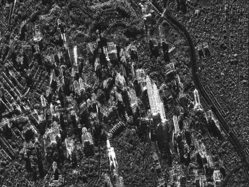
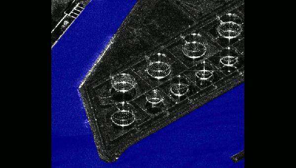
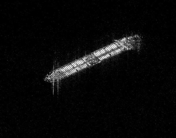
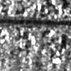
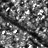
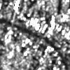
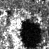
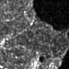
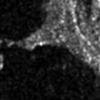
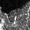
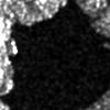
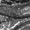
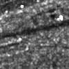
7 Spatial Context & Information Content Left: Example of typical ATR image (MSTAR database: T-72 battle tank): one isolated target on homogeneous background. Middle and right: HS TerraSAR-X examples of industrial/urban sites; middle patch: broad view of a harbor; right patch: close view of a district with skyscrapers. Conversely to ATR, we no longer have isolated objects, but rather complicated arrangements of targets. The number of individual objects is so high that we should work with Scene Classes instead of specific Objects
 and buildings (right) which are comprehensible only when the window size is sufficiently large to incorporate relevant context.")
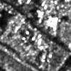
8 Spatial Context & Information Content At meter resolution, if context is ignored (the analysis windows being used are relatively small as compared to the object scale), very different scene classes may be confused. The example shows a bridge (left) and buildings (right) which are comprehensible only when the window size is sufficiently large to incorporate relevant context. Otherwise, both scene classes look similar and can be confused.


9 Scene Categories & Information Content 1 HS TerraSAR-X Scene = up to image patches (100 x 100 m)

10


11 Scene Evolution categories & Information Content Agriculture Forest House Lake Road


12 Multispectral and Spatial & Information Content WorldView 8 bands, 2 meter: spectral classes Spatial categories

13 Topology & Information Content A symbolic language?

14 Semantics & Information Content Define semantic annotation models

15 Product Metadata & Information Content XML file contains information about productcomponent, annotation, imagedata, missioninfo, acquisitioninfo, sceneinfo, etc Ontology queries Extraction of Metadata from XML annotation file
16 Number of acrchived scenes Number of archived scenes Number of archived TerraSAR-X scenes by country and incidence angle Spain Finland < < < < <60 Mid-range incidence angle 60 and larger 0 < < < < <60 Mid-range incidence angle 60 and larger The figure shows the number of archived TerraSAR-X scenes acquired over Spain and Finland at specific incidence angles. Almost half of the nearly 60 acquisitions over Spain were acquired with a mid-range incidence angle of between 30 and 40. Of a total of only six acqisitions over Finland two were acquired at each of the three 10 incicence angle ranges between 20 and 50.

17 The data archive The data access
18 Few Challenges The data and information processing performance The scalability issues need more detailed analysis as the volume, diversity and heterogeneity of data is continuously growing The end to end IIM process, i.e. the communication of the EO and related data content to the EO user needs special new solutions Fill the instrument gap also the semantic gap Provide an enriched index for the product catalogue Provide a base for a new type of interactive value added EO products Design the image and data representation for further auto-annotation and data mining processing.
19 TELEIOS Architecture
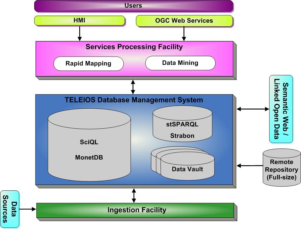
20 TELEIOS Architecture


21 Concept of Knowledge Discovery Query, Data Mining & Knowledge Discovery Data Sources Data Model Generation DBMS Visual Data Mining Users Interpretation Understanding
22 Functional Concepts Browsing: Navigation in the archive for discovering things. The direction, and goals of the navigation are changing based on the content of the queries. It gives a global image of the archive content. Searching: Navigation in the archive with a clear objective, the results of each query is used for directing the navigation. Annotation: Creation of new catalogue (index) entries for the archive. The result of browsing or searching may be used to annotate the results.
23 Exploration/Query Concepts Numeric and predefined queries: classical geographic position, time, senor type, etc. The output is a list of products in the specified parameters Semantic an numeric queries: by use of supporting frames a complex question can be formalized. The output is a list of products explained by the query sentence. Image similarity queries: search of similar images with a given example. The output is a ranked list of images. KDD: interactive search supported by relevance feedback mechanisms. The output is the desired product, the related products (containing similar information), semantically explained, or new, previously unknown information. Visual Data Mining: Visual exploration of the whole archive. The output are outliers, interesting groups, associations, etc.
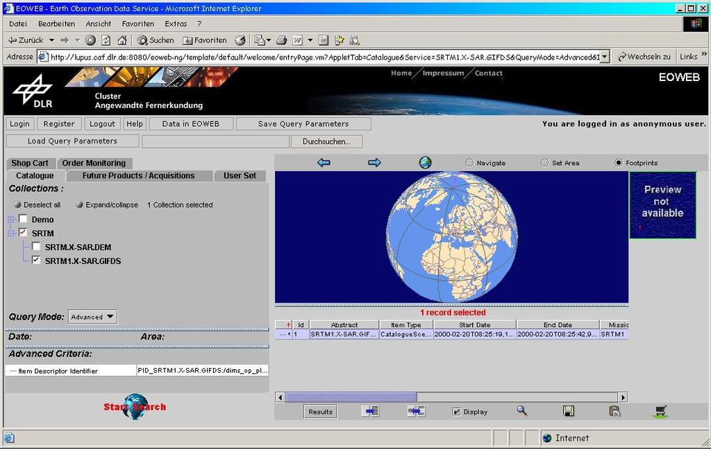
24 Queries using numerical descriptors and predefined keywords These state-of-the-art queries are based on basic image metadata such as coordinate systems, acquisition time, type of product, etc. The system allows functionalities such as navigations through the globe map, listing the available products in the image database, and placing an order for the desired products
")
25 Agenda (2/2)
26 Semantic and numerical queries Semantic Labels: The user can enter a simple label in the form of text or select an item from the available labels in the catalogue to perform the query (as for example forest ). We observe that these labels are pre-defined labels previously obtained as results of the image annotation process. Query language and Ontologies: Here, the queries can be performed either using only semantics or semantics and spatial content in the form of text or numerical entries. The queries based on spatial content are performed by using the image descriptors. The query language can rely on a query template in order to avoid mistyping and helping the user. Query Builder enabling queries by using semantics, topological relations, different operators, and numerical descriptors
")
27 Agenda (2/2)
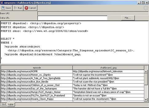
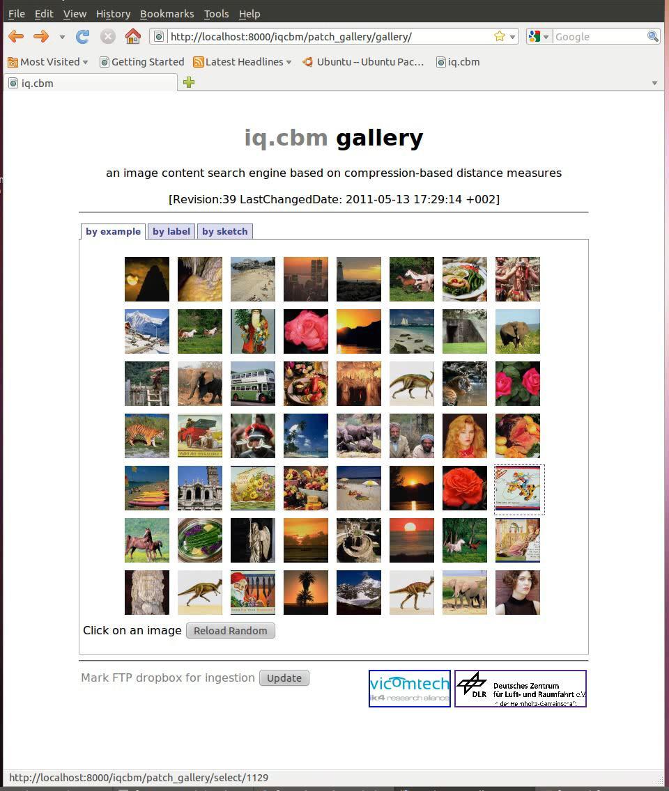
28 Query by example The knowledge discovery starts with a query based on image content as example. The user selects an image; later, its content is passed as example for the query, the system activates the data mining methods and retrieves the results The user selects the content of his interest by clicking on the image and the system retrieves the relevant images ranked according to some metrics
29 29


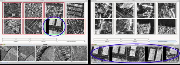
30 KDD, Active Learning and Auto-annotation KDD: interactive search supported by relevance feedback mechanisms. The output is the desired product, the related products (containing similar information), semantically explained, or new, previously unknown information learn the targeted image category as accurately and as exhaustively as possible minimize the number of iterations in the relevance feedback loop sys Query image user

31


32 Warning: not all categories can be learned!

33 Dec. Agenda (2/2)
34 Functions 1 Exploration & browsing: fast and controlled by Relevance Feedback 2 Search: fast reaching the target 3 Category learning, image groping and annotation: fast and well controlled by Relevance Feedback and Active Learning
35 Visual Data Mining Interactive exploration and analysis of very large, high complexity, and non-visual data sets. The analyst can navigate in a multi-modal space and interactively search and refine relevance criteria to explore patterns of interest in the data, and perform their in-depth analysis. Provides ensample views (projections) of the entire archive

36 Image Archive View Ontology and Knowledge Graph Jain IEEE TRANSACTIONS ON MULTIMEDIA, VOL. 10, NO. 2, FEBRUARY


37 Visual Data Mining Representation of the data in the 3D space using a Laplacian eigenmap Semantically consistent groupings appear inside the data


38 Rapid Mapping: Sources of Information and the Product EO Image Maps Maps GIS Text Manual integration Reports Statistics

39 Rapid Mapping

40 Rapid Mapping
41 Interactive Map
42 Interactive Map City
43 Interactive Map City

44 Interactive Map City Industry
45 Interactive Map City Industry
Session 2 A virtual Observatory for TerraSAR-X data
 Session 2 A virtual Observatory for TerraSAR-X data 3rd User Community Workshop Chania, 12-14 June 2013 Presenter: Mihai Datcu and Daniela Espinoza Molina (DLR) Motivation ENVISAT provided measurements
The Earth-Observation Image Librarian (EOLib): The data mining component of the TerraSAR-X Payload Ground Segment
: The data mining component of the TerraSAR-X Payload Ground Segment") The Earth-Observation Image Librarian (EOLib): The data mining component of the TerraSAR-X Payload Ground Segment Daniela Espinoza Molina, Vlad Manilici, Octavian Dumitru, Christoph Reck, Shiyong Cui,
The Earth-Observation Image Librarian (EOLib): The data mining component of the TerraSAR-X Payload Ground Segment Daniela Espinoza Molina, Vlad Manilici, Octavian Dumitru, Christoph Reck, Shiyong Cui,
EARTH-OBSERVATION DATA ACCESS: A KNOWLEDGE DISCOVERY CONCEPT FOR PAYLOAD GROUND SEGMENTS
 EARTH-OBSERVATION DATA ACCESS: A KNOWLEDGE DISCOVERY CONCEPT FOR PAYLOAD GROUND SEGMENTS Daniela Espinoza-Molina and Mihai Datcu German Aerospace Center, D-82234 Wessling - Germany ABSTRACT This paper
Design and Use of. Earth Observation Image Content Tools
 Design and Use of Earth Observation Image Content Tools Mihai Datcu (1, 2), Daniele Cerra (1), Houda Chaabouni-Chouayakh (1), Amaia de Miguel (1), Daniela Espinoza Molina (1), Gottfried Schwarz (1), Matteo
Image Information Mining (IIM): Where do we go?
: Where do we go?") Image Information Mining (IIM): Where do we go? Klaus Seidel and Mihai Datcu IGARSS 2004 The paradox People have normally trouble in caching more than 7 items at a time We design systems to enable people
Image Information Mining (IIM): Where do we go? Klaus Seidel and Mihai Datcu IGARSS 2004 The paradox People have normally trouble in caching more than 7 items at a time We design systems to enable people
TELEIOS FP Deliverable 3.1. KDD concepts and methods proposal: report & design recommendations
 TELEIOS FP7-257662 Deliverable 3.1 KDD concepts and methods proposal: report & design recommendations Corneliu Octavian Dumitru, Daniela Espinoza Molina, Shiyong Cui, Jagmal Singh, Marco Quartulli 1, Mihai
SEXTANT 1. Purpose of the Application
 SEXTANT 1. Purpose of the Application Sextant has been used in the domains of Earth Observation and Environment by presenting its browsing and visualization capabilities using a number of link geospatial
KES: Knowledge Enabled Services for better EO Information Use. Andrea Colapicchioni Advanced Computer Systems Space Division
 KES: Knowledge Enabled Services for better EO Information Use Andrea Colapicchioni Advanced Computer Systems Space Division a.colapicchioni@acsys.it The problem During the last decades, the satellite image
Architecture Concept for an Information Mining System for Earth Observation Data ABSTRACT
 Architecture Concept for an Information Mining System for Earth Observation Data Vlad Manilici, Stephan Kiemle, Christoph Reck, Mario Winkler German Aerospace Centre (DLR) Münchner Straße 20, 82234 Weßling,
Big, Linked and Open Earth Observation Data: the Projects TELEIOS and LEO
 Big, Linked and Open Earth Observation Data: the Projects TELEIOS and LEO Manolis Koubarakis Charalampos Nikolaou HELLENIC REPUBLIC National and Kapodistrian University of Athens Introduction TELEIOS:
A Content Based Image Retrieval System Based on Color Features
 A Content Based Image Retrieval System Based on Features Irena Valova, University of Rousse Angel Kanchev, Department of Computer Systems and Technologies, Rousse, Bulgaria, Irena@ecs.ru.acad.bg Boris
Contextual descriptors ad neural networks for scene analysis in VHR SAR images
 Workshop Nazionale La Missione COSMO-SkyMed: Stato dell Arte, Applicazioni e Prospettive Future Roma, 13-15 Novembre 2017 Contextual descriptors ad neural networks for scene analysis in VHR SAR images
Building Virtual Earth Observatories Using Scientific Database, Semantic Web and Linked Geospatial Data Technologies
 Building Virtual Earth Observatories Using Scientific Database, Semantic Web and Linked Geospatial Data Technologies Presenter: George Garbis ggarbis@di.uoa.gr Dept. of Informatics and Telecommunications
HIGH spatial resolution Earth Observation (EO) images
 images") JOURNAL OF L A TEX CLASS FILES, VOL. 6, NO., JANUARY 7 A Comparative Study of Bag-of-Words and Bag-of-Topics Models of EO Image Patches Reza Bahmanyar, Shiyong Cui, and Mihai Datcu, Fellow, IEEE Abstract
JOURNAL OF L A TEX CLASS FILES, VOL. 6, NO., JANUARY 7 A Comparative Study of Bag-of-Words and Bag-of-Topics Models of EO Image Patches Reza Bahmanyar, Shiyong Cui, and Mihai Datcu, Fellow, IEEE Abstract
GABOR AND WEBER FEATURE EXTRACTION PERFORMANCE BASED ON URBAN ATLAS GROUND TRUTH
 U.P.B. Sci. Bull., Series C, Vol. 78, Iss. 3, 2016 ISSN 2286-3540 GABOR AND WEBER FEATURE EXTRACTION PERFORMANCE BASED ON URBAN ATLAS GROUND TRUTH Mihaela STAN 1, Anca POPESCU 2, Dan Alexandru STOICHESCU
Strabon. Semantic support for EO Data Access in TELEIOS. Presenter: George Garbis
 Strabon Semantic support for EO Data Access in TELEIOS Presenter: George Garbis Dept. of Informatics and Telecommunications National and Kapodistrian University of Athens June 23 Florence, Italy Outline
Overview of Web Mining Techniques and its Application towards Web
 Overview of Web Mining Techniques and its Application towards Web *Prof.Pooja Mehta Abstract The World Wide Web (WWW) acts as an interactive and popular way to transfer information. Due to the enormous
1. Inroduction to Data Mininig
 1. Inroduction to Data Mininig 1.1 Introduction Universe of Data Information Technology has grown in various directions in the recent years. One natural evolutionary path has been the development of the
The Feature Analyst Extension for ERDAS IMAGINE
 The Feature Analyst Extension for ERDAS IMAGINE Automated Feature Extraction Software for GIS Database Maintenance We put the information in GIS SM A Visual Learning Systems, Inc. White Paper September
Multi-modal, multi-temporal data analysis for urban remote sensing
 Multi-modal, multi-temporal data analysis for urban remote sensing Xiaoxiang Zhu www.sipeo.bgu.tum.de 10.10.2017 Uncontrolled Growth in Mumbai Slums Leads to Massive Fires and Floods So2Sat: Big Data for
Welcome. to Pre-bid meeting. Karnataka State Spatial Data Infrastructure (KSSDI) Project, KSCST, Bangalore.
 Project, KSCST, Bangalore.") Welcome to Pre-bid meeting Karnataka State Spatial Data Infrastructure (KSSDI) Project, KSCST, Bangalore. DEVELOPMENT OF KARNATAKA STATE SPATIAL DATA INFRASTRUCTURE (KSSDI) PROJECT Objective: To develop
Welcome to Pre-bid meeting Karnataka State Spatial Data Infrastructure (KSSDI) Project, KSCST, Bangalore. DEVELOPMENT OF KARNATAKA STATE SPATIAL DATA INFRASTRUCTURE (KSSDI) PROJECT Objective: To develop
CHAPTER 8 Multimedia Information Retrieval
 CHAPTER 8 Multimedia Information Retrieval Introduction Text has been the predominant medium for the communication of information. With the availability of better computing capabilities such as availability
Data: a collection of numbers or facts that require further processing before they are meaningful
 Digital Image Classification Data vs. Information Data: a collection of numbers or facts that require further processing before they are meaningful Information: Derived knowledge from raw data. Something
Unsupervised Change Detection in Optical Satellite Images using Binary Descriptor
 Unsupervised Change Detection in Optical Satellite Images using Binary Descriptor Neha Gupta, Gargi V. Pillai, Samit Ari Department of Electronics and Communication Engineering, National Institute of Technology,
Contextual High-Resolution Image Classification by Markovian Data Fusion, Adaptive Texture Extraction, and Multiscale Segmentation
 IGARSS-2011 Vancouver, Canada, July 24-29, 29, 2011 Contextual High-Resolution Image Classification by Markovian Data Fusion, Adaptive Texture Extraction, and Multiscale Segmentation Gabriele Moser Sebastiano
Object-Based Classification & ecognition. Zutao Ouyang 11/17/2015
 Object-Based Classification & ecognition Zutao Ouyang 11/17/2015 What is Object-Based Classification The object based image analysis approach delineates segments of homogeneous image areas (i.e., objects)
GEOBIA for ArcGIS (presentation) Jacek Urbanski
 Jacek Urbanski") GEOBIA for ArcGIS (presentation) Jacek Urbanski INTEGRATION OF GEOBIA WITH GIS FOR SEMI-AUTOMATIC LAND COVER MAPPING FROM LANDSAT 8 IMAGERY Presented at 5th GEOBIA conference 21 24 May in Thessaloniki.
GEOBIA for ArcGIS (presentation) Jacek Urbanski INTEGRATION OF GEOBIA WITH GIS FOR SEMI-AUTOMATIC LAND COVER MAPPING FROM LANDSAT 8 IMAGERY Presented at 5th GEOBIA conference 21 24 May in Thessaloniki.
Parameter Free Image Artifacts Detection: A Compression Based Approach
 Parameter Free Image Artifacts Detection: A Compression Based Approach Avid Roman-Gonzalez a*, Mihai Datcu b a TELECOM ParisTech, 75013 Paris, France b German Aerospace Center (DLR), Oberpfaffenhofen ABSTRACT
International Journal of Computer Science Trends and Technology (IJCST) Volume 3 Issue 3, May-June 2015
 Volume 3 Issue 3, May-June 2015") RESEARCH ARTICLE OPEN ACCESS A Semantic Link Network Based Search Engine For Multimedia Files Anuj Kumar 1, Ravi Kumar Singh 2, Vikas Kumar 3, Vivek Patel 4, Priyanka Paygude 5 Student B.Tech (I.T) [1].
RESEARCH ARTICLE OPEN ACCESS A Semantic Link Network Based Search Engine For Multimedia Files Anuj Kumar 1, Ravi Kumar Singh 2, Vikas Kumar 3, Vivek Patel 4, Priyanka Paygude 5 Student B.Tech (I.T) [1].
Text Document Clustering Using DPM with Concept and Feature Analysis
 Available Online at www.ijcsmc.com International Journal of Computer Science and Mobile Computing A Monthly Journal of Computer Science and Information Technology IJCSMC, Vol. 2, Issue. 10, October 2013,
Rough Feature Selection for CBIR. Outline
 Rough Feature Selection for CBIR Instructor:Dr. Wojciech Ziarko presenter :Aifen Ye 19th Nov., 2008 Outline Motivation Rough Feature Selection Image Retrieval Image Retrieval with Rough Feature Selection
Columbia University High-Level Feature Detection: Parts-based Concept Detectors
 TRECVID 2005 Workshop Columbia University High-Level Feature Detection: Parts-based Concept Detectors Dong-Qing Zhang, Shih-Fu Chang, Winston Hsu, Lexin Xie, Eric Zavesky Digital Video and Multimedia Lab
ENVI Automated Image Registration Solutions
 ENVI Automated Image Registration Solutions Xiaoying Jin Harris Corporation Table of Contents Introduction... 3 Overview... 4 Image Registration Engine... 6 Image Registration Workflow... 8 Technical Guide...
Reducing Consumer Uncertainty
 Spatial Analytics Reducing Consumer Uncertainty Towards an Ontology for Geospatial User-centric Metadata Introduction Cooperative Research Centre for Spatial Information (CRCSI) in Australia Communicate
Data Exchange and Conversion Utilities and Tools (DExT)
") Data Exchange and Conversion Utilities and Tools (DExT) Louise Corti, Angad Bhat, Herve L Hours UK Data Archive CAQDAS Conference, April 2007 An exchange format for qualitative data Data exchange models
Data Exchange and Conversion Utilities and Tools (DExT) Louise Corti, Angad Bhat, Herve L Hours UK Data Archive CAQDAS Conference, April 2007 An exchange format for qualitative data Data exchange models
A Collaborative User-centered Approach to Fine-tune Geospatial
 A Collaborative User-centered Approach to Fine-tune Geospatial Database Design Grira Joel Bédard Yvan Sboui Tarek 16 octobre 2012 6th International Workshop on Semantic and Conceptual Issues in GIS - SeCoGIS
Figure 1: Workflow of object-based classification
 Technical Specifications Object Analyst Object Analyst is an add-on package for Geomatica that provides tools for segmentation, classification, and feature extraction. Object Analyst includes an all-in-one
CS377: Database Systems Data Warehouse and Data Mining. Li Xiong Department of Mathematics and Computer Science Emory University
 CS377: Database Systems Data Warehouse and Data Mining Li Xiong Department of Mathematics and Computer Science Emory University 1 1960s: Evolution of Database Technology Data collection, database creation,
Data publication and discovery with Globus
 Data publication and discovery with Globus Questions and comments to outreach@globus.org The Globus data publication and discovery services make it easy for institutions and projects to establish collections,
Towards an Ontology Visualization Tool for Indexing DICOM Structured Reporting Documents
 Towards an Ontology Visualization Tool for Indexing DICOM Structured Reporting Documents Sonia MHIRI sonia.mhiri@math-info.univ-paris5.fr Sylvie DESPRES sylvie.despres@lipn.univ-paris13.fr CRIP5 University
IMAGINE Objective. The Future of Feature Extraction, Update & Change Mapping
 IMAGINE ive The Future of Feature Extraction, Update & Change Mapping IMAGINE ive provides object based multi-scale image classification and feature extraction capabilities to reliably build and maintain
A State mosaic ready referral system
 A State mosaic ready referral system M.Nagamani, V. Subramanian, S. Rajendra Kumar, K.M.M. Rao National Remote Sensing Agency, Balanagar, Hyderabad 500-037, India. Keywords: Toposheet, Scale, Mosaic, Time
International Jmynal of Intellectual Advancements and Research in Engineering Computations
 www.ijiarec.com ISSN:2348-2079 DEC-2015 International Jmynal of Intellectual Advancements and Research in Engineering Computations VIRTUALIZATION OF DISTIRIBUTED DATABASES USING XML 1 M.Ramu ABSTRACT Objective
Analisi di immagini iperspettrali satellitari multitemporali: metodi ed applicazioni
 Analisi di immagini iperspettrali satellitari multitemporali: metodi ed applicazioni E-mail: bovolo@fbk.eu Web page: http://rsde.fbk.eu Outline 1 Multitemporal image analysis 2 Multitemporal images pre-processing
An Enhanced Image Retrieval Using K-Mean Clustering Algorithm in Integrating Text and Visual Features
 An Enhanced Image Retrieval Using K-Mean Clustering Algorithm in Integrating Text and Visual Features S.Najimun Nisha 1, Mrs.K.A.Mehar Ban 2, 1 PG Student, SVCET, Puliangudi. najimunnisha@yahoo.com 2 AP/CSE,
SK International Journal of Multidisciplinary Research Hub Research Article / Survey Paper / Case Study Published By: SK Publisher
 ISSN: 2394 3122 (Online) Volume 2, Issue 1, January 2015 Research Article / Survey Paper / Case Study Published By: SK Publisher P. Elamathi 1 M.Phil. Full Time Research Scholar Vivekanandha College of
Exploring GIS Data. I) GIS Data Models-Definitions II) Database Management System III) Data Source & Collection IV) Data Quality
 GIS Data Models-Definitions II) Database Management System III) Data Source & Collection IV) Data Quality") Exploring GIS Data I) GIS Data Models-Definitions II) Database Management System III) Data Source & Collection IV) Data Quality 1 Geographic data Model Definitions: Data : A collection of related facts
Exploring GIS Data I) GIS Data Models-Definitions II) Database Management System III) Data Source & Collection IV) Data Quality 1 Geographic data Model Definitions: Data : A collection of related facts
BAG-OF-VISUAL WORDS (BoVW) MODEL BASED APPROACH FOR CONTENT BASED IMAGE RETRIEVAL (CBIR) IN PEER TO PEER (P2P)NETWORKS.
 MODEL BASED APPROACH FOR CONTENT BASED IMAGE RETRIEVAL (CBIR) IN PEER TO PEER (P2P)NETWORKS.") BAG-OF-VISUAL WORDS (BoVW) MODEL BASED APPROACH FOR CONTENT BASED IMAGE RETRIEVAL (CBIR) IN PEER TO PEER (P2P)NETWORKS. 1 R.Lavanya, 2 E.Lavanya, 1 PG Scholar, Dept Of Computer Science Engineering,Mailam
BAG-OF-VISUAL WORDS (BoVW) MODEL BASED APPROACH FOR CONTENT BASED IMAGE RETRIEVAL (CBIR) IN PEER TO PEER (P2P)NETWORKS. 1 R.Lavanya, 2 E.Lavanya, 1 PG Scholar, Dept Of Computer Science Engineering,Mailam
DUE to their special capabilities, SAR sensors have always
 80 IEEE GEOSCIENCE AND REMOTE SENSING LETTERS, VOL. 9, NO. 1, JANUARY 2012 Contextual Descriptors for Scene Classes in Very High Resolution SAR Images Anca A. Popescu, Inge Gavat, Senior Member, IEEE,
Satellite-Based Earth Observation (EO), 6th Edition
, 6th Edition") Satellite-Based Earth Observation (EO), 6th Edition Report Brief - October 2014 www.nsr.com 2013 NSR Report Description The dynamic market for satellite-based imagery has been driven to new heights with
Satellite-Based Earth Observation (EO), 6th Edition Report Brief - October 2014 www.nsr.com 2013 NSR Report Description The dynamic market for satellite-based imagery has been driven to new heights with
Novetta Cyber Analytics
 Know your network. Arm your analysts. Introduction Novetta Cyber Analytics is an advanced network traffic analytics solution that empowers analysts with comprehensive, near real time cyber security visibility
MPEG-7. Multimedia Content Description Standard
 MPEG-7 Multimedia Content Description Standard Abstract The purpose of this presentation is to provide a better understanding of the objectives & components of the MPEG-7, "Multimedia Content Description
Earth Observation Image Semantic Bias: A Collaborative User Annotation Approach
 Earth Observation Image Semantic Bias: A Collaborative User Annotation Approach Ambar Murillo Montes de Oca, Reza Bahmanyar, Nicolae Nistor, and Mihai Datcu Fellow, IEEE Abstract Correctly annotated image
Web Services Annotation and Reasoning
 Web Services Annotation and Reasoning, W3C Workshop on Frameworks for Semantics in Web Services Web Services Annotation and Reasoning Peter Graubmann, Evelyn Pfeuffer, Mikhail Roshchin Siemens AG, Corporate
An Introduction to Content Based Image Retrieval
 CHAPTER -1 An Introduction to Content Based Image Retrieval 1.1 Introduction With the advancement in internet and multimedia technologies, a huge amount of multimedia data in the form of audio, video and
ISSN: , (2015): DOI:
: DOI:") www.ijecs.in International Journal Of Engineering And Computer Science ISSN:2319-7242 Volume 6 Issue 6 June 2017, Page No. 21737-21742 Index Copernicus value (2015): 58.10 DOI: 10.18535/ijecs/v6i6.31 A
www.ijecs.in International Journal Of Engineering And Computer Science ISSN:2319-7242 Volume 6 Issue 6 June 2017, Page No. 21737-21742 Index Copernicus value (2015): 58.10 DOI: 10.18535/ijecs/v6i6.31 A
Improving the Efficiency of Fast Using Semantic Similarity Algorithm
 International Journal of Scientific and Research Publications, Volume 4, Issue 1, January 2014 1 Improving the Efficiency of Fast Using Semantic Similarity Algorithm D.KARTHIKA 1, S. DIVAKAR 2 Final year
EVALUATION OF WORLDVIEW-1 STEREO SCENES AND RELATED 3D PRODUCTS
 EVALUATION OF WORLDVIEW-1 STEREO SCENES AND RELATED 3D PRODUCTS Daniela POLI, Kirsten WOLFF, Armin GRUEN Swiss Federal Institute of Technology Institute of Geodesy and Photogrammetry Wolfgang-Pauli-Strasse
Two Traditions of Metadata Development
 Two Traditions of Metadata Development Bibliographic control approach developed before computer technology and internet were commonplace. mainly used in libraries and universities. from early on used rules
Semantic-Based Surveillance Video Retrieval
 Semantic-Based Surveillance Video Retrieval Weiming Hu, Dan Xie, Zhouyu Fu, Wenrong Zeng, and Steve Maybank, Senior Member, IEEE IEEE Transactions on Image Processing, Vol. 16, No. 4, April 2007 Present
DATA FUSION AND INTEGRATION FOR MULTI-RESOLUTION ONLINE 3D ENVIRONMENTAL MONITORING
 DATA FUSION AND INTEGRATION FOR MULTI-RESOLUTION ONLINE 3D ENVIRONMENTAL MONITORING Yun Zhang, Pingping Xie, Hui Li Department of Geodesy and Geomatics Engineering, University of New Brunswick Fredericton,
CONTEXT-SENSITIVE VISUAL RESOURCE BROWSER
 CONTEXT-SENSITIVE VISUAL RESOURCE BROWSER Oleksiy Khriyenko Industrial Ontologies Group, Agora Center, University of Jyväskylä P.O. Box 35(Agora), FIN-40014 Jyväskylä, Finland ABSTRACT Now, when human
Chapter 1, Introduction
 CSI 4352, Introduction to Data Mining Chapter 1, Introduction Young-Rae Cho Associate Professor Department of Computer Science Baylor University What is Data Mining? Definition Knowledge Discovery from
Next-generation IT Platforms Delivering New Value through Accumulation and Utilization of Big Data
 Next-generation IT Platforms Delivering New Value through Accumulation and Utilization of Big Data 46 Next-generation IT Platforms Delivering New Value through Accumulation and Utilization of Big Data
CHANGE DETECTION OF LINEAR MAN-MADE OBJECTS USING FEATURE EXTRACTION TECHNIQUE
 CHANGE DETECTION OF LINEAR MAN-MADE OBJECTS USING FEATURE EXTRACTION TECHNIQUE S. M. Phalke and I. Couloigner Department of Geomatics Engineering, University of Calgary, Calgary, Alberta, Canada T2N 1N4
Information Management (IM)
") 1 2 3 4 5 6 7 8 9 Information Management (IM) Information Management (IM) is primarily concerned with the capture, digitization, representation, organization, transformation, and presentation of information;
1 2 3 4 5 6 7 8 9 Information Management (IM) Information Management (IM) is primarily concerned with the capture, digitization, representation, organization, transformation, and presentation of information;
Alphabet-Based Multisensory Data Fusion and Classification Using Factor Graphs
 IEEE JOURNAL OF SELECTED TOPICS IN APPLIED EARTH OBSERVATIONS AND REMOTE SENSING 1 Alphabet-Based Multisensory Data Fusion and Classification Using Factor Graphs Aliaksei Makarau, Gintautas Palubinskas,
IJREAT International Journal of Research in Engineering & Advanced Technology, Volume 1, Issue 5, Oct-Nov, 2013 ISSN:
 Semi Automatic Annotation Exploitation Similarity of Pics in i Personal Photo Albums P. Subashree Kasi Thangam 1 and R. Rosy Angel 2 1 Assistant Professor, Department of Computer Science Engineering College,
Information Retrieval System Based on Context-aware in Internet of Things. Ma Junhong 1, a *
 Information Retrieval System Based on Context-aware in Internet of Things Ma Junhong 1, a * 1 Xi an International University, Shaanxi, China, 710000 a sufeiya913@qq.com Keywords: Context-aware computing,
Ontology and Hyper Graph Based Dashboards in Data Warehousing Systems
 Ontology and Hyper Graph Based Dashboards in Data Warehousing Systems Gitanjali.J #1, C Ranichandra #2, Meera Kuriakose #3, Revathi Kuruba #4 # School of Information Technology and Engineering, VIT University
Multimodal Information Spaces for Content-based Image Retrieval
 Research Proposal Multimodal Information Spaces for Content-based Image Retrieval Abstract Currently, image retrieval by content is a research problem of great interest in academia and the industry, due
CHAPTER 6 PROPOSED HYBRID MEDICAL IMAGE RETRIEVAL SYSTEM USING SEMANTIC AND VISUAL FEATURES
 188 CHAPTER 6 PROPOSED HYBRID MEDICAL IMAGE RETRIEVAL SYSTEM USING SEMANTIC AND VISUAL FEATURES 6.1 INTRODUCTION Image representation schemes designed for image retrieval systems are categorized into two
Nearest Clustering Algorithm for Satellite Image Classification in Remote Sensing Applications
 Nearest Clustering Algorithm for Satellite Image Classification in Remote Sensing Applications Anil K Goswami 1, Swati Sharma 2, Praveen Kumar 3 1 DRDO, New Delhi, India 2 PDM College of Engineering for
UPDATING OBJECT FOR GIS DATABASE INFORMATION USING HIGH RESOLUTION SATELLITE IMAGES: A CASE STUDY ZONGULDAK
 UPDATING OBJECT FOR GIS DATABASE INFORMATION USING HIGH RESOLUTION SATELLITE IMAGES: A CASE STUDY ZONGULDAK M. Alkan 1, *, D. Arca 1, Ç. Bayik 1, A.M. Marangoz 1 1 Zonguldak Karaelmas University, Engineering
Tracking of video objects using a backward projection technique
 Tracking of video objects using a backward projection technique Stéphane Pateux IRISA/INRIA, Temics Project Campus Universitaire de Beaulieu 35042 Rennes Cedex, FRANCE ABSTRACT In this paper, we present
LSGI 521: Principles of GIS. Lecture 5: Spatial Data Management in GIS. Dr. Bo Wu
 Lecture 5: Spatial Data Management in GIS Dr. Bo Wu lsbowu@polyu.edu.hk Department of Land Surveying & Geo-Informatics The Hong Kong Polytechnic University Contents 1. Learning outcomes 2. From files to
Opus: University of Bath Online Publication Store
 Patel, M. (2004) Semantic Interoperability in Digital Library Systems. In: WP5 Forum Workshop: Semantic Interoperability in Digital Library Systems, DELOS Network of Excellence in Digital Libraries, 2004-09-16-2004-09-16,
Estimating Credibility of User Clicks with Mouse Movement and Eye-tracking Information
 Estimating Credibility of User Clicks with Mouse Movement and Eye-tracking Information Jiaxin Mao, Yiqun Liu, Min Zhang, Shaoping Ma Department of Computer Science and Technology, Tsinghua University Background
ENVI. Get the Information You Need from Imagery.
 Visual Information Solutions ENVI. Get the Information You Need from Imagery. ENVI is the premier software solution to quickly, easily, and accurately extract information from geospatial imagery. Easy
Content Based Image Retrieval (CBIR) Using Segmentation Process
 Using Segmentation Process") Content Based Image Retrieval (CBIR) Using Segmentation Process R.Gnanaraja 1, B. Jagadishkumar 2, S.T. Premkumar 3, B. Sunil kumar 4 1, 2, 3, 4 PG Scholar, Department of Computer Science and Engineering,
Content Based Image Retrieval (CBIR) Using Segmentation Process R.Gnanaraja 1, B. Jagadishkumar 2, S.T. Premkumar 3, B. Sunil kumar 4 1, 2, 3, 4 PG Scholar, Department of Computer Science and Engineering,
Content Based Medical Image Retrieval Using Fuzzy C- Means Clustering With RF
 Content Based Medical Image Retrieval Using Fuzzy C- Means Clustering With RF Jasmine Samraj #1, NazreenBee. M *2 # Associate Professor, Department of Computer Science, Quaid-E-Millath Government college
Information mining and information retrieval : methods and applications
 Information mining and information retrieval : methods and applications J. Mothe, C. Chrisment Institut de Recherche en Informatique de Toulouse Université Paul Sabatier, 118 Route de Narbonne, 31062 Toulouse
CGMS WMO Task Force on Metadata Implementation Progress. Presented to IPET-SUP agenda item 12.2
 CGMS WMO Task Force on Metadata Implementation Progress Presented to IPET-SUP 17-03-2015 agenda item 12.2 Overview CGMS-WMO-Task Force on Metadata Implementation Refresher Why such Task Force Task Force
Enterprise Manager: Scalable Oracle Management
 Session id:xxxxx Enterprise Manager: Scalable Oracle John Kennedy System Products, Server Technologies, Oracle Corporation Enterprise Manager 10G Database Oracle World 2003 Agenda Enterprise Manager 10G
The Geographic Names Register of the National Land Survey of Finland
 7 June 2002 English only Eighth United Nations Conference on the Standardization of Geographical Names Berlin, 27 August-5 September 2002 Item 12 (d) of the provisional agenda * Toponymic data files: automated
TUNNELINGS SYSTEM Inspection of brick tunnels and covered ways SSL (Circle, Hammersmith & City and District Lines) LONDON UNDERGROUND LIMITED
 LONDON UNDERGROUND LIMITED") TUNNELINGS SYSTEM Inspection of brick tunnels and covered ways SSL (Circle, Hammersmith & City and District Lines) LONDON UNDERGROUND LIMITED Inspection date: July 6 th 2014 Report date: September 22 nd
TUNNELINGS SYSTEM Inspection of brick tunnels and covered ways SSL (Circle, Hammersmith & City and District Lines) LONDON UNDERGROUND LIMITED Inspection date: July 6 th 2014 Report date: September 22 nd
Unsupervised and Self-taught Learning for Remote Sensing Image Analysis
 Unsupervised and Self-taught Learning for Remote Sensing Image Analysis Ribana Roscher Institute of Geodesy and Geoinformation, Remote Sensing Group, University of Bonn 1 The Changing Earth https://earthengine.google.com/timelapse/
Image Analysis With the Definiens Software Suite
 Image Analysis With the Definiens Software Suite Definiens Enterprise Image Intelligence Andreas Kühnen, Senior Sales Manager Malte Sohlbach, Systems Engineering Manager August 2009 Definiens AG 1986 Prof.
The EOC Geoservice: Standardized Access to Earth Observation Data Sets and Value Added Products ABSTRACT
 The EOC Geoservice: Standardized Access to Earth Observation Data Sets and Value Added Products K. Dengler, T. Heinen, A. Huber, K. Molch, E. Mikusch German Aerospace Center (DLR) German Remote Sensing
INTERACTIVE SEARCH FOR IMAGE CATEGORIES BY MENTAL MATCHING
 INTERACTIVE SEARCH FOR IMAGE CATEGORIES BY MENTAL MATCHING Donald GEMAN Dept. of Applied Mathematics and Statistics Center for Imaging Science Johns Hopkins University and INRIA, France Collaborators Yuchun
A SURVEY OF IMAGE MINING TECHNIQUES AND APPLICATIONS
 A SURVEY OF IMAGE MINING TECHNIQUES AND APPLICATIONS R. Vijayalatha Research Scholar, Manonmaniam Sundaranar University, Tirunelveli (India) ABSTRACT In the area of Data Mining, Image Mining technology
Semantic Mapping and Reasoning Approach for Mobile Robotics
 Semantic Mapping and Reasoning Approach for Mobile Robotics Caner GUNEY, Serdar Bora SAYIN, Murat KENDİR, Turkey Key words: Semantic mapping, 3D mapping, probabilistic, robotic surveying, mine surveying
Image Processing (IP)
") Image Processing Pattern Recognition Computer Vision Xiaojun Qi Utah State University Image Processing (IP) Manipulate and analyze digital images (pictorial information) by computer. Applications: The
Image Processing Pattern Recognition Computer Vision Xiaojun Qi Utah State University Image Processing (IP) Manipulate and analyze digital images (pictorial information) by computer. Applications: The
AN ENHANCED ATTRIBUTE RERANKING DESIGN FOR WEB IMAGE SEARCH
 AN ENHANCED ATTRIBUTE RERANKING DESIGN FOR WEB IMAGE SEARCH Sai Tejaswi Dasari #1 and G K Kishore Babu *2 # Student,Cse, CIET, Lam,Guntur, India * Assistant Professort,Cse, CIET, Lam,Guntur, India Abstract-
<is web> Information Systems & Semantic Web University of Koblenz Landau, Germany
 Information Systems & University of Koblenz Landau, Germany Semantic Search examples: Swoogle and Watson Steffen Staad credit: Tim Finin (swoogle), Mathieu d Aquin (watson) and their groups 2009-07-17
TERM BASED WEIGHT MEASURE FOR INFORMATION FILTERING IN SEARCH ENGINES
 TERM BASED WEIGHT MEASURE FOR INFORMATION FILTERING IN SEARCH ENGINES Mu. Annalakshmi Research Scholar, Department of Computer Science, Alagappa University, Karaikudi. annalakshmi_mu@yahoo.co.in Dr. A.
INFORMATION EXTRACTION USING OPTICAL AND RADAR REMOTE SENSING DATA FUSION ABSTRACT INTRODUCTION
 INFORMATION EXTRACTION USING OPTICAL AND RADAR REMOTE SENSING DATA FUSION Gintautas Palubinskas, Aliaksei Makarau and Peter Reinartz German Aerospace Center DLR Remote Sensing Technology Institute Oberpfaffenhofen,
Prof. Jose L. Flores, MS, PS Dept. of Civil Engineering & Surveying
 Prof. Jose L. Flores, MS, PS Dept. of Civil Engineering & Surveying Problem One of the challenges for any Geographic Information System (GIS) application is to keep the spatial data up to date and accurate.
An Overview of various methodologies used in Data set Preparation for Data mining Analysis
 An Overview of various methodologies used in Data set Preparation for Data mining Analysis Arun P Kuttappan 1, P Saranya 2 1 M. E Student, Dept. of Computer Science and Engineering, Gnanamani College of
M. Andrea Rodríguez-Tastets. I Semester 2008
 M. -Tastets Universidad de Concepción,Chile andrea@udec.cl I Semester 2008 Outline refers to data with a location on the Earth s surface. Examples Census data Administrative boundaries of a country, state