Exploring GIS Data. I) GIS Data Models-Definitions II) Database Management System III) Data Source & Collection IV) Data Quality
|
|
|
- Jared Pitts
- 5 years ago
- Views:
Transcription
1 Exploring GIS Data I) GIS Data Models-Definitions II) Database Management System III) Data Source & Collection IV) Data Quality 1
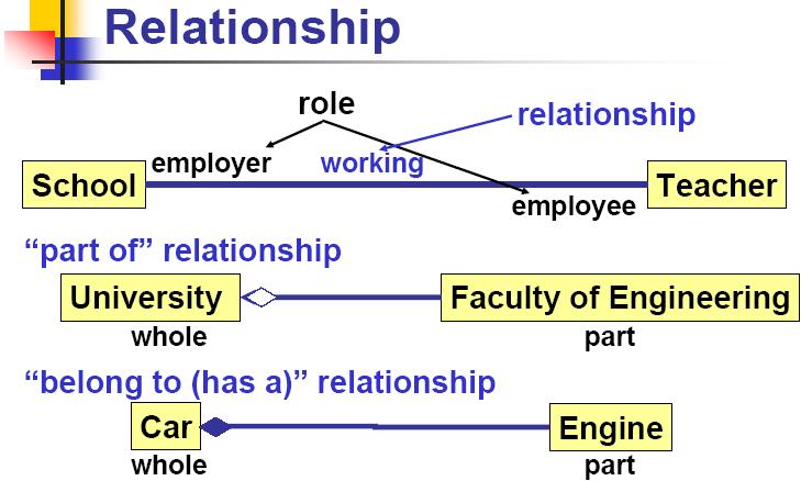
2 Geographic data Model Definitions: Data : A collection of related facts usually arranged in a particular format and gathered for a particular purpose. (as temperature,..) Information: Data which serves a purpose (as average of temperature,..) * Database: A collection of related files organized for efficient retrieval of information. Dataset or Layer: Any geographic data such as a shape file, coverage Geodatabase, or raster. 2
3 Geodatabase: A geographic database that is hosted inside a relational database management system that provides services for managing geographic data. These services include validation rules, relationships, and topological associations. Feature: A representation of a real-world object in a layer on a map. Field: A column in a table. Each field contains the values for a single attribute. 3

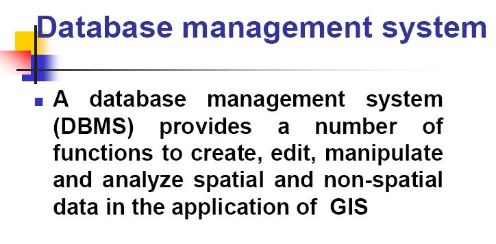
4 II) Database Management System 4
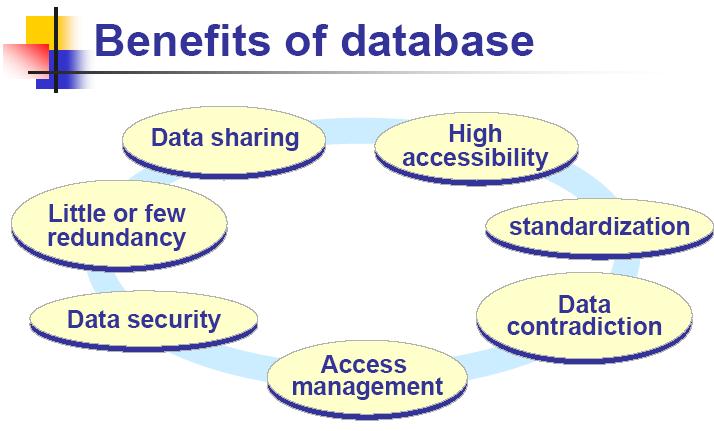
5 5
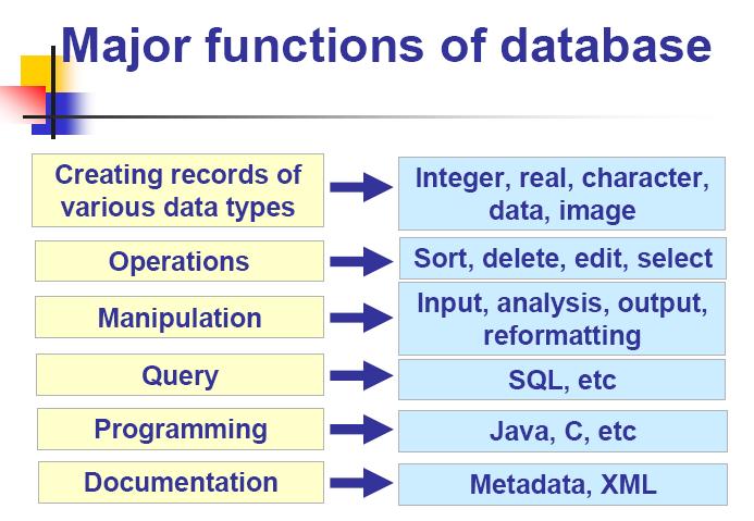
6 6
7 7
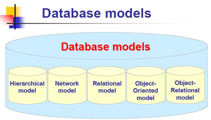
8 8
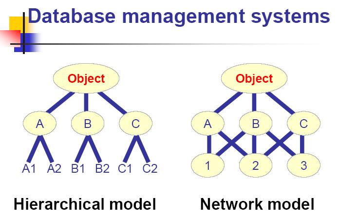
9 9
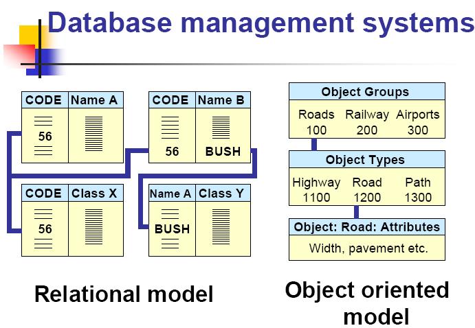
10 10
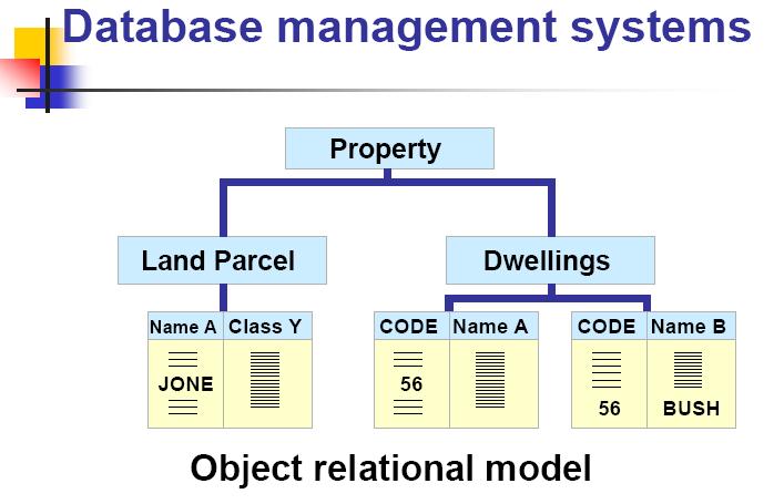
11 11
12 12
13 13
14 III) Data Sources for GIS Digital data Photogrammetry Maps and Plans Data GIS Paper files Interview s Data Remote Sensing GIS Data Sources Field survey 14
15 III) DATA SOURCES & COLLECTION Existing data digital map and plan paper files low cost acquisition remote sensing photogrammetry field survey high cost 15
16 III) DATA SOURCES & COLLECTION One of most expensive GIS activities Many diverse sources Two broad types of collection Data capture (direct collection) Data transfer Two broad capture methods Primary (direct measurement) Secondary (indirect derivation) 16
17 III) DATA SOURCES & COLLECTION Raster Vector Primary Digital remote sensing images Digital aerial photographs GPS measurements Survey measurements Secondary Scanned maps Topographic surveys DEMs from maps Toponymy data sets from atlases 17
18 Raster Primary Data Capture Capture specifically for GIS use Raster remote sensing e.g. SPOT and IKONOS satellites and aerial photography Passive and active sensors Resolution is key consideration Spatial Spectral Temporal Radiometric 18
19 Vector Primary Data Capture Surveying Locations of objects determines by angle and distance measurements from known locations Uses expensive field equipment and crews Most accurate method for large scale, small areas GPS Collection of satellites used to fix locations on Earth s surface Differential GPS used to improve accuracy 19
20 Raster Secondary Data Capture Data collected for other purposes can be converted for use in GIS Raster conversion Scanning of maps, aerial photographs, documents, etc Important scanning parameters are spatial and spectral (bit depth) resolution 20
21 Vector Secondary Data Capture Collection of vector objects from maps, photographs, plans, etc. Digitizing Manual (table) Heads-up and vectorization 21
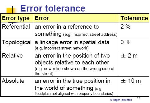
22 IV) Data Quality In the absence of a Data Quality Report, ask questions about undocumented data before you use it. What is the age of the data? Where did it come from? In what medium was it originally produced? To what map scale was the data digitized? What projection, coordinate system, and datum were used in maps? What was the density of observations used for its compilation? 22
23 V) Data Quality.. How accurate are positional and attribute features? Does the data seem logical and consistent? Is the data relevant to the project at hand? In what format is the data kept? How was the data checked? Why was the data compiled? What is the reliability of the provider? 23
24 24
25 Cost Quality Data Quality
26 Attribute Management_ types of fields Text Short Integer The text data type is a fixed length sequence of characters/text. This is the data type you will likely use to record most of your attribute data. Make sure that you set aside enough length to allow for your attribute descriptions. The most basic numeric data type is the short integer. The actual numeric value for a short integer is approximately between - 32,000 and +32,000. Both short and long integers can store only real numbers. That is to say that you cannot have fractions, or numbers to the right of the decimal place. To store data with decimal values, you will need to use either a float or a double data type. 26
27 Types of fields Long Integer Date The actual range for a long integer is approximately between -2 billion and +2 billion. Both short and long integers can store only real numbers. That is to say that you cannot have fractions, or numbers to the right of the decimal place. To store data with decimal values, you will need to use either a float or a double data type. The date data type can store dates, times, or date and times. The default format in which the information is presented is mm/dd/yyyy hh:mm:ss and a specification of AM or PM. When you enter date fields in the table, they will be converted to this format. 27
28 Types of fields Float Double Blob A float is a four-byte number and can store up to seven significant digits, both positive and negative. The double data type can also store decimals places. Leave the default precision and scale when you are adding floats. A double is an eight-byte number and can store up to 15 significant digits, both positive and negative. The double data type can also store decimals places. You will be using the double data type for your Latitude and Longitude fields. Leave the default precision and scale when you are adding doubles. A BLOB, stands for binary large object. This data type is for items such as images, multimedia, or bits of code that are too large to be stored as a other data types. 28
29 Summary Data collection is very expensive, timeconsuming, tedious and error prone Good procedures required for large scale collection projects Main techniques Primary Raster e.g. remote sensing Vector e.g. field survey Secondary Raster e.g. scanning Vector e.g. table digitizing
30 Thank You 30
9. GIS Data Collection
 9. GIS Data Collection Geographic Information Systems and Science SECOND EDITION Paul A. Longley, Michael F. Goodchild, David J. Maguire, David W. Rhind 2005 John Wiley and Sons, Ltd Overview Introduction
GIS Data Collection. This chapter reviews the main methods of GIS data capture and transfer and introduces key practical management issues.
 9 GIS Data Collection OVERVIEW This chapter reviews the main methods of GIS data capture and transfer and introduces key practical management issues. It distinguishes between primary (direct measurement)
ESRI China (Hong Kong) Limited
 Limited") Using Attribute Table Article ID : 100006 Software : ArcGIS Desktop 9.x Platform : Windows 2000, Windows XP Date : September 30, 2005 Background Sometimes the function provided in Attribute Table was overlooked
Using Attribute Table Article ID : 100006 Software : ArcGIS Desktop 9.x Platform : Windows 2000, Windows XP Date : September 30, 2005 Background Sometimes the function provided in Attribute Table was overlooked
MRR (Multi Resolution Raster) Revolutionizing Raster
 Revolutionizing Raster") MRR (Multi Resolution Raster) Revolutionizing Raster Praveen Gupta Praveen.Gupta@pb.com Pitney Bowes, Noida, India T +91 120 4026000 M +91 9810 659 350 Pitney Bowes, pitneybowes.com/in 5 th Floor, Tower
MRR (Multi Resolution Raster) Revolutionizing Raster Praveen Gupta Praveen.Gupta@pb.com Pitney Bowes, Noida, India T +91 120 4026000 M +91 9810 659 350 Pitney Bowes, pitneybowes.com/in 5 th Floor, Tower
These notes are designed to provide an introductory-level knowledge appropriate to understanding the basics of digital data formats.
 A brief guide to binary data Mike Sandiford, March 2001 These notes are designed to provide an introductory-level knowledge appropriate to understanding the basics of digital data formats. The problem
Topic 5: Raster and Vector Data Models
 Geography 38/42:286 GIS 1 Topic 5: Raster and Vector Data Models Chapters 3 & 4: Chang (Chapter 4: DeMers) 1 The Nature of Geographic Data Most features or phenomena occur as either: discrete entities
Contents of Lecture. Surface (Terrain) Data Models. Terrain Surface Representation. Sampling in Surface Model DEM
 Data Models. Terrain Surface Representation. Sampling in Surface Model DEM") Lecture 13: Advanced Data Models: Terrain mapping and Analysis Contents of Lecture Surface Data Models DEM GRID Model TIN Model Visibility Analysis Geography 373 Spring, 2006 Changjoo Kim 11/29/2006 1
Lecture 13: Advanced Data Models: Terrain mapping and Analysis Contents of Lecture Surface Data Models DEM GRID Model TIN Model Visibility Analysis Geography 373 Spring, 2006 Changjoo Kim 11/29/2006 1
GRASS GIS - Introduction
 GRASS GIS - Introduction What is a GIS A system for managing geographic data. Information about the shapes of objects. Information about attributes of those objects. Spatial variation of measurements across
GPS/GIS Activities Summary
 GPS/GIS Activities Summary Group activities Outdoor activities Use of GPS receivers Use of computers Calculations Relevant to robotics Relevant to agriculture 1. Information technologies in agriculture
FREE TUTORING. Digitizing a Map. 8 Geographers Tools: Automated Mapping. The Digitized Map. Revising a Digitized Map 9/28/2018. Next class: First Exam
 Next class: First Exam Tuesday, October 2, 2018. Combination of multiple choice questions and map interpretation. Bring a #2 pencil with eraser. Based on class lectures supplementing Chapter 1. Review
Terms and definitions * keep definitions of processes and terms that may be useful for tests, assignments
 Lecture 1 Core of GIS Thematic layers Terms and definitions * keep definitions of processes and terms that may be useful for tests, assignments Lecture 2 What is GIS? Info: value added data Data to solve
4.0 DIGITIZATION, EDITING AND STRUCTURING OF MAP DATA
 .0 DIGITIZATION, EDITING AND STRUCTURING OF MAP DATA The process of digitizing existing maps is a transformation from one analog) form of information to another digital) form. Data input is the operation
GIS in agriculture scale farm level - used in agricultural applications - managing crop yields, monitoring crop rotation techniques, and estimate
 Types of Input GIS in agriculture scale farm level - used in agricultural applications - managing crop yields, monitoring crop rotation techniques, and estimate soil loss from individual farms or agricultural
Object modeling and geodatabases. GEOG 419: Advanced GIS
 Object modeling and geodatabases GEOG 419: Advanced GIS CAD Data Model 1960s and 1970s Geographic data stored as points, lines, and areas No attributes; each feature type stored on a different layer No
Lecture 06. Raster and Vector Data Models. Part (1) Common Data Models. Raster. Vector. Points. Points. ( x,y ) Area. Area Line.
 Common Data Models. Raster. Vector. Points. Points. ( x,y ) Area. Area Line.") Lecture 06 Raster and Vector Data Models Part (1) 1 Common Data Models Vector Raster Y Points Points ( x,y ) Line Area Line Area 2 X 1 3 Raster uses a grid cell structure Vector is more like a drawn map
Lecture 06 Raster and Vector Data Models Part (1) 1 Common Data Models Vector Raster Y Points Points ( x,y ) Line Area Line Area 2 X 1 3 Raster uses a grid cell structure Vector is more like a drawn map
Metadata or "data about data" describe the content, quality, condition, and other characteristics of data. The Federal Geographic Data Committee
 Metadata or "data about data" describe the content, quality, condition, and other characteristics of data. The Federal Geographic Data Committee (http://www.fgdc.gov/) approved the Content Standard for
Understanding Geospatial Data Models
 Understanding Geospatial Data Models 1 A geospatial data model is a formal means of representing spatially referenced information. It is a simplified view of physical entities and a conceptualization of
Lecture 4: GIS Data Input Methods and Techniques. GE 118: INTRODUCTION TO GIS Engr. Meriam M. Santillan Caraga State University
 Lecture 4: GIS Data Input Methods and Techniques GE 118: INTRODUCTION TO GIS Engr. Meriam M. Santillan Caraga State University Geographic Data in GIS Can be obtained from various sources in different formats
Digital Elevation Models
 Digital Elevation Models National Elevation Dataset 1 Data Sets US DEM series 7.5, 30, 1 o for conterminous US 7.5, 15 for Alaska US National Elevation Data (NED) GTOPO30 Global Land One-kilometer Base
SPATIAL DATA MODELS Introduction to GIS Winter 2015
 SPATIAL DATA MODELS Introduction to GIS Winter 2015 GIS Data Organization The basics Data can be organized in a variety of ways Spatial location, content (attributes), frequency of use Come up with a system
UPDATING OBJECT FOR GIS DATABASE INFORMATION USING HIGH RESOLUTION SATELLITE IMAGES: A CASE STUDY ZONGULDAK
 UPDATING OBJECT FOR GIS DATABASE INFORMATION USING HIGH RESOLUTION SATELLITE IMAGES: A CASE STUDY ZONGULDAK M. Alkan 1, *, D. Arca 1, Ç. Bayik 1, A.M. Marangoz 1 1 Zonguldak Karaelmas University, Engineering
UNIT 7A Data Representation: Numbers and Text. Digital Data
 UNIT 7A Data Representation: Numbers and Text 1 Digital Data 10010101011110101010110101001110 What does this binary sequence represent? It could be: an integer a floating point number text encoded with
High resolution survey and orthophoto project of the Dosso-Gaya region in the Republic of Niger. by Tim Leary, Woolpert Inc.
 High resolution survey and orthophoto project of the Dosso-Gaya region in the Republic of Niger by Tim Leary, Woolpert Inc. Geospatial Solutions Photogrammetry & Remote Sensing LiDAR Professional Surveying
Lecture 2: GIS Data Sources, Data Types and Representation. GE 118: INTRODUCTION TO GIS Engr. Meriam M. Santillan Caraga State University
 Lecture 2: GIS Data Sources, Data Types and Representation GE 118: INTRODUCTION TO GIS Engr. Meriam M. Santillan Caraga State University Geographic Data in GIS Can be obtained from various sources in different
Class #2. Data Models: maps as models of reality, geographical and attribute measurement & vector and raster (and other) data structures
 data structures") Class #2 Data Models: maps as models of reality, geographical and attribute measurement & vector and raster (and other) data structures Role of a Data Model Levels of Data Model Abstraction GIS as Digital
Class #2 Data Models: maps as models of reality, geographical and attribute measurement & vector and raster (and other) data structures Role of a Data Model Levels of Data Model Abstraction GIS as Digital
An Introduction to Lidar & Forestry May 2013
 An Introduction to Lidar & Forestry May 2013 Introduction to Lidar & Forestry Lidar technology Derivatives from point clouds Applied to forestry Publish & Share Futures Lidar Light Detection And Ranging
Representing Geography
 Data models and axioms Chapters 3 and 7 Representing Geography Road map Representing the real world Conceptual models: objects vs fields Implementation models: vector vs raster Vector topological model
LSGI 521: Principles of GIS. Lecture 5: Spatial Data Management in GIS. Dr. Bo Wu
 Lecture 5: Spatial Data Management in GIS Dr. Bo Wu lsbowu@polyu.edu.hk Department of Land Surveying & Geo-Informatics The Hong Kong Polytechnic University Contents 1. Learning outcomes 2. From files to
GOVERNMENT GAZETTE REPUBLIC OF NAMIBIA
 GOVERNMENT GAZETTE OF THE REPUBLIC OF NAMIBIA N$7.20 WINDHOEK - 7 October 2016 No. 6145 CONTENTS Page GENERAL NOTICE No. 406 Namibia Statistics Agency: Data quality standard for the purchase, capture,
Programming in C++ 6. Floating point data types
 Programming in C++ 6. Floating point data types! Introduction! Type double! Type float! Changing types! Type promotion & conversion! Casts! Initialization! Assignment operators! Summary 1 Introduction
Spatial data and QGIS
 Spatial data and QGIS Xue Jingbo IT Center 2017.08.07 A GIS consists of: Spatial Data. Computer Hardware. Computer Software. Longitude Latitude Disease Date 26.870436-31.909519 Mumps 13/12/2008 26.868682-31.909259
CPSC 695. Data Quality Issues M. L. Gavrilova
 CPSC 695 Data Quality Issues M. L. Gavrilova 1 Decisions Decisions 2 Topics Data quality issues Factors affecting data quality Types of GIS errors Methods to deal with errors Estimating degree of errors
Creating an Environmental Database to Facilitate Groundwater Contamination Analysis. Jimmy Bowden Daniel B. Stephens and Associates
 Creating an Environmental Database to Facilitate Groundwater Contamination Analysis Jimmy Bowden Daniel B. Stephens and Associates Abstract Assigning responsibility for the cleanup of groundwater contamination
N.J.P.L.S. An Introduction to LiDAR Concepts and Applications
 N.J.P.L.S. An Introduction to LiDAR Concepts and Applications Presentation Outline LIDAR Data Capture Advantages of Lidar Technology Basics Intensity and Multiple Returns Lidar Accuracy Airborne Laser
The GIS Spatial Data Model
 The GIS Spatial Data Model Introduction: Spatial data are what drive a GIS. Every piece of functionality that makes a GIS separate from another analytical environment is rooted in the spatially explicit
About LIDAR Data. What Are LIDAR Data? How LIDAR Data Are Collected
 1 of 6 10/7/2006 3:24 PM Project Overview Data Description GIS Tutorials Applications Coastal County Maps Data Tools Data Sets & Metadata Other Links About this CD-ROM Partners About LIDAR Data What Are
Technical English -I 5 th week SURVEYING AND MAPPING
 Technical English -I 5 th week SURVEYING AND MAPPING What is surveying? It is the art of defining the positions of natural and man-made made features on the Earth s surface. Basic Tasks and Features in
Geodatabase over Taita Hills, Kenya
 Geodatabase over Taita Hills, Kenya Anna Broberg & Antero Keskinen Abstract This article introduces the basics of geographical information systems (GIS) and explains how the Taita Hills project can benefit
Introduction :- Storage of GIS Database :- What is tiling?
 Introduction :- GIS storage and editing subsystems provides a variety of tools for storing and maintaining the digital representation of a study area. It also provide tools for examining each theme for
Map Compilation CHAPTER HISTORY
 CHAPTER 7 Map Compilation 7.1 HISTORY Producing accurate commercial maps from aerial photography began in the 1930s. The technology of stereomapping over the last 70 years has brought vast technological
Number Systems. Both numbers are positive
 Number Systems Range of Numbers and Overflow When arithmetic operation such as Addition, Subtraction, Multiplication and Division are performed on numbers the results generated may exceed the range of
8 Geographers Tools: Automated Mapping. Digitizing a Map IMPORTANT 2/19/19. v Tues., Feb. 26, 2019.
 Next Class: FIRST EXAM v Tues., Feb. 26, 2019. Combination of multiple choice questions and map interpretation. Bring a #2 pencil with eraser. Based on class lectures supplementing Chapter 1. Review lectures
Welcome to NR402 GIS Applications in Natural Resources. This course consists of 9 lessons, including Power point presentations, demonstrations,
 Welcome to NR402 GIS Applications in Natural Resources. This course consists of 9 lessons, including Power point presentations, demonstrations, readings, and hands on GIS lab exercises. Following the last
Remote Sensing in an
 Chapter 2: Adding Data to a Map Document Remote Sensing in an ArcMap Environment Remote Sensing Analysis in an ArcMap Environment Tammy E. Parece Image source: landsat.usgs.gov Tammy Parece James Campbell
Airborne Laser Survey Systems: Technology and Applications
 Abstract Airborne Laser Survey Systems: Technology and Applications Guangping HE Lambda Tech International, Inc. 2323B Blue Mound RD., Waukesha, WI-53186, USA Email: he@lambdatech.com As mapping products
Classify Multi-Spectral Data Classify Geologic Terrains on Venus Apply Multi-Variate Statistics
 Classify Multi-Spectral Data Classify Geologic Terrains on Venus Apply Multi-Variate Statistics Operations What Do I Need? Classify Merge Combine Cross Scan Score Warp Respace Cover Subscene Rotate Translators
Geocoding and Georeferencing. Scott Bell GIS Institute
 Geocoding and Georeferencing Scott Bell GIS Institute Learning Outcomes Define coordinate system and map projection Relate coordinate systems and map projections Distinguish between defining and changing
POSITIONING A PIXEL IN A COORDINATE SYSTEM
 GEOREFERENCING AND GEOCODING EARTH OBSERVATION IMAGES GABRIEL PARODI STUDY MATERIAL: PRINCIPLES OF REMOTE SENSING AN INTRODUCTORY TEXTBOOK CHAPTER 6 POSITIONING A PIXEL IN A COORDINATE SYSTEM The essential
The Study for Mapping Policy and Topographic Mapping for Integrated National Development Plan in the Republic of the Philippines
 The Study for Mapping Policy and Topographic Mapping for Integrated National Development Plan in the Republic of the Philippines Japan International Cooperation Agency (JICA) National Mapping and Resources
THE CONTOUR TREE - A POWERFUL CONCEPTUAL STRUCTURE FOR REPRESENTING THE RELATIONSHIPS AMONG CONTOUR LINES ON A TOPOGRAPHIC MAP
 THE CONTOUR TREE - A POWERFUL CONCEPTUAL STRUCTURE FOR REPRESENTING THE RELATIONSHIPS AMONG CONTOUR LINES ON A TOPOGRAPHIC MAP Adrian ALEXEI*, Mariana BARBARESSO* *Military Equipment and Technologies Research
8 Geographers Tools: Automated Mapping. Digitizing a Map 2/19/19 IMPORTANT. Revising a Digitized Map. The Digitized Map. vtues., Feb. 26, 2019.
 Next Class: FIRST EXAM 8 Geographers Tools: Automated Mapping vtues., Feb. 26, 2019. Combination of multiple choice questions and map interpretation. Bring a #2 pencil with eraser. Based on class lectures
Files Used in this Tutorial
 Generate Point Clouds and DSM Tutorial This tutorial shows how to generate point clouds and a digital surface model (DSM) from IKONOS satellite stereo imagery. You will view the resulting point clouds
Technical Specifications
 1 Contents INTRODUCTION...3 ABOUT THIS LAB...3 IMPORTANCE OF THIS MODULE...3 EXPORTING AND IMPORTING DATA...4 VIEWING PROJECTION INFORMATION...5...6 Assigning Projection...6 Reprojecting Data...7 CLIPPING/SUBSETTING...7
Main concepts of ILWIS 3.0
 CHAPTER 2 Main concepts of ILWIS 3.0 In chapter one, Introduction to ILWIS, you started with ILWIS, and learned the basics of the user interface. This chapter presents some key concepts of ILWIS. In section
From Multi-sensor Data to 3D Reconstruction of Earth Surface: Innovative, Powerful Methods for Geoscience and Other Applications
 From Multi-sensor Data to 3D Reconstruction of Earth Surface: Innovative, Powerful Methods for Geoscience and Other Applications Bea Csatho, Toni Schenk*, Taehun Yoon* and Michael Sheridan, Department
ADAMS FUNCTIONAL DESCRIPTION FOR THE CORONA 350 II FLIR SYSTEMS POLYTECH AB
 ADAMS FUNCTIONAL DESCRIPTION FOR THE CORONA 350 II FLIR SYSTEMS POLYTECH AB Table of Contents Table of Contents... 1 Introduction... 2 Overview... 2 Purpose... 2 ADAMS Functional Description... 3 Setup
GPS Located Accuracy Assessment Plots on the Modoc National Forest
 This file was created by scanning the printed publication. Errors identified by the software have been corrected; however, some errors may remain. GPS Located Accuracy Assessment Plots on the Modoc National
LECTURE TWO Representations, Projections and Coordinates
 LECTURE TWO Representations, Projections and Coordinates GEOGRAPHIC COORDINATE SYSTEMS Why project? What is the difference between a Geographic and Projected coordinate system? PROJECTED COORDINATE SYSTEMS
Aerial photography: Principles. Visual interpretation of aerial imagery
 Aerial photography: Principles Visual interpretation of aerial imagery Overview Introduction Benefits of aerial imagery Image interpretation Elements Tasks Strategies Keys Accuracy assessment Benefits
EEOS 381 -Spatial Databases and GIS Applications
 EEOS 381 -Spatial Databases and GIS Applications Lecture 2 Data Sources Data Development and Data QA/QC Guiding Principle Good quality GIS data make up the foundation of all maps and spatial analyses and
Number Systems. Decimal numbers. Binary numbers. Chapter 1 <1> 8's column. 1000's column. 2's column. 4's column
 1's column 10's column 100's column 1000's column 1's column 2's column 4's column 8's column Number Systems Decimal numbers 5374 10 = Binary numbers 1101 2 = Chapter 1 1's column 10's column 100's
Spatial Data Models. Raster uses individual cells in a matrix, or grid, format to represent real world entities
 Spatial Data Models Raster uses individual cells in a matrix, or grid, format to represent real world entities Vector uses coordinates to store the shape of spatial data objects David Tenenbaum GEOG 7
v Working with Rasters SMS 12.1 Tutorial Requirements Raster Module Map Module Mesh Module Time minutes Prerequisites Overview Tutorial
 v. 12.1 SMS 12.1 Tutorial Objectives This tutorial teaches how to import a Raster, view elevations at individual points, change display options for multiple views of the data, show the 2D profile plots,
Specify Projection Customizing Projection Changing Projection
 Specify Projection Customizing Projection Changing Projection Click the Projection button FYI: To select zone pls. see in next slide From the View Menu, Choose Properties If a projection has already been
LORI COLLINS, RESEARCH ASSOCIATE PROFESSOR CONTRIBUTIONS BY: RICHARD MCKENZIE AND GARRETT SPEED, DHHC USF L IBRARIES
 LORI COLLINS, RESEARCH ASSOCIATE PROFESSOR CONTRIBUTIONS BY: RICHARD MCKENZIE AND GARRETT SPEED, DHHC USF L IBRARIES AERIAL AND TERRESTRIAL SURVEY WORKFLOWS Workflow from project planning applications
3 Data Storage 3.1. Foundations of Computer Science Cengage Learning
 3 Data Storage 3.1 Foundations of Computer Science Cengage Learning Objectives After studying this chapter, the student should be able to: List five different data types used in a computer. Describe how
Training i Course Remote Sensing Basic Theory & Image Processing Methods September 2011
 Training i Course Remote Sensing Basic Theory & Image Processing Methods 19 23 September 2011 Geometric Operations Michiel Damen (September 2011) damen@itc.nl ITC FACULTY OF GEO-INFORMATION SCIENCE AND
Interactive Maps Purpose: Login to the System: Interactive Maps ONTINUE AGREE
 Interactive Maps Purpose: The purpose of this application is to provide the facility to the citizen to navigate to a Property through an On-line Free Web Application in real time. The application uses
Introduction to Computer Science (I1100) Data Storage
 Data Storage") Data Storage 145 Data types Data comes in different forms Data Numbers Text Audio Images Video 146 Data inside the computer All data types are transformed into a uniform representation when they are stored
Data Storage 145 Data types Data comes in different forms Data Numbers Text Audio Images Video 146 Data inside the computer All data types are transformed into a uniform representation when they are stored
GEOGRAPHIC INFORMATION SYSTEMS Lecture 02: Feature Types and Data Models
 GEOGRAPHIC INFORMATION SYSTEMS Lecture 02: Feature Types and Data Models Feature Types and Data Models How Does a GIS Work? - a GIS operates on the premise that all of the features in the real world can
Managing Image Data on the ArcGIS Platform Options and Recommended Approaches
 Managing Image Data on the ArcGIS Platform Options and Recommended Approaches Peter Becker Petroleum requirements for imagery and raster Traditional solutions and issues Overview of ArcGIS imaging capabilities
Imagery and Raster Data in ArcGIS. Abhilash and Abhijit
 Imagery and Raster Data in ArcGIS Abhilash and Abhijit Agenda Imagery in ArcGIS Mosaic datasets Raster processing ArcGIS is a Comprehensive Imagery System Integrating All Types, Sources, and Sensor Models
Introduction Photogrammetry Photos light Gramma drawing Metron measure Basic Definition The art and science of obtaining reliable measurements by mean
 Photogrammetry Review Neil King King and Associates Testing is an art Introduction Read the question Re-Read Read The question What is being asked Answer what is being asked Be in the know Exercise the
APPENDIX E2. Vernal Pool Watershed Mapping
 APPENDIX E2 Vernal Pool Watershed Mapping MEMORANDUM To: U.S. Fish and Wildlife Service From: Tyler Friesen, Dudek Subject: SSHCP Vernal Pool Watershed Analysis Using LIDAR Data Date: February 6, 2014
Remote Sensing Introduction to the course
 Remote Sensing Introduction to the course Remote Sensing (Prof. L. Biagi) Exploitation of remotely assessed data for information retrieval Data: Digital images of the Earth, obtained by sensors recording
GIS data input. In the early days of GIS 1980s and early 1990s. We used canned datasets for teaching (from USA)
") GIS data input GIS is the automated : acquisition - input management analysis display of spatial data In the early days of GIS 1980s and early 1990s There were no or little GIS data We used canned datasets
GIS data input GIS is the automated : acquisition - input management analysis display of spatial data In the early days of GIS 1980s and early 1990s There were no or little GIS data We used canned datasets
Image georeferencing is the process of developing a model to transform from pixel coordinates into GIS coordinates such as meters on the ground.
 Image georeferencing is the process of developing a model to transform from pixel coordinates into GIS coordinates such as meters on the ground. Image rectification is the process of using your georeferencing
First Exam Thurs., Sept 28
 First Exam Thurs., Sept 28 Combination of multiple choice questions and map interpretation. Bring a #2 pencil with eraser. Based on class lectures supplementing chapter. Review lecture presentations 9.
Getting Started with the NH Stone Wall Mapper January 2019
 Getting Started with the NH Stone Wall Mapper January 2019 Stone walls are significant cultural and historical features of the New England landscape. Creating a statewide inventory of existing stone walls
Binary. Hexadecimal BINARY CODED DECIMAL
 Logical operators Common arithmetic operators, like plus, minus, multiply and divide, works in any number base but the binary number system provides some further operators, called logical operators. Meaning
proctool_owl_v2.1 AisaOWL pre-processing tool quick operation instructions
 proctool_owl_v2.1 AisaOWL pre-processing tool quick operation instructions Doc.Ver. 1.1 30.05. 2014 / Hannu Holma, Specim System requirements Operating system: 64 bit Windows Installation 1. Run Matlab
Government of Alberta. Find Your Farm. Alberta Soil Information Viewer. Alberta Agriculture and Forestry [Date]
![Government of Alberta. Find Your Farm. Alberta Soil Information Viewer. Alberta Agriculture and Forestry [Date]](/thumbs/83/87435202.jpg "Government of Alberta. Find Your Farm. Alberta Soil Information Viewer. Alberta Agriculture and Forestry [Date]") Government of Alberta Find Your Farm Alberta Soil Information Viewer Alberta Agriculture and Forestry [Date] Contents Definitions... 1 Getting Started... 2 Area of Interest... 3 Search and Zoom... 4 By
Government of Alberta Find Your Farm Alberta Soil Information Viewer Alberta Agriculture and Forestry [Date] Contents Definitions... 1 Getting Started... 2 Area of Interest... 3 Search and Zoom... 4 By
Lecture 4. Image Georeferencing, Accuracy and Precision, File Geodatabase
 Lecture 4 Image Georeferencing, Accuracy and Precision, File Geodatabase Tomislav Sapic GIS Technologist Faculty of Natural Resources Management Lakehead University Why Georeference? Images of the surface
Geometry of Aerial photogrammetry. Panu Srestasathiern, PhD. Researcher Geo-Informatics and Space Technology Development Agency (Public Organization)
") Geometry of Aerial photogrammetry Panu Srestasathiern, PhD. Researcher Geo-Informatics and Space Technology Development Agency (Public Organization) Image formation - Recap The geometry of imaging system
Geometry of Aerial photogrammetry Panu Srestasathiern, PhD. Researcher Geo-Informatics and Space Technology Development Agency (Public Organization) Image formation - Recap The geometry of imaging system
LIDAR MAPPING FACT SHEET
 1. LIDAR THEORY What is lidar? Lidar is an acronym for light detection and ranging. In the mapping industry, this term is used to describe an airborne laser profiling system that produces location and
Digital Elevation Models (DEM)
") Digital Elevation Models (DEM) Digital representation of the terrain surface also referred to as Digital Terrain Models (DTM) Digital Elevation Models (DEM) How has relief depiction changed with digital
Digital Elevation Models (DEM) Digital representation of the terrain surface also referred to as Digital Terrain Models (DTM) Digital Elevation Models (DEM) How has relief depiction changed with digital
M. Andrea Rodríguez-Tastets. I Semester 2008
 M. -Tastets Universidad de Concepción,Chile andrea@udec.cl I Semester 2008 Outline refers to data with a location on the Earth s surface. Examples Census data Administrative boundaries of a country, state
ORTHOPHOTO PRODUCTION FROM AERIAL PHOTOGRAPH BY USING MATLAB AND GIS
 International Journal of Civil Engineering and Technology (IJCIET) Volume 9, Issue 9, September 2018, pp. 156 164, Article ID: IJCIET_09_09_018 Available online at http://www.iaeme.com/ijciet/issues.asp?jtype=ijciet&vtype=9&itype=9
Advanced Data Types and New Applications
 Advanced Data Types and New Applications These slides are a modified version of the slides of the book Database System Concepts (Chapter 24), 5th Ed., McGraw-Hill, by Silberschatz, Korth and Sudarshan.
Data Representation and Networking
 Data Representation and Networking Instructor: Dmitri A. Gusev Spring 2007 CSC 120.02: Introduction to Computer Science Lecture 3, January 30, 2007 Data Representation Topics Covered in Lecture 2 (recap+)
Site View Reconstruction for Urban Planning Using ArcGIS, Google Sketch up and Google Earth
 Site View Reconstruction for Urban Planning Using ArcGIS, Google Sketch up and Google Earth A Case Study of the University of Nigeria Enugu Campus Ndukwu, Raphael Ike Department of Geoinformatics & Surveying
Accessing Data Where it Lives
 Accessing Data Where it Lives Session 3A Steve Carr TSI Tyson Haverkort Safe Software Session Description We ll discuss many types of data that can be used in MapInfo Professional such as: Business Data
Introduction to LiDAR
 Introduction to LiDAR Our goals here are to introduce you to LiDAR data. LiDAR data is becoming common, provides ground, building, and vegetation heights at high accuracy and detail, and is available statewide.
Chapter 3: Maps as Numbers
 Chapter 3: Maps as Numbers 3. Representing Maps as Numbers 3.2 Structuring Attributes 3.3 Structuring Maps 3.4 Why Topology Matters 3.5 Formats for GIS Data 3.6 Exchanging Data David Tenenbaum EEOS 265
Creating Digital Elevation Model Using a Mobile Device
 Name : Ali Ihsan Durmaz UnitID : aidurmaz Creating Digital Elevation Model Using a Mobile Device ABSTRACT DEM (Digital Elevation Models) is the best way to interpret topography on the ground. In recent
All data is in Universal Transverse Mercator (UTM) Zone 6 projection, and WGS 84 datum.
 Zone 6 projection, and WGS 84 datum.") 111 Mulford Hall, College of Natural Resources, UC Berkeley (510) 643-4539 EXPLORING MOOREA DATA WITH QUANTUM GIS In this exercise, you will be using an open-source FREE GIS software, called Quantum GIS,
111 Mulford Hall, College of Natural Resources, UC Berkeley (510) 643-4539 EXPLORING MOOREA DATA WITH QUANTUM GIS In this exercise, you will be using an open-source FREE GIS software, called Quantum GIS,
Review of Cartographic Data Types and Data Models
 Review of Cartographic Data Types and Data Models GIS Data Models Raster Versus Vector in GIS Analysis Fundamental element used to represent spatial features: Raster: pixel or grid cell. Vector: x,y coordinate
The Raster Data Model
 The Raster Data Model 2 2 2 2 8 8 2 2 8 8 2 2 2 2 2 2 8 8 2 2 2 2 2 2 2 2 2 Llano River, Mason Co., TX 1 Rasters are: Regular square tessellations Matrices of values distributed among equal-sized, square
Terrain Modeling and Mapping for Telecom Network Installation Using Scanning Technology. Maziana Muhamad
 Terrain Modeling and Mapping for Telecom Network Installation Using Scanning Technology Maziana Muhamad Summarising LiDAR (Airborne Laser Scanning) LiDAR is a reliable survey technique, capable of: acquiring