Building Virtual Earth Observatories Using Scientific Database, Semantic Web and Linked Geospatial Data Technologies
|
|
|
- Marilynn Bennett
- 5 years ago
- Views:
Transcription

1 Building Virtual Earth Observatories Using Scientific Database, Semantic Web and Linked Geospatial Data Technologies Presenter: George Garbis Dept. of Informatics and Telecommunications National and Kapodistrian University of Athens 1
2 Outline Motivation for project TELEIOS State of the art in Earth Observation data centers Developing Virtual Earth Observatories using ontologies and linked geospatial data Some technical highlights 2
3 Motivation 3
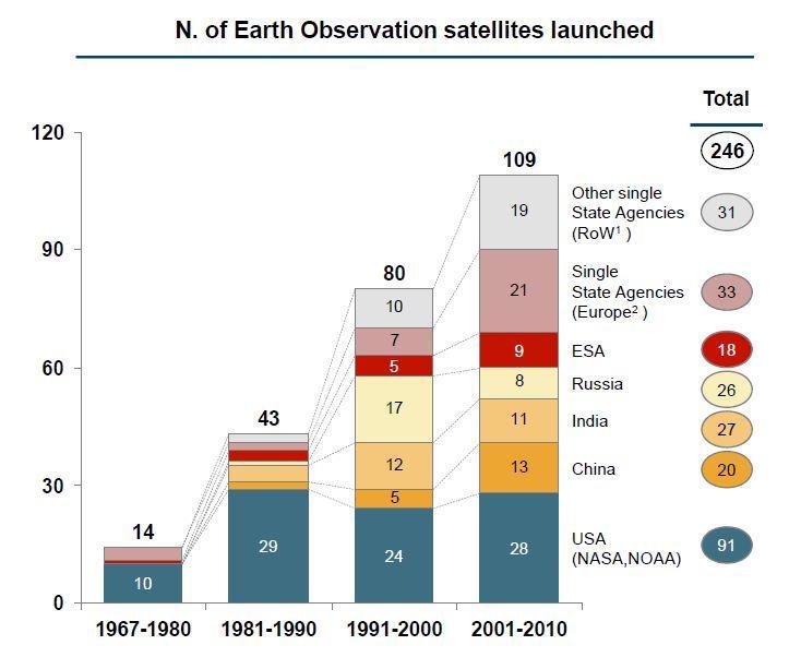
4 Motivation (cont d) ~20 PB 4


5 State of the Art in EO Data Centers Users EOWEB EO data center Catalogue Raw Data Processing Chains Archive 5
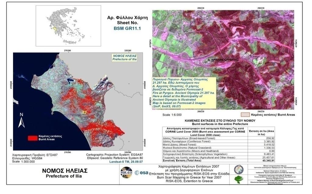
6 Example Can I pose the following query using EOWEB? Find images taken by the SEVIRI satellite on August 25, 2007 which contain fire hotspots in areas which have been classified as forests according to CORINE Land Cover, and are located within 2km from an archaeological site in the Peloponnese. 6
")
7 Example (cont d) 7
8 Example (cont d) Well, only partially. Find images taken by the SEVIRI satellite on August 25, 2007 which contain fire hotspots in areas which have been classified as forests according to CORINE Land Cover, and are located within 2km from an archaeological site in the Peloponnese. 8
9 Example (cont d) But why? All this information is available in the satellite images and other auxiliary data sources of EO data centers or on the Web. However, EO data centers today do not allow: the mining of satellite image content and its integration with other relevant data sources so the previous query can be answered. 9
10 The TELEIOS Earth Observatory: Concept View GIS Data Derived Products Metadata Raw Data Ingestion Processing Cataloguing Archiving
11 The TELEIOS Earth Observatory: Concept View Knowledge Discovery and Data Mining KNOWL- EDGE GIS Data Derived Products Metadata Features Raw Data Ingestion Processing Cataloguing Archiving Content Extraction DATA
12 The TELEIOS Earth Observatory: Concept View Linked Geospatial Data Semantic Annotations Ontologies Knowledge Discovery and Data Mining KNOWL- EDGE GIS Data Derived Products Metadata Features Raw Data Ingestion Processing Cataloguing Archiving Content Extraction DATA
13 The TELEIOS Earth Observatory: Concept View Web Portals Rapid Mapping Linked Geospatial Data Semantic Annotations Ontologies Knowledge Discovery and Data Mining KNOWL- EDGE GIS Data Derived Products Metadata Features Raw Data Ingestion Processing Cataloguing Archiving Content Extraction DATA


14 Scientific Database and Semantic Web Technologies The TELEIOS Earth Observatory: Concept View Web Portals Rapid Mapping Linked Geospatial Data Semantic Annotations Ontologies Knowledge Discovery and Data Mining KNOWL- EDGE GIS Data Derived Products Metadata Features Raw Data Ingestion Processing Cataloguing Archiving Content Extraction DATA
15 Use Case I: A Virtual Observatory for TerraSAR-X data (DLR) Metadata (xml annotation file) 15


")

16 Use Case I: A Virtual Observatory for TerraSAR-X data (DLR) Metadata (xml annotation file) 16


17 Use Case II: Real-time Fire Monitoring (NOA) 17
18 High Level Data Modeling Need for representing Standard product metadata Standard product semantic annotations Geospatial information Temporal information Need to link to other data sources GIS data Other information on the Web 18

19 Semantics-Based Representation and Querying of EO Data The data model strdf and the query language stsparql The system Strabon 19
20 RDF: Resource Description Framework W3C recommendation RDF is a graph data model ( + XML syntax + semantics) For representing metadata For describing the semantics of information in a machine-readable way Resources are described in terms of properties and property values using RDF statements Statements are represented as triples, consisting of a subject, predicate and object. ex:burntarea1 noa:hasarea " "^^xsd:double 20
21 The Data Model strdf strdf stands for spatial/temporal RDF. It is an extension of the W3C standard RDF for the representation of geospatial data that may change over time. strdf extends RDF with: Spatial literals encoded in OGC standards Well-Known Text or GML New datatypes for spatial literals (strdf:wkt, strdf:gml and strdf:geometry) Temporal literals can be either periods or instants New datatype for temporal literals (strdf:period) Placed as the fourth component of a triple to denote valid time 21

22 strdf: An example (1/2) 22
23 strdf: An example (1/2) ex:burntarea1 23
24 strdf: An example (1/2) noa:burntarea rdf:type ex:burntarea1 24
25 strdf: An example (1/2) noa:burntarea noa:hasid 1 ^^xsd:int rdf:type ex:burntarea1 25
26 strdf: An example (1/2) noa:burntarea noa:hasid 1 ^^xsd:int rdf:type ex:burntarea1 noa:hasarea " "^^xsd:double 26
27 strdf: An example (1/2) noa:burntarea noa:hasid 1 ^^xsd:int rdf:type ex:burntarea1 noa:hasarea " "^^xsd:double geo:geometry "POLYGON(( , , , , )); < ^^strdf:wkt 27
28 strdf: An example (1/2) noa:burntarea noa:hasid 1 ^^xsd:int rdf:type ex:burntarea1 noa:hasarea " "^^xsd:double geo:geometry "POLYGON(( , , , , )); < ^^strdf:wkt Spatial Data Type Well-Known Text 28


29 strdf: An example (1/2) noa:burntarea noa:hasid 1 ^^xsd:int rdf:type Spatial Literal (OpenGIS Simple Features) ex:burntarea1 noa:hasarea geo:geometry " "^^xsd:double "POLYGON(( , , , , )); < ^^strdf:wkt Spatial Data Type Well-Known Text 29
30 stsparql: An example (1/2) Find all burned forests within 10kms of a city SELECT?BA?BAGEO WHERE {?R rdf:type noa:region.?r geo:hasgeometry?rgeo.?r noa:hascorinelandcoveruse?f..?f rdfs:subclassof clc:forests.?city rdf:type dbpedia:city.?city geo:hasgeometry?cgeo.?ba rdf:type noa:burntarea.?ba geo:hasgeometry?bageo. FILTER( strdf:intersect(?rgeo,?bageo) && strdf:distance(?rgeo,?cgeo,uom:km)<10)} 30
31 stsparql: An example (1/2) Find all burned forests within 10kms of a city SELECT?BA?BAGEO WHERE {?R rdf:type noa:region.?r geo:hasgeometry?rgeo.?r noa:hascorinelandcoveruse?f..?f rdfs:subclassof clc:forests.?city rdf:type dbpedia:city.?city geo:hasgeometry?cgeo.?ba rdf:type noa:burntarea.?ba geo:hasgeometry?bageo. FILTER( strdf:intersect(?rgeo,?bageo) && strdf:distance(?rgeo,?cgeo,uom:km)<10)} 31
32 stsparql: An example (1/2) Find all burned forests within 10kms of a city SELECT?BA?BAGEO WHERE {?R rdf:type noa:region.?r geo:hasgeometry?rgeo.?r noa:hascorinelandcoveruse?f..?f rdfs:subclassof clc:forests.?city rdf:type dbpedia:city.?city geo:hasgeometry?cgeo.?ba rdf:type noa:burntarea.?ba geo:hasgeometry?bageo. FILTER( strdf:intersect(?rgeo,?bageo) && strdf:distance(?rgeo,?cgeo,uom:km)<10)} 32
33 stsparql: An example (1/2) Find all burned forests within 10kms of a city SELECT?BA?BAGEO WHERE {?R rdf:type noa:region.?r geo:hasgeometry?rgeo.?r noa:hascorinelandcoveruse?f..?f rdfs:subclassof clc:forests.?city rdf:type dbpedia:city.?city geo:hasgeometry?cgeo.?ba rdf:type noa:burntarea.?ba geo:hasgeometry?bageo. FILTER( strdf:intersect(?rgeo,?bageo) && strdf:distance(?rgeo,?cgeo,uom:km)<10)} 33
34 stsparql: An example (1/2) Find all burned forests within 10kms of a city SELECT?BA?BAGEO WHERE {?R rdf:type noa:region.?r geo:hasgeometry?rgeo.?r noa:hascorinelandcoveruse?f..?f rdfs:subclassof clc:forests.?city rdf:type dbpedia:city.?city geo:hasgeometry?cgeo.?ba rdf:type noa:burntarea.?ba geo:hasgeometry?bageo. FILTER( strdf:intersect(?rgeo,?bageo) && strdf:distance(?rgeo,?cgeo,uom:km)<10)} 34


35 stsparql: An example (1/2) Find all burned forests within 10kms of a city SELECT?BA?BAGEO WHERE {?R rdf:type noa:region.?r geo:hasgeometry?rgeo.?r noa:hascorinelandcoveruse?f..?f rdfs:subclassof clc:forests.?city rdf:type dbpedia:city.?city geo:hasgeometry?cgeo.?ba rdf:type noa:burntarea.?ba geo:hasgeometry?bageo. Spatial Functions (OGC Simple Feature Access) FILTER( strdf:intersect(?rgeo,?bageo) && strdf:distance(?rgeo,?cgeo,uom:km)<10)} 35
36 stsparql: More details We start from SPARQL 1.1 (W3C Recommendtaion). We add a SPARQL extension function for each function defined in the OGC standard OpenGIS Simple Feature Access Part 2: SQL option (ISO 19125) for adding geospatial data to relational DBMSs and SQL. We add a set of temporal functions (superset of Allen s functions) as SPARQL extension functions We add appropriate geospatial and temporal extensions to SPARQL 1.1 Update language 36
37 stsparql vs. GeoSPARQL GeoSPARQL is a recent OGC standard to develop an extension of SPARQL for querying geospatial data expressed in RDF. stsparql and GeoSPARQL have been developed independently. stsparql geospatial query functionality is very close to a subset of the recent OGC standard GeoSPARQL: Core Geometry extension Geometry topology extension GeoSPARQL goes beyond stsparql: binary topological relations as RDF properties (spatial reasoners) Additional stsparql features: Geospatial aggregation functions Temporal evolution of geometries 37

38 Strabon: A Scalable Geospatial RDF Store WKT GML Sesame Strabon Period strdf graphs Query Engine Parser Optimizer Evaluator Transaction Manager Storage Manager Repository SAIL RDBMS stsparql/ GeoSPARQL queries GeneralDB PostGIS 38
39 Linked Geospatial Data Datasets that we published as linked data: CORINE Land Use / Land Cover Coastline of Greece Greek Administrative Geography Portal: Datasets from Linked Open Data Cloud LinkedGeoData GeoNames 39
40 Discover EO data Get all hotspots detected in the Peloponnese on 24/08/2007. SELECT?h?hGeo?hAcqTime?hConfidence?hConfirmation?hProvider?hSensor?hSatellite WHERE {?h rdf:type noa:hotspot ; noa:hasgeometry?hgeo ; noa:hasacquisitiontime?hacqtime ; noa:hasconfidence?hconfidence ; noa:isproducedby?hprovider ; noa:hasconfirmation?hconfirmation ; noa:isderivedfromsensor?hsensor ; noa:isderivedfromsatellite?hsatellite. FILTER(" T00:00:00"^^xsd:dateTime <=?hacqtime &&?hacqtime <= " T23:59:59"^^xsd:dateTime). FILTER(strdf:contains("POLYGON(( , , , , ))" ^^strdf:wkt,?hgeo) ). } 40

41 Discover EO data Get all hotspots detected in the Peloponnese on 24/08/2007. SELECT?h?hGeo?hAcqTime?hConfidence?hConfirmation?hProvider?hSensor?hSatellite WHERE {?h rdf:type noa:hotspot ; noa:hasgeometry?hgeo ; noa:hasacquisitiontime?hacqtime ; noa:hasconfidence?hconfidence ; noa:isproducedby?hprovider ; noa:hasconfirmation?hconfirmation ; noa:isderivedfromsensor?hsensor ; noa:isderivedfromsatellite?hsatellite. FILTER(" T00:00:00"^^xsd:dateTime <=?hacqtime &&?hacqtime <= " T23:59:59"^^xsd:dateTime). FILTER(strdf:contains("POLYGON(( , , , , ))" ^^strdf:wkt,?hgeo) ). } 41
42 Improve product accuracy Correlate fire products with auxiliary data to increase their thematic accuracy e.g., delete the parts of the polygons that fall into the sea. DELETE {?h noa:hasgeometry?hgeo} INSERT {?h noa:hasgeometry?dif} WHERE { SELECT DISTINCT?h?hGeo (strdf:intersection(?hgeo, strdf:union(?cgeo)) AS?dif) WHERE {?h rdf:type noa:hotspot.?h strdf:hasgeometry?hgeo.?c rdf:type coast:coastline.?c strdf:hasgeometry?cgeo. FILTER( strdf:anyinteract(?hgeo,?cgeo)} GROUP BY?h?hGeo HAVING strdf:overlap(?hgeo, strdf:union(?cgeo))} 42
) AS?dif) WHERE {?h rdf:type noa:hotspot.?h strdf:hasgeometry?hgeo.?c rdf:type coast:coastline.")
43 Improve product accuracy Correlate fire products with auxiliary data to increase their thematic accuracy e.g., delete the parts of the polygons that fall into the sea. DELETE {?h noa:hasgeometry?hgeo} INSERT {?h noa:hasgeometry?dif} WHERE { SELECT DISTINCT?h?hGeo (strdf:intersection(?hgeo, strdf:union(?cgeo)) AS?dif) WHERE {?h rdf:type noa:hotspot.?h strdf:hasgeometry?hgeo.?c rdf:type coast:coastline.?c strdf:hasgeometry?cgeo. FILTER( strdf:anyinteract(?hgeo,?cgeo)} GROUP BY?h?hGeo HAVING strdf:overlap(?hgeo, strdf:union(?cgeo))} 43
44 Thank you for your attention! More information about TELEIOS: The NOA Fire Monitoring Service is operational: User guide at Fraunhofer booth 44
Strabon. Semantic support for EO Data Access in TELEIOS. Presenter: George Garbis
 Strabon Semantic support for EO Data Access in TELEIOS Presenter: George Garbis Dept. of Informatics and Telecommunications National and Kapodistrian University of Athens June 23 Florence, Italy Outline
Big, Linked and Open Earth Observation Data: the Projects TELEIOS and LEO
 Big, Linked and Open Earth Observation Data: the Projects TELEIOS and LEO Manolis Koubarakis Charalampos Nikolaou HELLENIC REPUBLIC National and Kapodistrian University of Athens Introduction TELEIOS:
Representing and Querying Linked Geospatial Data
 Representing and Querying Linked Geospatial Data Kostis Kyzirakos kostis@cwi.nl Centrum voor Wiskunde en Informatica Database Architectures group University of Athens School of Science Faculty of Informatics
Introduction to Linked Open Data
 Introduction to Linked Open Data Manolis Koubarakis National and Kapodistrian University of Athens (UoA) Dept. of Informatics and Telecommunications http://www.di.uoa.gr 1 Presentation Outline The UoA
SEXTANT 1. Purpose of the Application
 SEXTANT 1. Purpose of the Application Sextant has been used in the domains of Earth Observation and Environment by presenting its browsing and visualization capabilities using a number of link geospatial
Linked Earth Observation Data: The Projects TELEIOS and LEO
 Linked Earth Observation Data: The Projects TELEIOS and LEO Manolis Koubarakis, Kostis Kyzirakos, Charalampos Nikolaou, George Garbis, Konstantina Bereta, Panayiotis Smeros, Stella Gianakopoulou, Kallirroi
CREATING VIRTUAL SEMANTIC GRAPHS ON TOP OF BIG DATA FROM SPACE. Konstantina Bereta and Manolis Koubarakis
 CREATING VIRTUAL SEMANTIC GRAPHS ON TOP OF BIG DATA FROM SPACE Konstantina Bereta and Manolis Koubarakis National and Kapodistrian University of Athens ABSTRACT We present the system Ontop-spatial for
Strabon: A Semantic Geospatial DBMS
 Strabon: A Semantic Geospatial DBMS Kostis Kyzirakos, Manos Karpathiotakis, and Manolis Koubarakis National and Kapodistrian University of Athens, Greece {kkyzir,mk,koubarak}@di.uoa.gr Abstract. We present
Representation and Querying of Valid Time of Triples in Linked Geospatial Data
 Representation and Querying of Valid Time of Triples in Linked Geospatial Data Konstantina Bereta, Panayiotis Smeros, and Manolis Koubarakis National and Kapodistrian University of Athens, Greece {Konstantina.Bereta,
Querying Linked Geospatial Data with Incomplete Information
 Querying Linked Geospatial Data with Incomplete Information C. Nikolaou and M. Koubarakis Department of Informatics and Telecommunications National and Kapodistrian University of Athens, Greece charnik@di.uoa.gr
TELEIOS FP Deliverable D4.3. The evaluation of the developed implementation
 TELEIOS FP7-257662 Deliverable D4.3 The evaluation of the developed implementation Kostis Kyzirakos, George Garbis, Charalampos Nikolaou, Konstantina Bereta, Stella Giannakopoulou, Kallirroi Dogani, Panayiotis
TELEIOS 3rd User Community Workshop
 TELEIOS 3rd User Community Workshop Wrap-up Manolis Koubarakis National and Kapodistrian University of Athens Wrap-up Session (Friday) Wrap-up of the individual sessions (done already) Brainstorming Session
Managing Big, Linked, and Open Earth-Observation Data
 Managing Big, Linked, and Open Earth-Observation Data Using the TELEIOS/LEO software stack istockphoto.com/nadla MANOLIS KOUBARAKIS, KOSTIS KYZIRAKOS, CHARALAMPOS NIKOLAOU, GEORGE GARBIS, KONSTANTINA BERETA,
Using Linked Data Concepts to Blend and Analyze Geospatial and Statistical Data Creating a Semantic Data Platform
 Using Linked Data Concepts to Blend and Analyze Geospatial and Statistical Data Creating a Semantic Data Platform Hans Viehmann Product Manager EMEA ORACLE Corporation October 17, 2018 @SpatialHannes Safe
Sensor Data Management
 Wright State University CORE Scholar Kno.e.sis Publications The Ohio Center of Excellence in Knowledge- Enabled Computing (Kno.e.sis) 8-14-2007 Sensor Data Management Cory Andrew Henson Wright State University
arxiv: v1 [cs.db] 24 May 2013
![arxiv: v1 [cs.db] 24 May 2013](/thumbs/75/71720680.jpg "arxiv: v1 [cs.db] 24 May 2013") Geographica: A Benchmark for Geospatial RDF Stores George Garbis, Kostis Kyzirakos, and Manolis Koubarakis arxiv:1305.5653v1 [cs.db] 24 May 2013 National and Kapodistrian University of Athens, Greece {ggarbis,kk,koubarak}@di.uoa.gr
Geographica: A Benchmark for Geospatial RDF Stores George Garbis, Kostis Kyzirakos, and Manolis Koubarakis arxiv:1305.5653v1 [cs.db] 24 May 2013 National and Kapodistrian University of Athens, Greece {ggarbis,kk,koubarak}@di.uoa.gr
Geospatial data in the Semantic Web
 Extended Semantic Web Conference 2012 Geospatial data in the Semantic Web GeoSPARQL Presenter: Kostis Kyzirakos GeoSPARQL GeoSPARQL is a recently completed OGC standard (Perry and Herring, 2012). Functionalities
INSPIRE & Linked Data: Bridging the Gap Part II: Tools for linked INSPIRE data
 Making the Web an Exploratory Place for Geospatial Knowledge INSPIRE & Linked Data: Bridging the Gap Part II: Tools for linked INSPIRE data Michalis Alexakis Spiros Athanasiou Nikos Georgomanolis Giorgos
Publishing Statistical Data and Geospatial Data as Linked Data Creating a Semantic Data Platform
 Publishing Statistical Data and Geospatial Data as Linked Data Creating a Semantic Data Platform Hans Viehmann Product Manager EMEA ORACLE Corporation January 22, 2017 @SpatialHannes Safe Harbor Statement
Geographica: A Benchmark for Geospatial RDF Stores
 Geographica: A Benchmark for Geospatial RDF Stores George Garbis, Kostis Kyzirakos, and Manolis Koubarakis National and Kapodistrian University of Athens, Greece {ggarbis,kk,koubarak}@di.uoa.gr Abstract.
Geographica: A Benchmark for Geospatial RDF Stores (Long Version)
") Geographica: A Benchmark for Geospatial RDF Stores (Long Version) George Garbis, Kostis Kyzirakos, and Manolis Koubarakis National and Kapodistrian University of Athens, Greece {ggarbis,kk,koubarak}@di.uoa.gr
Geographica: A Benchmark for Geospatial RDF Stores (Long Version) George Garbis, Kostis Kyzirakos, and Manolis Koubarakis National and Kapodistrian University of Athens, Greece {ggarbis,kk,koubarak}@di.uoa.gr
GeoSPARQL Support and Other Cool Features in Oracle 12c Spatial and Graph Linked Data Seminar Culture, Base Registries & Visualisations
 GeoSPARQL Support and Other Cool Features in Oracle 12c Spatial and Graph Linked Data Seminar Culture, Base Registries & Visualisations Hans Viehmann Product Manager EMEA Oracle Corporation December 2,
IT Infrastructure for BIM and GIS 3D Data, Semantics, and Workflows
 IT Infrastructure for BIM and GIS 3D Data, Semantics, and Workflows Hans Viehmann Product Manager EMEA ORACLE Corporation November 23, 2017 @SpatialHannes Safe Harbor Statement The following is intended
Session 2 A virtual Observatory for TerraSAR-X data
 Session 2 A virtual Observatory for TerraSAR-X data 3rd User Community Workshop Chania, 12-14 June 2013 Presenter: Mihai Datcu and Daniela Espinoza Molina (DLR) Motivation ENVISAT provided measurements
geospatial querying ApacheCon Big Data Europe 2015 Budapest, 28/9/2015
 geospatial querying in ApacheCon Big Data Europe 2015 Budapest, 28/9/2015 Who am I? Sergio Fernández @wikier http://linkedin.com/in/sergiofernandez http://www.wikier.org Partner Technology Manager at Redlink
Reducing Consumer Uncertainty
 Spatial Analytics Reducing Consumer Uncertainty Towards an Ontology for Geospatial User-centric Metadata Introduction Cooperative Research Centre for Spatial Information (CRCSI) in Australia Communicate
An overview of RDB2RDF techniques and tools
 An overview of RDB2RDF techniques and tools DERI Reading Group Presentation Nuno Lopes August 26, 2009 Main purpose of RDB2RDF WG... standardize a language for mapping Relational Database schemas into
Interoperability in Science Data: Stories from the Trenches
 Interoperability in Science Data: Stories from the Trenches Karen Stocks University of California San Diego Open Data for Open Science Data Interoperability Microsoft escience Workshop 2012 Interoperability
Session 2 A virtual Observatory for TerraSAR-X data
 Session 2 A virtual Observatory for TerraSAR-X data 2nd User Community Workshop Darmstadt, 10-11 May 2012 Presenter: Mihai Datcu and Daniela Espinoza Molina (DLR) This presentation contains contributions
DisasterHub. A mobile app Enabling crowd generated data fusion in Earth Observation disaster management
 DisasterHub A mobile app Enabling crowd generated data fusion in Earth Observation disaster management BEYOND Ecosystem (Services, products & infrastructure) What is the gap? Communication gap between
ANSWERING GEOSPARQL QUERIES OVER RELATIONAL DATA
 ANSWERING GEOSPARQL QUERIES OVER RELATIONAL DATA K. Bereta a, G. Xiao b, M. Koubarakis a a Department of Informatics and Telecommunications, University of Athens, Greece - (konstantina.bereta,koubarak)@di.uoa.gr
SERVO - ACES Abstract
 1 of 6 12/27/2004 2:33 PM 2 of 6 12/27/2004 2:33 PM Implementing GIS Grid Services for the International Solid Earth Research Virtual Observatory Galip Aydin (1), Marlon Pierce (1), Geoffrey Fox (1), Mehmet
Linking and Finding Earth Observation (EO) Data on the Web
 Data on the Web") Linking and Finding Earth Observation (EO) Data on the Web MACS-G20 Workshop: Linked Open Data in Agriculture Berlin, September 27-28, 2017 Dr. Uwe Voges u.voges@conterra.de Introduction Earth Observation
Linking and Finding Earth Observation (EO) Data on the Web MACS-G20 Workshop: Linked Open Data in Agriculture Berlin, September 27-28, 2017 Dr. Uwe Voges u.voges@conterra.de Introduction Earth Observation
Introduction to Prod-Trees
 European Geosciences Union General Assembly 2014 Prod Trees Bernard Valentin Vienna Austria 29 April 2014 Outline 2 Background Prod-Trees Project RARE Project and Platform Status Future Background (ESA)
Novel System Architectures for Semantic Based Sensor Networks Integraion
 Novel System Architectures for Semantic Based Sensor Networks Integraion Z O R A N B A B O V I C, Z B A B O V I C @ E T F. R S V E L J K O M I L U T N O V I C, V M @ E T F. R S T H E S C H O O L O F T
Representation, Querying and Visualisation of Linked Geospatial Data
 Representation, Querying and Visualisation of Linked Geospatial Data Konstantina Bereta and George Stamoulis RoD Tutorial October 4, 2018 Outline Introduction Previous related research in other areas Motivation
Leveraging OGC Services in ArcGIS Server. Satish Sankaran, Esri Yingqi Tang, Esri
 Leveraging OGC Services in ArcGIS Server Satish Sankaran, Esri Yingqi Tang, Esri GIS Creating and Managing Geo Information Products - Proprietary - Open Specifications - Standards Dissemination of Geo
FAGI-gis: A tool for fusing geospatial RDF data
 FAGI-gis: A tool for fusing geospatial RDF data Giorgos Giannopoulos 1, Nick Vitsas 1, Nikos Karagiannakis 1, Dimitrios Skoutas 1, and Spiros Athanasiou 1 IMIS Institute, Athena Research Center Abstract.
KES: Knowledge Enabled Services for better EO Information Use. Andrea Colapicchioni Advanced Computer Systems Space Division
 KES: Knowledge Enabled Services for better EO Information Use Andrea Colapicchioni Advanced Computer Systems Space Division a.colapicchioni@acsys.it The problem During the last decades, the satellite image
Land Administration and Management: Big Data, Fast Data, Semantics, Graph Databases, Security, Collaboration, Open Source, Shareable Information
 Land Administration and Management: Big Data, Fast Data, Semantics, Graph Databases, Security, Collaboration, Open Source, Shareable Information Platform Steven Hagan, Vice President, Engineering 1 Copyright
EUDAT B2FIND A Cross-Discipline Metadata Service and Discovery Portal
 EUDAT B2FIND A Cross-Discipline Metadata Service and Discovery Portal Heinrich Widmann, DKRZ DI4R 2016, Krakow, 28 September 2016 www.eudat.eu EUDAT receives funding from the European Union's Horizon 2020
Semantic Web Information Management
 Semantic Web Information Management Norberto Fernández ndez Telematics Engineering Department berto@ it.uc3m.es.es 1 Motivation n Module 1: An ontology models a domain of knowledge n Module 2: using the
XML and Inter-Operability in Distributed GIS
 XML and Inter-Operability in Distributed GIS KIM Do-Hyun and KIM Min-Soo, Republic of Korea Key words: GML(Geography Markup Language), Interoperability, GIS. SUMMARY Web GIS (Geographic Information Systems)
SEMANTIC WEB DATA MANAGEMENT. from Web 1.0 to Web 3.0
 SEMANTIC WEB DATA MANAGEMENT from Web 1.0 to Web 3.0 CBD - 21/05/2009 Roberto De Virgilio MOTIVATIONS Web evolution Self-describing Data XML, DTD, XSD RDF, RDFS, OWL WEB 1.0, WEB 2.0, WEB 3.0 Web 1.0 is
Connecting Distributed Geoservices: Interoperability research at ITC
 AGILE Interoperability Workshop, Lyon, April 23rd, 2003 Connecting Distributed Geoservices: Interoperability research at ITC Barend Köbben & Rob Lemmens {kobben,lemmens}@itc.nl International Institute
Reducing Consumer Uncertainty Towards a Vocabulary for User-centric Geospatial Metadata
 Meeting Host Supporting Partner Meeting Sponsors Reducing Consumer Uncertainty Towards a Vocabulary for User-centric Geospatial Metadata 105th OGC Technical Committee Palmerston North, New Zealand Dr.
LEOpatra: A Mobile Application for Smart Fertilization Based on Linked Data
 LEOpatra: A Mobile Application for Smart Fertilization Based on Linked Data Stefan Burgstaller 1, Wolfgang Angermair 1, Fabian Niggemann 2, Silke Migdall 2, Heike Bach 2, Ioannis Vlahopoulos 3, Dimitrianos
Multi-Community, Multi-Sensor Maritime Earth Observation DC
 Multi-Community, Multi-Sensor Maritime Earth Observation DC How do you eat the elephant? Gianluca Luraschi EO Project Manager and Application Architect Gianluca.luraschi@emsa.europa.eu SafeSeaNet Ecosystem
Addressing Geospatial Big Data Management and Distribution Challenges ERDAS APOLLO & ECW
 Addressing Geospatial Big Data Management and Distribution Challenges ERDAS APOLLO & ECW Nouman Ahmed GeoSystems-Me (Hexagon Geospatial / ERDAS Regional Partner) Enterprise Solutions Architect Hexagon
Desarrollo de una herramienta de visualización de datos oceanográficos: Modelos y Observaciones
 Desarrollo de una herramienta de visualización de datos oceanográficos: Modelos y Observaciones J. Fernandez, J. Lopez, I. Carlos, F. Jerez, F. Hermosilla, M. Espino SIMO, LIM-UPC, CIIRC FIELD_AC 7 th
Connecting SMW to RDF Databases: Why, What, and How?
 University of Oxford Department of Computer Science Connecting SMW to RDF Databases: Why, What, and How? Markus Krötzsch University of Oxford SMWCon 2011 Fall, Berlin * * Talk given during the 2011 papal
GeoSPARQL: Enabling a Geospatial Semantic Web
 Undefined 0 (0) 1 1 IOS Press GeoSPARQL: Enabling a Geospatial Semantic Web Robert Battle, Dave Kolas Knowledge Engineering Group, Raytheon BBN Technologies 1300 N 17th Street, Suite 400, Arlington, VA
Setting up the Ihlet Social Cadastre
 Setting up the Ihlet Social Cadastre Ihlet KHT Dr. Attila Molnár, GI consultant Bela Jarolics Rome, Italy TOPICS Goal of the project Architecture Database Solution Standards, communication Metadata Security
The EOC Geoservice: Standardized Access to Earth Observation Data Sets and Value Added Products ABSTRACT
 The EOC Geoservice: Standardized Access to Earth Observation Data Sets and Value Added Products K. Dengler, T. Heinen, A. Huber, K. Molch, E. Mikusch German Aerospace Center (DLR) German Remote Sensing
Linking datasets with user commentary, annotations and publications: the CHARMe project
 Linking datasets with user commentary, annotations and publications: the CHARMe project Jon Blower j.d.blower@reading.ac.uk University of Reading On behalf of all CHARMe partners! http://www.charme.org.uk
Cultural and historical digital libraries dynamically mined from news archives Papyrus Query Processing Technical Report
 Cultural and historical digital libraries dynamically mined from news archives Papyrus Query Processing Technical Report Charalampos Nikolaou, Manolis Koubarakis, Akrivi Katifori Department of Informatics
Event Stores (I) [Source: DB-Engines.com, accessed on August 28, 2016]
![Event Stores (I) [Source: DB-Engines.com, accessed on August 28, 2016]](/thumbs/83/87881853.jpg "Event Stores (I) [Source: DB-Engines.com, accessed on August 28, 2016]") Event Stores (I) Event stores are database management systems implementing the concept of event sourcing. They keep all state changing events for an object together with a timestamp, thereby creating a
Event Stores (I) Event stores are database management systems implementing the concept of event sourcing. They keep all state changing events for an object together with a timestamp, thereby creating a
The Butterfly Effect. A proposal for distribution and management for butterfly data programs. Dave Waetjen SESYNC Butterfly Workshop May 10, 2012
 The Butterfly Effect A proposal for distribution and management for butterfly data programs Dave Waetjen SESYNC Butterfly Workshop May 10, 2012 http://butterfly.ucdavis.edu Citizen Science based Observation
4) DAVE CLARKE. OASIS: Constructing knowledgebases around high resolution images using ontologies and Linked Data
 DAVE CLARKE. OASIS: Constructing knowledgebases around high resolution images using ontologies and Linked Data") require a change in development culture and thus training. 5. Impact and Benefits The project was delivered on time and on budget unusual for a project of this scale and the project was hailed as a great
require a change in development culture and thus training. 5. Impact and Benefits The project was delivered on time and on budget unusual for a project of this scale and the project was hailed as a great
Outline RDF. RDF Schema (RDFS) RDF Storing. Semantic Web and Metadata What is RDF and what is not? Why use RDF? RDF Elements
 RDF Storing. Semantic Web and Metadata What is RDF and what is not? Why use RDF? RDF Elements") Knowledge management RDF and RDFS 1 RDF Outline Semantic Web and Metadata What is RDF and what is not? Why use RDF? RDF Elements RDF Schema (RDFS) RDF Storing 2 Semantic Web The Web today: Documents for
Knowledge management RDF and RDFS 1 RDF Outline Semantic Web and Metadata What is RDF and what is not? Why use RDF? RDF Elements RDF Schema (RDFS) RDF Storing 2 Semantic Web The Web today: Documents for
Enrichment of Sensor Descriptions and Measurements Using Semantic Technologies. Student: Alexandra Moraru Mentor: Prof. Dr.
 Enrichment of Sensor Descriptions and Measurements Using Semantic Technologies Student: Alexandra Moraru Mentor: Prof. Dr. Dunja Mladenić Environmental Monitoring automation Traffic Monitoring integration
Hypermedia Web API for enhanced Heterogeneous Missions Accessibility
 Hypermedia Web API for enhanced Heterogeneous Missions Accessibility Y. Coene, Spacebel s.a. Frascati, June 30, 2015 Page 1 Outline Architecture trends REST Hypermedia API Aspects of Hypermedia API REST:
Contents. G52IWS: The Semantic Web. The Semantic Web. Semantic web elements. Semantic Web technologies. Semantic Web Services
 Contents G52IWS: The Semantic Web Chris Greenhalgh 2007-11-10 Introduction to the Semantic Web Semantic Web technologies Overview RDF OWL Semantic Web Services Concluding comments 1 See Developing Semantic
A Framework of Feature-Level Transportation Geospatial Data Sharing Systems
 A Framework of Feature-Level Transportation Geospatial Data Sharing Systems Zhong-Ren Peng, Ph.D. Director Center for Advanced Spatial Information Research Associate Professor Department of Urban Planning
ONTOLOGY BASED QUALITY EVALUATION FOR SPATIAL DATA
 ONTOLOGY BASED QUALITY EVALUATION FOR SPATIAL DATA C. Yılmaz a, Ç. Cömert a a KTU, Dept of Geomatics Engineering, 61080, Trabzon, TURKEY, (cemre.yilmaz, ccomert)@ktu.edu.tr KEY WORDS: spatial data quality,
Supporting Complex Thematic, Spatial and Temporal Queries over Semantic Web Data
 Supporting Complex Thematic, Spatial and Temporal Queries over Semantic Web Data Matthew Perry 1, Amit P. Sheth 1, Farshad Hakimpour 2, Prateek Jain 1 2 nd International Conference on Geospatial Semantics
Welcome. to Pre-bid meeting. Karnataka State Spatial Data Infrastructure (KSSDI) Project, KSCST, Bangalore.
 Project, KSCST, Bangalore.") Welcome to Pre-bid meeting Karnataka State Spatial Data Infrastructure (KSSDI) Project, KSCST, Bangalore. DEVELOPMENT OF KARNATAKA STATE SPATIAL DATA INFRASTRUCTURE (KSSDI) PROJECT Objective: To develop
Welcome to Pre-bid meeting Karnataka State Spatial Data Infrastructure (KSSDI) Project, KSCST, Bangalore. DEVELOPMENT OF KARNATAKA STATE SPATIAL DATA INFRASTRUCTURE (KSSDI) PROJECT Objective: To develop
ENGRG 59910: Introduction to GIS
 ENGRG 59910: Introduction to GIS Lecture 05: GIS and Databases Basics Acknowledgment: Michael Piasecki Where are we now? Basic geographic concepts Introduction to GIS, coordinate system, projection, datum
Leveraging metadata standards in ArcGIS to support Interoperability. Aleta Vienneau and Marten Hogeweg
 Leveraging metadata standards in ArcGIS to support Interoperability Aleta Vienneau and Marten Hogeweg Leveraging metadata standards in ArcGIS to support Interoperability Overview of metadata standards
Introduction to Geodatabase and Spatial Management in ArcGIS. Craig Gillgrass Esri
 Introduction to Geodatabase and Spatial Management in ArcGIS Craig Gillgrass Esri Session Path The Geodatabase - What is it? - Why use it? - What types are there? - What can I do with it? Query Layers
The Earth-Observation Image Librarian (EOLib): The data mining component of the TerraSAR-X Payload Ground Segment
: The data mining component of the TerraSAR-X Payload Ground Segment") The Earth-Observation Image Librarian (EOLib): The data mining component of the TerraSAR-X Payload Ground Segment Daniela Espinoza Molina, Vlad Manilici, Octavian Dumitru, Christoph Reck, Shiyong Cui,
The Earth-Observation Image Librarian (EOLib): The data mining component of the TerraSAR-X Payload Ground Segment Daniela Espinoza Molina, Vlad Manilici, Octavian Dumitru, Christoph Reck, Shiyong Cui,
International Organization for Standardization Technical Committee 211 (ISO/TC211)
") Esri Support for Geospatial Standards: Open Geospatial Consortium (OGC) International Organization for Standardization Technical Committee 211 (ISO/TC211) An Esri White Paper April 2015 Copyright 2015
Esri Support for Geospatial Standards: Open Geospatial Consortium (OGC) International Organization for Standardization Technical Committee 211 (ISO/TC211) An Esri White Paper April 2015 Copyright 2015
Open Geospatial Consortium Inc.
 Open Geospatial Consortium Inc. Date: 2016-12-05 Reference number of this OGC document: OGC 07-036r1 Version: 3.2.2 Category: OpenGIS Standard Editor: Clemens Portele OpenGIS Geography Markup Language
INFACTORY : A RESTFUL API SERVER FOR EASILY CREATING INDOORGML
 INFACTORY : A RESTFUL API SERVER FOR EASILY CREATING INDOORGML Hyemi Jeong, Hyung-gyu Ryoo, Ki-Joune Li Dept. of Computer Science&Engineering, Pusan National University, Kumjeong-Gu, 46241, Pusan, South
BSC Smart Cities Initiative
 www.bsc.es BSC Smart Cities Initiative José Mª Cela CASE Director josem.cela@bsc.es CITY DATA ACCESS 2 City Data Access 1. Standardize data access (City Semantics) Define a software layer to keep independent
Developing Registries for the Semantic Sensor Web using strdf and stsparql
 Developing Registries for the Semantic Sensor Web using strdf and stsparql Kostis Kyzirakos, Manos Karpathiotakis and Manolis Koubarakis Dept. of Informatics and Telecommunications National and Kapodistrian
Using RDF to Model the Structure and Process of Systems
 Using RDF to Model the Structure and Process of Systems Marko A. Rodriguez Jennifer H. Watkins Johan Bollen Los Alamos National Laboratory {marko,jhw,jbollen}@lanl.gov Carlos Gershenson New England Complex
Multi-agent and Semantic Web Systems: RDF Data Structures
 Multi-agent and Semantic Web Systems: RDF Data Structures Fiona McNeill School of Informatics 31st January 2013 Fiona McNeill Multi-agent Semantic Web Systems: RDF Data Structures 31st January 2013 0/25
SmartHMA Introduction of SmartHMA project objectives
 SmartHMA Introduction of SmartHMA project objectives Daniel Zinkiewicz (daniel.zinkiewicz@wasat.pl) Wasat Sp. z o.o. Slide 1 SmartHMA SmartHMA SmartHMA mobile platform for deployment of HMA standardised
COMP6217 Social Networking Technologies Web evolution and the Social Semantic Web. Dr Thanassis Tiropanis
 COMP6217 Social Networking Technologies Web evolution and the Social Semantic Web Dr Thanassis Tiropanis t.tiropanis@southampton.ac.uk The narrative Semantic Web Technologies The Web of data and the semantic
RADON2: A buffered-intersection Matrix Computing Approach To Accelerate Link Discovery Over Geo-Spatial RDF Knowledge Bases
 RADON2: A buffered-intersection Matrix Computing Approach To Accelerate Link Discovery Over Geo-Spatial RDF Knowledge Bases OAEI2018 Results Abdullah Fathi Ahmed 1 Mohamed Ahmed Sherif 1,2 and Axel-Cyrille
On the Effect of Geometries Simplification on Geo-spatial Link Discovery
 On the Effect of Geometries Simplification on Geo-spatial Link Discovery Abdullah Fathi Ahmed 1, Mohamed Ahmed Sherif 1,2, and Axel-Cyrille Ngonga Ngomo 1,2 1 Department of Computer Science, University
ISA Action 1.17: A Reusable INSPIRE Reference Platform (ARE3NA)
") ISA Action 1.17: A Reusable INSPIRE Reference Platform (ARE3NA) Expert contract supporting the Study on RDF and PIDs for INSPIRE Deliverable D.EC.3.2 RDF in INSPIRE Open issues, tools, and implications
ISA Action 1.17: A Reusable INSPIRE Reference Platform (ARE3NA) Expert contract supporting the Study on RDF and PIDs for INSPIRE Deliverable D.EC.3.2 RDF in INSPIRE Open issues, tools, and implications
Selective 4D modelling framework for spatialtemporal Land Information Management System
 Selective 4D modelling framework for spatialtemporal Land Information Management System A. Doulamis, S. Soile, N. Doulamis, C. Chrisouli, N. Grammalidis, K. Dimitropoulos C. Manesis, C. Potsiou, C. Ioannidis
INSPIRE: The ESRI Vision. Tina Hahn, GIS Consultant, ESRI(UK) Miguel Paredes, GIS Consultant, ESRI(UK)
 Miguel Paredes, GIS Consultant, ESRI(UK)") INSPIRE: The ESRI Vision Tina Hahn, GIS Consultant, ESRI(UK) Miguel Paredes, GIS Consultant, ESRI(UK) Overview Who are we? Introduction to ESRI Inc. and ESRI(UK) Presenters ArcGIS The ESRI Solution to
INSPIRE: The ESRI Vision Tina Hahn, GIS Consultant, ESRI(UK) Miguel Paredes, GIS Consultant, ESRI(UK) Overview Who are we? Introduction to ESRI Inc. and ESRI(UK) Presenters ArcGIS The ESRI Solution to
Arne J. Berre, CITI-SENSE consortium,
 CITI-SENSE Architectural frameworks Arne J. Berre, Arne.J.Berre@sintef.no CITI-SENSE consortium, http://www.citi-sense.eu Presentation outline CITI-SENSE Platform and Architecture Data Flow in CITI-SENSE
OGC Simple Features (for SQL and XML/GML)
") Daniel Wirz, Department of Geography - GIS Division, University of Zurich mailto:wirz@geo.unizh.ch January 2004 What,...? Introduction Develop publicly available geoprocessing specifications. Open interfaces
Daniel Wirz, Department of Geography - GIS Division, University of Zurich mailto:wirz@geo.unizh.ch January 2004 What,...? Introduction Develop publicly available geoprocessing specifications. Open interfaces
R2RML by Assertion: A Semi-Automatic Tool for Generating Customised R2RML Mappings
 R2RML by Assertion: A Semi-Automatic Tool for Generating Customised R2RML Mappings Luís Eufrasio T. Neto 1, Vânia Maria P. Vidal 1, Marco A. Casanova 2, José Maria Monteiro 1 1 Federal University of Ceará,
The cadastral data and standards based on XML in Poland
 The cadastral data and standards based on XML in Poland Jarosław Bydłosz, Piotr Parzych AGH University of Science and Technology Cracow, Poland 1 XML XML Extensible Markup Language Extensible Markup Language
When using this architecture for accessing distributed services, however, query broker and/or caches are recommendable for performance reasons.
 Integration of semantics, data and geospatial information for LTER Abstract The long term ecological monitoring and research network (LTER) in Europe[1] provides a vast amount of data with regard to drivers
Bridging the Gap between Semantic Web and Networked Sensors: A Position Paper
 Bridging the Gap between Semantic Web and Networked Sensors: A Position Paper Xiang Su and Jukka Riekki Intelligent Systems Group and Infotech Oulu, FIN-90014, University of Oulu, Finland {Xiang.Su,Jukka.Riekki}@ee.oulu.fi
COMPUTER AND INFORMATION SCIENCE JENA DB. Group Abhishek Kumar Harshvardhan Singh Abhisek Mohanty Suhas Tumkur Chandrashekhara
 JENA DB Group - 10 Abhishek Kumar Harshvardhan Singh Abhisek Mohanty Suhas Tumkur Chandrashekhara OUTLINE Introduction Data Model Query Language Implementation Features Applications Introduction Open Source
Linked Data and RDF. COMP60421 Sean Bechhofer
 Linked Data and RDF COMP60421 Sean Bechhofer sean.bechhofer@manchester.ac.uk Building a Semantic Web Annotation Associating metadata with resources Integration Integrating information sources Inference
Heterogeneous Missions Accessibility: Interoperability for Earth Observation
 Heterogeneous Missions Accessibility: Interoperability for Earth Observation Pier Giorgio Marchetti - European Space Agency pier.giorgio.marchetti@esa.int Slide 1 EO missions Earth Explorer Global Challenges
Abstract. Introduction. OGC Web Coverage Service 2.0
 786 Introducing WCS 2.0, EO-WCS, and Open Source Implementations (MapServer, rasdaman, and EOxServer) Enabling the Online Data Access to Heterogeneous Multi-dimensional Satellite Data Christian SCHILLER,
a paradigm for the Introduction to Semantic Web Semantic Web Angelica Lo Duca IIT-CNR Linked Open Data:
 Introduction to Semantic Web Angelica Lo Duca IIT-CNR angelica.loduca@iit.cnr.it Linked Open Data: a paradigm for the Semantic Web Course Outline Introduction to SW Give a structure to data (RDF Data Model)
Open And Linked Data Oracle proposition Subtitle
 Presented with Open And Linked Data Oracle proposition Subtitle Pascal GUY Master Sales Consultant Cloud Infrastructure France May 30, 2017 Copyright 2014, Oracle and/or its affiliates. All rights reserved.
B2FIND and Metadata Quality
 B2FIND and Metadata Quality 3 rd EUDAT Conference 25 September 2014 Heinrich Widmann and B2FIND team 1 Outline B2FIND the EUDAT Metadata Service Semantic Mapping of Metadata Quality of Metadata Summary
ENGRG Introduction to GIS
 ENGRG 59910 Introduction to GIS Michael Piasecki October 5, 2014 Lecture 05: GIS and Databases Basics Where are we now? Basic geographic concepts Introduction to GIS, coordinate system, projection, datum
EVOlution of EO Online Data Access Services (EVO-ODAS) ESA GSTP-6 Project by DLR, EOX and GeoSolutions (2015/ /04)
 ESA GSTP-6 Project by DLR, EOX and GeoSolutions (2015/ /04)") EVOlution of EO Online Data Access Services (EVO-ODAS) ESA GSTP-6 Project by DLR, EOX and GeoSolutions (2015/10 2017/04) 2016 Conference on Big Data from Space - BiDS 16, Tenerife, 15 th -17 th March Evolution
EVOlution of EO Online Data Access Services (EVO-ODAS) ESA GSTP-6 Project by DLR, EOX and GeoSolutions (2015/10 2017/04) 2016 Conference on Big Data from Space - BiDS 16, Tenerife, 15 th -17 th March Evolution