Session 2 A virtual Observatory for TerraSAR-X data
|
|
|
- Sibyl Atkins
- 5 years ago
- Views:
Transcription
1 Session 2 A virtual Observatory for TerraSAR-X data 3rd User Community Workshop Chania, June 2013 Presenter: Mihai Datcu and Daniela Espinoza Molina (DLR)


 will be launched contributing with data for land")
2 Motivation ENVISAT provided measurements of the atmosphere, ocean, land, and ice over 10 years of operations generating a data archive that reaches many petabytes TerraSAR-X contains an extensive data archive of more than 100,000 scenes covering the majority of the Earth's surface. the Sentinels (1-5) will be launched contributing with data for land monitoring, storing several petabytes. The data archive The data access
3 TELEIOS Architecture
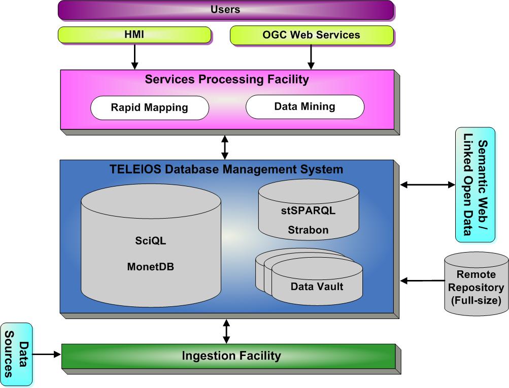
4 TELEIOS Architecture
5 Concepts and Components Query, Data Mining & Knowledge Discovery Data Sources Data Model Generation DBMS Visual Data Mining Users Interpretation & Understanding
6 Data Model Generation Data Sources Content Analysis Context Analysis EO images Image Content Query, Data Mining & Knowledge Discovery Metadata Metadata Content Context Analysis DBMS Visual Data Mining Users GIS GIS Content Metadata extraction Patch generation Feature extraction methods: Gabor filters, Weber Local descriptor, Bag of words, dictionary-based compression features, etc. Interpretation & Understanding

7 Data Model Generation: Ingested images Location of the 100 TerraSAR-X scenes and the distribution of the scenes over the World Data Model composed of: ~ patches ~320 semantic categories C.O. Dumitru and M. Datcu, Information Content of Very High Resolution SAR Images: Study of Feature Extraction and Imaging Parameters, IEEE Trans. Geoscience and Remote Sensing. To be published
 AS cnt Visual Data Mining Users FROM user_labels AS uls, user_dictionaries AS uds WHERE uls.label LIKE '%(user_label_label)s' AND uls.id=uds.")
8 Database Management System Query, Data Mining & Knowledge Discovery Strabon DBMS Data Sources Data Model Generation SQL_RETRIEVE_QUERY_BY_DICTIO NARY=""" WITH user_dict_size AS ( SELECT uls.id AS id, uls.label as label, COUNT(*) AS cnt Visual Data Mining Users FROM user_labels AS uls, user_dictionaries AS uds WHERE uls.label LIKE '%(user_label_label)s' AND uls.id=uds.user_label_id GROUP BY uls.id, uls.label ), Database scheme relation DB Some data mining functions Similarity metrics SQL functions for querying Distances Interpretation & Understanding
 AS cn FROM user_labels AS uls, user_dictionaries AS uds WHERE uls.label LIKE '%(user_label_label)s' AND uls.id=uds.user_label_id GROUP BY uls.id, uls.")
9 Database Management System Example of data model for Earth-Observation images SQL_RETRIEVE_QUERY_BY_DICTIONARY="" WITH user_dict_size AS ( SELECT uls.id AS id, uls.label as label, COUNT(*) AS cn FROM user_labels AS uls, user_dictionaries AS uds WHERE uls.label LIKE '%(user_label_label)s' AND uls.id=uds.user_label_id GROUP BY uls.id, uls.label ), inter_size AS ( -- size of dictionary intersection for all pairs of patches SELECT ud1.user_label_id AS user_label_1, ul1.label AS label_1, d2.patch_id AS patch_2, p2.label AS label_2, count(*) AS cnt_1_2 FROM. Fast Compression distance computation
10 Query, Data Mining and Knowledge Discovery Query, Data Mining & Knowledge Discovery GLCM Gabor QMF NL-STFT SVM GUI Relevance Feedback Queries: Query Builder Ontologies: Strabon SQL Query by Example Data Mining Semantic Definition Primitive Feature Extraction Blocks Semantic Class DB Data Sources Data Model Generation DBMS Visual Data Mining Users Interpretation & Understanding
11 Functional Concepts Browsing: Navigation in the archive for discovering things. The direction, and goals of the navigation are changing based on the content of the queries. It gives a global image of the archive content. Searching: Navigation in the archive with a clear objective, the results of each query is used for directing the navigation. Annotation: Creation of new catalogue (index) entries for the archive. The result of browsing or searching may be used to annotate the results.
12 Exploration/Query Concepts Numeric and predefined queries: classical geographic position, time, senor type, etc. The output is a list of products in the specified parameters Semantic an numeric queries: by use of supporting frames a complex question can be formalized. The output is a list of products explained by the query sentence. Image similarity queries: search of similar images with a given example. The output is a ranked list of images. KDD: interactive search supported by relevance feedback mechanisms. The output is the desired product, the related products (containing similar information), semantically explained, or new, previously unknown information. Visual Data Mining: Visual exploration of the whole archive. The output are outliers, interesting groups, associations, etc.
")
13 Agenda (2/2)
14 Semantic and numerical queries Semantic Labels: The user can enter a simple label in the form of text or select an item from the available labels in the catalogue to perform the query (as for example forest ). We observe that these labels are predefined labels previously obtained as results of the image annotation process. Query language and Ontologies: Here, the queries can be performed either using only semantics or semantics and spatial content in the form of text or numerical entries. The queries based on spatial content are performed by using the image descriptors. The query language can rely on a query template in order to avoid mistyping and helping the user. Query Builder enabling queries by using semantics, topological relations, different operators, and numerical descriptors
15 Query by Metadata and Ontologies TerraSAR-X metadata used for RDFs and Queries: XML file contains information about productcomponent, annotation, imagedata, missioninfo, acquisitioninfo, sceneinfo, etc Ontology queries Extraction of Metadata from XML annotation file
")

16 Agenda (2/2)

17 Query by Semantics Bridge Harbor River deposits Agriculture Breaking waves Forest and Water Vegetation Earth-Observation data model Urban + Water Urban type 1 Vegetation Buoy Water t1 Water and Boats Forest t1 Grassland Forest t2 Bridge t2 Water and Urban Roads Structure roof Railway Urban t2 Grassland Grassland Building shape Urban t3 Building reflection Vegetation Roads and Urban Trees and Buildings Water Channel Airport Forest Urban 4 Building Road + forest Urban t5 Roads highway Urban 6 Water t2 Channel queries SELECT label_id, name, FROM annotation a Join label l on a.label_id=l.label_id Skyscrapers Urban t7 Streets with buildings Sport fields Railway track Skyscrapers Semantic annotation of TerraSAR-X image content
 Proposed approach of Content-based image")


 ) D( x) Cerra and Datcu, 2010, A fast")

18 Query by Example Classical approach of CBIR (Smeulders, 2000) Proposed approach of Content-based image retrieval Similarity Measure Many steps and parameters to set Compare each object in the set to a query image Q and rank the results on the basis of their distance from Q. Fast Compression Distance FCD( x, y) = D( x) ( D( x), D( y) ) D( x) Cerra and Datcu, 2010, A fast compression-based similarity measure with applications to content-based image retrieval, Journal of Visual Communication and Image Representation, vol. 23, no. 2, pp , 2012
 AS cnt FROM user_labels AS uls, user_dictionaries AS uds WHERE uls.label LIKE '%(user_label_label)s' AND uls.id=uds.")
19 Query by example The implementation: SQL_RETRIEVE_QUERY_BY_USER_LABEL=""" WITH Y = Image dataset Offline dictionary extraction Pre-processing - Convert to HSV space, to string Dictionary Database user_dict_size AS ( SELECT uls.id AS id, uls.label as label, COUNT(*) AS cnt FROM user_labels AS uls, user_dictionaries AS uds WHERE uls.label LIKE '%(user_label_label)s' AND uls.id=uds.user_label_id GROUP BY uls.id, uls.label ), inter_size AS ( Compute distances FCD(x,Y) D( x) FCD( x, y) = D( x) ( D( x), D( y) ) -- size of dictionary intersection for all pairs of patches SELECT FROM ud1.user_label_id AS user_label_1,. Extract dictionary D(x) Rank according similarity x = Query image To present the retrieved images 19


20 Query, Data Mining and Knowledge Discovery Query, Data Mining & Knowledge Discovery GLCM Gabor QMF NL-STFT SVM GUI Relevance Feedback Queries: Query Builder Ontologies: Strabon SQL Query by Example Data Mining Semantic Definition Primitive Feature Extraction Blocks Semantic Class DB Data Sources Data Model Generation DBMS Visual Data Mining Users Interpretation & Understanding


,")
, patch")
21 Semantic annotation Methodology: PF algorithm Classification SVM with RF Annotated category Semantic Patches Collections Ground truth Optimal parameters: product type (MGD), mode (High resolution Spotlight), geometric resolution configurations (RE), patch size (160 x 160 pixels); PF algorithm (Gabor filters)


22 KDD, Active Learning and Auto-annotation KDD: interactive search supported by relevance feedback mechanisms. The output is the desired product, the related products (containing similar information), semantically explained, or new, previously unknown information learn the targeted image Query image category as accurately and as exhaustively as possible minimize the number of iterations in the relevance feedback loop sys user

23 Warning: not all categories can be learned!
 Dec.")
24 Agenda (2/2) Dec.


25 Interpretation and Understanding Query, Data Mining & Knowledge Discovery Data Sources Data Model Generation DBMS Visual Data Mining Users Rapid Mapping generation
26 Functions 1 Exploration & browsing: fast and controlled by Relevance Feedback 2 Search: fast reaching the target 3 Category learning, image grouping and annotation: fast and well controlled by Relevance Feedback and Active Learning

27 Interpretation and Understanding Semantic classes Image patches Image visualization


28 Damage Assessment using TerraSAR-X images Bridges before Tsunami Bridges after Tsunami Debris caused by Tsunami after 0 before Flooded areas Agriculture Ocean Bridges after Bridges before Flooded areas High voltage poles Flooded areas Mountains Ocean Flooded areas Structures Changes Debris


29 Visual Data Mining Query, Data Mining & Knowledge Discovery Representation of the data in the 3D space using a Laplacian eigenmap Data Sources Data Model Generation DBMS Visual Data Mining Users Interpretation and Understanding
30 Visual Data Mining Interactive exploration and analysis of very large, high complexity, and non-visual data sets. The analyst can navigate in a multi-modal space and interactively search and refine relevance criteria to explore patterns of interest in the data, and perform their in-depth analysis. Provides example views (projections) of the entire archive

31 Visual Data Mining Visual Data Mining Representation of the data in the 3D space using a Laplacian eigenmap Semantically consistent groupings appear inside the data

32 32 Visual Data Mining Image Archive View Ontology and Knowledge Graph Jain IEEE TRANSACTIONS ON MULTIMEDIA, VOL. 10, NO. 2, FEBRUARY 2008
33 Second Part Hands on evaluation of the system 3rd User Community Workshop Chania, June 2013 Presenter: Mihai Datcu and Daniela Espinoza Molina (DLR)
34 Outline Description of the data set Optical images TerraSAR-X images Other Instructions of how to use the system Description of main functions Organization of the work groups Practical exercises
 - Color histogram Semantic classes i.e. Forest : dense forest, sparse forest Mountains Agriculture fields Urban areas: dense u.")
35 Example I: L Aquila Type Image Quickbird over L Aquila (Italy) Number of patches 20,880 Patch size 100 Overlapping Features - Weber local d (WLD) - Color histogram Semantic classes i.e. Forest : dense forest, sparse forest Mountains Agriculture fields Urban areas: dense u.a, high buildings

36 Example II: Different type of forest Type Image Ikonos panchromatic over Germany Number of patches 58,208 Patch size Overlapping Features Semantic classes i.e. 100x100 WLD Roads Houses Agriculture Forest I Forest II Forest III Water


37 Example III: Romania Type Image Airborne Number of patches P1: 52,500 P2: 52,500 Patch size Overlapping Features Semantic classes i.e. 100x100 WLD Color histogram River Cities Agriculture, etc

38 Example IV: Tsunami Type Image Number of patches Patch size Overlapping Features Semantic classes i.e. TerraSAR-X GEC over Sendai (Japan) 41, x100 Weber local descriptor Flooding area, High buildings Mountains Ocean Residence area, etc.

39 Example IV: Medical images Type Image optical Number of patches 4,389 Patch size Overlapping Features 80x80 WLD Semantic classes i.e. Class 1 Class 2 Class 3


40 Example VI: Lucas Type Image Number of patches Patch size Overlapping Features Semantic classes i.e. In-situ photos 1600x1200 Weber Local descriptor


41 Semantic definition scenario 1. Create a new project: Select file/new and fill the required information on the dialog. Press OK and wait until the full image is loaded loading
42 Semantic definition scenario 2. Browsing the image: Explore the image content playing with the display functionalities using the mouse ( zoom in, zoom out, etc). Try to identify how many different classes can be annotated? Possible classes: mountains, cities: high buildings, residential area, ocean, flood area, etc.
43 Semantic definition scenario 3. Iterative training: Start the iterative/interactive training by giving positive examples (leftclick) and negative examples (right-click) on the image content with the class that you want to define. classification Negative examples Positive examples When you are ready, press to button classification

44 Semantic definition scenario 3.1 Improve the classification: the system displays in blue the areas classified. Navigate in the image looking for false alarms or miss-classifications. Repeat this process (give more positive or negative examples) until you are satisfied with the results. First iteration You can use also these patches

45 Semantic definition scenario 3.1 Improve the classification: the system displays in blue the areas classified. Navigate in the image looking for false alarms or miss-classifications. Repeat this process (give more positive or negative examples) until you are satisfied with the results. Second iteration
46 Semantic definition scenario 3.1 Improve the classification: the system displays in blue the areas classified. Navigate in the image looking for false alarms or miss-classifications. Repeat this process (give more positive or negative examples) until you are satisfied with the results. Create class Third iteration When you are ready, press to button give a name to the class

47 Semantic definition scenario 3.2 Save the class: When you press the button the system will ask you to give a name to the new class. Enter a name and then press OK. When you are ready, press to button give a name to the class
48 Semantic definition scenario 4. Visualizing the defined classes: Display the classes using the button Visualization
49 Semantic definition scenario 5. Play with the other functionalities: As for examples show the unclassified patches, etc. Don t forget to SAVE
50 Define your own classes 1. Definite semantic classes for medical image 2. Define semantic classes for L Aquila image 3. Define semantic classes for TerraSAR-X
51 Steps 1. Create a Project 2. Browse the image file 1. Zoom in, Zoom out 2. Try to identify how many different classes can be annotated? 3. Start the iterative/interactive training 1. Give good positive examples (Left-click) 2. Give negative examples (right-click) 4. Perform the classification. When the class is ok then save the new class 5. Visualize the annotated class 6. Delete the false alarms / improve your classification 7. Show the un- classified patches 8. SAVE the project.
Session 2 A virtual Observatory for TerraSAR-X data
 Session 2 A virtual Observatory for TerraSAR-X data 2nd User Community Workshop Darmstadt, 10-11 May 2012 Presenter: Mihai Datcu and Daniela Espinoza Molina (DLR) This presentation contains contributions
The Earth-Observation Image Librarian (EOLib): The data mining component of the TerraSAR-X Payload Ground Segment
: The data mining component of the TerraSAR-X Payload Ground Segment") The Earth-Observation Image Librarian (EOLib): The data mining component of the TerraSAR-X Payload Ground Segment Daniela Espinoza Molina, Vlad Manilici, Octavian Dumitru, Christoph Reck, Shiyong Cui,
The Earth-Observation Image Librarian (EOLib): The data mining component of the TerraSAR-X Payload Ground Segment Daniela Espinoza Molina, Vlad Manilici, Octavian Dumitru, Christoph Reck, Shiyong Cui,
EARTH-OBSERVATION DATA ACCESS: A KNOWLEDGE DISCOVERY CONCEPT FOR PAYLOAD GROUND SEGMENTS
 EARTH-OBSERVATION DATA ACCESS: A KNOWLEDGE DISCOVERY CONCEPT FOR PAYLOAD GROUND SEGMENTS Daniela Espinoza-Molina and Mihai Datcu German Aerospace Center, D-82234 Wessling - Germany ABSTRACT This paper
Design and Use of. Earth Observation Image Content Tools
 Design and Use of Earth Observation Image Content Tools Mihai Datcu (1, 2), Daniele Cerra (1), Houda Chaabouni-Chouayakh (1), Amaia de Miguel (1), Daniela Espinoza Molina (1), Gottfried Schwarz (1), Matteo
Image Information Mining (IIM): Where do we go?
: Where do we go?") Image Information Mining (IIM): Where do we go? Klaus Seidel and Mihai Datcu IGARSS 2004 The paradox People have normally trouble in caching more than 7 items at a time We design systems to enable people
Image Information Mining (IIM): Where do we go? Klaus Seidel and Mihai Datcu IGARSS 2004 The paradox People have normally trouble in caching more than 7 items at a time We design systems to enable people
Big, Linked and Open Earth Observation Data: the Projects TELEIOS and LEO
 Big, Linked and Open Earth Observation Data: the Projects TELEIOS and LEO Manolis Koubarakis Charalampos Nikolaou HELLENIC REPUBLIC National and Kapodistrian University of Athens Introduction TELEIOS:
KES: Knowledge Enabled Services for better EO Information Use. Andrea Colapicchioni Advanced Computer Systems Space Division
 KES: Knowledge Enabled Services for better EO Information Use Andrea Colapicchioni Advanced Computer Systems Space Division a.colapicchioni@acsys.it The problem During the last decades, the satellite image
TELEIOS FP Deliverable 3.1. KDD concepts and methods proposal: report & design recommendations
 TELEIOS FP7-257662 Deliverable 3.1 KDD concepts and methods proposal: report & design recommendations Corneliu Octavian Dumitru, Daniela Espinoza Molina, Shiyong Cui, Jagmal Singh, Marco Quartulli 1, Mihai
HIGH spatial resolution Earth Observation (EO) images
 images") JOURNAL OF L A TEX CLASS FILES, VOL. 6, NO., JANUARY 7 A Comparative Study of Bag-of-Words and Bag-of-Topics Models of EO Image Patches Reza Bahmanyar, Shiyong Cui, and Mihai Datcu, Fellow, IEEE Abstract
JOURNAL OF L A TEX CLASS FILES, VOL. 6, NO., JANUARY 7 A Comparative Study of Bag-of-Words and Bag-of-Topics Models of EO Image Patches Reza Bahmanyar, Shiyong Cui, and Mihai Datcu, Fellow, IEEE Abstract
GABOR AND WEBER FEATURE EXTRACTION PERFORMANCE BASED ON URBAN ATLAS GROUND TRUTH
 U.P.B. Sci. Bull., Series C, Vol. 78, Iss. 3, 2016 ISSN 2286-3540 GABOR AND WEBER FEATURE EXTRACTION PERFORMANCE BASED ON URBAN ATLAS GROUND TRUTH Mihaela STAN 1, Anca POPESCU 2, Dan Alexandru STOICHESCU
Strabon. Semantic support for EO Data Access in TELEIOS. Presenter: George Garbis
 Strabon Semantic support for EO Data Access in TELEIOS Presenter: George Garbis Dept. of Informatics and Telecommunications National and Kapodistrian University of Athens June 23 Florence, Italy Outline
A Content Based Image Retrieval System Based on Color Features
 A Content Based Image Retrieval System Based on Features Irena Valova, University of Rousse Angel Kanchev, Department of Computer Systems and Technologies, Rousse, Bulgaria, Irena@ecs.ru.acad.bg Boris
Building Virtual Earth Observatories Using Scientific Database, Semantic Web and Linked Geospatial Data Technologies
 Building Virtual Earth Observatories Using Scientific Database, Semantic Web and Linked Geospatial Data Technologies Presenter: George Garbis ggarbis@di.uoa.gr Dept. of Informatics and Telecommunications
Contextual descriptors ad neural networks for scene analysis in VHR SAR images
 Workshop Nazionale La Missione COSMO-SkyMed: Stato dell Arte, Applicazioni e Prospettive Future Roma, 13-15 Novembre 2017 Contextual descriptors ad neural networks for scene analysis in VHR SAR images
SEXTANT 1. Purpose of the Application
 SEXTANT 1. Purpose of the Application Sextant has been used in the domains of Earth Observation and Environment by presenting its browsing and visualization capabilities using a number of link geospatial
Architecture Concept for an Information Mining System for Earth Observation Data ABSTRACT
 Architecture Concept for an Information Mining System for Earth Observation Data Vlad Manilici, Stephan Kiemle, Christoph Reck, Mario Winkler German Aerospace Centre (DLR) Münchner Straße 20, 82234 Weßling,
Earth Observation Image Semantic Bias: A Collaborative User Annotation Approach
 Earth Observation Image Semantic Bias: A Collaborative User Annotation Approach Ambar Murillo Montes de Oca, Reza Bahmanyar, Nicolae Nistor, and Mihai Datcu Fellow, IEEE Abstract Correctly annotated image
Overview of the GMES Space Component & DMC as a GMES Contributing Mission
 Overview of the GMES Space Component & DMC as a GMES Contributing Mission Eleni Paliouras GMES Space Office, Directorate of Earth Observation, ESA DMC Consortium Meeting, London 16/02/2011 ESA UNCLASSIFIED
This is the general guide for landuse mapping using mid-resolution remote sensing data
 This is the general guide for landuse mapping using mid-resolution remote sensing data February 11 2015 This document has been prepared for Training workshop on REDD+ Research Project in Peninsular Malaysia
LSGI 521: Principles of GIS. Lecture 5: Spatial Data Management in GIS. Dr. Bo Wu
 Lecture 5: Spatial Data Management in GIS Dr. Bo Wu lsbowu@polyu.edu.hk Department of Land Surveying & Geo-Informatics The Hong Kong Polytechnic University Contents 1. Learning outcomes 2. From files to
Object-oriented Classification of Urban Areas Using Lidar and Aerial Images
 Journal of the Korean Society of Surveying, Geodesy, Photogrammetry and Cartography Vol. 33, No. 3, 173-179, 2015 http://dx.doi.org/10.7848/ksgpc.2015.33.3.173 ISSN 1598-4850(Print) ISSN 2288-260X(Online)
City-Modeling. Detecting and Reconstructing Buildings from Aerial Images and LIDAR Data
 City-Modeling Detecting and Reconstructing Buildings from Aerial Images and LIDAR Data Department of Photogrammetrie Institute for Geodesy and Geoinformation Bonn 300000 inhabitants At river Rhine University
Name: Date: June 27th, 2011 GIS Boot Camps For Educators Lecture_3
 Name: Date: June 27th, 2011 GIS Boot Camps For Educators Lecture_3 Practical: Creating and Editing Shapefiles Using Straight, AutoComplete and Cut Polygon Tools Use ArcCatalog to copy data files from:
Multi-modal, multi-temporal data analysis for urban remote sensing
 Multi-modal, multi-temporal data analysis for urban remote sensing Xiaoxiang Zhu www.sipeo.bgu.tum.de 10.10.2017 Uncontrolled Growth in Mumbai Slums Leads to Massive Fires and Floods So2Sat: Big Data for
Bus Detection and recognition for visually impaired people
 Bus Detection and recognition for visually impaired people Hangrong Pan, Chucai Yi, and Yingli Tian The City College of New York The Graduate Center The City University of New York MAP4VIP Outline Motivation
IMAGINE Objective. The Future of Feature Extraction, Update & Change Mapping
 IMAGINE ive The Future of Feature Extraction, Update & Change Mapping IMAGINE ive provides object based multi-scale image classification and feature extraction capabilities to reliably build and maintain
DSM GENERATION FROM STEREOSCOPIC IMAGERY FOR DAMAGE MAPPING, APPLICATION ON THE TOHOKU TSUNAMI
 DSM GENERATION FROM STEREOSCOPIC IMAGERY FOR DAMAGE MAPPING, APPLICATION ON THE TOHOKU TSUNAMI Cyrielle Guérin, Renaud Binet, Marc Pierrot-Deseilligny To cite this version: Cyrielle Guérin, Renaud Binet,
Explore some of the new functionality in ArcMap 10
 Explore some of the new functionality in ArcMap 10 Scenario In this exercise, imagine you are a GIS analyst working for Old Dominion University. Construction will begin shortly on renovation of the new
Urban Scene Segmentation, Recognition and Remodeling. Part III. Jinglu Wang 11/24/2016 ACCV 2016 TUTORIAL
 Part III Jinglu Wang Urban Scene Segmentation, Recognition and Remodeling 102 Outline Introduction Related work Approaches Conclusion and future work o o - - ) 11/7/16 103 Introduction Motivation Motivation
ENVI Automated Image Registration Solutions
 ENVI Automated Image Registration Solutions Xiaoying Jin Harris Corporation Table of Contents Introduction... 3 Overview... 4 Image Registration Engine... 6 Image Registration Workflow... 8 Technical Guide...
COMBINING HIGH SPATIAL RESOLUTION OPTICAL AND LIDAR DATA FOR OBJECT-BASED IMAGE CLASSIFICATION
 COMBINING HIGH SPATIAL RESOLUTION OPTICAL AND LIDAR DATA FOR OBJECT-BASED IMAGE CLASSIFICATION Ruonan Li 1, Tianyi Zhang 1, Ruozheng Geng 1, Leiguang Wang 2, * 1 School of Forestry, Southwest Forestry
GIS Basics for Urban Studies
 GIS Basics for Urban Studies Date: March 21, 2018 Contacts: Mehdi Aminipouri, Graduate Peer GIS Faciliator, SFU Library (maminipo@sfu.ca) Keshav Mukunda, GIS & Map Librarian Librarian for Geography (kmukunda@sfu.ca)
Parameter Free Image Artifacts Detection: A Compression Based Approach
 Parameter Free Image Artifacts Detection: A Compression Based Approach Avid Roman-Gonzalez a*, Mihai Datcu b a TELECOM ParisTech, 75013 Paris, France b German Aerospace Center (DLR), Oberpfaffenhofen ABSTRACT
Data: a collection of numbers or facts that require further processing before they are meaningful
 Digital Image Classification Data vs. Information Data: a collection of numbers or facts that require further processing before they are meaningful Information: Derived knowledge from raw data. Something
(Refer Slide Time: 0:51)
") Introduction to Remote Sensing Dr. Arun K Saraf Department of Earth Sciences Indian Institute of Technology Roorkee Lecture 16 Image Classification Techniques Hello everyone welcome to 16th lecture in
Introduction to Remote Sensing Dr. Arun K Saraf Department of Earth Sciences Indian Institute of Technology Roorkee Lecture 16 Image Classification Techniques Hello everyone welcome to 16th lecture in
Toward Retail Product Recognition on Grocery Shelves
 Toward Retail Product Recognition on Grocery Shelves Gül Varol gul.varol@boun.edu.tr Boğaziçi University, İstanbul, Turkey İdea Teknoloji Çözümleri, İstanbul, Turkey Rıdvan S. Kuzu ridvan.salih@boun.edu.tr
The Stanford/Technicolor/Fraunhofer HHI Video Semantic Indexing System
 The Stanford/Technicolor/Fraunhofer HHI Video Semantic Indexing System Our first participation on the TRECVID workshop A. F. de Araujo 1, F. Silveira 2, H. Lakshman 3, J. Zepeda 2, A. Sheth 2, P. Perez
Files Used in this Tutorial
 Generate Point Clouds and DSM Tutorial This tutorial shows how to generate point clouds and a digital surface model (DSM) from IKONOS satellite stereo imagery. You will view the resulting point clouds
BUILT-UP AREAS MAPPING AT GLOBAL SCALE BASED ON ADAPATIVE PARAMETRIC THRESHOLDING OF SENTINEL-1 INTENSITY & COHERENCE TIME SERIES
 BUILT-UP AREAS MAPPING AT GLOBAL SCALE BASED ON ADAPATIVE PARAMETRIC THRESHOLDING OF SENTINEL-1 INTENSITY & COHERENCE TIME SERIES M. Chini, R. Pelich, R. Hostache, P. Matgen MultiTemp 2017 June 27-29,
Lidar Working with LAS Datasets
 2013 Esri International User Conference July 8 12, 2013 San Diego, California Technical Workshop Lidar Working with LAS Datasets Raghav Vemula (3D Team) Esri UC2013. Technical Workshop. Agenda Las Dataset
CROP MAPPING WITH SENTINEL-2 JULY 2017, SPAIN
 _p TRAINING KIT LAND01 CROP MAPPING WITH SENTINEL-2 JULY 2017, SPAIN Table of Contents 1 Introduction to RUS... 3 2 Crop mapping background... 3 3 Training... 3 3.1 Data used... 3 3.2 Software in RUS environment...
Rough Feature Selection for CBIR. Outline
 Rough Feature Selection for CBIR Instructor:Dr. Wojciech Ziarko presenter :Aifen Ye 19th Nov., 2008 Outline Motivation Rough Feature Selection Image Retrieval Image Retrieval with Rough Feature Selection
Presented by Kit Na Goh
 Developing A Geo-Spatial Search Tool Using A Relational Database Implementation of the FGDC CSDGM Model Presented by Kit Na Goh Introduction Executive Order 12906 was issued on April 13, 1994 with the
TELEIOS 3rd User Community Workshop
 TELEIOS 3rd User Community Workshop Wrap-up Manolis Koubarakis National and Kapodistrian University of Athens Wrap-up Session (Friday) Wrap-up of the individual sessions (done already) Brainstorming Session
Content Based Image Retrieval Using Color Quantizes, EDBTC and LBP Features
 Content Based Image Retrieval Using Color Quantizes, EDBTC and LBP Features 1 Kum Sharanamma, 2 Krishnapriya Sharma 1,2 SIR MVIT Abstract- To describe the image features the Local binary pattern (LBP)
Introduction to Prod-Trees
 European Geosciences Union General Assembly 2014 Prod Trees Bernard Valentin Vienna Austria 29 April 2014 Outline 2 Background Prod-Trees Project RARE Project and Platform Status Future Background (ESA)
Presented at the FIG Congress 2018, May 6-11, 2018 in Istanbul, Turkey
 Presented at the FIG Congress 2018, May 6-11, 2018 in Istanbul, Turkey Evangelos MALTEZOS, Charalabos IOANNIDIS, Anastasios DOULAMIS and Nikolaos DOULAMIS Laboratory of Photogrammetry, School of Rural
Unsupervised Change Detection in Optical Satellite Images using Binary Descriptor
 Unsupervised Change Detection in Optical Satellite Images using Binary Descriptor Neha Gupta, Gargi V. Pillai, Samit Ari Department of Electronics and Communication Engineering, National Institute of Technology,
Lecturer 2: Spatial Concepts and Data Models
 Lecturer 2: Spatial Concepts and Data Models 2.1 Introduction 2.2 Models of Spatial Information 2.3 Three-Step Database Design 2.4 Extending ER with Spatial Concepts 2.5 Summary Learning Objectives Learning
What s New in ecognition 9.0. Christian Weise
 What s New in ecognition 9.0 Christian Weise Presenting ecognition 9 Release Date: March 2014 Who s eligible? All user with a valid ecognition maintenance contract Presenting ecognition 9 ecognition version
From Multi-sensor Data to 3D Reconstruction of Earth Surface: Innovative, Powerful Methods for Geoscience and Other Applications
 From Multi-sensor Data to 3D Reconstruction of Earth Surface: Innovative, Powerful Methods for Geoscience and Other Applications Bea Csatho, Toni Schenk*, Taehun Yoon* and Michael Sheridan, Department
Content Based Image Retrieval
 Content Based Image Retrieval R. Venkatesh Babu Outline What is CBIR Approaches Features for content based image retrieval Global Local Hybrid Similarity measure Trtaditional Image Retrieval Traditional
Figure 1: Workflow of object-based classification
 Technical Specifications Object Analyst Object Analyst is an add-on package for Geomatica that provides tools for segmentation, classification, and feature extraction. Object Analyst includes an all-in-one
Hybrid Model with Super Resolution and Decision Boundary Feature Extraction and Rule based Classification of High Resolution Data
 Hybrid Model with Super Resolution and Decision Boundary Feature Extraction and Rule based Classification of High Resolution Data Navjeet Kaur M.Tech Research Scholar Sri Guru Granth Sahib World University
Introduction to Geodatabase and Spatial Management in ArcGIS. Craig Gillgrass Esri
 Introduction to Geodatabase and Spatial Management in ArcGIS Craig Gillgrass Esri Session Path The Geodatabase - What is it? - Why use it? - What types are there? - What can I do with it? Query Layers
Transformative characteristics and research agenda for the SDI-SKI step change: A Cadastral Case Study
 Transformative characteristics and research agenda for the SDI-SKI step change: A Cadastral Case Study Dr Lesley Arnold Research Fellow, Curtin University, CRCSI Director Geospatial Frameworks World Bank
Multimodal Information Spaces for Content-based Image Retrieval
 Research Proposal Multimodal Information Spaces for Content-based Image Retrieval Abstract Currently, image retrieval by content is a research problem of great interest in academia and the industry, due
AUTOMATIC INTERPRETATION OF HIGH RESOLUTION SAR IMAGES: FIRST RESULTS OF SAR IMAGE SIMULATION FOR SINGLE BUILDINGS
 AUTOMATIC INTERPRETATION OF HIGH RESOLUTION SAR IMAGES: FIRST RESULTS OF SAR IMAGE SIMULATION FOR SINGLE BUILDINGS J. Tao *, G. Palubinskas, P. Reinartz German Aerospace Center DLR, 82234 Oberpfaffenhofen,
Exercise 1: Introduction to ILWIS with the Riskcity dataset
 Exercise 1: Introduction to ILWIS with the Riskcity dataset Expected time: 2.5 hour Data: data from subdirectory: CENN_DVD\ILWIS_ExerciseData\IntroRiskCity Objectives: After this exercise you will be able
Step by Step GIS. Section 1
 Step by Step GIS Section 1 Contact the web page given below for the data required to do the exercises (http://www.pasda.psu.edu/default.asp) Before beginning the tutorials please visit the Preparation
Matthew Heric, Geoscientist and Kevin D. Potter, Product Manager. Autometric, Incorporated 5301 Shawnee Road Alexandria, Virginia USA
 INTEGRATIONS OF STRUCTURED QUERY LANGUAGE WITH GEOGRAPHIC INFORMATION SYSTEM PROCESSING: GeoServer Matthew Heric, Geoscientist and Kevin D. Potter, Product Manager Autometric, Incorporated 5301 Shawnee
Hands on Exercise Using ecognition Developer
 1 Hands on Exercise Using ecognition Developer 2 Hands on Exercise Using ecognition Developer Hands on Exercise Using ecognition Developer Go the Windows Start menu and Click Start > All Programs> ecognition
GEOBIA for ArcGIS (presentation) Jacek Urbanski
 Jacek Urbanski") GEOBIA for ArcGIS (presentation) Jacek Urbanski INTEGRATION OF GEOBIA WITH GIS FOR SEMI-AUTOMATIC LAND COVER MAPPING FROM LANDSAT 8 IMAGERY Presented at 5th GEOBIA conference 21 24 May in Thessaloniki.
GEOBIA for ArcGIS (presentation) Jacek Urbanski INTEGRATION OF GEOBIA WITH GIS FOR SEMI-AUTOMATIC LAND COVER MAPPING FROM LANDSAT 8 IMAGERY Presented at 5th GEOBIA conference 21 24 May in Thessaloniki.
VEHICLE QUEUE DETECTION IN SATELLITE IMAGES OF URBAN AREAS
 VEHICLE QUEUE DETECTION IN SATELLITE IMAGES OF URBAN AREAS J. Leitloff 1, S. Hinz 2, U. Stilla 1 1 Photogrammetry and Remote Sensing, 2 Remote Sensing Technology Technische Universitaet Muenchen, Arcisstrasse
Introduction to the Google Earth Engine Workshop
 Introduction to the Google Earth Engine Workshop This workshop will introduce the user to the Graphical User Interface (GUI) version of the Google Earth Engine. It assumes the user has a basic understanding
Image Processing (IP)
") Image Processing Pattern Recognition Computer Vision Xiaojun Qi Utah State University Image Processing (IP) Manipulate and analyze digital images (pictorial information) by computer. Applications: The
Image Processing Pattern Recognition Computer Vision Xiaojun Qi Utah State University Image Processing (IP) Manipulate and analyze digital images (pictorial information) by computer. Applications: The
IMPROVING 2D CHANGE DETECTION BY USING AVAILABLE 3D DATA
 IMPROVING 2D CHANGE DETECTION BY USING AVAILABLE 3D DATA C.J. van der Sande a, *, M. Zanoni b, B.G.H. Gorte a a Optical and Laser Remote Sensing, Department of Earth Observation and Space systems, Delft
An Introduction to Using Lidar with ArcGIS and 3D Analyst
 FedGIS Conference February 24 25, 2016 Washington, DC An Introduction to Using Lidar with ArcGIS and 3D Analyst Jim Michel Outline Lidar Intro Lidar Management Las files Laz, zlas, conversion tools Las
CHAPTER 5 OBJECT ORIENTED IMAGE ANALYSIS
 85 CHAPTER 5 OBJECT ORIENTED IMAGE ANALYSIS 5.1 GENERAL Urban feature mapping is one of the important component for the planning, managing and monitoring the rapid urbanized growth. The present conventional
ISSN: , (2015): DOI:
: DOI:") www.ijecs.in International Journal Of Engineering And Computer Science ISSN:2319-7242 Volume 6 Issue 6 June 2017, Page No. 21737-21742 Index Copernicus value (2015): 58.10 DOI: 10.18535/ijecs/v6i6.31 A
www.ijecs.in International Journal Of Engineering And Computer Science ISSN:2319-7242 Volume 6 Issue 6 June 2017, Page No. 21737-21742 Index Copernicus value (2015): 58.10 DOI: 10.18535/ijecs/v6i6.31 A
EVALUATION OF WORLDVIEW-1 STEREO SCENES AND RELATED 3D PRODUCTS
 EVALUATION OF WORLDVIEW-1 STEREO SCENES AND RELATED 3D PRODUCTS Daniela POLI, Kirsten WOLFF, Armin GRUEN Swiss Federal Institute of Technology Institute of Geodesy and Photogrammetry Wolfgang-Pauli-Strasse
Calculation of beta naught and sigma naught for TerraSAR-X data
 Calculation of beta naught and sigma naught for TerraSAR-X data 1 Introduction The present document describes the successive steps of the TerraSAR-X data absolute calibration. Absolute calibration allows
Image Classification. Introduction to Photogrammetry and Remote Sensing (SGHG 1473) Dr. Muhammad Zulkarnain Abdul Rahman
 Dr. Muhammad Zulkarnain Abdul Rahman") Image Classification Introduction to Photogrammetry and Remote Sensing (SGHG 1473) Dr. Muhammad Zulkarnain Abdul Rahman Classification Multispectral classification may be performed using a variety of methods,
Image Classification Introduction to Photogrammetry and Remote Sensing (SGHG 1473) Dr. Muhammad Zulkarnain Abdul Rahman Classification Multispectral classification may be performed using a variety of methods,
Aardobservatie en Data-analyse Image processing
 Aardobservatie en Data-analyse Image processing 1 Image processing: Processing of digital images aiming at: - image correction (geometry, dropped lines, etc) - image calibration: DN into radiance or into
DATA FUSION AND INTEGRATION FOR MULTI-RESOLUTION ONLINE 3D ENVIRONMENTAL MONITORING
 DATA FUSION AND INTEGRATION FOR MULTI-RESOLUTION ONLINE 3D ENVIRONMENTAL MONITORING Yun Zhang, Pingping Xie, Hui Li Department of Geodesy and Geomatics Engineering, University of New Brunswick Fredericton,
Greece s Collaborative Ground Segment Initiatives
 Greece s Collaborative Ground Segment Initiatives Dr Haris KONTOES National Observatory of Athens SENTINEL COLLABORATIVE GS WORKSHOP 2015, 28 May 2015 Matera Collaborative GS workshop 2015 27 28 May 2015
NATIONWIDE POINT CLOUDS AND 3D GEO- INFORMATION: CREATION AND MAINTENANCE GEORGE VOSSELMAN
 NATIONWIDE POINT CLOUDS AND 3D GEO- INFORMATION: CREATION AND MAINTENANCE GEORGE VOSSELMAN OVERVIEW National point clouds Airborne laser scanning in the Netherlands Quality control Developments in lidar
Transformative characteristics and research agenda for the SDI-SKI step change:
 Transformative characteristics and research agenda for the SDI-SKI step change: A Cadastral Case Study Dr Lesley Arnold Research Fellow, Curtin University, CRCSI Director Geospatial Frameworks World Bank
Lab 6: Transforming Spatial Data
 Lab 6: Transforming Spatial Data Objectives: The primary objectives of this lab are to georeference a raster dataset and to create GIS data by digitizing features from an image as a backdrop. Specifics:
Lab 1: Exploring ArcMap and ArcCatalog In this lab, you will explore the ArcGIS applications ArcCatalog and ArcMap. You will learn how to use
 Lab 1: Exploring ArcMap and ArcCatalog In this lab, you will explore the ArcGIS applications ArcCatalog and ArcMap. You will learn how to use ArcCatalog to find maps and data and how to display maps in
Tri-modal Human Body Segmentation
 Tri-modal Human Body Segmentation Master of Science Thesis Cristina Palmero Cantariño Advisor: Sergio Escalera Guerrero February 6, 2014 Outline 1 Introduction 2 Tri-modal dataset 3 Proposed baseline 4
A Study on Low Level Features and High
 A Study on Low Level Features and High Level Features in CBIR Rohini Goyenka 1, D.B.Kshirsagar 2 P.G. Student, Department of Computer Engineering, SRES Engineering College, Kopergaon, Maharashtra, India
Holistic Correlation of Color Models, Color Features and Distance Metrics on Content-Based Image Retrieval
 Holistic Correlation of Color Models, Color Features and Distance Metrics on Content-Based Image Retrieval Swapnil Saurav 1, Prajakta Belsare 2, Siddhartha Sarkar 3 1Researcher, Abhidheya Labs and Knowledge
Exelis Visual Information Solutions Capability Overview Presented to NetHope October 8, Brian Farr Academic & NGO Program Manager
 Exelis Visual Information Solutions Capability Overview Presented to NetHope October 8, 2013 Brian Farr Academic & NGO Program Manager Agenda Overview of ENVI Platform ENVI+IDL ENVI EX ENVI LiDAR Integration
Compression of RADARSAT Data with Block Adaptive Wavelets Abstract: 1. Introduction
 Compression of RADARSAT Data with Block Adaptive Wavelets Ian Cumming and Jing Wang Department of Electrical and Computer Engineering The University of British Columbia 2356 Main Mall, Vancouver, BC, Canada
Remote Sensed Image Classification based on Spatial and Spectral Features using SVM
 RESEARCH ARTICLE OPEN ACCESS Remote Sensed Image Classification based on Spatial and Spectral Features using SVM Mary Jasmine. E PG Scholar Department of Computer Science and Engineering, University College
Extraction of cross-sea bridges from GF-2 PMS satellite images using mathematical morphology
 IOP Conference Series: Earth and Environmental Science PAPER OPEN ACCESS Extraction of cross-sea bridges from GF-2 PMS satellite images using mathematical morphology To cite this article: Chao Chen et
METRIC AND QUALITATIVE EVALUATION OF QUICKBIRD ORTHOIMAGES FOR A LARGE SCALE GEODATABASE CREATION
 METRIC AND QUALITATIVE EVALUATION OF QUICKBIRD ORTHOIMAGES FOR A LARGE SCALE GEODATABASE CREATION Maurizio Barbarella, Michela Zanni DISTART Università di Bologna maurizio.barbarella@mail.ing.unibo.it,
Deep Learning for Remote Sensing
 1 ENPC Data Science Week Deep Learning for Remote Sensing Alexandre Boulch 2 ONERA Research, Innovation, expertise and long-term vision for industry, French government and Europe 3 Materials Optics Aerodynamics
Streamlining Editing Workflows. Amber Bethell
 Streamlining Editing Workflows Amber Bethell Workflow for solving geographic problems Ask a question Create or acquire data Validate and update data Analyze data Create cartographic product Act upon knowledge
Lab 3: Digitizing in ArcGIS Pro
 Lab 3: Digitizing in ArcGIS Pro What You ll Learn: In this Lab you ll be introduced to basic digitizing techniques using ArcGIS Pro. You should read Chapter 4 in the GIS Fundamentals textbook before starting
What s New in ecognition 9.0
 What s New in ecognition 9.0 Dr. Waldemar Krebs tranforming data into GIS ready information Trends in Earth Observation Increasing need for detailed, up-to-date information as a basis for planning and
Reducing Consumer Uncertainty
 Spatial Analytics Reducing Consumer Uncertainty Towards an Ontology for Geospatial User-centric Metadata Introduction Cooperative Research Centre for Spatial Information (CRCSI) in Australia Communicate
Answer the following general questions: 1. What happens when you right click on an icon on your desktop? When you left double click on an icon?
 Name: Date: June 27th, 2011 GIS Boot Camps For Educators Practical: Explore ArcGIS 10 Desktop Tools and functionality Day_1 Lecture 1 Sources: o ArcGIS Desktop help o ESRI website o Getting to Know ArcGIS
Prof. Jose L. Flores, MS, PS Dept. of Civil Engineering & Surveying
 Prof. Jose L. Flores, MS, PS Dept. of Civil Engineering & Surveying Problem One of the challenges for any Geographic Information System (GIS) application is to keep the spatial data up to date and accurate.
<is web> Information Systems & Semantic Web University of Koblenz Landau, Germany
 Information Systems & University of Koblenz Landau, Germany Semantic Search examples: Swoogle and Watson Steffen Staad credit: Tim Finin (swoogle), Mathieu d Aquin (watson) and their groups 2009-07-17
Enterprise Data Catalog for Microsoft Azure Tutorial
 Enterprise Data Catalog for Microsoft Azure Tutorial VERSION 10.2 JANUARY 2018 Page 1 of 45 Contents Tutorial Objectives... 4 Enterprise Data Catalog Overview... 5 Overview... 5 Objectives... 5 Enterprise
SENTINEL-2 PROCESSING IN SNAP
 SENTINEL-2 PROCESSING IN SNAP EXERCISE 1 (exploring S2 data) Data: Sentinel-2A Level 1C: S2A_MSIL1C_20170316T094021_N0204_R036_T33SVB_20170316T094506.SAFE 1. Open file 1.1. File / Open Product 1.2. Browse
arxiv: v4 [cs.cv] 6 Feb 2017
![arxiv: v4 [cs.cv] 6 Feb 2017](/thumbs/75/72209328.jpg "arxiv: v4 [cs.cv] 6 Feb 2017") Visual descriptors for content-based retrieval of remote sensing images Paolo Napoletano Department of Informatics, Systems and Communication. University of Milano - Bicocca. Viale Sarca 336/U14. 20126
Visual descriptors for content-based retrieval of remote sensing images Paolo Napoletano Department of Informatics, Systems and Communication. University of Milano - Bicocca. Viale Sarca 336/U14. 20126
Columbia University High-Level Feature Detection: Parts-based Concept Detectors
 TRECVID 2005 Workshop Columbia University High-Level Feature Detection: Parts-based Concept Detectors Dong-Qing Zhang, Shih-Fu Chang, Winston Hsu, Lexin Xie, Eric Zavesky Digital Video and Multimedia Lab