Ambiguities in the Implementation of the INSPIRE directive for Metadata. J.Walther, F.Schenk
|
|
|
- Dorthy Byrd
- 5 years ago
- Views:
Transcription
1 Ambiguities in the Implementation of the INSPIRE directive for Metadata J.Walther, F.Schenk
2 Errors and Ambiguities e.g. UseLimitation INSPIRE Metadata Implementing Rules: Technical Guidelines based on EN ISO and EN ISO 19119: restrictions on the access and use of a resource or metadata ISO 19115: limitation affecting the fitness for use of the resource or metadata. Example, not to be used for navigation more suitable: useconstraints constraints applied to assure the protection of privacy or intellectual property, and any special restrictions or limitations or warnings on using the resource or metadata
3 INSPIRE and Metadata Foundations Implementing Directive 2007/2/EC INSPIRE Metadata Implementing Rules: Technical Guidelines based on EN ISO and EN ISO 19119
4 INSPIRE and Metadata Principles 1. finding data / services: discovery services 2. using data requires finding services (download or view services)
5 Typical SDI Topology decentralised discovery infrastructure limited (thematic) coverage of individual discovery services (e.g. federal states, nation, themes) duplication (harvesting) of metadata
6 INSPIRE Portal Geodatenkatalog.de catalogues of fed. government department-specific catalogues catalogues of federal states further catalogues department-specific catalogues communal catalogues further catalogues
7 Use case 1: use discovery service to find relevant data select data find appropriate (coupled) view service visualize data
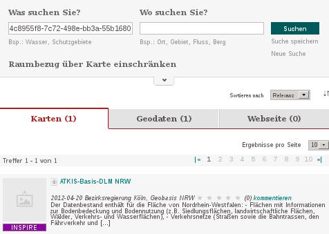
8 Dataset: ATKIS-Basis-DLM NRW
9 Service:
10 <gmd:md_identifier> <gmd:code> <gco:characterstring> </gco:characterstring> </gmd:code> </gmd:md_identifier> Dataset Metadata Resource Identifier Service Metadata <srv:operateson uuidref=" xlink:href=
11 Legal Background Metadata implementing directive

12 Background - TG
13 <gmd:md_identifier> <gmd:code> <gco:characterstring> </gco:characterstring> </gmd:code> </gmd:md_identifier> CSW-Queryable operateson Service Metadata operateson DENWAT01 <gmd:rs_identifier> <gmd:code> <gco:characterstring> DENWAT01 </gco:characterstring> </gmd:code> <gmd:codespace> <gco:characterstring> </gco:characterstring> </gmd:codespace> </gmd:rs_identifier>
14 Use case 2: use discovery service to find relevant view services the service operates on one or more datasets: find the descriptions of those datasets
15 URL vs URI: Two Different Interpretations <srv:operateson uuidref=" xlink:href= Service Metadata URL? URI?
16 iso / gmd schema (xlink:href -> xsd:anyuri) The type xsd:anyuri represents a Uniform Resource Identifier (URI) reference. [...] URIs are not required to be dereferencable; that is, it is not necessary for there to be a web page at in order for this to be a valid URI. xlink-specification The value of the href attribute must be a URI reference as defined in [IETF RFC 2396], or must result in a URI reference after the escaping procedure described below is applied. The procedure is applied when passing the URI reference to a URI resolver.
17 dereferenceable URIs are cool...but not always present... only useful in stable environments (e.g. if registries are already available)
18 URL vs URI: Two Different Interpretations <srv:operateson uuidref=" xlink:href= URL Service Metadata URI Discovery Service Dataset Metadata Dataset Metadata
19 Interoperability needs the cosideration of different variants in Workflows / SDIs Validation services Use registries, as soon as they are available!
8 Dataset-level metadata
 8 Dataset-level metadata This section specifies dataset-level metadata elements, which should be used for documenting metadata for a complete dataset or dataset series. NOTE Metadata can also be reported
Approach to persistent identifiers and data-service-coupling in the German Spatial Data Infrastructure
 Approach to persistent identifiers and data-service-coupling in the German Spatial Data Infrastructure Martin Seiler 1, Marcus Walther 2, Jürgen Walther 2 1 Coordination Office Spatial Data Infrastructre;
Validation experience
 Validation experience Paloma Abad Head of SDI Department SDI Workshop 26-06-2018 INSPIRE KEN INSPIRE KEN, june 2018 1 Points 1. Introduction 2. Interoperability 3. Geoportal Thematic Viewer 4. Conclusions
Initial Operating Capability & The INSPIRE Community Geoportal
 INSPIRE Conference, Rotterdam, 15 19 June 2009 1 Infrastructure for Spatial Information in the European Community Initial Operating Capability & The INSPIRE Community Geoportal EC INSPIRE GEOPORTAL TEAM
The Scottish Spatial Data Infrastructure (SSDI)
") The Scottish Spatial Data Infrastructure (SSDI) INSPIRE Conference Istanbul Monday 25 th June 2012 15:55 Geoportals and registries II Tim Duffy BGS Edinburgh (trd@bgs.ac.uk) Shona Nicol Alex Ramage NERC
The Scottish Spatial Data Infrastructure (SSDI) INSPIRE Conference Istanbul Monday 25 th June 2012 15:55 Geoportals and registries II Tim Duffy BGS Edinburgh (trd@bgs.ac.uk) Shona Nicol Alex Ramage NERC
GeoDCAT-AP Representing geographic metadata by using the "DCAT application profile for data portals in Europe"
 GeoDCAT-AP Representing geographic metadata by using the "DCAT application profile for data portals in Europe" Andrea Perego, Vlado Cetl, Anders Friis-Christensen, Michael Lutz, Lorena Hernandez Joint
INSPIRE Infrastructure for Spatial Information in Europe
 INSPIRE Infrastructure for Spatial Information in Europe INSPIRE Domain Model Title Creator INSPIRE Domain Model IOC Services Team Date 23-03-2010 Subject Status Publisher Type Description Format Source
Introduction to INSPIRE. Network Services
 Introduction to INSPIRE. Network Services European Commission Joint Research Centre Institute for Environment and Sustainability Digital Earth and Reference Data Unit www.jrc.ec.europa.eu Serving society
The French Geoportal : linking discovery and view network services. INSPIRE Conference Krakow
 The French Geoportal : linking discovery and view network services ( BRGM ) D.Richard (IGN) F. Robida Context of the French Geoportal The governance mechanism Transversal organisation based on the Ministry
Harvesting Open Government Data with DCAT-AP
 Fraunhofer FOKUS Institute for Open Communication Systems AlanDavidRobb / Pixabay (CC0) Harvesting Open Government Data with DCAT-AP Fabian Kirstein, 21. March 2018 The European Data Portal offers more
Integrating the UK Location Information Infrastructure and data.gov.uk
 Integrating the UK Location Information Infrastructure and data.gov.uk Rod Kedge - UK Location Programme 1 July 20011 This presentation The issue: How to derive the benefits of INSPIRE Background UKLII
The European Commission s science and knowledge service. Joint Research Centre
 The European Commission s science and knowledge service Joint Research Centre GeoDCAT-AP The story so far Andrea Perego, Antonio Rotundo, Lieven Raes GeoDCAT-AP Webinar 6 June 2018 What is GeoDCAT-AP Geospatial
Daniela Cristiana Docan I 6th Sept. I INSPIRE Conference 2017, Strasbourg. EEA Data Quality Management supporting INSPIRE implementation
 Daniela Cristiana Docan I 6th Sept. I INSPIRE Conference 2017, Strasbourg EEA Data Quality Management supporting INSPIRE implementation Data Quality in INSPIRE INSPIRE Technical Guidelines use ISO 19157
INSPIRE & Environment Data in the EU
 INSPIRE & Environment Data in the EU Andrea Perego Research Data infrastructures for Environmental related Societal Challenges Workshop @ pre-rda P6 Workshops, Paris 22 September 2015 INSPIRE in a nutshell
Experience federating the metadata catalogue of IGN in the Spanish Open Data Portal
 Experience federating the metadata catalogue of IGN in the Spanish Open Data Portal Paloma Abad E. López, A.F. Rodríguez, A. Sánchez, S. Castro, S. Soriano, J.I Sánchez 1 Summary IGN Metadata Catalogue
MIWP-8: Metadata - Task #2221 MIWP-8 (M) Coupled resource
 Coupled resource") MIWP-8: Metadata - Task #2221 MIWP-8 (M) Coupled resource 17 Sep 2014 09:02 am - Michael Östling Status: Closed Start date: 17 Sep 2014 Priority: Normal Due date: Assignee: % Done: 0% Category: Estimated
MIWP-8: Metadata - Task #2221 MIWP-8 (M) Coupled resource 17 Sep 2014 09:02 am - Michael Östling Status: Closed Start date: 17 Sep 2014 Priority: Normal Due date: Assignee: % Done: 0% Category: Estimated
Spatial Data on the Web
 Spatial Data on the Web Tools and guidance for data providers The European Commission s science and knowledge service W3C Data on the Web Best Practices 35 W3C/OGC Spatial Data on the Web Best Practices
IR on metadata Change proposal(s) on the Resource Locator element
 on the Resource Locator element") INSPIRE Infrastructure for Spatial Information in Europe IR on metadata Change proposal(s) on the Resource Locator element Type Creator Document for information and discussion CZ, DE, DK, FR, NL, ENV Date/status/version
INSPIRE Infrastructure for Spatial Information in Europe IR on metadata Change proposal(s) on the Resource Locator element Type Creator Document for information and discussion CZ, DE, DK, FR, NL, ENV Date/status/version
Umweltbundesamt. Masaryk University Laboratory on Geoinformatics and Cartography
 Co-funded by the community programme econtentplus GS SOIL METADATA Christian Ansorge Umweltbundesamt Tomáš Řezník Masaryk University Laboratory on Geoinformatics and Cartography GS Soil workshop, INSPIRE
INSPIRE Geoportal Rich user experience across member states services
 INSPIRE Geoportal Rich user experience across member states services developed under a contract with the EC (JRC) Diomede ILLUZZI 1 Nicola LUNANOVA 1 Torsten FRIEBE 2 1 Planetek Italia s.r.l Via Masaua
INSPIRE tools What's new?
 INSPIRE tools What's new? Michael Lutz INSPIRE Conference, Antwerp 18 September 2018 Joint Research Centre The European Commission s science and knowledge service INSPIRE reference validator Why a reference
For each use case, the business need, usage scenario and derived requirements are stated. 1.1 USE CASE 1: EXPLORE AND SEARCH FOR SEMANTIC ASSESTS
 1 1. USE CASES For each use case, the business need, usage scenario and derived requirements are stated. 1.1 USE CASE 1: EXPLORE AND SEARCH FOR SEMANTIC ASSESTS Business need: Users need to be able to
(Geo)DCAT-AP Status, Usage, Implementation Guidelines, Extensions
DCAT-AP Status, Usage, Implementation Guidelines, Extensions") (Geo)DCAT-AP Status, Usage, Implementation Guidelines, Extensions HMA-AWG Meeting ESRIN (Room D) 20. May 2016 Uwe Voges (con terra GmbH) GeoDCAT-AP European Data Portal European Data Portal (EDP): central
(Geo)DCAT-AP Status, Usage, Implementation Guidelines, Extensions HMA-AWG Meeting ESRIN (Room D) 20. May 2016 Uwe Voges (con terra GmbH) GeoDCAT-AP European Data Portal European Data Portal (EDP): central
1. CONCEPTUAL MODEL 1.1 DOMAIN MODEL 1.2 UML DIAGRAM
 1 1. CONCEPTUAL MODEL 1.1 DOMAIN MODEL In the context of federation of repositories of Semantic Interoperability s, a number of entities are relevant. The primary entities to be described by ADMS are the
Evolution of INSPIRE interoperability solutions for e-government
 Evolution of INSPIRE interoperability solutions for e-government INSPIRE Implementation State-of-Play 26/05/2015 Robin S. Smith www.jrc.ec.europa.eu Serving society Stimulating innovation Supporting legislation
Detailed analysis + Integration plan
 Outline Integration methodology Detailed analysis + Integration plan Conclusions 2 Outline Integration methodology Detailed analysis + Integration plan Conclusions 3 EULF-ISA Integration: methodology Phase
Croatian NSDI Metadata Profile
 Croatian NSDI Metadata Profile Prof. dr. sc. Željko Hećimović State Geodetic Administration zeljko.hecimovic@dgu.hr infonipp@dgu.hr http:// INSPIRATION workshop 21st 22nd Nov. CONTENT: Introduction Metadata
Extension of INSPIRE Download Services TG for Observation Data
 Extension of INSPIRE Download Services TG for Observation Data Simon Jirka (52 North) 14 th June 2014, MIG Workshop on WCS-based INSPIRE Download Services Agenda Motivation Sensor Web Proposed Update for
Persistent identifiers, long-term access and the DiVA preservation strategy
 Persistent identifiers, long-term access and the DiVA preservation strategy Eva Müller Electronic Publishing Centre Uppsala University Library, http://publications.uu.se/epcentre/ 1 Outline DiVA project
Design & Manage Persistent URIs
 Training Module 2.3 OPEN DATA SUPPORT Design & Manage Persistent URIs PwC firms help organisations and individuals create the value they re looking for. We re a network of firms in 158 countries with close
EUDAT-B2FIND A FAIR and Interdisciplinary Discovery Portal for Research Data
 EUDAT-B2FIND A FAIR and Interdisciplinary Discovery Portal for Research Data Heinrich Widmann, DKRZ Claudia Martens, DKRZ Open Science Days, Berlin, 17 October 2017 www.eudat.eu EUDAT receives funding
Guidelines for the encoding of spatial data
 INSPIRE Infrastructure for Spatial Information in Europe Guidelines for the encoding of spatial data Title Status Creator Date 2012-06-15 Subject Publisher Type Description Contributor Format Source Rights
Open Standards for Linked Organisations. Linked Base Registries as a key enabler for egovernment in Flanders #OSLO2
 Open Standards for Linked Organisations Linked Base Registries as a key enabler for egovernment in Flanders #OSLO2 978 public partners 308 municipalities 2068 private partners Flanders Information Agency
Impacts of the new standard for metadata on geographic information (ISO :2014) on an INSPIRE discovery service
 on an INSPIRE discovery service") Impacts of the new standard for metadata on geographic information (ISO 19115-1:2014) on an INSPIRE discovery service Describing the process of migrating from an ISO19115 regional profile in Wallonia to
Impacts of the new standard for metadata on geographic information (ISO 19115-1:2014) on an INSPIRE discovery service Describing the process of migrating from an ISO19115 regional profile in Wallonia to
Long-term preservation for INSPIRE: a metadata framework and geo-portal implementation
 Long-term preservation for INSPIRE: a metadata framework and geo-portal implementation INSPIRE 2010, KRAKOW Dr. Arif Shaon, Dr. Andrew Woolf (e-science, Science and Technology Facilities Council, UK) 3
Increasing dataset quality metadata presence: Quality focused metadata editor and catalogue queriables.
 Increasing dataset quality metadata presence: Quality focused metadata editor and catalogue queriables. Alaitz Zabala (UAB), Joan Masó (CREAF), Lucy Bastin (ASTON), Fabrizio Papeschi (CNR), Eva Sevillano
Harvard Hypermap: An Open Source Framework for Making the World's Geospatial Information more Accessible
 American Association of Geographers Boston, Massachusetts April, 2017 Harvard Hypermap: An Open Source Framework for Making the World's Geospatial Information more Accessible Benjamin Lewis, Paolo Corti,
Global Cryosphere Watch. GCW web portal Structure and demonstration
 Global Cryosphere Watch GCW web portal Structure and demonstration Øystein Godøy The high level purpose The GCW web portal will make GCW data and information available to WMO Members, their partners, and
Global ebusiness Interoperability Test Beds (GITB) Test Registry and Repository User Guide
 Test Registry and Repository User Guide") Global ebusiness Interoperability Test Beds (GITB) Test Registry and Repository User Guide CEN Workshop GITB Phase 3 October 2015 Global ebusiness Interoperability Test Beds (GITB) 2 Table of Contents
Global ebusiness Interoperability Test Beds (GITB) Test Registry and Repository User Guide CEN Workshop GITB Phase 3 October 2015 Global ebusiness Interoperability Test Beds (GITB) 2 Table of Contents
From the INSPIRE Engine Room
 From the INSPIRE Engine Room Michael Lutz ENiiG Conference, Lisbon 9 November 2016 Joint Research Centre the European Commission's in-house science service The JRC's role in INSPIRE Support MS in implementation
Developing a national PID Management System A proposal for Spain
 Developing a national PID Management System A proposal for Spain Parallel Session: Technologies and Tools September 6, 2017 Francisco J Lopez-Pellicer (IAAA-UNIZAR) Jesús Barrera (GEOSLAB) Julián González
Dutch View on URN:NBN and Related PID Services
 Dutch View on URN:NBN and Related PID Services Arjan Hogenaar DANS PID-workshop Cologne 1 Dutch view DANS-view Agreement to some extent Minor differences Mainly the view of the institute DANS PID-workshop
Guidelines for the encoding of spatial data
 INSPIRE Infrastructure for Spatial Information in Europe Guidelines for the encoding of spatial data Title D2.7: Guidelines for the encoding of spatial data, Version 3.1 Creator INSPIRE Drafting Team "Data
The UK Marine Environmental Data and Information Network MEDIN
 The UK Marine Environmental Data and Information Network MEDIN M. Charlesworth, R. Lowry, H. Freeman, J. Rapaport, B Seeley Content MEDIN - a brief overview for context Discovery Metadata Standard and
Enabling Efficient Discovery of and Access to Spatial Data Services. CHARVAT, Karel, et al. Abstract
 Article Enabling Efficient Discovery of and Access to Spatial Data Services CHARVAT, Karel, et al. Abstract Spatial data represent valuable information and a basis for decision making processes in society.
SAFER the GIGAS Effect
 SAFER the GIGAS Effect How INSPIRE, GMES and GEOSS are influencing EC projects Arnaud Cauchy 23/06/2010 Agenda GIGAS Project Summary SAFER Project Summary SAFER Original Approach GIGAS Influences SAFER
INSPIRE: The ESRI Vision. Tina Hahn, GIS Consultant, ESRI(UK) Miguel Paredes, GIS Consultant, ESRI(UK)
 Miguel Paredes, GIS Consultant, ESRI(UK)") INSPIRE: The ESRI Vision Tina Hahn, GIS Consultant, ESRI(UK) Miguel Paredes, GIS Consultant, ESRI(UK) Overview Who are we? Introduction to ESRI Inc. and ESRI(UK) Presenters ArcGIS The ESRI Solution to
INSPIRE: The ESRI Vision Tina Hahn, GIS Consultant, ESRI(UK) Miguel Paredes, GIS Consultant, ESRI(UK) Overview Who are we? Introduction to ESRI Inc. and ESRI(UK) Presenters ArcGIS The ESRI Solution to
Suggestions for writing Abstract Test Suites (ATS) for INSPIRE conformance testing for Metadata and Network Services
 for INSPIRE conformance testing for Metadata and Network Services") Suggestions for writing Abstract Test Suites (ATS) for INSPIRE conformance testing for Metadata and Network Services MIWP-5 Workshop 02. December 2014 Sven Böhme, Federal Agency for Cartography and Geodesy
Suggestions for writing Abstract Test Suites (ATS) for INSPIRE conformance testing for Metadata and Network Services MIWP-5 Workshop 02. December 2014 Sven Böhme, Federal Agency for Cartography and Geodesy
Metadata of geographic information
 Metadata of geographic information Kai Koistinen Management of environmental data and information 4.10.2017 Topics Metadata of geographic information What is metadata? Metadata standards and recommendations
EUDAT B2FIND A Cross-Discipline Metadata Service and Discovery Portal
 EUDAT B2FIND A Cross-Discipline Metadata Service and Discovery Portal Heinrich Widmann, DKRZ DI4R 2016, Krakow, 28 September 2016 www.eudat.eu EUDAT receives funding from the European Union's Horizon 2020
Using the OGC SOS as INSPIRE Download Service for Observation Data
 Using the OGC SOS as INSPIRE Download Service for Observation Data Simon Jirka (52 North) Alexander Kotsev (JRC) Michael Lutz (JRC) Matthes Rieke (52 North) Robin Smith (JRC) Paul Smits (JRC) 18 th June
IMPLEMENTATION OF THE ELEMENTS INFRASTRUCTURE IN POLAND OF THE NATIONAL LEVEL METADATA
 IMPLEMENTATION OF THE ELEMENTS OF THE NATIONAL LEVEL METADATA INFRASTRUCTURE IN POLAND Bartosz Kopańczyk, kopanczyk@geoscope.pl Tomasz Kubik, tomasz.kubik@pwr.wroc.pl Paweł Netzel, netzel@meteo.uni.wroc.pl
DCAT-AP FOR DATA PORTALS IN EUROPE
 DCAT-AP FOR DATA PORTALS IN EUROPE BRECHT WYNS PWC EU SERVICES 30 November 2016 SDSVoc, Amsterdam Prepared for the ISA 2 programme by PwC EU Services AUTHORS: BRECHT WYNS, MAKX DEKKERS, NIKOLAOS LOUTAS,
ECP-2007-GEO OneGeology-Europe. Annex 1: Cookbook
 ECP-2007-GEO-317001 OneGeology-Europe Annex 1: Cookbook for creating multilingual metadata records using the OneGeology-Europe Metadata system (MIcKA) Authors: Lucie Kondrová, Robert Tomas, Štěpán Kafka
Metadata for Data Discovery: The NERC Data Catalogue Service. Steve Donegan
 Metadata for Data Discovery: The NERC Data Catalogue Service Steve Donegan Introduction NERC, Science and Data Centres NERC Discovery Metadata The Data Catalogue Service NERC Data Services Case study:
INSPIRE roadmap and architecture: lessons learned INSPIRE 2017
 INSPIRE roadmap and architecture: lessons learned INSPIRE 2017 Stijn Goedertier GIM Thierry Meessen GIM Jeff Konnen ACT Luxembourg Patrick Weber ACT Luxembourg 1 Administration du cadastre et de la topographie
INSPIRE Geoportal. Jens STUTTE 1, Nicola LUNANOVA 1, Jens FITZKE 2, Torsten FRIEBE 2
 INSPIRE Geoportal The developments made towards the INSPIRE Geoportal at European Level - an overview. Jens STUTTE 1, Nicola LUNANOVA 1, Jens FITZKE 2, Torsten FRIEBE 2 1 Planetek Italia s.r.l Via Masaua
Compass INSPIRE Services. Compass INSPIRE Services. White Paper Compass Informatics Limited Block 8, Blackrock Business
 Compass INSPIRE Services White Paper 2010 Compass INSPIRE Services Compass Informatics Limited Block 8, Blackrock Business Park, Carysfort Avenue, Blackrock, County Dublin, Ireland Contact Us: +353 1 2104580
Step by step towards INSPIRE Implementation in Germany
 Step by step towards INSPIRE Implementation in Germany INSPIRE Conference 2010 National Frameworks Kraków, 23 June 2010 Martin Lenk SDI Office Germany Federal Agency for Cartography and Geodesy Overview
Automatic Creation of INSPIRE Meta-information from SWE Services
 S@NY Automatic Creation of INSPIRE Meta-information from SWE Services Désirée Hilbring, Fraunhofer IITB hilbring@iitb.fraunhofer.de Agile 2009 Challenges in Geospatial Data Harmonization, Hanover Copyright
INSPIRE Download Service
 The OGC SOS as INSPIRE Download Service for (meteorological) l) Observation Data Simon Jirka (52 North) 29 th October 2014 5th Workshop on the use of GIS/OGC standards in meteorology Offenbach (Germany)
Big Data Earth Observation Standardization elements Codrina Ilie TERRASIGNA TF7/SG5
 Big Data Earth Observation Standardization elements Codrina Ilie TERRASIGNA TF7/SG5 1 Earth Observation standardization intro 2 directions: 1. standardization of the Ground Segment Services: Heterogeneous
Spatial Data on the Web
 Spatial Data on the Web Tools and guidance for data providers Clemens Portele, Andreas Zahnen, Michael Lutz, Alexander Kotsev The European Commission s science and knowledge service Joint Research Centre
Workshop 4.4: Lessons Learned and Best Practices from GI-SDI Projects II
 Workshop 4.4: Lessons Learned and Best Practices from GI-SDI Projects II María Cabello EURADIN technical coordinator On behalf of the consortium mcabello@tracasa.es euradin@navarra.es Scope E-Content Plus
WORKSHOP 28 TH /29 TH APRIL Christine Staiger
 Persistent Persistent Identifiers Identifiers (PIDs) (PIDs) WORKSHOP 28 TH /29 TH APRIL 2015 WORKSHOP 28 TH /29 TH APRIL 2015 Christine Staiger Persistent Identifiers (PIDs) Pointers to data resources
FP7-INFRASTRUCTURES Grant Agreement no Scoping Study for a pan-european Geological Data Infrastructure D 4.4
 FP7-INFRASTRUCTURES-2012-1 Grant Agreement no. 312845 Scoping Study for a pan-european Geological Data Infrastructure D 4.4 Report on recommendations for implementation of the EGDI Deliverable number D4.4
Croatian national metadata profile
 Croatian national metadata profile Dr. sc. Željko Hećimović State Geodetic Administration, Zagreb zeljko.hecimovic@dgu.hr CONTENT: Introduction Croatian national metadata profile Elements of the Croatian
Geoportal Helpdesk - Support #2492 NL - PDOK: INSPIRE portal - resource browser
 Geoportal Helpdesk - Support #2492 NL - PDOK: INSPIRE portal - resource browser 16 Sep 2015 10:50 am - Angelo Quaglia Status: Closed Start date: 16 Sep 2015 Priority: Normal Due date: Assignee: Angelo
Extending INSPIRE Code Lists and Application Schemas
 Extending INSPIRE Code Lists and Application Schemas Astrid Feichtner 1 Roland Wanninger 2 Markus Seifert 1 1 Secretariat for Spatial Data Infrastructure in Bavaria 2 Bavarian State Office for the Conservation
GeoDCAT-AP: Use cases and open issues
 Authors Affiliation Andrea Perego, Anders Friis-Christensen, Michael Lutz European Commission, Joint Research Centre (JRC) (https://ec.europa.eu/jrc/) This paper illustrates some issues and use cases identified
INSPIRE & Linked Data: Bridging the Gap Part II: Tools for linked INSPIRE data
 Making the Web an Exploratory Place for Geospatial Knowledge INSPIRE & Linked Data: Bridging the Gap Part II: Tools for linked INSPIRE data Michalis Alexakis Spiros Athanasiou Nikos Georgomanolis Giorgos
Benefits of CORDA platform features
 Benefits of CORDA platform features Functionalities, main tools and the benefits of using CORDA platform Copernicus service providers (land monitoring and emergency services) require reference data for
21 May March Metadata standards are evolving at an international level and these guidelines are therefore subject to change.
 Title MEDIN Discipline Author(s) Document Owner Reviewed by Guidance notes for the production of discovery metadata for the Marine Environmental Data and Information Network (MEDIN) Discovery Metadata
METAINFORMATION INFRASTRUCTURE FOR GEOSPATIAL INFORMATION
 2010/2 PAGES 1 7 RECEIVED 15. 6. 2009 ACCEPTED 2. 3. 2010 T. KLIMENT METAINFORMATION INFRASTRUCTURE FOR GEOSPATIAL INFORMATION ABSTRACT Tomáš KLIMENT email: tomas.kliment@stuba.sk Research field: Spatial
Transformative characteristics and research agenda for the SDI-SKI step change:
 Transformative characteristics and research agenda for the SDI-SKI step change: A Cadastral Case Study Dr Lesley Arnold Research Fellow, Curtin University, CRCSI Director Geospatial Frameworks World Bank
International Journal of Spatial Data Infrastructures Research, 2015, Vol.10,
 Assessing existing in-situ capacities in EU Member States: an analysis of the Copernicus regulation approach for Hydrography and Transport Network datasets Massimiliano Rossi 1, Gunter Zeug 2, Tony Blagoev
Transformative characteristics and research agenda for the SDI-SKI step change: A Cadastral Case Study
 Transformative characteristics and research agenda for the SDI-SKI step change: A Cadastral Case Study Dr Lesley Arnold Research Fellow, Curtin University, CRCSI Director Geospatial Frameworks World Bank
Reducing Consumer Uncertainty
 Spatial Analytics Reducing Consumer Uncertainty Towards an Ontology for Geospatial User-centric Metadata Introduction Cooperative Research Centre for Spatial Information (CRCSI) in Australia Communicate
Metadata - Inspire content - registration - services
 Metadata - Inspire content - registration - services Nordic Forum for Geostatistics Sept 2007 Arvid Lillethun, Norwegian Mapping and Cadaster Authority Web map service (WMS) Web feature service (WFS) Web
INSPIRE overview and possible applications for IED and E-PRTR e- Reporting Alexander Kotsev
 INSPIRE overview and possible applications for IED and E-PRTR e- Reporting Alexander Kotsev www.jrc.ec.europa.eu Serving society Stimulating innovation Supporting legislation The European data puzzle 24
INSPIRE status report
 INSPIRE Team INSPIRE Status report 29/10/2010 Page 1 of 7 INSPIRE status report Table of contents 1 INTRODUCTION... 1 2 INSPIRE STATUS... 2 2.1 BACKGROUND AND RATIONAL... 2 2.2 STAKEHOLDER PARTICIPATION...
Leveraging metadata standards in ArcGIS to support Interoperability. Aleta Vienneau and Marten Hogeweg
 Leveraging metadata standards in ArcGIS to support Interoperability Aleta Vienneau and Marten Hogeweg Leveraging metadata standards in ArcGIS to support Interoperability Overview of metadata standards
Monitoring and Reporting Drafting Team Monitoring Indicators Justification Document
 INSPIRE Infrastructure for Spatial Information in Europe Monitoring and Reporting Drafting Team Monitoring Indicators Justification Document Title Draft INSPIRE Monitoring Indicators Justification Document
A distributed network of digital heritage information
 A distributed network of digital heritage information SWIB17 Enno Meijers / 6 December 2017 / Hamburg Contents 1. Introduction to Dutch Digital Heritage Network 2. The current digital heritage infrastructure
Javier NOGUERAS-ISO 1, Manuel A. UREÑA-CÁMARA 2, Javier LACASTA 1, F. Javier ARIZA-LÓPEZ 2
 Checking the completeness and consistency of geographic metadata is not enough: evolution towards smart contracts for checking accuracy and correctness Javier NOGUERAS-ISO 1, Manuel A. UREÑA-CÁMARA 2,
EFIR & A Reusable INSPIRE Reference Platform
 JOINING UP GOVERNMENTS EFIR & A Reusable INSPIRE Reference Platform Robin S. Smith & Andrea Perego EFIR Workshop 24 April 2013 Outline INSPIRE (a reminder we hope) ISA Action 1.17 Our Assets Initial reaction
GENeric European Sustainable Information Space for Environment.
 GENeric European Sustainable Information Space for Environment http://www.genesis-fp7.eu/ Outline Introduction The GENESIS FP7 project The GENESIS solution s architecture GENESIS experience with INSPIRE
Metadata Workshop 3 March 2006 Part 1
 Metadata Workshop 3 March 2006 Part 1 Metadata overview and guidelines Amelia Breytenbach Ria Groenewald What metadata is Overview Types of metadata and their importance How metadata is stored, what metadata
Towards a joint service catalogue for e-infrastructure services
 Towards a joint service catalogue for e-infrastructure services Dr British Library 1 DI4R 2016 Workshop Joint service catalogue for research 29 September 2016 15/09/15 Goal A framework for creating a Catalogue
DOIs for Research Data
 DOIs for Research Data Open Science Days 2017, 16.-17. Oktober 2017, Berlin Britta Dreyer, Technische Informationsbibliothek (TIB) http://orcid.org/0000-0002-0687-5460 Scope 1. DataCite Services 2. Data
INSPIRE Coverage Types
 INSPIRE Infrastructure for Spatial Information in Europe INSPIRE Coverage Types Title Status Creator Date 2012-06-15 Subject Publisher Type Description Contributor Format Source Rights Identifier Language
Title: Author(s)/Organisation(s): Working Group: References: Quality Assurance: A5.2-D3 [3.7] Information Grounding Service Component Specification
![Title: Author(s)/Organisation(s): Working Group: References: Quality Assurance: A5.2-D3 [3.7] Information Grounding Service Component Specification](/thumbs/80/81830659.jpg "Title: Author(s)/Organisation(s): Working Group: References: Quality Assurance: A5.2-D3 [3.7] Information Grounding Service Component Specification") Title: A5.2-D3 [3.7] Information Grounding Service Component Specification Author(s)/Organisation(s): Ana Belén Antón/ETRA Working Group: Architecture Team/WP05 References: A1.8-D5 User Involvement Document,
Title: A5.2-D3 [3.7] Information Grounding Service Component Specification Author(s)/Organisation(s): Ana Belén Antón/ETRA Working Group: Architecture Team/WP05 References: A1.8-D5 User Involvement Document,
Geographical Base Registries for Flanders
 Geographical Base Registries for Flanders Ziggy Vanlishout Flemish Geographical Information Agency Layout FGIA (Flemish Geographical Information Agency) Project 'Geographical Base Registries' Data Modelling
Metadata Overview: digital repositories
 Metadata Overview: digital repositories Presented during Pre-African Summit Workshop no 2: Building digital repositories in public, special and research libraries by Makaba Macanda macanmb@unisa.ac.za
Florida Coastal Everglades LTER Program
 Florida Coastal Everglades LTER Program Metadata Workshop April 13, 2007 Linda Powell, FCE Information Manager Workshop Objectives I. Short Introduction to the FCE Metadata Policy What needs to be submitted
How to Register where a Brownfield Land Register has been published.
 How to Register where a Brownfield Land Register has been published. Version 3 Date 21/12/2017 Contents About this guide 1 Why register the location of a published file? 2 The CSV file 2 Spatial files
MAKING INSPIRE DATA DISCOVERABLE AND FINDABLE THROUGH POPULAR SEARCH ENGINES
 MAKING INSPIRE DATA DISCOVERABLE AND FINDABLE THROUGH POPULAR SEARCH ENGINES EXPERIMENTATION ON FRENCH GEOCATALOGUE A FELIACHI, S GRELLET AND TVILMUS IT CONTEXT BRGM, French geological survey, is implementing
Draft INSPIRE Implementing Rule on Metadata
 Document: D/GIS/97/EN Original Meeting of the Working Party "Geographical Information Systems for Statistics" Joint meeting with National Statistical Offices and National Mapping Agencies Luxembourg, March
Standards, standardisation & INSPIRE Status, issues, opportunities
 Standards, standardisation & INSPIRE Status, issues, opportunities INSPIRE Coordination Team 6 th MIG meeting, 13-14 June 2017 Joint Research Centre The European Commission's science and knowledge service
EIDR: ID FORMAT. Ver January 2012
 EIDR: ID FORMAT Ver. 1.02 30 January 2012 Copyright 2012 by the Entertainment ID Registry Association EIDR: ID Format. The content of this manual is furnished for information use only and is subject to