Global Cryosphere Watch. GCW web portal Structure and demonstration
|
|
|
- Roderick Wilkerson
- 6 years ago
- Views:
Transcription
1 Global Cryosphere Watch GCW web portal Structure and demonstration Øystein Godøy
2 The high level purpose The GCW web portal will make GCW data and information available to WMO Members, their partners, and users while providing the ability to exchange data and information among a distributed network of providers of data and products. The portal, as a part of WIS, will allow for rapid exchange of data, metadata, information, and analyses.
3 The GCW portal Two main components Editorial component Addressing editorial content prepared by the community Distributed by nature Community contributions Push information through Catalogue component Addressing metadata from various catalogues preferably linking directly to data Distributed by nature Harvest/distributed search across relevant existing catalogues Pull information through
4 The current situation looking for data Fragmented view Multiple portals/catalogues to check Limited availability of data online Multiple or even incompatible file formats/interfaces for products Much resources spent reformatting/preparing data Highly variable documentation standards e.g. positioning information e.g. quality information e.g. traceability
5 Why is data management important for GCW? A major issue for GCW is improved exchange of observations and products improved access to observations and products improved utilization of observations and products from WMO and other observing systems Establishing interoperability between data management systems supporting cryospheric data directly addresses GCW objectives. This is addressed through the catalogue component mainly
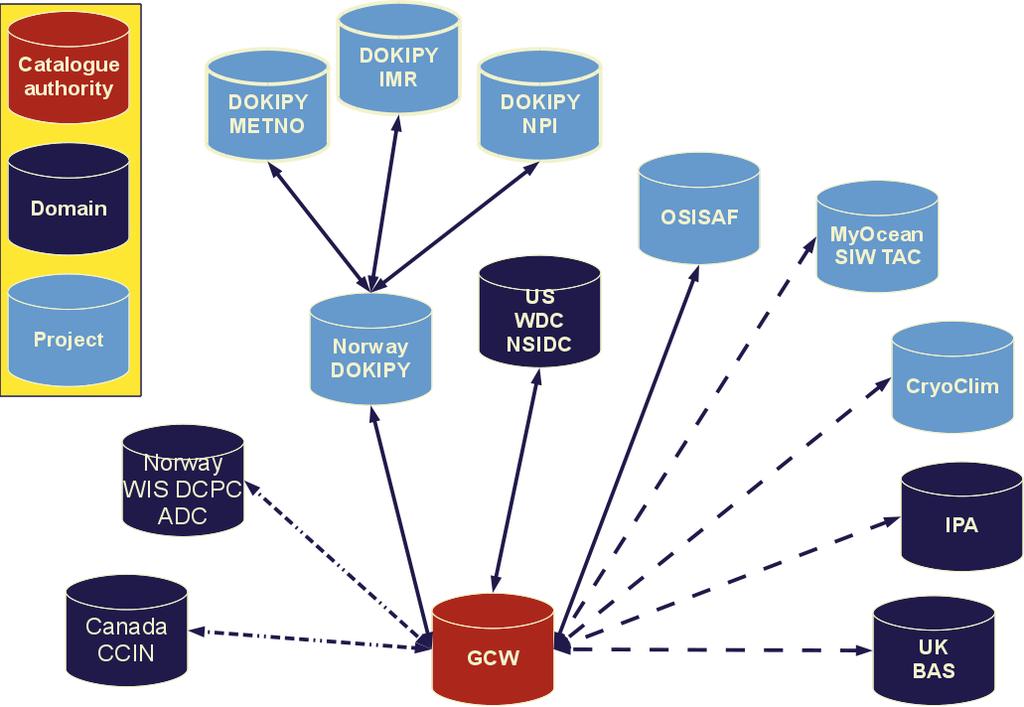
6 GCW will link infrastructure GCW aims to utilise relevant information no matter where it is located by linking and bridging existing infrastructure. GCW will not reinvent anything
7 Distributed data management in practise and why... Utilise existing infrastructure and efforts Avoid duplication of data Integrate existing infrastructure through Machine interfaces to metadata and data Exchange of metadata Sustainable solution Datasets are maintained by owners/creators Information on datasets are maintained by owners/creators Subsystems work...
8 Necessary steps for distributed data management Standardisation of documentation, file formats/access mechanisms etc supporting system interoperability Implementation of interfaces supporting the standards Willingness to utilise standards Willingness to properly document data Willingness to properly share data and information Translation between various interoperability standards/dialects Establish rules of operation

9 Distributed data management
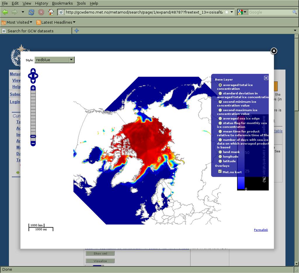
10 Preliminary functional requirements Users of cryospheric data, products and information should be able to easily find what they need. The portal should support both human and machine interfaces. While discovery and access to data is the primary functionality of any portal, experience shows that users soon request more advanced functionality, like visualisation, transformation, reformatting, and re-projection of datasets

11 GCW portal, catalogue component roles and preliminary priority It should support both Data producers Data consumers Data discovery has first priority Higher order functionality should be enabled wherever possible Visualisation Transformation
12 Technological considerations for catalogue interoperability Expose metadata using standard interoperability interfaces and documentation standards e.g. OAI-PMH, OGC CSW, ISO23950 e.g. ISO19115, GCMD DIF Preferably keep data online Implement machine interfaces in addition to human interfaces May enable integrated services across cryosphere datasets Self describing data formats/interfaces are highly preferred If authentication/authorisation is required, consider mechanisms like CAS, OpenSSO etc
13 Relevant frameworks for catalogue interoperability WMO Information System (WIS) ICSU World Data System (WDS) Group on Earth Observation (GEO) Regional frameworks E.g INSPIRE Domain specific frameworks Global Change Master Directory International Permafrost Association IPYDIS
14 Challenges developing the GCW portal Content management for editorial information How to handle the open data space Impacts on catalogue component What is a GCW dataset? How to address the diverse subsystems How many interfaces to support? Interoperability standards How to achieve a sustainable solution? For the editorial component For the catalogue Ensuring future relevance of GCW
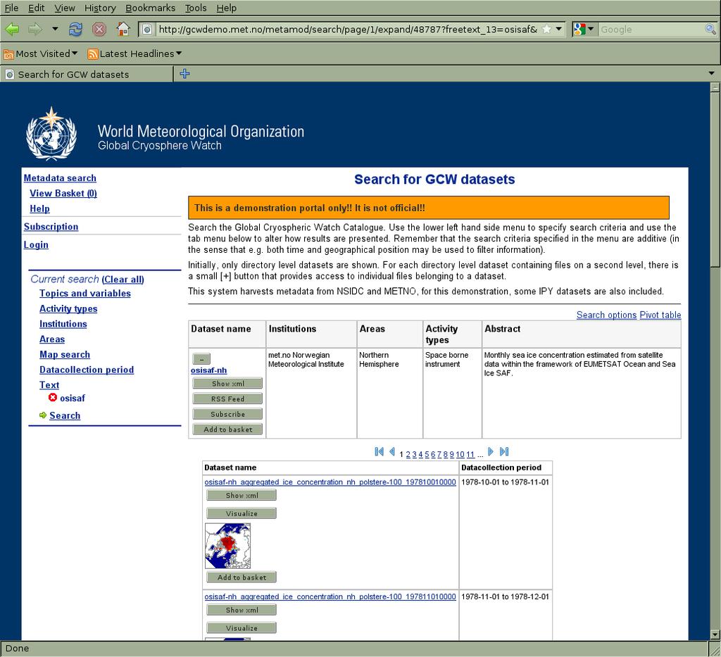
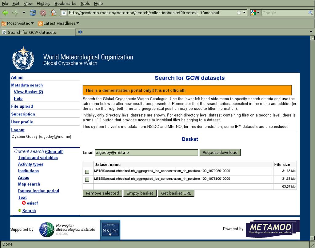
15 Demonstrator The demonstrator is available at Addresses only the catalogue component of the GCW portal Filtering of information is not implemented for all streams It contains currently information on IPY datasets documented in Norway Through metadata exchange between Norwegian Polar Institute, Institute of Marine Research and Norwegian Meteorological Institute EU FP7 DAMOCLES and EUMETSAT OSISAF datasets NSIDC data
16
17
18
19

20 Relation to WIS components
21
22 Preliminary plans for the demonstrator Update the software Improve filtering Move demonstrator to a new computer and database, linking with METNO WIS nodes Add regular harvest from CCIN Harvest has been tested, but ingestion into the database has yet not Examine interoperability towards e.g. BAS Examine interoperability towards IPA Examine sustainable visualisation and transformation of remote datasets
23 Questions for discussion Desired functionality of the portal Editorial component Catalogue component Organisational structure required To support the portal components Interaction with existing systems Which frameworks/systems to contact? Defining GCW datasets? Cost / benefit analysis Addressing requested functionality And resources available What is achievable with the resources available? How to consolidate a system description How to consolidate an implementation plan
Technical documentation. SIOS Data Management Plan
 Technical documentation SIOS Data Management Plan SIOS Data Management Plan Page: 2/10 SIOS Data Management Plan Page: 3/10 Versions Version Date Comment Responsible 0.3 2017 04 19 Minor modifications
Technical documentation. D2.4 KPI Specification
 Technical documentation D2.4 KPI Specification NorDataNet D2.4 KPI Specification Page: 2/6 Versions Version Date Comment Responsible 0.2 2016 11 25 Modified some statements to make them more precise, identified
The State of Arctic Data the IPY experience
 The State of Arctic Data the IPY experience Mark A. Parsons,Taco de Bruin, Scott Tomlinson, Øystein Godøy, Helen Campbell, Julie Leclert, Ellsworth LeDrew, David Carlson, and the IPY data community. 22
Metadata for Data Discovery: The NERC Data Catalogue Service. Steve Donegan
 Metadata for Data Discovery: The NERC Data Catalogue Service Steve Donegan Introduction NERC, Science and Data Centres NERC Discovery Metadata The Data Catalogue Service NERC Data Services Case study:
WP4: Data Forum. Øystein Godøy, Boris Radosavljević, Boris Biskaborn, Anna Irrgang
 WP4: Data Forum Øystein Godøy, Boris Radosavljević, Boris Biskaborn, Anna Irrgang Motivation INTERACT research stations generate data and metadata Long term monitoring Short term process studies External
Initial Operating Capability & The INSPIRE Community Geoportal
 INSPIRE Conference, Rotterdam, 15 19 June 2009 1 Infrastructure for Spatial Information in the European Community Initial Operating Capability & The INSPIRE Community Geoportal EC INSPIRE GEOPORTAL TEAM
Growing Variety and Volume of Remote Sensing and In Situ Data
 The Potential Role of the World Data Centers in the Global Earth Observing System of Systems and the International Polar Year: CIESIN Experience to Date Dr. Robert S. Chen Director and Senior Research
WMO WMO GLOBAL CRYOSPHERE WATCH
 WMO WMO GLOBAL CRYOSPHERE WATCH The Global Cryosphere Watch The GCW Steering Group Árni Snorrason (IMO), Chair, GCW Steering Group 2 Organization: GCW Conceptual Framework The WMO Executive Council expert
Developing the ICSU World Data System (WDS)
") Developing the ICSU World Data System (WDS) 2009-2010 Mustapha Mokrane ICSU Secretariat Science and Information Technology Officer ICSU s Vision (A world where) universal and equitable access to high quality
Developing the ICSU World Data System (WDS) 2009-2010 Mustapha Mokrane ICSU Secretariat Science and Information Technology Officer ICSU s Vision (A world where) universal and equitable access to high quality
The French Geoportal : linking discovery and view network services. INSPIRE Conference Krakow
 The French Geoportal : linking discovery and view network services ( BRGM ) D.Richard (IGN) F. Robida Context of the French Geoportal The governance mechanism Transversal organisation based on the Ministry
Data Product Catalogue. T. Loubrieu, M. Treguer, G. Maudire, IFREMER
 Data Product Catalogue T. Loubrieu, M. Treguer, G. Maudire, IFREMER High level Scope / Requirements Product definition : result of an action or process (aiming at fulfilling user's demand). For seadatanet
Long-term preservation for INSPIRE: a metadata framework and geo-portal implementation
 Long-term preservation for INSPIRE: a metadata framework and geo-portal implementation INSPIRE 2010, KRAKOW Dr. Arif Shaon, Dr. Andrew Woolf (e-science, Science and Technology Facilities Council, UK) 3
Next GEOSS der neue europäische GEOSS Hub
 DLR.de Folie 1 27.10.2016, Oberpfaffenhofen Next GEOSS der neue europäische GEOSS Hub J. Meyer-Arnek, A. Müller, G. Schreier DLR.de Folie 2 NextGEOSS-Konsortium Kick-Off: 16-18 JAN 2017 Project duration:
GeoDCAT-AP Representing geographic metadata by using the "DCAT application profile for data portals in Europe"
 GeoDCAT-AP Representing geographic metadata by using the "DCAT application profile for data portals in Europe" Andrea Perego, Vlado Cetl, Anders Friis-Christensen, Michael Lutz, Lorena Hernandez Joint
Developing data catalogue extensions for metadata harvesting in GIS
 University of Bergen Department of Informatics Developing data catalogue extensions for metadata harvesting in GIS Author: André Mossige Long master thesis June 2018 Acknowledgements I would like to thank
FP7-INFRASTRUCTURES Grant Agreement no Scoping Study for a pan-european Geological Data Infrastructure D 4.4
 FP7-INFRASTRUCTURES-2012-1 Grant Agreement no. 312845 Scoping Study for a pan-european Geological Data Infrastructure D 4.4 Report on recommendations for implementation of the EGDI Deliverable number D4.4
The European Commission s science and knowledge service. Joint Research Centre
 The European Commission s science and knowledge service Joint Research Centre GeoDCAT-AP The story so far Andrea Perego, Antonio Rotundo, Lieven Raes GeoDCAT-AP Webinar 6 June 2018 What is GeoDCAT-AP Geospatial
Data discovery and access via the SeaDataNet CDI system
 Data discovery and access via the SeaDataNet CDI system Central dataproducts and data services on distributed data. Peter Thijsse MARIS CLIPC IS-ENES workshop, KNMI, November 2014 Outline 1. Introduction
(Geo)DCAT-AP Status, Usage, Implementation Guidelines, Extensions
DCAT-AP Status, Usage, Implementation Guidelines, Extensions") (Geo)DCAT-AP Status, Usage, Implementation Guidelines, Extensions HMA-AWG Meeting ESRIN (Room D) 20. May 2016 Uwe Voges (con terra GmbH) GeoDCAT-AP European Data Portal European Data Portal (EDP): central
(Geo)DCAT-AP Status, Usage, Implementation Guidelines, Extensions HMA-AWG Meeting ESRIN (Room D) 20. May 2016 Uwe Voges (con terra GmbH) GeoDCAT-AP European Data Portal European Data Portal (EDP): central
The IODE Ocean Data Portal: Concept Paper (by Greg Reed, Nick Michailov, Peter Pissierssens)
") Limited distribution IOC/IODE-XIX/15 22 February 2007 Original: English INTERGOVERNMENTAL OCEANOGRAPHIC COMMISSION (of UNESCO) Nineteenth Session of the IOC Committee on International Oceanographic Data
Limited distribution IOC/IODE-XIX/15 22 February 2007 Original: English INTERGOVERNMENTAL OCEANOGRAPHIC COMMISSION (of UNESCO) Nineteenth Session of the IOC Committee on International Oceanographic Data
Esri Geoportal Server
 Esri Geoportal Server Implementing a Spatial Data Infrastructure @martenhogeweg Esri Geoportal Server Extending ArcGIS to enable discovery and use of geospatial resources in heterogeneous environments
European Marine Data Exchange
 European Marine Data Exchange By Dick M.A. Schaap MARIS (NL) EU SeaDataNet Technical Coordinator EU EMODnet Ingestion Coordinator Noordzeedagen 2018 - October 2018 Acquisition of ocean and marine data
/// INTEROPERABILITY BETWEEN METADATA STANDARDS: A REFERENCE IMPLEMENTATION FOR METADATA CATALOGUES
 /// Position Paper /// INTEROPERABILITY BETWEEN METADATA STANDARDS: A REFERENCE IMPLEMENTATION FOR METADATA CATALOGUES /// Keywords: Public administration, Metadata, Geographical Information, Geospatial
IMPLEMENTATION OF THE ELEMENTS INFRASTRUCTURE IN POLAND OF THE NATIONAL LEVEL METADATA
 IMPLEMENTATION OF THE ELEMENTS OF THE NATIONAL LEVEL METADATA INFRASTRUCTURE IN POLAND Bartosz Kopańczyk, kopanczyk@geoscope.pl Tomasz Kubik, tomasz.kubik@pwr.wroc.pl Paweł Netzel, netzel@meteo.uni.wroc.pl
Geo Seas A pan European infrastructure for the management of marine geological and geophysical data
 Geo Seas A pan European infrastructure for the management of marine geological and geophysical data Colin Graham (BGS), Dick Schaap (MARIS), Paolo Diviacco (OGS) & Helen Glaves (BGS) Integrated Infrastructure
INSPIRE & Environment Data in the EU
 INSPIRE & Environment Data in the EU Andrea Perego Research Data infrastructures for Environmental related Societal Challenges Workshop @ pre-rda P6 Workshops, Paris 22 September 2015 INSPIRE in a nutshell
Visual Core Description
 Visual Core Description and Information Structure Hans-Joachim Wallrabe-Adams, MARUM Ronald Conze, OSG/ICDP Colin Graham, ESO 8.5.2006 Expeditions - Information Structure Drilling Information System DIS/XDIS
- C3Grid Stephan Kindermann, DKRZ. Martina Stockhause, MPI-M C3-Team
 A Collaborative Environment for Climate Data Handling - Stephan Kindermann, DKRZ Martina Stockhause, MPI-M C3-Team 10.06. 2008 Motivation Model Output Data + Observation Data + TeraByte Analysis Data Expected
CGMS WMO Task Force on Metadata Implementation Progress. Presented to IPET-SUP agenda item 12.2
 CGMS WMO Task Force on Metadata Implementation Progress Presented to IPET-SUP 17-03-2015 agenda item 12.2 Overview CGMS-WMO-Task Force on Metadata Implementation Refresher Why such Task Force Task Force
Interoperability in Science Data: Stories from the Trenches
 Interoperability in Science Data: Stories from the Trenches Karen Stocks University of California San Diego Open Data for Open Science Data Interoperability Microsoft escience Workshop 2012 Interoperability
The Scottish Spatial Data Infrastructure (SSDI)
") The Scottish Spatial Data Infrastructure (SSDI) INSPIRE Conference Istanbul Monday 25 th June 2012 15:55 Geoportals and registries II Tim Duffy BGS Edinburgh (trd@bgs.ac.uk) Shona Nicol Alex Ramage NERC
The Scottish Spatial Data Infrastructure (SSDI) INSPIRE Conference Istanbul Monday 25 th June 2012 15:55 Geoportals and registries II Tim Duffy BGS Edinburgh (trd@bgs.ac.uk) Shona Nicol Alex Ramage NERC
EarthLookCZ as Czech way to GMES
 EarthLookCZ as Czech way to GMES Karel Charvat 1 and Petr Horak 1 1 WirelessInfo, Czech Republic, charvat@wirelessinfo.cz Abstract Global Monitoring for Environment and Security is one of 4 ranges of solutions
WHAT ISINTEROPERABILITY? (AND HOW DO WE MEASURE IT?) INSPIRE Conference 2011 Edinburgh, UK
 INSPIRE Conference 2011 Edinburgh, UK") WHAT ISINTEROPERABILITY? (AND HOW DO WE MEASURE IT?) INSPIRE Conference 2011 Edinburgh, UK Motivation Interoperability is a core objective of INSPIRE Interoperability a major element of GEOSS Strategic
WHAT ISINTEROPERABILITY? (AND HOW DO WE MEASURE IT?) INSPIRE Conference 2011 Edinburgh, UK Motivation Interoperability is a core objective of INSPIRE Interoperability a major element of GEOSS Strategic
EVOlution of EO Online Data Access Services (EVO-ODAS) ESA GSTP-6 Project by DLR, EOX and GeoSolutions (2015/ /04)
 ESA GSTP-6 Project by DLR, EOX and GeoSolutions (2015/ /04)") EVOlution of EO Online Data Access Services (EVO-ODAS) ESA GSTP-6 Project by DLR, EOX and GeoSolutions (2015/10 2017/04) 2016 Conference on Big Data from Space - BiDS 16, Tenerife, 15 th -17 th March Evolution
EVOlution of EO Online Data Access Services (EVO-ODAS) ESA GSTP-6 Project by DLR, EOX and GeoSolutions (2015/10 2017/04) 2016 Conference on Big Data from Space - BiDS 16, Tenerife, 15 th -17 th March Evolution
Leveraging metadata standards in ArcGIS to support Interoperability. Aleta Vienneau and Marten Hogeweg
 Leveraging metadata standards in ArcGIS to support Interoperability Aleta Vienneau and Marten Hogeweg Leveraging metadata standards in ArcGIS to support Interoperability Overview of metadata standards
Multi-disciplinary Interoperability: the EuroGEOSS Operating Capacities
 Multi-disciplinary Interoperability: the EuroGEOSS Operating Capacities Stefano Nativi (CNR) stefano.nativi@cnr.it Opening and context for Global Dimension Stream: EuroGEOSS contribution to the Global
Implementation and Use of OGC/HMA/WMO/ISO & Inspire Standards in EUMETSAT EO Portal
 Third Workshop on the use of GIS/OGC Standards in Meteorology 15-17 November 2010 at the Met Office, Exeter, UK Implementation and Use of OGC/HMA/WMO/ISO & Inspire Standards in EUMETSAT EO Portal Uwe Voges
SeaDataNet, Pan-European infrastructure for marine and ocean data management + EMODNET
 SeaDataNet, Pan-European infrastructure for marine and ocean data management + EMODNET By Dick M.A. Schaap Technical Coordinator SeaDataNet & Coordinator EMODNet Bathymetry San Francisco USA, 13 December
THE GEOSS PLATFORM TOWARDS A BIG EO DATA SYSTEM LINKING GLOBAL USERS AND DATA PROVIDERS
 THE PLATFORM TOWARDS A BIG EO DATA SYSTEM LINKING GLOBAL USERS AND DATA PROVIDERS J. Van Bemmelen (1), P. De Salvo (2), M. Santoro (3), P. Mazzetti (3), G. Colangeli (1), S. Nativi (4) (1) European Space
GENeric European Sustainable Information Space for Environment.
 GENeric European Sustainable Information Space for Environment http://www.genesis-fp7.eu/ Outline Introduction The GENESIS FP7 project The GENESIS solution s architecture GENESIS experience with INSPIRE
SAFER the GIGAS Effect
 SAFER the GIGAS Effect How INSPIRE, GMES and GEOSS are influencing EC projects Arnaud Cauchy 23/06/2010 Agenda GIGAS Project Summary SAFER Project Summary SAFER Original Approach GIGAS Influences SAFER
EUDAT-B2FIND A FAIR and Interdisciplinary Discovery Portal for Research Data
 EUDAT-B2FIND A FAIR and Interdisciplinary Discovery Portal for Research Data Heinrich Widmann, DKRZ Claudia Martens, DKRZ Open Science Days, Berlin, 17 October 2017 www.eudat.eu EUDAT receives funding
C3S Data Portal: Setting the scene
 C3S Data Portal: Setting the scene Baudouin Raoult Baudouin.raoult@ecmwf.int Funded by the European Union Implemented by Evaluation & QC function from European commission e.g.,fp7 Space call Selected set
Enabling Efficient Discovery of and Access to Spatial Data Services. CHARVAT, Karel, et al. Abstract
 Article Enabling Efficient Discovery of and Access to Spatial Data Services CHARVAT, Karel, et al. Abstract Spatial data represent valuable information and a basis for decision making processes in society.
Ambiguities in the Implementation of the INSPIRE directive for Metadata. J.Walther, F.Schenk
 Ambiguities in the Implementation of the INSPIRE directive for Metadata J.Walther, F.Schenk Errors and Ambiguities e.g. UseLimitation INSPIRE Metadata Implementing Rules: Technical Guidelines based on
Towards a pan-european infrastructure for marine and ocean data management + Importance of standards
 Towards a pan-european infrastructure for marine and ocean data management + Importance of standards By Dick M.A. Schaap MARIS Technical Coordinator SeaDataNet & ODIP Coordinator EMODnet Bathymetry Münster
Transboundary data interoperability for Maritime Spatial Planning. Yuji KATO
 Transboundary data interoperability for Maritime Spatial Planning Yuji KATO CONTEXT THE MARITIME SPATIAL PLANNING DIRECTIVE DIRECTIVE 2014/89/EU establishing a framework for Maritime Spatial Planning (MSP)
SeaDataNet, Pan-European infrastructure for marine ands ocean data management + EMODNET Preparatory Action Hydrographic and Seabed Mapping
 SeaDataNet, Pan-European infrastructure for marine ands ocean data management + EMODNET Preparatory Action Hydrographic and Seabed Mapping By Dick M.A. Schaap Technical Coordinator SeaDataNet & Coordinator
The GeoPortal Cookbook Tutorial
 The GeoPortal Cookbook Tutorial Wim Hugo SAEON/ SAEOS SCOPE OF DISCUSSION Background and Additional Resources Context and Concepts The Main Components of a GeoPortal Architecture Implementation Options
The GEO Discovery and Access Broker
 WGISS-43 The GEO Discovery and Access Broker S. Nativi (1), M. Santoro (1) (1) Institute of Atmospheric Pollution Research, National Research Council of Italy DOWNSTREAM MIDSTREAM end-users Applications
Oceanic Observatory for the Iberian Shelf
 Oceanic Observatory for the Iberian Shelf B.Vila Barcelona, 26th September 2016 Objectives: The Project Improve the oceanic observation at the North Western Iberian coast (meteorological, oceanographical
Bruce Wright, John Ward, Malcolm Field, Met Office, United Kingdom
 The Met Office s Logical Store Bruce Wright, John Ward, Malcolm Field, Met Office, United Kingdom Background are the lifeblood of the Met Office. However, over time, the organic, un-governed growth of
WMO Space Programme Update - Importance of RAII Satellite User Mechanism and Work Plan
 WMO Space Programme Update - Importance of RAII Satellite User Mechanism and Work Plan Stephan Bojinski World Meteorological Organization (WMO) sbojinski@wmo.int 3 rd Meeting of the Coordinating Group
Towards a pan-european infrastructure for marine and ocean data management + Importance of standards
 Towards a pan-european infrastructure for marine and ocean data management + Importance of standards By Dick M.A. Schaap Technical Coordinator SeaDataNet & Coordinator EMODnet Bathymetry Hydrography Day,
The Open Archives Initiative in Practice:
 The Open Archives Initiative in Practice: escholarship@uq Chris Taylor Manager, Information Access Service University of Queensland Library 8th October 2004 University of Queensland Library 1 Overview
Big Data Earth Observation Standardization elements Codrina Ilie TERRASIGNA TF7/SG5
 Big Data Earth Observation Standardization elements Codrina Ilie TERRASIGNA TF7/SG5 1 Earth Observation standardization intro 2 directions: 1. standardization of the Ground Segment Services: Heterogeneous
eresearch Collaboration across the Pacific:
 eresearch Collaboration across the Pacific: Marine Systems and Australian Marine Science Craig Johnson University of Tasmania Outline Introduce the Australian Ocean Network Possibilities for trans-pacific
Data Centre NetCDF Implementation Pilot
 Data Centre NetCDF Implementation Pilot Peter Miu EUMETSAT User Conference Oslo, Sep. 2011 Splinter Session, Facilitating Data Access and Utilisation Slide: 1 EUM/OPS/VWG/11/2600 V.1 What is this Pilot
How to get data into EFG and Metadata Quality
 How to get data into EFG and Metadata Quality EFG Information Meeting 3 July 2015 Cinema Ritrovato Festival, Bologna Co-funded by the Community Programme ICT- PSP EFG Information space Metadat a Metadat
Standards, standardisation & INSPIRE Status, issues, opportunities
 Standards, standardisation & INSPIRE Status, issues, opportunities INSPIRE Coordination Team 6 th MIG meeting, 13-14 June 2017 Joint Research Centre The European Commission's science and knowledge service
The NCAR Community Data Portal
 The NCAR Community Data Portal http://cdp.ucar.edu/ QuickTime and a TIFF (Uncompressed) decompressor are needed to see this picture. QuickTime and a TIFF (Uncompressed) decompressor are needed to see this
The UK Marine Environmental Data and Information Network MEDIN
 The UK Marine Environmental Data and Information Network MEDIN M. Charlesworth, R. Lowry, H. Freeman, J. Rapaport, B Seeley Content MEDIN - a brief overview for context Discovery Metadata Standard and
Using WIS to support WIGOS Steve Foreman WIS Branch
 Using WIS to support WIGOS Steve Foreman WIS Branch 1 Contents WIGOS, GDPFS and WIS Getting information out of WIS Putting information into WIS 2 WIGOS, GDPFS and WIS 3 GOS GTS GDPFS PWS Observations Calculations
Data and information sharing WMO global systems
 Data and information sharing WMO global systems Tommaso Abrate Scientific Officer World Meteorological Organization E-mail: tabrate@wmo.int 13 March, 2012 World Hydrological Cycle Observing System (WHYCOS)
B2SAFE metadata management
 B2SAFE metadata management version 1.2 by Claudio Cacciari, Robert Verkerk, Adil Hasan, Elena Erastova Introduction The B2SAFE service provides a set of functions for long term bit stream data preservation:
HMA Standardisation Status
 HMA Standardisation Status GSCB Meeting, 18-19 June 2009, Frascati P.G. Marchetti, ESA Y. Coene, SPACEBEL GSCB Meeting, 18 June 2009 Slide 1 Overview Context and Objectives Evolution of specifications
The NextGEOSS Project
 NextGEOSS GEOSS Interoperability workshop 28 August 2017 The NextGEOSS Project Marie-Francoise Voidrot, Bart De Lathouwer Open Geospatial Consortium Europe Nuno Catarino DEIMOS Head of Data Systems NextGEOSS
CLARIN for Linguists Portal & Searching for Resources. Jan Odijk LOT Summerschool Nijmegen,
 CLARIN for Linguists Portal & Searching for Resources Jan Odijk LOT Summerschool Nijmegen, 2014-06-23 1 Overview CLARIN Portal Find data and tools 2 Overview CLARIN Portal Find data and tools 3 CLARIN
The Common Framework for Earth Observation Data. US Group on Earth Observations Data Management Working Group
 The Common Framework for Earth Observation Data US Group on Earth Observations Data Management Working Group Agenda USGEO and BEDI background Concise summary of recommended CFEOD standards today Full document
Nunataryuk Data Management Plan
 EU grant agreement No. 773421 Deliverable No. 10.3 Nunataryuk Data Management Plan Project No. 773421 Version 1, April 2018 Start date of project: 2017/11/01 Due date of deliverable: 2018/04/30 Lead partner
The GIGAS Methodology
 The GIGAS Methodology Pier Giorgio Marchetti European Space Agency Earth Observation Programme Ground Segment Department pier.giorgio.marchetti@esa.int GIGAS Objectives GIGAS has the goal to promote the
Open Archives Initiatives Protocol for Metadata Harvesting Practices for the cultural heritage sector
 Open Archives Initiatives Protocol for Metadata Harvesting Practices for the cultural heritage sector Relais Culture Europe mfoulonneau@relais-culture-europe.org Community report A community report on
INTAROS Integrated Arctic Observation System
 INTAROS Integrated Arctic Observation System A project funded by EC - H2020-BG-09-2016 Coordinator: Stein Sandven Nansen Environmental and Remote Sensing Center, Norway Overall objective: to develop an
Copyright 2016 Datalynx Pty Ltd. All rights reserved. Datalynx Enterprise Data Management Solution Catalogue
 Datalynx Enterprise Data Management Solution Catalogue About Datalynx Vendor of the world s most versatile Enterprise Data Management software Licence our software to clients & partners Partner-based sales
The EOC Geoservice: Standardized Access to Earth Observation Data Sets and Value Added Products ABSTRACT
 The EOC Geoservice: Standardized Access to Earth Observation Data Sets and Value Added Products K. Dengler, T. Heinen, A. Huber, K. Molch, E. Mikusch German Aerospace Center (DLR) German Remote Sensing
Europeana, the prototype EDLfoundation Europeana Network Europeana, vs. 1.0 ThoughtLab Technical requirements
 Europeana European cultural heritage: united in its diversity Paul Doorenbosch KB - EDL Foundation 11th Special and University Libraries Conference, Opatija, 2 April 2009 Europeana, the prototype EDLfoundation
SmartHMA Introduction of SmartHMA project objectives
 SmartHMA Introduction of SmartHMA project objectives Daniel Zinkiewicz (daniel.zinkiewicz@wasat.pl) Wasat Sp. z o.o. Slide 1 SmartHMA SmartHMA SmartHMA mobile platform for deployment of HMA standardised
Preserva'on*Watch. What%to%monitor%and%how%Scout%can%help. KEEP%SOLUTIONS%www.keep7solu:ons.com
 Preserva'on*Watch What%to%monitor%and%how%Scout%can%help Luis%Faria%lfaria@keep.pt KEEP%SOLUTIONS%www.keep7solu:ons.com Digital%Preserva:on%Advanced%Prac::oner%Course Glasgow,%15th719th%July%2013 KEEP$SOLUTIONS
Chair, IASC-SAON Arctic Data Committee (ADC) Co-Lead, IARPC Arctic Data Sub-Team Co-Lead GEO Cold Regions Initiative
 Co-Lead, IARPC Arctic Data Sub-Team Co-Lead GEO Cold Regions Initiative") AOS Second Arctic Science Ministerial (ASM2) Theme 1: STRENGTHENING, INTEGRATING AND SUSTAINING ARCTIC OBSERVATIONS,FACILITATING ACCESS TO ARCTIC DATA, AND SHARING ARCTIC RESEARCH INFRASTRUCTURE Report
AOS Second Arctic Science Ministerial (ASM2) Theme 1: STRENGTHENING, INTEGRATING AND SUSTAINING ARCTIC OBSERVATIONS,FACILITATING ACCESS TO ARCTIC DATA, AND SHARING ARCTIC RESEARCH INFRASTRUCTURE Report
GSCB-Workshop on Ground Segment Evolution Strategy
 GSCB-Workshop on Ground Segment Evolution Strategy N. Hanowski, EOP-G, Ground Segment and Operations Department, nicolaus.hanowski@esa.int 24 September 2015 ESA UNCLASSIFIED For Official Use - Slide 1
Sensor Web Technology for Sharing Hydrological Measurement Data
 Sensor Web Technology for Sharing Hydrological Measurement Data IHW-netwerkdag 2017 Simon Jirka (jirka@52north.org) Sharing Hydrological Measurement Data Sensors capture a multitude of in-situ data relevant
Impacts of the new standard for metadata on geographic information (ISO :2014) on an INSPIRE discovery service
 on an INSPIRE discovery service") Impacts of the new standard for metadata on geographic information (ISO 19115-1:2014) on an INSPIRE discovery service Describing the process of migrating from an ISO19115 regional profile in Wallonia to
Impacts of the new standard for metadata on geographic information (ISO 19115-1:2014) on an INSPIRE discovery service Describing the process of migrating from an ISO19115 regional profile in Wallonia to
Data driven transformation of the public sector Tallinn, Estonia Head of unit 22 September 2016 European Commission
 Data driven transformation of the public sector Margarida Abecasis Head of unit European Commission E Leaders 2016 Tallinn, Estonia 22 September 2016 Interoperability Solutions and common Frameworks for
DATA SHARING AND DISCOVERY WITH ARCGIS SERVER GEOPORTAL EXTENSION. Clive Reece, Ph.D. ESRI Geoportal/SDI Solutions Team
 DATA SHARING AND DISCOVERY WITH ARCGIS SERVER GEOPORTAL EXTENSION Clive Reece, Ph.D. ESRI Geoportal/SDI Solutions Team Geoportal Extension for ArcGIS Server Context within an Enterprise Spatial Data Infrastructure
Introduction to INSPIRE. Network Services
 Introduction to INSPIRE. Network Services European Commission Joint Research Centre Institute for Environment and Sustainability Digital Earth and Reference Data Unit www.jrc.ec.europa.eu Serving society
Metadata of geographic information
 Metadata of geographic information Kai Koistinen Management of environmental data and information 4.10.2017 Topics Metadata of geographic information What is metadata? Metadata standards and recommendations
Publishing WWII aerial photographs in geographical and library information systems
 Elisabeth Verhelst *, Liesbeth Missel *, Bas Vanmeulebrouk **, Frans. I. Rip *** Publishing WWII aerial photographs in geographical and library information systems Keywords: WWII; aerial photography; geo
SeaDataNet, Pan-European infrastructure for marine and ocean data management + EMODNET Bathymetry
 SeaDataNet, Pan-European infrastructure for marine and ocean data management + EMODNET Bathymetry By Dick M.A. Schaap Technical Coordinator SeaDataNet & Coordinator EMODNet Bathymetry Limassol Cyprus,
EUDAT B2FIND A Cross-Discipline Metadata Service and Discovery Portal
 EUDAT B2FIND A Cross-Discipline Metadata Service and Discovery Portal Heinrich Widmann, DKRZ DI4R 2016, Krakow, 28 September 2016 www.eudat.eu EUDAT receives funding from the European Union's Horizon 2020
GEOSS Common Infrastructure and the Big Data challenges
 16th Workshop on meteorological operational systems 1-3 March, 2017 GEOSS Common Infrastructure and the Big Data challenges S. Nativi (1), J. Van Bemmelen (2), M. Santoro (1), G. Colangeli (2) O. Ochiai
The geospatial metadata catalogue. FOSS4G Barcelona. Jeroen Ticheler. Founder and chair. Director
 The geospatial metadata catalogue FOSS4G2010 - Barcelona Jeroen Ticheler Director Founder and chair GeoNetwork opensource Dutch National Geo Registry FAO GeoNetwork SwissTopo geocat.ch GeoNetwork history
Harvesting Open Government Data with DCAT-AP
 Fraunhofer FOKUS Institute for Open Communication Systems AlanDavidRobb / Pixabay (CC0) Harvesting Open Government Data with DCAT-AP Fabian Kirstein, 21. March 2018 The European Data Portal offers more
Increasing access to OA material through metadata aggregation
 Increasing access to OA material through metadata aggregation Mark Jordan Simon Fraser University SLAIS Issues in Scholarly Communications and Publishing 2008-04-02 1 We will discuss! Overview of metadata
DVB S OPERATOR STANDARDS FOR THE INTEGRATED GLOBAL DATA DISSEMINATION SERVICE (IGDDS)
") WMO CGMS DVB S OPERATOR STANDARDS FOR THE INTEGRATED GLOBAL DATA DISSEMINATION SERVICE (IGDDS) Version 1, April 2009 Table of Contents 1 INTRODUCTION... 3 1.1 Purpose and Scope... 3 1.2 Structure of the
WMO CGMS DVB S OPERATOR STANDARDS FOR THE INTEGRATED GLOBAL DATA DISSEMINATION SERVICE (IGDDS) Version 1, April 2009 Table of Contents 1 INTRODUCTION... 3 1.1 Purpose and Scope... 3 1.2 Structure of the
INSPIRE Download Service
 The OGC SOS as INSPIRE Download Service for (meteorological) l) Observation Data Simon Jirka (52 North) 29 th October 2014 5th Workshop on the use of GIS/OGC standards in meteorology Offenbach (Germany)
Call for Participation in AIP-6
 Call for Participation in AIP-6 GEOSS Architecture Implementation Pilot (AIP) Issue Date of CFP: 9 February 2013 Due Date for CFP Responses: 15 March 2013 Introduction GEOSS Architecture Implementation
Harmonisation of distributed geographic datasets - A model driven approach for geotechnical & footprint data.
 Harmonisation of distributed geographic datasets - A model driven approach for geotechnical & footprint data. Bart van den Berg (1,2), Bart Hulshof (1), Theo Tijssen (2) en Peter van Oosterom (2) (1) Shell/NAM,
How to Create a European INSPIRE Compliant Data Specification. Anja Hopfstock, BKG (Germany) Morten Borrebæk, SK (Norway)
 Morten Borrebæk, SK (Norway)") How to Create a European INSPIRE Compliant Data Specification Anja Hopfstock, BKG (Germany) Morten Borrebæk, SK (Norway) ESDIN Key Goals Further the ambition of the European Commission to create a European
How to Create a European INSPIRE Compliant Data Specification Anja Hopfstock, BKG (Germany) Morten Borrebæk, SK (Norway) ESDIN Key Goals Further the ambition of the European Commission to create a European
Data Management Glossary
 Data Management Glossary A Access path: The route through a system by which data is found, accessed and retrieved Agile methodology: An approach to software development which takes incremental, iterative
Harmonized operational observation data production at FMI
 Harmonized operational observation data production at FMI Minna Huuskonen and Lasse Latva Finnish Meteorological Institute (FMI) Erik Palmenin aukio 1, 00560 Helsinki, Finland Emails: minna.huuskonen@fmi.fi,