Transformative characteristics and research agenda for the SDI-SKI step change: A Cadastral Case Study
|
|
|
- Eustace Curtis
- 5 years ago
- Views:
Transcription


1 Transformative characteristics and research agenda for the SDI-SKI step change: A Cadastral Case Study Dr Lesley Arnold Research Fellow, Curtin University, CRCSI Director Geospatial Frameworks World Bank Consultant

2 Presentation Outline Limitations of SDIs Transformative Characteristics Explain methodologies case study SKI Architecture and Framework

3 The On-demand Generation Produced by La Reel House Media
4 SIRI has limitations Problem lies with how we organise our data

5 On-Demand Limitations The Query Questions are multifaceted Answers are context dependent Unable to be predicted
6 Limitations - Forecasting Demand Decoupling Point Push Model Pull Model Just in case Just enough Just in time Just in real-time Just for me Disaster Management Foundation Spatial Data Themes High Demand Data Themes and Areas Data as a Service Knowledge

7 On-Demand Limitations The SDI Data not machine-accessible Designed for Data-IN Data integration difficult


8 Limitations Web of Data Open Data Portal Spatial Data Infrastructure

9 On-Demand Limitations The Data Duplicate information Aggregated data = LCD Provenance unknown


10 On-Demand Revolution The Smart Phone Revolution in connectivity has created an On-demand Economy Access is now more important than ownership - Futurist Kevin Kelly


11 Transformative Characteristics SDI SKI When combined: Knowledge on Demand

12 Cadastre Vision A cadastral system that enables people to readily and confidently identify the location and extent of all rights, restrictions and responsibilities related to land and real property.


13 Cadastre Vision


14 Semantic Web Making Data Smart Third stage in the Evolution of the Web Web 1.0 Web 3.0 Web 2.0 One-way interaction Two-way participation Linked Data (Semantic Web)
15 Semantic Web (Web of Data) Data Provenance Domain Ontologies End-user Profiles Knowledge Core Data structure Data formats Data Core Sensor feeds Images and Videos Upper Ontologies Vocabularies Rule-bases Metadata URI/URL/URN Knowledge Inferencing WMS, WFS, WPS Process Ontologies Process Core Semantic Search Geoprocesses Natural Language Processing Semantic Queries Ranking and Rating Spatial analytics
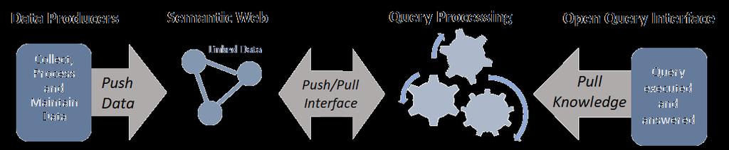
16 Query Processing


17 SDI Data Access Focussed SKI Knowledge Discovery Focussed

18 Research Agenda
19 Query Processing The Building blocks Knowledge Data Process
20 Data: Building Blocks Resource Description Framework Subject Predicate Object Property Land Parcel locatedwithin PartOfPremise locatedwithin Premise RDF is a standard model for data interchange on the Web.
21 Data: Building Blocks Resource Description Framework URI URI Land Parcel hasparceladdress LocatedWithinParcel LocatedWithinParcel Property hasparceladdress associatedwithpremise Premise URI URI Parcel Address URI Street Address URI Premise Address RDF Schema are used to build ontologies


22 Data: Building Blocks Unique Resource Identifier Shopping Centres URI unambiguously identifies a data resource so it can be found


 Utilities")
")
")
23 Data: Building Blocks Provenance Electronic Survey Plan Land Authority Cadastre (Data fudged) Utilities Cadastre (Inconsistent) Nationally Aggregated Cadastre (LCD) Generalised Cadastre (Land use map)

24 Knowledge: Building Blocks Vocabularies Controlled vocabularies agreed terms used to support data integration
25 Knowledge: Building Blocks Ontologies and Rules Rights, Restrictions and Responsibilities Person ownsland Land Parcel has has has Rights Restrictions Mining EPA Grants Building Water Chemical use Bores Days RULES: One bore per land parcel RULES: Street Address Ending in 1 = Sat, Wed has Parcel Address Responsibilities Heritage sites Drainage Electric Poles Ontologies set of concepts in a subject area
26 Process: Building Blocks Natural Language Processing What responsibilities are associated with this land? Refer to RRR Ontology Parcel, Property, Premise, Address Planar topology Within Current GPS location Polygon feature NLP Breaks down the query into manageable units
27 Knowledge: Building Blocks Semantic Search and Spatial Filtering Natural Language Processing Ontology Search Contextual Analysis Reasoning Engines Semantic Search understand searchers intent using contextual meanings Spatial Filtering narrowing the search by location


28 Process: Building Blocks Process Ontologies Identify data resources Shareable Heritage Sites Cadastre/Ownership Geo-reference Watering Days Land Use Identify Property Point in Polygon Spatial Intersect Process Ontology knowledge required to automatically compile, coordinate and run a series of geoprocess


29 Process: Building Blocks Geoprocesses CONFLATION FEDERATION Conflate single best dataset from multiple sources Federate joining adjacent datasets
30 What responsibilities are associated with this land Steps 1-6 Query Processing Step 1: Interpret Step 2: Retrieve Step 3: Process ONT PROV DATA START Input Query Executed Query Decomposed Semantic Search Spatial Filtering Process Ontology Process Orchestration
31 Steps 1-6 Query Processing Step 1: Interpret Step 2: Retrieve Step 3: Process ONT PROV DATA Provide More Context START Input Query Executed End-user Profile Query Decomposed Semantic Search PROV Spatial Filtering Process Ontology Process Orchestration Report, graph, map, image, video etc END Deliver Knowledge Rate Results Rank Results Portray Results Step 6: Deliver Step 5: Rank and Rate Step 4: Portray

32 Web of Data (Semantic Web) KNOWLEDGE DATA Query Processing and Spatial Analytics Open Data Portals Linked Open Data PROCESS TRUST (Ranking and Rating)
33 The SKI is not a centralised service or distinct entity. The SKI embodies the behaviour of resources available in the Web of Data.
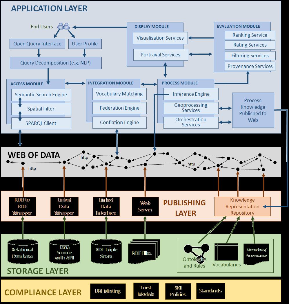
34 Architecture

35 SKI Framework


36 Spatial Knowledge Infrastructure For more information Download the White Paper at
37 Thank you
Transformative characteristics and research agenda for the SDI-SKI step change:
 Transformative characteristics and research agenda for the SDI-SKI step change: A Cadastral Case Study Dr Lesley Arnold Research Fellow, Curtin University, CRCSI Director Geospatial Frameworks World Bank
Reducing Consumer Uncertainty
 Spatial Analytics Reducing Consumer Uncertainty Towards an Ontology for Geospatial User-centric Metadata Introduction Cooperative Research Centre for Spatial Information (CRCSI) in Australia Communicate
Reducing Consumer Uncertainty Towards a Vocabulary for User-centric Geospatial Metadata
 Meeting Host Supporting Partner Meeting Sponsors Reducing Consumer Uncertainty Towards a Vocabulary for User-centric Geospatial Metadata 105th OGC Technical Committee Palmerston North, New Zealand Dr.
Serving Ireland s Geospatial as Linked Data on the Web
 Serving Ireland s Geospatial as Linked Data on the Web Dr. Atul Nautiyal ADAPT @ Trinity College Dublin The ADAPT Centre is funded under the SFI Research Centres Programme (Grant 13/RC/2106) and is co-funded
Canterbury SDI: lessons learned from post-earthquake recovery *
 UNITED NATIONS E/CONF.104/IP.16 ECONOMIC AND SOCIAL COUNCIL Twentieth United Nations Regional Cartographic Conference for Asia and the Pacific Jeju, 6-9 October 2015 Item 7(b) of the provisional agenda
Introduction to Geodatabase and Spatial Management in ArcGIS. Craig Gillgrass Esri
 Introduction to Geodatabase and Spatial Management in ArcGIS Craig Gillgrass Esri Session Path The Geodatabase - What is it? - Why use it? - What types are there? - What can I do with it? Query Layers
Using Linked Data Concepts to Blend and Analyze Geospatial and Statistical Data Creating a Semantic Data Platform
 Using Linked Data Concepts to Blend and Analyze Geospatial and Statistical Data Creating a Semantic Data Platform Hans Viehmann Product Manager EMEA ORACLE Corporation October 17, 2018 @SpatialHannes Safe
Publishing Statistical Data and Geospatial Data as Linked Data Creating a Semantic Data Platform
 Publishing Statistical Data and Geospatial Data as Linked Data Creating a Semantic Data Platform Hans Viehmann Product Manager EMEA ORACLE Corporation January 22, 2017 @SpatialHannes Safe Harbor Statement
Opus: University of Bath Online Publication Store
 Patel, M. (2004) Semantic Interoperability in Digital Library Systems. In: WP5 Forum Workshop: Semantic Interoperability in Digital Library Systems, DELOS Network of Excellence in Digital Libraries, 2004-09-16-2004-09-16,
LSGI 521: Principles of GIS. Lecture 5: Spatial Data Management in GIS. Dr. Bo Wu
 Lecture 5: Spatial Data Management in GIS Dr. Bo Wu lsbowu@polyu.edu.hk Department of Land Surveying & Geo-Informatics The Hong Kong Polytechnic University Contents 1. Learning outcomes 2. From files to
Land Administration and Management: Big Data, Fast Data, Semantics, Graph Databases, Security, Collaboration, Open Source, Shareable Information
 Land Administration and Management: Big Data, Fast Data, Semantics, Graph Databases, Security, Collaboration, Open Source, Shareable Information Platform Steven Hagan, Vice President, Engineering 1 Copyright
SEXTANT 1. Purpose of the Application
 SEXTANT 1. Purpose of the Application Sextant has been used in the domains of Earth Observation and Environment by presenting its browsing and visualization capabilities using a number of link geospatial
Semantics In Action For Proactive Policing
 Semantics In Action For Proactive Policing Jen Shorten Technical Delivery Architect, Consulting Services Jon Williams Senior Sales Engineer, UK Public Sector The Nature of Policing Is Changing The increasing
Compass INSPIRE Services. Compass INSPIRE Services. White Paper Compass Informatics Limited Block 8, Blackrock Business
 Compass INSPIRE Services White Paper 2010 Compass INSPIRE Services Compass Informatics Limited Block 8, Blackrock Business Park, Carysfort Avenue, Blackrock, County Dublin, Ireland Contact Us: +353 1 2104580
Introduction to INSPIRE. Network Services
 Introduction to INSPIRE. Network Services European Commission Joint Research Centre Institute for Environment and Sustainability Digital Earth and Reference Data Unit www.jrc.ec.europa.eu Serving society
Oracle Spatial and Graph: Benchmarking a Trillion Edges RDF Graph ORACLE WHITE PAPER NOVEMBER 2016
 Oracle Spatial and Graph: Benchmarking a Trillion Edges RDF Graph ORACLE WHITE PAPER NOVEMBER 2016 Introduction One trillion is a really big number. What could you store with one trillion facts?» 1000
COMPUTER AND INFORMATION SCIENCE JENA DB. Group Abhishek Kumar Harshvardhan Singh Abhisek Mohanty Suhas Tumkur Chandrashekhara
 JENA DB Group - 10 Abhishek Kumar Harshvardhan Singh Abhisek Mohanty Suhas Tumkur Chandrashekhara OUTLINE Introduction Data Model Query Language Implementation Features Applications Introduction Open Source
University of Bath. Publication date: Document Version Publisher's PDF, also known as Version of record. Link to publication
 Citation for published version: Patel, M & Duke, M 2004, 'Knowledge Discovery in an Agents Environment' Paper presented at European Semantic Web Symposium 2004, Heraklion, Crete, UK United Kingdom, 9/05/04-11/05/04,.
The Butterfly Effect. A proposal for distribution and management for butterfly data programs. Dave Waetjen SESYNC Butterfly Workshop May 10, 2012
 The Butterfly Effect A proposal for distribution and management for butterfly data programs Dave Waetjen SESYNC Butterfly Workshop May 10, 2012 http://butterfly.ucdavis.edu Citizen Science based Observation
INSPIRE: The ESRI Vision. Tina Hahn, GIS Consultant, ESRI(UK) Miguel Paredes, GIS Consultant, ESRI(UK)
 Miguel Paredes, GIS Consultant, ESRI(UK)") INSPIRE: The ESRI Vision Tina Hahn, GIS Consultant, ESRI(UK) Miguel Paredes, GIS Consultant, ESRI(UK) Overview Who are we? Introduction to ESRI Inc. and ESRI(UK) Presenters ArcGIS The ESRI Solution to
INSPIRE: The ESRI Vision Tina Hahn, GIS Consultant, ESRI(UK) Miguel Paredes, GIS Consultant, ESRI(UK) Overview Who are we? Introduction to ESRI Inc. and ESRI(UK) Presenters ArcGIS The ESRI Solution to
Evolution of INSPIRE interoperability solutions for e-government
 Evolution of INSPIRE interoperability solutions for e-government INSPIRE Implementation State-of-Play 26/05/2015 Robin S. Smith www.jrc.ec.europa.eu Serving society Stimulating innovation Supporting legislation
SII Law Organization Coordination activities Examples of good practices Education Technical matters Success stories Challenges
 SII Law Organization Coordination activities Examples of good practices Education Technical matters Success stories Challenges INSPIRE transposed by the legal act on Spatial Information Infrastructure
1 Copyright 2011, Oracle and/or its affiliates. All rights reserved.
 1 Copyright 2011, Oracle and/or its affiliates. All rights reserved. Integrating Complex Financial Workflows in Oracle Database Xavier Lopez Seamus Hayes Oracle PolarLake, LTD 2 Copyright 2011, Oracle
Publishing WWII aerial photographs in geographical and library information systems
 Elisabeth Verhelst *, Liesbeth Missel *, Bas Vanmeulebrouk **, Frans. I. Rip *** Publishing WWII aerial photographs in geographical and library information systems Keywords: WWII; aerial photography; geo
Consolidation Team INSPIRE Annex I data specifications testing Call for Participation
 INSPIRE Infrastructure for Spatial Information in Europe Technical documents Consolidation Team INSPIRE Annex I data specifications testing Call for Participation Title INSPIRE Annex I data specifications
Semantic Integration with Apache Jena and Apache Stanbol
 Semantic Integration with Apache Jena and Apache Stanbol All Things Open Raleigh, NC Oct. 22, 2014 Overview Theory (~10 mins) Application Examples (~10 mins) Technical Details (~25 mins) What do we mean
Polygon Analysis. Download and unzip the personal geodatabase polygon_analysis_lab.mdb from.
 NRM435 Spring 2019 Page 1 of 11 Polygon Analysis Download and unzip the personal geodatabase polygon_analysis_lab.mdb from /data/ The personal geodatabase contains five feature datasets.create an Arcmap
FIBO Metadata in Ontology Mapping
 FIBO Metadata in Ontology Mapping For Open Ontology Repository OOR Metadata Workshop VIII 02 July 2013 Copyright 2010 EDM Council Inc. 1 Overview The Financial Industry Business Ontology Introduction FIBO
Presented by Kit Na Goh
 Developing A Geo-Spatial Search Tool Using A Relational Database Implementation of the FGDC CSDGM Model Presented by Kit Na Goh Introduction Executive Order 12906 was issued on April 13, 1994 with the
IT Infrastructure for BIM and GIS 3D Data, Semantics, and Workflows
 IT Infrastructure for BIM and GIS 3D Data, Semantics, and Workflows Hans Viehmann Product Manager EMEA ORACLE Corporation November 23, 2017 @SpatialHannes Safe Harbor Statement The following is intended
[AVNICF-MCSASQL2012]: NICF - Microsoft Certified Solutions Associate (MCSA): SQL Server 2012
![[AVNICF-MCSASQL2012]: NICF - Microsoft Certified Solutions Associate (MCSA): SQL Server 2012](/thumbs/84/90579778.jpg "[AVNICF-MCSASQL2012]: NICF - Microsoft Certified Solutions Associate (MCSA): SQL Server 2012") [AVNICF-MCSASQL2012]: NICF - Microsoft Certified Solutions Associate (MCSA): SQL Server 2012 Length Delivery Method : 5 Days : Instructor-led (Classroom) Course Overview Participants will learn technical
[AVNICF-MCSASQL2012]: NICF - Microsoft Certified Solutions Associate (MCSA): SQL Server 2012 Length Delivery Method : 5 Days : Instructor-led (Classroom) Course Overview Participants will learn technical
2011 INTERNATIONAL COMPARISON PROGRAM
 2011 INTERNATIONAL COMPARISON PROGRAM 2011 ICP DATA ACCESS AND ARCHIVING POLICY GUIDING PRINCIPLES AND PROCEDURES FOR DATA ACCESS ICP Global Office June 2011 Contents I. PURPOSE... 3 II. CONTEXT... 3 III.
Business to Consumer Markets on the Semantic Web
 Workshop on Metadata for Security (W-MS) International Federated Conferences (OTM '03) Business to Consumer Markets on the Semantic Web Prof. Dr.-Ing. Robert Tolksdorf, Dipl.-Kfm. Christian Bizer Freie
Data Management Glossary
 Data Management Glossary A Access path: The route through a system by which data is found, accessed and retrieved Agile methodology: An approach to software development which takes incremental, iterative
Beyond spatial data infrastructure: knowledge and process extensions
 Beyond spatial data infrastructure: and process extensions by Wim Hugo, MBV Equsys Starting in 2005, the CSIR, SAEON, and a number of other stakeholders have collaborated [1] to conceptualise, define,
Enterprise Semantic Technology
 Enterprise Semantic Technology Industrializing Your Organization's Semantic Technology Platform SPEAKER: Thomas Kelly, Practice Director Semantic Technology Center of Excellence Enterprise Information
European Location Framework (ELF) acting as a facilitator implementing INSPIRE
 acting as a facilitator implementing INSPIRE") www.eurogeographics.org European Location Framework (ELF) acting as a facilitator implementing INSPIRE Saulius Urbanas, Mick Cory (EuroGeographics) 29 October 2016 Copyright 2013 EuroGeographics EuroGeographics
www.eurogeographics.org European Location Framework (ELF) acting as a facilitator implementing INSPIRE Saulius Urbanas, Mick Cory (EuroGeographics) 29 October 2016 Copyright 2013 EuroGeographics EuroGeographics
ISA Action 1.17: A Reusable INSPIRE Reference Platform (ARE3NA)
") ISA Action 1.17: A Reusable INSPIRE Reference Platform (ARE3NA) Expert contract supporting the Study on RDF and PIDs for INSPIRE Deliverable D.EC.3.2 RDF in INSPIRE Open issues, tools, and implications
ISA Action 1.17: A Reusable INSPIRE Reference Platform (ARE3NA) Expert contract supporting the Study on RDF and PIDs for INSPIRE Deliverable D.EC.3.2 RDF in INSPIRE Open issues, tools, and implications
GEOSPATIAL ENGINEERING COMPETENCIES. Geographic Information Science
 GEOSPATIAL ENGINEERING COMPETENCIES Geographic Information Science The character and structure of spatial information, its methods of capture, organisation, classification, qualification, analysis, management,
Basic Principles of MedWIS - WISE interoperability
 Co-ordination committee seminar of the national focal points Basic Principles of MedWIS - WISE interoperability Eduardo García ADASA Sistemas Nice - France Agenda WISE vs MedWIS WISE WISE DS WISE vs WISE
The cadastral data and standards based on XML in Poland
 The cadastral data and standards based on XML in Poland Jarosław Bydłosz, Piotr Parzych AGH University of Science and Technology Cracow, Poland 1 XML XML Extensible Markup Language Extensible Markup Language
GeoSPARQL Support and Other Cool Features in Oracle 12c Spatial and Graph Linked Data Seminar Culture, Base Registries & Visualisations
 GeoSPARQL Support and Other Cool Features in Oracle 12c Spatial and Graph Linked Data Seminar Culture, Base Registries & Visualisations Hans Viehmann Product Manager EMEA Oracle Corporation December 2,
Technology for Cadastral Applications. John R. Hacker, Jr. Marketing Manager Geospatial Applications
 Technology for Cadastral Applications John R. Hacker, Jr. Marketing Manager Geospatial Applications Agenda Cadastral Mapping Issues Precision and Accuracy Data Creation Data Management Data Publishing
DATA SHARING AND DISCOVERY WITH ARCGIS SERVER GEOPORTAL EXTENSION. Clive Reece, Ph.D. ESRI Geoportal/SDI Solutions Team
 DATA SHARING AND DISCOVERY WITH ARCGIS SERVER GEOPORTAL EXTENSION Clive Reece, Ph.D. ESRI Geoportal/SDI Solutions Team Geoportal Extension for ArcGIS Server Context within an Enterprise Spatial Data Infrastructure
GOVERNMENT GAZETTE REPUBLIC OF NAMIBIA
 GOVERNMENT GAZETTE OF THE REPUBLIC OF NAMIBIA N$7.20 WINDHOEK - 7 October 2016 No. 6145 CONTENTS Page GENERAL NOTICE No. 406 Namibia Statistics Agency: Data quality standard for the purchase, capture,
InfraGML. Linking pin between Geo and BIM. 4 november 2014
 InfraGML Linking pin between Geo and BIM Marcel Reuvers (Geonovum) 4 november 2014 GIS Roads DTM GIS scope: Scale 1:500 1:25:000 Coordinates system CRS Features Topology networks Themes Cables and pipes
How to Register where a Brownfield Land Register has been published.
 How to Register where a Brownfield Land Register has been published. Version 3 Date 21/12/2017 Contents About this guide 1 Why register the location of a published file? 2 The CSV file 2 Spatial files
Jeffery S. Horsburgh. Utah Water Research Laboratory Utah State University
 Advancing a Services Oriented Architecture for Sharing Hydrologic Data Jeffery S. Horsburgh Utah Water Research Laboratory Utah State University D.G. Tarboton, D.R. Maidment, I. Zaslavsky, D.P. Ames, J.L.
Challenges that can be overcome with the aid of ESA GIM Click to edit Master text styles
 Click to edit Agenda Master By: Egyptian Survey Authority Geographic Information Management System Kholoud Saad Salama Egypt (ESA GIM) 1 About Egyptian Survey Authority Third ESA GIM level Business Requirements
INSPIRE Spatial Data on the Web building a user-friendly webby SDI
 INSPIRE Spatial Data on the Web building a user-friendly webby SDI Linda van den Brink & Friso Penninga (presented by Rob van de Velde) Geonovum Agenda Objective of this presentation: Apply insights from
DIONYSUS: Towards Query-aware Distributed Processing of RDF Graph Streams
 DIONYSUS: Towards Query-aware Distributed Processing of RDF Graph Streams Syed Gillani, Gauthier Picard, Frederique Laforest Laboratoire Hubert Curien & Institute Mines St-Etienne, France GraphQ 2016 [Outline]
Geospatial Enterprise Search. June
 Geospatial Enterprise Search June 2013 www.voyagersearch.com www.voyagersearch.com/demo The Problem: Data Not Found The National Geospatial-Intelligence Agency is the primary source of geospatial intelligence
The What, Why, Who and How of Where: Building a Portal for Geospatial Data. Alan Darnell Director, Scholars Portal
 The What, Why, Who and How of Where: Building a Portal for Geospatial Data Alan Darnell Director, Scholars Portal What? Scholars GeoPortal Beta release Fall 2011 Production release March 2012 OLITA Award
EUDAT B2FIND A Cross-Discipline Metadata Service and Discovery Portal
 EUDAT B2FIND A Cross-Discipline Metadata Service and Discovery Portal Heinrich Widmann, DKRZ DI4R 2016, Krakow, 28 September 2016 www.eudat.eu EUDAT receives funding from the European Union's Horizon 2020
Table of Contents 1 Introduction A Declarative Approach to Entity Resolution... 17
 Table of Contents 1 Introduction...1 1.1 Common Problem...1 1.2 Data Integration and Data Management...3 1.2.1 Information Quality Overview...3 1.2.2 Customer Data Integration...4 1.2.3 Data Management...8
ICT-SHOK Project Proposal: PROFI
 ICT-SHOK Project Proposal: PROFI Full Title: Proactive Future Internet: Smart Semantic Middleware Overlay Architecture for Declarative Networking ICT-SHOK Programme: Future Internet Project duration: 2+2
Detailed analysis + Integration plan
 Outline Integration methodology Detailed analysis + Integration plan Conclusions 2 Outline Integration methodology Detailed analysis + Integration plan Conclusions 3 EULF-ISA Integration: methodology Phase
Open And Linked Data Oracle proposition Subtitle
 Presented with Open And Linked Data Oracle proposition Subtitle Pascal GUY Master Sales Consultant Cloud Infrastructure France May 30, 2017 Copyright 2014, Oracle and/or its affiliates. All rights reserved.
Visual Concept Detection and Linked Open Data at the TIB AV- Portal. Felix Saurbier, Matthias Springstein Hamburg, November 6 SWIB 2017
 Visual Concept Detection and Linked Open Data at the TIB AV- Portal Felix Saurbier, Matthias Springstein Hamburg, November 6 SWIB 2017 Agenda 1. TIB and TIB AV-Portal 2. Automated Video Analysis 3. Visual
Questionnaire 3D-Cadastres: status November 2010
 Questionnaire 3D-Cadastres: status vember This questionnaire is an activity of the FIG working group 3D-Cadastres -. The purpose of the survey is to make a world-wide inventory of the status of 3D-Cadastres
A5.2-D3 [3.5] Workflow Design and Construction Service Component Specification. Eva Klien (FHG), Christine Giger (ETHZ), Dániel Kristóf (FOMI)
![A5.2-D3 [3.5] Workflow Design and Construction Service Component Specification. Eva Klien (FHG), Christine Giger (ETHZ), Dániel Kristóf (FOMI)](/thumbs/90/102649368.jpg "A5.2-D3 [3.5] Workflow Design and Construction Service Component Specification. Eva Klien (FHG), Christine Giger (ETHZ), Dániel Kristóf (FOMI)") Title: A5.2-D3 [3.0] A Lightweight Introduction to the HUMBOLDT Framework V3.0 Author(s)/Organisation(s): Daniel Fitzner (FhG), Thorsten Reitz (FhG) Working Group: Architecture Team / WP5 References: A5.2-D3
Title: A5.2-D3 [3.0] A Lightweight Introduction to the HUMBOLDT Framework V3.0 Author(s)/Organisation(s): Daniel Fitzner (FhG), Thorsten Reitz (FhG) Working Group: Architecture Team / WP5 References: A5.2-D3
Enterprise Geographic Information Servers. Dr David Maguire Director of Products Kevin Daugherty ESRI
 Enterprise Geographic Information Servers Dr David Maguire Director of Products Kevin Daugherty ESRI Outline Introduction Enterprise GIS vs. Spatially-enabled IS Architectures for building Enterprise GIS
Semantics and Ontologies for Geospatial Information. Dr Kristin Stock
 Semantics and Ontologies for Geospatial Information Dr Kristin Stock Introduction The study of semantics addresses the issue of what data means, including: 1. The meaning and nature of basic geospatial
Overview of an address and purpose of the workshop
 ISO Workshop on address standards: Considering the issues related to an international address standard National Survey and Cadastre, Copenhagen, Denmark, 25 May 2008 Overview of an address and purpose
Study and guidelines on Geospatial Linked Data as part of ISA Action 1.17 Resource Description Framework
 DG Joint Research Center Study and guidelines on Geospatial Linked Data as part of ISA Action 1.17 Resource Description Framework 6 th of May 2014 Danny Vandenbroucke Diederik Tirry Agenda 1 Introduction
Towards the Semantic Desktop. Dr. Øyvind Hanssen University Library of Tromsø
 Towards the Semantic Desktop Dr. Øyvind Hanssen University Library of Tromsø Agenda Background Enabling trends and technologies Desktop computing and The Semantic Web Online Social Networking and P2P Computing
Chapter 6. Foundations of Business Intelligence: Databases and Information Management VIDEO CASES
 Chapter 6 Foundations of Business Intelligence: Databases and Information Management VIDEO CASES Case 1a: City of Dubuque Uses Cloud Computing and Sensors to Build a Smarter, Sustainable City Case 1b:
Selective 4D modelling framework for spatialtemporal Land Information Management System
 Selective 4D modelling framework for spatialtemporal Land Information Management System A. Doulamis, S. Soile, N. Doulamis, C. Chrisouli, N. Grammalidis, K. Dimitropoulos C. Manesis, C. Potsiou, C. Ioannidis
Lab 1: Exploring ArcMap and ArcCatalog In this lab, you will explore the ArcGIS applications ArcCatalog and ArcMap. You will learn how to use
 Lab 1: Exploring ArcMap and ArcCatalog In this lab, you will explore the ArcGIS applications ArcCatalog and ArcMap. You will learn how to use ArcCatalog to find maps and data and how to display maps in
Washington Statewide Trails Database Project
 Washington Statewide Trails Database Project Project Overview Washington still is missing a statewide trails database. To date, some of the state and federal hiking, biking, horse and rail trails data
CLICK HERE TO KNOW MORE
 CLICK HERE TO KNOW MORE GeoSmart Asia 2015 The importance of Geospatial Data Standardisation in GIS Corporate Database 30 September 2015 Khairul Faizi B Mohd Taib Technical Data, Technical Global PETRONAS
INSPIRE & Environment Data in the EU
 INSPIRE & Environment Data in the EU Andrea Perego Research Data infrastructures for Environmental related Societal Challenges Workshop @ pre-rda P6 Workshops, Paris 22 September 2015 INSPIRE in a nutshell
Integration of INSPIRE & SDMX data infrastructures for the 2021 population and housing census
 Integration of INSPIRE & SDMX data infrastructures for the 2021 population and housing census Nadezhda VLAHOVA, Fabian BACH, Ekkehard PETRI *, Vlado CETL, Hannes REUTER European Commission (*ekkehard.petri@ec.europa.eu
From Open Data to Data- Intensive Science through CERIF
 From Open Data to Data- Intensive Science through CERIF Keith G Jeffery a, Anne Asserson b, Nikos Houssos c, Valerie Brasse d, Brigitte Jörg e a Keith G Jeffery Consultants, Shrivenham, SN6 8AH, U, b University
Long-term preservation for INSPIRE: a metadata framework and geo-portal implementation
 Long-term preservation for INSPIRE: a metadata framework and geo-portal implementation INSPIRE 2010, KRAKOW Dr. Arif Shaon, Dr. Andrew Woolf (e-science, Science and Technology Facilities Council, UK) 3
INSPIRE & Linked Data: Bridging the Gap Part II: Tools for linked INSPIRE data
 Making the Web an Exploratory Place for Geospatial Knowledge INSPIRE & Linked Data: Bridging the Gap Part II: Tools for linked INSPIRE data Michalis Alexakis Spiros Athanasiou Nikos Georgomanolis Giorgos
Data is the new Oil (Ann Winblad)
") Data is the new Oil (Ann Winblad) Keith G Jeffery keith.jeffery@keithgjefferyconsultants.co.uk 20140415-16 JRC Workshop Big Open Data Keith G Jeffery 1 Data is the New Oil Like oil has been, data is Abundant
Data is the new Oil (Ann Winblad) Keith G Jeffery keith.jeffery@keithgjefferyconsultants.co.uk 20140415-16 JRC Workshop Big Open Data Keith G Jeffery 1 Data is the New Oil Like oil has been, data is Abundant
The European Commission s science and knowledge service. Joint Research Centre
 The European Commission s science and knowledge service Joint Research Centre GeoDCAT-AP The story so far Andrea Perego, Antonio Rotundo, Lieven Raes GeoDCAT-AP Webinar 6 June 2018 What is GeoDCAT-AP Geospatial
SDI Workshop ESDIN Best Practices INSPIRE conference, Edinburgh. Arnulf Christl, Metaspatial
 SDI Workshop ESDIN Best Practices 2011-06-28 INSPIRE conference, Edinburgh Arnulf Christl, Metaspatial Download this slide set as ODP or PDF at http://arnulf.us/publications Arnulf Christl Geospatially
Initial Operating Capability & The INSPIRE Community Geoportal
 INSPIRE Conference, Rotterdam, 15 19 June 2009 1 Infrastructure for Spatial Information in the European Community Initial Operating Capability & The INSPIRE Community Geoportal EC INSPIRE GEOPORTAL TEAM
SCRREEN & the RMIS 2.0
 & the RMIS 2.0 Raw Materials Week Annual Critical Raw Material Event Daniel Cassard - BRGM 07 November 2017, Brussels 730227 knowledge management manages both structured data (from database) and unstructured
Design & Manage Persistent URIs
 Training Module 2.3 OPEN DATA SUPPORT Design & Manage Persistent URIs PwC firms help organisations and individuals create the value they re looking for. We re a network of firms in 158 countries with close
A Conceptual Design Towards Semantic Geospatial Data Access
 A Conceptual Design Towards Semantic Geospatial Data Access Mingzhen Wei 1, Tian Zhao 2, Dalia Varanka 1, E. Lynn Usery 1 1 U.S. Geological Survey, Rolla, MO, 65401, USA, {mwei, dvaranka, usery}@usgs.gov
Annabel Lee Enriquez Project Manager Getty Conservation Institute
 Annabel Lee Enriquez Project Manager Getty Conservation Institute aenriquez@getty.edu Outline Project History Inventories Conservation Science: DISCO Arches Version 4 Demo Arches Designer Arches Reference
Towards Linked Data and ontology development for the semantic enrichment of volunteered geo-information
 AGILE Link-VGI workshop, Helsinki 14 June 2016 Towards Linked Data and ontology development for the semantic enrichment of volunteered geo-information Rob Lemmens University of Twente, Faculty of Geo-Information
2011 INTERNATIONAL COMPARISON PROGRAM
 2011 INTERNATIONAL COMPARISON PROGRAM 2011 ICP DATA ACCESS AND ARCHIVING POLICY GUIDING PRINCIPLES AND PROCEDURES FOR DATA ACCESS ICP Global Office November 2011 Contents I. PURPOSE... 3 II. CONTEXT...
Utility Network Management in ArcGIS: Migrating Your Data to the Utility Network. John Alsup & John Long
 Utility Network Management in ArcGIS: Migrating Your Data to the Utility Network John Alsup & John Long Presentation Outline Utility Network Preparation - Migration Patterns - Understanding the Asset Package
Course Modules for MCSA: SQL Server 2016 Database Development Training & Certification Course:
 Course Modules for MCSA: SQL Server 2016 Database Development Training & Certification Course: 20762C Developing SQL 2016 Databases Module 1: An Introduction to Database Development Introduction to the
MY DEWETRA IPAFLOODS REPORT
 Grant Contract N. ECHO/SUB/2014/692292 Programme for Prevention, Preparedness and Response to Floods in the Western Balkans and Turkey IPA FLOODS Capacity Building Activities 2016 MY DEWETRA IPAFLOODS
W3C WoT call CONTEXT INFORMATION MANAGEMENT - NGSI-LD API AS BRIDGE TO SEMANTIC WEB Contact: Lindsay Frost at
 W3C WoT call 29.08.2018 CONTEXT INFORMATION MANAGEMENT - NGSI-LD API AS BRIDGE TO SEMANTIC WEB Contact: Lindsay Frost at NGSI-LD@etsi.org HOW COULD WOT AND NGSI-LD FIT TOGETHER? ETSI ISG CIM has been working
LIDER Survey. Overview. Number of participants: 24. Participant profile (organisation type, industry sector) Relevant use-cases
 Relevant use-cases") LIDER Survey Overview Participant profile (organisation type, industry sector) Relevant use-cases Discovering and extracting information Understanding opinion Content and data (Data Management) Monitoring
LIDER Survey Overview Participant profile (organisation type, industry sector) Relevant use-cases Discovering and extracting information Understanding opinion Content and data (Data Management) Monitoring
(Geo)DCAT-AP Status, Usage, Implementation Guidelines, Extensions
DCAT-AP Status, Usage, Implementation Guidelines, Extensions") (Geo)DCAT-AP Status, Usage, Implementation Guidelines, Extensions HMA-AWG Meeting ESRIN (Room D) 20. May 2016 Uwe Voges (con terra GmbH) GeoDCAT-AP European Data Portal European Data Portal (EDP): central
(Geo)DCAT-AP Status, Usage, Implementation Guidelines, Extensions HMA-AWG Meeting ESRIN (Room D) 20. May 2016 Uwe Voges (con terra GmbH) GeoDCAT-AP European Data Portal European Data Portal (EDP): central
Contents. Part I Setting the Scene
 Contents Part I Setting the Scene 1 Introduction... 3 1.1 About Mobility Data... 3 1.1.1 Global Positioning System (GPS)... 5 1.1.2 Format of GPS Data... 6 1.1.3 Examples of Trajectory Datasets... 8 1.2
Geographic Information Fundamentals Overview
 CEN TC 287 Date: 1998-07 CR 287002:1998 CEN TC 287 Secretariat: AFNOR Geographic Information Fundamentals Overview Geoinformation Übersicht Information géographique Vue d'ensemble ICS: Descriptors: Document
Abu Dhabi Spatial Data Infrastructure (AD-SDI) From Data to Geo-Intelligence. Apr 2013
 From Data to Geo-Intelligence. Apr 2013") Abu Dhabi Spatial Data Infrastructure (AD-SDI) From Data to Geo-Intelligence Apr 2013 The focus of the Abu Dhabi e-government Vision and Strategy is to enable government entities to provide integrated
Abu Dhabi Spatial Data Infrastructure (AD-SDI) From Data to Geo-Intelligence Apr 2013 The focus of the Abu Dhabi e-government Vision and Strategy is to enable government entities to provide integrated
ISO CTS2 and Value Set Binding. Harold Solbrig Mayo Clinic
 ISO 79 CTS2 and Value Set Binding Harold Solbrig Mayo Clinic ISO 79 Information technology - Metadata registries (MDR) Owning group is ISO/IEC JTC /SC 32 Organization responsible for SQL standard Six part
Event Stores (I) [Source: DB-Engines.com, accessed on August 28, 2016]
![Event Stores (I) [Source: DB-Engines.com, accessed on August 28, 2016]](/thumbs/83/87881853.jpg "Event Stores (I) [Source: DB-Engines.com, accessed on August 28, 2016]") Event Stores (I) Event stores are database management systems implementing the concept of event sourcing. They keep all state changing events for an object together with a timestamp, thereby creating a
Event Stores (I) Event stores are database management systems implementing the concept of event sourcing. They keep all state changing events for an object together with a timestamp, thereby creating a
GeoDCAT-AP Representing geographic metadata by using the "DCAT application profile for data portals in Europe"
 GeoDCAT-AP Representing geographic metadata by using the "DCAT application profile for data portals in Europe" Andrea Perego, Vlado Cetl, Anders Friis-Christensen, Michael Lutz, Lorena Hernandez Joint
Workflow Management in Spatial Studies:
 Workflow Management in Spatial Studies: Just an extra document or something with intelligence? Auteur: John Stuiver, Wageningen University Centre for Geo-Information Spatial information Answers to questions
PRODUCT BROCHURE ERDAS APOLLO MANAGING AND SERVING GEOSPATIAL INFORMATION
 PRODUCT BROCHURE ERDAS APOLLO MANAGING AND SERVING GEOSPATIAL INFORMATION ERDAS APOLLO Do you have large volumes of geospatial information, regularly updated data stores, and a distributed user base? Do