Bring Location Intelligence To Big Data Applications on Hadoop, Spark, and NoSQL
|
|
|
- Whitney Walters
- 6 years ago
- Views:
Transcription
1 Bring Location Intelligence To Big Data Applications on Hadoop, Spark, and NoSQL Siva Ravada Senior Director of Development Copyright 2015, Oracle and/or its affiliates. All rights reserved.
2 Program Agenda Overview Vector Data Processing Raster Data Processing Discussion 2


.")


3 What problems can Big Data Spatial analysis address? Data Harmonization using any location attribute (address, postal code, lat/long, placename, etc). Categorization and filtering based on location and proximity Preparation, validation and cleansing of Spatial and Raster data Visualizing and displaying results on a map


4 Data Harmonization: Linking information by location Are these data points related? Tweet: sailing by #goldengate Instagram image subtitle: 골든게이트교 * Text message: Driving on 101 North, just reached border between Marin County and San Francisco County GPS Sensor: N W Now find all data points around Golden Gate Bridge... * Golden Gate Bridge (in Korean)
5 What features does Big Data Spatial have? Data enrichment service API using GeoNames and geometry hierarchy data Spatial processing of data stored in HDFS. Raster processing operations: Mosaic and sub-set operations. Geodetic and Cartesian data MapReduce routines and for distance calculations, PointInPolygon, buffer creation, Categorization, KMeansClustering, binning, etc.. Hive support (new) HTML5 Map Visualization API
6 Program Agenda Overview Vector Data Processing Raster Data Processing Disccussion 6
7 Vector Data Type support All of the data types we support with the SDO_GEOMETRY are supported on the Hadoop and Spark platform Points, Lines, Polygons, Collections Including Arcs, compound line strings, NURBs, compound polygons, etc. Supports both 2D and 3D data types Supports both Cartesian and Geodetic data models Topological and distance operations Anyinteract, inside, distance, length, simplify, buffer, PointInPolygon
8 Vector spatial data storage in HDFS Customers load their data into HDFS using a loader of their choice We do not require the data to be in a format that we specify This makes it easy for customers to use any data format their applications prefer And the data can have other business data and not just spatial data We require the customer to provide the InputFormat/RecordReader class The RecordReader implementation reads the customer data record and produces an instance of JGeometry With this model we can support any data format customers use for their data

9 Store any business data with spatial information in HDFS Oracle JGeometry USER- PROVIDED InputFormat/ RecordReader Class* LOAD ANY FORMAT ANY BUSINESS DATA * Classes for Shapefile and GeoJSON formats provided HDFS
10 Spatial Index for Spatial Queries Spatial Index stored as a MapFile MapReduce Job with Index Copy the index to distributed cache Mapper reads the index data for the corresponding HDFS block Data Blocks Data Blocks HDFS Data Blocks Data Blocks Process only those records that return hits from the index search 11
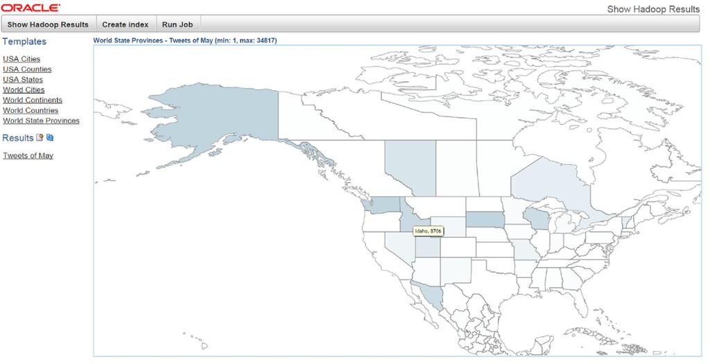
11 Vector Data Processing API Our API is broadly divided into three categories Functions that operate on a single geometry at a time Buffer, simplify, length, area, etc. Functions that operate on a pair of geometries at a time Range-Queries: these are the typical PointInPolygon, AnyInteract type of operations Analogous to our operators and relate functions in the DB Join-Queries: This is the typical Spatial-Join operation where two data sets are joined to find all the interacting pairs of geometries (next release) Functions that categorize and enrich data Associating a data set with a known geometry or named hierarchy For example, process all tweets for a time period and count how many tweets are associated with each city, county, state, etc.
12 Vector Data Processing API Functions Single Geometry Length Area Buffer Simplify Geometry Pairs Range Queries Point in Polygon Touch, Overlap, Intersect, Contains, Any Interaction Join Queries Interactions on sets of data E.g.: Find all the dropped cell calls in all coverage areas Categorization and Enrichment Associate a data set with a known geometry or named hierarchy Process all Tweets for a period of time and count how many are associated with each city, county, state, etc.
 or (countries, states, counties) as the hierarchy Big Data Spatial map-reduce job processes the customer data and produces a result")
13 Data Categorization Services Any hierarchical geometry data set for reference Customers choose a set of layers For example, they can select (continents, countries, cities) or (countries, states, counties) as the hierarchy Big Data Spatial map-reduce job processes the customer data and produces a result file
14 Vector Data Processing: PointInPolygon operation Consider a large customer data set that is loaded into HDFS We want to read each record, extract geometry information and check if the record is inside a given polygon geometry This can be run as a map-reduce job using our Java API from the Hadoop command line Customer creates a map-reduce job and specifies the JGeometry.Inside() method for record processing Customers write their own map-reduce jobs using our APIs

15 Spatial Binning 16

16 Spatial Join Process The spatial join process consists of the following phases: 1. Partitioning 2. Join 3. Duplicate removal p1 p2 join1 join1 join2 join2 DS1 DS1 DS2 join2 DS2 p3 p4 join3 join3 17
17 HIVE Support for Vector Data Provides support for standards based spatial data types ST_GEOMETRY type with constructors GeoJSON and WKT are natively supported Provides support for standard based spatial operators ST_RELATE, ST_CONTAINS, ST_DISTANCE, ST_BUFFER, etc. ST_GEOMETRY has member methods to output geometry as text AsJSON, AsWKT Provides spatial indexing capability Create a Spatial Index with the java API and use it in HIVE queries
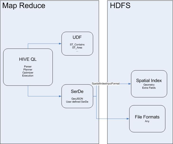
18 Analysis
 ROW FORMAT SERDE 'oracle.spatial.")

19 Spatial Hive integration Table creation CREATE EXTERNAL TABLE IF NOT EXISTS sample_tweets_index (id STRING, geometry STRING, followers_count STRING, friends_count STRING, location STRING) ROW FORMAT SERDE 'oracle.spatial.hadoop.vector.hive.json.geojsonserde' STORED AS INPUTFORMAT 'oracle.spatial.hadoop.vector.mapred.input.spatialindextextinputformat' OUTPUTFORMAT 'org.apache.hadoop.hive.ql.io.hiveignorekeytextoutputformat' LOCATION '/user/oracle/twitter/data'
, ST_Point(geometry, 8307), 0.")
20 Spatial Hive integration HiveQL Query SELECT id, followers_count, friends_count, location FROM sample_tweets WHERE ST_Contains( ST_Polygon('{"type": "Polygon","coordinates": [[[-106, 25], [-106, 30], [-104, 30], [-104, 25], [-106, 25]]]}', 8307), ST_Point(geometry, 8307), 0.5) and followers_count > 50;
21 Accessing BDSG data from the Database Oracle SQL Connectors for HDFS (OSCH) Files in HDFS are delimited text files (fields must be delimited using single-character markers, such as commas or tabs) Spatial data is stored as GeoJSON or WKT format An external table is defined to access the data from HDFS Spatial operations can be performed from the database using SQL JOIN between a DB table: CINEMA and HDFS table: TWEETS_EXT_TAB_FILE select sdo_geom.sdo_distance(ci.geometry, SDO_GEOMETRY(tw.geometry, 4326), 0.05, 'UNIT=MILE'), ci.name, tw.user_id from CINEMA ci, TWEETS_EXT_TAB_FILE tw where SDO_WITHIN_DISTANCE(ci.geometry, SDO_GEOMETRY(tw.geometry, 4326), 'DISTANCE=0.25 UNIT=MILE') = 'TRUE'
22 Accessing BDSG data from the Database Big Data SQL to access Spatial data in HDFS Files in HDFS are delimited text files (fields must be delimited using single-character markers, such as commas or tabs) or custom formatted files If Spatial data is stored as GeoJSON or WKT format, we provide the SerDe Spatial data stored in custom format, customers provide the SerDe An external table is defined to access the data from HDFS Spatial operations can be performed from the database using SQL JOIN between a DB table: CINEMA and HDFS table: TWEETS_EXT_TAB_FILE select sdo_geom.sdo_distance(ci.geometry, SDO_GEOMETRY(tw.geometry, 4326), 0.05, 'UNIT=MILE'), ci.name, tw.user_id from CINEMA ci, TWEETS_EXT_TAB_FILE tw where SDO_WITHIN_DISTANCE(ci.geometry, SDO_GEOMETRY(tw.geometry, 4326), 'DISTANCE=0.25 UNIT=MILE') = 'TRUE'
23 NoSQL Support In Vector API A NoSQL data source can be used as the input data for a Vector API Job A NoSQL input can be specified to a Vector Job in one the following ways Using the Oracle NoSQL Key-Value API Hadoop classes Using the Oracle NoSQL Table API Hadoop classes Using the special NoSQL classes provided by the Vector API
24 Spatial in Spark
25 Spatial Resilient Distributed Datasets (RDD) A Spatial RDD provides the regular RDD functionality plus spatial transformations and actions Current Spatial RDD implementations are SpatialJavaRDD and SpatialJavaPairRDD which are subclasses of JavaRDD and JavaPairRDD respectively Spatial transformations take a spatial predicate which can be used to spatially filter the RDD s data The following spatial operations can be used to perform a spatial transformations and actions IsInside Contains AnyInteract WithinDistance MBR Nearest Neighbors 26
26 SpatialJavaRDD Transformation Example 27
27 Distributed Spatial Index A Distributed Spatial Index is used to perfom faster spatial searches over a Spatial A spatial index may redistribute and repartition an existing spatial RDD in order to speed up queries A local index can be build for each RDD s partition in order to further accelerate spatial searches This feature is optional when creating a distributed spatial index. An existing Distributed Spatial RDD can be saved and loaded from a local or distributed file system using the save and load DistributedSpatialRDD s method The current Distributed Spatial Index implementation is based on QuadTree 28
28 HTML 5 API for MapVisualization
29 Big Data Spatial and Graph Spatial Vector Processing Framework Customer Application Sample Application MapReduce job MapReduce Framework, templates Spatial Operators, Functions S&G Java and HIVE API Spatial Enrichment, Categorization API Customer data Generated data JGeometry format RecordInfoProvider class GeoNames and Hierarchy data Oracle Provided Customer code Geospatial Vector data (any format) HDFS Enrichments, Categorizations results
30 Program Agenda Overview Vector Data Processing Raster Data Processing Discussion 31
31 Image Server HDFS storage for the image or raster files We can support dozens of file formats (GDAL supported formats) Images are geo-referenced Images can be in different coordinate systems and resolutions Three main capabilities Loader to load raster data from NFS to HDFS Mosaic and subset operations based on a virtual mosaic Image processing framework for raster analysis
32 Image Server Loader Customers usually have large volumes of raster data in traditional file systems We provide a GDAL based loader to load the data into HDFS such that the resulting HDFS blocks are organized for map-reduce jobs Many formats supported by GDAL are supported In V1, only support 3 band and single band images with float and byte data types In V2 added support for multi-band images
33 Raster Data Stored on HDFS When data is moved from traditional file system to HDFS, data should be organized such that a map-reduce job can process it with minimum amount of data transfer between data nodes We explain this concept with a raster data analysis example Raster Analysis with Hadoop Given a DEM, find the shaded relief model from it Storage Models considered Pixel data is partitioned over different HDFS blocks What are the best options for storing the DEM data on HDFS to enable this type of raster processing?
34 Shaded Relief calculation Input: NXM pixels where each pixel is a floating point number denoting elevation Find the shaded relief from the DEM Algorithm Look at the values of 8 neighbors and the current pixel value and generate a new pixel Needs the neighboring pixel values to calculate the new pixel value corresponding to the current pixel
35 Raster Data Analysis Framework Traditional algorithm will work very well in Map-Reduce framework Customers specify the pixel overlap required while loading the data into HDFS Once the data is loaded according to this overlap, rest of the processing can be done using standard algorithms Very effective for raster data processing as many map-reduce nodes can work together to produce the result in a short amount of time All the operations are performed on a catalogue of images Customers can logically combine certain number of images into a catalogue or into a virtual mosaic
36 Image Server Features Subset operation Find the set of images from a given catalogue covering a user specified region and generate a new image from the source files The new images will have user specified resolution and coordinate system These can be different for different images in the source catalogue and the resulting image can have a different value Mosaic the input images to deal with gaps and overlaps Create a new file with the specified file format Image Processing Functions
37 Raster Processing Local Map algebra operations localnot localif localadd localsubstract localmultiply localdivide localpow localsqrt localround locallog locallog10 localfloor localceil localnegate localabs localsin localcos localtan localsinh localcosh localtanh localasin localacos localatan localdefined localundefined
38 Shaded Relief Generation from DEM Hypothetical illumination of a surface by determining illumination values for each pixel Custom shaded reliefe algorithm can be plugged into our framework Users need to implement a few classes ImageProcessorInterface write results back in the ImageBandWritable data type 39

39 Image Processing on Hadoop This framework allows for complex image processing on raster data In this example we describe how a DEM can be processed to generate a shaded relief in addition to doing some raster algebra operations In this demo, we start with a DEM for the NAPA valley area 40
40 Image Processing on Hadoop The DEM can be processed using custom algorithms to generate a hillshade The whole process will execute as a map reduce program Users can take a non map-reduce custom algorithm and plug it into the framework 41


41 Raster Algebra on Hadoop We also support pixel level raster algebra operations on this raster data We can take the DEM and generate different versions of hillshaded rasters by selectively removing pixels with certain value Elevation>1000m Elevation>1800m Elevation>2800m 42
42 Big Data Spatial and Graph Spatial Raster Processing Framework Raster Analysis Application Sample Application Raster MapReduce framework S&G Java API Analysis Algorithms Customer data Subset Mosaic Raster Analysis API Generated data Oracle Provided Customer code Raster Data Files on NFS HDFS Raster catalog Derived Rasters GDAL Loader (GDAL formats) Rasters
43 Program Agenda Overview Vector Data Processing Raster Data Processing Discussion 44

44 Resources Oracle Big Data Spatial and Graph OTN product page: White papers, software downloads, documentation and videos Oracle Big Data Lite Virtual Machine - a free sandbox to get started: Hands On Lab for Big Data Spatial: tinyurl.com/bdsg-hol Blog examples, articles & tips: blogs.oracle.com/bigdataspatialgraph Oracle By Example tutorials: (search Big Data Spatial and @JeanIhm Oracle Spatial and Graph Group 45
Oracle Big Data Spatial and Graph: Spatial Features
 Oracle Big Data Spatial and Graph: Spatial Features January 28 th, 2016 Siva Ravada Senior Director of Development Copyright 2015, Oracle and/or its affiliates. All rights reserved. Program Agenda 1 2
Big Data Technologies and Geospatial Data Processing:
 Big Data Technologies and Geospatial Data Processing: A perfect fit Albert Godfrind Spatial and Graph Solutions Architect Oracle Corporation Agenda 1 2 3 4 The Data Explosion Big Data? Big Data and Geo
Oracle Big Data Spatial and Graph: Spatial Features Roberto Infante 11/11/2015 Latin America Geospatial Forum
 Oracle Big Data Spatial and Graph: Spatial Features Roberto Infante 11/11/2015 Latin America Geospatial Forum Overview of Spatial features Vector Data Processing Support spatial processing of data stored
Verarbeitung von Vektor- und Rasterdaten auf der Hadoop Plattform DOAG Spatial and Geodata Day 2016
 Verarbeitung von Vektor- und Rasterdaten auf der Hadoop Plattform DOAG Spatial and Geodata Day 2016 Hans Viehmann Product Manager EMEA ORACLE Corporation 12. Mai 2016 Safe Harbor Statement The following
Spatial Analytics Built for Big Data Platforms
 Spatial Analytics Built for Big Platforms Roberto Infante Software Development Manager, Spatial and Graph 1 Copyright 2011, Oracle and/or its affiliates. All rights Global Digital Growth The Internet of
What s New with SpaDal and Graph?
 What s New with SpaDal and Graph? Technologies to Be.er Understand Complex Rela8onships Jim Steiner Vice President, Product Management Server Technologies January, 2016 Copyright 2014, Oracle and/or its
Open And Linked Data Oracle proposition Subtitle
 Presented with Open And Linked Data Oracle proposition Subtitle Pascal GUY Master Sales Consultant Cloud Infrastructure France May 30, 2017 Copyright 2014, Oracle and/or its affiliates. All rights reserved.
BigData And the Zoo. Mansour Raad Federal GIS Conference 2014
 Federal GIS Conference 2014 February 10 11, 2014 Washington DC BigData And the Zoo Mansour Raad http://thunderheadxpler.blogspot.com/ mraad@esri.com @mraad What is BigData? Big data is like teenage sex:
Using Linked Data Concepts to Blend and Analyze Geospatial and Statistical Data Creating a Semantic Data Platform
 Using Linked Data Concepts to Blend and Analyze Geospatial and Statistical Data Creating a Semantic Data Platform Hans Viehmann Product Manager EMEA ORACLE Corporation October 17, 2018 @SpatialHannes Safe
Oracle Big Data Spatial and Graph User s Guide and Reference. Release 2.3
 Oracle Big Data Spatial and Graph User s Guide and Reference Release 2.3 E67958-12 August 2017 Oracle Big Data Spatial and Graph User s Guide and Reference, Release 2.3 E67958-12 Copyright 2015, 2017,
Publishing Statistical Data and Geospatial Data as Linked Data Creating a Semantic Data Platform
 Publishing Statistical Data and Geospatial Data as Linked Data Creating a Semantic Data Platform Hans Viehmann Product Manager EMEA ORACLE Corporation January 22, 2017 @SpatialHannes Safe Harbor Statement
Oracle Big Data Fundamentals Ed 2
 Oracle University Contact Us: 1.800.529.0165 Oracle Big Data Fundamentals Ed 2 Duration: 5 Days What you will learn In the Oracle Big Data Fundamentals course, you learn about big data, the technologies
Deploying Spatial Applications in Oracle Public Cloud
 Deploying Spatial Applications in Oracle Public Cloud David Lapp, Product Manager Oracle Spatial and Graph Oracle Spatial Summit at BIWA 2017 Safe Harbor Statement The following is intended to outline
Oracle Big Data SQL. Release 3.2. Rich SQL Processing on All Data
 Oracle Big Data SQL Release 3.2 The unprecedented explosion in data that can be made useful to enterprises from the Internet of Things, to the social streams of global customer bases has created a tremendous
Oracle Big Data. A NA LYT ICS A ND MA NAG E MENT.
 Oracle Big Data. A NALYTICS A ND MANAG E MENT. Oracle Big Data: Redundância. Compatível com ecossistema Hadoop, HIVE, HBASE, SPARK. Integração com Cloudera Manager. Possibilidade de Utilização da Linguagem
Oracle Big Data Fundamentals Ed 1
 Oracle University Contact Us: +0097143909050 Oracle Big Data Fundamentals Ed 1 Duration: 5 Days What you will learn In the Oracle Big Data Fundamentals course, learn to use Oracle's Integrated Big Data
Deep Learning und Graphenanalyse im Einsatz gegen Hacker
 Deep Learning und Graphenanalyse im Einsatz gegen Hacker Hans Viehmann Product Manager EMEA ORACLE Corporation DOAG Konferenz 2017 @SpatialHannes Safe Harbor Statement The following is intended to outline
Quick Deployment Step-by-step instructions to deploy Oracle Big Data Lite Virtual Machine
 Quick Deployment Step-by-step instructions to deploy Oracle Big Data Lite Virtual Machine Version 4.11 Last Updated: 1/10/2018 Please note: This appliance is for testing and educational purposes only;
Quick Deployment Step- by- step instructions to deploy Oracle Big Data Lite Virtual Machine
 Quick Deployment Step- by- step instructions to deploy Oracle Big Data Lite Virtual Machine Version 4.1.0 Please note: This appliance is for testing and educational purposes only; it is unsupported and
Oracle Big Data Spatial and Graph
 Oracle Big Data Spatial and Graph User's Guide and Reference Release 2.0 E67958-04 August 2016 Oracle Big Data Spatial and Graph User's Guide and Reference, Release 2.0 E67958-04 Copyright 2016, Oracle
Serving Imagery with ArcGIS Server 10.1
 Serving Imagery with ArcGIS Server 10.1 Presented by: André Piasta apiasta@esri.ca Esri Canada Users Conference Calgary, AB 28 May 2013 Today s Agenda ArcGIS server and image services Publishing of imagery
Oracle Big Data SQL High Performance Data Virtualization Explained
 Keywords: Oracle Big Data SQL High Performance Data Virtualization Explained Jean-Pierre Dijcks Oracle Redwood City, CA, USA Big Data SQL, SQL, Big Data, Hadoop, NoSQL Databases, Relational Databases,
Geospatial Analytics at Scale
 Geospatial Analytics at Scale Milos Milovanovic CoFounder & Data Engineer milos@thingsolver.com Things Solver ENLIGHTEN YOUR DATA What we do? Advanced Analytics company based in Belgrade, Serbia. We are
May 22, 2013 Ronald Reagan Building and International Trade Center Washington, DC USA
 May 22, 2013 Ronald Reagan Building and International Trade Center Washington, DC USA 1 To 9. D 1. 2. 3. Leveraging Advanced Oracle Spatial and Graph Features Daniel Geringer Senior Software Development
Introduction to BigData, Hadoop:-
 Introduction to BigData, Hadoop:- Big Data Introduction: Hadoop Introduction What is Hadoop? Why Hadoop? Hadoop History. Different types of Components in Hadoop? HDFS, MapReduce, PIG, Hive, SQOOP, HBASE,
May 2012 Oracle Spatial User Conference
 1 May 2012 Oracle Spatial User Conference May 23, 2012 Ronald Reagan Building and International Trade Center Washington, DC USA Siva Ravada Director of Development Oracle Spatial Steve MacCabe Product
Managing Imagery and Raster Data Using Mosaic Datasets
 2013 Esri International User Conference July 8 12, 2013 San Diego, California Technical Workshop Managing Imagery and Raster Data Using Mosaic Datasets Hong Xu, Prashant Mangtani Esri UC2013. Technical
Hive and Shark. Amir H. Payberah. Amirkabir University of Technology (Tehran Polytechnic)
") Hive and Shark Amir H. Payberah amir@sics.se Amirkabir University of Technology (Tehran Polytechnic) Amir H. Payberah (Tehran Polytechnic) Hive and Shark 1393/8/19 1 / 45 Motivation MapReduce is hard to
Hive and Shark Amir H. Payberah amir@sics.se Amirkabir University of Technology (Tehran Polytechnic) Amir H. Payberah (Tehran Polytechnic) Hive and Shark 1393/8/19 1 / 45 Motivation MapReduce is hard to
Big Data Analytics using Apache Hadoop and Spark with Scala
 Big Data Analytics using Apache Hadoop and Spark with Scala Training Highlights : 80% of the training is with Practical Demo (On Custom Cloudera and Ubuntu Machines) 20% Theory Portion will be important
May 21, 2014 Walter E. Washington Convention Center Washington, DC USA. Copyright 2014, Oracle and/or its affiliates. All rights reserved.
 May 21, 2014 Walter E. Washington Convention Center Washington, DC USA 1 How to Build a Better GIS Application Siva Ravada Senior Director of Development Spatial and Graph & MapViewer Oracle Program Agenda
Oracle Big Data Spatial and Graph
 Oracle Big Data Spatial and Graph User's Guide and Reference Release 1.2 E67958-03 May 2016 Oracle Big Data Spatial and Graph User's Guide and Reference, Release 1.2 E67958-03 Copyright 2015, 2016, Oracle
Copyright 2012, Oracle and/or its affiliates. All rights reserved.
 1 Big Data Connectors: High Performance Integration for Hadoop and Oracle Database Melli Annamalai Sue Mavris Rob Abbott 2 Program Agenda Big Data Connectors: Brief Overview Connecting Hadoop with Oracle
May 22, 2013 Ronald Reagan Building and International Trade Center Washington, DC USA
 May 22, 2013 Ronald Reagan Building and International Trade Center Washington, DC USA 1 To 9. D 1. 2. 3. Performance, Performance, Performance What You Need To Know About Exadata Daniel Geringer Senior
Blended Learning Outline: Developer Training for Apache Spark and Hadoop (180404a)
") Blended Learning Outline: Developer Training for Apache Spark and Hadoop (180404a) Cloudera s Developer Training for Apache Spark and Hadoop delivers the key concepts and expertise need to develop high-performance
Blended Learning Outline: Developer Training for Apache Spark and Hadoop (180404a) Cloudera s Developer Training for Apache Spark and Hadoop delivers the key concepts and expertise need to develop high-performance
Oracle Big Data Spatial and Graph User s Guide and Reference. Release 2.4
 Oracle Big Data Spatial and Graph User s Guide and Reference Release 2.4 E67958-14 October 2017 Oracle Big Data Spatial and Graph User s Guide and Reference, Release 2.4 E67958-14 Copyright 2015, 2017,
Copyright 2012, Oracle and/or its affiliates. All rights reserved.
 1 Oracle Spatial and Graph: Faster, Bigger, Better 2-D and 3-D Spatial Solutions Siva Ravada Senior Director of Development Spatial and Graph & MapViewer 2 The following is intended to outline our general
Oracle Big Data Spatial and Graph User s Guide and Reference. Release 2.5
 Oracle Big Data Spatial and Graph User s Guide and Reference Release 2.5 E67958-15 May 2018 Oracle Big Data Spatial and Graph User s Guide and Reference, Release 2.5 E67958-15 Copyright 2015, 2018, Oracle
Blended Learning Outline: Cloudera Data Analyst Training (171219a)
") Blended Learning Outline: Cloudera Data Analyst Training (171219a) Cloudera Univeristy s data analyst training course will teach you to apply traditional data analytics and business intelligence skills
Blended Learning Outline: Cloudera Data Analyst Training (171219a) Cloudera Univeristy s data analyst training course will teach you to apply traditional data analytics and business intelligence skills
Techno Expert Solutions An institute for specialized studies!
 Course Content of Big Data Hadoop( Intermediate+ Advance) Pre-requistes: knowledge of Core Java/ Oracle: Basic of Unix S.no Topics Date Status Introduction to Big Data & Hadoop Importance of Data& Data
Certified Big Data and Hadoop Course Curriculum
 Certified Big Data and Hadoop Course Curriculum The Certified Big Data and Hadoop course by DataFlair is a perfect blend of in-depth theoretical knowledge and strong practical skills via implementation
Best Practices, Tips and Tricks With Oracle Spatial and Graph Daniel Geringer, Spatial Solutions Specialist Oracle Corporation
 Best Practices, Tips and Tricks With Oracle Spatial and Graph Daniel Geringer, Spatial Solutions Specialist Oracle Corporation Spatial Vector Acceleration Oracle Confidential Internal/Restricted/Highly
Copyright 2012, Oracle and/or its affiliates. All rights reserved.
 1 Real Life Applications of Location Analytics Dan Geringer, Senior Software Development Manager, Oracle Jayant Sharma, Director Prod Mgmt, Oracle 2 The following is intended to outline our general product
Spatial Data Management in Apache Spark: The GeoSpark Perspective and Beyond
 Noname manuscript No. (will be inserted by the editor) Spatial Data Management in Apache Spark: The GeoSpark Perspective and Beyond Jia Yu Zongsi Zhang Mohamed Sarwat Received: date / Accepted: date Abstract
A Second Look at DEM s
 A Second Look at DEM s Overview Detailed topographic data is available for the U.S. from several sources and in several formats. Perhaps the most readily available and easy to use is the National Elevation
The Era of Big Spatial Data: A Survey
 The Era of Big Spatial Data: A Survey Ahmed ELDAWY Mohamed F. MOKBEL The recent explosion in the amount of spatial data calls for specialized systems to handle big spatial data. In this paper, we survey
We are ready to serve Latest Testing Trends, Are you ready to learn?? New Batches Info
 We are ready to serve Latest Testing Trends, Are you ready to learn?? New Batches Info START DATE : TIMINGS : DURATION : TYPE OF BATCH : FEE : FACULTY NAME : LAB TIMINGS : PH NO: 9963799240, 040-40025423
ENGRG 59910: Introduction to GIS
 ENGRG 59910: Introduction to GIS Lecture 05: GIS and Databases Basics Acknowledgment: Michael Piasecki Where are we now? Basic geographic concepts Introduction to GIS, coordinate system, projection, datum
Processing of big data with Apache Spark
 Processing of big data with Apache Spark JavaSkop 18 Aleksandar Donevski AGENDA What is Apache Spark? Spark vs Hadoop MapReduce Application Requirements Example Architecture Application Challenges 2 WHAT
Data Analytics Job Guarantee Program
 Data Analytics Job Guarantee Program 1. INSTALLATION OF VMWARE 2. MYSQL DATABASE 3. CORE JAVA 1.1 Types of Variable 1.2 Types of Datatype 1.3 Types of Modifiers 1.4 Types of constructors 1.5 Introduction
Copyright 2013, Oracle and/or its affiliates. All rights reserved.
 1 What s New in Location Analytics Jayant Sharma Director, Product Mgmt The following is intended to outline our general product direction. It is intended for information purposes only, and may not be
Oracle Big Data Cloud Service, Oracle Storage Cloud Service, Oracle Database Cloud Service
 Demo Introduction Keywords: Oracle Big Data Cloud Service, Oracle Storage Cloud Service, Oracle Database Cloud Service Goal of Demo: Oracle Big Data Preparation Cloud Services can ingest data from various
Graph Databases nur ein Hype oder das Ende der relationalen Welt? DOAG 2016
 Graph Databases nur ein Hype oder das Ende der relationalen Welt? DOAG 2016 Hans Viehmann Product Manager EMEA 15. November 2016 Safe Harbor Statement The following is intended to outline our general product
Imagery and Raster Data in ArcGIS. Abhilash and Abhijit
 Imagery and Raster Data in ArcGIS Abhilash and Abhijit Agenda Imagery in ArcGIS Mosaic datasets Raster processing ArcGIS is a Comprehensive Imagery System Integrating All Types, Sources, and Sensor Models
Oracle Big Data Connectors
 Oracle Big Data Connectors Oracle Big Data Connectors is a software suite that integrates processing in Apache Hadoop distributions with operations in Oracle Database. It enables the use of Hadoop to process
Oracle Spatial Technologies: An Update. Xavier Lopez Director, Spatial Technologies Oracle Corporation
 Oracle Spatial Technologies: An Update Xavier Lopez Director, Spatial Technologies Oracle Corporation Overview Oracle Approach to Market Specialist v. Generalist Solutions New Developments: Oracle Database
Welcome to NR402 GIS Applications in Natural Resources. This course consists of 9 lessons, including Power point presentations, demonstrations,
 Welcome to NR402 GIS Applications in Natural Resources. This course consists of 9 lessons, including Power point presentations, demonstrations, readings, and hands on GIS lab exercises. Following the last
Overview. : Cloudera Data Analyst Training. Course Outline :: Cloudera Data Analyst Training::
 Module Title Duration : Cloudera Data Analyst Training : 4 days Overview Take your knowledge to the next level Cloudera University s four-day data analyst training course will teach you to apply traditional
Oracle Spatial Summit 2015 Best Practices for Developing Geospatial Apps for the Cloud
 Oracle Spatial Summit 2015 Best Practices for Developing Geospatial Apps for the Cloud Nick Salem, Distinguished Engineer Neustar Neustar ElementOne OVERVIEW Comprehensive cloud based GIS analytics platform
Hive SQL over Hadoop
 Hive SQL over Hadoop Antonino Virgillito THE CONTRACTOR IS ACTING UNDER A FRAMEWORK CONTRACT CONCLUDED WITH THE COMMISSION Introduction Apache Hive is a high-level abstraction on top of MapReduce Uses
Delving Deep into Hadoop Course Contents Introduction to Hadoop and Architecture
 Delving Deep into Hadoop Course Contents Introduction to Hadoop and Architecture Hadoop 1.0 Architecture Introduction to Hadoop & Big Data Hadoop Evolution Hadoop Architecture Networking Concepts Use cases
An Overview of FMW MapViewer
 An Overview of FMW MapViewer Agenda What is MapViewer Select Features Getting Started Additional Resources 2 Copyright 2013, Oracle and/or its affiliates. All rights reserved. Oracle
Spatial Databases - a look into the future
 Spatial Databases - a look into the future Mario Miler and Damir Medak Faculty of Geodesy University of Zagreb November 26, 2010 Contents Introduction Spatial databases geography data type curves raster
Geodatabases. Dr. Zhang SPRING 2016 GISC /03/2016
 Geodatabases Dr. Zhang SPRING 2016 GISC 1401 10/03/2016 Using and making maps Navigating GIS maps Map design Working with spatial data Spatial data infrastructure Interactive maps Map Animations Map layouts
Turning Relational Database Tables into Spark Data Sources
 Turning Relational Database Tables into Spark Data Sources Kuassi Mensah Jean de Lavarene Director Product Mgmt Director Development Server Technologies October 04, 2017 3 Safe Harbor Statement The following
Oracle Spatial 10g: Advanced
 Oracle Spatial 10g: Advanced Volume I Student Guide D18959GC20 Edition 2.0 November 2005 D22663 Author Daniel Abugov Daniel Geringer Technical Contributors and Reviewers Thomas Hoogerwerf Christine Jeal
SPATIAL DATA MODELS Introduction to GIS Winter 2015
 SPATIAL DATA MODELS Introduction to GIS Winter 2015 GIS Data Organization The basics Data can be organized in a variety of ways Spatial location, content (attributes), frequency of use Come up with a system
Big Data Hadoop Developer Course Content. Big Data Hadoop Developer - The Complete Course Course Duration: 45 Hours
 Big Data Hadoop Developer Course Content Who is the target audience? Big Data Hadoop Developer - The Complete Course Course Duration: 45 Hours Complete beginners who want to learn Big Data Hadoop Professionals
Eine für Alle - Oracle DB für Big Data, In-memory und Exadata Dr.-Ing. Holger Friedrich
 Eine für Alle - Oracle DB für Big Data, In-memory und Exadata Dr.-Ing. Holger Friedrich Agenda Introduction Old Times Exadata Big Data Oracle In-Memory Headquarters Conclusions 2 sumit AG Consulting and
State of JTS. Presented by: James, Jody, Rob, (Martin)
") State of JTS Presented by: James, Jody, Rob, (Martin) Welcome Martin Davis James Hughes Jody Garnett Rob Emanuele Vivid Solutions CCRi Boundless Azavea 2 Introducing JTS Topology Suite udig Introduction
State of JTS Presented by: James, Jody, Rob, (Martin) Welcome Martin Davis James Hughes Jody Garnett Rob Emanuele Vivid Solutions CCRi Boundless Azavea 2 Introducing JTS Topology Suite udig Introduction
Importing and Exporting Data Between Hadoop and MySQL
 Importing and Exporting Data Between Hadoop and MySQL + 1 About me Sarah Sproehnle Former MySQL instructor Joined Cloudera in March 2010 sarah@cloudera.com 2 What is Hadoop? An open-source framework for
Hadoop Development Introduction
 Hadoop Development Introduction What is Bigdata? Evolution of Bigdata Types of Data and their Significance Need for Bigdata Analytics Why Bigdata with Hadoop? History of Hadoop Why Hadoop is in demand
SparkSQL 11/14/2018 1
 SparkSQL 11/14/2018 1 Where are we? Pig Latin HiveQL Pig Hive??? Hadoop MapReduce Spark RDD HDFS 11/14/2018 2 Where are we? Pig Latin HiveQL SQL Pig Hive??? Hadoop MapReduce Spark RDD HDFS 11/14/2018 3
Accessing and Administering your Enterprise Geodatabase through SQL and Python
 Accessing and Administering your Enterprise Geodatabase through SQL and Python Brent Pierce @brent_pierce Russell Brennan @russellbrennan hashtag: #sqlpy Assumptions Basic knowledge of SQL, Python and
Integrating Imagery into ArcGIS Runtime Application. Jie Zhang, Zhiguang Han San Jacinto, 5:30 pm 6:30 pm
 Integrating Imagery into ArcGIS Runtime Application Jie Zhang, Zhiguang Han San Jacinto, 5:30 pm 6:30 pm Overviews Imagery is an essential component of ArcGIS - Visualization, Processing and Analysis -
Oracle Application Express Plug-in for Ajax Maps: Map Integration the Easy Way
 Oracle Application Express Plug-in for Ajax Maps: Map Integration the Easy Way Siva Ravada Director of Software Development LJ Qian Senior Manager of Software Developement 1. Pre-Requisites and what to
1 Copyright 2011, Oracle and/or its affiliates. All rights reserved.
 1 Copyright 2011, Oracle and/or its affiliates. All rights reserved. ORACLE PRODUCT LOGO S15402 Google Maps, ESRI, Traffic, ipad: Bring it all Together With Oracle Spatial LJ Qian Jayant Sharma Sr. Mgr.,
Caching Imagery Using ArcGIS
 2013 Esri International User Conference July 8 12, 2013 San Diego, California Technical Workshop Caching Imagery Using ArcGIS Hong Xu, Hua Wei Esri UC2013. Technical Workshop. Presentation Goals Publish
RASTER ANALYSIS S H A W N L. P E N M A N E A R T H D A T A A N A LY S I S C E N T E R U N I V E R S I T Y O F N E W M E X I C O
 RASTER ANALYSIS S H A W N L. P E N M A N E A R T H D A T A A N A LY S I S C E N T E R U N I V E R S I T Y O F N E W M E X I C O TOPICS COVERED Spatial Analyst basics Raster / Vector conversion Raster data
This is a brief tutorial that explains how to make use of Sqoop in Hadoop ecosystem.
 About the Tutorial Sqoop is a tool designed to transfer data between Hadoop and relational database servers. It is used to import data from relational databases such as MySQL, Oracle to Hadoop HDFS, and
CIS 601 Graduate Seminar Presentation Introduction to MapReduce --Mechanism and Applicatoin. Presented by: Suhua Wei Yong Yu
 CIS 601 Graduate Seminar Presentation Introduction to MapReduce --Mechanism and Applicatoin Presented by: Suhua Wei Yong Yu Papers: MapReduce: Simplified Data Processing on Large Clusters 1 --Jeffrey Dean
Topic 5: Raster and Vector Data Models
 Geography 38/42:286 GIS 1 Topic 5: Raster and Vector Data Models Chapters 3 & 4: Chang (Chapter 4: DeMers) 1 The Nature of Geographic Data Most features or phenomena occur as either: discrete entities
Creating Mosaic Datasets and Publishing Image Services using Python
 Creating Mosaic Datasets and Publishing Image Services using Python Jie Zhang, Jamie Drisdelle Session Offering ID: 305 Overview Introduction to mosaic dataset Raster product for sensor imagery Automatic
Oracle Big Data Science
 Oracle Big Data Science Tim Vlamis and Dan Vlamis Vlamis Software Solutions 816-781-2880 www.vlamis.com @VlamisSoftware Vlamis Software Solutions Vlamis Software founded in 1992 in Kansas City, Missouri
Georeferencing Topo Sheets and Scanned Maps
 Georeferencing Topo Sheets and Scanned Maps QGIS Tutorials and Tips Author Ujaval Gandhi http://www.spatialthoughts.com This work is licensed under a Creative Commons Attribution 4.0 International License.
 About Codefrux While the current trends around the world are based on the internet, mobile and its applications, we try to make the most out of it. As for us, we are a well established IT professionals
IOUG BIWA and Spa.al SIG TechCast: Introducing Oracle Big Data Spa.al and Graph
 IOUG BIWA and Spa.al SIG TechCast: Introducing Oracle Big Data Spa.al and Graph July 21, 2015 Speaker: James Steiner Vice President, Oracle Moderator: Steve Pierce CEO, Think Huddle & Chair, IOUG Spa.al
Map Visualization in Analytic Applications LJ Qian, Director of Software Development David Lapp, Product Manager Oracle
 Map Visualization in Analytic Applications LJ Qian, Director of Software Development David Lapp, Product Manager Oracle Copyright 2015, Oracle and/or its affiliates. All rights reserved. Safe Harbor Statement
Microsoft Big Data and Hadoop
 Microsoft Big Data and Hadoop Lara Rubbelke @sqlgal Cindy Gross @sqlcindy 2 The world of data is changing The 4Vs of Big Data http://nosql.mypopescu.com/post/9621746531/a-definition-of-big-data 3 Common
Hadoop. Course Duration: 25 days (60 hours duration). Bigdata Fundamentals. Day1: (2hours)
. Bigdata Fundamentals. Day1: (2hours)") Bigdata Fundamentals Day1: (2hours) 1. Understanding BigData. a. What is Big Data? b. Big-Data characteristics. c. Challenges with the traditional Data Base Systems and Distributed Systems. 2. Distributions:
Bigdata Fundamentals Day1: (2hours) 1. Understanding BigData. a. What is Big Data? b. Big-Data characteristics. c. Challenges with the traditional Data Base Systems and Distributed Systems. 2. Distributions:
Oracle Big Data Science IOUG Collaborate 16
 Oracle Big Data Science IOUG Collaborate 16 Session 4762 Tim and Dan Vlamis Tuesday, April 12, 2016 Vlamis Software Solutions Vlamis Software founded in 1992 in Kansas City, Missouri Developed 200+ Oracle
Apache Spark is a fast and general-purpose engine for large-scale data processing Spark aims at achieving the following goals in the Big data context
 1 Apache Spark is a fast and general-purpose engine for large-scale data processing Spark aims at achieving the following goals in the Big data context Generality: diverse workloads, operators, job sizes
Oracle Big Data Spatial and Graph
 Oracle Big Data Spatial and Graph User's Guide and Reference Release 1.1 E67958-01 October 2015 Oracle Big Data Spatial and Graph User's Guide and Reference, Release 1.1 E67958-01 Copyright 2015, 2015,
Certified Big Data Hadoop and Spark Scala Course Curriculum
 Certified Big Data Hadoop and Spark Scala Course Curriculum The Certified Big Data Hadoop and Spark Scala course by DataFlair is a perfect blend of indepth theoretical knowledge and strong practical skills
Big Data Architect.
 Big Data Architect www.austech.edu.au WHAT IS BIG DATA ARCHITECT? A big data architecture is designed to handle the ingestion, processing, and analysis of data that is too large or complex for traditional
BEST PRACTICES FOR DEVELOPING GEOSPATIAL BIG DATA APPS FOR THE CLOUD. Nick Salem - Distinguished Engineer David Tatar - Principal Software Engineer
 BEST PRACTICES FOR DEVELOPING GEOSPATIAL BIG DATA APPS FOR THE CLOUD Nick Salem - Distinguished Engineer David Tatar - Principal Software Engineer SPEAKER BIO NICK SALEM 18 Oracle Certified Professional
Oracle 10g GeoSpatial Technologies. Eve Kleiman Asia/Pacific Spatial Product Manager Oracle Corporation
 Oracle 10g GeoSpatial Technologies Eve Kleiman Asia/Pacific Spatial Product Manager Oracle Corporation Eve.Kleiman@oracle.com Agenda Market and Technology Trends Oracle GeoSpatial Technology Stack What
Multidimensional Data and Modelling - DBMS
 Multidimensional Data and Modelling - DBMS 1 DBMS-centric approach Summary: l Spatial data is considered as another type of data beside conventional data in a DBMS. l Enabling advantages of DBMS (data
1 Big Data Hadoop. 1. Introduction About this Course About Big Data Course Logistics Introductions
 Big Data Hadoop Architect Online Training (Big Data Hadoop + Apache Spark & Scala+ MongoDB Developer And Administrator + Apache Cassandra + Impala Training + Apache Kafka + Apache Storm) 1 Big Data Hadoop
RASTER ANALYSIS GIS Analysis Winter 2016
 RASTER ANALYSIS GIS Analysis Winter 2016 Raster Data The Basics Raster Data Format Matrix of cells (pixels) organized into rows and columns (grid); each cell contains a value representing information.
CERTIFICATE IN SOFTWARE DEVELOPMENT LIFE CYCLE IN BIG DATA AND BUSINESS INTELLIGENCE (SDLC-BD & BI)
") CERTIFICATE IN SOFTWARE DEVELOPMENT LIFE CYCLE IN BIG DATA AND BUSINESS INTELLIGENCE (SDLC-BD & BI) The Certificate in Software Development Life Cycle in BIGDATA, Business Intelligence and Tableau program
CERTIFICATE IN SOFTWARE DEVELOPMENT LIFE CYCLE IN BIG DATA AND BUSINESS INTELLIGENCE (SDLC-BD & BI) The Certificate in Software Development Life Cycle in BIGDATA, Business Intelligence and Tableau program