Reporting and Exchange of Air Quality Information Under CAFE Directive Using INSPIRE Services Testbed Results
|
|
|
- Madeline Fowler
- 6 years ago
- Views:
Transcription
1 Reporting and Exchange of Air Quality Information Under CAFE Directive Using INSPIRE Services Testbed Results Alina Kmiecik, Dominik Kobus, Magdalena Bednarek, Anna Zamolska, Piotr Krok, Marek Brylski, Carmelo Attardo 24/6/2010
2 Presentation scope Lot general information Pilot project workflow elements: metadata data model model transformation Reporting prototype architecture INSPIRE service integration Conclusions
3 Project general information Title: Development and demonstration of technical IT solutions for data Exchange and reporting under CAFE Directive using INSPIRE services LOT 2: de-centralized with less than 100 stations Customer: The European Community represented by Commission of the European Communities represented by Institute for Environment and Sustainability of the Joint Research Center. Contract no Project involved participants: PARTNER ROLE RESPONSISBILITIES INTERGRAPH Poland Chief Inspectorate for Environmental Protection (CIEP) Mazovian Voivodship Inspectorate for Environment Protection in Warsaw (VIEP) West-Pomeranian Voivodship Inspectorate for Environment Protection in Szczecin (VIEP) Contractor, Project leader, Technological partner national LMO regional LMO regional LMO Domain Analysis, Functional Design, Services Development Project Management, LOT2 Contact Point Data Provider Air Quality Data Expert Regional Data Provider Regional Data Provider Institute of Environmental Protection (IEP) Domain expert Air Quality Data Expert INTERGRAPH Italy Technological partner Project Management

4 Project partners: Polish LMO s National LMO: Chief Inspectorate for Environmental Protection Regional LMO s: West Pomeranian Voivodship Inspectorate for Environmental Protection Mazovian Voivodship Inspectorate for Environmental Protection Intergraph Project Lider Institute of Environmental Protection Warsaw, Poland

5 Project overall workflow D 1.1. Report Current implementation of reporting and data exchange D.1.2. Report Integration of INSPIRE services with the CAFE reporting Prototype assessments D. 2.4 Report Conformity of the reporting under CAFE Directive D. 2.3 Report Demonstration of the prototype for compliance to INSPIRE rules D Report Data specification for air quality data according to INSPIRE and CAFE requirements D Report Architecture of the reporting prototype D 2.2 Report D Report D Report D Report Methodology of transformation ORIGINAL DATA REMODELED DATA METADATA D Report D Report Metadata profile Data processing
6 Reporting prototype - components INSPIRE-compliant download services established for air quality data reporting, GML application schemas defined for INSPIRE compliant publication of air quality data, AQD database schemas for collecting and publishing of air quality data from CIEP, VIEP Mazovia and VIEP West Pomeranian Data Providers, FTPService for uploading of near-real time air quality monitoring into the publication databases view services for ear-real time and validated air quality data, metadata catalogue and discovery service for collecting and searching of AQ metadata, SEIS-CAFE Geoportal.
7 Data scope in the project
8 Original resources
 Resource Language (mandatory) Topic Category (mandatory) Spatial data service type (optional) Spatial data service type: View (optional) Spatial data service type: Download")
9 Developing metadata final profile Resource Title (mandatory) Resource Abstract (mandatory) Resource Type( mandatory) Resource Locator (mandatory) Unique Resource Identifier (mandatory) Coupled Resource (mandatory) Resource Language (mandatory) Topic Category (mandatory) Spatial data service type (optional) Spatial data service type: View (optional) Spatial data service type: Download (mandatory) Keyword value (mandatory) Originating controlled vocabulary (mandatory) Geographic description (optional) Geographic bounding box (mandatory) Temporal Extent (mandatory/optional - depending of the dataset) Date of publication (mandatory for datasets / optional otherwise) Date of last revision (optional) Date of creation (optional) Lineage (mandatory) Spatial resolution (mandatory) Specification (mandatory) Degree (mandatory) Conditions applying to access and use (mandatory) Limitations on public access (mandatory) Responsible party (mandatory) Metadata Point of Contact (mandatory) Metadata Date (mandatory) Metadata Language (mandatory)

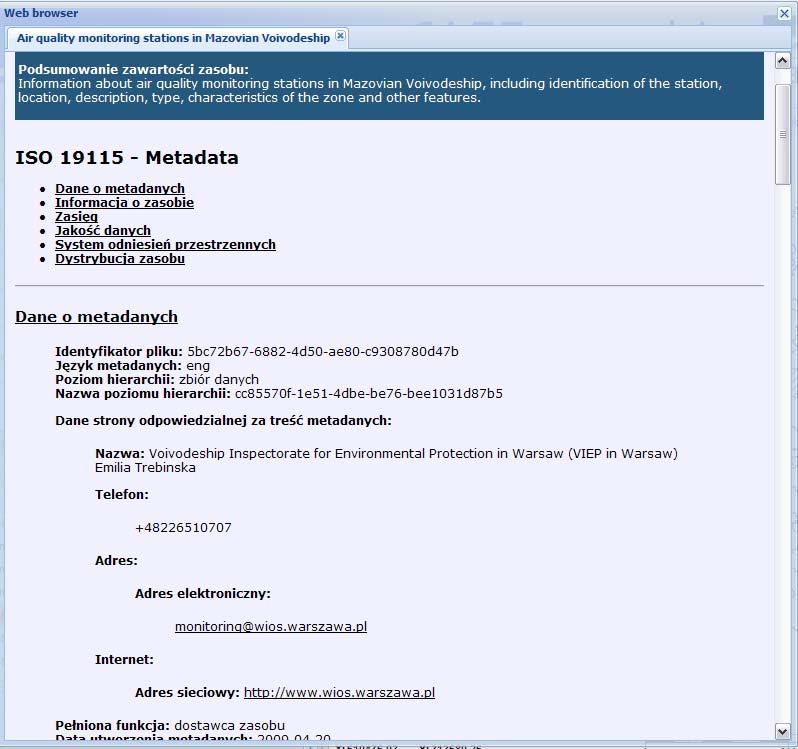
10 Metadata discovery example
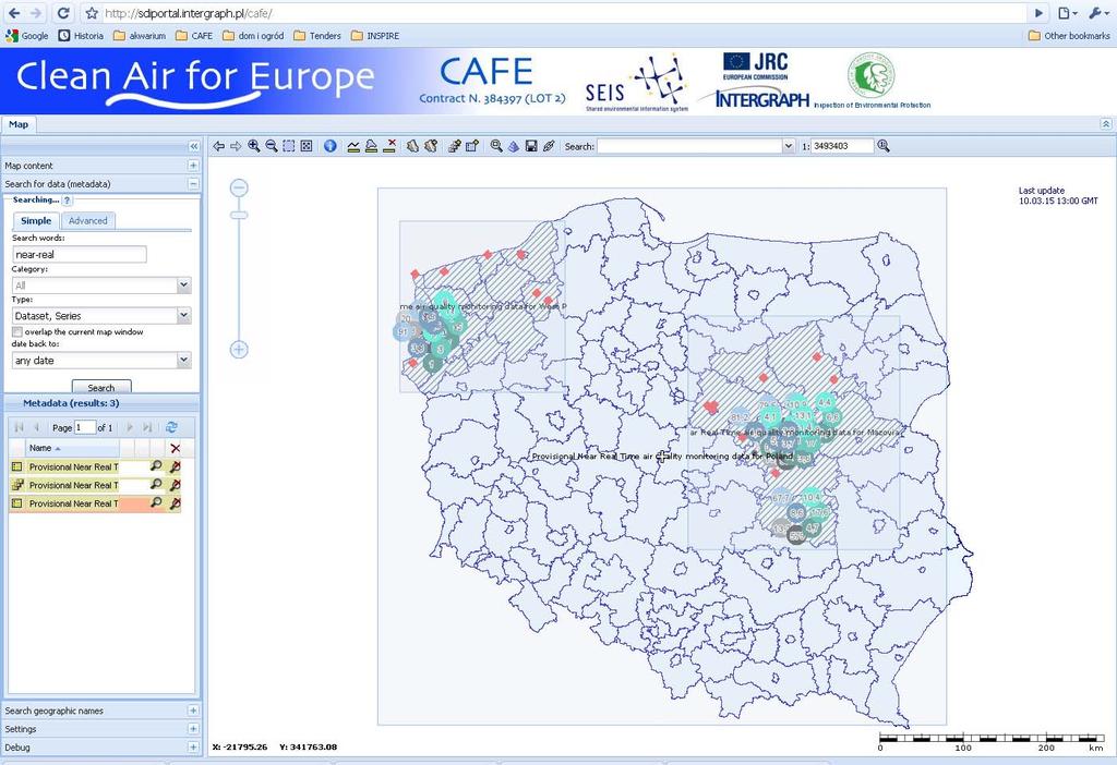
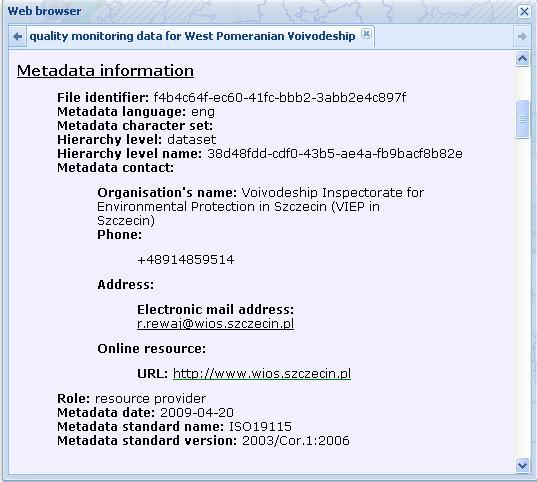
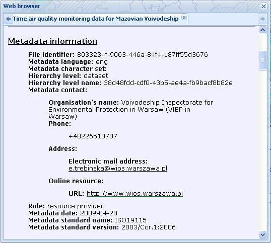
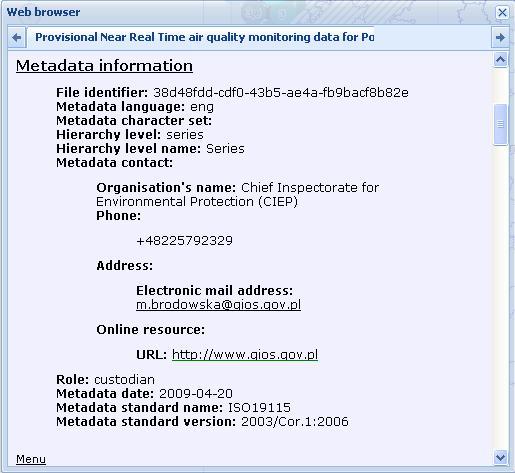
11

12 Data model specification for air quality data requirements CAFE requirements Draft CAFÉ Implementing Povisions (as of January 19, 2009) Requirements for scope of air quality information Technical requirements for air quality information exchange Requirements extracted from Airbase Data Dictionary INSPIRE requirements Recommended methodology for common model development Recommendations for INSPIRE data specifications Requirements of Generic Conceptual Model Requirements for Application schema encoding

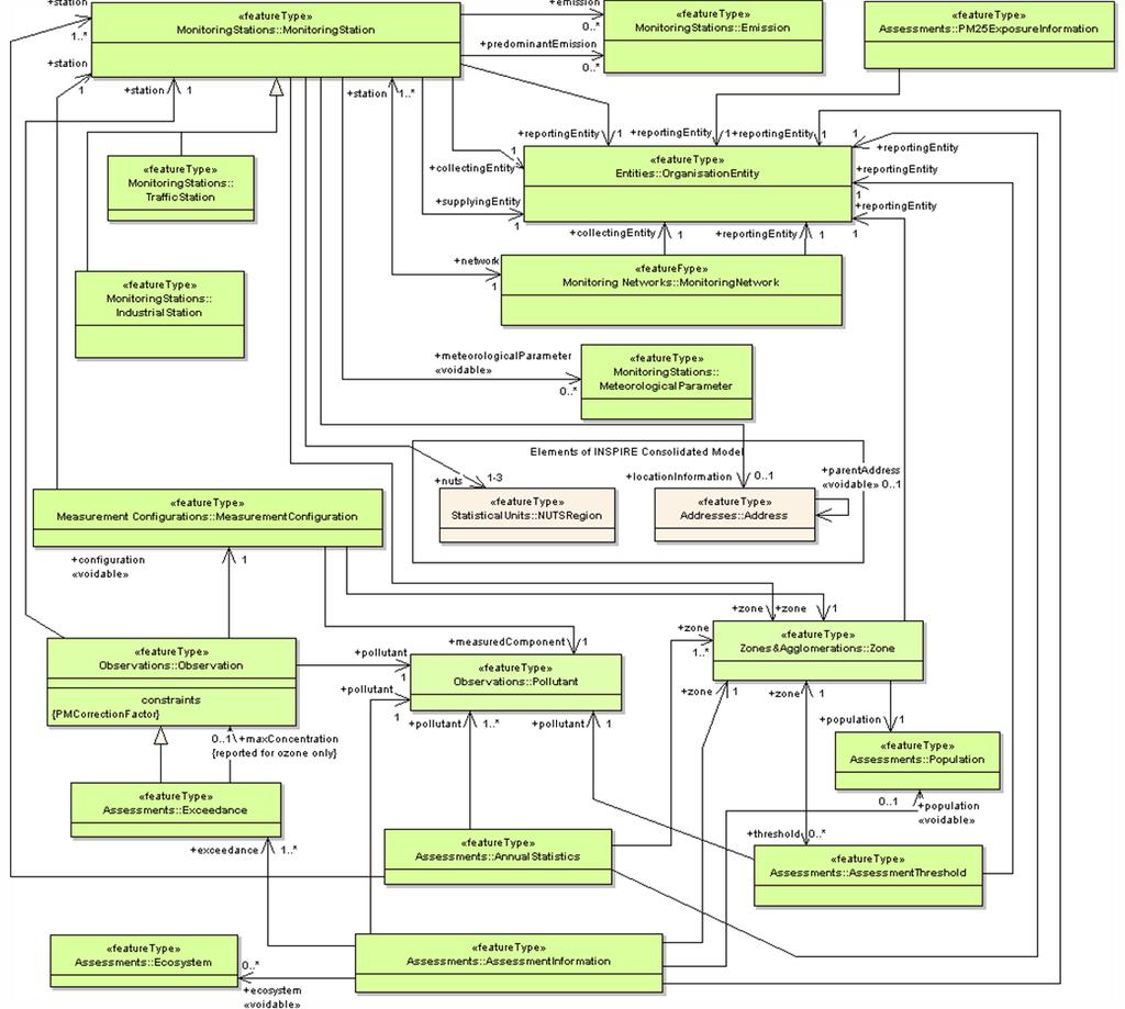
13 Model elements Feature types 18 Data Types 10 Code lists 38 16/3/2010 SEIS - CAFE Project final workshop - Brussels
14
15 Remoddeling process - workflow PHASE 1: PRELIMINARY PROCESSING OF PRODUCTION DATA DATA TRANSFER FILE FORMAT STEP 1: Input data model analysis STEP 2: Output data model analysis DATABASE SCHEMA PRODUCTION DATABASE STEP 3: Model mapping STEP 4: Definition of data processing rules DATA TRANSFER FILE STEP 5: Execution of processing rules PUBLICATION DATABASE DOWNLOAD SERVICE PHASE 2 ON THE FLY TRANSFORMATION OF PUBLICATION DATA Apply XSLT SEIS - CAFE Project final Define workshop XSLT - transformation Brussels transformation DATABASE SCHEMA GML APPLICATION SCHEMA AIR QUALITY 15
16 Model Mapping - example ORIGINAL DATA MODEL SEIS CAFE PILOT AIR QUALITY DATA MODEL FEATURE TYPE FEATURE ATTRIBUTE VALUE DOMAIN FEATURE TYPE FEATURE ATTRIBUTE VALUE DOMAIN Strefy nazwa strefy Datatype: Varchar2 Datatype: Zone zonename Minsize=1 CharacterString Maxsize=60 Strefy kod_strefy Datatype: Varchar2 Datatype: Zone zonecode Minsize=1 CharacterString Maxsize=60 Strefy zanieczyszczenia Datatype: Varchar2 Datatype: pollutant (foreign key to Zone Minsize=1 CharacterString Pollutant feature type) Maxsize=255 Strefy aglomeracja Datatype: Varchar2 Datatype: Zone zonetype Minsize=1 CharacterString Maxsize= 50 Strefy powierzchnia Datatype: Number Zone area Datatype: Number Strefy liczba_miesz Datatype: population (foreign key Datatype: Varchar2 Zone to Population feature Minsize=1 Number type) Maxsize= 255 Shp files Zone boundary source Datatype: (geospatial file/ LAU2 Zone geometry SDO_GEOMETRY list)
Using INSPIRE Services for Reporting and Exchange of Air Quality Information under CAFE Directive Test bed Results
 Using INSPIRE Services for Reporting and Exchange of Air Quality Information under CAFE Directive Test bed Results Alina Kmiecik, Dominik Kobus, Magdalena Bednarek, Piotr Krok, Anna Zamolska 26,6/2012,
Initial Operating Capability & The INSPIRE Community Geoportal
 INSPIRE Conference, Rotterdam, 15 19 June 2009 1 Infrastructure for Spatial Information in the European Community Initial Operating Capability & The INSPIRE Community Geoportal EC INSPIRE GEOPORTAL TEAM
GeoDCAT-AP Representing geographic metadata by using the "DCAT application profile for data portals in Europe"
 GeoDCAT-AP Representing geographic metadata by using the "DCAT application profile for data portals in Europe" Andrea Perego, Vlado Cetl, Anders Friis-Christensen, Michael Lutz, Lorena Hernandez Joint
The European Commission s science and knowledge service. Joint Research Centre
 The European Commission s science and knowledge service Joint Research Centre GeoDCAT-AP The story so far Andrea Perego, Antonio Rotundo, Lieven Raes GeoDCAT-AP Webinar 6 June 2018 What is GeoDCAT-AP Geospatial
Methodological approach for cross-theme harmonization of Polish spatial data sets the case study for the Annex I themes
 Methodological approach for cross-theme harmonization of Polish spatial data sets the case study for the Annex I themes Elżbieta Bielecka, Agnieszka Zwirowicz-Rutkowska, Alina Kmiecik, Marek Brylski, Magdalena
How to Create a European INSPIRE Compliant Data Specification. Anja Hopfstock, BKG (Germany) Morten Borrebæk, SK (Norway)
 Morten Borrebæk, SK (Norway)") How to Create a European INSPIRE Compliant Data Specification Anja Hopfstock, BKG (Germany) Morten Borrebæk, SK (Norway) ESDIN Key Goals Further the ambition of the European Commission to create a European
How to Create a European INSPIRE Compliant Data Specification Anja Hopfstock, BKG (Germany) Morten Borrebæk, SK (Norway) ESDIN Key Goals Further the ambition of the European Commission to create a European
Javier NOGUERAS-ISO 1, Manuel A. UREÑA-CÁMARA 2, Javier LACASTA 1, F. Javier ARIZA-LÓPEZ 2
 Checking the completeness and consistency of geographic metadata is not enough: evolution towards smart contracts for checking accuracy and correctness Javier NOGUERAS-ISO 1, Manuel A. UREÑA-CÁMARA 2,
Integration of INSPIRE & SDMX data infrastructures for the 2021 population and housing census
 Integration of INSPIRE & SDMX data infrastructures for the 2021 population and housing census Nadezhda VLAHOVA, Fabian BACH, Ekkehard PETRI *, Vlado CETL, Hannes REUTER European Commission (*ekkehard.petri@ec.europa.eu
The cadastral data and standards based on XML in Poland
 The cadastral data and standards based on XML in Poland Jarosław Bydłosz, Piotr Parzych AGH University of Science and Technology Cracow, Poland 1 XML XML Extensible Markup Language Extensible Markup Language
Use case 1 INSPIRE harmonization of existing Energy Performance Certificate datasets Phase 1
 The European Commission s science and knowledge service Joint Research Centre Use case 1 INSPIRE harmonization of existing Energy Performance Certificate datasets Phase 1 Giacomo Martirano (external consultant)
PortalU, a Tool to Support the Implementation of the Shared Environmental Information System (SEIS) in Germany
 in Germany") European conference of the Czech Presidency of the Council of the EU TOWARDS eenvironment Opportunities of SEIS and SISE: Integrating Environmental Knowledge in Europe http:/www.e-envi2009.org/proceedings/
European conference of the Czech Presidency of the Council of the EU TOWARDS eenvironment Opportunities of SEIS and SISE: Integrating Environmental Knowledge in Europe http:/www.e-envi2009.org/proceedings/
Spatial Data on the Web
 Spatial Data on the Web Tools and guidance for data providers The European Commission s science and knowledge service W3C Data on the Web Best Practices 35 W3C/OGC Spatial Data on the Web Best Practices
Automatic Creation of INSPIRE Meta-information from SWE Services
 S@NY Automatic Creation of INSPIRE Meta-information from SWE Services Désirée Hilbring, Fraunhofer IITB hilbring@iitb.fraunhofer.de Agile 2009 Challenges in Geospatial Data Harmonization, Hanover Copyright
Introduction to INSPIRE. Network Services
 Introduction to INSPIRE. Network Services European Commission Joint Research Centre Institute for Environment and Sustainability Digital Earth and Reference Data Unit www.jrc.ec.europa.eu Serving society
INSPIRE overview and possible applications for IED and E-PRTR e- Reporting Alexander Kotsev
 INSPIRE overview and possible applications for IED and E-PRTR e- Reporting Alexander Kotsev www.jrc.ec.europa.eu Serving society Stimulating innovation Supporting legislation The European data puzzle 24
Metadata of geographic information
 Metadata of geographic information Kai Koistinen Management of environmental data and information 4.10.2017 Topics Metadata of geographic information What is metadata? Metadata standards and recommendations
Compass INSPIRE Services. Compass INSPIRE Services. White Paper Compass Informatics Limited Block 8, Blackrock Business
 Compass INSPIRE Services White Paper 2010 Compass INSPIRE Services Compass Informatics Limited Block 8, Blackrock Business Park, Carysfort Avenue, Blackrock, County Dublin, Ireland Contact Us: +353 1 2104580
(Towards) A metadata model for atmospheric data resources
 A metadata model for atmospheric data resources") (Towards) A metadata model for atmospheric data resources Anne De Rudder and Jean-Christopher Lambert Belgian Institute for Space Aeronomy (IASB-BIRA), Brussels The context EU FP7 Ground-based atmospheric
(Towards) A metadata model for atmospheric data resources Anne De Rudder and Jean-Christopher Lambert Belgian Institute for Space Aeronomy (IASB-BIRA), Brussels The context EU FP7 Ground-based atmospheric
Open Geospatial Consortium
 Open Geospatial Consortium Date: 28-March-2011 Reference number of this document: 10-195 Editors: OGC Aviation Domain Working Group Requirements for Aviation Metadata Copyright 2011 Open Geospatial Consortium.
Reporting of modelled data under the AQD IPR for e-reporting
 Reporting of modelled data under the AQD IPR for e-reporting RETROSPECTIVE OF PILOT TESTING IN 2012 & MODELLING DATA Tony Bush 6 th pilot meeting Copenhagen 8-10 October 2012 Introduction Where does modelled
The UK Marine Environmental Data and Information Network MEDIN
 The UK Marine Environmental Data and Information Network MEDIN M. Charlesworth, R. Lowry, H. Freeman, J. Rapaport, B Seeley Content MEDIN - a brief overview for context Discovery Metadata Standard and
Draft meeting minutes
 Draft meeting minutes 6th meeting of the IPR Pilot Group Date & Time 8-10 October 2012, Copenhagen Location EEA, Copenhagen Attendees Representatives from the following IPR pilot countries: DE, DK, BE,
Schema transformations in mass data harmonization process. Yohann Ly 8/9 Octobre 2013 Marne la Vallée
 Schema transformations in mass data harmonization process Yohann Ly 8/9 Octobre 2013 Marne la Vallée Mass data harmonization process Problematic : Multiple data providers Multiple storage format Multiple
Umweltbundesamt. Masaryk University Laboratory on Geoinformatics and Cartography
 Co-funded by the community programme econtentplus GS SOIL METADATA Christian Ansorge Umweltbundesamt Tomáš Řezník Masaryk University Laboratory on Geoinformatics and Cartography GS Soil workshop, INSPIRE
IHO S-100 Framework. The Essence. WP / Task: Date: Author: hansc/dga Version: 0.6. Document name: IHO S-100 Framework-The Essence
 WP / Task: 4.4.1. Date: 2015-09-25 Author: hansc/dga Version: 0.6 Document name: IHO S-100 Framework-The Essence IHO S-100 Framework Version 0.6 The Essence Document information More recent versions of
This document is a preview generated by EVS
 TECHNICAL SPECIFICATION SPÉCIFICATION TECHNIQUE TECHNISCHE SPEZIFIKATION CEN ISO/TS 19139 November 2009 ICS 35.240.70 English Version Geographic information - Metadata - XML schema implementation (ISO/TS
GENeric European Sustainable Information Space for Environment.
 GENeric European Sustainable Information Space for Environment http://www.genesis-fp7.eu/ Outline Introduction The GENESIS FP7 project The GENESIS solution s architecture GENESIS experience with INSPIRE
INSPIRE & Environment Data in the EU
 INSPIRE & Environment Data in the EU Andrea Perego Research Data infrastructures for Environmental related Societal Challenges Workshop @ pre-rda P6 Workshops, Paris 22 September 2015 INSPIRE in a nutshell
Gower Street, London, WC1E 6BT UK Tel. +44 (0) Fax +44 (0) PB Wageningen, The Netherlands
 Fax +44 (0) PB Wageningen, The Netherlands") Automating Standards-Based Metadata Creation using Free and Open Source GIS Tools Claire Ellul 1, Nart Tamash 1, Feng Xian 1, John Stuiver 2, Patrick Rickles 1 1 Department of Civil, Environmental and
Automating Standards-Based Metadata Creation using Free and Open Source GIS Tools Claire Ellul 1, Nart Tamash 1, Feng Xian 1, John Stuiver 2, Patrick Rickles 1 1 Department of Civil, Environmental and
ISA Action 1.17: A Reusable INSPIRE Reference Platform (ARE3NA)
") ISA Action 1.17: A Reusable INSPIRE Reference Platform (ARE3NA) Expert contract supporting the Study on RDF and PIDs for INSPIRE Deliverable D.EC.3.2 RDF in INSPIRE Open issues, tools, and implications
ISA Action 1.17: A Reusable INSPIRE Reference Platform (ARE3NA) Expert contract supporting the Study on RDF and PIDs for INSPIRE Deliverable D.EC.3.2 RDF in INSPIRE Open issues, tools, and implications
Exploitation towards Thematic Communities, Training Framework and stakeholders involvement
 Exploitation towards Thematic Communities, Training Framework and stakeholders involvement Giorgio Saio GISIG eenvplus Workshop INSPIRE Conference, Florence (IT), 24 June 2013 Exploitation prospects eenvplus
Overview. Overview. Broadsheet for PNAMP Metadata Builder. Metadata Entity Set Information. Taurus Monitoring
 Overview Overview The Metadata Builder Tool aims to facilitate and encourage the development of metadata for aquatic monitoring data collected by government agencies and partners in the Pacific Northwest.
INSPIRE: The ESRI Vision. Tina Hahn, GIS Consultant, ESRI(UK) Miguel Paredes, GIS Consultant, ESRI(UK)
 Miguel Paredes, GIS Consultant, ESRI(UK)") INSPIRE: The ESRI Vision Tina Hahn, GIS Consultant, ESRI(UK) Miguel Paredes, GIS Consultant, ESRI(UK) Overview Who are we? Introduction to ESRI Inc. and ESRI(UK) Presenters ArcGIS The ESRI Solution to
INSPIRE: The ESRI Vision Tina Hahn, GIS Consultant, ESRI(UK) Miguel Paredes, GIS Consultant, ESRI(UK) Overview Who are we? Introduction to ESRI Inc. and ESRI(UK) Presenters ArcGIS The ESRI Solution to
Data and visualization
 Data and visualization Harry Lankreijer Joint ICOS Carbon Portal and EUROCOM Workshop 2016-06-21 ICOS Carbon Portal Lund University Jena inversion, Christian Rödenbeck; at CP webpage (https://www.icos-cp.eu/node/52)
INSPIRE status report
 INSPIRE Team INSPIRE Status report 29/10/2010 Page 1 of 7 INSPIRE status report Table of contents 1 INTRODUCTION... 1 2 INSPIRE STATUS... 2 2.1 BACKGROUND AND RATIONAL... 2 2.2 STAKEHOLDER PARTICIPATION...
SEXTANT 1. Purpose of the Application
 SEXTANT 1. Purpose of the Application Sextant has been used in the domains of Earth Observation and Environment by presenting its browsing and visualization capabilities using a number of link geospatial
SEIS. (Shared Environmental Information System) From concept to information services
 From concept to information services") SEIS (Shared Environmental Information System) From concept to information services Stefan Jensen EEA supported by Sheila Cryan and Jon Maidens GSDI 11, Rotterdam 19.6.2009 What is SEIS is about... Sharing
SEIS (Shared Environmental Information System) From concept to information services Stefan Jensen EEA supported by Sheila Cryan and Jon Maidens GSDI 11, Rotterdam 19.6.2009 What is SEIS is about... Sharing
AQD IPR pilot study programme on e-reporting
 AQD IPR pilot study programme on e-reporting A quick start guide working with the e-reporting schemata Tony Bush 4 th pilot meeting Copenhagen 15-16 March 2012 Introduction What to worry about first if
Rui Reis, Maria José Vale, Marcelo Ribeiro, Bruno Meneses Geospatial World Forum 2016, May 2016, Rotterdam
 LC change detection and planning indicators Rui Reis, Maria José Vale, Marcelo Ribeiro, Bruno Meneses Summary 1. 2. 3. 4. 5. 6. 7. 8. Introduction Pilot overview Data description Inspire data harmonization
Christian Ansorge 27th April CDDA webinar 27th April Linked Approach as reporting mechanism
 Christian Ansorge 27th April 2017 CDDA webinar 27th April 2017 Linked Approach as reporting mechanism Generic Linked Approach Scope Background and motivation for reporting reusing INSPIRE Introduction
Leveraging metadata standards in ArcGIS to support Interoperability. David Danko and Aleta Vienneau
 Leveraging metadata standards in ArcGIS to support Interoperability David Danko and Aleta Vienneau Leveraging Metadata Standards in ArcGIS for Interoperability Why metadata and metadata standards? Overview
From the INSPIRE Engine Room
 From the INSPIRE Engine Room Michael Lutz ENiiG Conference, Lisbon 9 November 2016 Joint Research Centre the European Commission's in-house science service The JRC's role in INSPIRE Support MS in implementation
DanubeGIS User Manual Document number: Version: 1 Date: 11-Nov-2016
 DanubeGIS User Manual Document number: Version: 1 Date: 11-Nov-2016 Imprint Published by: ICPDR International Commission for the Protection of the Danube River ICPDR 2016 Contact ICPDR Secretariat Vienna
Metadata for Data Discovery: The NERC Data Catalogue Service. Steve Donegan
 Metadata for Data Discovery: The NERC Data Catalogue Service Steve Donegan Introduction NERC, Science and Data Centres NERC Discovery Metadata The Data Catalogue Service NERC Data Services Case study:
Commission Action Plan on Compliance and Governance
 Expert Group "Greening the European Semester / Environmental Implementation Review" 23 January 2018, Brussels Commission Action Plan on Compliance and Governance KEY FINDINGS OF PREPARATORY STAGE EIR
Training Framework LINKVIT
 Geographical Infomation Systems International Group Training Framework LINKVIT G. Saio GISIG g.saio@gisig.it 1 www.linkvit.eu Project aims 2 LINKVIT deals with Digital Competence as defined in the Key
SII Law Organization Coordination activities Examples of good practices Education Technical matters Success stories Challenges
 SII Law Organization Coordination activities Examples of good practices Education Technical matters Success stories Challenges INSPIRE transposed by the legal act on Spatial Information Infrastructure
The coastal data in the regional and national territorial data repertory. Genova 24 Aprile 2012 Anna Cerrato Regione Liguria
 The coastal data in the regional and national territorial data repertory Genova 24 Aprile 2012 Anna Cerrato Regione Liguria www.rndt.gov.it Experience from data providers in using transformation tools
Web apps for INSPIRE: the ELISE Energy pilot example
 Web apps for INSPIRE: the ELISE Energy pilot example 6 September 2017 Authors: Daniele Francioli Giacomo Martirano Maria Teresa Borzacchiello Francesco Pignatelli Outline Overview of the ELISE Energy Pilot
Spatial Data on the Web
 Spatial Data on the Web Tools and guidance for data providers Clemens Portele, Andreas Zahnen, Michael Lutz, Alexander Kotsev The European Commission s science and knowledge service Joint Research Centre
Croatian NSDI Metadata Profile
 Croatian NSDI Metadata Profile Prof. dr. sc. Željko Hećimović State Geodetic Administration zeljko.hecimovic@dgu.hr infonipp@dgu.hr http:// INSPIRATION workshop 21st 22nd Nov. CONTENT: Introduction Metadata
INSPIRE Geoportal Rich user experience across member states services
 INSPIRE Geoportal Rich user experience across member states services developed under a contract with the EC (JRC) Diomede ILLUZZI 1 Nicola LUNANOVA 1 Torsten FRIEBE 2 1 Planetek Italia s.r.l Via Masaua
Study and guidelines on Geospatial Linked Data as part of ISA Action 1.17 Resource Description Framework
 DG Joint Research Center Study and guidelines on Geospatial Linked Data as part of ISA Action 1.17 Resource Description Framework 6 th of May 2014 Danny Vandenbroucke Diederik Tirry Agenda 1 Introduction
GeoDCAT-AP. Working Group Meeting 1. Tuesday 31 March 2015, 14:00-16:00 CET (UTC+2)
") GeoDCAT-AP Working Group Meeting 1 Tuesday 31 March 2015, 14:00-16:00 CET (UTC+2) How to enter the Virtual Meeting Room? See https://joinup.ec.europa.eu/node/139765 1. Web connection: http://ec-wacs.adobeconnect.com/geodcat-ap/
GeoDCAT-AP Working Group Meeting 1 Tuesday 31 March 2015, 14:00-16:00 CET (UTC+2) How to enter the Virtual Meeting Room? See https://joinup.ec.europa.eu/node/139765 1. Web connection: http://ec-wacs.adobeconnect.com/geodcat-ap/
HUMBOLDT Application Scenario: Protected Areas
 CC by Erlend Schei Copyright by Kecko Copyright by Michael Bezzina CC by Gunnar Ries Copyright by Michael Bezzina Copyright by Michael Bezzina Copyright by Michael Bezzina CC by fs999 CC by Jordan Nielsen
Note: For the creation of an application schema several software tools can be used. Enterprise Architect is one of the tools that can be used.
 1.0 Definitions 1.1 Application Schema - An application schema is a fundamental element of any S-100 based product specification. The application schema serves two purposes: - It achieves a common and
Guidelines for the encoding of spatial data
 INSPIRE Infrastructure for Spatial Information in Europe Guidelines for the encoding of spatial data Title Status Creator Date 2012-06-15 Subject Publisher Type Description Contributor Format Source Rights
Standards, standardisation & INSPIRE Status, issues, opportunities
 Standards, standardisation & INSPIRE Status, issues, opportunities INSPIRE Coordination Team 6 th MIG meeting, 13-14 June 2017 Joint Research Centre The European Commission's science and knowledge service
INSPIRE WS2 METADATA: Describing GeoSpatial Data
 WS2 METADATA: Describing GeoSpatial Data Susana Fontano Planning General concepts about metadata The use of standards Items about the creation of metadata Software How to create metadata The ISO19115 Standard
Draft Agenda. 1 st ENI SEIS II South Support Mechanism Regional Workshop on Infrastructure and Data Management. Introduction
 1 st ENI SEIS II South Support Mechanism Regional Workshop on Infrastructure and Data Management Introduction 4 5 October 2018, Rome, Italy Venue: H10 Roma Città Via Amedeo Avogadro, 35 00146 Rome Draft
INSPIRE Conference Automatic metadata generation for the Web geo-resources
 INSPIRE Conference 2011 Automatic metadata generation for the Web geo-resources B. Borjas, A.J. Florczyk, F.J. López-Pellicer, J. Nogueras-Iso, F.J. Zarazaga-Soria June 28, 2011. Edinburgh Advanced Information
The European Soil Data Centre, the European Soil Bureau Network and INSPIRE Data Specifications for Soil
 The European Soil Data Centre, the European Soil Bureau Network and INSPIRE Data Specifications for Soil Marc Van Liedekerke, Panos Panagos, Luca Montanarella Land Management and Natural Harzards Unit
INTERNATIONAL HYDROGRAPHIC ORGANIZATION
 INTERNATIONAL HYDROGRAPHIC ORGANIZATION IHO GUIDELINE STANDARD FOR CREATING S-100 PRODUCT SPECIFICATIONS PART A Version 0.1 2018-01-31 Special Publication No. S-??? Guideline for Creating an S-100 Product
Reducing Consumer Uncertainty Towards a Vocabulary for User-centric Geospatial Metadata
 Meeting Host Supporting Partner Meeting Sponsors Reducing Consumer Uncertainty Towards a Vocabulary for User-centric Geospatial Metadata 105th OGC Technical Committee Palmerston North, New Zealand Dr.
Download Service Implementing Rule and Technical Guidance
 Download and Transformation Draft Implementing Rules Presentation for INSPIRE Initiatives Download Service Implementing Rule and Technical Guidance Olaf Østensen Statens kartverk Norwegian Mapping Authority
Reducing Consumer Uncertainty
 Spatial Analytics Reducing Consumer Uncertainty Towards an Ontology for Geospatial User-centric Metadata Introduction Cooperative Research Centre for Spatial Information (CRCSI) in Australia Communicate
8 Dataset-level metadata
 8 Dataset-level metadata This section specifies dataset-level metadata elements, which should be used for documenting metadata for a complete dataset or dataset series. NOTE Metadata can also be reported
Energy Industry Profile An Update from the Metadata Work Group
 Energy Industry Profile An Update from the Metadata Work Group May 1, 2012 PUG Conference 2012 Houston, Texas Metadata Work Group Outline Metadata Initiative Background / EIP Overview 2012 Release of EIP
MY DEWETRA IPAFLOODS REPORT
 Grant Contract N. ECHO/SUB/2014/692292 Programme for Prevention, Preparedness and Response to Floods in the Western Balkans and Turkey IPA FLOODS Capacity Building Activities 2016 MY DEWETRA IPAFLOODS
INSPIRE & Linked Data: Bridging the Gap Part II: Tools for linked INSPIRE data
 Making the Web an Exploratory Place for Geospatial Knowledge INSPIRE & Linked Data: Bridging the Gap Part II: Tools for linked INSPIRE data Michalis Alexakis Spiros Athanasiou Nikos Georgomanolis Giorgos
ARCHITECTURE OF SPATIAL DATA INFRASTRUCTURE (SDI) (DRAFT)
 (DRAFT)") ARCHITECTURE OF SPATIAL DATA INFRASTRUCTURE (SDI) (DRAFT) Author: Carlo Cipolloni September 20, 2018 Version 1.0 A SDI platform to support the SEIS in the ENP South region Introduction Based on the Contribution
ARCHITECTURE OF SPATIAL DATA INFRASTRUCTURE (SDI) (DRAFT) Author: Carlo Cipolloni September 20, 2018 Version 1.0 A SDI platform to support the SEIS in the ENP South region Introduction Based on the Contribution
Quality control service for Inspire data
 Quality control service for Inspire data INSPIRE Conference 2014 Aalborg Anders Foureaux Process Manager Data feeds Data hosting Environmental Informations Systems Unit Reasearch and Assessment Department
Knowledge Inventory for hydrogeology research
 Knowledge Inventory for hydrogeology research This project has received funding from the European Union s Horizon 2020 research and innovation programme under grant agreement No 642047. REDIAM Environmental
Guidelines for the encoding of spatial data
 INSPIRE Infrastructure for Spatial Information in Europe Guidelines for the encoding of spatial data Title D2.7: Guidelines for the encoding of spatial data, Version 3.1 Creator INSPIRE Drafting Team "Data
Consolidation Team INSPIRE Annex I data specifications testing Call for Participation
 INSPIRE Infrastructure for Spatial Information in Europe Technical documents Consolidation Team INSPIRE Annex I data specifications testing Call for Participation Title INSPIRE Annex I data specifications
Addressing the needs of INSPIRE: The Challenges of improving Interoperability within the European Union
 Addressing the needs of INSPIRE: The Challenges of improving Interoperability within the European Union Andrew Coote Facilitator, Addresses Thematic Working Group andrew.coote@consultingwhere.com Disclaimer
This document is a preview generated by EVS
 TECHNICAL REPORT RAPPORT TECHNIQUE TECHNISCHER BERICHT CEN/TR 15449-5 April 2015 ICS 07.040; 35.240.70 English Version Geographic information - Spatial data infrastructures - Part 5: Validation and testing
Draft INSPIRE Implementing Rule on Metadata
 Document: D/GIS/97/EN Original Meeting of the Working Party "Geographical Information Systems for Statistics" Joint meeting with National Statistical Offices and National Mapping Agencies Luxembourg, March
The French Geoportal : linking discovery and view network services. INSPIRE Conference Krakow
 The French Geoportal : linking discovery and view network services ( BRGM ) D.Richard (IGN) F. Robida Context of the French Geoportal The governance mechanism Transversal organisation based on the Ministry
This document is a preview generated by EVS
 TECHNICAL SPECIFICATION ISO/TS 19163-1 First edition 2016-01-15 Geographic information Content components and encoding rules for imagery and gridded data Part 1: Content model Information géographique
Testing - an essential aspect of establishing an SDI
 Testing - an essential aspect of establishing an SDI Clemens Portele, Anders Östman, Michael Koutroumpas, Xin He, Janne Kovanen, Markus Schneider, Andriani Skopeliti INSPIRE Conference 2011 30 June 2011
The MED Biodiversity Protection Know ledge Platform
 The MED Biodiversity Protection Know ledge Platform Em anuele Mancosu/Sonsoles San Rom án Europ ean Topic Centre University of Malaga (ETC-UMA) Brid g in g th e Scie n ce -Practice-Policy Ga p in Me d
Part 1: Content model
 Provläsningsexemplar / Preview TECHNICAL SPECIFICATION ISO/TS 19163-1 First edition 2016-01-15 Geographic information Content components and encoding rules for imagery and gridded data Part 1: Content
The Jülich WCS interface for emissions, model products, and model evaluation
 The Jülich WCS interface for emissions, model products, and model evaluation Martin G. Schultz, M. Decker, S. Lührs, S. Schröder, O. Stein, S. Waychal IEK-8, Forschungszentrum Jülich, Germany PART1: AIR
INSPIRE Coverage Types
 INSPIRE Infrastructure for Spatial Information in Europe INSPIRE Coverage Types Title Status Creator Date 2012-06-15 Subject Publisher Type Description Contributor Format Source Rights Identifier Language
Transboundary data interoperability for Maritime Spatial Planning. Yuji KATO
 Transboundary data interoperability for Maritime Spatial Planning Yuji KATO CONTEXT THE MARITIME SPATIAL PLANNING DIRECTIVE DIRECTIVE 2014/89/EU establishing a framework for Maritime Spatial Planning (MSP)
Infrastructure for Spatial Information in Europe. Proposed action for update of MIWP: Alternative encodings for INSPIRE data
 INSPIRE Infrastructure for Spatial Information in Europe Proposed action for update of MIWP: Alternative encodings for INSPIRE data Type Creator MIWP Action fiche DG ENV Date/status/version 20/11/2017
INSPIRE tools What's new?
 INSPIRE tools What's new? Michael Lutz INSPIRE Conference, Antwerp 18 September 2018 Joint Research Centre The European Commission s science and knowledge service INSPIRE reference validator Why a reference
Uniform Resource Management
 IST-Africa 2008 Conference Proceedings Paul Cunningham and Miriam Cunningham (Eds) IIMC International Information Management Corporation, 2008 ISBN: 978-1-905824-07-6 Uniform Resource Management Karel
Croatian national metadata profile
 Croatian national metadata profile Dr. sc. Željko Hećimović State Geodetic Administration, Zagreb zeljko.hecimovic@dgu.hr CONTENT: Introduction Croatian national metadata profile Elements of the Croatian
Increasing dataset quality metadata presence: Quality focused metadata editor and catalogue queriables.
 Increasing dataset quality metadata presence: Quality focused metadata editor and catalogue queriables. Alaitz Zabala (UAB), Joan Masó (CREAF), Lucy Bastin (ASTON), Fabrizio Papeschi (CNR), Eva Sevillano
Geographic Information Fundamentals Overview
 CEN TC 287 Date: 1998-07 CR 287002:1998 CEN TC 287 Secretariat: AFNOR Geographic Information Fundamentals Overview Geoinformation Übersicht Information géographique Vue d'ensemble ICS: Descriptors: Document
Evolution of INSPIRE interoperability solutions for e-government
 Evolution of INSPIRE interoperability solutions for e-government INSPIRE Implementation State-of-Play 26/05/2015 Robin S. Smith www.jrc.ec.europa.eu Serving society Stimulating innovation Supporting legislation
Australian Standard. Information and documentation Records management processes Metadata for records. Part 1: Principles
 AS ISO 23081.1 2006 ISO 23081-1:2006 AS ISO 23081.1 2006 Australian Standard Information and documentation Records management processes Metadata for records Part 1: Principles This Australian Standard
Interoperability & Metadata
 Interoperability & Metadata David Danko Project Leader ISO 19115 ISO 19139 Editor ISO 19115-2 ddanko@esri.com Be able to: Interoperability the ability of two or more systems or components to exchange information
Detailed analysis + Integration plan
 Outline Integration methodology Detailed analysis + Integration plan Conclusions 2 Outline Integration methodology Detailed analysis + Integration plan Conclusions 3 EULF-ISA Integration: methodology Phase
Workshop 4.4: Lessons Learned and Best Practices from GI-SDI Projects II
 Workshop 4.4: Lessons Learned and Best Practices from GI-SDI Projects II María Cabello EURADIN technical coordinator On behalf of the consortium mcabello@tracasa.es euradin@navarra.es Scope E-Content Plus
Application of the Catalogue and Validator tools in the context of Inspire Alberto Belussi, Jody Marca, Mauro Negri, Giuseppe Pelagatti
 Application of the Catalogue and Validator tools in the context of Inspire Alberto Belussi, Jody Marca, Mauro Negri, Giuseppe Pelagatti Politecnico di Milano giuseppe.pelagatti@polimi.it spatialdbgroup.polimi.it
Introduction
 Introduction EuropeanaConnect All-Staff Meeting Berlin, May 10 12, 2010 Welcome to the All-Staff Meeting! Introduction This is a quite big meeting. This is the end of successful project year Project established
The Spatial Data Standards for Facilities, Infrastructure and Environment (SDSFIE) Quality and Raster Standards
 Quality and Raster Standards") The Spatial Data Standards for Facilities, Infrastructure and Environment (SDSFIE) Quality and Raster Standards Ms. Karen Barnhouse DISDI Program Support OASD(EI&E) June 29, 2016 Agenda What is the SDSFIE
The Spatial Data Standards for Facilities, Infrastructure and Environment (SDSFIE) Quality and Raster Standards Ms. Karen Barnhouse DISDI Program Support OASD(EI&E) June 29, 2016 Agenda What is the SDSFIE