MY DEWETRA IPAFLOODS REPORT
|
|
|
- William Rodgers
- 5 years ago
- Views:
Transcription


1 Grant Contract N. ECHO/SUB/2014/ Programme for Prevention, Preparedness and Response to Floods in the Western Balkans and Turkey IPA FLOODS Capacity Building Activities 2016 MY DEWETRA IPAFLOODS REPORT Prepared by: Verified by : Stefania Traverso, Laura Rossello, Guido Biondi Marco Massabo 20 th February 2017
2 Glossary Introduction Technical features of the platform Description of My DEWETRA IPAFLOODS applications... 4 Dewetra FloodCAT... 9 Geonode ESRI Geoportal Server for Metadata Configuration tool Administrative tool WIKI manuals Kumalè See KMS ANNEX: Manual for publishing data on My DEWETRA IPAFLOODS for administrators APSFR CIMA CSW EUFD EUWFD FH&FRM FRMP ICPD INSPIRE OGC PFRA SSO WISE Glossary Areas with Potential Significant Flood Risk Environmental Monitoring International Centre Catalog Services for the Web European Union Floods Directive European Union Water Framework Directive Flood Hazard and Flood Risk Maps Flood Risk Management Plans Italian Civil Protection Department Infrastructure for Spatial Information in Europe Open Geospatial Consortium Preliminary Flood Risk Assessment Single Sign-on Water Information System for Europe 2 P a g e
.")
3 1. Introduction This report is compiled in order to provide a clear vision of the scope, the agreements and the technical capacity of the platform My Dewetra IPAFLOODS, developed within the IPAFLOODS project and released officially on 31 st December 2016 at the closing of Lot 1, in charge of IPA FLOODS component on capacity building for EU FLOODS Directive approximation (EUFD NFP). My Dewetra IPAFLOODS is the Flood Risk Information System of the project according to Sub-Work-package 2.1. The entry page can be accessed at the link ipafloods.mydewetra.org as shown in Figure 1. Figure 1 It is a customization of MyDewetra, owned by the Italian Department of Civil Protection, developed by CIMA Research Foundation with open source technologies and compliant with the most common and widespread European and International standards. This IT infrastructure has been provided in kind to Beneficiaries countries within the project IPA FLOODS by CIMA Foundation and ICPD, and will be maintained by CIMA Foundation for long time after the end of the project as a mean to facilitate the capacity of Beneficiaries in the collection and sharing of geospatial information needed for Preliminary Flood Risk Assessment and Flood Hazard and Flood Risk Mapping. CIMA Foundation will grant for the same time a remote assistance to the publication of data on the platform and to its comprehension. The Capacity Building Activities developed during 2016 in the Beneficiaries countries registered the participation of officers from many institutions involved in the implementation and harmonization of EUFD to trainings and presentations of the beta version of the present platform. 3 P a g e
4 This document is produced as a guide for a complete and updated view of the platform and its applications and usage. Moreover in the annex the manual for publishing data is provided for the expert users who will be in charge of publishing/cataloguing data and/or will be local administrators in the Beneficiary. 2. Technical features of the platform My Dewetra IPAFLOODS is a portal protected by a secure SSO system that includes all the single applications dedicated to the specific activity as previously described. It is developed as a 2.0 Web Application and uses the most cutting edge technologies available; it is a RESTful application coded in python on the server side with a pure HTML 5.0/CSS client developed with AngularJS Open Source Framework. Under My Dewetra IPAFLOODS the user can access to the main DEWETRA 2.0 application that implements all the well-known OGC standards like WxS for data sharing and CSW for catalogues. With a completely renewed user interface, with native support also for mobile device, DEWETRA 2.0 relies on a layers-tag system to let the user access the required data in a quick and efficent way. On the server side the system relies on Dewetra Data Server technology, assuring the full compatibility with all existing data and making quick and easy the support to any other new data that has to be added. The acquisition systems and publishing engine has been strongly optimized making the whole system stunning fast and responsive. 3. Description of My DEWETRA IPAFLOODS applications The platform is cloud-based and designed with different modules (Figure 2) variously accessible through a policy on profiles: Geonode has been introduced as web-based application for uploading data; Esri Geoportal Server has to be intended as the open source tool oriented to the metadata management; two applications designed by CIMA Foundation and ICPD have been thought as the core elements of the system: Dewetra 2.0, customized here to be only a surfer of geospatial information implemented according to INSPIRE Data Themes in the access to data via tags and according to EUFD components accessing data with the logic of folders; FloodCAT, built under specific reporting schema for EUFD so to populate flood catalogues for recording and sharing data on historical floods, their consequences and impacts to human health, economic activity, environment and cultural heritage. 4 P a g e

5 Figure 2 Other five additional applications have been customized to support specific needs of the platform: a wiki manual provides general information to accessing data in the platform; a microblog named Kumale provides an environment to chat among circles of users; SEE.KMS is a library containing material on Disaster Risk Reduction from see.kms project of the UN Office for Disaster Risk Reduction (UNISDR) hosted by Disaster Preparedness and Prevention Initiative SEE; the Layer Configurator is the application needed to configure the way layers appears on Dewetra 2.0; the Administrator- Profile manager provides settings for users and circles. The link to all these applications can be found in the next Figure 3. 5 P a g e

6 Figure 3 Dewetra 2 Dewetra 2.0 is the evolution of the former integrated system Dewetra owned by the Italian Department of Civil Protection and developed by CIMA Research Foundation, operational at the Central Functional Centre of the National Civil Protection Department (DPC) c/o Prime Minister's Office since 2008, for the forecasting, monitoring and real-time surveillance of all the environmental risks. The application in its complete version can provide, through a graphical interface, high-resolution and continuously updated information, allowing the user to monitor weather events, to build detailed risk scenarios and evaluate the potential impact of phenomena on communities and infrastructure. Dewetra 2.0 allows each computer connected to the Internet the use of the integrated data, regardless the provider. The application manages, in fact, both the data provided by the National System of Functional Centres and the territorial and geospatial ones published as WMS services by other platforms. Dewetra 2.0 is able to load and display geo-referenced static and dynamic layers, and offers interactive tools and features for the analysis of ongoing and past events. Dewetra allows the collection and systematization 6 P a g e

 proposes a classification for each country following the categories of the EUFD regarding the three steps: Preliminary Flood Risk Assessment,")
7 of various kind of data, automatically or manually recorded and produces maps with value added elaborations. IN IPA FLOODS only the static layer surfer component has been implemented. The static layers can be choosen and loaded selecting between two different modes, Tag and Folder. By default the system proposes the tag mode that has been organized following the INSPIRE Themes Data- Specifications. Figure 4 The folder mode (Figure 5) proposes a classification for each country following the categories of the EUFD regarding the three steps: Preliminary Flood Risk Assessment, Flood Hazard and Risk Maps, Flood Risk Management Plans, and components typical for each step. A detailed example is reported in Figure 6. 7 P a g e


. An example is given in Figure 7.")
8 Figure 5 Figure 6 The platform includes a web-portal to visualize data from different sources and will ensure interoperability with already existing web-services as well as with the EU Water Information System,, and complies with main relevant international standards (e.g. EU INSPIRE Directive ). An example is given in Figure 7. 8 P a g e

9 Figure 7 The system has been designed to facilitate usage and sharing of spatial data on flood risk and to enhance the cooperation at National and Regional level among institutions, agencies and experts. The adoption of similar procedures, tools and terms could be the starting point towards the sharing of knowledge and data. One of the goals of the system is to create a specific environment for various actors in which spatial data from different users and countries can reach an effective utilization towards a full flood risk information system. FloodCAT The Italian government has established by law (a Directive of the President of the Council of Ministries, Dir.P.C.M. 49/2015) that the Civil Protection Department makes available to Regions and River Basin Authorities (FD Competent Authorities) a web-gis platform, named FloodCat, that fulfills the function of catalogue of flood events and, therefore, should be used to address the mentioned requirements of the FD. Therefore, in Italy FloodCat is the official technological platform for reporting historical and potential future floods according to the EU Floods Directive. Based on its specific architecture and in accordance to the Floods Reporting Guidance, for each significant flood the following data and information should be recorded: location (name of locality, river basin, subbasin and/or coastal area or other areas associated with past floods); category of flood (past flood or 9 P a g e
; probability of flood event (frequency, recurrence); date of")

10 Programme for Prevention, Preparedness and Response to Floods in the Western Balkans and Turkey - IPA FLOODS potential future flood); type of flood; extent (area of land inundated, or length of river stretches or coasts); probability of flood event (frequency, recurrence); date of commencement and duration (days) for each flood; type and degree of adverse consequences for: 1. human health; 2. environment; 3. cultural heritage; 4. economic activity plus other relevant information. Screenshots are given in the subsequent Figure 8 and Figure 9. Figure 8 Figure 9 10 P a g e


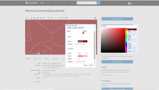
11 Geonode For IPA FLOODS project on the cloud space a specific installation of Geonode has been created. The manuals can be found on the website of Geonode developers at The appearance of the application is shown in the Figure 10 and Figure 11. Figure 10 Figure 11 ESRI Geoportal Server for Metadata The metadata manager selected is an open source application developed by ESRI where it is possible to create metadata forms for registering contents of the catalog of layers. Documentation is available at and a screenshot with the appearance of the application is shown in Figure P a g e


12 Figure 12 Configuration tool The configuration tool is the application needed to configure the way layers appears on Dewetra 2.0 and an example is shown in the next Figure 13. Figure P a g e

13 Administrative tool The Administrator- Profile manager provides settings for users and circles according to: Figure 14 WIKI manuals The support to the usage of the content of the platform is provided through a wiki environment, as shown in Figure 15. Figure 15 Kumalè KUMALE is a social application available as an export blog and common sharing platform to facilitate the communications between all the involved stakeholders during the normal work and during emergencies (Figure 16). Figure P a g e
 hosted by DPPI SEE.")
14 See KMS The link of the platform directly connects to the website where see.kms is a project of the UN Office for Disaster Risk Reduction (UNISDR) hosted by DPPI SEE. The content is thought as an useful library on DRR. Figure P a g e


15 ANNEX: Manual for publishing data on My DEWETRA IPAFLOODS for administrators UPLOADING LAYERS ON GEONODE Select language: Fill credits to access: 15 P a g e

16 Explore layers: Upload layers: Select layers: 16 P a g e


17 Execute upload: Manage layers: 17 P a g e


18 Manage styles: 18 P a g e

19 Layer configuration for Dewetra Three possibilities for the customization to Dewetra: Publish a new layer, Edit layer, Remove layer TO PUBLISH: select wms service where the layer has been published (es. Geonode service ) and the layer itself. 19 P a g e

; layer groups:")
20 The layer is now ready for publication; to characterize the layer it is necessary to fill out some fields before saving f (the required fields have an asterisk). Following is a brief description: name: the name that will appear on Dewetra; description: the description displayed on Dewetra; metadata url: any link to metadata; icon: the icon type; WMS service: the wms selected service; id: the unique id of the layer, is the name with which the layer was saved geonode; bounding box: the coordinates to which you want to refer to this layer (layer to zoom); layer type: select the type from the drop down menu or possibly add a new one; layer tags: keywords that characterize the layer (drop-down menu or the possibility of adding new tags); layer groups: the group to which you want to bind the layers (dropdown menu); layer path: the path to the folder menu that you want to assign to the layer (drop-down menu or the possibility of adding new locations); layer category: 3 categories are available, a standard layer select "static". Fill-in the fields of interest and click "save" button to end the procedure. 20 P a g e
21 Like the publishing process, the steps to change a layer need to select the files of interest and compilations of the same fields described above. These changes relate to the name, the type of route, tags and icons to characterize the layer on Dewetra. If you want to change the style you must go back to Geonode. The last window allows the elimination of layers from Dewetra catalog. 21 P a g e
 http://ipafloods.mydewetra.org 1 My Dewetra IPA FLOODS FLOOD RISK Information System Support the Approximation of EU Floods Directive Compliancy with International standards (INSPIRE, OGC) and protocols
INSPIRE: ready for landing?
 INSPIRE: ready for landing? Prof. Bernardo De Bernardinis President ISPRA Italian National Institute for Environmental Protection and Research INSPIRE 2013 Conference Opening Plenary, 25 th June 2013 Network
DATA MODELS FOR MACHU. Legislation CONCEPT
 DATA MODELS FOR MACHU Legislation CONCEPT 1 November 2016 Content 1. WHY USE MACHU DATA MODELS?... 3 2. FORMAT CHARACTERISTICS... 4 3. DATA MODEL DESCRIPTION OF THE LEGISLATION LAYER... 5 4 METADATA FORMATS...
Basic Principles of MedWIS - WISE interoperability
 Co-ordination committee seminar of the national focal points Basic Principles of MedWIS - WISE interoperability Eduardo García ADASA Sistemas Nice - France Agenda WISE vs MedWIS WISE WISE DS WISE vs WISE
DanubeGIS User Manual Document number: Version: 1 Date: 11-Nov-2016
 DanubeGIS User Manual Document number: Version: 1 Date: 11-Nov-2016 Imprint Published by: ICPDR International Commission for the Protection of the Danube River ICPDR 2016 Contact ICPDR Secretariat Vienna
INFORMATION NOTE. United Nations/Germany International Conference
 INFORMATION NOTE United Nations/Germany International Conference Earth Observation: Global solutions for the challenges of sustainable development in societies at risk Organized by The United Nations Office
SEXTANT 1. Purpose of the Application
 SEXTANT 1. Purpose of the Application Sextant has been used in the domains of Earth Observation and Environment by presenting its browsing and visualization capabilities using a number of link geospatial
Initial Operating Capability & The INSPIRE Community Geoportal
 INSPIRE Conference, Rotterdam, 15 19 June 2009 1 Infrastructure for Spatial Information in the European Community Initial Operating Capability & The INSPIRE Community Geoportal EC INSPIRE GEOPORTAL TEAM
INSPIRE overview and possible applications for IED and E-PRTR e- Reporting Alexander Kotsev
 INSPIRE overview and possible applications for IED and E-PRTR e- Reporting Alexander Kotsev www.jrc.ec.europa.eu Serving society Stimulating innovation Supporting legislation The European data puzzle 24
INSPIRE status report
 INSPIRE Team INSPIRE Status report 29/10/2010 Page 1 of 7 INSPIRE status report Table of contents 1 INTRODUCTION... 1 2 INSPIRE STATUS... 2 2.1 BACKGROUND AND RATIONAL... 2 2.2 STAKEHOLDER PARTICIPATION...
CONCLUSIONS OF THE WESTERN BALKANS DIGITAL SUMMIT APRIL, SKOPJE
 CONCLUSIONS OF THE WESTERN BALKANS DIGITAL SUMMIT 2018 18-19 APRIL, SKOPJE CONCLUSIONS OF THE WESTERN BALKANS DIGITAL SUMMIT 2018 At the Trieste Western Balkans Summit, we stressed the importance of the
Training Workshop on Multi Hazard Early Warning Systems
 Training Workshop on Multi Hazard Early Warning Systems with focus on Institutional Coordination and Cooperation Website: http://www.wmo.int/pages/prog/drr/events/pula/index_en.html 1 3 October 2009 Pula,
Compass INSPIRE Services. Compass INSPIRE Services. White Paper Compass Informatics Limited Block 8, Blackrock Business
 Compass INSPIRE Services White Paper 2010 Compass INSPIRE Services Compass Informatics Limited Block 8, Blackrock Business Park, Carysfort Avenue, Blackrock, County Dublin, Ireland Contact Us: +353 1 2104580
EU Civil Protection Mechanism
 EU Civil Protection Mechanism Risk & Emergency Information Management Marieta Koleva DG Humanitarian Aid and Civil Protection European Commission EU Civil Protection Mechanism Framework for cooperation
The European Commission s science and knowledge service. Joint Research Centre
 The European Commission s science and knowledge service Joint Research Centre GeoDCAT-AP The story so far Andrea Perego, Antonio Rotundo, Lieven Raes GeoDCAT-AP Webinar 6 June 2018 What is GeoDCAT-AP Geospatial
SII Law Organization Coordination activities Examples of good practices Education Technical matters Success stories Challenges
 SII Law Organization Coordination activities Examples of good practices Education Technical matters Success stories Challenges INSPIRE transposed by the legal act on Spatial Information Infrastructure
ARCHITECTURE OF SPATIAL DATA INFRASTRUCTURE (SDI) (DRAFT)
 (DRAFT)") ARCHITECTURE OF SPATIAL DATA INFRASTRUCTURE (SDI) (DRAFT) Author: Carlo Cipolloni September 20, 2018 Version 1.0 A SDI platform to support the SEIS in the ENP South region Introduction Based on the Contribution
ARCHITECTURE OF SPATIAL DATA INFRASTRUCTURE (SDI) (DRAFT) Author: Carlo Cipolloni September 20, 2018 Version 1.0 A SDI platform to support the SEIS in the ENP South region Introduction Based on the Contribution
Metadata for Data Discovery: The NERC Data Catalogue Service. Steve Donegan
 Metadata for Data Discovery: The NERC Data Catalogue Service Steve Donegan Introduction NERC, Science and Data Centres NERC Discovery Metadata The Data Catalogue Service NERC Data Services Case study:
UNISDR-WMO Building Disaster Resilience in Western Balkans and Turkey
 UNISDR-WMO Building Disaster Resilience in Western Balkans and Turkey First Steering Committee Meeting Kras Congress Center, Zagreb 30 August 2012 Demetrio Innocenti & Sari Lappi UNISDR-WMO Building Disaster
Disaster Risk Management Unit 2015
 Disaster Risk Management Unit 2015 Earthquakes Tsunami Floods Landslides Forest Fires Wars and armed conflicts Explosions Major Hazards that Threaten Lebanon Needs Assessment The UNDP / Presidency of Council
PortalU, a Tool to Support the Implementation of the Shared Environmental Information System (SEIS) in Germany
 in Germany") European conference of the Czech Presidency of the Council of the EU TOWARDS eenvironment Opportunities of SEIS and SISE: Integrating Environmental Knowledge in Europe http:/www.e-envi2009.org/proceedings/
European conference of the Czech Presidency of the Council of the EU TOWARDS eenvironment Opportunities of SEIS and SISE: Integrating Environmental Knowledge in Europe http:/www.e-envi2009.org/proceedings/
Capacity Building Programme on Space technology for Flood & Drought Risk Mapping & Assessment
 Capacity Building Programme on Space technology for Flood & Drought Risk Mapping & Assessment 27 31 October 2013 Jointly organised by Asia Pacific Space Cooperation Organisation (APSCO) and National Disaster
Web apps for INSPIRE: the ELISE Energy pilot example
 Web apps for INSPIRE: the ELISE Energy pilot example 6 September 2017 Authors: Daniele Francioli Giacomo Martirano Maria Teresa Borzacchiello Francesco Pignatelli Outline Overview of the ELISE Energy Pilot
NATIONAL DISASTER PREPAREDNESS IN TURKEY
 NATIONAL DISASTER PREPAREDNESS IN TURKEY Demet ŞAHİN Department of Planning and Mitigation Risk Assesment and Strategy WG Turkey is prone to mainly three types of natural disasters Earthquakes; 70% of
Introduction to INSPIRE. Network Services
 Introduction to INSPIRE. Network Services European Commission Joint Research Centre Institute for Environment and Sustainability Digital Earth and Reference Data Unit www.jrc.ec.europa.eu Serving society
UPU UNIVERSAL POSTAL UNION. CA C 4 SDPG AHG DRM Doc 3. Original: English COUNCIL OF ADMINISTRATION. Committee 4 Development Cooperation
 UPU UNIVERSAL POSTAL UNION CA C 4 SDPG AHG DRM 2014.1-Doc 3 Original: English COUNCIL OF ADMINISTRATION Committee 4 Development Cooperation Sustainable Development Project Group Ad hoc group on Disaster
Integrating the UK Location Information Infrastructure and data.gov.uk
 Integrating the UK Location Information Infrastructure and data.gov.uk Rod Kedge - UK Location Programme 1 July 20011 This presentation The issue: How to derive the benefits of INSPIRE Background UKLII
Transboundary data interoperability for Maritime Spatial Planning. Yuji KATO
 Transboundary data interoperability for Maritime Spatial Planning Yuji KATO CONTEXT THE MARITIME SPATIAL PLANNING DIRECTIVE DIRECTIVE 2014/89/EU establishing a framework for Maritime Spatial Planning (MSP)
1 st Technical Meeting of the CIS WGF Sub-Group on Reporting: Update of Reporting Tools for the Floods Directive proposed methodology, work plan and
 1 st Technical Meeting of the CIS WGF Sub-Group on Reporting: Update of Reporting Tools for the Floods Directive proposed methodology, work plan and deliverables Project Team Overview of Approach Task
Development and Implementation of International and Regional Flash Flood Guidance (FFG) and Early Warning Systems. Project Brief
 and Early Warning Systems. Project Brief") Development and Implementation of International and Regional Flash Flood Guidance (FFG) and Early Warning Systems Project Brief 1 SUMMARY The purpose of this project is the development and implementation
Development and Implementation of International and Regional Flash Flood Guidance (FFG) and Early Warning Systems Project Brief 1 SUMMARY The purpose of this project is the development and implementation
GeoDCAT-AP Representing geographic metadata by using the "DCAT application profile for data portals in Europe"
 GeoDCAT-AP Representing geographic metadata by using the "DCAT application profile for data portals in Europe" Andrea Perego, Vlado Cetl, Anders Friis-Christensen, Michael Lutz, Lorena Hernandez Joint
Webservice-energy.org GEO Community Portal & Spatial Data Infrastructure for Energy
 Webservice-energy.org GEO Community Portal & Spatial Data Infrastructure for Energy Lionel Menard / Oct. 23 2017 Centre Observation, Impacts, Energy Research activities: Use of Earth observation data (Models,
BACKGROUND PAPER. Sub-Regional Platform on Disaster Risk Reduction
 BACKGROUND PAPER Sub-Regional Platform on Disaster Risk Reduction Niamey, Niger 11-14 November 2013 1 BACKGROUND The ECOWAS Policy on Disaster Risk Reduction adopted by West African Heads of State and
Berlin 3 December Aarhus Convention: Key trends in the implementation of information pillar
 Berlin 3 December 2018 Aarhus Convention: Key trends in the implementation of information pillar Is this moorland in good enough condition to effectively capture rain and prevent flooding? What would the
INSPIRE: The ESRI Vision. Tina Hahn, GIS Consultant, ESRI(UK) Miguel Paredes, GIS Consultant, ESRI(UK)
 Miguel Paredes, GIS Consultant, ESRI(UK)") INSPIRE: The ESRI Vision Tina Hahn, GIS Consultant, ESRI(UK) Miguel Paredes, GIS Consultant, ESRI(UK) Overview Who are we? Introduction to ESRI Inc. and ESRI(UK) Presenters ArcGIS The ESRI Solution to
INSPIRE: The ESRI Vision Tina Hahn, GIS Consultant, ESRI(UK) Miguel Paredes, GIS Consultant, ESRI(UK) Overview Who are we? Introduction to ESRI Inc. and ESRI(UK) Presenters ArcGIS The ESRI Solution to
HUMBOLDT Application Scenario: Protected Areas
 CC by Erlend Schei Copyright by Kecko Copyright by Michael Bezzina CC by Gunnar Ries Copyright by Michael Bezzina Copyright by Michael Bezzina Copyright by Michael Bezzina CC by fs999 CC by Jordan Nielsen
Directive on Security of Network and Information Systems
 European Commission - Fact Sheet Directive on Security of Network and Information Systems Brussels, 6 July 2016 Questions and Answers The European Parliament's plenary adopted today the Directive on Security
CONFERENCE OF EUROPEAN STATISTICIANS ACTIVITIES ON CLIMATE CHANGE-RELATED STATISTICS
 Statistical Commission Forty-seventh session 8-11 March 2016 Item 3(k) of the provisional agenda Climate change statistics Background document Available in English only CONFERENCE OF EUROPEAN STATISTICIANS
INSPIRE & Environment Data in the EU
 INSPIRE & Environment Data in the EU Andrea Perego Research Data infrastructures for Environmental related Societal Challenges Workshop @ pre-rda P6 Workshops, Paris 22 September 2015 INSPIRE in a nutshell
Country Report : Bhutan. Organization: Disaster Management Division, Ministry of Home and Cultural Affairs. Minister. Secretary
 I. Name: Karma Doma Tshering Country Report : Bhutan II. III. IV. Organization: Disaster Management Division, Ministry of Home and Cultural Affairs Professional Status: Sr. Program Officer Organization
The EOC Geoservice: Standardized Access to Earth Observation Data Sets and Value Added Products ABSTRACT
 The EOC Geoservice: Standardized Access to Earth Observation Data Sets and Value Added Products K. Dengler, T. Heinen, A. Huber, K. Molch, E. Mikusch German Aerospace Center (DLR) German Remote Sensing
The Science and Technology Roadmap to Support the Implementation of the Sendai Framework for Disaster Risk Reduction
 29 February 2016 The Science and Technology Roadmap to Support the Implementation of the Sendai Framework for Disaster Risk Reduction 2015-2030 The Sendai Framework for Disaster Risk Reduction 2015-2030
Resolution adopted by the General Assembly on 14 December [without reference to a Main Committee (A/61/L.44 and Add.1)]
![Resolution adopted by the General Assembly on 14 December [without reference to a Main Committee (A/61/L.44 and Add.1)]](/thumbs/83/87224038.jpg "Resolution adopted by the General Assembly on 14 December [without reference to a Main Committee (A/61/L.44 and Add.1)]") United Nations A/RES/61/132 General Assembly Distr.: General 1 March 2007 Sixty-first session Agenda item 69 (a) Resolution adopted by the General Assembly on 14 December 2006 [without reference to a Main
United Nations A/RES/61/132 General Assembly Distr.: General 1 March 2007 Sixty-first session Agenda item 69 (a) Resolution adopted by the General Assembly on 14 December 2006 [without reference to a Main
Monitoring and Reporting Drafting Team Monitoring Indicators Justification Document
 INSPIRE Infrastructure for Spatial Information in Europe Monitoring and Reporting Drafting Team Monitoring Indicators Justification Document Title Draft INSPIRE Monitoring Indicators Justification Document
Local Action for Building Resilience at Nations and Communities
 Local Action for Building Resilience at Nations and Communities Yongkyun Kim Institute Coordinator UNISDR Northeast Asia Office and Global Education and Training Institute for DRR Incheon Sister Friendly
HFA Implementation Review Simplified Version for ACDR2010
 HFA Implementation Review Simplified Version for ACDR2010 Country: Republic of Korea Date of data filled out: Nov. 25, 2009 Name of the respondent: Dugkeun Park 1 Priority for action 1: Ensure that disaster
Resolution adopted by the General Assembly. [without reference to a Main Committee (A/62/L.30 and Add.1)]
![Resolution adopted by the General Assembly. [without reference to a Main Committee (A/62/L.30 and Add.1)]](/thumbs/87/95227437.jpg "Resolution adopted by the General Assembly. [without reference to a Main Committee (A/62/L.30 and Add.1)]") United Nations A/RES/62/91 General Assembly Distr.: General 8 February 2008 Sixty-second session Agenda item 71 (a) Resolution adopted by the General Assembly [without reference to a Main Committee (A/62/L.30
United Nations A/RES/62/91 General Assembly Distr.: General 8 February 2008 Sixty-second session Agenda item 71 (a) Resolution adopted by the General Assembly [without reference to a Main Committee (A/62/L.30
Post Disaster Needs Assessment Guide and
 Post Disaster Needs Assessment Guide and Framework Guide International Platform Forum 2014 January 21, 2014 Kobe, Japan Post Disaster Needs Assessment Agreement between EU, UN and World Bank to collaborate
This document is a preview generated by EVS
 TECHNICAL REPORT RAPPORT TECHNIQUE TECHNISCHER BERICHT CEN/TR 15449-5 April 2015 ICS 07.040; 35.240.70 English Version Geographic information - Spatial data infrastructures - Part 5: Validation and testing
Metadata allows. Metadata Existing Guidelines. Data to be found Starts interoperability. Decision making based on Quality Relevance Time Geography
 Metadata Existing Guidelines ADQ AIXM Workshop 10 December 2013 Eduard Porosnicu EUROCONTROL DSR/CMN/IM Metadata allows Data to be found Starts interoperability Decision making based on Quality Relevance
Building Resilience to Disasters for Sustainable Development: Visakhapatnam Declaration and Plan of Action
 Building Resilience to Disasters for Sustainable Development: Visakhapatnam Declaration and Plan of Action Adopted at the Third World Congress on Disaster Management Visakhapatnam, Andhra Pradesh, India
A/AC.105/C.1/2013/CRP.6
 14 February 2013 English only Committee on the Peaceful Uses of Outer Space Scientific and Technical Subcommittee Fiftieth session Vienna, 11-12 February 2013 Item 8 of the provisional agenda * Space-system-based
International Oceanographic Data and Information Exchange - Ocean Data Portal (IODE ODP)
") International Oceanographic Data and Information Exchange - Ocean Data Portal (IODE ODP) Enabling science through seamless and open access to marine data Credits This presentation was developed by: Mr.
International Oceanographic Data and Information Exchange - Ocean Data Portal (IODE ODP) Enabling science through seamless and open access to marine data Credits This presentation was developed by: Mr.
Long-term preservation for INSPIRE: a metadata framework and geo-portal implementation
 Long-term preservation for INSPIRE: a metadata framework and geo-portal implementation INSPIRE 2010, KRAKOW Dr. Arif Shaon, Dr. Andrew Woolf (e-science, Science and Technology Facilities Council, UK) 3
The European Soil Data Centre, the European Soil Bureau Network and INSPIRE Data Specifications for Soil
 The European Soil Data Centre, the European Soil Bureau Network and INSPIRE Data Specifications for Soil Marc Van Liedekerke, Panos Panagos, Luca Montanarella Land Management and Natural Harzards Unit
DATA SHARING AND DISCOVERY WITH ARCGIS SERVER GEOPORTAL EXTENSION. Clive Reece, Ph.D. ESRI Geoportal/SDI Solutions Team
 DATA SHARING AND DISCOVERY WITH ARCGIS SERVER GEOPORTAL EXTENSION Clive Reece, Ph.D. ESRI Geoportal/SDI Solutions Team Geoportal Extension for ArcGIS Server Context within an Enterprise Spatial Data Infrastructure
Consolidation Team INSPIRE Annex I data specifications testing Call for Participation
 INSPIRE Infrastructure for Spatial Information in Europe Technical documents Consolidation Team INSPIRE Annex I data specifications testing Call for Participation Title INSPIRE Annex I data specifications
Benefits of CORDA platform features
 Benefits of CORDA platform features Functionalities, main tools and the benefits of using CORDA platform Copernicus service providers (land monitoring and emergency services) require reference data for
TENtec OMC ver. 4 M 4.07
 TENtec OMC ver. 4 M 4.07 2016/08/01 MUSTERMAN Marc Table of contents Table of contents: 1. Scope off the document (3) 2. What is TENtec (4-7) 3. Two faces of TENtec: Public Portal & Private Portal (8-9)
National Disaster Risk Management Plan Disaster Management Centre Ministry of Disaster Management
 National Disaster Risk Management Plan 2018-2030 Disaster Management Centre Ministry of Disaster Management 1 CHAPTER CONTENT VOLUME I Chapter 1 Chapter 2 Chapter 3 Chapter 4 Chapter 5 Chapter 6 Chapter
Sub-national dimensions of INSPIRE
 www.eurogeographics.org CONNECTING YOU TO THE Sub-national dimensions of INSPIRE SDIs in the evolving EU society Dave Lovell, Secretary General and Executive Director 24 June 2013 Copyright 2013 EuroGeographics
Earth observation in implementing Sendai Framework for Disaster Risk Reduction: UN-SPIDER Efforts
 UN-SPIDER Conference, Beijing, 14-16 September 2015 Earth observation in implementing Sendai Framework for Disaster Risk Reduction: 2015-2030 UN-SPIDER Efforts Shirish Ravan Head, UN-SPIDER Beijing Office
Weather and climate Information SERvices for Africa (WISER) Joseph D. Intsiful, WISER Pan-African Lead, ACPC, UNECA
 Joseph D. Intsiful, WISER Pan-African Lead, ACPC, UNECA") Weather and climate Information SERvices for Africa (WISER) Joseph D. Intsiful, WISER Pan-African Lead, ACPC, UNECA Background and focus Expected results Implementation Summary and conclusion Contents
Weather and climate Information SERvices for Africa (WISER) Joseph D. Intsiful, WISER Pan-African Lead, ACPC, UNECA Background and focus Expected results Implementation Summary and conclusion Contents
ISDR National Platforms for DRR - Guidelines
 1 ISDR National Platforms for DRR - Guidelines Multi-stakeholder meeting on Disaster Risk Reduction Bishkek 27 July 2009 Lars Bernd, Programme Officer National Platforms, UNISDR secretariat Geneva, bernd@un.org
INSPIRE in a nutshell, and overview of the European Union Location Framework
 INSPIRE in a nutshell, and overview of the European Union Location Framework Francesco Pignatelli European Commission, DG JRC 10 th European Congress and Exhibition on Intelligent Transport Systems and
Directive on security of network and information systems (NIS): State of Play
: State of Play") Directive on security of network and information systems (NIS): State of Play Svetlana Schuster Unit H1 Cybersecurity and Digital Privacy DG Communications Networks, Content and Technology, European Commission
Directive on security of network and information systems (NIS): State of Play Svetlana Schuster Unit H1 Cybersecurity and Digital Privacy DG Communications Networks, Content and Technology, European Commission
RESOLUTION ADOPTED BY THE GENERAL ASSEMBLY. [on the report of the Second Committee (A/54/588/Add.2)]
![RESOLUTION ADOPTED BY THE GENERAL ASSEMBLY. [on the report of the Second Committee (A/54/588/Add.2)]](/thumbs/87/97255893.jpg "RESOLUTION ADOPTED BY THE GENERAL ASSEMBLY. [on the report of the Second Committee (A/54/588/Add.2)]") UNITED NATIONS A General Assembly Distr. GENERAL A/RES/54/219 3 February 2000 Fifty-fourth session Agenda item 100 (b) RESOLUTION ADOPTED BY THE GENERAL ASSEMBLY [on the report of the Second Committee
UNITED NATIONS A General Assembly Distr. GENERAL A/RES/54/219 3 February 2000 Fifty-fourth session Agenda item 100 (b) RESOLUTION ADOPTED BY THE GENERAL ASSEMBLY [on the report of the Second Committee
Disaster in Sri Lanka & The Disaster Management Capacity Enhancement Project Adaptable to Climate Change (DiMCEP) JICA Expert H.
 JICA Expert H.") Disaster in Sri Lanka & The Disaster Management Capacity Enhancement Project Adaptable to Climate Change (DiMCEP) JICA Expert H.NAMIKI TSUNAMI 2004 1 Initiatives taken by the Government after Tsunami A
Disaster in Sri Lanka & The Disaster Management Capacity Enhancement Project Adaptable to Climate Change (DiMCEP) JICA Expert H.NAMIKI TSUNAMI 2004 1 Initiatives taken by the Government after Tsunami A
Workshop on Addressing the Barriers to IPv6 Deployment Spanish use case
 Workshop on Addressing the Barriers to IPv6 Deployment Spanish use case Cristina Ramos cristinapilar.ramos@correo.gob.es Agenda Agenda IPv6 addressing plan Barriers Conclusions 1 Background Digital Agenda
(Geo)DCAT-AP Status, Usage, Implementation Guidelines, Extensions
DCAT-AP Status, Usage, Implementation Guidelines, Extensions") (Geo)DCAT-AP Status, Usage, Implementation Guidelines, Extensions HMA-AWG Meeting ESRIN (Room D) 20. May 2016 Uwe Voges (con terra GmbH) GeoDCAT-AP European Data Portal European Data Portal (EDP): central
(Geo)DCAT-AP Status, Usage, Implementation Guidelines, Extensions HMA-AWG Meeting ESRIN (Room D) 20. May 2016 Uwe Voges (con terra GmbH) GeoDCAT-AP European Data Portal European Data Portal (EDP): central
and resilient societies: The 2030 Space Agenda
 DLR Climate Change Conference Cologne, Germany 17 19 April 2018 Space technology for lowemission and resilient societies: The 2030 Space Agenda Juan Carlos Villagran de Leon United Nations Office for Outer
The UNISDR Private Sector Alliance for Disaster Resilient Societies
 The UNISDR Private Sector Alliance for Disaster Resilient Societies Sandra Amlang United Nations Office for Disaster Risk Reduction (UNISDR) Regional Office- the Americas. 24 August 2017 Increase in Frequency
Technical Report REVISION SHEET. STUDSVIK UK LIMITED ENSREG Stress Tests : Final Report NO PROTECTIVE MARKING NO PROTECTIVE MARKING.
 STUDSVIK UK LIMITED ENSREG Stress Tests : Final Report REVISION SHEET Rev. Description Revised By Checked By Approved By A Original copy ER DS MM Studsvik Report Reference: TR_MRF021 Revision: Rev A Date:
Anti-Tsunami Measures in Asia Pacific Region
 Anti-Tsunami Measures in Asia Pacific Region Yuko Morikawa Japan International Cooperation Agency, JICA Peru Office 16th August 2016 Sendai Framework for Disaster Risk Reduction(2015-2030) The
Stockholm Innovation Summit 21 st february 2018
 Stockholm Innovation Summit 21 st february 2018 International collaboration experience of the IPAADRIATIC Programme among the Adriatic Regions. New areas of development and implementation of synergy models
Rachel Nibbs, General Manager Resilience and Recovery
 Rachel Nibbs, General Manager Resilience and Recovery Our Vision To build a more disaster resilient Queensland by facilitating, supporting and working collaboratively with governments, industries and community
Resolution adopted by the General Assembly. [on the report of the Second Committee (A/60/488/Add.3)]
![Resolution adopted by the General Assembly. [on the report of the Second Committee (A/60/488/Add.3)]](/thumbs/90/103086719.jpg "Resolution adopted by the General Assembly. [on the report of the Second Committee (A/60/488/Add.3)]") United Nations A/RES/60/195 General Assembly Distr.: General 2 March 2006 Sixtieth session Agenda item 52 (c) Resolution adopted by the General Assembly [on the report of the Second Committee (A/60/488/Add.3)]
United Nations A/RES/60/195 General Assembly Distr.: General 2 March 2006 Sixtieth session Agenda item 52 (c) Resolution adopted by the General Assembly [on the report of the Second Committee (A/60/488/Add.3)]
Prevention Follow-up of Council conclusions
 - Prevention Follow-up of Council conclusions DG HumanitarianAidand Civil Protection Civil Protection Prevention and Preparedness European civil protection co-operation Community Civil Protection Mechanism
Caribbean Private Sector Network meeting 24 August 2017, Ministry of Trade, Port-of-Spain, Trinidad and Tobago
 Caribbean Private Sector Network meeting 24 August 2017, Ministry of Trade, Port-of-Spain, Trinidad and Tobago Background The Sendai Framework for Disaster Risk Reduction 2015-2030 1 was adopted by United
Using INSPIRE Services for Reporting and Exchange of Air Quality Information under CAFE Directive Test bed Results
 Using INSPIRE Services for Reporting and Exchange of Air Quality Information under CAFE Directive Test bed Results Alina Kmiecik, Dominik Kobus, Magdalena Bednarek, Piotr Krok, Anna Zamolska 26,6/2012,
Belize s Climate Resilient Investment Plan. Prioritised Investment Plan for Climate Readiness
 Belize s Climate Resilient Investment Plan Prioritised Investment Plan for Climate Readiness Belize in its regional context 2 Background Long Low-lying coastline Over a thousand small islands Largest barrier
Critical Infrastructure Protection in the European Union
 20 January, 2015 The European GNSS Programmes 1 ICG9, Prague 9-14 November 2014 Critical Infrastructure Protection in the European Union 20 January, 2015 The European GNSS Programmes 2 Each EU Member State
CREATING SMART TRANSPORT SERVICES BY FACILITATING THE RE-USE OF OPEN GIS DATA
 OPEN TRANSPORT NET TOMAS MILDORF 16 JUNE 2014 INSPIRE CONFERENCE 2014, AALBORG, DENMARK CREATING SMART TRANSPORT SERVICES BY FACILITATING THE RE-USE OF OPEN GIS DATA 2 1 OTN AT A GLANCE Full title OpenTransportNet
Semantic Interoperability of Basic Data in the Italian Public Sector Giorgia Lodi
 Semantic Interoperability of Basic Data in the Italian Public Sector Giorgia Lodi SEMIC conference 2013 21 June 2013 Dublin (AgID) Created last year, AgID is a public body that merged three different existing
Toward Horizon 2020: INSPIRE, PSI and other EU policies on data sharing and standardization
 Toward Horizon 2020: INSPIRE, PSI and other EU policies on data sharing and standardization www.jrc.ec.europa.eu Serving society Stimulating innovation Supporting legislation The Mission of the Joint Research
ICT and Risk Informed Decision Making for Resilient Development
 2017/SOM1/EPWG/024 Agenda Item: 7.3.1 ICT and Risk Informed Decision Making for Resilient Development Purpose: Information Submitted by: ADPC 11 th Emergency Preparedness Working Group Meeting Nha Trang,
Private sector s engagement in the implementation of the Sendai Framework
 Private sector s engagement in the implementation of the Sendai Framework Palais des Nations, Geneva, 2 May 2017 Oz Ozturk, PricewaterhouseCoopers Content: Introduction Key messages Sendai Framework and
Metadata of geographic information
 Metadata of geographic information Kai Koistinen Management of environmental data and information 4.10.2017 Topics Metadata of geographic information What is metadata? Metadata standards and recommendations
ASEAN COOPERATION ON DISASTER MANAGEMENT. Disaster Management & Humanitarian Assistance Division, ASEAN Secretariat
 ASEAN COOPERATION ON DISASTER MANAGEMENT Disaster Management & Humanitarian Assistance Division, ASEAN Secretariat AADMER - FOR A MORE UNITED AND COORDINATED RESPONSE TOWARD DISASTERS WITHIN THE REGION
MSB s roles, responsibilities, and interaction
 MSB s roles, responsibilities, and interaction Janet Edwards Risk and Vulnerability Reduction Department and Åsa Fritzon Research Department Making Cities Resilient International Exchange with City of
Experience federating the metadata catalogue of IGN in the Spanish Open Data Portal
 Experience federating the metadata catalogue of IGN in the Spanish Open Data Portal Paloma Abad E. López, A.F. Rodríguez, A. Sánchez, S. Castro, S. Soriano, J.I Sánchez 1 Summary IGN Metadata Catalogue
Validation experience
 Validation experience Paloma Abad Head of SDI Department SDI Workshop 26-06-2018 INSPIRE KEN INSPIRE KEN, june 2018 1 Points 1. Introduction 2. Interoperability 3. Geoportal Thematic Viewer 4. Conclusions
DISASTER RISK REDUCTION AND RESILIENCE A Regional Approach
 DISASTER RISK REDUCTION AND RESILIENCE A Regional Approach Expert Group Meeting on Regional Strategies towards Building Resilience to Disasters in Asia and the Pacific 26-28 October 2015, MR-H, UNCC, Bangkok
STRATEGY ATIONAL. National Strategy. for Critical Infrastructure. Government
 ATIONAL STRATEGY National Strategy for Critical Infrastructure Government Her Majesty the Queen in Right of Canada, 2009 Cat. No.: PS4-65/2009E-PDF ISBN: 978-1-100-11248-0 Printed in Canada Table of contents
Global Initiatives in Support of Measurements of SDGs
 Global Initiatives in Support of Measurements of SDGs UN Statistics division Taking Collective Action to Accelerate Transformation of Official Statistics for Agenda 2030 27 28 March 2017, Bangkok 48 th
Cybersecurity Policy in the EU: Security Directive - Security for the data in the cloud
 Cybersecurity Policy in the EU: The Network and Information Security Directive - Security for the data in the cloud Microsoft Commitment to Cybersecurity Security at the heart of our products and services
Intellectual Property Office of Serbia
 Intellectual Property Office of Serbia Country Report WIPO Regional Conference Development of National IP Strategy Sibiu, June 21 to 22, 2012 Intellectual Property Office Serbia has a long tradition in
Competency Definition
 Adult Children's Outreach Technical Teen Acquisition Adaptability The ability to effectively process library material orders; knowledge of vendor software, processes, products, and updates x x The ability
Annotating Web Archives structure, provenance, and context through archival cataloguing
 Annotating Web Archives structure, provenance, and context through archival cataloguing Paul WU Horng-Jyh, PhD Nanyang Technological University hjwu@ntu.edu.sg Paul Wu NDL 19/02/2010 Agenda Background:
CDEM Resilience Fund project application form
 CDEM Resilience Fund project application form This form provides the minimum of information for the application; a detailed project plan should be developed to inform this application and may be attached.