Using INSPIRE Services for Reporting and Exchange of Air Quality Information under CAFE Directive Test bed Results
|
|
|
- Hugh Hilary Anderson
- 6 years ago
- Views:
Transcription


1 Using INSPIRE Services for Reporting and Exchange of Air Quality Information under CAFE Directive Test bed Results Alina Kmiecik, Dominik Kobus, Magdalena Bednarek, Piotr Krok, Anna Zamolska 26,6/2012, Istanbul
2 Presentation scope Lot general information Pilot project workflow elements: metadata data model model transformation Reporting prototype architecture INSPIRE service integration Conclusions
3 Project general information Title: Development and demonstration of technical IT solutions for data Exchange and reporting under CAFE Directive using INSPIRE services LOT 2: de-centralized with less than 100 stations Customer: The European Community represented by Commission of the European Communities represented by Institute for Environment and Sustainability of the Joint Research Center. Contract no Project involved participants: PARTNER ROLE RESPONSISBILITIES INTERGRAPH Poland Chief Inspectorate for Environmental Protection (CIEP) Mazovian Voivodship Inspectorate for Environment Protection in Warsaw (VIEP) West-Pomeranian Voivodship Inspectorate for Environment Protection in Szczecin (VIEP) Contractor, Project leader, Technological partner national LMO regional LMO regional LMO Domain Analysis, Functional Design, Services Development Project Management, LOT2 Contact Point Data Provider Air Quality Data Expert Regional Data Provider Regional Data Provider Institute of Environmental Protection (IEP) Domain expert Air Quality Data Expert INTERGRAPH Italy Technological partner Project Management


4 Project partners: Polish LMO s National LMO: Chief Inspectorate for Environmental Protection Regional LMO s: West Pomeranian Voivodship Inspectorate for Environmental Protection Mazovian Voivodship Inspectorate for Environmental Protection Intergraph Project Lider Institute of Environmental Protection Warsaw, Poland

5 Project overall workflow D 1.1. Report Current implementation of reporting and data exchange D.1.2. Report Integration of INSPIRE services with the CAFE reporting Prototype assessments D. 2.4 Report Conformity of the reporting under CAFE Directive D. 2.3 Report Demonstration of the prototype for compliance to INSPIRE rules D Report Data specification for air quality data according to INSPIRE and CAFE requirements D Report Architecture of the reporting prototype D 2.2 Report Development of the prototype D Report Development of download services D Report Methodology of transformation D Report ORIGINAL DATA REMODELED DATA METADATA D Report D Report Metadata profile Data processing
6 Reporting prototype - components INSPIRE-compliant download services established for air quality data reporting, GML application schemas defined for publication of air quality data, following the rules of INSPIRE data specification and publication, AQD database schemas for collecting and publishing of air quality data from CIEP, VIEP Mazovia and VIEP West Pomeranian Data Providers, FTPService for uploading of near-real time air quality monitoring into the publication databases view services for ear-real time and validated air quality data, metadata catalogue and discovery service for collecting and searching of AQ metadata, SEIS-CAFE Geoportal.
7 Data scope in the project CAFE zones and related metadata Monitoring data (near-real time) Monitoring data (validated) Monitoring facilities Assessment information information on delimitation of zones and related metadata in Member State. provisional near-real time air quality monitoring data on observed concentration of pollutants at measurement sites, in particular the exceedancesof information and alert thresholds. fully quality controlled monitoring data as reported under the Council Decision 97/101/EC on Exchange of Information. AQ metadata related to observation dataset(s) : information on monitoring networks and stations used for reporting. annual information on (non)compliance of air quality pollutant concentration to the limit / target values or assessment thresholds calculated per zones and stations, as reported under Decision 2004/461/EC.
8 Original resources INFORMATION SCOPE SOURCE AIR QUALITY DATA LEVEL DATA SOURCE CONTENT EXPORT FILE FORMAT CARD. RESP. INSTITUTION Entities national JPOAT Delimitation of zones and zone related information Provisional nearreal time air quality monitoring data Validated air quality monitoring data national regional Organizations responsible for air quality monitoring, data collecting and reporting in Poland excel 1 CIEP OR database Zones and Agglomerations used for air quality assessment and management in Poland excel 1 vector data Zones and Agglomerations in general SHP 1 vector data CS5 XR Zones and Agglomerations with a special focus to Ozone concentration Provisional Near Real Time air quality monitoring data for Mazovian voivodeship Provisional Near Real Time air quality monitoring data for West Pomeranian voivodeship SHP 1 txt html N N CIEP VIEP Warsaw VIEP Szczecin national JPOAT Validated air quality monitoring data for Poland MySQL 1 CIEP Monitoring metadata national JPOAT Air Quality Monitoring related information in Poland excel 1 CIEP Annual assessment information national OR database Air quality assessment information for Poland in a form of report or OR database excel 1 CIEP
9 Developing metadata final profile RESOURCE Zones and Agglomerations NRT for Mazovian voivodeship NRT for West Pomeranian voivodeship Validated air quality monitoring data for Poland Air Quality Monitoring Networks Air quality monitoring stations in West Pomeranian voivodeship Air quality monitoring stations in Mazovian voivodeship Air quality measurement configurations in Mazovian voivodeship Air quality measurement configurations in West Pomeranian voivodeship Air quality assessment information for Poland METADATA ORGANIZATION DATASET LEVEL Single metadata file describing central database of official delimitation of zones single metadata file describing Mazovian NRT database single metadata file describing West Pomeranian NRT database Single metadata file describing central database of fully validated data Single metadata file describing central registry of monitoring networks in Poland single metadata file describing the West Pomeranian Registry of monitoring stations single metadata file describing Mazovian Registry of monitoring stations single metadata file describing Mazovian Registry of measurement configurations single metadata file describing West Pomeranian Registry of measurement configurations Single metadata file describing central resource of official assessment information for EC none SERIES LEVEL Single metadata file describing the series of NRT datasets in Poland none none Single metadata file describing the series of regional registries of monitoring stations in Poland Single metadata file describing the series of regional registries of measurement configurations in Poland none Resource Title (mandatory) Resource Abstract (mandatory) Resource Type( mandatory) Resource Locator (mandatory) Unique Resource Identifier (mandatory) Coupled Resource (mandatory) Resource Language (mandatory) Topic Category (mandatory) Spatial data service type (optional) Spatial data service type: View (optional) Spatial data service type: Download (mandatory) Keyword value (mandatory) Originating controlled vocabulary (mandatory) Geographic description (optional) Geographic bounding box (mandatory) Temporal Extent (mandatory/optional - depending of the dataset) Date of publication (mandatory for datasets / optional otherwise) Date of last revision (optional) Date of creation (optional) Lineage (mandatory) Spatial resolution (mandatory) Specification (mandatory) Degree (mandatory) Conditions applying to access and use (mandatory) Limitations on public access (mandatory) Responsible party (mandatory) Metadata Point of Contact (mandatory) Metadata Date (mandatory) Metadata Language (mandatory)

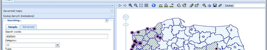
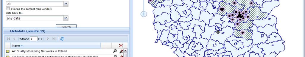
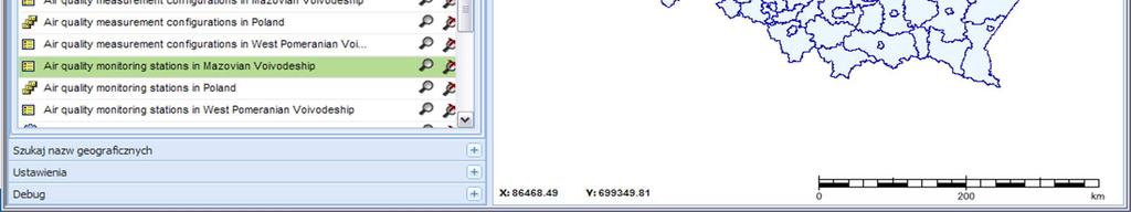
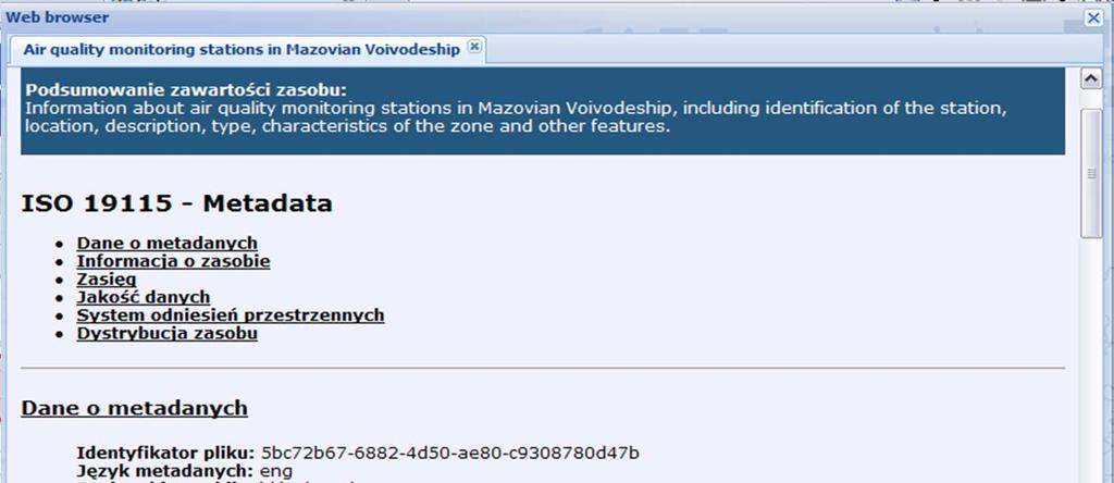
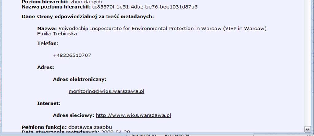
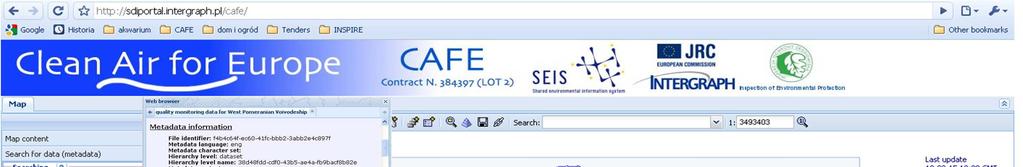
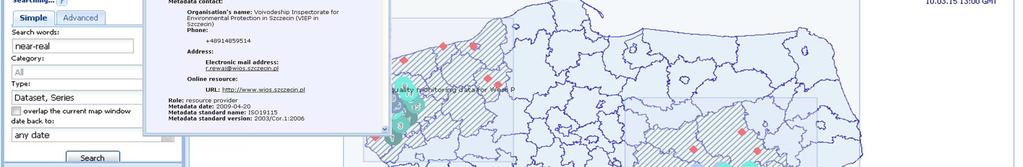
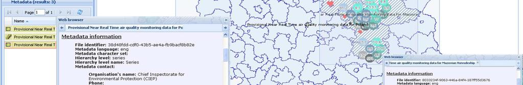
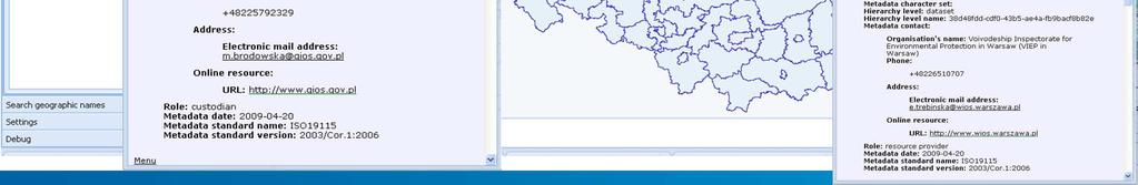
10 Metadata discovery example
11
 Requirements for scope of air quality information Technical requirements for air quality information exchange")

12 Data model specification for air quality data requirements CAFE requirements Draft CAFÉ Implementing Povisions (as of January 19, 2009) Requirements for scope of air quality information Technical requirements for air quality information exchange Requirements extracted from Airbase Data Dictionary INSPIRE requirements Recommended methodology for common model development Recommendations for INSPIRE data specifications Requirements of Generic Conceptual Model Requirements for Application schema encoding


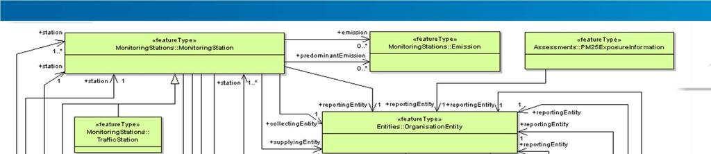
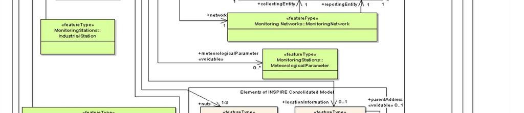
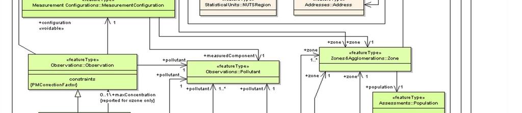
13 Model elements Feature types 18 Data Types 10 Code lists 38 16/3/2010 SEIS - CAFE Project final workshop - Brussels
14
15 Remodeling process - workflow DATA TRANSFER FILE FORMAT PHASE 1: PRELIMINARY PROCESSING OF PRODUCTION DATA STEP 1: Input data model analysis STEP 2: Output data model analysis DATABASE SCHEMA PRODUCTION DATABASE STEP 3: Model mapping STEP 4: Definition of data processing rules DATA TRANSFER FILE STEP 5: Execution of processing rules PUBLICATION DATABASE DOWNLOAD SERVICE PHASE 2 ON-THE-FLY TRANSFORMATION OF PUBLICATION DATA Apply XSLT SEIS - CAFE Project final Define workshop XSLT - transformation Brussels transformation DATABASE SCHEMA GML APPLICATION SCHEMA AIR QUALITY 15
16 Model Mapping - example ORIGINAL DATA MODEL SEIS-CAFE PILOT AIR QUALITY DATA MODEL FEATURE TYPE FEATURE ATTRIBUTE VALUE DOMAIN FEATURE TYPE FEATURE ATTRIBUTE VALUE DOMAIN Strefy nazwa strefy Datatype: Varchar2 Datatype: Zone zonename Minsize=1 CharacterString Maxsize=60 Strefy kod_strefy Datatype: Varchar2 Datatype: Zone zonecode Minsize=1 CharacterString Maxsize=60 Strefy zanieczyszczenia Datatype: Varchar2 Datatype: pollutant (foreign key to Zone Minsize=1 CharacterString Pollutant feature type) Maxsize=255 Strefy aglomeracja Datatype: Varchar2 Datatype: Zone zonetype Minsize=1 CharacterString Maxsize= 50 Strefy powierzchnia Datatype: Number Zone area Datatype: Number Strefy liczba_miesz Datatype: Varchar2 Datatype: population (foreign key to Zone Minsize=1 Number Population feature type) Maxsize= 255 Shp files Zone boundary source Datatype: (geospatial file/ LAU2 Zone geometry SDO_GEOMETRY list)
17 Original resources PROCESSED DATA Provisional near-real time data 336 instances of measurement data per day (CA:Observation instances) Validated monitoring data instancess of measurement data (CA: Observation instances) Assessment instances derived from original source (CA:AssessmentInformation instances)
18 Reporting workflow - now STATION LEVEL NETWORK LEVEL REGION LEVEL COUNTRY LEVEL MANUAL MEASUREMENTS AUTOMATIC STATIONS CS5 JPOAT-W JPOAT-K XR JPOAT-W R461 Questioannarie AUTOMATIC STATIONS MANUAL MEASUREMENTS
19 Reporting workflow oryginal source of information STATION LEVEL NETWORK LEVEL REGION LEVEL COUNTRY LEVEL MANUAL MEASUREMENTS AUTOMATIC STATIONS CS5 JPOAT-W JPOAT-K XR JPOAT-W R461 Questioannarie AUTOMATIC STATIONS MANUAL MEASUREMENTS
20 Reporting workflow INSPIRE services integration STATION LEVEL NETWORK LEVEL REGION LEVEL COUNTRY LEVEL AUTOMATIC STATIONS MANUAL MEASUREMENTS NRT_MAZ WFS Monitoring Facilities WFS CS5 JPOAT-W WFS JPOAT-K Validated Monitoring data XR JPOAT-W R461 Questioannarie AUTOMATIC STATIONS MANUAL MEASUREMENTS WFS NRT_MAZ NRT_MAZ WFS

21 Prototype architecture logical components Export validated monitoring data Production environment SEIS CAFE pilot publication environment Export assessment data Export monitoring facilities CIEP Production Environment WFS WMS INSPIRE download service Upload data Export NRT data txt files to ftp server VIEP Mazovia Production Environment INSPIRE view services CS-W INSPIRE Discovery services Get data Publish NRT data - website VIEP West- Pomeranian Production Environment
22 SEIS CAFE Pilot Geoportal WMS NRT BROKER WFS NRT BROKER CS-W WMS ZONES WMS MONITORING FACILITIES WFS MONITORING FACILITIES WFS VALIDATED DATA WFS ASSESSMENT On-the fly XSLT transformation WMS NRT MAZ WFS NRT MAZ Database VIEP MAZ WMS NRT WPOM Database VIEP WPOM WFS NRT WPOM Database Metadata catalogue Database CIEP FTP service File folder VIEP MAZ File folder VIEP WPOM FTP server File folder CIEP
23 Prototype Toward INSPIRE compliant services WFS Database schema (INSPIRE specific attributes included) support for voidable values, INSPIRE compliant domains (codelists and enumerations) PUBLICATION DATABASE CONFORMANCE TEST PASS FAIL Compliance to INSPIRE encoding rules --- x

 support for voidable values, INSPIRE")

24 Prototype Toward INSPIRE compliant services Adoption of database structures to GML encoding rules XSLT transformation WFS Database schema (INSPIRE specific attributes included) support for voidable values, INSPIRE compliant domains (codelists and enumerations) PUBLICATION DATABASE CONFORMANCE TEST PASS FAIL Compliance to INSPIRE encoding rules ---

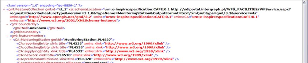
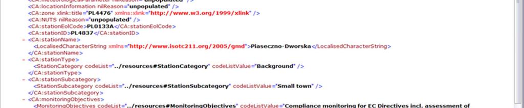
25 Prototype Toward INSPIRE compliant services GetFeature response before XSLT transformation: GetFeature response after XSLT transformation:
26 Reporting prototype - services As a part of the reporting prototype following types of Inspire web services was developed: Direct Access Download services WFS obligatory required by project specification View services (WMS) supplementary services published for SEIS-CAFE Pilot demonstration purposes Discovery service (CS W) supplementary service published for demonstration of metadata files developed under the project.
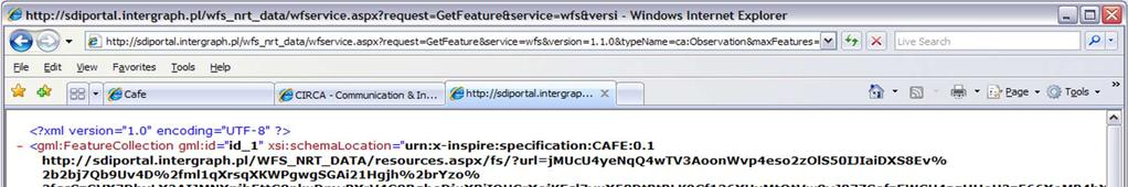
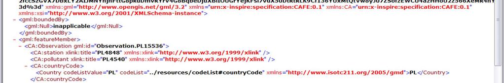
27 Reporting prototype services NRT Data NRT Data are published by services: WFS_MAZ Mazovian Voivodship region WFS_VPOM West-Pomeranian region WFS_NRT_Data aggregated services for both regions Feature types published: Observation Exceedance Example of Get Feature request: 0&typeName=ca:Observation&maxFeatures=2

28


29 16/3/2010 SEIS - CAFE Project final workshop - Brussels
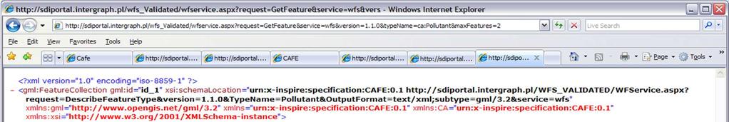
30 Reporting prototype Download service - validated monitoring data WFS_ValidatedAQD Feature types published: Observation Pollutant Example of Get Feature request: n=1.1.0&typename=ca:pollutant&maxfeatures=2
31
32 Reporting prototype Download service - monitoring facilities WFS_MonitoringFacilities Feature types published: MeasurementConfiguration MonitoringNetwork MonitoringStation Example of Get Feature request: =1.1.0&typeName=ca:MonitoringStation&maxFeatures=1
33
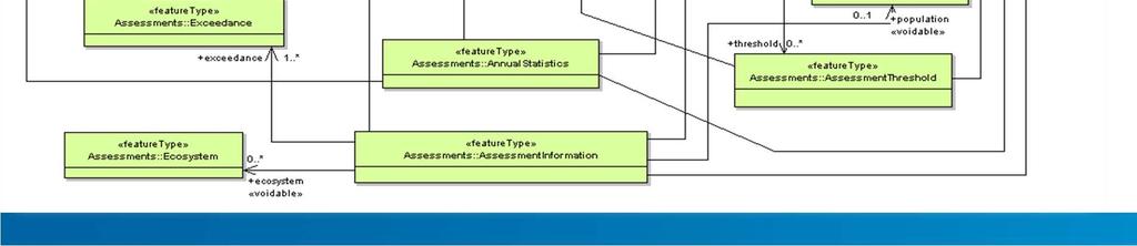
34 Reporting prototype Download service - Assessment WFS_Assessment Feature types published: MeasurementConfiguration MonitoringNetwork MonitoringStation Zone Pollutant Exceedance AssessmentInformation AnnualStatistics OrganisationEntity Example of Get Feature request: sion=1.1.0&typename=ca:assessmentinformation&maxfeatures=1
35
36 Compliance to the SEIS-CAFE Pilot requirements ADVANTAGES: 1. Provisional monitoring data: collected by the two independent regional LMOs: VIEP Mazovia and VIEP West-Pomeranian published throughout the two separate WFS services WFS_NRT_MAZ and WFS_NRT_WPOM, can be streamlined by cascading of services. into the single entry point (WFS_NRT DATA service) at national level. The responsibility for published data remains in hands of collecting entity. 2. The provisional monitoring data collected within a monitoring network on 1 hour basis can be provided to the public in a near-real time mode using WFS services. 3. WFS services allow fast access to the most recent air quality information. DISADVANTAGES: 1. The responses of WFS service are provided in GML format. Even it is a human readable format, it is not a user friendly way for delivery of AQ data to the public. 2. Reporting of air quality data using download services requires change of existing procedures for reporting of air quality. 3. The number of monitoring data is a significant factor decreasing efficiency of WFS services. 4. Defining of OGC filters for obtaining the AQ data necessary for reporting is not a simple activity and requires deep expertise on Filter Encoding standards. 4. WFS services support searching and download of interesting data by using filtering options. 5. Use of WFS services for delivery of air quality data simplifies the process of reporting and eliminates the effort related to data processing and preparation of written reports.


37 Toward user friendly viewing of air quality data


38 Sample R461 questionnaire site 16/3/2010 SEIS - CAFE Project final workshop - Brussels


39 Sample R461 questionnaire site

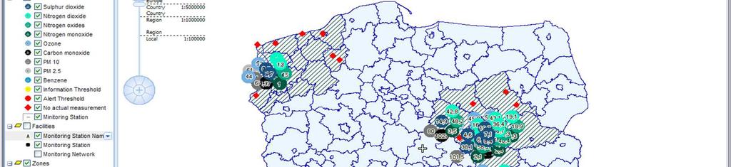
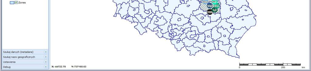
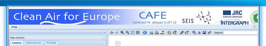
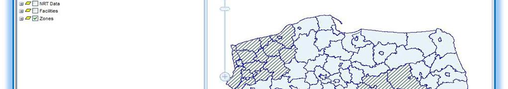
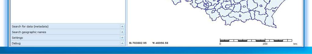
40 SEIS CAFE Geoportal presentation

41 26/06/2012 INSPIRE Conference - Istanbul 41

42 Thank you! Intergraph Corporation Alina Kmiecik IT Analyst Security, Government & Infrastructure Facilitator of INSPIRE TWG on Statistical Units & Population distribution-demography t: +48.(42) m: +48.(66) Intergraph Polska Sp. z. o.o. f: +48.(42) ul. Piotrkowska Łódź, Polska 42
Reporting and Exchange of Air Quality Information Under CAFE Directive Using INSPIRE Services Testbed Results
 Reporting and Exchange of Air Quality Information Under CAFE Directive Using INSPIRE Services Testbed Results Alina Kmiecik, Dominik Kobus, Magdalena Bednarek, Anna Zamolska, Piotr Krok, Marek Brylski,
Methodological approach for cross-theme harmonization of Polish spatial data sets the case study for the Annex I themes
 Methodological approach for cross-theme harmonization of Polish spatial data sets the case study for the Annex I themes Elżbieta Bielecka, Agnieszka Zwirowicz-Rutkowska, Alina Kmiecik, Marek Brylski, Magdalena
Initial Operating Capability & The INSPIRE Community Geoportal
 INSPIRE Conference, Rotterdam, 15 19 June 2009 1 Infrastructure for Spatial Information in the European Community Initial Operating Capability & The INSPIRE Community Geoportal EC INSPIRE GEOPORTAL TEAM
Introduction to INSPIRE. Network Services
 Introduction to INSPIRE. Network Services European Commission Joint Research Centre Institute for Environment and Sustainability Digital Earth and Reference Data Unit www.jrc.ec.europa.eu Serving society
Compass INSPIRE Services. Compass INSPIRE Services. White Paper Compass Informatics Limited Block 8, Blackrock Business
 Compass INSPIRE Services White Paper 2010 Compass INSPIRE Services Compass Informatics Limited Block 8, Blackrock Business Park, Carysfort Avenue, Blackrock, County Dublin, Ireland Contact Us: +353 1 2104580
GeoDCAT-AP Representing geographic metadata by using the "DCAT application profile for data portals in Europe"
 GeoDCAT-AP Representing geographic metadata by using the "DCAT application profile for data portals in Europe" Andrea Perego, Vlado Cetl, Anders Friis-Christensen, Michael Lutz, Lorena Hernandez Joint
The European Commission s science and knowledge service. Joint Research Centre
 The European Commission s science and knowledge service Joint Research Centre GeoDCAT-AP The story so far Andrea Perego, Antonio Rotundo, Lieven Raes GeoDCAT-AP Webinar 6 June 2018 What is GeoDCAT-AP Geospatial
INSPIRE overview and possible applications for IED and E-PRTR e- Reporting Alexander Kotsev
 INSPIRE overview and possible applications for IED and E-PRTR e- Reporting Alexander Kotsev www.jrc.ec.europa.eu Serving society Stimulating innovation Supporting legislation The European data puzzle 24
The cadastral data and standards based on XML in Poland
 The cadastral data and standards based on XML in Poland Jarosław Bydłosz, Piotr Parzych AGH University of Science and Technology Cracow, Poland 1 XML XML Extensible Markup Language Extensible Markup Language
How to Create a European INSPIRE Compliant Data Specification. Anja Hopfstock, BKG (Germany) Morten Borrebæk, SK (Norway)
 Morten Borrebæk, SK (Norway)") How to Create a European INSPIRE Compliant Data Specification Anja Hopfstock, BKG (Germany) Morten Borrebæk, SK (Norway) ESDIN Key Goals Further the ambition of the European Commission to create a European
How to Create a European INSPIRE Compliant Data Specification Anja Hopfstock, BKG (Germany) Morten Borrebæk, SK (Norway) ESDIN Key Goals Further the ambition of the European Commission to create a European
Integration of INSPIRE & SDMX data infrastructures for the 2021 population and housing census
 Integration of INSPIRE & SDMX data infrastructures for the 2021 population and housing census Nadezhda VLAHOVA, Fabian BACH, Ekkehard PETRI *, Vlado CETL, Hannes REUTER European Commission (*ekkehard.petri@ec.europa.eu
Christian Ansorge 27th April CDDA webinar 27th April Linked Approach as reporting mechanism
 Christian Ansorge 27th April 2017 CDDA webinar 27th April 2017 Linked Approach as reporting mechanism Generic Linked Approach Scope Background and motivation for reporting reusing INSPIRE Introduction
PortalU, a Tool to Support the Implementation of the Shared Environmental Information System (SEIS) in Germany
 in Germany") European conference of the Czech Presidency of the Council of the EU TOWARDS eenvironment Opportunities of SEIS and SISE: Integrating Environmental Knowledge in Europe http:/www.e-envi2009.org/proceedings/
European conference of the Czech Presidency of the Council of the EU TOWARDS eenvironment Opportunities of SEIS and SISE: Integrating Environmental Knowledge in Europe http:/www.e-envi2009.org/proceedings/
INSPIRE status report
 INSPIRE Team INSPIRE Status report 29/10/2010 Page 1 of 7 INSPIRE status report Table of contents 1 INTRODUCTION... 1 2 INSPIRE STATUS... 2 2.1 BACKGROUND AND RATIONAL... 2 2.2 STAKEHOLDER PARTICIPATION...
Metadata for Data Discovery: The NERC Data Catalogue Service. Steve Donegan
 Metadata for Data Discovery: The NERC Data Catalogue Service Steve Donegan Introduction NERC, Science and Data Centres NERC Discovery Metadata The Data Catalogue Service NERC Data Services Case study:
ISA Action 1.17: A Reusable INSPIRE Reference Platform (ARE3NA)
") ISA Action 1.17: A Reusable INSPIRE Reference Platform (ARE3NA) Expert contract supporting the Study on RDF and PIDs for INSPIRE Deliverable D.EC.3.2 RDF in INSPIRE Open issues, tools, and implications
ISA Action 1.17: A Reusable INSPIRE Reference Platform (ARE3NA) Expert contract supporting the Study on RDF and PIDs for INSPIRE Deliverable D.EC.3.2 RDF in INSPIRE Open issues, tools, and implications
INSPIRE & Environment Data in the EU
 INSPIRE & Environment Data in the EU Andrea Perego Research Data infrastructures for Environmental related Societal Challenges Workshop @ pre-rda P6 Workshops, Paris 22 September 2015 INSPIRE in a nutshell
Use case 1 INSPIRE harmonization of existing Energy Performance Certificate datasets Phase 1
 The European Commission s science and knowledge service Joint Research Centre Use case 1 INSPIRE harmonization of existing Energy Performance Certificate datasets Phase 1 Giacomo Martirano (external consultant)
INSPIRE: The ESRI Vision. Tina Hahn, GIS Consultant, ESRI(UK) Miguel Paredes, GIS Consultant, ESRI(UK)
 Miguel Paredes, GIS Consultant, ESRI(UK)") INSPIRE: The ESRI Vision Tina Hahn, GIS Consultant, ESRI(UK) Miguel Paredes, GIS Consultant, ESRI(UK) Overview Who are we? Introduction to ESRI Inc. and ESRI(UK) Presenters ArcGIS The ESRI Solution to
INSPIRE: The ESRI Vision Tina Hahn, GIS Consultant, ESRI(UK) Miguel Paredes, GIS Consultant, ESRI(UK) Overview Who are we? Introduction to ESRI Inc. and ESRI(UK) Presenters ArcGIS The ESRI Solution to
SEIS. (Shared Environmental Information System) From concept to information services
 From concept to information services") SEIS (Shared Environmental Information System) From concept to information services Stefan Jensen EEA supported by Sheila Cryan and Jon Maidens GSDI 11, Rotterdam 19.6.2009 What is SEIS is about... Sharing
SEIS (Shared Environmental Information System) From concept to information services Stefan Jensen EEA supported by Sheila Cryan and Jon Maidens GSDI 11, Rotterdam 19.6.2009 What is SEIS is about... Sharing
Web apps for INSPIRE: the ELISE Energy pilot example
 Web apps for INSPIRE: the ELISE Energy pilot example 6 September 2017 Authors: Daniele Francioli Giacomo Martirano Maria Teresa Borzacchiello Francesco Pignatelli Outline Overview of the ELISE Energy Pilot
Spatial Data on the Web
 Spatial Data on the Web Tools and guidance for data providers The European Commission s science and knowledge service W3C Data on the Web Best Practices 35 W3C/OGC Spatial Data on the Web Best Practices
(Towards) A metadata model for atmospheric data resources
 A metadata model for atmospheric data resources") (Towards) A metadata model for atmospheric data resources Anne De Rudder and Jean-Christopher Lambert Belgian Institute for Space Aeronomy (IASB-BIRA), Brussels The context EU FP7 Ground-based atmospheric
(Towards) A metadata model for atmospheric data resources Anne De Rudder and Jean-Christopher Lambert Belgian Institute for Space Aeronomy (IASB-BIRA), Brussels The context EU FP7 Ground-based atmospheric
European Location Framework (ELF) acting as a facilitator implementing INSPIRE
 acting as a facilitator implementing INSPIRE") www.eurogeographics.org European Location Framework (ELF) acting as a facilitator implementing INSPIRE Saulius Urbanas, Mick Cory (EuroGeographics) 29 October 2016 Copyright 2013 EuroGeographics EuroGeographics
www.eurogeographics.org European Location Framework (ELF) acting as a facilitator implementing INSPIRE Saulius Urbanas, Mick Cory (EuroGeographics) 29 October 2016 Copyright 2013 EuroGeographics EuroGeographics
Quality control service for Inspire data
 Quality control service for Inspire data INSPIRE Conference 2014 Aalborg Anders Foureaux Process Manager Data feeds Data hosting Environmental Informations Systems Unit Reasearch and Assessment Department
GENeric European Sustainable Information Space for Environment.
 GENeric European Sustainable Information Space for Environment http://www.genesis-fp7.eu/ Outline Introduction The GENESIS FP7 project The GENESIS solution s architecture GENESIS experience with INSPIRE
DanubeGIS User Manual Document number: Version: 1 Date: 11-Nov-2016
 DanubeGIS User Manual Document number: Version: 1 Date: 11-Nov-2016 Imprint Published by: ICPDR International Commission for the Protection of the Danube River ICPDR 2016 Contact ICPDR Secretariat Vienna
MY DEWETRA IPAFLOODS REPORT
 Grant Contract N. ECHO/SUB/2014/692292 Programme for Prevention, Preparedness and Response to Floods in the Western Balkans and Turkey IPA FLOODS Capacity Building Activities 2016 MY DEWETRA IPAFLOODS
SEXTANT 1. Purpose of the Application
 SEXTANT 1. Purpose of the Application Sextant has been used in the domains of Earth Observation and Environment by presenting its browsing and visualization capabilities using a number of link geospatial
Study and guidelines on Geospatial Linked Data as part of ISA Action 1.17 Resource Description Framework
 DG Joint Research Center Study and guidelines on Geospatial Linked Data as part of ISA Action 1.17 Resource Description Framework 6 th of May 2014 Danny Vandenbroucke Diederik Tirry Agenda 1 Introduction
Javier NOGUERAS-ISO 1, Manuel A. UREÑA-CÁMARA 2, Javier LACASTA 1, F. Javier ARIZA-LÓPEZ 2
 Checking the completeness and consistency of geographic metadata is not enough: evolution towards smart contracts for checking accuracy and correctness Javier NOGUERAS-ISO 1, Manuel A. UREÑA-CÁMARA 2,
Consolidation Team INSPIRE Annex I data specifications testing Call for Participation
 INSPIRE Infrastructure for Spatial Information in Europe Technical documents Consolidation Team INSPIRE Annex I data specifications testing Call for Participation Title INSPIRE Annex I data specifications
INSPIRE compliant e-reporting under the air quality directives from a member state perspective (Belgium)
") INSPIRE compliant e-reporting under the air quality directives from a member state perspective (Belgium) Olav Peeters Belgian Interregional Environment Agency (IRCEL CELINE) Content Who are we (IRCEL CELINE)
INSPIRE compliant e-reporting under the air quality directives from a member state perspective (Belgium) Olav Peeters Belgian Interregional Environment Agency (IRCEL CELINE) Content Who are we (IRCEL CELINE)
Draft meeting minutes
 Draft meeting minutes 6th meeting of the IPR Pilot Group Date & Time 8-10 October 2012, Copenhagen Location EEA, Copenhagen Attendees Representatives from the following IPR pilot countries: DE, DK, BE,
Standards, standardisation & INSPIRE Status, issues, opportunities
 Standards, standardisation & INSPIRE Status, issues, opportunities INSPIRE Coordination Team 6 th MIG meeting, 13-14 June 2017 Joint Research Centre The European Commission's science and knowledge service
SII Law Organization Coordination activities Examples of good practices Education Technical matters Success stories Challenges
 SII Law Organization Coordination activities Examples of good practices Education Technical matters Success stories Challenges INSPIRE transposed by the legal act on Spatial Information Infrastructure
INSPIRE & Linked Data: Bridging the Gap Part II: Tools for linked INSPIRE data
 Making the Web an Exploratory Place for Geospatial Knowledge INSPIRE & Linked Data: Bridging the Gap Part II: Tools for linked INSPIRE data Michalis Alexakis Spiros Athanasiou Nikos Georgomanolis Giorgos
Schema transformations in mass data harmonization process. Yohann Ly 8/9 Octobre 2013 Marne la Vallée
 Schema transformations in mass data harmonization process Yohann Ly 8/9 Octobre 2013 Marne la Vallée Mass data harmonization process Problematic : Multiple data providers Multiple storage format Multiple
Integrating the UK Location Information Infrastructure and data.gov.uk
 Integrating the UK Location Information Infrastructure and data.gov.uk Rod Kedge - UK Location Programme 1 July 20011 This presentation The issue: How to derive the benefits of INSPIRE Background UKLII
Leveraging metadata standards in ArcGIS to support Interoperability. David Danko and Aleta Vienneau
 Leveraging metadata standards in ArcGIS to support Interoperability David Danko and Aleta Vienneau Leveraging Metadata Standards in ArcGIS for Interoperability Why metadata and metadata standards? Overview
From the INSPIRE Engine Room
 From the INSPIRE Engine Room Michael Lutz ENiiG Conference, Lisbon 9 November 2016 Joint Research Centre the European Commission's in-house science service The JRC's role in INSPIRE Support MS in implementation
Addressing the needs of INSPIRE: The Challenges of improving Interoperability within the European Union
 Addressing the needs of INSPIRE: The Challenges of improving Interoperability within the European Union Andrew Coote Facilitator, Addresses Thematic Working Group andrew.coote@consultingwhere.com Disclaimer
Open Geospatial Consortium
 Open Geospatial Consortium Date: 28-March-2011 Reference number of this document: 10-195 Editors: OGC Aviation Domain Working Group Requirements for Aviation Metadata Copyright 2011 Open Geospatial Consortium.
IHO S-100 Framework. The Essence. WP / Task: Date: Author: hansc/dga Version: 0.6. Document name: IHO S-100 Framework-The Essence
 WP / Task: 4.4.1. Date: 2015-09-25 Author: hansc/dga Version: 0.6 Document name: IHO S-100 Framework-The Essence IHO S-100 Framework Version 0.6 The Essence Document information More recent versions of
Rui Reis, Maria José Vale, Marcelo Ribeiro, Bruno Meneses Geospatial World Forum 2016, May 2016, Rotterdam
 LC change detection and planning indicators Rui Reis, Maria José Vale, Marcelo Ribeiro, Bruno Meneses Summary 1. 2. 3. 4. 5. 6. 7. 8. Introduction Pilot overview Data description Inspire data harmonization
Reporting of modelled data under the AQD IPR for e-reporting
 Reporting of modelled data under the AQD IPR for e-reporting RETROSPECTIVE OF PILOT TESTING IN 2012 & MODELLING DATA Tony Bush 6 th pilot meeting Copenhagen 8-10 October 2012 Introduction Where does modelled
METAINFORMATION INFRASTRUCTURE FOR GEOSPATIAL INFORMATION
 2010/2 PAGES 1 7 RECEIVED 15. 6. 2009 ACCEPTED 2. 3. 2010 T. KLIMENT METAINFORMATION INFRASTRUCTURE FOR GEOSPATIAL INFORMATION ABSTRACT Tomáš KLIMENT email: tomas.kliment@stuba.sk Research field: Spatial
AQD IPR pilot study programme on e-reporting
 AQD IPR pilot study programme on e-reporting Progress on UTD Jaume Targa 6 th pilot meeting Copenhagen 8-10 October May 2012 Introduction Important points on UTD Re-delivering UTD data Aggregation rules
Guidelines for the encoding of spatial data
 INSPIRE Infrastructure for Spatial Information in Europe Guidelines for the encoding of spatial data Title Status Creator Date 2012-06-15 Subject Publisher Type Description Contributor Format Source Rights
Reducing Consumer Uncertainty
 Spatial Analytics Reducing Consumer Uncertainty Towards an Ontology for Geospatial User-centric Metadata Introduction Cooperative Research Centre for Spatial Information (CRCSI) in Australia Communicate
Toward Horizon 2020: INSPIRE, PSI and other EU policies on data sharing and standardization
 Toward Horizon 2020: INSPIRE, PSI and other EU policies on data sharing and standardization www.jrc.ec.europa.eu Serving society Stimulating innovation Supporting legislation The Mission of the Joint Research
ELF download services
 ELF download services Presentation to: Author: Date: ELF workshop in Moldova Marcin Grudzień 8 h September2015 14 September, 2015 Plan Introduction Specification documents The envisaged production process
Automatic Creation of INSPIRE Meta-information from SWE Services
 S@NY Automatic Creation of INSPIRE Meta-information from SWE Services Désirée Hilbring, Fraunhofer IITB hilbring@iitb.fraunhofer.de Agile 2009 Challenges in Geospatial Data Harmonization, Hanover Copyright
The UK Marine Environmental Data and Information Network MEDIN
 The UK Marine Environmental Data and Information Network MEDIN M. Charlesworth, R. Lowry, H. Freeman, J. Rapaport, B Seeley Content MEDIN - a brief overview for context Discovery Metadata Standard and
ARCHITECTURE OF SPATIAL DATA INFRASTRUCTURE (SDI) (DRAFT)
 (DRAFT)") ARCHITECTURE OF SPATIAL DATA INFRASTRUCTURE (SDI) (DRAFT) Author: Carlo Cipolloni September 20, 2018 Version 1.0 A SDI platform to support the SEIS in the ENP South region Introduction Based on the Contribution
ARCHITECTURE OF SPATIAL DATA INFRASTRUCTURE (SDI) (DRAFT) Author: Carlo Cipolloni September 20, 2018 Version 1.0 A SDI platform to support the SEIS in the ENP South region Introduction Based on the Contribution
Air Quality & e-reporting from the perspective of Belgium
 Air Quality & e-reporting from the perspective of Belgium Olav Peeters Belgian Interregional Environment Agency (IRCEL CELINE) Content Who are we (IRCEL CELINE) and what do we do? E-reporting from our
The coastal data in the regional and national territorial data repertory. Genova 24 Aprile 2012 Anna Cerrato Regione Liguria
 The coastal data in the regional and national territorial data repertory Genova 24 Aprile 2012 Anna Cerrato Regione Liguria www.rndt.gov.it Experience from data providers in using transformation tools
Reducing Consumer Uncertainty Towards a Vocabulary for User-centric Geospatial Metadata
 Meeting Host Supporting Partner Meeting Sponsors Reducing Consumer Uncertainty Towards a Vocabulary for User-centric Geospatial Metadata 105th OGC Technical Committee Palmerston North, New Zealand Dr.
Development of guidelines for publishing statistical data as linked open data
 Development of guidelines for publishing statistical data as linked open data MERGING STATISTICS A ND GEOSPATIAL INFORMATION IN M E M B E R S TATE S POLAND Mirosław Migacz INSPIRE Conference 2016 Barcelona,
Esri Support for Geospatial Standards
 APRIL 2017 ArcGIS Is Open and Interoperable Esri Support for Geospatial Standards Copyright 2017 Esri All rights reserved. Printed in the United States of America. The information contained in this document
Draft INSPIRE Implementing Rule on Metadata
 Document: D/GIS/97/EN Original Meeting of the Working Party "Geographical Information Systems for Statistics" Joint meeting with National Statistical Offices and National Mapping Agencies Luxembourg, March
Testing - an essential aspect of establishing an SDI
 Testing - an essential aspect of establishing an SDI Clemens Portele, Anders Östman, Michael Koutroumpas, Xin He, Janne Kovanen, Markus Schneider, Andriani Skopeliti INSPIRE Conference 2011 30 June 2011
This document is a preview generated by EVS
 TECHNICAL SPECIFICATION SPÉCIFICATION TECHNIQUE TECHNISCHE SPEZIFIKATION CEN ISO/TS 19139 November 2009 ICS 35.240.70 English Version Geographic information - Metadata - XML schema implementation (ISO/TS
FP7-INFRASTRUCTURES Grant Agreement no Scoping Study for a pan-european Geological Data Infrastructure D 4.4
 FP7-INFRASTRUCTURES-2012-1 Grant Agreement no. 312845 Scoping Study for a pan-european Geological Data Infrastructure D 4.4 Report on recommendations for implementation of the EGDI Deliverable number D4.4
Validation in the Netherlands and European Location Framework
 Validation in the Netherlands and European Location Framework INSPIRE Workshop on validation and conformity testing 15 16 May 2014 Thijs Brentjens Contents Geonovum and ELF INSPIRE INSPIRE in the Netherlands
INSPIRE tools What's new?
 INSPIRE tools What's new? Michael Lutz INSPIRE Conference, Antwerp 18 September 2018 Joint Research Centre The European Commission s science and knowledge service INSPIRE reference validator Why a reference
Validation experience
 Validation experience Paloma Abad Head of SDI Department SDI Workshop 26-06-2018 INSPIRE KEN INSPIRE KEN, june 2018 1 Points 1. Introduction 2. Interoperability 3. Geoportal Thematic Viewer 4. Conclusions
EarthLookCZ as Czech way to GMES
 EarthLookCZ as Czech way to GMES Karel Charvat 1 and Petr Horak 1 1 WirelessInfo, Czech Republic, charvat@wirelessinfo.cz Abstract Global Monitoring for Environment and Security is one of 4 ranges of solutions
Suggestions for writing Abstract Test Suites (ATS) for INSPIRE conformance testing for Metadata and Network Services
 for INSPIRE conformance testing for Metadata and Network Services") Suggestions for writing Abstract Test Suites (ATS) for INSPIRE conformance testing for Metadata and Network Services MIWP-5 Workshop 02. December 2014 Sven Böhme, Federal Agency for Cartography and Geodesy
Suggestions for writing Abstract Test Suites (ATS) for INSPIRE conformance testing for Metadata and Network Services MIWP-5 Workshop 02. December 2014 Sven Böhme, Federal Agency for Cartography and Geodesy
Guidelines for the encoding of spatial data
 INSPIRE Infrastructure for Spatial Information in Europe Guidelines for the encoding of spatial data Title D2.7: Guidelines for the encoding of spatial data, Version 3.1 Creator INSPIRE Drafting Team "Data
INSPIRE Coverage Types
 INSPIRE Infrastructure for Spatial Information in Europe INSPIRE Coverage Types Title Status Creator Date 2012-06-15 Subject Publisher Type Description Contributor Format Source Rights Identifier Language
Metadata of geographic information
 Metadata of geographic information Kai Koistinen Management of environmental data and information 4.10.2017 Topics Metadata of geographic information What is metadata? Metadata standards and recommendations
Note: For the creation of an application schema several software tools can be used. Enterprise Architect is one of the tools that can be used.
 1.0 Definitions 1.1 Application Schema - An application schema is a fundamental element of any S-100 based product specification. The application schema serves two purposes: - It achieves a common and
MetOcean Themes in INSPIRE
 MetOcean Themes in INSPIRE Cliquez pour modifier le style du titre 4th Workshop on the use of GIS/OGC standards in meteorology Cliquez pour modifier le style des sous-titres Frédéric du Guillaud masque
AQD IPR pilot study programme on e-reporting
 AQD IPR pilot study programme on e-reporting A quick start guide working with the e-reporting schemata Tony Bush 4 th pilot meeting Copenhagen 15-16 March 2012 Introduction What to worry about first if
ELF extensions. Presentation to: INSPIRE MIG-T. Author: Anja Hopfstock (ELF WP2 Data Specifications) Date: 25 th February 2016.
 Date: 25 th February 2016.") ELF extensions Presentation to: Author: Date: INSPIRE MIG-T Anja Hopfstock (ELF WP2 Data Specifications) 25 th February 2016 What is ELF in connection to INSPIRE? Arrangements within NMCAs in Europe to
ELF extensions Presentation to: Author: Date: INSPIRE MIG-T Anja Hopfstock (ELF WP2 Data Specifications) 25 th February 2016 What is ELF in connection to INSPIRE? Arrangements within NMCAs in Europe to
Delivery guide for Environmental Noise Data:
 Delivery guide for Environmental Noise Data: DF0: Definition of reporting structure Type of Document: Draft guidelines Annex DF0 Prepared by: Colin Nugent, Núria Blanes, Jaume Fons, Miquel Sáinz de la
Commission Action Plan on Compliance and Governance
 Expert Group "Greening the European Semester / Environmental Implementation Review" 23 January 2018, Brussels Commission Action Plan on Compliance and Governance KEY FINDINGS OF PREPARATORY STAGE EIR
The federal geo-platform:
 The federal geo-platform: Targeting the statistical community Nathalie Delattre (IGN Belgium), Pierre Jamagne (Statistics Belgium), Ann Crabbé (KULeuven/SADL) INSPIRE Conference, Strasbourg 6-8 septembre
Download Service Implementing Rule and Technical Guidance
 Download and Transformation Draft Implementing Rules Presentation for INSPIRE Initiatives Download Service Implementing Rule and Technical Guidance Olaf Østensen Statens kartverk Norwegian Mapping Authority
Understanding and Using Metadata in ArcGIS. Adam Martin Marten Hogeweg Aleta Vienneau
 Understanding and Using Metadata in ArcGIS Adam Martin Marten Hogeweg Aleta Vienneau Adam Martin National Government Account Management R&D Open Data Marten Hogeweg National Government Professional Services
INSPIRE Geoportal Rich user experience across member states services
 INSPIRE Geoportal Rich user experience across member states services developed under a contract with the EC (JRC) Diomede ILLUZZI 1 Nicola LUNANOVA 1 Torsten FRIEBE 2 1 Planetek Italia s.r.l Via Masaua
The EOC Geoservice: Standardized Access to Earth Observation Data Sets and Value Added Products ABSTRACT
 The EOC Geoservice: Standardized Access to Earth Observation Data Sets and Value Added Products K. Dengler, T. Heinen, A. Huber, K. Molch, E. Mikusch German Aerospace Center (DLR) German Remote Sensing
Overview. Overview. Broadsheet for PNAMP Metadata Builder. Metadata Entity Set Information. Taurus Monitoring
 Overview Overview The Metadata Builder Tool aims to facilitate and encourage the development of metadata for aquatic monitoring data collected by government agencies and partners in the Pacific Northwest.
HUMBOLDT Application Scenario: Protected Areas
 CC by Erlend Schei Copyright by Kecko Copyright by Michael Bezzina CC by Gunnar Ries Copyright by Michael Bezzina Copyright by Michael Bezzina Copyright by Michael Bezzina CC by fs999 CC by Jordan Nielsen
1. CONCEPTUAL MODEL 1.1 DOMAIN MODEL 1.2 UML DIAGRAM
 1 1. CONCEPTUAL MODEL 1.1 DOMAIN MODEL In the context of federation of repositories of Semantic Interoperability s, a number of entities are relevant. The primary entities to be described by ADMS are the
TAP RETAIL CHANGE REQUESTS
 TAP RETAIL CHANGE REQUESTS Project: TAP Phase One Release: 1.0 To DG MOVE, ERA, TAP Steering Committee Date: 13 May 2012 Author: Owner: Client: Document Ref: Ugo Dell Arciprete (Work Stream Leader) TAP
Implementation of a reporting workflow to maintain data lineage for major water resource modelling projects
 18 th World IMACS / MODSIM Congress, Cairns, Australia 13-17 July 2009 http://mssanz.org.au/modsim09 Implementation of a reporting workflow to maintain data lineage for major water Merrin, L.E. 1 and S.M.
SAFER the GIGAS Effect
 SAFER the GIGAS Effect How INSPIRE, GMES and GEOSS are influencing EC projects Arnaud Cauchy 23/06/2010 Agenda GIGAS Project Summary SAFER Project Summary SAFER Original Approach GIGAS Influences SAFER
International Organization for Standardization Technical Committee 211 (ISO/TC211)
") Esri Support for Geospatial Standards: Open Geospatial Consortium (OGC) International Organization for Standardization Technical Committee 211 (ISO/TC211) An Esri White Paper April 2015 Copyright 2015
Esri Support for Geospatial Standards: Open Geospatial Consortium (OGC) International Organization for Standardization Technical Committee 211 (ISO/TC211) An Esri White Paper April 2015 Copyright 2015
Air Quality e-reporting: Data handling
 Air Quality e-reporting: Data handling EEA & ETC/ACM efforts compiled by Artur sella 12 th IPR Pilot Meeting Copenhagen, 12 th of November 2014 What happens with data after delivery?! Validation, QA (Tier1)
DATA VALIDATION AGAINST SCHEMA AND SOURCE DATA
 DATA VALIDATION AGAINST SCHEMA AND SOURCE DATA didier.bouteloup@ign.fr; dominique.laurent@ign.fr 3 June 2016 ign.fr Context IGN has performed data validation twice On test INSPIRE data (2013-2014) On ELF
The New Electronic Chart Product Specification S-101: An Overview
 The New Electronic Chart Product Specification S-101: An Overview Julia Powell Marine Chart Division, Office of Coast Survey, NOAA 1315 East West Hwy, Silver Spring, MD 20715 Julia.Powell@noaa.gov 301-713-0388
Detailed analysis + Integration plan
 Outline Integration methodology Detailed analysis + Integration plan Conclusions 2 Outline Integration methodology Detailed analysis + Integration plan Conclusions 3 EULF-ISA Integration: methodology Phase
S-100 Product Specification Roll Out Implementation Plan. Introduction
 S-100 Product Specification Roll Out Implementation Plan Introduction This intent of this plan is to provide status, challenges, timelines, and strategies for the suite of S-100 products under development
Basic Principles of MedWIS - WISE interoperability
 Co-ordination committee seminar of the national focal points Basic Principles of MedWIS - WISE interoperability Eduardo García ADASA Sistemas Nice - France Agenda WISE vs MedWIS WISE WISE DS WISE vs WISE
Glossary of Exchange Network Related Groups
 Glossary of Exchange Network Related Groups CDX Central Data Exchange EPA's Central Data Exchange (CDX) is the point of entry on the National Environmental Information Exchange Network (Exchange Network)
Extending SOA Infrastructure for Semantic Interoperability
 Extending SOA Infrastructure for Semantic Interoperability Wen Zhu wzhu@alionscience.com ITEA System of Systems Conference 26 Jan 2006 www.alionscience.com/semantic Agenda Background Semantic Mediation
Long-term preservation for INSPIRE: a metadata framework and geo-portal implementation
 Long-term preservation for INSPIRE: a metadata framework and geo-portal implementation INSPIRE 2010, KRAKOW Dr. Arif Shaon, Dr. Andrew Woolf (e-science, Science and Technology Facilities Council, UK) 3
DATA SHARING AND DISCOVERY WITH ARCGIS SERVER GEOPORTAL EXTENSION. Clive Reece, Ph.D. ESRI Geoportal/SDI Solutions Team
 DATA SHARING AND DISCOVERY WITH ARCGIS SERVER GEOPORTAL EXTENSION Clive Reece, Ph.D. ESRI Geoportal/SDI Solutions Team Geoportal Extension for ArcGIS Server Context within an Enterprise Spatial Data Infrastructure