Optical Theory Basics - 2 Atmospheric corrections and parameter retrieval
|
|
|
- Herbert Simmons
- 5 years ago
- Views:
Transcription

1 Optical Theory Basics - 2 Atmospheric corrections and parameter retrieval Jose Moreno 3 September 2007, Lecture D1Lb2
2 OPTICAL THEORY-FUNDAMENTALS (2) Radiation laws: definitions and nomenclature Sources of radiation in natural environment in the optical domain Interaction of radiation with matter in the optical domain Illumination and observation geometries Radiative transfer in the optical domain General solutions for the radiation transfer in the coupled earth-surface and through the atmosphere Derivation of surface reflectance from measured satellite radiances Spectral information: signatures of natural objects Spatial information: uniformity, textures and scales Temporal information: land surface dynamics at multiple scales Information retrieval: from spectral indices to model inversion Overview of applications 3 September 2007 D1Lb2 Atmospheric corrections and parameter retrievals Jose Moreno 2
3 Derivation of surface reflectance from measured satellite radiance 3 September 2007 D1Lb2 Atmospheric corrections and parameter retrievals Jose Moreno 3
4 Pre-processing steps: - Radiometric calibration - Noise removal - Cloud screening - Geometric correction - Atmospheric correction - Database management 3 September 2007 D1Lb2 Atmospheric corrections and parameter retrievals Jose Moreno 4
5 RADIOMETRIC CALIBRATION Pre-launch radiometric calibration to traceable standard (accepted reference) Post launch calibration campaigns to maintain/monitoring in flight calibration (vicarious) On-board calibration (both radiometric and spectral) 3 September 2007 D1Lb2 Atmospheric corrections and parameter retrievals Jose Moreno 5


6 CLOUD SCREENING - Very dependent on the available spectral information - Many different algorithms (from simple thresholds up to sophisticate techniques) 3 September 2007 D1Lb2 Atmospheric corrections and parameter retrievals Jose Moreno 6

7 3 September 2007 D1Lb2 Atmospheric corrections and parameter retrievals Jose Moreno 7
8 SATELLITE SIGNAL MODELLING 3 September 2007 D1Lb2 Atmospheric corrections and parameter retrievals Jose Moreno 8
9 The atmosphere modifies the radiation measured by optical sensors: Aerosols and gases present optical activity at VIS/NIR/SWIR. Reflectance increases/decreases depending on the wavelength. Image loses contrast. Removing the atmospheric influence from remote sensing data is necessary before the data exploitation 3 September 2007 D1Lb2 Atmospheric corrections and parameter retrievals Jose Moreno 9
10 Surface reflectance retrieval TOA radiance modeled assuming Lambertian reflectance for the target: Analytically invertible to retrieve ρ s. Removal of adjacency effects 3 September 2007 D1Lb2 Atmospheric corrections and parameter retrievals Jose Moreno 10
11 Flat Lambertian areas: INVERSION OF SURFACE REFLECTANCE Non-Lambertian areas with topographic structure: - no analytic inversion under approximations - decoupling 'effective' reflectances and 'effective geometric terms required for environment - multistep numerical procedure required for inversion - multiple reflection terms only significant for high reflectance surroundings 3 September 2007 D1Lb2 Atmospheric corrections and parameter retrievals Jose Moreno 11
12 Atmospheric composition Permanent Constituents Variable constituents Constituent % by volume Constituent % by volume Nitrogen (N 2 ) Water Vapor (H 2 O) 0.04 Oxygen (O 2 ) Ozone (O 3 ) 12 x 10-4 Argon (Ar) Sulfur dioxide (SO 2 ) b x 10-4 Carbon dioxide (CO 2 ) Nitrogen dioxide (NO 2 ) x 10-4 Neon (Ne) x 10-4 Ammonia (NH 3 ) x 10-4 Helium (He) 5.24 x 10⁻⁴ Nitric oxide (NO) x 10-4 Krypton (Kr) 1.14 x 10⁻⁴ Hydrogen sulfide (H 2 S) x 10-4 Xenon (Xe) x 10-4 Nitric acid vapor trace Hydrogen (H 2 ) 0.5 x 10⁻⁴ Methane (CH 4 ) 1.5 x 10⁻⁴ Nitrous Oxide (N 2 O) 0.27 x 10⁻⁴ Carbon Monoxide (CO) 0.19 x September 2007 D1Lb2 Atmospheric corrections and parameter retrievals Jose Moreno 12
13 3 September 2007 D1Lb2 Atmospheric corrections and parameter retrievals Jose Moreno 13

14 3 September 2007 D1Lb2 Atmospheric corrections and parameter retrievals Jose Moreno 14

15 3 September 2007 D1Lb2 Atmospheric corrections and parameter retrievals Jose Moreno 15
16 3 September 2007 D1Lb2 Atmospheric corrections and parameter retrievals Jose Moreno 16

17 3 September 2007 D1Lb2 Atmospheric corrections and parameter retrievals Jose Moreno 17
18 ATMOSPHERIC INFORMATION Height (gpm) In-situ radiosoundings Temperature Height (gpm) Relative Humidity (%) solar radiation (W m nm ) In-situ spectral irradiance dir ect global 0-80,0-60,0-40,0-20,0 0,0 20,0 40,0 Temperature (¼C) RH (%) Ozone wavelength (nm) Height (gpm) Total Optical Depth ,00 2,00 4,00 6,00 8,00 10,00 12,00 14,00 16, Ozone (mpa) wavelength (nm) 3 September 2007 D1Lb2 Atmospheric corrections and parameter retrievals Jose Moreno 18
19 3 September 2007 D1Lb2 Atmospheric corrections and parameter retrievals Jose Moreno 19

20 Surface reflectance retrieval Atmospheric correction: Removal of the atmospheric effects from the measured at-sensor radiance, leading to the derivation of surface reflectance images. Aerosols Water vapor 3 September 2007 D1Lb2 Atmospheric corrections and parameter retrievals Jose Moreno 20

21 TOA BOA 3 September 2007 D1Lb2 Atmospheric corrections and parameter retrievals Jose Moreno 21


22 Topographic effects Cosine correction Hay s model µ s DEM µ il + = 3 September 2007 D1Lb2 Atmospheric corrections and parameter retrievals Jose Moreno 22

23 3 September 2007 D1Lb2 Atmospheric corrections and parameter retrievals Jose Moreno 23
24 BRDF effects 3 September 2007 D1Lb2 Atmospheric corrections and parameter retrievals Jose Moreno 24
25 Spectral information: signatures of natural objects 3 September 2007 D1Lb2 Atmospheric corrections and parameter retrievals Jose Moreno 25


 2500-90")
26 view zenith angle wavelength (nm) 0.00 Hyperspectral BRDF Solar Principal Plane C = cm water 400 wavelength (nm) view zenith angle 3 September 2007 D1Lb2 Atmospheric corrections and parameter retrievals Jose Moreno 26

27 3 September 2007 D1Lb2 Atmospheric corrections and parameter retrievals Jose Moreno 27
28 SOIL REFLECTANCE 3 September 2007 D1Lb2 Atmospheric corrections and parameter retrievals Jose Moreno 28
29 green vegetation (alfalfa) senescent vegetation (barley) reflectance wavelength ( μm) 3 September 2007 D1Lb2 Atmospheric corrections and parameter retrievals Jose Moreno 29
30 reflectance bare soil organic litter (humic acid) wavelength (nm) 3 September 2007 D1Lb2 Atmospheric corrections and parameter retrievals Jose Moreno 30
31 3 September 2007 D1Lb2 Atmospheric corrections and parameter retrievals Jose Moreno 31
32 3 September 2007 D1Lb2 Atmospheric corrections and parameter retrievals Jose Moreno 32


33 CHRIS HyMap MERIS Landsat TM 3 September 2007 D1Lb2 Atmospheric corrections and parameter retrievals Jose Moreno 33
34 3 September 2007 D1Lb2 Atmospheric corrections and parameter retrievals Jose Moreno 34
35 Spatial information: uniformity, textures and scales 3 September 2007 D1Lb2 Atmospheric corrections and parameter retrievals Jose Moreno 35


36 <1-300 meters SPATIAL SCALES TO BE RESOLVED 10 km to global Local site Global sampling 3 September 2007 D1Lb2 Atmospheric corrections and parameter retrievals Jose Moreno 36


37 Multiresolution data VIS/NIR/SWIR Colour Composite Thermal data 1.25 m 3.75 m 12.0 m 3 September 2007 D1Lb2 Atmospheric corrections and parameter retrievals Jose Moreno 37


38 Spatial information in the images -Textures -Higherorder statistics 3 September 2007 D1Lb2 Atmospheric corrections and parameter retrievals Jose Moreno 38

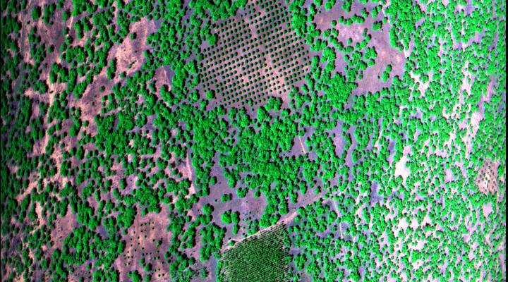
39 counting individual trees by using Quickbird very high resolution imagery 3 September 2007 D1Lb2 Atmospheric corrections and parameter retrievals Jose Moreno 39

40 0,7 0,6 0,5 0,4 PA N BLUE GREEN RED 0,3 NIR 0,2 0,1 QuickBird 0,0 0,300 0,325 0,350 0,375 0,400 0,425 0,450 0,475 0,500 0,525 0,550 0,575 0,600 0,625 0,650 0,675 0,700 0,725 0,750 0,775 0,800 0,825 0,850 0,875 0,900 0,925 0,950 0,975 1,000 1,025 1,050 1,075 1,100 3 September 2007 D1Lb2 Atmospheric corrections and parameter retrievals Jose Moreno 40
41 Temporal information: land surface dynamics at multiple scales 3 September 2007 D1Lb2 Atmospheric corrections and parameter retrievals Jose Moreno 41
42 3-10 days TIME SCALES TO BE RESOLVED > 3 years Requires very large time series 3 September 2007 D1Lb2 Atmospheric corrections and parameter retrievals Jose Moreno 42

43 Time series: Coupling canopy functioning and radiative transfer models for remote sensing data assimilation 3 September 2007 D1Lb2 Atmospheric corrections and parameter retrievals Jose Moreno 43


44 MERIS - 14 July 2003 Landsat - 15 July 2003 MERIS and Landsat both provide time series at different spatial and temporal scales 3 September 2007 D1Lb2 Atmospheric corrections and parameter retrievals Jose Moreno 44
45 Stable calibration, adequate cloud screening and precise atmospheric corrections are needed for time series analisis 3 September 2007 D1Lb2 Atmospheric corrections and parameter retrievals Jose Moreno 45
46 Information retrieval: from spectral indices to model inversion 3 September 2007 D1Lb2 Atmospheric corrections and parameter retrievals Jose Moreno 46
47 3 September 2007 D1Lb2 Atmospheric corrections and parameter retrievals Jose Moreno 47


48 3 September 2007 D1Lb2 Atmospheric corrections and parameter retrievals Jose Moreno 48
49 MERIS Terrestrial Chlorophyll Index (MTCI) 3 September 2007 D1Lb2 Atmospheric corrections and parameter retrievals Jose Moreno 49


50 Retrievals from hyperspectral data: Leaf chlorophyll Leaf chlorophyll y = 0,0359x + 0,347 R 2 = 0,3789 Corn bar1_12 Sugarbeet bar1_1 Barley bar1_12 Wheat bar1_12 Alfalfa bar1_12 Corn bar2_12 Sugarbeet bar2_1 Barley bar2_12 Wheat bar2_12 Alfalfa bar2_12 Sugarbeet bar1_9 Alfalfa bar1_9 Sugarbeet bar2_9 Alfalfa bar2_9 Sugarbeet bar1_1 Alfalfa bar1_15 Sugarbeet bar2_1 Alfalfa bar2_ Index Canopy water y = 3,1431x + 857, R 2 = 0, Corn bar1_12 Subarbeet_bar1_12 Barley bar1_12 Wheat_bar1_12 Alfalfa bar_1_12 Corn bar2_12 Sugarbeet bar2_12 Barley bar2_12 wheat bar2_12 Alfalfa bar2_12 Sugarbeet bar1_9 Alfalfa bar1_9 Sugarbeet bar2_9 Alfalfa bar2_9 Sugarbeet bar1_15 Alfalfa bar1_15 Subarbeet bar2_15 Alfalfa bar2_ Index 3 September 2007 D1Lb2 Atmospheric corrections and parameter retrievals Jose Moreno 50
51 Verhoef and Bach, September 2007 D1Lb2 Atmospheric corrections and parameter retrievals Jose Moreno 51


52 turbid medium separation green / senescent parts: LAI T = LAI G + LAI S 3 September 2007 D1Lb2 Atmospheric corrections and parameter retrievals Jose Moreno 52
53 Choice of the merit function Incorporation of the uncertainties in the inverse process: The maximum likelihood on the variables minimize: χ 2 t = CRM CRM ) [ ] [ ] [ ] t R [ ] mes R ( V) W 1 Rmes R ( V + V V p C 1 V V p Residuals Residuals if diagonal matrixes a priori Covariance Matrix Radiometric Part M i R i mes Ri σ i CRM R ( V) 2 a priori Covariance Matrix Variable Part N j σ i V i i Vp V 2 3 September 2007 D1Lb2 Atmospheric corrections and parameter retrievals Jose Moreno 53

54 Neural network methods 3 September 2007 D1Lb2 Atmospheric corrections and parameter retrievals Jose Moreno 54

55 Spectral-angular synergy: ALFALFA V16 - C01 UTM-X: UTM-Y: LAI = 1.84 fcover = 0.95 Li ne 1, n o o n Li ne 2, n o o n Li ne 1, morning Li ne 2, morning Li ne 1, afternoon Li ne 2, afternoon Homogeneous vegetation: Spectral information dominant reflectance reflectance SUGAR BEET wavelength (nm) SV6 - C03 UTM-X: UTM-Y: LA I = 1.71 fcover = 0.61 Li ne 1, n o o n Li ne 2, n o o n Li ne 1, morning Li ne 2, morning Li ne 1, afternoon Li ne 2, afternoon Heterogeneous vegetation: Angular information dominant wa veleng th (nm) application of synergy 3 September 2007 D1Lb2 Atmospheric corrections and parameter retrievals Jose Moreno 55
56 Overview of applications 3 September 2007 D1Lb2 Atmospheric corrections and parameter retrievals Jose Moreno 56
57 REMOTE SENSING OF LAND SURFACE PROCESSES - Mapping Applications - cartography - thematic mapping - Monitoring Applications - ecosystems dynamics - natural hazards (fires, floods, desertification) - Research about Land Surface Processes - heat and mass exchange at Land/Atmosphere interface - photosynthesis and net primary production - hydrologic processes - Land/Atmosphere exchange of biochemicals 3 September 2007 D1Lb2 Atmospheric corrections and parameter retrievals Jose Moreno 57

58 3 September 2007 D1Lb2 Atmospheric corrections and parameter retrievals Jose Moreno 58

59 3 September 2007 D1Lb2 Atmospheric corrections and parameter retrievals Jose Moreno 59

60 3 September 2007 D1Lb2 Atmospheric corrections and parameter retrievals Jose Moreno 60


61 carbon cycle water cycle 3 September 2007 D1Lb2 Atmospheric corrections and parameter retrievals Jose Moreno 61
Optical/Thermal: Principles & Applications
 Optical/Thermal: Principles & Applications Jose F. Moreno University of Valencia, Spain Jose.Moreno@uv.es Lecture D1T2 1 July 2013 23/07/2013 1 OPTICAL PRINCIPLES AND APPLICATIONS Information content of
CHRIS Proba Workshop 2005 II
 CHRIS Proba Workshop 25 Analyses of hyperspectral and directional data for agricultural monitoring using the canopy reflectance model SLC Progress in the Upper Rhine Valley and Baasdorf test-sites Dr.
Estimating forest parameters from top-of-atmosphere radiance data
 Estimating forest parameters from top-of-atmosphere radiance data V. Laurent*, W. Verhoef, J. Clevers, M. Schaepman *Contact: valerie.laurent@wur.nl Guest lecture, RS course, 8 th Decembre, 2010 Contents
Application of the SCAPE-M atmospheric correction algorithm to the processing of MERIS data over continental water bodies
 Application of the SCAPE-M atmospheric correction algorithm to the processing of MERIS data over continental water bodies L. Guanter 1, J. A. Domínguez 2, L. Conde 2, A. Ruiz-Verdú 2, V. Estellés 3, R.
Remote Sensing Introduction to the course
 Remote Sensing Introduction to the course Remote Sensing (Prof. L. Biagi) Exploitation of remotely assessed data for information retrieval Data: Digital images of the Earth, obtained by sensors recording
PROSPECT+SAIL: 15 Years of Use for Land Surface Characterization
 PROSPECT+SAIL: 15 Years of Use for Land Surface Characterization S. Jacquemoud, W. Verhoef, F. Baret, P.J. Zarco-Tejada G.P. Asner, C. François, and S.L. Ustin State of Science of Environmental Applications
Optimizing LUT-based RTM inversion for retrieval of biophysical parameters
 Optimizing LUT-based RTM inversion for retrieval of biophysical parameters Jochem Verrelst 1, Juan Pablo Rivera 1, Anna Leoneko 2, Luis Alonso 1, Jose Moreno 1 1 : University of Valencia, Spain 2 : Swansea
Quality assessment of RS data. Remote Sensing (GRS-20306)
") Quality assessment of RS data Remote Sensing (GRS-20306) Quality assessment General definition for quality assessment (Wikipedia) includes evaluation, grading and measurement process to assess design,
Quality assessment of RS data Remote Sensing (GRS-20306) Quality assessment General definition for quality assessment (Wikipedia) includes evaluation, grading and measurement process to assess design,
Prototyping GOES-R Albedo Algorithm Based on MODIS Data Tao He a, Shunlin Liang a, Dongdong Wang a
 Prototyping GOES-R Albedo Algorithm Based on MODIS Data Tao He a, Shunlin Liang a, Dongdong Wang a a. Department of Geography, University of Maryland, College Park, USA Hongyi Wu b b. University of Electronic
THE USE OF AIRBORNE HYPERSPECTRAL REFLECTANCE DATA TO CHARACTERIZE FOREST SPECIES DISTRIBUTION PATTERNS
 THE USE OF AIRBORNE HYPERSPECTRAL REFLECTANCE DATA TO CHARACTERIZE FOREST SPECIES DISTRIBUTION PATTERNS Weihs, P., Huber K. Institute of Meteorology, Department of Water, Atmosphere and Environment, BOKU
The Gain setting for Landsat 7 (High or Low Gain) depends on: Sensor Calibration - Application. the surface cover types of the earth and the sun angle
 depends on: Sensor Calibration - Application. the surface cover types of the earth and the sun angle") Sensor Calibration - Application Station Identifier ASN Scene Center atitude 34.840 (34 3'0.64"N) Day Night DAY Scene Center ongitude 33.03270 (33 0'7.72"E) WRS Path WRS Row 76 036 Corner Upper eft atitude
Sensor Calibration - Application Station Identifier ASN Scene Center atitude 34.840 (34 3'0.64"N) Day Night DAY Scene Center ongitude 33.03270 (33 0'7.72"E) WRS Path WRS Row 76 036 Corner Upper eft atitude
GEOG 4110/5100 Advanced Remote Sensing Lecture 2
 GEOG 4110/5100 Advanced Remote Sensing Lecture 2 Data Quality Radiometric Distortion Radiometric Error Correction Relevant reading: Richards, sections 2.1 2.8; 2.10.1 2.10.3 Data Quality/Resolution Spatial
Reliable industrial and medical gas supply, equipment and services
 Reliable industrial and medical gas supply, equipment and services Call us today at 800-654-4567 and mention code 893. At Air Products, nothing is more important to us than meeting the needs of our customers
Retrieval of crop characteristics from high resolution airborne scanner data
 Retrieval of crop characteristics from high resolution airborne scanner data K. Richter 1, F. Vuolo 2, G. D Urso 1, G. Fernandez 3 1 DIIAT, Facoltà di Agraria, Università degli studi di Napoli Federico
Infrared Scene Simulation for Chemical Standoff Detection System Evaluation
 Infrared Scene Simulation for Chemical Standoff Detection System Evaluation Peter Mantica, Chris Lietzke, Jer Zimmermann ITT Industries, Advanced Engineering and Sciences Division Fort Wayne, Indiana Fran
Comparison of Full-resolution S-NPP CrIS Radiance with Radiative Transfer Model
 Comparison of Full-resolution S-NPP CrIS Radiance with Radiative Transfer Model Xu Liu NASA Langley Research Center W. Wu, S. Kizer, H. Li, D. K. Zhou, and A. M. Larar Acknowledgements Yong Han NOAA STAR
Study on LAI Sampling Strategy and Product Validation over Non-uniform Surface. Lingling Ma, Xiaohua Zhu, Yongguang Zhao
 of Opto Electronics Chinese of Sciences Study on LAI Sampling Strategy and Product Validation over Non-uniform Surface Lingling Ma, Xiaohua Zhu, Yongguang Zhao of (AOE) Chinese of Sciences (CAS) 2014-1-28
2017 Summer Course on Optical Oceanography and Ocean Color Remote Sensing. Introduction to Remote Sensing
 2017 Summer Course on Optical Oceanography and Ocean Color Remote Sensing Introduction to Remote Sensing Curtis Mobley Delivered at the Darling Marine Center, University of Maine July 2017 Copyright 2017
Prof. Vidya Manian Dept. of Electrical l and Comptuer Engineering. INEL6007(Spring 2010) ECE, UPRM
 ECE, UPRM") Inel 6007 Introduction to Remote Sensing Chapter 5 Spectral Transforms Prof. Vidya Manian Dept. of Electrical l and Comptuer Engineering Chapter 5-1 MSI Representation Image Space: Spatial information
Inel 6007 Introduction to Remote Sensing Chapter 5 Spectral Transforms Prof. Vidya Manian Dept. of Electrical l and Comptuer Engineering Chapter 5-1 MSI Representation Image Space: Spatial information
Linking sun-induced fluorescence and photosynthesis in a forest ecosystem
 Linking sun-induced fluorescence and photosynthesis in a forest ecosystem COST ES1309 Tagliabue G, Panigada C, Dechant B, Celesti M, Cogliati S, Colombo R, Julitta T, Meroni M, Schickling A, Schuettemeyer
Hyperspectral CHRIS Proba imagery over the area of Frascati and Tor Vergata: recent advances on radiometric correction and atmospheric calibration
 4th CHRIS Proba workshop, 19 Semptember 2006 Tor Vergata University, Rome Hyperspectral CHRIS Proba imagery over the area of Frascati and Tor Vergata: recent advances on radiometric correction and atmospheric
Estimating land surface albedo from polar orbiting and geostationary satellites
 Estimating land surface albedo from polar orbiting and geostationary satellites Dongdong Wang Shunlin Liang Tao He Yuan Zhou Department of Geographical Sciences University of Maryland, College Park Nov
A Method Suitable for Vicarious Calibration of a UAV Hyperspectral Remote Sensor
 A Method Suitable for Vicarious Calibration of a UAV Hyperspectral Remote Sensor Hao Zhang 1, Haiwei Li 1, Benyong Yang 2, Zhengchao Chen 1 1. Institute of Remote Sensing and Digital Earth (RADI), Chinese
Potential of Sentinel-2 for retrieval of biophysical and biochemical vegetation parameters
 Insert the title of your slide Potential of Sentinel-2 for retrieval of biophysical and biochemical vegetation parameters D. Scheffler, T. Kuester, K. Segl, D. Spengler and H. Kaufmann Motivation Insert
UAV-based Remote Sensing Payload Comprehensive Validation System
 36th CEOS Working Group on Calibration and Validation Plenary May 13-17, 2013 at Shanghai, China UAV-based Remote Sensing Payload Comprehensive Validation System Chuan-rong LI Project PI www.aoe.cas.cn
Application of Hyperspectral Remote Sensing for LAI Estimation in Precision Farming
 Preprint/Prétirage Application of Hyperspectral Remote Sensing for LAI Estimation in Precision Farming Anna Pacheco, Abdou Bannari Remote Sensing and Geomatics of Environment Laboratory Department of Geography,
Predicting Atmospheric Parameters using Canonical Correlation Analysis
 Predicting Atmospheric Parameters using Canonical Correlation Analysis Emmett J Ientilucci Digital Imaging and Remote Sensing Laboratory Chester F Carlson Center for Imaging Science Rochester Institute
Class 11 Introduction to Surface BRDF and Atmospheric Scattering. Class 12/13 - Measurements of Surface BRDF and Atmospheric Scattering
 University of Maryland Baltimore County - UMBC Phys650 - Special Topics in Experimental Atmospheric Physics (Spring 2009) J. V. Martins and M. H. Tabacniks http://userpages.umbc.edu/~martins/phys650/ Class
Evaluation of Satellite Ocean Color Data Using SIMBADA Radiometers
 Evaluation of Satellite Ocean Color Data Using SIMBADA Radiometers Robert Frouin Scripps Institution of Oceanography, la Jolla, California OCR-VC Workshop, 21 October 2010, Ispra, Italy The SIMBADA Project
CHRIS / PROBA Data Analysis at the Swiss Midlands Testsite
 CHRIS / PROBA Data Analysis at the Swiss Midlands Testsite 4th CHRIS / PROBA Workshop Frascati 19-21 September 2006 Mathias Kneubühler, RSL, Univ. Zürich, CH Benjamin Koetz, Silvia Huber, Juerg Schopfer,
Uncertainties in the Products of Ocean-Colour Remote Sensing
 Chapter 3 Uncertainties in the Products of Ocean-Colour Remote Sensing Emmanuel Boss and Stephane Maritorena Data products retrieved from the inversion of in situ or remotely sensed oceancolour data are
Classify Multi-Spectral Data Classify Geologic Terrains on Venus Apply Multi-Variate Statistics
 Classify Multi-Spectral Data Classify Geologic Terrains on Venus Apply Multi-Variate Statistics Operations What Do I Need? Classify Merge Combine Cross Scan Score Warp Respace Cover Subscene Rotate Translators
Suitability of the parametric model RPV to assess canopy structure and heterogeneity from multi-angular CHRIS-PROBA data
 Suitability of the parametric model RPV to assess canopy structure and heterogeneity from multi-angular CHRIS-PROBA data B. Koetz a*, J.-L. Widlowski b, F. Morsdorf a,, J. Verrelst c, M. Schaepman c and
GEOBIA for ArcGIS (presentation) Jacek Urbanski
 Jacek Urbanski") GEOBIA for ArcGIS (presentation) Jacek Urbanski INTEGRATION OF GEOBIA WITH GIS FOR SEMI-AUTOMATIC LAND COVER MAPPING FROM LANDSAT 8 IMAGERY Presented at 5th GEOBIA conference 21 24 May in Thessaloniki.
GEOBIA for ArcGIS (presentation) Jacek Urbanski INTEGRATION OF GEOBIA WITH GIS FOR SEMI-AUTOMATIC LAND COVER MAPPING FROM LANDSAT 8 IMAGERY Presented at 5th GEOBIA conference 21 24 May in Thessaloniki.
Analysis Ready Data For Land
 Analysis Ready Data For Land Product Family Specification Optical Surface Reflectance (CARD4L-OSR) Document status For Adoption as: Product Family Specification, Surface Reflectance, Working Draft (2017)
End-to-End Simulation of Sentinel-2 Data with Emphasis on Atmospheric Correction Methods
 End-to-End Simulation of Sentinel-2 Data with Emphasis on Atmospheric Correction Methods Luis Guanter 1, Karl Segl 2, Hermann Kaufmann 2 (1) Institute for Space Sciences, Freie Universität Berlin, Germany
Update on Pre-Cursor Calibration Analysis of Sentinel 2. Dennis Helder Nischal Mishra Larry Leigh Dave Aaron
 Update on Pre-Cursor Calibration Analysis of Sentinel 2 Dennis Helder Nischal Mishra Larry Leigh Dave Aaron Background The value of Sentinel-2 data, to the Landsat world, will be entirely dependent on
TOA RADIANCE SIMULATOR FOR THE NEW HYPERSPECTRAL MISSIONS: STORE (SIMULATOR OF TOA RADIANCE)
") TOA RADIANCE SIMULATOR FOR THE NEW HYPERSPECTRAL MISSIONS: STORE (SIMULATOR OF TOA RADIANCE) Malvina Silvestri Istituto Nazionale di Geofisica e Vulcanologia In the frame of the Italian Space Agency (ASI)
TOA RADIANCE SIMULATOR FOR THE NEW HYPERSPECTRAL MISSIONS: STORE (SIMULATOR OF TOA RADIANCE) Malvina Silvestri Istituto Nazionale di Geofisica e Vulcanologia In the frame of the Italian Space Agency (ASI)
CHRIS PROBA instrument
 CHRIS PROBA instrument Wout Verhoef ITC, The Netherlands verhoef @itc.nl 29 June 2009, D1L5 Contents Satellite and instrument Images Multi-angular analysis Toolbox CHRIS-PROBA PROBA-CHRIS Project for On-Board
A Generic Approach For Inversion And Validation Of Surface Reflectance and Aerosol Over Land: Application To Landsat 8 And Sentinel 2
 A Generic Approach For Inversion And Validation Of Surface Reflectance and Aerosol Over Land: Application To Landsat 8 And Sentinel 2 Eric Vermote NASA Goddard Space Flight Center, Code 619, Greenbelt,
MTG-FCI: ATBD for Clear Sky Reflectance Map Product
 MTG-FCI: ATBD for Clear Sky Reflectance Map Product Doc.No. Issue : : v2 EUMETSAT Eumetsat-Allee 1, D-64295 Darmstadt, Germany Tel: +49 6151 807-7 Fax: +49 6151 807 555 Date : 14 January 2013 http://www.eumetsat.int
Atmospheric correction of hyperspectral ocean color sensors: application to HICO
 Atmospheric correction of hyperspectral ocean color sensors: application to HICO Amir Ibrahim NASA GSFC / USRA Bryan Franz, Zia Ahmad, Kirk knobelspiesse (NASA GSFC), and Bo-Cai Gao (NRL) Remote sensing
IEEE TRANSACTIONS ON GEOSCIENCE AND REMOTE SENSING, VOL. 39, NO. 7, JULY
 IEEE TRANSACTIONS ON GEOSCIENCE AND REMOTE SENSING, VOL. 39, NO. 7, JULY 2001 1491 Scaling-Up and Model Inversion Methods with Narrowband Optical Indices for Chlorophyll Content Estimation in Closed Forest
Hyperspectral Remote Sensing
 Hyperspectral Remote Sensing Multi-spectral: Several comparatively wide spectral bands Hyperspectral: Many (could be hundreds) very narrow spectral bands GEOG 4110/5100 30 AVIRIS: Airborne Visible/Infrared
Modeling reflectance and transmittance of leaves in the µm domain: PROSPECT-VISIR
 Modeling reflectance and transmittance of leaves in the 0.4-5.7 µm domain: PROSPECT-VISIR F. Gerber 1,2, R. Marion 1, S. Jacquemoud 2, A. Olioso 3 et S. Fabre 4 1 CEA/DASE/Télédétection, Surveillance,
MERIS land products. Principles & validation. F. Baret, M. Weiss, K. Pavageau, D. Béal, B. Berthelot, M. Huc, J. Moreno, C. Gonzales & P.
 MERIS land products LAI, fapar, fcover Principles & validation F. Baret, M. Weiss, K. Pavageau, D. Béal, B. Berthelot, M. Huc, J. Moreno, C. Gonzales & P. Regner MERIS (A)ATSR user workshop - Frascati
ISPRS Hannover Workshop 2013, May 2013, Hannover, Germany
 New light-weight stereosopic spectrometric airborne imaging technology for highresolution environmental remote sensing Case studies in water quality mapping E. Honkavaara, T. Hakala, K. Nurminen, L. Markelin,
Calibration Techniques for NASA s Remote Sensing Ocean Color Sensors
 Calibration Techniques for NASA s Remote Sensing Ocean Color Sensors Gerhard Meister, Gene Eplee, Bryan Franz, Sean Bailey, Chuck McClain NASA Code 614.2 Ocean Biology Processing Group October 21st, 2010
Global and Regional Retrieval of Aerosol from MODIS
 Global and Regional Retrieval of Aerosol from MODIS Why study aerosols? CLIMATE VISIBILITY Presented to UMBC/NESDIS June 4, 24 Robert Levy, Lorraine Remer, Yoram Kaufman, Allen Chu, Russ Dickerson modis-atmos.gsfc.nasa.gov
EVALUATION OF DIURNAL HYPERSPECTRAL BRF DATA ACQUIRED WITH THE RSL FIELD GONIOMETER DURING THE DAISEX 99 CAMPAIGN
 EVALUATION OF DIURNAL HYPERSPECTRAL BRF DATA ACQUIRED WITH THE RSL FIELD GONIOMETER DURING THE DAISEX 99 CAMPAIGN G. Strub (1), U. Beisl (2), M. Schaepman (1), D. Schläpfer (1), C. Dickerhof (1), K. Itten
Aardobservatie en Data-analyse Image processing
 Aardobservatie en Data-analyse Image processing 1 Image processing: Processing of digital images aiming at: - image correction (geometry, dropped lines, etc) - image calibration: DN into radiance or into
Monte Carlo Ray Tracing Based Non-Linear Mixture Model of Mixed Pixels in Earth Observation Satellite Imagery Data
 Monte Carlo Ray Tracing Based Non-Linear Mixture Model of Mixed Pixels in Earth Observation Satellite Imagery Data Verification of non-linear mixed pixel model with real remote sensing satellite images
Radiometric Correction. Lecture 4 February 5, 2008
 Radiometric Correction Lecture 4 February 5, 2008 Procedures of image processing Preprocessing Radiometric correction is concerned with improving the accuracy of surface spectral reflectance, emittance,
Interactive comment on Quantification and mitigation of the impact of scene inhomogeneity on Sentinel-4 UVN UV-VIS retrievals by S. Noël et al.
 Atmos. Meas. Tech. Discuss., 5, C751 C762, 2012 www.atmos-meas-tech-discuss.net/5/c751/2012/ Author(s) 2012. This work is distributed under the Creative Commons Attribute 3.0 License. Atmospheric Measurement
Kohei Arai 1 Graduate School of Science and Engineering Saga University Saga City, Japan
 Sensitivity Analysis and Error Analysis of Reflectance Based Vicarious Calibration with Estimated Aerosol Refractive Index and Size Distribution Derived from Measured Solar Direct and Diffuse Irradiance
Results of Cross-comparisons using multiple sites
 Results of Cross-comparisons using multiple sites Dave Smith CEOS WGCV IVOS workshop 18-20 Oct 2010 1 Content AATSR Drift Analysis AATSR vs. MERIS comparisons over Deserts Intercomparisons Over Dome-C
GODDARD SPACE FLIGHT CENTER. Future of cal/val. K. Thome NASA/GSFC
 GODDARD SPACE FLIGHT CENTER Future of cal/val K. Thome NASA/GSFC Key issues for cal/val Importance of cal/val continues to increase as models improve and budget pressures go up Better cal/val approaches
Menghua Wang NOAA/NESDIS/STAR Camp Springs, MD 20746, USA
 Ocean EDR Product Calibration and Validation Plan Progress Report: VIIRS Ocean Color Algorithm Evaluations and Data Processing and Analyses Define a VIIRS Proxy Data Stream Define the required in situ
OCEANSAT-2 OCEAN COLOUR MONITOR (OCM-2)
") OCEANSAT-2 OCEAN COLOUR MONITOR (OCM-2) Update of post launch vicarious, lunar calibrations & current status Presented by Prakash Chauhan Space Applications Centre Indian Space Research Organistaion Ahmedabad-
OCEANSAT-2 OCEAN COLOUR MONITOR (OCM-2) Update of post launch vicarious, lunar calibrations & current status Presented by Prakash Chauhan Space Applications Centre Indian Space Research Organistaion Ahmedabad-
RADIOMETRIC CROSS-CALIBRATION OF GAOFEN-1 WFV CAMERAS WITH LANDSAT-8 OLI AND MODIS SENSORS BASED ON RADIATION AND GEOMETRY MATCHING
 RADIOMETRIC CROSS-CALIBRATION OF GAOFEN-1 WFV CAMERAS WITH LANDSAT-8 OLI AND MODIS SENSORS BASED ON RADIATION AND GEOMETRY MATCHING Li Junping 1, Wu Zhaocong 2, Wei xin 1, Zhang Yi 2, Feng Fajie 1, Guo
2017 Summer Course on Optical Oceanography and Ocean Color Remote Sensing. Apparent Optical Properties and the BRDF
 2017 Summer Course on Optical Oceanography and Ocean Color Remote Sensing Curtis Mobley Apparent Optical Properties and the BRDF Delivered at the Darling Marine Center, University of Maine July 2017 Copyright
Uncertainties in ocean colour remote sensing
 ENMAP Summer School on Remote Sensing Data Analysis Uncertainties in ocean colour remote sensing Roland Doerffer Retired from Helmholtz Zentrum Geesthacht Institute of Coastal Research Now: Brockmann Consult
Preprocessed Input Data. Description MODIS
 Preprocessed Input Data Description MODIS The Moderate Resolution Imaging Spectroradiometer (MODIS) Surface Reflectance products provide an estimate of the surface spectral reflectance as it would be measured
Gabelsbergerstrasse. 51, D Munich, Germany, Tel , Fax: ,
 ANALYSES OF HYPERSPECTRAL AND DIRECTIONAL DATA FOR AGRICULTURAL MONITORING USING THE CANOPY REFLECTANCE MODEL SLC PROGRESS IN THE UPPER RHINE VALLEY AND BAASDORF TEST-SITES Heike Bach (1), Silke Begiebing
The NIR- and SWIR-based On-orbit Vicarious Calibrations for VIIRS
 The NIR- and SWIR-based On-orbit Vicarious Calibrations for VIIRS Menghua Wang NOAA/NESDIS/STAR E/RA3, Room 3228, 5830 University Research Ct. College Park, MD 20746, USA Menghua.Wang@noaa.gov Workshop
Philpot & Philipson: Remote Sensing Fundamentals Interactions 3.1 W.D. Philpot, Cornell University, Fall 12
 Philpot & Philipson: Remote Sensing Fundamentals Interactions 3.1 W.D. Philpot, Cornell University, Fall 1 3. EM INTERACTIONS WITH MATERIALS In order for an object to be sensed, the object must reflect,
A Survey of Modelling and Rendering of the Earth s Atmosphere
 Spring Conference on Computer Graphics 00 A Survey of Modelling and Rendering of the Earth s Atmosphere Jaroslav Sloup Department of Computer Science and Engineering Czech Technical University in Prague
Atmospheric / Topographic Correction for Airborne Imagery. (ATCOR-4 User Guide, Version 7.0.3, March 2016)
") Atmospheric / Topographic Correction for Airborne Imagery (ATCOR-4 User Guide, Version 7.0.3, March 2016) R. Richter 1 and D. Schläpfer 2 1 DLR - German Aerospace Center, D - 82234 Wessling, Germany 2
Atmospheric / Topographic Correction for Airborne Imagery (ATCOR-4 User Guide, Version 7.0.3, March 2016) R. Richter 1 and D. Schläpfer 2 1 DLR - German Aerospace Center, D - 82234 Wessling, Germany 2
Monitoring vegetation dynamics using MERIS fused images
 Monitoring vegetation dynamics using MERIS fused images Raul Zurita-Milla (1), G. Kaiser (2), J. Clevers (1), W. Schneider (2) and M.E. Schaepman (1) (1) Wageningen University, The Netherlands (2) University
Sentinel-2 Calibration and Validation : from the Instrument to Level 2 Products
 Sentinel-2 Calibration and Validation : from the Instrument to Level 2 Products Vincent Lonjou a, Thierry Tremas a, Sophie Lachérade a, Cécile Dechoz a, Florie Languille a, Aimé Meygret a, Olivier Hagolle
Analysis Ready Data For Land (CARD4L-ST)
") Analysis Ready Data For Land Product Family Specification Surface Temperature (CARD4L-ST) Document status For Adoption as: Product Family Specification, Surface Temperature This Specification should next
Analysis Ready Data For Land Product Family Specification Surface Temperature (CARD4L-ST) Document status For Adoption as: Product Family Specification, Surface Temperature This Specification should next
USER'S GUIDE FOR THE INFRARED SENSOR MODELING INTERFACE (ISMI)
") USER'S GUIDE FOR THE INFRARED SENSOR MODELING INTERFACE (ISMI) Report Prepared by: Everett George Dahlgren Division Naval Surface Warfare Center Electro-Optical Systems Branch (F44) Dahlgren, VA 22448
USER'S GUIDE FOR THE INFRARED SENSOR MODELING INTERFACE (ISMI) Report Prepared by: Everett George Dahlgren Division Naval Surface Warfare Center Electro-Optical Systems Branch (F44) Dahlgren, VA 22448
Interactive comment on Quantification and mitigation of the impact of scene inhomogeneity on Sentinel-4 UVN UV-VIS retrievals by S. Noël et al.
 Atmos. Meas. Tech. Discuss., www.atmos-meas-tech-discuss.net/5/c741/2012/ Author(s) 2012. This work is distributed under the Creative Commons Attribute 3.0 License. Atmospheric Measurement Techniques Discussions
Interactive comment on Quantification and mitigation of the impact of scene inhomogeneity on Sentinel-4 UVN UV-VIS retrievals by S. Noël et al.
 Atmos. Meas. Tech. Discuss., 5, C741 C750, 2012 www.atmos-meas-tech-discuss.net/5/c741/2012/ Author(s) 2012. This work is distributed under the Creative Commons Attribute 3.0 License. Atmospheric Measurement
GEOMETRY AND RADIATION QUALITY EVALUATION OF GF-1 AND GF-2 SATELLITE IMAGERY. Yong Xie
 Prepared by CNSA Agenda Item: WG.3 GEOMETRY AND RADIATION QUALITY EVALUATION OF GF-1 AND GF-2 SATELLITE IMAGERY Yong Xie Institute of Remote Sensing and Digital Earth, Chinese Academy of Science GF-1 and
GEOG 4110/5100 Advanced Remote Sensing Lecture 4
 GEOG 4110/5100 Advanced Remote Sensing Lecture 4 Geometric Distortion Relevant Reading: Richards, Sections 2.11-2.17 Review What factors influence radiometric distortion? What is striping in an image?
ATMOSPHERIC CORRECTION ITERATIVE METHOD FOR HIGH RESOLUTION AEROSPACE IMAGING SPECTROMETERS
 ATMOSPHERIC CORRECTION ITERATIVE METHOD FOR HIGH RESOLUTION AEROSPACE IMAGING SPECTROMETERS Alessandro Barducci, Donatella Guzzi, Paolo Marcoionni, Ivan Pippi * CNR IFAC Via Madonna del Piano 10, 50019
Nonlinear Mixing Model of Mixed Pixels in Remote Sensing Satellite Images Taking Into Account Landscape
 Vol. 4, No., 23 Nonlinear Mixing Model of Mixed Pixels in Remote Sensing Satellite Images Taking Into Account Landscape Verification of the proposed nonlinear pixed pixel model through simulation studies
MODULE 3. FACTORS AFFECTING 3D LASER SCANNING
 MODULE 3. FACTORS AFFECTING 3D LASER SCANNING Learning Outcomes: This module discusses factors affecting 3D laser scanner performance. Students should be able to explain the impact of various factors on
Direct radiative forcing of aerosol
 Direct radiative forcing of aerosol 1) Model simulation: A. Rinke, K. Dethloff, M. Fortmann 2) Thermal IR forcing - FTIR: J. Notholt, C. Rathke, (C. Ritter) 3) Challenges for remote sensing retrieval:
GOES-R AWG Radiation Budget Team: Absorbed Shortwave Radiation at surface (ASR) algorithm June 9, 2010
 algorithm June 9, 2010") GOES-R AWG Radiation Budget Team: Absorbed Shortwave Radiation at surface (ASR) algorithm June 9, 2010 Presented By: Istvan Laszlo NOAA/NESDIS/STAR 1 ASR Team Radiation Budget AT chair: Istvan Laszlo ASR
GOES-R AWG Radiation Budget Team: Absorbed Shortwave Radiation at surface (ASR) algorithm June 9, 2010 Presented By: Istvan Laszlo NOAA/NESDIS/STAR 1 ASR Team Radiation Budget AT chair: Istvan Laszlo ASR
MODULE 3 LECTURE NOTES 3 ATMOSPHERIC CORRECTIONS
 MODULE 3 LECTURE NOTES 3 ATMOSPHERIC CORRECTIONS 1. Introduction The energy registered by the sensor will not be exactly equal to that emitted or reflected from the terrain surface due to radiometric and
Operational use of the Orfeo Tool Box for the Venµs Mission
 Operational use of the Orfeo Tool Box for the Venµs Mission Thomas Feuvrier http://uk.c-s.fr/ Free and Open Source Software for Geospatial Conference, FOSS4G 2010, Barcelona Outline Introduction of the
Validation of spectral continuity between PROBA-V and SPOT-VEGETATION global daily datasets
 Validation of spectral continuity between PROBA-V and SPOT-VEGETATION global daily datasets W. Dierckx a, *, E. Swinnen a, P. Kempeneers a a Flemish Institute for Technological Research (VITO), Remote
Atmospheric / Topographic Correction for Satellite Imagery. (ATCOR-2/3 User Guide, Version 9.2.0, March 2018)
") Atmospheric / Topographic Correction for Satellite Imagery (ATCOR-2/3 User Guide, Version 9.2.0, March 2018) R. Richter 1 and D. Schläpfer 2 1 DLR - German Aerospace Center, D - 82234 Wessling, Germany
Atmospheric / Topographic Correction for Satellite Imagery (ATCOR-2/3 User Guide, Version 9.2.0, March 2018) R. Richter 1 and D. Schläpfer 2 1 DLR - German Aerospace Center, D - 82234 Wessling, Germany
Testing Hyperspectral Remote Sensing Monitoring Techniques for Geological CO 2 Storage at Natural Seeps
 Testing Hyperspectral Remote Sensing Monitoring Techniques for Geological CO 2 Storage at Natural Seeps Luke Bateson Clare Fleming Jonathan Pearce British Geological Survey In what ways can EO help with
PICSCAR Status Radiometric Calibration Workshop for European Missions
 PICSCAR-PPT-022-MAG PUTTING KNOWLEDGE ON THE MAP PICSCAR Status Radiometric Calibration Workshop for European Missions Béatrice Berthelot (Magellium) Patrice Henry (CNES) 1 Characterisation of PICS PICS
TEMPO & GOES-R synergy update and! GEO-TASO aerosol retrieval!
 TEMPO & GOES-R synergy update and! GEO-TASO aerosol retrieval! Jun Wang! Xiaoguang Xu, Shouguo Ding, Weizhen Hou! University of Nebraska-Lincoln!! Robert Spurr! RT solutions!! Xiong Liu, Kelly Chance!
Recent Progress of BaoTou Comprehensive Cal&Val Site. Prof. Chuan-rong Li. Academy of Opto-Electronics(AOE), Chinese Academy of Sciences
, Chinese Academy of Sciences") LANDNET WG meeting #4 CEOS/WGCV-41 Plenary Recent Progress of BaoTou Comprehensive Cal&Val Site Prof. Chuan-rong Li Academy of Opto-Electronics(AOE), Chinese Academy of Sciences National Remote Sensing
LANDNET WG meeting #4 CEOS/WGCV-41 Plenary Recent Progress of BaoTou Comprehensive Cal&Val Site Prof. Chuan-rong Li Academy of Opto-Electronics(AOE), Chinese Academy of Sciences National Remote Sensing
Algorithm Theoretical Basis Document (ATBD) for Calibration of space sensors over Rayleigh Scattering : Initial version for LEO sensors
 for Calibration of space sensors over Rayleigh Scattering : Initial version for LEO sensors") 1 Algorithm Theoretical Basis Document (ATBD) for Calibration of space sensors over Rayleigh Scattering : Initial version for LEO sensors Bertrand Fougnie, Patrice Henry CNES 2 nd July, 2013 1. Introduction
1 Algorithm Theoretical Basis Document (ATBD) for Calibration of space sensors over Rayleigh Scattering : Initial version for LEO sensors Bertrand Fougnie, Patrice Henry CNES 2 nd July, 2013 1. Introduction
Airborne Hyperspectral Imaging Using the CASI1500
 Airborne Hyperspectral Imaging Using the CASI1500 AGRISAR/EAGLE 2006, ITRES Research CASI 1500 overview A class leading VNIR sensor with extremely sharp optics. 380 to 1050nm range 288 spectral bands ~1500
Fifteenth ARM Science Team Meeting Proceedings, Daytona Beach, Florida, March 14-18, 2005
 Assessing the Impact of the Plane-Parallel Cloud Assumption used in Computing Shortwave Heating Rate Profiles for the Broadband Heating Rate Profile Project W. O Hirok Institute for Computational Earth
Calculation steps 1) Locate the exercise data in your PC C:\...\Data
 Locate the exercise data in your PC C:\...\Data") Calculation steps 1) Locate the exercise data in your PC (freely available from the U.S. Geological Survey: http://earthexplorer.usgs.gov/). C:\...\Data The data consists of two folders, one for Athens
Calculation steps 1) Locate the exercise data in your PC (freely available from the U.S. Geological Survey: http://earthexplorer.usgs.gov/). C:\...\Data The data consists of two folders, one for Athens
Motivation. Aerosol Retrieval Over Urban Areas with High Resolution Hyperspectral Sensors
 Motivation Aerosol etrieval Over Urban Areas with High esolution Hyperspectral Sensors Barry Gross (CCNY) Oluwatosin Ogunwuyi (Ugrad CCNY) Brian Cairns (NASA-GISS) Istvan Laszlo (NOAA-NESDIS) Aerosols
Surface Modelling of CO 2 Concentrations based on Flight Test of TanSat Instruments
 Surace Modelling o CO 2 Concentrations based on Flight Test o TanSat Instruments TianXiang Yue, LiLi Zhang, Yu Liu, JianHong Guo Institute o Geographical Sciences and Natural Resources Research, CAS YuQuan
LAB EXERCISE NO. 02 DUE DATE: 9/22/2015 Total Points: 4 TOPIC: TOA REFLECTANCE COMPUTATION FROM LANDSAT IMAGES
 LAB EXERCISE NO. 02 DUE DATE: 9/22/2015 Total Points: 4 TOPIC: TOA REFLECTANCE COMPUTATION FROM LANDSAT IMAGES You are asked to perform a radiometric conversion from raw digital numbers to reflectance
Retrieval of optical and microphysical properties of ocean constituents using polarimetric remote sensing
 Retrieval of optical and microphysical properties of ocean constituents using polarimetric remote sensing Presented by: Amir Ibrahim Optical Remote Sensing Laboratory, The City College of the City University
Three dimensional light environment: Coral reefs and seagrasses
 Three dimensional light environment: Coral reefs and seagrasses 1) Three-dimensional radiative transfer modelling 2) Photobiology in submerged canopies 3) Sun glint correction of high spatial resolution
A new simple concept for ocean colour remote sensing using parallel polarisation radiance
 Supplement Figures A new simple concept for ocean colour remote sensing using parallel polarisation radiance Xianqiang He 1, 3, Delu Pan 1, 2, Yan Bai 1, 2, Difeng Wang 1, Zengzhou Hao 1 1 State Key Laboratory
GROUND DATA PROCESSING & PRODUCTION OF THE LEVEL 1 HIGH RESOLUTION MAPS
 GROUND DATA PROCESSING & PRODUCTION OF THE LEVEL 1 HIGH RESOLUTION MAPS VALERI 2002 LARZAC site (grassland) Philippe Rossello, Marie Weiss December 2005 CONTENTS 1. Introduction... 2 2. Available data...