Application of the SCAPE-M atmospheric correction algorithm to the processing of MERIS data over continental water bodies
|
|
|
- Ophelia Wells
- 5 years ago
- Views:
Transcription

1 Application of the SCAPE-M atmospheric correction algorithm to the processing of MERIS data over continental water bodies L. Guanter 1, J. A. Domínguez 2, L. Conde 2, A. Ruiz-Verdú 2, V. Estellés 3, R. Peña 2, J. Moreno 3 1 GFZ Potsdam (Germany) 2 CEDEX (Spain) 3 University of Valencia (Spain)
2 Contents I. Introduction II. III. Algorithm Theoretical Background Overall Validation IV. Results from Continental Water Bodies V. Summary and Conclusions
3 Contents I. Introduction II. III. Algorithm Theoretical Background Overall Validation IV. Results from Continental Water Bodies V. Summary and Conclusions
4 I. Introduction SCAPE-M (Self-Contained Atmospheric Parameters Estimation from MERIS data) code for atmospheric correction of MERIS developed. Atmospheric Processor: aerosol optical thickness (AOT), columnar water vapor (CWV) and reflectance maps automatically generated from MERIS L1b data. Designed to work over land, but application to close-toland water targets also enabled. Validation over land Comparison with ground-based data and other satellite products, more than 200 images processed.
5 I. Introduction Solid validation over continental water bodies was still remaining : SCAPE-M applied to MERIS L1b FR data over inland waters in the Iberian Peninsula and Finland. Up to 18 validation points (11 reservoirs and lakes) with simultaneous ground-based atmospheric and/or water leaving reflectance measurements available.
6 Contents I. Introduction II. III. Algorithm Theoretical Background Overall Validation IV. Results from Continental Water Bodies V. Summary and Conclusions


7 II. Algorithm Theoretical Background Radiative transfer calculations Atmospheric optical parameters derived from a LUT computed from MODTRAN4. Elevation effects considered on a per-pixel basis. DEM L 0 E dir µ s E dif

8 II. Algorithm Theoretical Background Cloud masking Cloud screening based on static thresholds over TOA reflectance and spectral slope. 2 sets of thresholds: Restrictive set: detects pixels with minimum probability of clouds AOT retrieval Relaxed set: detects pixels with a high probability of clouds CWV and reflectance retrieval Relaxed Restrictive


9 II. Algorithm Theoretical Background Inland Water masking Small lakes missed in the MERIS L1 Water Mask. Empirical mask: Inland waters defined by ρ TOA (865nm)<0.08 Less than 10 km to the coast Less than 400 km 2 RBG Inland Water Mask


10 Topographic effects Cosine correction Hay s model µ s DEM µ il + =
11 II. Algorithm Theoretical Background Aerosol retrieval integrated on 30x30 km 2 cells. Aerosol loading characterized by AOT at 550 nm. Aerosol type fixed to rural model. For each cell: Cloud masking Proceed if non cloudy pixels > 35% Set upper limit for aerosol loading from the darkest pixel. Estimation of AOT550: Inversion of clusters of 5 reference pixels. Trade-off between accuracy and time can be selected by the user. AOT retrieval
12 II. Algorithm Theoretical Background Based on the inversion of the ratio Columnar water vapor retrieval Merit Function: 15 Surface reflectance assumed to be linear in the nm spectral range. 1-D Optimization (Brent s algorithm)
13 II. Algorithm Theoretical Background Surface reflectance retrieval TOA radiance modeled assuming Lambertian reflectance for the target: Analytically invertible to retrieve ρ s.
14 II. Algorithm Theoretical Background Last step: adjacency correction Adjacency effects Environment reflectance is averaged in a 1 x 1km 2 (same order of aerosol coupling scale): The strength of the adjacency effect is given by the ratio of diffuse to direct ground-to-sensor transmittance.
15 Contents I. Introduction II. III. Algorithm Theoretical Background Overall Validation IV. Results from Continental Water Bodies V. Summary and Conclusions
16 III. Overall Validation Sources of data for validation: Ground-based measurements from extensive field campaigns. Data from the AErosol RObotic NETwork (AERONET). Equivalent satellite-based products. More than 200 MERIS images processed for validation
17 Validation - AOT retrieval Comparison with AERONET data

18 Comparison with BAER Validation - AOT retrieval SCAPE-M BAER


19 Sample maps Validation - AOT retrieval
20 Validation - CWV retrieval Comparison with AERONET data


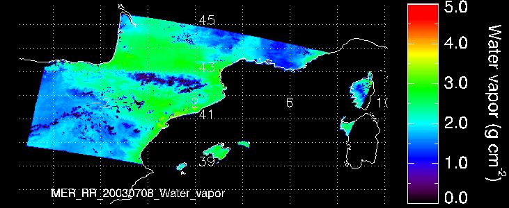

21 Sample maps Validation - CWV retrieval


22 Validation - Reflectance retrieval Comparison with CHRIS-PROBA data ASD vs CHRIS CHRIS vs MERIS

23 Validation - Reflectance retrieval Comparison with BAER BAER SCAPE-M
24 Validation - Reflectance retrieval Comparison with BAER λ~red
25 Validation - Reflectance retrieval Comparison with BAER λ~near-infrared
26 Contents I. Introduction II. III. Algorithm Theoretical Background Overall Validation IV. Results from Continental Water Bodies V. Summary and Conclusions
27 IV. Results from Continental Water Bodies SCAPE-M applied to MERIS FR data from dedicated field campaigns at reservoirs: CEDEX, Summer 2003: North-East Iberian Peninsula. 4 reservoirs with ground-based reflectance measurements. No perfect temporal co-location (+/- 1 day). Validation of the MERIS lake water processor (BEAM), Summer 2007: Iberian Peninsula: 5 reservoirs (x1,2 points) with ground-based atmospheric and reflectance measurements. Finland: 2 dates x 3 points, reflectance measurements (dark water).
28 Validation Inland Water Campaign CEDEX 2003 Tremp Terradets Canelles Rialb 19-June Reservoirs, +/-1day
29 Campaign CEDEX 2003 Validation Inland Water Tremp
30 Campaign CEDEX 2003 Validation Inland Water Terradets
31 Campaign CEDEX 2003 Validation Inland Water Canelles
32 Campaign CEDEX 2003 Validation Inland Water Rialb
33 Campaign CEDEX 2003 Validation Inland Water
 AOT")
34 Validation Inland Water Campaign MERIS Lakes 2007 Almendra Rosarito Alcántara Iznájar (+ Cuerda del Pozo and Albufera ) AOT Retrieval


35 Campaign MERIS Lakes 2007 Validation Inland Water 6-June-2007 Albufera


36 Campaign MERIS Lakes 2007 Validation Inland Water 28-June-2007 Cuerda del Pozo


37 Campaign MERIS Lakes 2007 Validation Inland Water 4-July-2007 Iznájar


38 Campaign MERIS Lakes 2007 Validation Inland Water 10-July-2007 Almendra


39 Campaign MERIS Lakes 2007 Validation Inland Water 13-July-2007 Rosarito
40 Validation Inland Water Comparison with BEAM Eutrophic Lakes Processor
41 Validation Inland Water Comparison with BEAM Eutrophic Lakes Processor
42 Courtesy of Sampsa Koponen Helsinki University of Technology Campaign Lake Processor 2007 Finland lakes Päijäne, Pyhäjärvi, Scape vs In situ Scape vs in situ Reflectance (sr-1) S1_insitu S1_scape S2_insitu S2_scape S3_insitu S3_scape Reflectance (sr-1) S1_insitu S1_scape S2_insitu S2_scape S3_insitu S3_scape Wavelength (nm) Wavelength (nm)
43 Contents I. Introduction II. III. Algorithm Theoretical Background Overall Validation IV. Results from Continental Water Bodies V. Summary and Conclusions
44 V. Summary and Conclusions SCAPE-M: atmospheric processor for MERIS L1b data over land and inland waters. Overall validation over land: >200 MERIS FR/RR images with ground-based measurements, AERONET data & other satellite-based products. Typical RMSE of AOT550~0.05 and CWV~0.2 gcm -2 Reflectance: good comparison with ground measurements, C/P & BAER.
45 V. Summary and Conclusions Validation extended to continental waters. Good performance in the retrieval of both reflectance level and spectral shape at eutrophic waters. Large reflectance errors at blue and NIR over dark water (ρ~1%). Future? Validation over coastal waters remaining. Room for improvement: sun-glint, polarisation & adjacency correction. Benefit from ESA processors?
46 Thank you for your attention!

47 Application of the SCAPE-M atmospheric correction algorithm to the processing of MERIS data over continental water bodies L. Guanter 1, J. A. Domínguez 2, L. Conde 2, A. Ruiz-Verdú 2, V. Estellés 3, R. Peña 2, J. Moreno 3 1 GFZ Potsdam (Germany) 2 CEDEX (Spain) 3 University of Valencia (Spain)
End-to-End Simulation of Sentinel-2 Data with Emphasis on Atmospheric Correction Methods
 End-to-End Simulation of Sentinel-2 Data with Emphasis on Atmospheric Correction Methods Luis Guanter 1, Karl Segl 2, Hermann Kaufmann 2 (1) Institute for Space Sciences, Freie Universität Berlin, Germany
Optical Theory Basics - 2 Atmospheric corrections and parameter retrieval
 Optical Theory Basics - 2 Atmospheric corrections and parameter retrieval Jose Moreno 3 September 2007, Lecture D1Lb2 OPTICAL THEORY-FUNDAMENTALS (2) Radiation laws: definitions and nomenclature Sources
SIMEC, An Environment Correction For MERIS Based On The NIR Similarity Spectrum
 SIMEC, An Environment Correction For MERIS Based On The NIR Similarity Spectrum Els Knaeps, Sindy Sterckx, Flemish Institute for Technological Research (VITO), Remote Sensing Unit (TAP), Boeretang 200,
Prototyping GOES-R Albedo Algorithm Based on MODIS Data Tao He a, Shunlin Liang a, Dongdong Wang a
 Prototyping GOES-R Albedo Algorithm Based on MODIS Data Tao He a, Shunlin Liang a, Dongdong Wang a a. Department of Geography, University of Maryland, College Park, USA Hongyi Wu b b. University of Electronic
Global and Regional Retrieval of Aerosol from MODIS
 Global and Regional Retrieval of Aerosol from MODIS Why study aerosols? CLIMATE VISIBILITY Presented to UMBC/NESDIS June 4, 24 Robert Levy, Lorraine Remer, Yoram Kaufman, Allen Chu, Russ Dickerson modis-atmos.gsfc.nasa.gov
Retrieval of crop characteristics from high resolution airborne scanner data
 Retrieval of crop characteristics from high resolution airborne scanner data K. Richter 1, F. Vuolo 2, G. D Urso 1, G. Fernandez 3 1 DIIAT, Facoltà di Agraria, Università degli studi di Napoli Federico
CHRIS Proba Workshop 2005 II
 CHRIS Proba Workshop 25 Analyses of hyperspectral and directional data for agricultural monitoring using the canopy reflectance model SLC Progress in the Upper Rhine Valley and Baasdorf test-sites Dr.
Operational use of the Orfeo Tool Box for the Venµs Mission
 Operational use of the Orfeo Tool Box for the Venµs Mission Thomas Feuvrier http://uk.c-s.fr/ Free and Open Source Software for Geospatial Conference, FOSS4G 2010, Barcelona Outline Introduction of the
Menghua Wang NOAA/NESDIS/STAR Camp Springs, MD 20746, USA
 Ocean EDR Product Calibration and Validation Plan Progress Report: VIIRS Ocean Color Algorithm Evaluations and Data Processing and Analyses Define a VIIRS Proxy Data Stream Define the required in situ
ICOL Improve Contrast between Ocean & Land
 - MEIS Level-1C eport D6 Issue: 1 ev.: 1 Page: 1 Project Title: Document Title: ICOL The MEIS Level-1C Version: 1.1 Author(s): Affiliation(s):. Santer, F. Zagolski ULCO, Université du Littoral Côte d Opale,
Sentinel-2 Calibration and Validation : from the Instrument to Level 2 Products
 Sentinel-2 Calibration and Validation : from the Instrument to Level 2 Products Vincent Lonjou a, Thierry Tremas a, Sophie Lachérade a, Cécile Dechoz a, Florie Languille a, Aimé Meygret a, Olivier Hagolle
TOA RADIANCE SIMULATOR FOR THE NEW HYPERSPECTRAL MISSIONS: STORE (SIMULATOR OF TOA RADIANCE)
") TOA RADIANCE SIMULATOR FOR THE NEW HYPERSPECTRAL MISSIONS: STORE (SIMULATOR OF TOA RADIANCE) Malvina Silvestri Istituto Nazionale di Geofisica e Vulcanologia In the frame of the Italian Space Agency (ASI)
TOA RADIANCE SIMULATOR FOR THE NEW HYPERSPECTRAL MISSIONS: STORE (SIMULATOR OF TOA RADIANCE) Malvina Silvestri Istituto Nazionale di Geofisica e Vulcanologia In the frame of the Italian Space Agency (ASI)
Seawater reflectance in the near-ir
 Seawater reflectance in the near-ir Maéva DORON David DOXARAN Simon BELANGER Marcel BABIN Laboratoire d'océanographie de Villefranche Seawater Reflectance in the Near-IR Doron, Doxaran, Bélanger & Babin
A Method Suitable for Vicarious Calibration of a UAV Hyperspectral Remote Sensor
 A Method Suitable for Vicarious Calibration of a UAV Hyperspectral Remote Sensor Hao Zhang 1, Haiwei Li 1, Benyong Yang 2, Zhengchao Chen 1 1. Institute of Remote Sensing and Digital Earth (RADI), Chinese
Motivation. Aerosol Retrieval Over Urban Areas with High Resolution Hyperspectral Sensors
 Motivation Aerosol etrieval Over Urban Areas with High esolution Hyperspectral Sensors Barry Gross (CCNY) Oluwatosin Ogunwuyi (Ugrad CCNY) Brian Cairns (NASA-GISS) Istvan Laszlo (NOAA-NESDIS) Aerosols
SENTINEL-2 SEN2COR: L2A PROCESSOR FOR USERS
 SENTINEL-2 SEN2COR: L2A PROCESSOR FOR USERS Jérôme Louis (1), Vincent Debaecker (1), Bringfried Pflug (2), Magdalena Main-Knorn (2), Jakub Bieniarz (2), Uwe Mueller-Wilm (3), Enrico Cadau (4), Ferran Gascon
A Generic Approach For Inversion And Validation Of Surface Reflectance and Aerosol Over Land: Application To Landsat 8 And Sentinel 2
 A Generic Approach For Inversion And Validation Of Surface Reflectance and Aerosol Over Land: Application To Landsat 8 And Sentinel 2 Eric Vermote NASA Goddard Space Flight Center, Code 619, Greenbelt,
A new simple concept for ocean colour remote sensing using parallel polarisation radiance
 Supplement Figures A new simple concept for ocean colour remote sensing using parallel polarisation radiance Xianqiang He 1, 3, Delu Pan 1, 2, Yan Bai 1, 2, Difeng Wang 1, Zengzhou Hao 1 1 State Key Laboratory
Improved Global Ocean Color using POLYMER Algorithm
 Improved Global Ocean Color using POLYMER Algorithm François Steinmetz 1 Didier Ramon 1 Pierre-Yves Deschamps 1 Jacques Stum 2 1 Hygeos 2 CLS June 29, 2010 ESA Living Planet Symposium, Bergen, Norway c
TOTAL SUSPENDED MATTER MAPS FROM CHRIS IMAGERY OF A SMALL INLAND WATER BODY IN OOSTENDE (BELGIUM)
") TOTAL SUSPENDED MATTER MAPS FROM IMAGERY OF A SMALL INLAND WATER BODY IN OOSTENDE (BELGIUM) Barbara Van Mol (1) and Kevin Ruddick (1) (1) Management Unit of the North Sea Mathematical Models (MUMM), Royal
TOTAL SUSPENDED MATTER MAPS FROM IMAGERY OF A SMALL INLAND WATER BODY IN OOSTENDE (BELGIUM) Barbara Van Mol (1) and Kevin Ruddick (1) (1) Management Unit of the North Sea Mathematical Models (MUMM), Royal
Data Mining Support for Aerosol Retrieval and Analysis:
 Data Mining Support for Aerosol Retrieval and Analysis: Our Approach and Preliminary Results Zoran Obradovic 1 joint work with Amy Braverman 2, Bo Han 1, Zhanqing Li 3, Yong Li 1, Kang Peng 1, Yilian Qin
THE SCIENTIFIC MODULES OF FLEX END-TO-END SIMULATOR: THE SCENE GENERATOR AND THE LEVEL-2 RETRIEVAL MODULES.
 THE SCIENTIFIC MODULES OF FLEX END-TO-END SIMULATOR: THE SCENE GENERATOR AND THE LEVEL-2 RETRIEVAL MODULES. N. Sabater (1), J.P. Rivera (1), C. Tenjo (1) ), J. Vicent (1), L. Alonso (1), J. Verrelst (1)
Algorithm development for aerosol retrieval and its validation based on combined use of polarization and radiance measurements
 Algorithm development for aerosol retrieval and its validation based on combined use of polarization and radiance measurements I. Sano, and CI team CIs : S. Mukai, M. Nakata, B. Holben, O. Dubovik, A.
Estimating forest parameters from top-of-atmosphere radiance data
 Estimating forest parameters from top-of-atmosphere radiance data V. Laurent*, W. Verhoef, J. Clevers, M. Schaepman *Contact: valerie.laurent@wur.nl Guest lecture, RS course, 8 th Decembre, 2010 Contents
Optical/Thermal: Principles & Applications
 Optical/Thermal: Principles & Applications Jose F. Moreno University of Valencia, Spain Jose.Moreno@uv.es Lecture D1T2 1 July 2013 23/07/2013 1 OPTICAL PRINCIPLES AND APPLICATIONS Information content of
IOCS San Francisco 2015 Uncertainty algorithms for MERIS / OLCI case 2 water products
 IOCS San Francisco 2015 Uncertainty algorithms for MERIS / OLCI case 2 water products Roland Doerffer Brockmann Consult The problem of optically complex water high variability of optical properties of
Atmospheric correction of hyperspectral ocean color sensors: application to HICO
 Atmospheric correction of hyperspectral ocean color sensors: application to HICO Amir Ibrahim NASA GSFC / USRA Bryan Franz, Zia Ahmad, Kirk knobelspiesse (NASA GSFC), and Bo-Cai Gao (NRL) Remote sensing
Improved MODIS Aerosol Retrieval using Modified VIS/MIR Surface Albedo Ratio Over Urban Scenes
 Improved MODIS Aerosol Retrieval using Modified VIS/MIR Surface Albedo Ratio Over Urban Scenes Min Min Oo, Matthias Jerg, Yonghua Wu Barry Gross, Fred Moshary, Sam Ahmed Optical Remote Sensing Lab City
Update on S3 SYN-VGT algorithm status PROBA-V QWG 4 24/11/2016
 ACRI-ST S3MPC 2014-2016 Update on S3 SYN-VGT algorithm status PROBA-V QWG 4 24/11/2016 Agenda Continuity with PROBA-V data - Evolution of S3 SYN / Creation of an alternative Proba-V like processing chain
SWIR/VIS Reflectance Ratio Over Korea for Aerosol Retrieval
 Korean Journal of Remote Sensing, Vol.23, No.1, 2007, pp.1~5 SWIR/VIS Reflectance Ratio Over Korea for Aerosol Retrieval Kwon Ho Lee*, Zhangqing Li*, Young Joon Kim** *Earth System Science Interdisciplinary
Calibration Techniques for NASA s Remote Sensing Ocean Color Sensors
 Calibration Techniques for NASA s Remote Sensing Ocean Color Sensors Gerhard Meister, Gene Eplee, Bryan Franz, Sean Bailey, Chuck McClain NASA Code 614.2 Ocean Biology Processing Group October 21st, 2010
MODIS Atmosphere: MOD35_L2: Format & Content
 Page 1 of 9 File Format Basics MOD35_L2 product files are stored in Hierarchical Data Format (HDF). HDF is a multi-object file format for sharing scientific data in multi-platform distributed environments.
Understanding The MODIS Aerosol Products
 Understanding The MODIS Aerosol Products Rich Kleidman Science Systems and Applications Rob Levy Science Systems and Applications Lorraine Remer NASA Goddard Space Flight Center Chistina Chu NASA Goddard
GRASP Algorithm: Retrieval of the detailed properties of atmospheric aerosol from PARASOL and other sensors
 GRASP Algorithm: Retrieval of the detailed properties of atmospheric aerosol from PARASOL and other sensors Oleg Dubovik (University of Lille-1, CNRS, France) GRASP team: P. Litvinov 1,T. Lapyonok 1, F.
HICO User Annual Report. Using HICO data for the preparation of the future EnMAP satellite mission
 August 31, 2012 HICO User Annual Report Using HICO data for the preparation of the future EnMAP satellite mission Nicole Pinnel 1, Rolf Richter 1, Slava Kiselev 2, Martin Bachmann 1 1 DLR, Earth Observation
Overview of the EnMAP Imaging Spectroscopy Mission
 Overview of the EnMAP Imaging Spectroscopy Mission L. Guanter, H. Kaufmann, K. Segl, S. Foerster, T. Storch, A. Mueller, U. Heiden, M. Bachmann, G. Rossner, C. Chlebek, S. Fischer, B. Sang, the EnMAP Science
CHRIS PROBA instrument
 CHRIS PROBA instrument Wout Verhoef ITC, The Netherlands verhoef @itc.nl 29 June 2009, D1L5 Contents Satellite and instrument Images Multi-angular analysis Toolbox CHRIS-PROBA PROBA-CHRIS Project for On-Board
CLOUD DETECTION FOR MERIS MULTISPECTRAL IMAGES
 CLOUD DETECTION FOR MERIS MULTISPECTRAL IMAGES Luis Gómez-Chova, Gustavo Camps-Valls, Julia Amorós, José D. Martín, Javier Calpe, Luis Alonso 2, Luis Guanter 2, Juan C. Fortea 2, and José Moreno 2 GPDS,
Quality assessment of RS data. Remote Sensing (GRS-20306)
") Quality assessment of RS data Remote Sensing (GRS-20306) Quality assessment General definition for quality assessment (Wikipedia) includes evaluation, grading and measurement process to assess design,
Quality assessment of RS data Remote Sensing (GRS-20306) Quality assessment General definition for quality assessment (Wikipedia) includes evaluation, grading and measurement process to assess design,
JAXA Himawari Monitor Aerosol Products. JAXA Earth Observation Research Center (EORC) September 2018
 September 2018") JAXA Himawari Monitor Aerosol Products JAXA Earth Observation Research Center (EORC) September 2018 1 2 JAXA Himawari Monitor JAXA has been developing Himawari-8 products using the retrieval algorithms
JAXA Himawari Monitor Aerosol Products JAXA Earth Observation Research Center (EORC) September 2018 1 2 JAXA Himawari Monitor JAXA has been developing Himawari-8 products using the retrieval algorithms
: Sentinel-2 MSI Level 2A Products Algorithm Theoretical Basis Document
 Customer : Contract No : WP No : ESRIN 21450/08/I-EC 1.1.5.1.2 Document Ref : Issue Date : Issue : S2PAD-ATBD-0001 13 April 2011 1.8 Title : Sentinel-2 MSI Level 2A Products Algorithm Theoretical Basis
Comparison of Full-resolution S-NPP CrIS Radiance with Radiative Transfer Model
 Comparison of Full-resolution S-NPP CrIS Radiance with Radiative Transfer Model Xu Liu NASA Langley Research Center W. Wu, S. Kizer, H. Li, D. K. Zhou, and A. M. Larar Acknowledgements Yong Han NOAA STAR
Infrared Scene Simulation for Chemical Standoff Detection System Evaluation
 Infrared Scene Simulation for Chemical Standoff Detection System Evaluation Peter Mantica, Chris Lietzke, Jer Zimmermann ITT Industries, Advanced Engineering and Sciences Division Fort Wayne, Indiana Fran
2017 Summer Course on Optical Oceanography and Ocean Color Remote Sensing. Introduction to Remote Sensing
 2017 Summer Course on Optical Oceanography and Ocean Color Remote Sensing Introduction to Remote Sensing Curtis Mobley Delivered at the Darling Marine Center, University of Maine July 2017 Copyright 2017
THE EFFECT OF TOPOGRAPHIC FACTOR IN ATMOSPHERIC CORRECTION FOR HYPERSPECTRAL DATA
 THE EFFECT OF TOPOGRAPHIC FACTOR IN ATMOSPHERIC CORRECTION FOR HYPERSPECTRAL DATA Tzu-Min Hong 1, Kun-Jen Wu 2, Chi-Kuei Wang 3* 1 Graduate student, Department of Geomatics, National Cheng-Kung University
Sentinel-3 Product Notice SYNergy
 Sentinel-3 Product Notice SYNergy Mission Sentinel 3-A Sensor SYNERGY products (combination of OLCI and SLSTR) Product SY_2_SYN SY_2_VGP SY_2_VG1 SY_2_V10 Product Notice ID S3A.PN-SYN-L2.02 Issue/Rev Date
IR-Signature of the MULDICON Configuration Determined by the IR-Signature Model MIRA
 DLR.de Folie 1 IR-Signature of the MULDICON Configuration Determined by the IR-Signature Model MIRA Erwin Lindermeir*, Markus Rütten DLR German Aerospace Center *Remote Sensing Technology Institute Institute
JAXA Himawari Monitor Aerosol Products. JAXA Earth Observation Research Center (EORC) August 2018
 August 2018") JAXA Himawari Monitor Aerosol Products JAXA Earth Observation Research Center (EORC) August 2018 1 JAXA Himawari Monitor JAXA has been developing Himawari 8 products using the retrieval algorithms based
JAXA Himawari Monitor Aerosol Products JAXA Earth Observation Research Center (EORC) August 2018 1 JAXA Himawari Monitor JAXA has been developing Himawari 8 products using the retrieval algorithms based
Monte Carlo Ray Tracing Based Non-Linear Mixture Model of Mixed Pixels in Earth Observation Satellite Imagery Data
 Monte Carlo Ray Tracing Based Non-Linear Mixture Model of Mixed Pixels in Earth Observation Satellite Imagery Data Verification of non-linear mixed pixel model with real remote sensing satellite images
Update on Pre-Cursor Calibration Analysis of Sentinel 2. Dennis Helder Nischal Mishra Larry Leigh Dave Aaron
 Update on Pre-Cursor Calibration Analysis of Sentinel 2 Dennis Helder Nischal Mishra Larry Leigh Dave Aaron Background The value of Sentinel-2 data, to the Landsat world, will be entirely dependent on
GOES-R AWG Radiation Budget Team: Absorbed Shortwave Radiation at surface (ASR) algorithm June 9, 2010
 algorithm June 9, 2010") GOES-R AWG Radiation Budget Team: Absorbed Shortwave Radiation at surface (ASR) algorithm June 9, 2010 Presented By: Istvan Laszlo NOAA/NESDIS/STAR 1 ASR Team Radiation Budget AT chair: Istvan Laszlo ASR
GOES-R AWG Radiation Budget Team: Absorbed Shortwave Radiation at surface (ASR) algorithm June 9, 2010 Presented By: Istvan Laszlo NOAA/NESDIS/STAR 1 ASR Team Radiation Budget AT chair: Istvan Laszlo ASR
UAV-based Remote Sensing Payload Comprehensive Validation System
 36th CEOS Working Group on Calibration and Validation Plenary May 13-17, 2013 at Shanghai, China UAV-based Remote Sensing Payload Comprehensive Validation System Chuan-rong LI Project PI www.aoe.cas.cn
PV-LAC: D-2-A3 ATBD Activity 3 & D-3-A3 IODD Activity 3
 Delivery report PV-LAC: advances Land, Aerosol and Coastal products for Proba-V PV-LAC: D-2-A3 ATBD Activity 3 & D-3-A3 IODD Activity 3 Sindy Sterckx, Nitin Bhatia November 2016 Distribution List DISTRIBUTION
GEOG 4110/5100 Advanced Remote Sensing Lecture 2
 GEOG 4110/5100 Advanced Remote Sensing Lecture 2 Data Quality Radiometric Distortion Radiometric Error Correction Relevant reading: Richards, sections 2.1 2.8; 2.10.1 2.10.3 Data Quality/Resolution Spatial
MERIS US Workshop. Vicarious Calibration Methods and Results. Steven Delwart
 MERIS US Workshop Vicarious Calibration Methods and Results Steven Delwart Presentation Overview Recent results 1. CNES methods Deserts, Sun Glint, Rayleigh Scattering 2. Inter-sensor Uyuni 3. MOBY-AAOT
Algorithm Theoretical Basis Document (ATBD) MERIS Regional Coastal and Lake Case 2 Water Project Atmospheric Correction ATBD
 MERIS Regional Coastal and Lake Case 2 Water Project Atmospheric Correction ATBD") DOC: GKSS-KOF--ATBD01 Name: Case II ATBD-ATMO Page: 1 Algorithm Theoretical Basis Document (ATBD) Regional Coastal and Lake Case 2 Water Project Version 1.0, 18. May 2008 Roland Doerffer & Helmut Schiller
DOC: GKSS-KOF--ATBD01 Name: Case II ATBD-ATMO Page: 1 Algorithm Theoretical Basis Document (ATBD) Regional Coastal and Lake Case 2 Water Project Version 1.0, 18. May 2008 Roland Doerffer & Helmut Schiller
PARAMETERISATION OF AN AUTOMIZED PROCESSING CHAIN FOR MERIS DATA OF SWISS LAKES, AT THE EXAMPLE OF LAKE CONSTANCE
 PARAMETERISATION OF AN AUTOMIZED PROCESSING CHAIN FOR MERIS DATA OF SWISS LAKES, AT THE EXAMPLE OF LAKE CONSTANCE D. Odermatt (1), T. Heege (2), J. Nieke (1), M. Kneubühler (1), K.I. Itten (1) (1) Remote
De-Shadowing of Satellite/Airborne Multispectral and Hyperspectral Imagery
 De-Shadowing of Satellite/Airborne Multispectral and Hyperspectral Imagery R. Richter DLR, German Aerospace Center Remote Sensing Data Center D-82234 Wessling GERMANY ABSTRACT A de-shadowing technique
OMAERO README File. Overview. B. Veihelmann, J.P. Veefkind, KNMI. Last update: November 23, 2007
 OMAERO README File B. Veihelmann, J.P. Veefkind, KNMI Last update: November 23, 2007 Overview The OMAERO Level 2 data product contains aerosol characteristics such as aerosol optical thickness (AOT), aerosol
Uncertainties in the Products of Ocean-Colour Remote Sensing
 Chapter 3 Uncertainties in the Products of Ocean-Colour Remote Sensing Emmanuel Boss and Stephane Maritorena Data products retrieved from the inversion of in situ or remotely sensed oceancolour data are
Kohei Arai 1 Graduate School of Science and Engineering Saga University Saga City, Japan
 Sensitivity Analysis and Error Analysis of Reflectance Based Vicarious Calibration with Estimated Aerosol Refractive Index and Size Distribution Derived from Measured Solar Direct and Diffuse Irradiance
Challenges with atmospheric corrections over Land
 Challenges with atmospheric corrections over Land Eric Vermote NASA GSFC Code 619 Eric.f.vermote@nasa.gov. A Land Climate Data Record Multi instrument/multi sensor Science Quality Data Records used to
Name Company Function Signature Date
 Page : i of 1 Title: MERMAID data format Doc. no: QWG-MER-MERMAID-DF-02 Issue: 2 Revision: 3 Date: 22/03/2012 Name Company Function Signature Date Prepared by: C. Mazeran ACRI-ST W.P. Manager 22/03/2012
DEVELOPMENT OF CLOUD AND SHADOW FREE COMPOSITING TECHNIQUE WITH MODIS QKM
 DEVELOPMENT OF CLOUD AND SHADOW FREE COMPOSITING TECHNIQUE WITH MODIS QKM Wataru Takeuchi Yoshifumi Yasuoka Institute of Industrial Science, University of Tokyo, Japan 6-1, Komaba 4-chome, Meguro, Tokyo,
Verification of MSI Low Radiance Calibration Over Coastal Waters, Using AERONET-OC Network
 Verification of MSI Low Radiance Calibration Over Coastal Waters, Using AERONET-OC Network Yves Govaerts and Marta Luffarelli Rayference Radiometric Calibration Workshop for European Missions ESRIN, 30-31
Class 11 Introduction to Surface BRDF and Atmospheric Scattering. Class 12/13 - Measurements of Surface BRDF and Atmospheric Scattering
 University of Maryland Baltimore County - UMBC Phys650 - Special Topics in Experimental Atmospheric Physics (Spring 2009) J. V. Martins and M. H. Tabacniks http://userpages.umbc.edu/~martins/phys650/ Class
OCEANSAT-2 OCEAN COLOUR MONITOR (OCM-2)
") OCEANSAT-2 OCEAN COLOUR MONITOR (OCM-2) Update of post launch vicarious, lunar calibrations & current status Presented by Prakash Chauhan Space Applications Centre Indian Space Research Organistaion Ahmedabad-
OCEANSAT-2 OCEAN COLOUR MONITOR (OCM-2) Update of post launch vicarious, lunar calibrations & current status Presented by Prakash Chauhan Space Applications Centre Indian Space Research Organistaion Ahmedabad-
Aerosol Remote Sensing from PARASOL and the A-Train
 Aerosol Remote Sensing from PARASOL and the A-Train J.-F. Léon, D. Tanré, J.-L. Deuzé, M. Herman, P. Goloub, P. Lallart Laboratoire d Optique Atmosphérique, France A. Lifermann Centre National d Etudes
Spectral Extinction Coefficient measurements of inland waters
 Spectral Extinction Coefficient measurements of inland waters M. Potes, M. J. Costa, R. Salgado and P. Le Moigne Évora Geophysics Centre, PORTUGAL CNRM/GMME/MOSAYC Météo-France, FRANCE Third Workshop on
REMOTE SENSING OF VERTICAL IOP STRUCTURE
 REMOTE SENSING OF VERTICAL IOP STRUCTURE W. Scott Pegau College of Oceanic and Atmospheric Sciences Ocean. Admin. Bldg. 104 Oregon State University Corvallis, OR 97331-5503 Phone: (541) 737-5229 fax: (541)
Airborne Hyperspectral Imaging Using the CASI1500
 Airborne Hyperspectral Imaging Using the CASI1500 AGRISAR/EAGLE 2006, ITRES Research CASI 1500 overview A class leading VNIR sensor with extremely sharp optics. 380 to 1050nm range 288 spectral bands ~1500
Uncertainties in ocean colour remote sensing
 ENMAP Summer School on Remote Sensing Data Analysis Uncertainties in ocean colour remote sensing Roland Doerffer Retired from Helmholtz Zentrum Geesthacht Institute of Coastal Research Now: Brockmann Consult
Evaluation of Satellite Ocean Color Data Using SIMBADA Radiometers
 Evaluation of Satellite Ocean Color Data Using SIMBADA Radiometers Robert Frouin Scripps Institution of Oceanography, la Jolla, California OCR-VC Workshop, 21 October 2010, Ispra, Italy The SIMBADA Project
Atmospheric / Topographic Correction for Airborne Imagery. (ATCOR-4 User Guide, Version 7.0.3, March 2016)
") Atmospheric / Topographic Correction for Airborne Imagery (ATCOR-4 User Guide, Version 7.0.3, March 2016) R. Richter 1 and D. Schläpfer 2 1 DLR - German Aerospace Center, D - 82234 Wessling, Germany 2
Atmospheric / Topographic Correction for Airborne Imagery (ATCOR-4 User Guide, Version 7.0.3, March 2016) R. Richter 1 and D. Schläpfer 2 1 DLR - German Aerospace Center, D - 82234 Wessling, Germany 2
The NIR- and SWIR-based On-orbit Vicarious Calibrations for VIIRS
 The NIR- and SWIR-based On-orbit Vicarious Calibrations for VIIRS Menghua Wang NOAA/NESDIS/STAR E/RA3, Room 3228, 5830 University Research Ct. College Park, MD 20746, USA Menghua.Wang@noaa.gov Workshop
Recent Progress of BaoTou Comprehensive Cal&Val Site. Prof. Chuan-rong Li. Academy of Opto-Electronics(AOE), Chinese Academy of Sciences
, Chinese Academy of Sciences") LANDNET WG meeting #4 CEOS/WGCV-41 Plenary Recent Progress of BaoTou Comprehensive Cal&Val Site Prof. Chuan-rong Li Academy of Opto-Electronics(AOE), Chinese Academy of Sciences National Remote Sensing
LANDNET WG meeting #4 CEOS/WGCV-41 Plenary Recent Progress of BaoTou Comprehensive Cal&Val Site Prof. Chuan-rong Li Academy of Opto-Electronics(AOE), Chinese Academy of Sciences National Remote Sensing
Leaf Area Index - Fraction of Photosynthetically Active Radiation 8-Day L4 Global 1km MOD15A2
 Leaf Area Index - Fraction of Photosynthetically Active Radiation 8-Day L4 Global 1km MOD15A2 The level-4 MODIS global Leaf Area Index (LAI) and Fraction of Photosynthetically Active Radiation (FPAR) product
De-shadowing of satellite/airborne imagery
 International Journal of Remote Sensing Vol. 26, No. 15, 10 August 2005, 3137 3148 De-shadowing of satellite/airborne imagery R. RICHTER* and A. MÜLLER DLR, German Aerospace Center, Remote Sensing Data
Preprocessed Input Data. Description MODIS
 Preprocessed Input Data Description MODIS The Moderate Resolution Imaging Spectroradiometer (MODIS) Surface Reflectance products provide an estimate of the surface spectral reflectance as it would be measured
SEOM s Sentinel-3/OLCI project CAWA: advanced GRASP aerosol retrieval
 SEOM s Sentinel-3/OLC project CAWA: advanced GRASP aerosol retrieval Oleg Dubovik1, Pavel Litvinov1, Xin Huang1, Michael Aspetsberger2, David Fuertes3, Carsten Brockmann4, And Jürgen Fischer5. 1- University
Retrieval of spectral aerosol optical thickness over land using ocean color sensors MERIS and SeaWiFS
 doi:10.5194/amt-4-151-2011 Author(s) 2011. CC Attribution 3.0 License. Atmospheric Measurement Techniques Retrieval of spectral aerosol optical thickness over land using ocean color sensors MERIS and SeaWiFS
Nonlinear Mixing Model of Mixed Pixels in Remote Sensing Satellite Images Taking Into Account Landscape
 Vol. 4, No., 23 Nonlinear Mixing Model of Mixed Pixels in Remote Sensing Satellite Images Taking Into Account Landscape Verification of the proposed nonlinear pixed pixel model through simulation studies
GEOBIA for ArcGIS (presentation) Jacek Urbanski
 Jacek Urbanski") GEOBIA for ArcGIS (presentation) Jacek Urbanski INTEGRATION OF GEOBIA WITH GIS FOR SEMI-AUTOMATIC LAND COVER MAPPING FROM LANDSAT 8 IMAGERY Presented at 5th GEOBIA conference 21 24 May in Thessaloniki.
GEOBIA for ArcGIS (presentation) Jacek Urbanski INTEGRATION OF GEOBIA WITH GIS FOR SEMI-AUTOMATIC LAND COVER MAPPING FROM LANDSAT 8 IMAGERY Presented at 5th GEOBIA conference 21 24 May in Thessaloniki.
A Survey of Modelling and Rendering of the Earth s Atmosphere
 Spring Conference on Computer Graphics 00 A Survey of Modelling and Rendering of the Earth s Atmosphere Jaroslav Sloup Department of Computer Science and Engineering Czech Technical University in Prague
PICSCAR Status Radiometric Calibration Workshop for European Missions
 PICSCAR-PPT-022-MAG PUTTING KNOWLEDGE ON THE MAP PICSCAR Status Radiometric Calibration Workshop for European Missions Béatrice Berthelot (Magellium) Patrice Henry (CNES) 1 Characterisation of PICS PICS
Validation of MODTRAN 5.3 sea surface radiance computations
 Validation of MODTRAN 5.3 sea surface radiance computations Vincent Ross*, Denis Dion** et Daniel St-Germain** * With AEREX Avionique Inc., ** With DRDC Valcartier ITBM&S, Toulouse France. June 27th 211
Retrieval of Aerosol and Cloud Properties using the ATSR Dual and Single View algorithms
 Retrieval of Aerosol and Cloud Properties using the ATSR Dual and Single View algorithms Gerrit de Leeuw 1,2, Larisa Sogacheva 1, Pekka Kolmonen 1, Giulia Saponaro 1, Timo H. Virtanen 1, Edith Rodriguez
SPEEDING UP THE SIMULATION OF VEGETATION FLUORESCENCE THROUGH EMULATION: PRACTICAL APPLICATIONS FOR FLEX DATA PROCESSING
 SPEEDING UP THE SIMULATION OF VEGETATION FLUORESCENCE THROUGH EMULATION: PRACTICAL APPLICATIONS FOR FLEX DATA PROCESSING Jochem Verrelst, Juan Pablo Rivera & Jose Moreno Image Processing Laboratory, Univ.
Sentinel-1 Toolbox. TOPS Interferometry Tutorial Issued May 2014
 Sentinel-1 Toolbox TOPS Interferometry Tutorial Issued May 2014 Copyright 2015 Array Systems Computing Inc. http://www.array.ca/ https://sentinel.esa.int/web/sentinel/toolboxes Interferometry Tutorial
MTG-FCI: ATBD for Clear Sky Reflectance Map Product
 MTG-FCI: ATBD for Clear Sky Reflectance Map Product Doc.No. Issue : : v2 EUMETSAT Eumetsat-Allee 1, D-64295 Darmstadt, Germany Tel: +49 6151 807-7 Fax: +49 6151 807 555 Date : 14 January 2013 http://www.eumetsat.int
Algorithm Theoretical Basis Document (ATBD) for Calibration of space sensors over Rayleigh Scattering : Initial version for LEO sensors
 for Calibration of space sensors over Rayleigh Scattering : Initial version for LEO sensors") 1 Algorithm Theoretical Basis Document (ATBD) for Calibration of space sensors over Rayleigh Scattering : Initial version for LEO sensors Bertrand Fougnie, Patrice Henry CNES 2 nd July, 2013 1. Introduction
1 Algorithm Theoretical Basis Document (ATBD) for Calibration of space sensors over Rayleigh Scattering : Initial version for LEO sensors Bertrand Fougnie, Patrice Henry CNES 2 nd July, 2013 1. Introduction
[Sakthivel *, 5(11): November 2018] ISSN DOI /zenodo Impact Factor
![[Sakthivel *, 5(11): November 2018] ISSN DOI /zenodo Impact Factor](/thumbs/91/105145249.jpg "[Sakthivel *, 5(11): November 2018] ISSN DOI /zenodo Impact Factor") GLOBAL JOURNAL OF ENGINEERING SCIENCE AND RESEARCHES ATMOSPHERIC CORRECTION OF VISIBLE CHANNEL OF SATELLITE IMAGE FROM INSAT-3D IMAGER USING SECOND SIMULATION OF THE SATELLITE SIGNAL IN THE SOLAR SPECTRUM
GLOBAL JOURNAL OF ENGINEERING SCIENCE AND RESEARCHES ATMOSPHERIC CORRECTION OF VISIBLE CHANNEL OF SATELLITE IMAGE FROM INSAT-3D IMAGER USING SECOND SIMULATION OF THE SATELLITE SIGNAL IN THE SOLAR SPECTRUM
Atmospheric / Topographic Correction for Satellite Imagery. (ATCOR-2/3 User Guide, Version 9.2.0, March 2018)
") Atmospheric / Topographic Correction for Satellite Imagery (ATCOR-2/3 User Guide, Version 9.2.0, March 2018) R. Richter 1 and D. Schläpfer 2 1 DLR - German Aerospace Center, D - 82234 Wessling, Germany
Atmospheric / Topographic Correction for Satellite Imagery (ATCOR-2/3 User Guide, Version 9.2.0, March 2018) R. Richter 1 and D. Schläpfer 2 1 DLR - German Aerospace Center, D - 82234 Wessling, Germany
Kohei Arai 1 1Graduate School of Science and Engineering Saga University Saga City, Japan. Kenta Azuma 2 2 Cannon Electronics Inc.
 Method for Surface Reflectance Estimation with MODIS by Means of Bi-Section between MODIS and Estimated Radiance as well as Atmospheric Correction with Skyradiometer Kohei Arai 1 1Graduate School of Science
MERIS land products. Principles & validation. F. Baret, M. Weiss, K. Pavageau, D. Béal, B. Berthelot, M. Huc, J. Moreno, C. Gonzales & P.
 MERIS land products LAI, fapar, fcover Principles & validation F. Baret, M. Weiss, K. Pavageau, D. Béal, B. Berthelot, M. Huc, J. Moreno, C. Gonzales & P. Regner MERIS (A)ATSR user workshop - Frascati
Shallow-water Remote Sensing: Lecture 1: Overview
 Shallow-water Remote Sensing: Lecture 1: Overview Curtis Mobley Vice President for Science and Senior Scientist Sequoia Scientific, Inc. Bellevue, WA 98005 curtis.mobley@sequoiasci.com IOCCG Course Villefranche-sur-Mer,
An ATBD for the ENVISAT radiometer MERIS
 An ATBD for the ENVISAT radiometer MERIS Determination of aerosol optical thickness over land surfaces, using Bremen osol Retrieval (BAER) and its applications to atmospheric correction over lands W VON
Projet PNTS SPACTO. SPatial Atmospheric Correction over Turbid Ocean. Julien Brajard
 Projet PNTS SPACTO SPatial Atmospheric Correction over Turbid Ocean Julien Brajard Outline Context Achievements Perpectives Context Signal measured by the radiometer water-leaving reflectance Atmospheric
UV Remote Sensing of Volcanic Ash
 UV Remote Sensing of Volcanic Ash Kai Yang University of Maryland College Park WMO Inter-comparison of Satellite-based Volcanic Ash Retrieval Algorithms Workshop June 26 July 2, 2015, Madison, Wisconsin
Sentinel-3 OLCI: Status
 Sentinel-3 OLCI: Status Jens Nieke, F. Borde, C. Mavrocordatos OLCI Status 26 Nov 2013 ESRIN 1 Outline Background OLCI development status Assembly, Testing & Integration (AIT) Camera EM and FM test results