GeoServer, The Open Source Solution for the interoperable management of geospatial data
|
|
|
- Amie Merritt
- 5 years ago
- Views:
Transcription

1 GeoServer, The Open Source Solution for the interoperable management of geospatial data Ing. Andrea Aime, GeoSolutions Ing. Simone Giannecchini, GeoSolutions
2 Outline Who is GeoSolutions? Quick intro to GeoServer What s new in the 2.2.x series What s new in the 2.3.x series What s cooking for the 2.4.x series
3 Founded in Italy in late 2006 Expertise GeoSolutions Image Processing, GeoSpatial Data Fusion Java, Java Enterprise, C++, Python JPEG2000, JPIP, Advanced 2D visualization Supporting/Developing FOSS4G projects GeoTools, GeoServer GeoNetwork, GeoBatch, MapStore ImageIO-Ext and more: Focus on Consultancy PAs, NGOs, private companies, etc
4 GeoServer quick intro


5 GeoServer GeoSpatial enterprise gateway Java Enterprise Management and Dissemination of raster and vector data Standards compliant OGC WCS 1.0, (RI), 2.0 in the pipeline OGC WFS 1.0, 1.1 (RI), 2.0 OGC WMS 1.1.1, 1.3 OGC WPS Google Earth/Maps support KML, GeoSearch, etc..

 Styled maps Raw vector data Raw raster data PNG, GIF JPEG TIFF, GeoTIFF SVG, PDF KML/KMZ Shapefile GML2 GML3 GeoRSS GeoJSON")
6 Formats and Protocols GeoServer Shapefile PostGIS Oracle H2 DB2 SQL Server MySql Spatialite GeoCouch ArcSDE WFS Vector files DBMS Servers WMS Google WFS 1.0, 1.1, 2.0 WPS WCS GeoTIFF WMS ArcGrid GTopo30 Img+world Mosaic Raster files MrSID JPEG 2000 ECW,Pyramid, Oracle GeoRaster, PostGis Raster GWC (WMTS, TMS, WMS-C) Styled maps Raw vector data Raw raster data PNG, GIF JPEG TIFF, GeoTIFF SVG, PDF KML/KMZ Shapefile GML2 GML3 GeoRSS GeoJSON CSV/XLS GeoTIFF ArcGrid GTopo30 Img+World KML superoverlays Google maps tiles OGC tiles OSGEO tiles

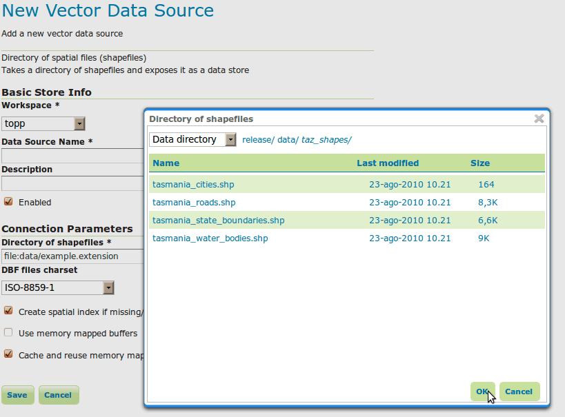
7 Administration GUI
8 RESTful Configuration Programmatic configuration of layers via REST calls Workspaces, Data stores / coverage stores Layers and Styles, Service configurations Freemarker templates (incoming) Exposing internal configuration to remote clients Ajax - JavaScript friendly Various client libraries available in different languages (Java, Python, Ruby, ). Example, geoserver-manager:
9 Dissemination of Maps WMS Fusing raster and vector data seamlessly Rule/scale driven rendering WMS and 1.3 support SLD Basic support for SLD 1.1 and SE 1.1 Full support for SLD 1.0 CSS extension for compact styling Many rendering extensions available

10 Rendering

11 Rendering: real world units <Rule> <LineSymbolizer uom=" <Stroke> <CssParameter name="stroke-width"> <ogc:literal>5</ogc:literal> </CssParameter> </Stroke> </LineSymbolizer> </Rule>

12 GeoWebCache Integration GeoServer GeoWebCache Persistent raster/kml tile cache Direct calls to GeoServer rendering engine Support for layers modified through WFT-T Support for various tile protocols GMap, Gearth OpenLayers, VEarth, Bing Speed-up factor 10/100 Disk quota support


13 KML/KMZ TEMPORAL SERIES KML EXTRUDE KML SUPEROVERLAY
14 WFS Dissemination and filtering of vector data WFS 1.0, 1.1 and 2.0 (since 2.2.0) Transaction and paging available in all versions Simplified filtering via CQL Formats: GML 2, 3.1 and 3.2 CSV, Excel spreadsheet, GeoRSS, GeoJSON Shapefile (zipped) Any other format supported by ogr2ogr (configurable)

15 Complex Feature* Application/community schemas Complex Features Attributes as sub-features Attributes as list of features Tree-like structure Mixing in a single tree hererogeneous data sources
16 WCS Raster data dissemination Raw raster data useful for analysis, no maps! Support for TIME and ELEVATION (via ImageMosaic plugin) WCS 1.0 and Output formats GeoTiff, ArcGrid GDAL based formats under discussion Extensions ELEVATION as band management
17 WPS WPS 1.0 Official Extension Raster and Vector data support High performance processes (raster/vector statistics, raster/vector format conversions and more) Integrated WPS Direct access to data sources Automatic publishing of results as new layers Embedding processes into SLD styles (rendering transformation, since 2.2.0)
18 What s new in 2.2.x


19 Virtual services Expose different OGC services per workspace Styles and layer groups per workspace Have different administrators per workspace multi-tenancy

20 Referencing news Support for NTv2 and NADCON grids high accuracy datum transformations Test and inspect re-projection interactively:

21 Impersonation in data access Use the current GeoServer user to access DBMS contents Tighten security also at the DBMS level Useful for high security setups WMS/WFS client GeoServer GeoServer user: X Connection pool user: impersonating DBMS user X DBMS


22 WMS: PNG8 with alpha Support for paletted PNG with alpha transparency Best of both worlds: compact but good looking Good quality, yet usable in interactive setups


23 WMS: TIME and ELEVATION TIME = T Z ELEVATION = 0.0 FeatureType Editor


24 WMS: Rendering Transformations On-the-fly data transformations Calling spatial analysis processes from SLD docs Optimized for performance Examples: on the fly contour lines, heat maps, point clustering, point interpolation, GCP based image rectification

25 Improved GWC integration Custom gridset definition Per layer caching configuration
 Joins (scalar,")

26 WFS: 2.0 and XSLT WFS 2.0 GML 3.2 Paging (back-ported to other versions) Joins (scalar, temporal, spatial) between feature types Stored queries XSLT output format: GML 2.X/3.X XLST engine txt Custom xml HTML Custom XSL sheet KML

27 WPS: asynchronous calls Asynchronous WPS support for long running processes Client WPS protocol handler WPS executor Execute Status poll Status poll Status? Internal submit Update status Update status Write results Results
28 Security: Authentication Pluggable user sources, available out of the box: LDAP, DBMS Pluggable authentication mechanisms, available out of the box: BASIC/DIGEST HTTP, CAS Possible to integrate with other mechanisms and in-house solutions Available since 2.2.0, before only basic HTTP auth + simple text file for users
29 What s new in 2.3.x
 Database based implementation")

30 Database configuration backend Pluggable configuration backends In-memory implementation + XML storage (current one) Database based implementation (as a community module) Pluggable, add your own (any takers for a NoSQL elastic implementation?) GeoServer config and catalog In-memory DBMS NoSQL?


31 GWC clustering Improved clustering for GWC in 1.4.x: Metastore removed Disk quota can work off a central DBMS Distributed locks, avoid concurrent computation of same tile at the same time Active/active clustering of GWC now possible Load balancer GWC1 GWC2 Tile storage Disk quota
32 CSW Wow, catalogue services in GeoServer! Catalog Service for the Web Pluggable record backend Pluggable record type support Not a replacement for a full-fledged GeoNetwork (not at the moment, at least) CSW protocol handler Dublin core support ebrim support ISO support Record type plugins GeoServer config backend Simple DC backend Vendor specific bridge Record sources
33 Current implementation CSW Demo backend with Dublin Core record support, passes CITE certifications tests ISO + Dublin core backend reporting layers in the GeoServer configuration, in development ebrim (Earth Observation profile) implementation plus proxy to a in-house, vendor specific catalog (proxy front-end model) Currently a community module will be graduated to extension once the ISO backend over the GeoServer own config is completed
34 WCS 2.0 WCS 2.0 implementation with extensions: Range subsetting Scaling and interpolation CRS (reprojection) GeoTiff & NetCDF encoding Earth Observation profile support Temporal series Exposing mosaic structure EO metadata describing sensors NetCDF support as both input and output Sponsors DLR (German spatial agency) EUMETSAT (European operational satellite agency for monitoring weather, climate and the environment)
35 Other Enhancements LayerGroups WPS Process Selection WMS Addition Dimensions Monitoring Extension Extensive JSONP Support Security Subsystem Improvements
36 What s cooking for 2.4.x

37 WMS EO Earth Observation profile support Temporal series Exposing mosaic structure EO metadata describing sensors

38 Spatiotemporal Raster Management NetCDF support Improve existing NetCDF/CF input format, support CF convention and make sure the samples provided by DLR/EUMETSAT can be read Expose NetCDF internal data as a set of 2D slices Write new NetCDF/CF output format for GeoServer

39 Spatiotemporal Raster Management Add REST support to expose a image mosaic internal structure Dimensions Granules Dimensions: list, edit, create, remove /workspaces/<ws>/coveragestores/<cs>/coverages/<mosaic>/dimensions /workspaces/<ws>/coveragestores/<cs>/coverages/<mosaic>/dimensions/<dimension>[.format] TODO paging and query of dimension domain Granules: list, edit, create, remove /workspaces/<ws>/coveragestores/<cs>/coverages/<mosaic>/index /workspaces/<ws>/coveragestores/<cs>/coverages/<mosaic>/index/pagen /workspaces/<ws>/coveragestores/<cs>/coverages/<mosaic>/index/pagen/granulem


40 The End Questions?
OpenData and INSPIRE with GeoServer, GeoNetwork and MapStore: lessons learned from real-world use cases
 OpenData and INSPIRE with GeoServer, GeoNetwork and MapStore: lessons learned from real-world use cases Ing. Simone Giannecchini, GeoSolutions Silvana Griffa, CSI Piemonte Giovanni Menduni, City of Florence
Creare SDI INSPIRE Ready con GeoNetwork e GeoServer
 Creare SDI INSPIRE Ready con GeoNetwork e GeoServer Ing. Andrea Aime, GeoSolutions Ing. Simone Giannecchini, GeoSolutions Ing. Emanuele Tajariol, GeoSolutions Outline Who is GeoSolutions? What GeoServer
[ ]..,ru. GeoServer Beginner's Guide. open source^ software server. Share and edit geospatial data with this open source.
![[ ]..,ru. GeoServer Beginner's Guide. open source^ software server. Share and edit geospatial data with this open source.](/thumbs/80/80955530.jpg "[ ]..,ru. GeoServer Beginner's Guide. open source^ software server. Share and edit geospatial data with this open source.") GeoServer Beginner's Guide Share and edit geospatial data with this open source software server Stefano lacovella Brian Youngblood [ ]..,ru open source^ PUBLISHING community experience distilled BIRMINGHAMMUMBAI
GeoServer Beginner's Guide Share and edit geospatial data with this open source software server Stefano lacovella Brian Youngblood [ ]..,ru open source^ PUBLISHING community experience distilled BIRMINGHAMMUMBAI
MapStore create, save and share maps and mashups. Dott. Ing. Mauro Bartolomeoli, GeoSolutions Ing. Simone Giannecchini, GeoSolutions
 MapStore create, save and share maps and mashups Dott. Ing. Mauro Bartolomeoli, GeoSolutions Ing. Simone Giannecchini, GeoSolutions Outline About GeoSolutions MapStore Introduction Demo Standards Architecture
Open source technologies and INSPIRE network services in Slovak environmental agency
 Open source technologies and INSPIRE network services in Slovak environmental agency Peter Mozolík, Martin Koška, Marek Žiačik, Martin Tuchyňa Slovak Environmental Agency (SEA) SEA role within slovak SDI
MapStore create, save and share maps and mashups. Ing. Alejandro Díaz, GeoSolutions
 MapStore create, save and share maps and mashups Ing. Alejandro Díaz, GeoSolutions Outline About GeoSolutions MapStore Introduction Demo Standards Architecture Tools Implementations GeoSolutions Founded
Web Map Servers. Mark de Blois. Septembre 2016
 Web Map Servers Mark de Blois Septembre 2016 Learning Objectives After this lecture you will be able to understand web map servers as used in Web-GIS applications Introduction A Web Map Server is a computer
Leveraging OGC Services in ArcGIS Server. Satish Sankaran, Esri Yingqi Tang, Esri
 Leveraging OGC Services in ArcGIS Server Satish Sankaran, Esri Yingqi Tang, Esri GIS Creating and Managing Geo Information Products - Proprietary - Open Specifications - Standards Dissemination of Geo
Implementing Web GIS Solutions
 Implementing Web GIS Solutions using open source software Karsten Vennemann Seattle Talk Overview Talk Overview Why and What What is Open Source (GIS)? Why use it? Application Components Overview of Web
Development of Java Plug-In for Geoserver to Read GeoRaster Data. 1. Baskar Dhanapal CoreLogic Global Services Private Limited, Bangalore
 Development of Java Plug-In for Geoserver to Read GeoRaster Data 1. Baskar Dhanapal CoreLogic Global Services Private Limited, Bangalore 2. Bruce Thelen CoreLogic Spatial Solutions, Austin, USA 3. Perumal
GeoServer in production We do it, here it is how! Ing. Andrea Aime Ing. Simone Giannecchini GeoSolutions
 GeoServer in production We do it, here it is how! Ing. Andrea Aime Ing. Simone Giannecchini GeoSolutions GeoSolutions Founded in Italy in late 2006 Expertise Image Processing, GeoSpatial Data Fusion Java,
Leveraging OGC Standards on ArcGIS Server
 Leveraging OGC Standards on ArcGIS Server Satish Sankaran Interoperability and Standards Team James Michel III ESRI Intel Team ArcGIS Server Complete Interoperable Server-Based GIS Desktop Explorer Web
OPEN SOURCE SOLUTIONS FOR SURVEYORS
 2 nd Sabah International Surveyors Congress 11 th 12 th March 2014 OPEN SOURCE SOLUTIONS FOR SURVEYORS Presented By : Sr Alexander Chong Director, Jurukur Antarabangsa The Benefits Of Closed Proprietary
Leveraging OGC Services in ArcGIS Server. Satish Sankaran Yingqi Tang
 Leveraging OGC Services in ArcGIS Server Satish Sankaran ssankaran@esri.com Yingqi Tang ytang@esri.com Agenda Interoperability Enablers OGC and esri OGC Web Services ArcGIS and OGC Web Services - @ version
Introduction to GeoServer
 Tutorial ID: This tutorial has been developed by BVIEER as part of the IGET web portal intended to provide easy access to geospatial education. This tutorial is released under the Creative Commons license.
Carmenta Server Product Description
 White paper Carmenta Server Product Description Carmenta AB, Tel +46-31-775 57 00, www.carmenta.com P315 121RD, 2010 Carmenta reserves the right to change the specifications at any time and without notice.
Next generation of raster support for the GeoTools-GeoServer stack
 Next generation of raster support for the GeoTools-GeoServer stack Dott. Ing Simone Giannecchini (GeoSolutions), Ing. Alessio Fabiani (GeoSolutions), Dott. Ing. Daniele Romagnoli (GeoSolutions), PhD, Elena
Leveraging OGC Services in ArcGIS Server
 Esri International User Conference San Diego, CA Technical Workshops Jul.14 th 2011 Leveraging OGC Services in ArcGIS Server Satish Sankaran Yingqi Tang Agenda Interoperability
FDO Data Access Technology at a Glance
 Autodesk Geospatial FDO Data Access Technology at a Glance Work seamlessly with your geospatial data whatever the format 1 The Challenge The growing need for openness and interoperability between traditional
Providing Interoperability Using the Open GeoServices REST Specification
 2013 Esri International User Conference July 8 12, 2013 San Diego, California Technical Workshop Providing Interoperability Using the Open GeoServices REST Specification Satish Sankaran Kevin Sigwart What
pgrouting extends the postgis/postgresql geospatial database to provide geospatial routing and other network analysis functionality.
 Workshop: 1 pgrouting extends the postgis/postgresql geospatial database to provide geospatial routing and other network analysis functionality. Attendee s previous knowledge: SQL (PostgreSQL, PostGIS)
Developing a Free and Open Source Software based Spatial Data Infrastructure. Jeroen Ticheler
 Developing a Free and Open Source Software based Spatial Data Infrastructure Jeroen Ticheler 1 License This work is licensed under the Creative Commons Attribution-NonCommercial-ShareAlike 2.5 License.
International Organization for Standardization Technical Committee 211 (ISO/TC211)
") Esri Support for Geospatial Standards: Open Geospatial Consortium (OGC) International Organization for Standardization Technical Committee 211 (ISO/TC211) An Esri White Paper April 2015 Copyright 2015
Esri Support for Geospatial Standards: Open Geospatial Consortium (OGC) International Organization for Standardization Technical Committee 211 (ISO/TC211) An Esri White Paper April 2015 Copyright 2015
Achieving Interoperability using the ArcGIS Platform. Satish Sankaran Roberto Lucchi
 Achieving Interoperability using the ArcGIS Platform Satish Sankaran Roberto Lucchi Thank you Please fill out the session survey in your mobile app Select [Achieving Interoperability using the ArcGIS Platform]
Esri Support for Geospatial Standards
 APRIL 2017 ArcGIS Is Open and Interoperable Esri Support for Geospatial Standards Copyright 2017 Esri All rights reserved. Printed in the United States of America. The information contained in this document
SDI SOLUTIONS FOR INSPIRE: TECHNOLOGIES SUPPORTING A FRAMEWORK OF COOPERATION
 SDI SOLUTIONS FOR INSPIRE: TECHNOLOGIES SUPPORTING A FRAMEWORK OF COOPERATION Roberto Lucchi 1, Marten Hogeweg 1, Guenther Pichler 2 1 Esri, Redlands, CA, USA 2 Esri Kranzberg, Germany 1 Vision INSPIRE
SDI Tecnological Components and Standards
 SDI Tecnological Components and Standards Salvador Bayarri sbayarri@gmail.com World Bank Consultant Contents The SDI architecture model Software components: the SDI stack Basic services Metadata SDI access
GeoServer Feature FRENZY
 GeoServer Feature FRENZY Why this Talk? State of GeoServer talks hit what is New! This talk hits what is good! 25 min talk Thirty seconds a feature! So what is good? Crowdsource the value of GeoServer:
_ LUCIADFUSION V PRODUCT DATA SHEET _ LUCIADFUSION PRODUCT DATA SHEET
 _ LUCIADFUSION PRODUCT DATA SHEET V2016 LuciadFusion is the solution for efficient and effective use of geospatial data. It allows you to organize your data so that each user has one-click access to a
Scientific and Multidimensional Raster Support in ArcGIS
 Scientific and Multidimensional Raster Support in ArcGIS Sudhir Raj Shrestha sshrestha@esri.com Brief breakdown Scientific Multidimensional data Ingesting Scientific MultiDim Data in ArcGIS Ingesting and
Oracle Spatial Users Conference
 April 27, 2006 Tampa Convention Center Tampa, Florida, USA Stephen Smith GIS Solutions Manager Large Image Archive Management Solutions Using Oracle 10g Spatial & IONIC RedSpider Image Archive Outline
The GeoPortal Cookbook Tutorial
 The GeoPortal Cookbook Tutorial Wim Hugo SAEON/ SAEOS SCOPE OF DISCUSSION Background and Additional Resources Context and Concepts The Main Components of a GeoPortal Architecture Implementation Options
Styling on the Web (CSS & SLD)
") Styling on the Web (CSS & SLD) 1.0 - Barend Köbben ITC Dept. of GeoInformation Processing INTERNATIONAL INSTITUTE FOR GEO-INFORMATION SCIENCE AND EARTH OBSERVATION THE CARTOGRAPHIC
Styling on the Web (CSS & SLD) 1.0 - Barend Köbben ITC Dept. of GeoInformation Processing INTERNATIONAL INSTITUTE FOR GEO-INFORMATION SCIENCE AND EARTH OBSERVATION THE CARTOGRAPHIC
Caching Tile Cache Creation & Management
 Exploring Options for Map Caching Tile Cache Creation & Management Presented By: Todd Wascher, Business Development Manager 04.21.2011 We Visualize Your World Whachutalkinbout? What we ll cover with this
An Overview of FMW MapViewer
 An Overview of FMW MapViewer Agenda What is MapViewer Select Features Getting Started Additional Resources 2 Copyright 2013, Oracle and/or its affiliates. All rights reserved. Oracle
SMARTERDECISIONS. Geospatial Portal 2013 Open Interoperable GIS/Imagery Services with ERDAS Apollo 2013 and ERDAS Imagine 2013
 Geospatial Portal 2013 Open Interoperable GIS/Imagery Services with ERDAS Apollo 2013 and ERDAS Imagine 2013 Carahsoft Intergraph Government Solutions SMARTERDECISIONS Geospatial Portal 2013 Geospatial
Oracle Spatial Users Conference
 April 2006 April 27, 2006 Tampa Convention Center Tampa, Florida, USA April 2006 Michael Smith Physical Scientist Remote Sensing/GIS Center of Expertise Army Corps of Engineers Engineer Research & Development
Interactive Web Mapping: Overview
 Interactive Web Mapping: Overview Overview of how geospatial data is formatted requested supplied consumed by/for web technologies 2 Definitions Analysis exploring and modeling geospatial phenomena Mapping
The Butterfly Effect. A proposal for distribution and management for butterfly data programs. Dave Waetjen SESYNC Butterfly Workshop May 10, 2012
 The Butterfly Effect A proposal for distribution and management for butterfly data programs Dave Waetjen SESYNC Butterfly Workshop May 10, 2012 http://butterfly.ucdavis.edu Citizen Science based Observation
Interoperability and Standards Supports in ArcGIS
 Esri International User Conference San Diego, California Technical Workshops July 26, 2012 Interoperability and Standards Supports in ArcGIS Satish Sankaran, Esri Yingqi Tang, Esri Agenda Esri s participation
ERDAS Image Web Server Datasheet
 ERDAS Image Web Server Datasheet age 1 of 10 ERDAS Image Web Server Image serving protocols Multi-protocol support Expose images with different protocols. ERDAS Compressed Wavelet Protocol (ECWP) image
How to become an INSPIRE node and fully exploit the investments made?
 How to become an INSPIRE node and fully exploit the investments made? Solution patterns for consumers: end users & developers (2/2) Roberto Lucchi 22 June 2010, Krakow 1 Geoportal extension Enabling discovery
Esri Support for Geospatial Standards: OGC and ISO/TC211. An Esri White Paper May 2015
 Esri Support for Geospatial Standards: OGC and ISO/TC211 An Esri White Paper May 2015 Copyright 2015 Esri All rights reserved. Printed in the United States of America. The information contained in this
The geospatial metadata catalogue. FOSS4G Barcelona. Jeroen Ticheler. Founder and chair. Director
 The geospatial metadata catalogue FOSS4G2010 - Barcelona Jeroen Ticheler Director Founder and chair GeoNetwork opensource Dutch National Geo Registry FAO GeoNetwork SwissTopo geocat.ch GeoNetwork history
Beyond Rasters: Introducing The New OGC Web Coverage Service 2.0
 Beyond Rasters: Introducing The New OGC Web Coverage Service 2.0 Peter Baumann Jacobs University Bremen rasdaman GmbH Jacobs University Bremen International, multi-cultural,300+ students, 0 nations, 75%
May 22, 2013 Ronald Reagan Building and International Trade Center Washington, DC USA
 May 22, 2013 Ronald Reagan Building and International Trade Center Washington, DC USA 1 Building Applications with Oracle MapViewer LJ Qian (lj.qian@oracle.com) Director, Software Development The following
Regarding the quality attributes, the architecture of the system must be:
 The SDSS System Overview This chapter gives an overview of the software architecture of the RiskChanges SDSS system. One of the objectives within the project is the development of a SDSS system for probabilistic
GeoTools Steering Document
 GeoTools Steering Document Author: Jody Garnett Review/Revise: Andrea, Justin, Simone, Martin, Paul Background: The GeoTools library is going through a transition, from a project centered around the research
INSPIRE: The ESRI Vision. Tina Hahn, GIS Consultant, ESRI(UK) Miguel Paredes, GIS Consultant, ESRI(UK)
 Miguel Paredes, GIS Consultant, ESRI(UK)") INSPIRE: The ESRI Vision Tina Hahn, GIS Consultant, ESRI(UK) Miguel Paredes, GIS Consultant, ESRI(UK) Overview Who are we? Introduction to ESRI Inc. and ESRI(UK) Presenters ArcGIS The ESRI Solution to
INSPIRE: The ESRI Vision Tina Hahn, GIS Consultant, ESRI(UK) Miguel Paredes, GIS Consultant, ESRI(UK) Overview Who are we? Introduction to ESRI Inc. and ESRI(UK) Presenters ArcGIS The ESRI Solution to
Serving Large-Scale Coverages - How to Tame an Elephant
 Serving Large-Scale s - How to Tame an Elephant OGC Workshop 2 INSPIRE Conference Edinburgh, 29-jun-2011 Peter Baumann Jacobs University rasdaman GmbH OGC WCS.SWG chair OGC spec editor Sensor & Image Data
PRODUCT DESCRIPTION. ERDAS APOLLO 2014 Product Features and Comparisons
 PRODUCT DESCRIPTION ERDAS APOLLO 2014 Product Features and Comparisons ERDAS APOLLO is an enterprise-class, comprehensive data management, analysis, and delivery system enabling an organization to catalog,
BROWSER. LuciadRIA DATA SHEET
 BROWSER LuciadRIA DATA SHEET V2017 V2017.0 DATA SHEET LuciadRIA is the answer to today s demands for powerful, lightweight applications in the browser. Driven by today s most advanced web technologies,
PRODUCT DESCRIPTION ERDAS APOLLO 2018 PRODUCT FEATURES AND COMPARISONS
 PRODUCT DESCRIPTION ERDAS APOLLO 2018 PRODUCT FEATURES AND COMPARISONS ERDAS APOLLO ERDAS APOLLO is an enterprise-class, comprehensive data management, analysis, and delivery system enabling an organization
Who are we? Randal Hale. Nathan Saylor. GIS Coordinator for Hardin Co. Owner of North River Geographic Systems. Consultant. Owner of Saylor Mapping
 Who are we? Nathan Saylor Randal Hale GIS Coordinator for Hardin Co. Owner of North River Geographic Systems Owner of Saylor Mapping Consultant Been doing GIS since 2005 Been in the GIS Industry 20 something
Desarrollo de una herramienta de visualización de datos oceanográficos: Modelos y Observaciones
 Desarrollo de una herramienta de visualización de datos oceanográficos: Modelos y Observaciones J. Fernandez, J. Lopez, I. Carlos, F. Jerez, F. Hermosilla, M. Espino SIMO, LIM-UPC, CIIRC FIELD_AC 7 th
NFMS web portals Focus on monitoring functions
 NFMS web portals Focus on monitoring functions National Forest Monitoring System web portal to disseminate forest-related geospatial data on the web Dr. Inge Jonckheere, FAO UN-REDD October 2014, Hanoi,
The GEO Discovery and Access Broker
 WGISS-43 The GEO Discovery and Access Broker S. Nativi (1), M. Santoro (1) (1) Institute of Atmospheric Pollution Research, National Research Council of Italy DOWNSTREAM MIDSTREAM end-users Applications
Compass INSPIRE Services. Compass INSPIRE Services. White Paper Compass Informatics Limited Block 8, Blackrock Business
 Compass INSPIRE Services White Paper 2010 Compass INSPIRE Services Compass Informatics Limited Block 8, Blackrock Business Park, Carysfort Avenue, Blackrock, County Dublin, Ireland Contact Us: +353 1 2104580
Spatial Databases - a look into the future
 Spatial Databases - a look into the future Mario Miler and Damir Medak Faculty of Geodesy University of Zagreb November 26, 2010 Contents Introduction Spatial databases geography data type curves raster
THE GEOSS PLATFORM TOWARDS A BIG EO DATA SYSTEM LINKING GLOBAL USERS AND DATA PROVIDERS
 THE PLATFORM TOWARDS A BIG EO DATA SYSTEM LINKING GLOBAL USERS AND DATA PROVIDERS J. Van Bemmelen (1), P. De Salvo (2), M. Santoro (3), P. Mazzetti (3), G. Colangeli (1), S. Nativi (4) (1) European Space
Technical Report. Improving GeoServer Security. Ing. Andrea Aime Ing. Simone Giannecchini GeoSolutions S.A.S. 20/12/2010 Version 01.
 Technical Report 2010 Improving GeoServer Ing. Andrea Aime Ing. Simone Giannecchini. 20/12/2010 Version 01.00 Contents Record of Changes... 4 Securing GeoServer... 5 Introduction... 5 The external proxy
Adopting the Appropriate GIS Web Service Technologies
 Adopting the Appropriate GIS Web Service Technologies Bo Guo, PE, PhD GIS/IT Integration Consultant Gistic Research Inc. UT & AZ Jake Payne Database Administrator & Architect State of Utah Department of
GENeric European Sustainable Information Space for Environment.
 GENeric European Sustainable Information Space for Environment http://www.genesis-fp7.eu/ Outline Introduction The GENESIS FP7 project The GENESIS solution s architecture GENESIS experience with INSPIRE
Interoperability and gvsig
 CEN/TC 287 Madrid, 25-02-2009 Interoperability and gvsig Gabriel Carrión Rico Francisco José Peñarrubia Jorge Piera Llodrá Carlos Sánchez Periñán Director of gvsig project. Conselleria D' Infraestructures
GeoNode Intro & Demo
 GeoNode Intro & Demo Cristiano Giovando - Global Facility for Disaster Reduction and Recovery, World Bank Paolo Corti - Center for Geographic Analysis, Harvard University Dynamic Mapping of Secondary Cities
Processing and dissemination of satellite remote sensing data in an heterogeneous environment.
 Victoria, BC, Canada on 25 September 2007 FOSS4G2007 Conference 1 Processing and dissemination of satellite remote sensing data in an heterogeneous environment. Armin Burger, Paul Hasenohr armin.burger@jrc.it,
Features and Benefits
 AUTODESK MAPGUIDE ENTERPRISE 2010 Features and Benefits Extend the reach and value of your spatial information using Autodesk MapGuide Enterprise 2010 software. Access design and spatial data from a variety
Working with Scientific Data in ArcGIS Platform
 Working with Scientific Data in ArcGIS Platform Sudhir Raj Shrestha sshrestha@esri.com Hong Xu hxu@esri.com Esri User Conference, San Diego, CA. July 11, 2017 What we will cover today Scientific Multidimensional
Introduction THE OPENGEO ARCHITECTURE
 Introduction Putting maps on the web used to be very very difficult. It required specialized software, and more important, specialized knowledge about the kinds of data and processes used to create cartographic
Outline. The Collaborative Research Platform for Data Curation and Repositories: CKAN For ANGIS Data Portal. Open Access & Open Data.
 Outline The Collaborative Research Platform for Data Curation and Repositories: CKAN For ANGIS Data Portal Open Access & Open Data ANGIS data portal New developed features Future works Hsiung-Ming Liao,
Integrated Map Tool. Overview, Current Status, and Things to Come
 Integrated Map Tool Overview, Current Status, and Things to Come Integrated Mapping and Analysis Tool (IMAT) map widget Integrated Mapping Tool IMAT Reusable components for portrayal, query, analysis,
INSPIRE Spatial Data on the Web building a user-friendly webby SDI
 INSPIRE Spatial Data on the Web building a user-friendly webby SDI Linda van den Brink & Friso Penninga (presented by Rob van de Velde) Geonovum Agenda Objective of this presentation: Apply insights from
Image Services for Elevation Data
 Image Services for Elevation Data Peter Becker Need for Elevation Using Image Services for Elevation Data sources Creating Elevation Service Requirement: GIS and Imagery, Integrated and Accessible Field
Spatial Data on the Web
 Spatial Data on the Web Tools and guidance for data providers The European Commission s science and knowledge service W3C Data on the Web Best Practices 35 W3C/OGC Spatial Data on the Web Best Practices
PRODUCT BROCHURE ERDAS APOLLO MANAGING AND SERVING GEOSPATIAL INFORMATION
 PRODUCT BROCHURE ERDAS APOLLO MANAGING AND SERVING GEOSPATIAL INFORMATION ERDAS APOLLO Do you have large volumes of geospatial information, regularly updated data stores, and a distributed user base? Do
Lecture note on the history and principles of geo-webservices
 A SHORT INTRODUCTION TO GEO-WEBSERVICES Lecture note on the history and principles of geo-webservices Barend Köbben Version 1.0 February 24, 2010 Contents 1 From monolithic to distributed GIS architectures
gvsig: towards 4D GIS
 gvsig: towards 4D GIS Salvador Bayarri IVER Salvador.Bayarri@iver.es www.gvsig.gva.es Contents gvsig's background & updates 3D visualization in gvsig Time and Animation in gvsig Implementation plan Demo
Standards, GML and AIXM. Dr. David Burggraf Vice President Galdos Systems Inc
 Standards, and AIXM Dr. David Burggraf Vice President Galdos Systems Inc Copyright Galdos Systems Inc. May 6, 2010 Geography Markup Language: What is it? A modeling language for geographic features A set
Croatian Motorways Road Database Management System
 Croatian Motorways Road Database Management System Marko Turković FOSS4G-Europe 2014 Presentation overview About us System introduction System component architecture Kosmo Desktop WebGIS portal Future
Managing Image Data on the ArcGIS Platform Options and Recommended Approaches
 Managing Image Data on the ArcGIS Platform Options and Recommended Approaches Peter Becker Petroleum requirements for imagery and raster Traditional solutions and issues Overview of ArcGIS imaging capabilities
ERDAS APOLLO v2013. What s New. SMARTERDECISIONS
 ERDAS APOLLO v2013 What s New. SMARTERDECISIONS 1 ERDAS APOLLO v2013 ERDAS APOLLO Professional: includes all the functionality of ERDAS APOLLO Advantage. In addition, it provides server side geoprocessing
Linking and Finding Earth Observation (EO) Data on the Web
 Data on the Web") Linking and Finding Earth Observation (EO) Data on the Web MACS-G20 Workshop: Linked Open Data in Agriculture Berlin, September 27-28, 2017 Dr. Uwe Voges u.voges@conterra.de Introduction Earth Observation
Linking and Finding Earth Observation (EO) Data on the Web MACS-G20 Workshop: Linked Open Data in Agriculture Berlin, September 27-28, 2017 Dr. Uwe Voges u.voges@conterra.de Introduction Earth Observation
Beyond PostGIS. New developments in Open Source Spatial Databases. Karsten Vennemann. Seattle
 New developments in Open Source Spatial Databases Karsten Vennemann Seattle Talk Overview Intro Relational Databases PostGIS JASPA INGRES Geospatial MySQL Spatial Support HatBox a user space extension
SuperGIS Server 3.2 Value Edition Specification
 SuperGIS Server 3.2 Value Edition Specification 20140826 Specification 1. All of the services support SOAP (Simple Object Access Protocol). 2. Use map file created by SuperGIS Desktop as map services SuperGIS
An Introduction to Data Interoperability
 Esri International User Conference San Diego, California 2012 Technical Workshops July 24/25 An Introduction to Data Interoperability Bruce Harold - Esri Dale Lutz Safe Software Background Why Data Interoperability?
By Robert Slivinsky 1
 By Robert Slivinsky 1 Tell HC Mobile Application SQL Server 2008 GeoServer GeoExt- Open Layers 2 3 Desktop Splash Page 2 sec GPS/Location Approval 4 Homepage Meat - Form Categories from EOCcalls 5 Description
SEXTANT 1. Purpose of the Application
 SEXTANT 1. Purpose of the Application Sextant has been used in the domains of Earth Observation and Environment by presenting its browsing and visualization capabilities using a number of link geospatial
Big Data Earth Observation Standardization elements Codrina Ilie TERRASIGNA TF7/SG5
 Big Data Earth Observation Standardization elements Codrina Ilie TERRASIGNA TF7/SG5 1 Earth Observation standardization intro 2 directions: 1. standardization of the Ground Segment Services: Heterogeneous
Oracle Spatial Technologies: An Update. Xavier Lopez Director, Spatial Technologies Oracle Corporation
 Oracle Spatial Technologies: An Update Xavier Lopez Director, Spatial Technologies Oracle Corporation Overview Oracle Approach to Market Specialist v. Generalist Solutions New Developments: Oracle Database
ERDAS APOLLO Managing and Serving Geospatial Information
 ERDAS APOLLO Managing and Serving Geospatial Information ERDAS APOLLO Do you have large volumes of geospatial information, regularly updated data stores, and a distributed user base? Do you need a single,
Introduction to ArcGIS Server 10.1
 Introduction to ArcGIS Server 10.1 E-Learning for the GIS Professional Any Time, Any Place! geospatialtraining.com Module Outline What is ArcGIS Server? GIS Resources and Services ArcGIS Server Components
Webservice-energy.org GEO Community Portal & Spatial Data Infrastructure for Energy
 Webservice-energy.org GEO Community Portal & Spatial Data Infrastructure for Energy Lionel Menard / Oct. 23 2017 Centre Observation, Impacts, Energy Research activities: Use of Earth observation data (Models,
GeoNetwork opensource
 GeoNetwork opensource Spatial data management Geographic data sharing for everyone 20070907 François Prunayre FOSS4G2007 - LAB09 1 Getting started with GeoNetwork opensource Installation at a glimpse Directory
Heterogeneous Missions Accessibility: Interoperability for Earth Observation
 Heterogeneous Missions Accessibility: Interoperability for Earth Observation Pier Giorgio Marchetti - European Space Agency pier.giorgio.marchetti@esa.int Slide 1 EO missions Earth Explorer Global Challenges
Abstract. Introduction. OGC Web Coverage Service 2.0
 786 Introducing WCS 2.0, EO-WCS, and Open Source Implementations (MapServer, rasdaman, and EOxServer) Enabling the Online Data Access to Heterogeneous Multi-dimensional Satellite Data Christian SCHILLER,
ERDAS APOLLO Essentials Image Web Server
 Essentials Image Web Server Release Notes v11 November 2010 Copyright 2010, Inc. All rights reserved. Printed in the United States of America. The information contained in this document is the exclusive
Bruce Wright, John Ward, Malcolm Field, Met Office, United Kingdom
 The Met Office s Logical Store Bruce Wright, John Ward, Malcolm Field, Met Office, United Kingdom Background are the lifeblood of the Met Office. However, over time, the organic, un-governed growth of
Open Source Software: What and Why?
 ESRI and Open Source A Love Story Presented by Bates Rambow Open Source Software: What and Why? What Software that has its source code published for anyone to inspect the source code. Generally released
Relation between Geospatial information projects related to GBIF
 Relation between Geospatial information projects related to GBIF Synthesys 3.6-Synthesys 3.7-GBIF.DE- BioGeomancer The most up to date work can always be found at: http://www.biogeografia.com/synthesys
Hands-on Training INSPIRE Network Services
 1 April 2014 Hands-on Training INSPIRE Network Services Jacxsens Paul SADL KU Leuven 2 Overview How will we work? Lots of demo s & exercises Quick recap on Web Mapping Service (if necessary) Introduction