THE GEOSS PLATFORM TOWARDS A BIG EO DATA SYSTEM LINKING GLOBAL USERS AND DATA PROVIDERS
|
|
|
- Annis Stewart
- 5 years ago
- Views:
Transcription
, S.")
1 THE PLATFORM TOWARDS A BIG EO DATA SYSTEM LINKING GLOBAL USERS AND DATA PROVIDERS J. Van Bemmelen (1), P. De Salvo (2), M. Santoro (3), P. Mazzetti (3), G. Colangeli (1), S. Nativi (4) (1) European Space Agency (2) GEO Secretariat (3) Institute of Atmospheric Pollution Research, National Research Council of Italy (4) EC Joint Research Centre
2 Group on Earth Observation and Global Earth Observation system of systems GEO AND


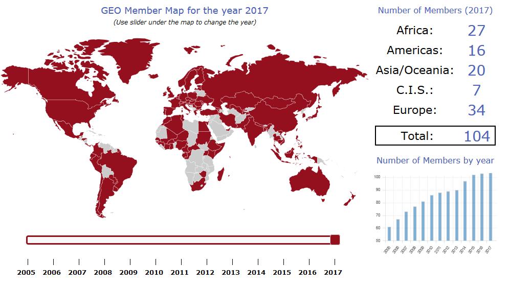
3 The Group on Earth Observation (GEO) GEO is a partnership of more than 100 national governments and in excess of 100 Participating Organizations that envisions a future where decisions and actions for the benefit of humankind are informed by coordinated, comprehensive and sustained Earth observations. Ministers of the GEO member governments meet periodically to provide the political mandate and overall strategic direction for GEO. The Mexico City Ministerial Declaration from the GEO Ministerial Meeting in 2015 saw world leaders commit to support open Earth observation data for the next decade.
4 Participating Member States Organizations
5 Global Earth Observation System of Systems () Together, the GEO community is creating a Global Earth Observation System of Systems (). Earth observations from diverse sources, including satellite, airborne, insitu platforms, and citizen observatories, when integrated together, provide powerful tools for understanding the past and present conditions of Earth systems, as well as the interplay between them. aims to better integrate observing systems and share data by connecting existing infrastructures. There are more than 200 million open data resources in from more than 150 national and regional providers such as NASA and ESA; international organizations such as WMO and the commercial sector such as Digital Globe.
6 Platform (a.k.a. Common Infrastructure - GCI) IMPLEMENTING
 end Users")


7 DOWNSTREAM Application Developers (intermediate Users) end Users Applications Applications Applications MIDSTREAM Platform UPSTREAM Enterprise System 1 Enterprise System 2 System Enterprise 4 System 3. Enterprise System 3 Enterpris e System 1 Enterprise SBA 1 System j SBA 2 System 4. Enterprise System 2 Enterpris e System K. Enterprise System 1 Enterprise System System 3 Enterprise 4 System 2 SBA 8. Enterprise System Z Providers


8 The Platform A collaboration between Co-financed via Grant from DG-RTD Connecting Earth Observation Users x Resource Providers Following a user-centric approach based on three pillars: collaboration, customisation and re-use Coordination with international players via GEO, EC, ESA


9 The Platform Components Data Providers Mirror Societal Benefit Areas Widget > 400 million data resources spanning all SBAs Yellow Pages API Status Checker View


10 Some Platform Numbers Users presently links more than 178 open data catalogs and information systems, comprising over 414 million data and information resources., in the last two years, served about 15 thousand unique users finalizing about 150 thousand searches ~ 150 thousand searches > 178 Data Providers > 45 million Datasets > 400 million Granules 35 Languages Platform including APIs
11 Geolocation of unique IP addresses

12 Academic User Commercial User Governamental User Hosting User Private User Unknown User
13 ADDRESSING HETEROGENEITY
14 GEO DAB OGC CSW AP ISO 1.0 INPE OGC CSW ebrim EO CKAN OGC CSW ebrim CIM ESRI GEOPORTAL 10 OAI PMH 2.0 ESRI GEOPORTAL 10 OpenSearch 1.1 OpenSearch 1.1 ESIP OpenSearch GENESI DR CKAN NetCDF CF 1.4 CUAHSI HIS Central ESRI REST API 10.3 OGC WCS OGC WMS Ecological Markup Language OGC WFS 1.0.0, 1.1.0, OGC WMTS OGC SOS 1.0.0, 2.0.0, Hydro Profile HDF OGC WPS IADC DB (MySQL) OGC CSW Core GrADS DS OGC CSW AP ISO 1.0 FedEO OGC CSW ebrim/eo AP ARPA DB (based on Microsoft SQL) OGC CSW ebrim/cim AP ESRI Map Server IRIS Station SHAPE files (FTP) IRIS Event KISTERS Web Environment of Canada HYRAX THREDDS SERVER 1.9 Environment Canada Hydrometric data (FTP) OAI PMH 2.0 Harvesting OpenSearch 1.1 GBIF Earth Engine DIF RASAQM HYDRO EGASKRO UNAVCO SITAD (Sistema Informativo Territoriale Ambientale Diffuso) CDI 1.04, 1.3, 1.4 File System ISO GDACS THREDDS 1.0.1, GeoRSS 2.0 THREDDS NCISO 1.0.1, Degree catalog service 2.2 THREDDS NCISO PLUS 1.0.1, OpenSearch GENESI DR Introduction of a brokering tier (GEO DAB) DCAT dedicated to mediation of GI cat service interfaces and metadata models harmonization in a transparent NCML OD way for both users and data providers. BCODMO NCML CF The GEO DAB maps the diverse models onto its own internal model, which is general enough to comprise all FTP the populated necessary with supported concepts. metadata types WAF Web Accessible Folders The key features of the GEO DAB internal GeoNetwork data (2.2.0 and or greater) metadata models are flexibility and extensibility allowingnerrs adding (National new Estuarine concepts Research Reserve and System) related HMA CSW ebrim/cim attributes.
 and SAR-type (Sentinel 1) satellite data; Disater Resilience SBA: Earthquake events filters")
15 Portal User-centric, considering various user communities: GEO Flagships and Global initiatives ESA Thematic Exploitation Platforms SBA/Thematic Customization: Satellite: includes smart filters for imagery (Landsat, Sentinel 2) and SAR-type (Sentinel 1) satellite data; Disater Resilience SBA: Earthquake events filters
16 Platform Re-usable Components SUPPORTING USER COMMUNITIES
17 APIs DOWNSTREAM MIDSTREAM end Users A set of standard Web service interfaces: e.g. OGC service interfaces, OAI-PMH, FTP, etc. A set of APIs for software developers: Client side APIs: (high-level) JavaScript library. (Python) Server side APIs: REST/JSON APIs OpenSearch APIs. Applications Applications Applications Application Developers (intermediate Users) Common Infrastructure APIs Mediation modules Portal Advanced users who are experienced in the utilization of geospatial data Web developers with good knowledge of W3C technologies, including: HTML5, Javascript, and CSS Expert users in developing applications which communicate with remote servers over HTTP

 Defined View exposed via the Portal/APIs/Widgets/Mirror Sites Consumer-defined")

18 View Definition: Subset of the whole resources defined by applying, via the DAB, a set of clauses Discovery clauses (e.g. spatial envelope, keywords, sources, etc.) Access clauses (e.g. data format, access protocol, CRS, etc.) Defined View exposed via the Portal/APIs/Widgets/Mirror Sites Consumer-defined View i.e. Client-side These views are available only for the client application which defined the view. Provider-defined View i.e. Server-side These views are available for all client applications.
. This is accomplished by publishing portal code parts (widgets) wrapped up in API Kernel at server side (continue maintenance, enhancements, etc., like a library)")
19 Widget A freely-available instantiation of selected Portal widgets with various functionality made available for possible customization in various areas of application (e.g., a specific SBA, Initiatives, etc.). This is accomplished by publishing portal code parts (widgets) wrapped up in API Kernel at server side (continue maintenance, enhancements, etc., like a library)

20 Mirror Portal site customisation for SBAs, Flagships, Initiatives, Communities It is available at The customisation will better serve the specific community interests by filtering: Catalogues and search results by a specific theme or view (e.g., cold regions, mountains, etc.) Location of interests Services/Processing/Tools (in the future )
21 Thank you
The GEO Discovery and Access Broker
 WGISS-43 The GEO Discovery and Access Broker S. Nativi (1), M. Santoro (1) (1) Institute of Atmospheric Pollution Research, National Research Council of Italy DOWNSTREAM MIDSTREAM end-users Applications
GEOSS Common Infrastructure and the Big Data challenges
 16th Workshop on meteorological operational systems 1-3 March, 2017 GEOSS Common Infrastructure and the Big Data challenges S. Nativi (1), J. Van Bemmelen (2), M. Santoro (1), G. Colangeli (2) O. Ochiai
Multi-disciplinary Interoperability: the EuroGEOSS Operating Capacities
 Multi-disciplinary Interoperability: the EuroGEOSS Operating Capacities Stefano Nativi (CNR) stefano.nativi@cnr.it Opening and context for Global Dimension Stream: EuroGEOSS contribution to the Global
DATA SHARING AND DISCOVERY WITH ARCGIS SERVER GEOPORTAL EXTENSION. Clive Reece, Ph.D. ESRI Geoportal/SDI Solutions Team
 DATA SHARING AND DISCOVERY WITH ARCGIS SERVER GEOPORTAL EXTENSION Clive Reece, Ph.D. ESRI Geoportal/SDI Solutions Team Geoportal Extension for ArcGIS Server Context within an Enterprise Spatial Data Infrastructure
Esri Geoportal Server
 Esri Geoportal Server Implementing a Spatial Data Infrastructure @martenhogeweg Esri Geoportal Server Extending ArcGIS to enable discovery and use of geospatial resources in heterogeneous environments
GENeric European Sustainable Information Space for Environment.
 GENeric European Sustainable Information Space for Environment http://www.genesis-fp7.eu/ Outline Introduction The GENESIS FP7 project The GENESIS solution s architecture GENESIS experience with INSPIRE
SEXTANT 1. Purpose of the Application
 SEXTANT 1. Purpose of the Application Sextant has been used in the domains of Earth Observation and Environment by presenting its browsing and visualization capabilities using a number of link geospatial
Webservice-energy.org GEO Community Portal & Spatial Data Infrastructure for Energy
 Webservice-energy.org GEO Community Portal & Spatial Data Infrastructure for Energy Lionel Menard / Oct. 23 2017 Centre Observation, Impacts, Energy Research activities: Use of Earth observation data (Models,
Multi-disciplinary interoperability challenges
 Seminar at UNIDATA ----- Boulder (CO) USA, 10 Dec 2010 Multi-disciplinary interoperability challenges Stefano Nativi Italian National Research Council and PIN -University of Florence ESSILab Outline System
The GeoPortal Cookbook Tutorial
 The GeoPortal Cookbook Tutorial Wim Hugo SAEON/ SAEOS SCOPE OF DISCUSSION Background and Additional Resources Context and Concepts The Main Components of a GeoPortal Architecture Implementation Options
How to become an INSPIRE node and fully exploit the investments made?
 How to become an INSPIRE node and fully exploit the investments made? Solution patterns for consumers: end users & developers (2/2) Roberto Lucchi 22 June 2010, Krakow 1 Geoportal extension Enabling discovery
Next GEOSS der neue europäische GEOSS Hub
 DLR.de Folie 1 27.10.2016, Oberpfaffenhofen Next GEOSS der neue europäische GEOSS Hub J. Meyer-Arnek, A. Müller, G. Schreier DLR.de Folie 2 NextGEOSS-Konsortium Kick-Off: 16-18 JAN 2017 Project duration:
Metadata for Data Discovery: The NERC Data Catalogue Service. Steve Donegan
 Metadata for Data Discovery: The NERC Data Catalogue Service Steve Donegan Introduction NERC, Science and Data Centres NERC Discovery Metadata The Data Catalogue Service NERC Data Services Case study:
INSPIRE & Environment Data in the EU
 INSPIRE & Environment Data in the EU Andrea Perego Research Data infrastructures for Environmental related Societal Challenges Workshop @ pre-rda P6 Workshops, Paris 22 September 2015 INSPIRE in a nutshell
The geospatial metadata catalogue. FOSS4G Barcelona. Jeroen Ticheler. Founder and chair. Director
 The geospatial metadata catalogue FOSS4G2010 - Barcelona Jeroen Ticheler Director Founder and chair GeoNetwork opensource Dutch National Geo Registry FAO GeoNetwork SwissTopo geocat.ch GeoNetwork history
The EOC Geoservice: Standardized Access to Earth Observation Data Sets and Value Added Products ABSTRACT
 The EOC Geoservice: Standardized Access to Earth Observation Data Sets and Value Added Products K. Dengler, T. Heinen, A. Huber, K. Molch, E. Mikusch German Aerospace Center (DLR) German Remote Sensing
Introduction to Prod-Trees
 European Geosciences Union General Assembly 2014 Prod Trees Bernard Valentin Vienna Austria 29 April 2014 Outline 2 Background Prod-Trees Project RARE Project and Platform Status Future Background (ESA)
Uniform Resource Locator Wide Area Network World Climate Research Programme Coupled Model Intercomparison
 Glossary API Application Programming Interface AR5 IPCC Assessment Report 4 ASCII American Standard Code for Information Interchange BUFR Binary Universal Form for the Representation of meteorological
Initial Operating Capability & The INSPIRE Community Geoportal
 INSPIRE Conference, Rotterdam, 15 19 June 2009 1 Infrastructure for Spatial Information in the European Community Initial Operating Capability & The INSPIRE Community Geoportal EC INSPIRE GEOPORTAL TEAM
Discovery and Access of Geospatial Resources Using GIS Portal Toolkit Marten Hogeweg Product Manager GIS Portal Toolkit
 Discovery and Access of Geospatial Resources Using GIS Portal Toolkit Marten Hogeweg Product Manager GIS Portal Toolkit Outline Elements of Spatial Data Infrastructures Current trends Position of GIS portals
PRODUCT BROCHURE ERDAS APOLLO MANAGING AND SERVING GEOSPATIAL INFORMATION
 PRODUCT BROCHURE ERDAS APOLLO MANAGING AND SERVING GEOSPATIAL INFORMATION ERDAS APOLLO Do you have large volumes of geospatial information, regularly updated data stores, and a distributed user base? Do
ERDAS APOLLO Managing and Serving Geospatial Information
 ERDAS APOLLO Managing and Serving Geospatial Information ERDAS APOLLO Do you have large volumes of geospatial information, regularly updated data stores, and a distributed user base? Do you need a single,
Achieving Interoperability using the ArcGIS Platform. Satish Sankaran Roberto Lucchi
 Achieving Interoperability using the ArcGIS Platform Satish Sankaran Roberto Lucchi Thank you Please fill out the session survey in your mobile app Select [Achieving Interoperability using the ArcGIS Platform]
Increasing dataset quality metadata presence: Quality focused metadata editor and catalogue queriables.
 Increasing dataset quality metadata presence: Quality focused metadata editor and catalogue queriables. Alaitz Zabala (UAB), Joan Masó (CREAF), Lucy Bastin (ASTON), Fabrizio Papeschi (CNR), Eva Sevillano
Standards and business models transformations
 Standards and business models transformations Inspire Conference 2017 by Jean Michel Zigna, with support of Elisabeth Lambert, Tarek Habib, Tony Jolibois and Sylvain Marty Collecte Localisation Satellite
Leveraging OGC Services in ArcGIS Server. Satish Sankaran, Esri Yingqi Tang, Esri
 Leveraging OGC Services in ArcGIS Server Satish Sankaran, Esri Yingqi Tang, Esri GIS Creating and Managing Geo Information Products - Proprietary - Open Specifications - Standards Dissemination of Geo
SMARTERDECISIONS. Geospatial Portal 2013 Open Interoperable GIS/Imagery Services with ERDAS Apollo 2013 and ERDAS Imagine 2013
 Geospatial Portal 2013 Open Interoperable GIS/Imagery Services with ERDAS Apollo 2013 and ERDAS Imagine 2013 Carahsoft Intergraph Government Solutions SMARTERDECISIONS Geospatial Portal 2013 Geospatial
(Geo)DCAT-AP Status, Usage, Implementation Guidelines, Extensions
DCAT-AP Status, Usage, Implementation Guidelines, Extensions") (Geo)DCAT-AP Status, Usage, Implementation Guidelines, Extensions HMA-AWG Meeting ESRIN (Room D) 20. May 2016 Uwe Voges (con terra GmbH) GeoDCAT-AP European Data Portal European Data Portal (EDP): central
(Geo)DCAT-AP Status, Usage, Implementation Guidelines, Extensions HMA-AWG Meeting ESRIN (Room D) 20. May 2016 Uwe Voges (con terra GmbH) GeoDCAT-AP European Data Portal European Data Portal (EDP): central
Catalog-driven, Reproducible Workflows for Ocean Science
 Catalog-driven, Reproducible Workflows for Ocean Science Rich Signell, USGS, Woods Hole, MA, USA Filipe Fernandes, Centro Universidade Monte Serrat, Santos, Brazil. 2015 Boston Light Swim, Aug 15, 7:00am
IMAGERY FOR ARCGIS. Manage and Understand Your Imagery. Credit: Image courtesy of DigitalGlobe
 IMAGERY FOR ARCGIS Manage and Understand Your Imagery Credit: Image courtesy of DigitalGlobe 2 ARCGIS IS AN IMAGERY PLATFORM Empowering you to make informed decisions from imagery and remotely sensed data
The Common Framework for Earth Observation Data. US Group on Earth Observations Data Management Working Group
 The Common Framework for Earth Observation Data US Group on Earth Observations Data Management Working Group Agenda USGEO and BEDI background Concise summary of recommended CFEOD standards today Full document
Esri Support for Geospatial Standards
 APRIL 2017 ArcGIS Is Open and Interoperable Esri Support for Geospatial Standards Copyright 2017 Esri All rights reserved. Printed in the United States of America. The information contained in this document
Call for Participation in AIP-6
 Call for Participation in AIP-6 GEOSS Architecture Implementation Pilot (AIP) Issue Date of CFP: 9 February 2013 Due Date for CFP Responses: 15 March 2013 Introduction GEOSS Architecture Implementation
Data discovery and access via the SeaDataNet CDI system
 Data discovery and access via the SeaDataNet CDI system Central dataproducts and data services on distributed data. Peter Thijsse MARIS CLIPC IS-ENES workshop, KNMI, November 2014 Outline 1. Introduction
INSPIRE: The ESRI Vision. Tina Hahn, GIS Consultant, ESRI(UK) Miguel Paredes, GIS Consultant, ESRI(UK)
 Miguel Paredes, GIS Consultant, ESRI(UK)") INSPIRE: The ESRI Vision Tina Hahn, GIS Consultant, ESRI(UK) Miguel Paredes, GIS Consultant, ESRI(UK) Overview Who are we? Introduction to ESRI Inc. and ESRI(UK) Presenters ArcGIS The ESRI Solution to
INSPIRE: The ESRI Vision Tina Hahn, GIS Consultant, ESRI(UK) Miguel Paredes, GIS Consultant, ESRI(UK) Overview Who are we? Introduction to ESRI Inc. and ESRI(UK) Presenters ArcGIS The ESRI Solution to
GEOSS Common Infrastructure (GCI) Research Engineering Report GEO Architecture Implementation Pilot, Phase 5 GEOSS Architecture Implementation Pilot
 Research Engineering Report GEO Architecture Implementation Pilot, Phase 5 GEOSS Architecture Implementation Pilot") GEOSS Common Infrastructure (GCI) Research Engineering Report GEO Architecture Implementation Pilot, Phase 5 GEOSS Architecture Implementation Pilot Version 1.1 Content developed by the GEO Architecture
GEOSS Common Infrastructure (GCI) Research Engineering Report GEO Architecture Implementation Pilot, Phase 5 GEOSS Architecture Implementation Pilot Version 1.1 Content developed by the GEO Architecture
Leveraging OGC Standards on ArcGIS Server
 Leveraging OGC Standards on ArcGIS Server Satish Sankaran Interoperability and Standards Team James Michel III ESRI Intel Team ArcGIS Server Complete Interoperable Server-Based GIS Desktop Explorer Web
Introduction to INSPIRE. Network Services
 Introduction to INSPIRE. Network Services European Commission Joint Research Centre Institute for Environment and Sustainability Digital Earth and Reference Data Unit www.jrc.ec.europa.eu Serving society
The Many Facets of THREDDS Thematic Real-time Environmental Distributed Data Services
 The Many Facets of THREDDS Thematic Real-time Environmental Distributed Data Services For March 2007 Unidata Policy Committee Meeting Ben Domenico 1 Motivation From the Unidata 2003 proposal: utilizing
EarthLookCZ as Czech way to GMES
 EarthLookCZ as Czech way to GMES Karel Charvat 1 and Petr Horak 1 1 WirelessInfo, Czech Republic, charvat@wirelessinfo.cz Abstract Global Monitoring for Environment and Security is one of 4 ranges of solutions
Spatial Data on the Web
 Spatial Data on the Web Tools and guidance for data providers The European Commission s science and knowledge service W3C Data on the Web Best Practices 35 W3C/OGC Spatial Data on the Web Best Practices
GeoDCAT-AP Representing geographic metadata by using the "DCAT application profile for data portals in Europe"
 GeoDCAT-AP Representing geographic metadata by using the "DCAT application profile for data portals in Europe" Andrea Perego, Vlado Cetl, Anders Friis-Christensen, Michael Lutz, Lorena Hernandez Joint
Outline. The Collaborative Research Platform for Data Curation and Repositories: CKAN For ANGIS Data Portal. Open Access & Open Data.
 Outline The Collaborative Research Platform for Data Curation and Repositories: CKAN For ANGIS Data Portal Open Access & Open Data ANGIS data portal New developed features Future works Hsiung-Ming Liao,
The European Commission s science and knowledge service. Joint Research Centre
 The European Commission s science and knowledge service Joint Research Centre GeoDCAT-AP The story so far Andrea Perego, Antonio Rotundo, Lieven Raes GeoDCAT-AP Webinar 6 June 2018 What is GeoDCAT-AP Geospatial
SAFER the GIGAS Effect
 SAFER the GIGAS Effect How INSPIRE, GMES and GEOSS are influencing EC projects Arnaud Cauchy 23/06/2010 Agenda GIGAS Project Summary SAFER Project Summary SAFER Original Approach GIGAS Influences SAFER
INSPIRE and Open Data Recent Developments and Best Practices
 INSPIRE and Open Data Recent Developments and Best Practices These documents are only complete, when used in connection with the verbal paper; any isolated use may lead to misunderstandings. Michael Müller
MY DEWETRA IPAFLOODS REPORT
 Grant Contract N. ECHO/SUB/2014/692292 Programme for Prevention, Preparedness and Response to Floods in the Western Balkans and Turkey IPA FLOODS Capacity Building Activities 2016 MY DEWETRA IPAFLOODS
Leveraging metadata standards in ArcGIS to support Interoperability. Aleta Vienneau and Marten Hogeweg
 Leveraging metadata standards in ArcGIS to support Interoperability Aleta Vienneau and Marten Hogeweg Leveraging metadata standards in ArcGIS to support Interoperability Overview of metadata standards
Addressing Geospatial Big Data Management and Distribution Challenges ERDAS APOLLO & ECW
 Addressing Geospatial Big Data Management and Distribution Challenges ERDAS APOLLO & ECW Nouman Ahmed GeoSystems-Me (Hexagon Geospatial / ERDAS Regional Partner) Enterprise Solutions Architect Hexagon
SDI SOLUTIONS FOR INSPIRE: TECHNOLOGIES SUPPORTING A FRAMEWORK OF COOPERATION
 SDI SOLUTIONS FOR INSPIRE: TECHNOLOGIES SUPPORTING A FRAMEWORK OF COOPERATION Roberto Lucchi 1, Marten Hogeweg 1, Guenther Pichler 2 1 Esri, Redlands, CA, USA 2 Esri Kranzberg, Germany 1 Vision INSPIRE
International Organization for Standardization Technical Committee 211 (ISO/TC211)
") Esri Support for Geospatial Standards: Open Geospatial Consortium (OGC) International Organization for Standardization Technical Committee 211 (ISO/TC211) An Esri White Paper April 2015 Copyright 2015
Esri Support for Geospatial Standards: Open Geospatial Consortium (OGC) International Organization for Standardization Technical Committee 211 (ISO/TC211) An Esri White Paper April 2015 Copyright 2015
Providing Interoperability Using the Open GeoServices REST Specification
 2013 Esri International User Conference July 8 12, 2013 San Diego, California Technical Workshop Providing Interoperability Using the Open GeoServices REST Specification Satish Sankaran Kevin Sigwart What
/// INTEROPERABILITY BETWEEN METADATA STANDARDS: A REFERENCE IMPLEMENTATION FOR METADATA CATALOGUES
 /// Position Paper /// INTEROPERABILITY BETWEEN METADATA STANDARDS: A REFERENCE IMPLEMENTATION FOR METADATA CATALOGUES /// Keywords: Public administration, Metadata, Geographical Information, Geospatial
Long-term preservation for INSPIRE: a metadata framework and geo-portal implementation
 Long-term preservation for INSPIRE: a metadata framework and geo-portal implementation INSPIRE 2010, KRAKOW Dr. Arif Shaon, Dr. Andrew Woolf (e-science, Science and Technology Facilities Council, UK) 3
Citizens Science and Smart Cities JRC Ispra 5-7 February The Brokering Approach
 Citizens Science and Smart Cities JRC Ispra 5-7 February 2014 The Brokering Approach STEFANO NATIVI (CNR -IIA), MAX CRAGLIA (EC-JRC) AND MAT TIA SANTORO (CNR-IIA) Rationale Build «Network of Networks»
Interoperability with ArcGIS
 Interoperability with ArcGIS Satish Sankaran Marten Hogeweg Agenda Understanding Interoperability What, Why and How? ArcGIS Platform An Open Platform Supporting Interoperability Examples from the real
GEO Update and Priorities for 2014
 GEO Update and Priorities for 2014 Osamu Ochiai GEO Secretariat 37 th CEOS WGCV Plenary Frascati, 17-20 Feb 2014 GEO Secretariat Ministerial Summit, Geneva Jan 17 th 2014 Highest number of participants
OpenData and INSPIRE with GeoServer, GeoNetwork and MapStore: lessons learned from real-world use cases
 OpenData and INSPIRE with GeoServer, GeoNetwork and MapStore: lessons learned from real-world use cases Ing. Simone Giannecchini, GeoSolutions Silvana Griffa, CSI Piemonte Giovanni Menduni, City of Florence
Making Open Data work for Europe
 Making Open Data work for Europe Daniele Rizzi European Commission DG Communications Networks, Content and Technology daniele.rizzi@ec.europa.eu Nikolaos Loutas PwC EU Services nikolaos.loutas@be.pwc.com
Implementing a Data Quality Strategy to simplify access to data
 IN43D-07 AGU Fall Meeting 2016 Implementing a Quality Strategy to simplify access to data Kelsey Druken, Claire Trenham, Ben Evans, Clare Richards, Jingbo Wang, & Lesley Wyborn National Computational Infrastructure,
CWIC Data Partner s Guide (OpenSearch) Approval Date:
 Approval Date:") CEOS CWIC Project CWIC Data Partner s Guide (OpenSearch) Approval Date: 2017-05-09 Publication Date: 2017-05-10 Reference number of this Document: CWIC-DOC-14-001r010 Document version: V1.0 Category: CWIC
CEOS CWIC Project CWIC Data Partner s Guide (OpenSearch) Approval Date: 2017-05-09 Publication Date: 2017-05-10 Reference number of this Document: CWIC-DOC-14-001r010 Document version: V1.0 Category: CWIC
Leveraging OGC Services in ArcGIS Server. Satish Sankaran Yingqi Tang
 Leveraging OGC Services in ArcGIS Server Satish Sankaran ssankaran@esri.com Yingqi Tang ytang@esri.com Agenda Interoperability Enablers OGC and esri OGC Web Services ArcGIS and OGC Web Services - @ version
Jeffery S. Horsburgh. Utah Water Research Laboratory Utah State University
 Advancing a Services Oriented Architecture for Sharing Hydrologic Data Jeffery S. Horsburgh Utah Water Research Laboratory Utah State University D.G. Tarboton, D.R. Maidment, I. Zaslavsky, D.P. Ames, J.L.
GSCB-Workshop on Ground Segment Evolution Strategy
 GSCB-Workshop on Ground Segment Evolution Strategy N. Hanowski, EOP-G, Ground Segment and Operations Department, nicolaus.hanowski@esa.int 24 September 2015 ESA UNCLASSIFIED For Official Use - Slide 1
Interoperability and Standards Supports in ArcGIS
 Esri International User Conference San Diego, California Technical Workshops July 26, 2012 Interoperability and Standards Supports in ArcGIS Satish Sankaran, Esri Yingqi Tang, Esri Agenda Esri s participation
EVOlution of EO Online Data Access Services (EVO-ODAS) ESA GSTP-6 Project by DLR, EOX and GeoSolutions (2015/ /04)
 ESA GSTP-6 Project by DLR, EOX and GeoSolutions (2015/ /04)") EVOlution of EO Online Data Access Services (EVO-ODAS) ESA GSTP-6 Project by DLR, EOX and GeoSolutions (2015/10 2017/04) 2016 Conference on Big Data from Space - BiDS 16, Tenerife, 15 th -17 th March Evolution
EVOlution of EO Online Data Access Services (EVO-ODAS) ESA GSTP-6 Project by DLR, EOX and GeoSolutions (2015/10 2017/04) 2016 Conference on Big Data from Space - BiDS 16, Tenerife, 15 th -17 th March Evolution
Leveraging metadata standards in ArcGIS to support Interoperability. David Danko and Aleta Vienneau
 Leveraging metadata standards in ArcGIS to support Interoperability David Danko and Aleta Vienneau Leveraging Metadata Standards in ArcGIS for Interoperability Why metadata and metadata standards? Overview
Integrating the UK Location Information Infrastructure and data.gov.uk
 Integrating the UK Location Information Infrastructure and data.gov.uk Rod Kedge - UK Location Programme 1 July 20011 This presentation The issue: How to derive the benefits of INSPIRE Background UKLII
The NextGEOSS Project
 NextGEOSS GEOSS Interoperability workshop 28 August 2017 The NextGEOSS Project Marie-Francoise Voidrot, Bart De Lathouwer Open Geospatial Consortium Europe Nuno Catarino DEIMOS Head of Data Systems NextGEOSS
Ocean, Atmosphere & Climate Model Assessment for Everyone
 Ocean, Atmosphere & Climate Model Assessment for Everyone Rich Signell USGS Woods Hole, MA Unidata 2014 DeSouza Award Presentation Boulder, CO : Sep 15, 2014 2 US Integrated Ocean Observing System (IOOS
From Geoportal to Spatial Data Service Platform. Jani Kylmäaho National Land Survey of Finland Development Centre
 From Geoportal to Spatial Data Service Platform Jani Kylmäaho National Land Survey of Finland Development Centre Introduction National Land Survey of Finland - 1900 employees Development Centre - 120 employees
Achieving Interoperability Using Open Standards
 FedGIS Conference February 24 25, 2016 Washington, DC Achieving Interoperability Using Open Standards Satish Sankaran Marten Hogeweg Agenda Understanding Interoperability What, Why and How? ArcGIS Platform
Standards-based Access to Satellite Atmospheric Composition Data
 www.dlr.de Chart 1 Working Group on Information Systems and Services Standards-based Access to Satellite Atmospheric Composition Data S. Falke, C. Lynnes, J. Meyer-Arnek, O. Goussev, M. Bittner et al.
Relation between Geospatial information projects related to GBIF
 Relation between Geospatial information projects related to GBIF Synthesys 3.6-Synthesys 3.7-GBIF.DE- BioGeomancer The most up to date work can always be found at: http://www.biogeografia.com/synthesys
European Space Policy
 European Space Policy Eleni Paliouras, ESA EuroGeographics General Assembly 3 October 2017 Vienna, Austria ESA UNCLASSIFIED - For Official Use ESA facts and figures Intergovernmental agency of 22 Member
Compass INSPIRE Services. Compass INSPIRE Services. White Paper Compass Informatics Limited Block 8, Blackrock Business
 Compass INSPIRE Services White Paper 2010 Compass INSPIRE Services Compass Informatics Limited Block 8, Blackrock Business Park, Carysfort Avenue, Blackrock, County Dublin, Ireland Contact Us: +353 1 2104580
Developing data catalogue extensions for metadata harvesting in GIS
 University of Bergen Department of Informatics Developing data catalogue extensions for metadata harvesting in GIS Author: André Mossige Long master thesis June 2018 Acknowledgements I would like to thank
Experience federating the metadata catalogue of IGN in the Spanish Open Data Portal
 Experience federating the metadata catalogue of IGN in the Spanish Open Data Portal Paloma Abad E. López, A.F. Rodríguez, A. Sánchez, S. Castro, S. Soriano, J.I Sánchez 1 Summary IGN Metadata Catalogue
Air Quality Community Scenario Engineering Report GEOSS Architecture Implementation Pilot, Phase 2 Version <1.4>
 Air Quality Community Scenario Engineering Report GEOSS Architecture Implementation Pilot, Phase 2 Version Content developed by the GEO Architecture Implementation Pilot Licensed under a Creative
Esri Support for Geospatial Standards: OGC and ISO/TC211. An Esri White Paper May 2015
 Esri Support for Geospatial Standards: OGC and ISO/TC211 An Esri White Paper May 2015 Copyright 2015 Esri All rights reserved. Printed in the United States of America. The information contained in this
Database Web Portal Version 1
 Database Web Portal Version 1 Deliverable D6.5 Issue 0.2 Due date of deliverable: 01 Dec 2014 Actual submission date: 05 Dec 2014 SEN3APP Processing Lines And Operational Services Combining Sentinel And
SmartHMA Introduction of SmartHMA project objectives
 SmartHMA Introduction of SmartHMA project objectives Daniel Zinkiewicz (daniel.zinkiewicz@wasat.pl) Wasat Sp. z o.o. Slide 1 SmartHMA SmartHMA SmartHMA mobile platform for deployment of HMA standardised
Linking and Finding Earth Observation (EO) Data on the Web
 Data on the Web") Linking and Finding Earth Observation (EO) Data on the Web MACS-G20 Workshop: Linked Open Data in Agriculture Berlin, September 27-28, 2017 Dr. Uwe Voges u.voges@conterra.de Introduction Earth Observation
Linking and Finding Earth Observation (EO) Data on the Web MACS-G20 Workshop: Linked Open Data in Agriculture Berlin, September 27-28, 2017 Dr. Uwe Voges u.voges@conterra.de Introduction Earth Observation
SPACE for SDGs a Global Partnership
 SPACE for SDGs a Global Partnership for the Coordination of the Development, Operation and Utilization of Space related Infrastructure, Data, Information and Services in support of the 2030 Development
Big Data Earth Observation Standardization elements Codrina Ilie TERRASIGNA TF7/SG5
 Big Data Earth Observation Standardization elements Codrina Ilie TERRASIGNA TF7/SG5 1 Earth Observation standardization intro 2 directions: 1. standardization of the Ground Segment Services: Heterogeneous
WGISS Report and Actions
 WGISS Report and Actions Pakorn Apaphant, GISTDA Chair Satoko Miura, JAXA Vice Chair Item16.1 October 14, 2010 The 24 th CEOS Plenary Rio de Janeiro, Brazil 12-15 October, 2010 1 2010 WGISS Themes o Focus
Download Service Implementing Rule and Technical Guidance
 Download and Transformation Draft Implementing Rules Presentation for INSPIRE Initiatives Download Service Implementing Rule and Technical Guidance Olaf Østensen Statens kartverk Norwegian Mapping Authority
natural disasters: the role of the Group
 Earth observations for the mitigation of natural disasters: the role of the Group on Earth Observations Francesco GAETANI GEO Secretariat DRAFT Created in 2005, to develop a coordinated and sustained Global
Harvard Hypermap: An Open Source Framework for Making the World's Geospatial Information more Accessible
 American Association of Geographers Boston, Massachusetts April, 2017 Harvard Hypermap: An Open Source Framework for Making the World's Geospatial Information more Accessible Benjamin Lewis, Paolo Corti,
Monitoring the Environment for Climate Change: The case of GMES
 Monitoring the Environment for Climate Change: The case of GMES Presentation at 2008 IISL ECSL Symposium Legal Implications of Space Applications for Climate Change: Principles and Rules Dr. jur.gisela
Greece s Collaborative Ground Segment Initiatives
 Greece s Collaborative Ground Segment Initiatives Dr Haris KONTOES National Observatory of Athens SENTINEL COLLABORATIVE GS WORKSHOP 2015, 28 May 2015 Matera Collaborative GS workshop 2015 27 28 May 2015
Implementing a Data Quality Strategy to simplify access to data
 Implementing a Quality Strategy to simplify access to data Kelsey Druken Implementing a Quality Strategy to simplify access to data Kelsey Druken, Claire Trenham, Lesley Wyborn, Ben Evans National Computational
PortalU, a Tool to Support the Implementation of the Shared Environmental Information System (SEIS) in Germany
 in Germany") European conference of the Czech Presidency of the Council of the EU TOWARDS eenvironment Opportunities of SEIS and SISE: Integrating Environmental Knowledge in Europe http:/www.e-envi2009.org/proceedings/
European conference of the Czech Presidency of the Council of the EU TOWARDS eenvironment Opportunities of SEIS and SISE: Integrating Environmental Knowledge in Europe http:/www.e-envi2009.org/proceedings/
The NCAR Community Data Portal
 The NCAR Community Data Portal http://cdp.ucar.edu/ QuickTime and a TIFF (Uncompressed) decompressor are needed to see this picture. QuickTime and a TIFF (Uncompressed) decompressor are needed to see this
GeoDCAT-AP: Use cases and open issues
 Authors Affiliation Andrea Perego, Anders Friis-Christensen, Michael Lutz European Commission, Joint Research Centre (JRC) (https://ec.europa.eu/jrc/) This paper illustrates some issues and use cases identified
HDF Product Designer: A tool for building HDF5 containers with granule metadata
 The HDF Group HDF Product Designer: A tool for building HDF5 containers with granule metadata Lindsay Powers Aleksandar Jelenak, Joe Lee, Ted Habermann The HDF Group Data Producer s Conundrum 2 HDF Features
FP7-INFRASTRUCTURES Grant Agreement no Scoping Study for a pan-european Geological Data Infrastructure D 4.4
 FP7-INFRASTRUCTURES-2012-1 Grant Agreement no. 312845 Scoping Study for a pan-european Geological Data Infrastructure D 4.4 Report on recommendations for implementation of the EGDI Deliverable number D4.4
ESRI & Interoperability. David Danko ISO TC 211 Metadata Project Leader OGC Metadata WG Chair ESRI Senior Consultant GIS Standards
 ESRI & Interoperability David Danko ISO TC 211 Metadata Project Leader OGC Metadata WG Chair ESRI Senior Consultant GIS Standards ddanko@esri.com GIS has always required Interoperability Social Factors
SHARING GEOGRAPHIC INFORMATION ON THE INTERNET ICIMOD S METADATA/DATA SERVER SYSTEM USING ARCIMS
 SHARING GEOGRAPHIC INFORMATION ON THE INTERNET ICIMOD S METADATA/DATA SERVER SYSTEM USING ARCIMS Sushil Pandey* Birendra Bajracharya** *International Centre for Integrated Mountain Development (ICIMOD)
EXTRA Examples of OGC standards in support of health applications
 EXTRA Examples of OGC standards in support of health applications Some prior / existing initiatives using OGC Standards EU INSPIRE (health and safety working group) GEOSS AIP, EO2Heaven project: EO2HEAVEN