GEOSS Common Infrastructure and the Big Data challenges
|
|
|
- Priscilla Ray
- 5 years ago
- Views:
Transcription
, G. Colangeli (2) O. Ochiai (3), P.")
1 16th Workshop on meteorological operational systems 1-3 March, 2017 GEOSS Common Infrastructure and the Big Data challenges S. Nativi (1), J. Van Bemmelen (2), M. Santoro (1), G. Colangeli (2) O. Ochiai (3), P. De Salvo (3) (1) Institute of Atmospheric Pollution Research, National Research Council of Italy (2) European Space Agency (3) GEO Secretariat
2 Group on Earth Observation and Global Earth Observation system of systems GEO AND GEOSS

3 The Group on Earth Observation (GEO) GEO is a partnership of more than 100 national governments and in excess of 100 Participating Organizations that envisions a future where decisions and actions for the benefit of humankind are informed by coordinated, comprehensive and sustained Earth observations. Ministers of the GEO member governments meet periodically to provide the political mandate and overall strategic direction for GEO. GEO The Mexico is acity unique Ministerial global Declaration networkfrom connecting the GEO Ministerial government institutions, Meeting 2015 academic saw world andleaders research commit institutions, to support data open providers, Earth businesses, observation data engineers, for the scientists next decade. and experts to create innovative solutions to global challenges at a time of exponential data growth, human development and climate change that transcend national and disciplinary boundaries. The unprecedented global collaboration of experts helps identify gaps and reduce duplication in the areas of sustainable development and sound environmental management.

4 104 Member States

5 106 Participating Organizations
6 Global Earth Observation System of Systems (GEOSS) Together, the GEO community is creating a Global Earth Observation System of Systems (GEOSS). Earth observations from diverse sources, including satellite, airborne, in-situ platforms, and citizen observatories, when integrated together, provide powerful tools for understanding the past and present conditions of Earth systems, as well as the interplay between them. GEOSS aims to better integrate observing systems and share data by connecting existing infrastructures. There are more than 200 million open data resources in GEOSS from more than 150 national and regional providers such as NASA and ESA; international organizations such as WMO and the commercial sector such as Digital Globe.

7 GEOSS Societal Benefit Areas
8 GEOSS Common Infrastructure (GCI) IMPLEMENTING GEOSS


9 DOWNSTREAM MIDSTREAM GEOSS end-users GEOSS GEOSS Applications GEOSS GEOSS Applications Applications GEOSS Application Developers (intermediate Users) GEOSS Common Infrastructure APIs Mediation modules GEOSS Portal UPSTREAM Enterprise System 1 Enterprise System 2 System Enterprise 4 System 3. Enterprise System 3 Enterpris e System 1 Enterprise SBA 1 System j SBA 2 System 4. Enterprise System 2 Enterpris e System K. Enterprise System 1 System 4 Enterprise System 2 SBA 8. Enterprise System 3 Enterprise System Z GEOSS Providers

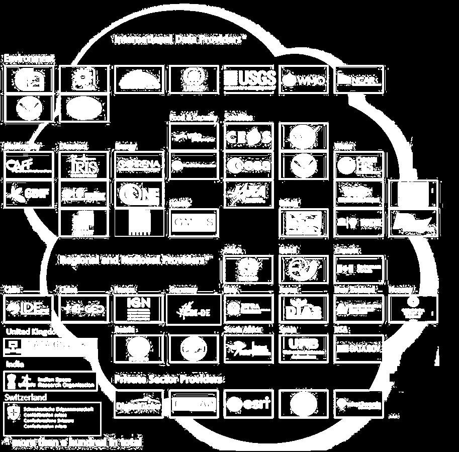


10 GEOSS Common Infrastructure (GCI) Societal Benefit Areas Data Providers GCI Registration M2M > 200 million data resources spanning all SBAs

11 Enhanced GEOSS Portal - Overview Enhanced during 2016 Accessible from Coordinated with ESA, CNR-IIA, DG-RTD, DG-JRC and GeoSec Focus on engagement, delivery and advocating Structured in 3 phases 1 st phase 2016: interface restyling: completed 2 nd phase 2017/18: deployment of major upgrades 3 rd phase 2019 onwards operations and evolutions
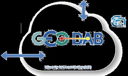
12 GEO Discovery and Access Broker (DAB) GEO DAB is a brokering framework that interconnects hundreds of heterogeneous and autonomous supply systems (the enterprise systems constituting the GEO metasystem) by providing mediation, harmonization and transformation capabilities.
13 BIG DATA IN GEOSS
14 Big Data Enabling Technologies Computing Storage Monitoring Auto Scaling Load Balancing Routing NoSQL Database Clustering
15 Big Data challenges for the GCI VARIETY


16 Variety in GEOSS Variety is the most important V for GEOSS. More than 155 Brokered Systems About 200 M granules

17 OGC CSW AP ISO 1.0 INPE OGC CSW ebrim EO OGC CSW ebrim CIM ESRI GEOPORTAL 10 GI-cat OAI-PMH 2.0 ESRI GEOPORTAL 10 OpenSearch 1.1 NCML-OD OpenSearch 1.1 ESIP BCODMO OpenSearch GENESI DR CKAN NetCDF-CF 1.4 CKAN DCAT Adopted Solutions GEO DAB NCML-CF Introduction of a brokering tier (GEO DAB) dedicated FTP populated with supported metadata types to mediation of service interfaces and WAF Web Accessible Folders GeoNetwork (2.2.0 or greater) models harmonization in a transparent way for both NERRS (National Estuarine Research Reserve System) users and data providers. CUAHSI HIS-Central ESRI REST API 10.3 OGC WCS OGC WMS Ecological Markup Language OGC WFS 1.0.0, 1.1.0, OGC WMTS HMA CSW ebrim/cim OGC SOS 1.0.0, 2.0.0, Hydro Profile HDF OGC WPS OGC CSW Core OGC CSW AP ISO 1.0 OGC CSW ebrim/eo AP OGC CSW ebrim/cim AP IRIS Station SHAPE files (FTP) IRIS Event KISTERS Web - Environment of Canada HYRAX THREDDS SERVER 1.9 OAI-PMH Harvesting OpenSearch 1.1 GBIF DIF HYDRO UNAVCO SITAD (Sistema Informativo Territoriale Ambientale Diffuso) CDI 1.04, 1.3, 1.4 File System ISO GDACS THREDDS 1.0.1, GeoRSS 2.0 THREDDS-NCISO 1.0.1, Degree catalog service 2.2 THREDDS-NCISO-PLUS 1.0.1, OpenSearch GENESI DR The GEO DAB maps the diverse IADC DB (MySQL) models onto its own GrADS-DS FedEO internal model, which is general enough to comprise ARPA DB (based on Microsoft SQL) ESRI Map Server all the necessary concepts. The key features of the GEO Environment DAB Canada Hydrometric internal data (FTP) data and Earth Engine metadata models are flexibility and extensibility RASAQM EGASKRO allowing adding new concepts and related attributes.


 satellite data; Disater Resilience SBA:")
18 Adopted Solutions GEOSS Portal User-centric, considering various user communities: GEO Flagships and Global initiatives ESA Thematic Exploitation Platforms SBA/Thematic Customization: Satellite: includes smart filters for imagery (Landsat, Sentinel 2) and SAR-type (Sentinel 1) satellite data; Disater Resilience SBA: Earthquake events filters
19 Big Data challenges for the GCI VOLUME
20 Volume in GEOSS GEOSS has to deal with the large amount of datasets provided by the end systems, e.g. millions of discoverable (small to medium size) products, and long EO time/space series. While GEOSS does not store the datasets, it has to collect metadata (at least for harvested catalogs) and provide effective discoverability.

21 Adopted Solutions Dealing with such numbers, normally constrained queries commonly match a large number of datasets. GCI addresses this challenge by returning a smaller and/or an ordered result sets. Ranking and Paging Views


22 Ranking and Paging No-SQL DB Good performances on large stores No preliminary constraint on data structure Need to preliminarily index queryable elements GEO DAB Internal Metadata Model Pre-calculated in batch, based on: Metadata Quality Accessibility Etc. Calculated on-the-fly, based on: Query Constraints Applied to scores (configurable)
 Access clauses (e.g. data format, access protocol, CRS, etc.")

23 GEOSS View Definition: Subset of the whole GEOSS resources defined by applying, via the DAB, a set of clauses Discovery clauses (e.g. spatial envelope, keywords, sources, etc.) Access clauses (e.g. data format, access protocol, CRS, etc.) Defined View exposed on the GEOSS Portal Consumer-defined View i.e. Client-side These views are available only for the client application which defined the view. Provider-defined View i.e. Server-side These views are available for all client applications.
24 Big Data challenges for the GCI VELOCITY
25 Velocity in GEOSS In GEOSS, Velocity related challenges include: Processing rate to transform and preview data Asynchronous approach for data access Real-time (or near real-time) data access
26 Adopted Solutions Fast Preview GEO DAB provides a fast preview service allowing to get data preview: Metadata record is augmented by adding a reference to data preview; preview tiles at different zoom levels are generated in a batch mode. To store and retrieve single tiles in an efficient way, GEO DAB utilizes a NoSQL key-value DB. When available, GEO DAB utilizes data provider fast prview services by implementing the required mediation. GEOSS Portal uses allows Users to quickly evaluate discovered data before deciding the download.
27 Adopted Solutions Asyncronous Approach In an environment such as GEOSS, no matter which technique is implemented there will always be cases in which the required processing is consuming too much time for a click-and-get pattern. The DAB + GEOSS Portal access transformation allows to deliver discovered datasets according to a common grid: format, Coordinate Reference System, spatial and temporal extent and resolution. Where this transformation workflow requires a long processing time, Users are allowed to opt for an asynchronous version of the same services.

28 Adopted Solutions Real-time (or near realtime) GEOSS must support near real-time data discovery and access (i.e. GEOSS must be able to broker near real-time systems) Two strategies have been pursued to broker these systems: Distribute GEOSS Users' queries to the near real-time systems, on-the-fly: Provides Users with the most updated content Lower performance Non-consistent ranking Harvest information of near real-time systems at regular and effective intervals: Global Biodiversity Facility (GBIF) INPE Steallite Imagery ESRI ArcGIS Online Does not provide Users with the most updated content... Good performance Consistent ranking
29 Big Data challenges for the GCI VISUALIZATION
30 Visualization in GEOSS In GEOSS, challenges related to Visualization stem from datasets heterogeneity and volume. In addition, GEOSS needs to address the requirement to support diverse (cross-)disciplinary applications targeting different Communities and User categories which have different needs, as for data visualization in an informative and significant way.
31 Adopted solutions GEOSS Portal customization: In addition to what was described in Variety challenge, GEOSS Portal is focusing on providing resuable Portlets (for integration in external Community Applications) and custom visualization of results (e.g. display seismic events according to magnitude) A set of high-level APIs (Application Program Interfaces) have been designed and developed along with documentation and usage examples (the GEO DAB APIs) to allow the development of ad-hoc applications exploiting GEOSS content.
 A set of standard Web service interfaces: e.g. OGC service interfaces, CKAN, OAI-PMH, FTP, etc.")
 Server side APIs: Enterprise SBA 1 System j SBA 2 REST/JSON APIs OpenSearch APIs. 4 Enterprise System 3 Enterpris e System System 4 Enterprise System 2 Enterpris e System K.")
32 DOWNSTREAM MIDSTREAM GEOSS end-users GEOSS GEOSS Applications GEOSS GEOSS Applications Applications GEOSS Application Developers (intermediate Users) GEOSS Common Infrastructure APIs Mediation modules GEOSS Portal Different APIs for serving diverse Application development use cases (environments) A set of standard Web service interfaces: e.g. OGC service interfaces, CKAN, OAI-PMH, FTP, etc. Enterprise System 1 A set of APIs for software Enterprise developers: System 2 System Client side Enterprise APIs: UPSTREAM System 3 (high-level). JavaScript library 1.. (Python) Server side APIs: Enterprise SBA 1 System j SBA 2 REST/JSON APIs OpenSearch APIs. 4 Enterprise System 3 Enterpris e System System 4 Enterprise System 2 Enterpris e System K. Enterprise System 1 Enterprise System System 3 Enterprise 4 System 2 SBA 8. Enterprise System Z
33 Big Data challenges for the GCI VERACITY AND VALUE
34 Veracity and Value in GEOSS Giving access to a huge amount of datasets coming from different systems with their own mandate and governance, GEOSS has to consider the veracity and value of the published information. Particularly true if considering that GEOSS targets not only research communities, but also decision and policy makers, and therefore the veracity and value of the pub- lished information may affect relevant decisions.
35 Adopted Solutions GEOSS Data Mangement Working Group provides a a set of Data Management Principles, including quality-related aspects; Essential Variables: EVs can be defined as those parameters required for study, reporting, and management of problems in a specific scientific or societal domains. This effort is particularly important for an infrastructure such as the GCI: the formalization and use of the EVs concept, and related instances, allows extracting the most valuable data matching User's request.
36 Conclusions In the past 10 years GEOSS has developed a truly Global and multidisciplinary System-of Systems A valuable framework to experiment and learn how to face Big Data challenges in particular Variaty and Volume ones. The new GEOSS Portal + DAB platform signifcantly improved the discoverability and accessibility of sahred GEOSS resources, addressing more and more User requirements.
37 Thank you
38 Backup
THE GEOSS PLATFORM TOWARDS A BIG EO DATA SYSTEM LINKING GLOBAL USERS AND DATA PROVIDERS
 THE PLATFORM TOWARDS A BIG EO DATA SYSTEM LINKING GLOBAL USERS AND DATA PROVIDERS J. Van Bemmelen (1), P. De Salvo (2), M. Santoro (3), P. Mazzetti (3), G. Colangeli (1), S. Nativi (4) (1) European Space
The GEO Discovery and Access Broker
 WGISS-43 The GEO Discovery and Access Broker S. Nativi (1), M. Santoro (1) (1) Institute of Atmospheric Pollution Research, National Research Council of Italy DOWNSTREAM MIDSTREAM end-users Applications
Multi-disciplinary Interoperability: the EuroGEOSS Operating Capacities
 Multi-disciplinary Interoperability: the EuroGEOSS Operating Capacities Stefano Nativi (CNR) stefano.nativi@cnr.it Opening and context for Global Dimension Stream: EuroGEOSS contribution to the Global
DATA SHARING AND DISCOVERY WITH ARCGIS SERVER GEOPORTAL EXTENSION. Clive Reece, Ph.D. ESRI Geoportal/SDI Solutions Team
 DATA SHARING AND DISCOVERY WITH ARCGIS SERVER GEOPORTAL EXTENSION Clive Reece, Ph.D. ESRI Geoportal/SDI Solutions Team Geoportal Extension for ArcGIS Server Context within an Enterprise Spatial Data Infrastructure
Next GEOSS der neue europäische GEOSS Hub
 DLR.de Folie 1 27.10.2016, Oberpfaffenhofen Next GEOSS der neue europäische GEOSS Hub J. Meyer-Arnek, A. Müller, G. Schreier DLR.de Folie 2 NextGEOSS-Konsortium Kick-Off: 16-18 JAN 2017 Project duration:
GENeric European Sustainable Information Space for Environment.
 GENeric European Sustainable Information Space for Environment http://www.genesis-fp7.eu/ Outline Introduction The GENESIS FP7 project The GENESIS solution s architecture GENESIS experience with INSPIRE
Multi-disciplinary interoperability challenges
 Seminar at UNIDATA ----- Boulder (CO) USA, 10 Dec 2010 Multi-disciplinary interoperability challenges Stefano Nativi Italian National Research Council and PIN -University of Florence ESSILab Outline System
SEXTANT 1. Purpose of the Application
 SEXTANT 1. Purpose of the Application Sextant has been used in the domains of Earth Observation and Environment by presenting its browsing and visualization capabilities using a number of link geospatial
Citizens Science and Smart Cities JRC Ispra 5-7 February The Brokering Approach
 Citizens Science and Smart Cities JRC Ispra 5-7 February 2014 The Brokering Approach STEFANO NATIVI (CNR -IIA), MAX CRAGLIA (EC-JRC) AND MAT TIA SANTORO (CNR-IIA) Rationale Build «Network of Networks»
Esri Geoportal Server
 Esri Geoportal Server Implementing a Spatial Data Infrastructure @martenhogeweg Esri Geoportal Server Extending ArcGIS to enable discovery and use of geospatial resources in heterogeneous environments
Introduction to Prod-Trees
 European Geosciences Union General Assembly 2014 Prod Trees Bernard Valentin Vienna Austria 29 April 2014 Outline 2 Background Prod-Trees Project RARE Project and Platform Status Future Background (ESA)
GEO Update and Priorities for 2014
 GEO Update and Priorities for 2014 Osamu Ochiai GEO Secretariat 37 th CEOS WGCV Plenary Frascati, 17-20 Feb 2014 GEO Secretariat Ministerial Summit, Geneva Jan 17 th 2014 Highest number of participants
Webservice-energy.org GEO Community Portal & Spatial Data Infrastructure for Energy
 Webservice-energy.org GEO Community Portal & Spatial Data Infrastructure for Energy Lionel Menard / Oct. 23 2017 Centre Observation, Impacts, Energy Research activities: Use of Earth observation data (Models,
The GeoPortal Cookbook Tutorial
 The GeoPortal Cookbook Tutorial Wim Hugo SAEON/ SAEOS SCOPE OF DISCUSSION Background and Additional Resources Context and Concepts The Main Components of a GeoPortal Architecture Implementation Options
Discovery and Access of Geospatial Resources Using GIS Portal Toolkit Marten Hogeweg Product Manager GIS Portal Toolkit
 Discovery and Access of Geospatial Resources Using GIS Portal Toolkit Marten Hogeweg Product Manager GIS Portal Toolkit Outline Elements of Spatial Data Infrastructures Current trends Position of GIS portals
IMAGERY FOR ARCGIS. Manage and Understand Your Imagery. Credit: Image courtesy of DigitalGlobe
 IMAGERY FOR ARCGIS Manage and Understand Your Imagery Credit: Image courtesy of DigitalGlobe 2 ARCGIS IS AN IMAGERY PLATFORM Empowering you to make informed decisions from imagery and remotely sensed data
Increasing dataset quality metadata presence: Quality focused metadata editor and catalogue queriables.
 Increasing dataset quality metadata presence: Quality focused metadata editor and catalogue queriables. Alaitz Zabala (UAB), Joan Masó (CREAF), Lucy Bastin (ASTON), Fabrizio Papeschi (CNR), Eva Sevillano
Call for Participation in AIP-6
 Call for Participation in AIP-6 GEOSS Architecture Implementation Pilot (AIP) Issue Date of CFP: 9 February 2013 Due Date for CFP Responses: 15 March 2013 Introduction GEOSS Architecture Implementation
Metadata for Data Discovery: The NERC Data Catalogue Service. Steve Donegan
 Metadata for Data Discovery: The NERC Data Catalogue Service Steve Donegan Introduction NERC, Science and Data Centres NERC Discovery Metadata The Data Catalogue Service NERC Data Services Case study:
How to become an INSPIRE node and fully exploit the investments made?
 How to become an INSPIRE node and fully exploit the investments made? Solution patterns for consumers: end users & developers (2/2) Roberto Lucchi 22 June 2010, Krakow 1 Geoportal extension Enabling discovery
NextData System of Systems Infrastructure (ND-SoS-Ina)
") NextData System of Systems Infrastructure (ND-SoS-Ina) DELIVERABLE D2.3 (CINECA, CNR-IIA) - Web Portal Architecture DELIVERABLE D4.1 (CINECA, CNR-IIA) - Test Infrastructure Document identifier: D2.3 D4.1
NextData System of Systems Infrastructure (ND-SoS-Ina) DELIVERABLE D2.3 (CINECA, CNR-IIA) - Web Portal Architecture DELIVERABLE D4.1 (CINECA, CNR-IIA) - Test Infrastructure Document identifier: D2.3 D4.1
Catalog-driven, Reproducible Workflows for Ocean Science
 Catalog-driven, Reproducible Workflows for Ocean Science Rich Signell, USGS, Woods Hole, MA, USA Filipe Fernandes, Centro Universidade Monte Serrat, Santos, Brazil. 2015 Boston Light Swim, Aug 15, 7:00am
INSPIRE & Environment Data in the EU
 INSPIRE & Environment Data in the EU Andrea Perego Research Data infrastructures for Environmental related Societal Challenges Workshop @ pre-rda P6 Workshops, Paris 22 September 2015 INSPIRE in a nutshell
natural disasters: the role of the Group
 Earth observations for the mitigation of natural disasters: the role of the Group on Earth Observations Francesco GAETANI GEO Secretariat DRAFT Created in 2005, to develop a coordinated and sustained Global
The geospatial metadata catalogue. FOSS4G Barcelona. Jeroen Ticheler. Founder and chair. Director
 The geospatial metadata catalogue FOSS4G2010 - Barcelona Jeroen Ticheler Director Founder and chair GeoNetwork opensource Dutch National Geo Registry FAO GeoNetwork SwissTopo geocat.ch GeoNetwork history
The EOC Geoservice: Standardized Access to Earth Observation Data Sets and Value Added Products ABSTRACT
 The EOC Geoservice: Standardized Access to Earth Observation Data Sets and Value Added Products K. Dengler, T. Heinen, A. Huber, K. Molch, E. Mikusch German Aerospace Center (DLR) German Remote Sensing
GEOSS Common Infrastructure (GCI) Research Engineering Report GEO Architecture Implementation Pilot, Phase 5 GEOSS Architecture Implementation Pilot
 Research Engineering Report GEO Architecture Implementation Pilot, Phase 5 GEOSS Architecture Implementation Pilot") GEOSS Common Infrastructure (GCI) Research Engineering Report GEO Architecture Implementation Pilot, Phase 5 GEOSS Architecture Implementation Pilot Version 1.1 Content developed by the GEO Architecture
GEOSS Common Infrastructure (GCI) Research Engineering Report GEO Architecture Implementation Pilot, Phase 5 GEOSS Architecture Implementation Pilot Version 1.1 Content developed by the GEO Architecture
PRODUCT BROCHURE ERDAS APOLLO MANAGING AND SERVING GEOSPATIAL INFORMATION
 PRODUCT BROCHURE ERDAS APOLLO MANAGING AND SERVING GEOSPATIAL INFORMATION ERDAS APOLLO Do you have large volumes of geospatial information, regularly updated data stores, and a distributed user base? Do
Achieving Interoperability using the ArcGIS Platform. Satish Sankaran Roberto Lucchi
 Achieving Interoperability using the ArcGIS Platform Satish Sankaran Roberto Lucchi Thank you Please fill out the session survey in your mobile app Select [Achieving Interoperability using the ArcGIS Platform]
Air Quality Community Scenario Engineering Report GEOSS Architecture Implementation Pilot, Phase 2 Version <1.4>
 Air Quality Community Scenario Engineering Report GEOSS Architecture Implementation Pilot, Phase 2 Version Content developed by the GEO Architecture Implementation Pilot Licensed under a Creative
Uniform Resource Locator Wide Area Network World Climate Research Programme Coupled Model Intercomparison
 Glossary API Application Programming Interface AR5 IPCC Assessment Report 4 ASCII American Standard Code for Information Interchange BUFR Binary Universal Form for the Representation of meteorological
Introduction to INSPIRE. Network Services
 Introduction to INSPIRE. Network Services European Commission Joint Research Centre Institute for Environment and Sustainability Digital Earth and Reference Data Unit www.jrc.ec.europa.eu Serving society
The Common Framework for Earth Observation Data. US Group on Earth Observations Data Management Working Group
 The Common Framework for Earth Observation Data US Group on Earth Observations Data Management Working Group Agenda USGEO and BEDI background Concise summary of recommended CFEOD standards today Full document
EPOS a long term integration plan of research infrastructures for solid Earth Science in Europe
 EPOS a long term integration plan of research infrastructures for solid Earth Science in Europe Massimo Cocco EPOS PP Coordinator A Forward Look to a Roadmap for Solid Earth Science in Europe October 17
Addressing Geospatial Big Data Management and Distribution Challenges ERDAS APOLLO & ECW
 Addressing Geospatial Big Data Management and Distribution Challenges ERDAS APOLLO & ECW Nouman Ahmed GeoSystems-Me (Hexagon Geospatial / ERDAS Regional Partner) Enterprise Solutions Architect Hexagon
SMARTERDECISIONS. Geospatial Portal 2013 Open Interoperable GIS/Imagery Services with ERDAS Apollo 2013 and ERDAS Imagine 2013
 Geospatial Portal 2013 Open Interoperable GIS/Imagery Services with ERDAS Apollo 2013 and ERDAS Imagine 2013 Carahsoft Intergraph Government Solutions SMARTERDECISIONS Geospatial Portal 2013 Geospatial
SPACE for SDGs a Global Partnership
 SPACE for SDGs a Global Partnership for the Coordination of the Development, Operation and Utilization of Space related Infrastructure, Data, Information and Services in support of the 2030 Development
ERDAS APOLLO Managing and Serving Geospatial Information
 ERDAS APOLLO Managing and Serving Geospatial Information ERDAS APOLLO Do you have large volumes of geospatial information, regularly updated data stores, and a distributed user base? Do you need a single,
Growing Variety and Volume of Remote Sensing and In Situ Data
 The Potential Role of the World Data Centers in the Global Earth Observing System of Systems and the International Polar Year: CIESIN Experience to Date Dr. Robert S. Chen Director and Senior Research
European Space Policy
 European Space Policy Eleni Paliouras, ESA EuroGeographics General Assembly 3 October 2017 Vienna, Austria ESA UNCLASSIFIED - For Official Use ESA facts and figures Intergovernmental agency of 22 Member
GCI Research and GeoViQua Integration Engineering Report GEOSS Architecture Implementation Pilot Phase 6. Version 1.0
 I GCI Research and GeoViQua Integration Engineering GEOSS Architecture Implementation Pilot Phase 6 Version 1.0 Document Contact Information If you have questions or comments regarding this document, you
Earth Observation Imperative
 Gregory W. Withee United States Geological Survey (USGS) United States Group on Earth Observation (USGEO) update NRC Board on Research Data and Information January 29, 2009 1 Earth Observation Imperative
Copernicus Space Component. Technical Collaborative Arrangement. between ESA. and. Enterprise Estonia
 Copernicus Space Component Technical Collaborative Arrangement between ESA and Enterprise Estonia 2 Table of Contents 1 INTRODUCTION... 4 1.1 Purpose and objectives... 4 1.2 Scope... 5 1.3 References...
Leveraging OGC Services in ArcGIS Server. Satish Sankaran, Esri Yingqi Tang, Esri
 Leveraging OGC Services in ArcGIS Server Satish Sankaran, Esri Yingqi Tang, Esri GIS Creating and Managing Geo Information Products - Proprietary - Open Specifications - Standards Dissemination of Geo
Standards and business models transformations
 Standards and business models transformations Inspire Conference 2017 by Jean Michel Zigna, with support of Elisabeth Lambert, Tarek Habib, Tony Jolibois and Sylvain Marty Collecte Localisation Satellite
Esri Support for Geospatial Standards
 APRIL 2017 ArcGIS Is Open and Interoperable Esri Support for Geospatial Standards Copyright 2017 Esri All rights reserved. Printed in the United States of America. The information contained in this document
Leveraging OGC Standards on ArcGIS Server
 Leveraging OGC Standards on ArcGIS Server Satish Sankaran Interoperability and Standards Team James Michel III ESRI Intel Team ArcGIS Server Complete Interoperable Server-Based GIS Desktop Explorer Web
Leveraging metadata standards in ArcGIS to support Interoperability. David Danko and Aleta Vienneau
 Leveraging metadata standards in ArcGIS to support Interoperability David Danko and Aleta Vienneau Leveraging Metadata Standards in ArcGIS for Interoperability Why metadata and metadata standards? Overview
Making Open Data work for Europe
 Making Open Data work for Europe Daniele Rizzi European Commission DG Communications Networks, Content and Technology daniele.rizzi@ec.europa.eu Nikolaos Loutas PwC EU Services nikolaos.loutas@be.pwc.com
Greece s Collaborative Ground Segment Initiatives
 Greece s Collaborative Ground Segment Initiatives Dr Haris KONTOES National Observatory of Athens SENTINEL COLLABORATIVE GS WORKSHOP 2015, 28 May 2015 Matera Collaborative GS workshop 2015 27 28 May 2015
Understanding and Using Metadata in ArcGIS. Adam Martin Marten Hogeweg Aleta Vienneau
 Understanding and Using Metadata in ArcGIS Adam Martin Marten Hogeweg Aleta Vienneau Adam Martin National Government Account Management R&D Open Data Marten Hogeweg National Government Professional Services
Global Earth Observation System of Systems. GEO Secretariat Geneva, Switzerland
 Global Earth Observation System of Systems GEO Secretariat Geneva, Switzerland Group on Earth Observations Intergovernmental Organization with 81 Members and 58 Participating Organizations (including WMO)
EXTRA Examples of OGC standards in support of health applications
 EXTRA Examples of OGC standards in support of health applications Some prior / existing initiatives using OGC Standards EU INSPIRE (health and safety working group) GEOSS AIP, EO2Heaven project: EO2HEAVEN
Initial Operating Capability & The INSPIRE Community Geoportal
 INSPIRE Conference, Rotterdam, 15 19 June 2009 1 Infrastructure for Spatial Information in the European Community Initial Operating Capability & The INSPIRE Community Geoportal EC INSPIRE GEOPORTAL TEAM
/// INTEROPERABILITY BETWEEN METADATA STANDARDS: A REFERENCE IMPLEMENTATION FOR METADATA CATALOGUES
 /// Position Paper /// INTEROPERABILITY BETWEEN METADATA STANDARDS: A REFERENCE IMPLEMENTATION FOR METADATA CATALOGUES /// Keywords: Public administration, Metadata, Geographical Information, Geospatial
Compass INSPIRE Services. Compass INSPIRE Services. White Paper Compass Informatics Limited Block 8, Blackrock Business
 Compass INSPIRE Services White Paper 2010 Compass INSPIRE Services Compass Informatics Limited Block 8, Blackrock Business Park, Carysfort Avenue, Blackrock, County Dublin, Ireland Contact Us: +353 1 2104580
Data discovery and access via the SeaDataNet CDI system
 Data discovery and access via the SeaDataNet CDI system Central dataproducts and data services on distributed data. Peter Thijsse MARIS CLIPC IS-ENES workshop, KNMI, November 2014 Outline 1. Introduction
The Many Facets of THREDDS Thematic Real-time Environmental Distributed Data Services
 The Many Facets of THREDDS Thematic Real-time Environmental Distributed Data Services For March 2007 Unidata Policy Committee Meeting Ben Domenico 1 Motivation From the Unidata 2003 proposal: utilizing
Sharing Environmental Information In Action. Chris Steenmans European Environment Agency
 Sharing Environmental Information In Action Chris Steenmans INSPIRE Conference 2012, Istanbul 26.06.2012 Sharing environmental information in action Outline What is SEIS? Implementation Content Cooperation
Some Big Data Challenges
 Some Big Data Challenges 2,500,000,000,000,000,000 Bytes (2.5 x 10 18 ) of data are created every day! (2012) or 8,000,000,000,000,000,000 (8 exabytes) of new data were stored globally by enterprises in
Implementing a Data Quality Strategy to simplify access to data
 IN43D-07 AGU Fall Meeting 2016 Implementing a Quality Strategy to simplify access to data Kelsey Druken, Claire Trenham, Ben Evans, Clare Richards, Jingbo Wang, & Lesley Wyborn National Computational Infrastructure,
EUDAT-B2FIND A FAIR and Interdisciplinary Discovery Portal for Research Data
 EUDAT-B2FIND A FAIR and Interdisciplinary Discovery Portal for Research Data Heinrich Widmann, DKRZ Claudia Martens, DKRZ Open Science Days, Berlin, 17 October 2017 www.eudat.eu EUDAT receives funding
Long-term preservation for INSPIRE: a metadata framework and geo-portal implementation
 Long-term preservation for INSPIRE: a metadata framework and geo-portal implementation INSPIRE 2010, KRAKOW Dr. Arif Shaon, Dr. Andrew Woolf (e-science, Science and Technology Facilities Council, UK) 3
Monitoring the Environment for Climate Change: The case of GMES
 Monitoring the Environment for Climate Change: The case of GMES Presentation at 2008 IISL ECSL Symposium Legal Implications of Space Applications for Climate Change: Principles and Rules Dr. jur.gisela
The NCAR Community Data Portal
 The NCAR Community Data Portal http://cdp.ucar.edu/ QuickTime and a TIFF (Uncompressed) decompressor are needed to see this picture. QuickTime and a TIFF (Uncompressed) decompressor are needed to see this
HDF Product Designer: A tool for building HDF5 containers with granule metadata
 The HDF Group HDF Product Designer: A tool for building HDF5 containers with granule metadata Lindsay Powers Aleksandar Jelenak, Joe Lee, Ted Habermann The HDF Group Data Producer s Conundrum 2 HDF Features
EVOlution of EO Online Data Access Services (EVO-ODAS) ESA GSTP-6 Project by DLR, EOX and GeoSolutions (2015/ /04)
 ESA GSTP-6 Project by DLR, EOX and GeoSolutions (2015/ /04)") EVOlution of EO Online Data Access Services (EVO-ODAS) ESA GSTP-6 Project by DLR, EOX and GeoSolutions (2015/10 2017/04) 2016 Conference on Big Data from Space - BiDS 16, Tenerife, 15 th -17 th March Evolution
EVOlution of EO Online Data Access Services (EVO-ODAS) ESA GSTP-6 Project by DLR, EOX and GeoSolutions (2015/10 2017/04) 2016 Conference on Big Data from Space - BiDS 16, Tenerife, 15 th -17 th March Evolution
IMPROVING THE INFRASTRUCTURE FOR EARTH OBSERVATION, ACTIONS AND UPDATES FROM THE SENTINEL ALPINE OBSERVATORY AT EURAC RESEARCH
 IMPROVING THE INFRASTRUCTURE FOR EARTH OBSERVATION, ACTIONS AND UPDATES FROM THE SENTINEL ALPINE OBSERVATORY AT EURAC RESEARCH Jacob, A., Marin, C., Monsorno, R., Ventura, B., Vianello, A., Costa, A.,
Oracle Spatial Users Conference
 April 27, 2006 Tampa Convention Center Tampa, Florida, USA Stephen Smith GIS Solutions Manager Large Image Archive Management Solutions Using Oracle 10g Spatial & IONIC RedSpider Image Archive Outline
Interoperability Between GRDC's Data Holding And The GEOSS Infrastructure
 City University of New York (CUNY) CUNY Academic Works International Conference on Hydroinformatics 8-1-2014 Interoperability Between GRDC's Data Holding And The GEOSS Infrastructure Volker Andres Henning
The NextGEOSS Project
 NextGEOSS GEOSS Interoperability workshop 28 August 2017 The NextGEOSS Project Marie-Francoise Voidrot, Bart De Lathouwer Open Geospatial Consortium Europe Nuno Catarino DEIMOS Head of Data Systems NextGEOSS
SDI SOLUTIONS FOR INSPIRE: TECHNOLOGIES SUPPORTING A FRAMEWORK OF COOPERATION
 SDI SOLUTIONS FOR INSPIRE: TECHNOLOGIES SUPPORTING A FRAMEWORK OF COOPERATION Roberto Lucchi 1, Marten Hogeweg 1, Guenther Pichler 2 1 Esri, Redlands, CA, USA 2 Esri Kranzberg, Germany 1 Vision INSPIRE
GSCB-Workshop on Ground Segment Evolution Strategy
 GSCB-Workshop on Ground Segment Evolution Strategy N. Hanowski, EOP-G, Ground Segment and Operations Department, nicolaus.hanowski@esa.int 24 September 2015 ESA UNCLASSIFIED For Official Use - Slide 1
Leveraging OGC Services in ArcGIS Server. Satish Sankaran Yingqi Tang
 Leveraging OGC Services in ArcGIS Server Satish Sankaran ssankaran@esri.com Yingqi Tang ytang@esri.com Agenda Interoperability Enablers OGC and esri OGC Web Services ArcGIS and OGC Web Services - @ version
Introduction to SDIs (Spatial Data Infrastructure)
") www.grid.unep.ch Regional training workshop on geographical information system for energy planning Introduction to SDIs (Spatial Data Infrastructure) Dakar, 12 August 2014 Gregory Giuliani Andrea de Bono,
www.grid.unep.ch Regional training workshop on geographical information system for energy planning Introduction to SDIs (Spatial Data Infrastructure) Dakar, 12 August 2014 Gregory Giuliani Andrea de Bono,
GMES Status November 2004
 GMES Status November 2004 Peter BREGER DG RTD/H5 «Space: research activities, GMES» GMES GMES: a joint EC-ESA initiative The objective is to establish by 2008 a European capacity for global as well as
Enabling Efficient Discovery of and Access to Spatial Data Services. CHARVAT, Karel, et al. Abstract
 Article Enabling Efficient Discovery of and Access to Spatial Data Services CHARVAT, Karel, et al. Abstract Spatial data represent valuable information and a basis for decision making processes in society.
International Organization for Standardization Technical Committee 211 (ISO/TC211)
") Esri Support for Geospatial Standards: Open Geospatial Consortium (OGC) International Organization for Standardization Technical Committee 211 (ISO/TC211) An Esri White Paper April 2015 Copyright 2015
Esri Support for Geospatial Standards: Open Geospatial Consortium (OGC) International Organization for Standardization Technical Committee 211 (ISO/TC211) An Esri White Paper April 2015 Copyright 2015
Jeffery S. Horsburgh. Utah Water Research Laboratory Utah State University
 Advancing a Services Oriented Architecture for Sharing Hydrologic Data Jeffery S. Horsburgh Utah Water Research Laboratory Utah State University D.G. Tarboton, D.R. Maidment, I. Zaslavsky, D.P. Ames, J.L.
Big Data Earth Observation Standardization elements Codrina Ilie TERRASIGNA TF7/SG5
 Big Data Earth Observation Standardization elements Codrina Ilie TERRASIGNA TF7/SG5 1 Earth Observation standardization intro 2 directions: 1. standardization of the Ground Segment Services: Heterogeneous
GeoDCAT-AP Representing geographic metadata by using the "DCAT application profile for data portals in Europe"
 GeoDCAT-AP Representing geographic metadata by using the "DCAT application profile for data portals in Europe" Andrea Perego, Vlado Cetl, Anders Friis-Christensen, Michael Lutz, Lorena Hernandez Joint
The What, Why, Who and How of Where: Building a Portal for Geospatial Data. Alan Darnell Director, Scholars Portal
 The What, Why, Who and How of Where: Building a Portal for Geospatial Data Alan Darnell Director, Scholars Portal What? Scholars GeoPortal Beta release Fall 2011 Production release March 2012 OLITA Award
(Geo)DCAT-AP Status, Usage, Implementation Guidelines, Extensions
DCAT-AP Status, Usage, Implementation Guidelines, Extensions") (Geo)DCAT-AP Status, Usage, Implementation Guidelines, Extensions HMA-AWG Meeting ESRIN (Room D) 20. May 2016 Uwe Voges (con terra GmbH) GeoDCAT-AP European Data Portal European Data Portal (EDP): central
(Geo)DCAT-AP Status, Usage, Implementation Guidelines, Extensions HMA-AWG Meeting ESRIN (Room D) 20. May 2016 Uwe Voges (con terra GmbH) GeoDCAT-AP European Data Portal European Data Portal (EDP): central
GEOSPATIAL ERDAS APOLLO. Your Geospatial Business System for Managing and Serving Information
 GEOSPATIAL ERDAS APOLLO Your Geospatial Business System for Managing and Serving Information ERDAS APOLLO Do you have large volumes of data, a geographicallydistributed user base and rapidly changing
CWIC Data Partner s Guide (OpenSearch) Approval Date:
 Approval Date:") CEOS CWIC Project CWIC Data Partner s Guide (OpenSearch) Approval Date: 2017-05-09 Publication Date: 2017-05-10 Reference number of this Document: CWIC-DOC-14-001r010 Document version: V1.0 Category: CWIC
CEOS CWIC Project CWIC Data Partner s Guide (OpenSearch) Approval Date: 2017-05-09 Publication Date: 2017-05-10 Reference number of this Document: CWIC-DOC-14-001r010 Document version: V1.0 Category: CWIC
SII Law Organization Coordination activities Examples of good practices Education Technical matters Success stories Challenges
 SII Law Organization Coordination activities Examples of good practices Education Technical matters Success stories Challenges INSPIRE transposed by the legal act on Spatial Information Infrastructure
Copernicus Data and Information Access Services(DIAS)
") Data and Information Access Services(DIAS) DG GROW EU EU EU www.copernicus.eu COPERNICUS IN BRIEF is a flagship programme of the European Union: Monitors the Earth, its environment and ecosystems Prepares
Data and Information Access Services(DIAS) DG GROW EU EU EU www.copernicus.eu COPERNICUS IN BRIEF is a flagship programme of the European Union: Monitors the Earth, its environment and ecosystems Prepares
Interoperability with ArcGIS
 Interoperability with ArcGIS Satish Sankaran Marten Hogeweg Agenda Understanding Interoperability What, Why and How? ArcGIS Platform An Open Platform Supporting Interoperability Examples from the real
Presenting Quality Information : From Dataset Quality to Individual Sample. INSPIRE Workshops. GeoViQua project
 Presenting Quality Information : From Dataset Quality to Individual Sample. INSPIRE Workshops. GeoViQua project Lucy Bastin (ASTON), Eva Klien (Fraunhofer), Lorenzo Bigagli (CNR), Joan Masó (CREAF) Room:
Providing Interoperability Using the Open GeoServices REST Specification
 2013 Esri International User Conference July 8 12, 2013 San Diego, California Technical Workshop Providing Interoperability Using the Open GeoServices REST Specification Satish Sankaran Kevin Sigwart What
Outline. The Collaborative Research Platform for Data Curation and Repositories: CKAN For ANGIS Data Portal. Open Access & Open Data.
 Outline The Collaborative Research Platform for Data Curation and Repositories: CKAN For ANGIS Data Portal Open Access & Open Data ANGIS data portal New developed features Future works Hsiung-Ming Liao,
Earth Science Community view on Digital Repositories
 Ground European Network for Earth Science Interoperations Digital Repository Dissemination and Exploitation of GRids in Earth science Earth Science Community view on Digital Repositories Luigi FUSCO -
Leveraging metadata standards in ArcGIS to support Interoperability. Aleta Vienneau and Marten Hogeweg
 Leveraging metadata standards in ArcGIS to support Interoperability Aleta Vienneau and Marten Hogeweg Leveraging metadata standards in ArcGIS to support Interoperability Overview of metadata standards
Italy - Information Day: 2012 FP7 Space WP and 5th Call. Peter Breger Space Research and Development Unit
 Italy - Information Day: 2012 FP7 Space WP and 5th Call Peter Breger Space Research and Development Unit Content Overview General features Activity 9.1 Space based applications and GMES Activity 9.2 Strengthening
NetCDF and Related Interna/onal Standards
 NetCDF and Related Interna/onal Standards Ben Domenico October 2012 Outline Brief historical context Unidata/partners have established a solid founda/on: Standard data access interfaces enable other Earth
FP7-INFRASTRUCTURES Grant Agreement no Scoping Study for a pan-european Geological Data Infrastructure D 4.4
 FP7-INFRASTRUCTURES-2012-1 Grant Agreement no. 312845 Scoping Study for a pan-european Geological Data Infrastructure D 4.4 Report on recommendations for implementation of the EGDI Deliverable number D4.4
INSPIRE Spatial Data on the Web building a user-friendly webby SDI
 INSPIRE Spatial Data on the Web building a user-friendly webby SDI Linda van den Brink & Friso Penninga (presented by Rob van de Velde) Geonovum Agenda Objective of this presentation: Apply insights from
Achieving Interoperability Using Open Standards
 FedGIS Conference February 24 25, 2016 Washington, DC Achieving Interoperability Using Open Standards Satish Sankaran Marten Hogeweg Agenda Understanding Interoperability What, Why and How? ArcGIS Platform
Toward the Development of a Comprehensive Data & Information Management System for THORPEX
 Toward the Development of a Comprehensive Data & Information Management System for THORPEX Mohan Ramamurthy, Unidata Steve Williams, JOSS Jose Meitin, JOSS Karyn Sawyer, JOSS UCAR Office of Programs Boulder,
Spatial Data on the Web
 Spatial Data on the Web Tools and guidance for data providers The European Commission s science and knowledge service W3C Data on the Web Best Practices 35 W3C/OGC Spatial Data on the Web Best Practices