DATA SHARING AND DISCOVERY WITH ARCGIS SERVER GEOPORTAL EXTENSION. Clive Reece, Ph.D. ESRI Geoportal/SDI Solutions Team
|
|
|
- Dwight Carson
- 5 years ago
- Views:
Transcription


1 DATA SHARING AND DISCOVERY WITH ARCGIS SERVER GEOPORTAL EXTENSION Clive Reece, Ph.D. ESRI Geoportal/SDI Solutions Team


2 Geoportal Extension for ArcGIS Server Context within an Enterprise Spatial Data Infrastructure ESRI Geoportal What s coming at ArcGIS 10 Resources

3 Data Sharing Does it require an act of God?
4 Issues with Data Sharing in an SDI Departments, agencies, physical locations, and partner organizations have built-in boundaries Applica tions Barriers to free flow Applica tions Service s Service s Data Data Silo 1 Silo 2 Problems Hidden data Slow access Duplicate spending on data or infrastructure
5 Geoportal approach Build a bridge to data and services using SDI Design Principles and Implementation New Applications Applica tions Catalog Applica tions Service s Service s Data Data Silo 1 Silo 2 Benefits Enterprise awareness Enhanced access Reuse data Reuse services Reuse infrastructure Other benefits 1. Corporate governance 2. Authoritative and current 3. Maintain ownership and stewardship 4. Networking opportunities

6 ESRI Platform for Publishing, Serving, and Use Providers Consumers

7 Geoportal Completes the SDI Platform Providers Consumers

8 Metadata is like onions DONKEY: They stink? DONKEY: Oh, they make you cry? DONKEY:... You know, not everybody like onions. UC2008 Technical Workshop 8

9 Geoportal Extension for ArcGIS Server Context within an Enterprise Spatial Data Infrastructure ESRI Geoportal What s coming at ArcGIS 10 Resources


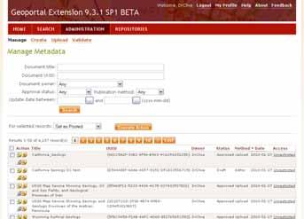
10 ArcGIS Server Geoportal Extension Enabling discovery and use of geospatial resources Search and view geospatial resources Manage, publish, and store metadata View live map services Download data

11 What we will Discuss/Demo 11
12 End users: I want to find data Simple keyword search Advanced options for experts Smart matching and ranking Search results must be simple to understand yet contain detail for power-users Point and click access I want to download data I want to know when new data are available 12

13 Search Results


14 I want to make a map Solution: Preview services: ArcGIS Server Map Services ArcIMS Image Services OGC WMS GeoRSS KML Provide integration points for map viewer platforms JavaScript, Flex, Silverlight ArcGIS Desktop ArcMap ArcGIS Explorer


15 I want to know when new data is available Solution: User specifies search criteria Give user link to a GeoRSS feed User subscribes to GeoRSS feed geoportal


16 I want to download data Solution: Link to a file or Clip-Zip-Ship Provide an ordering page with simple choices Based on Geoprocessing Service Extensible in Python

17 DEMO
18 Service providers: I want to advertise my data Give user choices for publishing metadata: Create metadata online Upload metadata Register SDI catalog site for harvesting Just register the service endpoint! Support metadata standards ISO 19115/19, FGDC INSPIRE 18


19 Publish What? Live services E.g., ArcGIS Server, WMS, WFS, WCS, CS-W, ArcIMS Downloadable Data Feature Classes in Geodatabases Geospatial applications Documents Etc 19

20 DEMO
21 Security Restricting Access to Metadata 1. Unrestricted All (approved) documents are visible to all users 2. Public-Protected Public documents are visible to all users Only members of 1 specific group see the protected documents 3. Restricted Unrestricted documents are visible to all users Restricted documents are accessible only to groups that have been granted access to the documents All interfaces to Geoportal apply the same policy Public-only and authenticating endpoints for CS-W and REST Authentication and Authorization through LDAP/AD


22 Restrict Access to Metadata Anonymous user Only Sees Public metadata


23 Restrict Access to Metadata Control Access to Metadata at Document Level


24 Restrict Access to Metadata Authenticated User Also Sees Restricted Content


 CSW REST API")

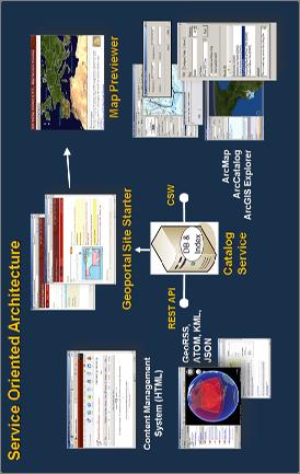
25 Service Oriented Architecture Map Previewer Geoportal Site Starter Content Management System (HTML) CSW REST API GeoRSS, ATOM, KML, JSON Catalog Service ArcMap ArcCatalog ArcGIS Explorer
26 Platforms Go Beyond Application Silos Service Oriented Architectures a Framework for Integration Web 1.0 Web Client Services Oriented Architecture (SOA) Desktop Client Web Client Mobile Client Interconnected Interoperable Integrative Dynamic Enterprise Service Bus Highest Point Service Point-to-Point Services Highest Point Service Terrain Service Loosely Coupled and Orchestrated Services
27 ESRI Geoportal Services Geoportal Provides: OGC CS-W Discovery Interface Supports interoperability with all OGC CSW standard services REST Discovery Interface Supports OpenSearch Supported Output Formats: GeoRSS, ATOM, HTML, KML, and JSON Supported Filters: Free Text, Spatial Extent, Content Type, Data Category, Update Date Search Widget Geoportal Consumes: OGC CS-W, Z39.50, ArcIMS, WAF, OAI for metadata OGC W*S, ArcGIS Server, ArcIMS, KML, GeoRSS for display


28 Example: Data.gov Data.gov new initiative to transparent government Data.gov looked at building yet another catalog for data Geodata.gov and Data.gov collaborated Geodata.gov now supplies Data.gov with 160,000+ downloadable datasets through an OGC Catalog Service

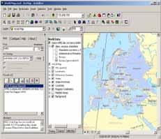
29 Geoportal Desktop Client Tools Search Client Add-in for ArcMap & ArcGIS Explorer Search CS-W Catalogs for metadata and services View Metadata Footprints Add to Map/Globe Common Architecture and User Experience Publish Client for ArcCatalog Functionality for batch uploading metadata records from ArcCatalog Scrapes metadata from single files, folders, feature classes and geodatabases Free downloads from esri.com! 29


30 Search Widgets HTML Widget Embed Geoportal search within another web site Flex Widget Uses Geoportal REST interface for Search functionalities Viewing metadata Visualizing OGC WMS, GeoRSS, 30

31 DEMO
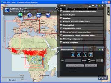
32 Example: Web Flex Viewer with search widget Discover, View and combine shared data Discovered and use resources Processing functionalities Technology behind the scenes ESRI Flex Mapping API and the ESRI Flex Viewer for Visualizing OGC WMS, GeoRSS, ESRI Geoportal REST interface for Search ArcGIS Server for Map services Processing (calculate population, )

33 Geoportal Extension for ArcGIS Server Context within an Enterprise Spatial Data Infrastructure ESRI Geoportal What s coming at ArcGIS 10 Resources
34 Design Goal: Unify Structured Content with Unstructured Resources Large User Community: General Users Brief Metadata is Sufficient Tagging, Dublin Core, Limited User Community: GIS Specialist Emergency Responder Verbose Metadata is Desired ISO 19139, FGDC Metadata Profiles


35 Geoportal Version 10 Discovery and Access of Unstructured Content Customizable Search Adapters Interoperability using OpenSearch YouTube Microsoft Sharepoint Flickr

36 Geoportal Version 10 Additional Search Providers and Federated Search CS-W ArcGIS Server Search Services Z39.50 Sources Image Catalogs Geodata Services WFS Services


37 Geoportal 10 Synchronize Catalogs Looking at synchronizing multiple catalogs Driven by enterprise needs Near real-time Multi-directional Sync Metadata for Services Generate Update Delete
38 Geoportal 10 Server-side Harvesting Re-harvesting servers and uploaded services Harvest (geoportal) sitemaps Harvest geodata services (sync) Harvest ArcGIS Servers (sync) Retire desktop harvesting tool Retire desktop harvesting service Supports pure Linux implementation Harvesting and Directed Searching closely related

39 Geoportal Version 10 Identity Management OpenID/Oauth Group-level administrators

40 Geoportal 10 Silverlight Widget

41 Geoportal 10 Index Statistics Browse by metadata facets: More like categories in retail store websites Not editable, based on catalog content Exposed through REST Use to build: Browsing capabilities Word clouds Content Channels Reports for Administrators


42 Geoportal 10 Expand on ArcGIS Online Integration
43 Geoportal 10 Recap Expand Directed Search Framework Federate searches to more than one site Server-side Harvesting Synchronize Catalogs Silverlight Search Widget Index Statistics Exploit Geoportal Usage Expand use of ontology service Identity Management Update Desktop Clients
44 Geoportal Extension for ArcGIS Server Context within an Enterprise Spatial Data Infrastructure ESRI Geoportal What s coming at ArcGIS 10 Resources
45 Useful Links ESRI Geoportal: Public ESRI Geoportal : ESRI Webhelp : Geo Flex viewer with Search widget and some processing functionalities: ESRI mapping APIs (Flex, JavaScript, SilverLight):

46 Contacts SDI Solutions Team )

47 Platform Support Operating System: Windows XP Professional SP3 Windows 2003 Server 32-bit Windows 2003 Server 64-bit Windows 2008 Server 32-bit Redhat Linux 32-bit Database: Oracle 9i Oracle 10g Oracle 11g Microsoft SQL Server 2005 Microsoft SQL Server 2008 PostgreSQL 8.3 Servlet engine: Apache Tomcat 5.x Apache Tomcat 6.x Sun Glassfish Oracle WebLogic Application Server 10 ArcGIS Server Enterprise Standard 9.3.1
How to become an INSPIRE node and fully exploit the investments made?
 How to become an INSPIRE node and fully exploit the investments made? Solution patterns for consumers: end users & developers (2/2) Roberto Lucchi 22 June 2010, Krakow 1 Geoportal extension Enabling discovery
Discovery and Access of Geospatial Resources Using GIS Portal Toolkit Marten Hogeweg Product Manager GIS Portal Toolkit
 Discovery and Access of Geospatial Resources Using GIS Portal Toolkit Marten Hogeweg Product Manager GIS Portal Toolkit Outline Elements of Spatial Data Infrastructures Current trends Position of GIS portals
Esri Geoportal Server
 Esri Geoportal Server Implementing a Spatial Data Infrastructure @martenhogeweg Esri Geoportal Server Extending ArcGIS to enable discovery and use of geospatial resources in heterogeneous environments
Geospatial Commons Workgroup Meeting with ESRI Thursday April 29, :30 11:30 AM Centennial Office Building, Nokomis Conference Room.
 Geospatial Commons Workgroup Meeting with ESRI Thursday April 29, 2010 9:30 11:30 AM Centennial Office Building, Nokomis Conference Room. Workgroup Members in attendance: Chris Cialek, Mark Kotz, Susan
Leveraging OGC Services in ArcGIS Server. Satish Sankaran, Esri Yingqi Tang, Esri
 Leveraging OGC Services in ArcGIS Server Satish Sankaran, Esri Yingqi Tang, Esri GIS Creating and Managing Geo Information Products - Proprietary - Open Specifications - Standards Dissemination of Geo
Leveraging OGC Standards on ArcGIS Server
 Leveraging OGC Standards on ArcGIS Server Satish Sankaran Interoperability and Standards Team James Michel III ESRI Intel Team ArcGIS Server Complete Interoperable Server-Based GIS Desktop Explorer Web
INSPIRE: The ESRI Vision. Tina Hahn, GIS Consultant, ESRI(UK) Miguel Paredes, GIS Consultant, ESRI(UK)
 Miguel Paredes, GIS Consultant, ESRI(UK)") INSPIRE: The ESRI Vision Tina Hahn, GIS Consultant, ESRI(UK) Miguel Paredes, GIS Consultant, ESRI(UK) Overview Who are we? Introduction to ESRI Inc. and ESRI(UK) Presenters ArcGIS The ESRI Solution to
INSPIRE: The ESRI Vision Tina Hahn, GIS Consultant, ESRI(UK) Miguel Paredes, GIS Consultant, ESRI(UK) Overview Who are we? Introduction to ESRI Inc. and ESRI(UK) Presenters ArcGIS The ESRI Solution to
ArcGIS Online. The Road Ahead Geoff Mortson
 ArcGIS Online The Road Ahead Geoff Mortson gmortson@esricanada.com ArcGIS Online Easily create and share maps Delivered as intelligent maps Access on virtually any device anyone, anywhere Compliments and
GEOSPATIAL ERDAS APOLLO. Your Geospatial Business System for Managing and Serving Information
 GEOSPATIAL ERDAS APOLLO Your Geospatial Business System for Managing and Serving Information ERDAS APOLLO Do you have large volumes of data, a geographicallydistributed user base and rapidly changing
SDI SOLUTIONS FOR INSPIRE: TECHNOLOGIES SUPPORTING A FRAMEWORK OF COOPERATION
 SDI SOLUTIONS FOR INSPIRE: TECHNOLOGIES SUPPORTING A FRAMEWORK OF COOPERATION Roberto Lucchi 1, Marten Hogeweg 1, Guenther Pichler 2 1 Esri, Redlands, CA, USA 2 Esri Kranzberg, Germany 1 Vision INSPIRE
PRODUCT BROCHURE ERDAS APOLLO MANAGING AND SERVING GEOSPATIAL INFORMATION
 PRODUCT BROCHURE ERDAS APOLLO MANAGING AND SERVING GEOSPATIAL INFORMATION ERDAS APOLLO Do you have large volumes of geospatial information, regularly updated data stores, and a distributed user base? Do
Leveraging metadata standards in ArcGIS to support Interoperability. Aleta Vienneau and Marten Hogeweg
 Leveraging metadata standards in ArcGIS to support Interoperability Aleta Vienneau and Marten Hogeweg Leveraging metadata standards in ArcGIS to support Interoperability Overview of metadata standards
ERDAS APOLLO Managing and Serving Geospatial Information
 ERDAS APOLLO Managing and Serving Geospatial Information ERDAS APOLLO Do you have large volumes of geospatial information, regularly updated data stores, and a distributed user base? Do you need a single,
SMARTERDECISIONS. Geospatial Portal 2013 Open Interoperable GIS/Imagery Services with ERDAS Apollo 2013 and ERDAS Imagine 2013
 Geospatial Portal 2013 Open Interoperable GIS/Imagery Services with ERDAS Apollo 2013 and ERDAS Imagine 2013 Carahsoft Intergraph Government Solutions SMARTERDECISIONS Geospatial Portal 2013 Geospatial
Achieving Interoperability Using Open Standards
 FedGIS Conference February 24 25, 2016 Washington, DC Achieving Interoperability Using Open Standards Satish Sankaran Marten Hogeweg Agenda Understanding Interoperability What, Why and How? ArcGIS Platform
Understanding and Using Metadata in ArcGIS. Adam Martin Marten Hogeweg Aleta Vienneau
 Understanding and Using Metadata in ArcGIS Adam Martin Marten Hogeweg Aleta Vienneau Adam Martin National Government Account Management R&D Open Data Marten Hogeweg National Government Professional Services
Providing Interoperability Using the Open GeoServices REST Specification
 2013 Esri International User Conference July 8 12, 2013 San Diego, California Technical Workshop Providing Interoperability Using the Open GeoServices REST Specification Satish Sankaran Kevin Sigwart What
Achieving Interoperability using the ArcGIS Platform. Satish Sankaran Roberto Lucchi
 Achieving Interoperability using the ArcGIS Platform Satish Sankaran Roberto Lucchi Thank you Please fill out the session survey in your mobile app Select [Achieving Interoperability using the ArcGIS Platform]
The GeoPortal Cookbook Tutorial
 The GeoPortal Cookbook Tutorial Wim Hugo SAEON/ SAEOS SCOPE OF DISCUSSION Background and Additional Resources Context and Concepts The Main Components of a GeoPortal Architecture Implementation Options
The geospatial metadata catalogue. FOSS4G Barcelona. Jeroen Ticheler. Founder and chair. Director
 The geospatial metadata catalogue FOSS4G2010 - Barcelona Jeroen Ticheler Director Founder and chair GeoNetwork opensource Dutch National Geo Registry FAO GeoNetwork SwissTopo geocat.ch GeoNetwork history
Introduction to ArcGIS Server Architecture and Services. Amr Wahba
 Introduction to ArcGIS Server 10.1 - Architecture and Services Amr Wahba awahba@esri.com Agenda Architecture Features Publishing Security Cloud Powerful GIS capabilities Delivered as Web services To help
ArcGIS Viewer for Microsoft Silverlight An Introduction
 Esri International User Conference San Diego, CA Technical Workshops July 12, 2011 ArcGIS Viewer for Microsoft Silverlight An Introduction Art Haddad, Rich Zwaap, and Derek Law Agenda Background Product
Working with the ArcGIS Viewer for Flex Application Builder
 Working with the ArcGIS Viewer for Flex Application Builder Esri Canada User Conference St. John s November 15, 2012 Presented By: Greg Yetman gyetman@esri.ca Agenda This seminar is designed to help you
Interoperability and Standards Supports in ArcGIS
 Esri International User Conference San Diego, California Technical Workshops July 26, 2012 Interoperability and Standards Supports in ArcGIS Satish Sankaran, Esri Yingqi Tang, Esri Agenda Esri s participation
Extend GIS. The Reach. Of Your GIS. Chris Cappelli Nathan Bennett
 Extend The Reach GIS Of Your GIS Chris Cappelli Nathan Bennett Where do your co-workers, managers, customers, and citizens go when they want to find or make a map? GIS is a practical system for problem
Interoperability with ArcGIS
 Interoperability with ArcGIS Satish Sankaran Marten Hogeweg Agenda Understanding Interoperability What, Why and How? ArcGIS Platform An Open Platform Supporting Interoperability Examples from the real
Esri Support for Geospatial Standards
 APRIL 2017 ArcGIS Is Open and Interoperable Esri Support for Geospatial Standards Copyright 2017 Esri All rights reserved. Printed in the United States of America. The information contained in this document
Working with Metadata in ArcGIS
 Esri International User Conference San Diego, California Technical Workshops July 26, 2012 Working with Metadata in ArcGIS Aleta Vienneau Metadata in ArcGIS ArcGIS metadata goals Editing metadata Setting
Introduction to ArcGIS Server 10.1
 Introduction to ArcGIS Server 10.1 E-Learning for the GIS Professional Any Time, Any Place! geospatialtraining.com Module Outline What is ArcGIS Server? GIS Resources and Services ArcGIS Server Components
Enterprise Architecture Deployment Options. Mark Causley Sandy Milliken Sue Martin
 Enterprise Architecture Deployment Options Mark Causley Sandy Milliken Sue Martin GIS is Being Implemented in Many Settings Organization Business to Business Department Workgroup GIS is Moving to the Enterprise
ArcGIS 9.2 Works as a Complete System
 ArcGIS 9.2 Works as a Complete System A New Way to Manage and Disseminate Geographic Knowledge Author/Serve/Use Maps Data Models Globes Metadata Use Desktop Explorer Web Map Viewer Mobile Open APIs Enterprise
Web GIS: Principles and Applications. Pinde Fu, Ph.D. Project Lead / Senior Developer Professional Services Division
 Web GIS: Principles and Applications Pinde Fu, Ph.D. pfu@esri.com Project Lead / Senior Developer Professional Services Division 2 Web GIS: Principles and Applications Pinde Fu & Jiulin Sun Web GIS course
The GEO Discovery and Access Broker
 WGISS-43 The GEO Discovery and Access Broker S. Nativi (1), M. Santoro (1) (1) Institute of Atmospheric Pollution Research, National Research Council of Italy DOWNSTREAM MIDSTREAM end-users Applications
Leveraging OGC Services in ArcGIS Server. Satish Sankaran Yingqi Tang
 Leveraging OGC Services in ArcGIS Server Satish Sankaran ssankaran@esri.com Yingqi Tang ytang@esri.com Agenda Interoperability Enablers OGC and esri OGC Web Services ArcGIS and OGC Web Services - @ version
GeoNode Integration with SDIs and Community Mapping
 GeoNode Integration with SDIs and Community Mapping Salvador Bayarri sbayarri@gmail.com World Bank Consultant Contents Accessing other SDI services Catalog harvesting through Geonetwork Cascading external
What s New in ArcGIS 10.4 for Server
 What s New in ArcGIS 10.4 for Server Derek Law, Esri Jan 19, 2016 Esri Southwest User Conference Agenda Product story GIS Server Sharing content from ArcGIS Pro Portal for ArcGIS Client Apps Summary Strongly
Managing Image Data on the ArcGIS Platform Options and Recommended Approaches
 Managing Image Data on the ArcGIS Platform Options and Recommended Approaches Peter Becker Petroleum requirements for imagery and raster Traditional solutions and issues Overview of ArcGIS imaging capabilities
Getting Started with ArcGIS for Server. Charmel Menzel and Ken Gorton
 Getting Started with ArcGIS for Server Charmel Menzel and Ken Gorton Agenda What is ArcGIS for Server? Types of Web services Publishing resources onto the Web Clients to ArcGIS for Server Editions and
Desktop. ArcGIS Server. ArcGIS
 Getting Started with ArcGIS Server Nakul Bhatia and David Crosby ESRI Charlotte 1 Agenda g Overview of ArcGIS Server 9.3.1 Working with GIS Services Using g Web GIS Service Clients ArcGIS Online Map Caching
An Introduction to GIS for developers
 An Introduction to GIS for developers Part 4: GIS Sharing Canserina Kurnia & Tom Shippee Agenda Web GIS ArcGIS Online Cloud-based ArcGIS Server ArcGIS Server on-premises ArcGIS a complete platform discover,
International Organization for Standardization Technical Committee 211 (ISO/TC211)
") Esri Support for Geospatial Standards: Open Geospatial Consortium (OGC) International Organization for Standardization Technical Committee 211 (ISO/TC211) An Esri White Paper April 2015 Copyright 2015
Esri Support for Geospatial Standards: Open Geospatial Consortium (OGC) International Organization for Standardization Technical Committee 211 (ISO/TC211) An Esri White Paper April 2015 Copyright 2015
Creating Mosaic Datasets and Publishing Image Services using Python
 Creating Mosaic Datasets and Publishing Image Services using Python Jie Zhang, Jamie Drisdelle Session Offering ID: 305 Overview Introduction to mosaic dataset Raster product for sensor imagery Automatic
Scientific and Multidimensional Raster Support in ArcGIS
 Scientific and Multidimensional Raster Support in ArcGIS Sudhir Raj Shrestha sshrestha@esri.com Brief breakdown Scientific Multidimensional data Ingesting Scientific MultiDim Data in ArcGIS Ingesting and
The What, Why, Who and How of Where: Building a Portal for Geospatial Data. Alan Darnell Director, Scholars Portal
 The What, Why, Who and How of Where: Building a Portal for Geospatial Data Alan Darnell Director, Scholars Portal What? Scholars GeoPortal Beta release Fall 2011 Production release March 2012 OLITA Award
ICIT. Brian Hiller ESRI Account Manger. What s new in ArcGIS 10
 ICIT Brian Hiller ESRI Account Manger What s new in ArcGIS 10 ArcGIS 10 Fast Easy Powerful Everywhere late June 2010 ArcGIS System for Geographic Information Desktop Server Mobile Online A System A Complete
Metadata for Data Discovery: The NERC Data Catalogue Service. Steve Donegan
 Metadata for Data Discovery: The NERC Data Catalogue Service Steve Donegan Introduction NERC, Science and Data Centres NERC Discovery Metadata The Data Catalogue Service NERC Data Services Case study:
What s New in ArcGIS Server 10
 What s New in ArcGIS Server 10 Derek Law ArcGIS Server Product Management What s s new in ArcGIS Server 10? Agenda Highlights: Enhanced Web mapping More powerful server-based analysis Geo-collaboration
GeoPortal 4 Everybody
 GeoPortal 4 Everybody Karel Charvát, Jáchym Čepický, Štěpán Kafka, Premysl Vohnout, Martin Vlk Czech Centre for Science and Society Help Service Remote Sensing DT Member What is GeoPortal GeoPortal is
Understanding and using Metadata across the ArcGIS Platform. Aleta Vienneau Marten Hogeweg
 Understanding and using Metadata across the ArcGIS Platform Aleta Vienneau Marten Hogeweg Understanding and using Metadata across the ArcGIS Platform Metadata fundamentals ArcGIS platform Road ahead Metadata
Web Mapping Applications with ArcGIS. Bernie Szukalski Derek Law
 Web Mapping Applications with ArcGIS Bernie Szukalski Derek Law Agenda Web Mapping and Map Services Fundamentals ArcGIS Web Mapping Applications - Hosted online - Hosted on-premise Summary Web Application
GEOPORTAL SOLUTIONS BASED ON ESRI GIS PLATFORM IN SOUTHEAST EUROPE. Dejan KRSTEVSKI 1
 GEOPORTAL SOLUTIONS BASED ON ESRI GIS PLATFORM IN SOUTHEAST EUROPE Dejan KRSTEVSKI 1 ABSTRAKT The concept of spatial data infrastructure (SDI) has emerged and continues to advance as a framework for organizing
SuperGIS Server 3.2 Value Edition Specification
 SuperGIS Server 3.2 Value Edition Specification 20140826 Specification 1. All of the services support SOAP (Simple Object Access Protocol). 2. Use map file created by SuperGIS Desktop as map services SuperGIS
From Geoportal to Spatial Data Service Platform. Jani Kylmäaho National Land Survey of Finland Development Centre
 From Geoportal to Spatial Data Service Platform Jani Kylmäaho National Land Survey of Finland Development Centre Introduction National Land Survey of Finland - 1900 employees Development Centre - 120 employees
THE GEOSS PLATFORM TOWARDS A BIG EO DATA SYSTEM LINKING GLOBAL USERS AND DATA PROVIDERS
 THE PLATFORM TOWARDS A BIG EO DATA SYSTEM LINKING GLOBAL USERS AND DATA PROVIDERS J. Van Bemmelen (1), P. De Salvo (2), M. Santoro (3), P. Mazzetti (3), G. Colangeli (1), S. Nativi (4) (1) European Space
Dynamic Situational Awareness. Through Developer Applications
 Dynamic Situational Awareness Through Developer Applications Mission Focused Applications Building Apps to support operations Agile Simple High-Performance Defense Developers GIS Simplifies Working With
Building and Deploying Enterprise ArcGIS Server Solutions (Best Practices) Wittaker Mathot Developer Summit
 Wittaker Mathot Developer Summit") Building and Deploying Enterprise ArcGIS Server Solutions (Best Practices) Wittaker Mathot Developer Summit 2007 1 Presentation Goals See real world, Enterprise implementations of ArcGIS Server presented
Building and Deploying Enterprise ArcGIS Server Solutions (Best Practices) Wittaker Mathot Developer Summit 2007 1 Presentation Goals See real world, Enterprise implementations of ArcGIS Server presented
EUCOM/AFRICOM DEFENSE USER GROUP MEETING MARCH 2010 STUTTGART WELCOME!
 EUCOM/AFRICOM DEFENSE USER GROUP MEETING 23-25 MARCH 2010 STUTTGART WELCOME! AGENDA March 23, Tuesday 0800-0900 Registration 0900-0915 Welcome and Introductions 0915-1000 Getting Started with ArcGIS Server
Esri Support for Geospatial Standards: OGC and ISO/TC211. An Esri White Paper May 2015
 Esri Support for Geospatial Standards: OGC and ISO/TC211 An Esri White Paper May 2015 Copyright 2015 Esri All rights reserved. Printed in the United States of America. The information contained in this
ArcGIS Online: Managing Data. Jeremy Bartley Sentha Sivabalan
 ArcGIS Online: Managing Data Jeremy Bartley (jbartley@esri.com) Sentha Sivabalan (ssivabalan@esri.com) Agenda Creating and managing content like Apps, Maps, Scenes and Layers in ArcGIS Today s Topics:
ArcGIS Server: publishing geospatial data to the web using the EEA infrastructure
 ArcGIS Server: publishing geospatial data to the web using the EEA infrastructure *IMPORTANT: Map Services should be published using the EEA Map Services Tick Sheet for guidance. Contact Sebastien Petit
Leveraging OGC Services in ArcGIS Server
 Esri International User Conference San Diego, CA Technical Workshops Jul.14 th 2011 Leveraging OGC Services in ArcGIS Server Satish Sankaran Yingqi Tang Agenda Interoperability
3D in the ArcGIS Platform. Chris Andrews
 3D in the ArcGIS Platform Chris Andrews Geospatial 3D is already all around us 3D is expanding the GIS community s opportunity to provide value 3D City & Infrastructure Models Generated 3D features Photogrammetrc
ArcGIS for Server Michele Lundeen
 ArcGIS for Server 10.1 Michele Lundeen Summary Vision Installation and Configuration Architecture Publishing Functional Enhancements Cloud Migration and Best Practices Powerful GIS capabilities Delivered
Spatial Data on the Web
 Spatial Data on the Web Tools and guidance for data providers The European Commission s science and knowledge service W3C Data on the Web Best Practices 35 W3C/OGC Spatial Data on the Web Best Practices
Multi-disciplinary Interoperability: the EuroGEOSS Operating Capacities
 Multi-disciplinary Interoperability: the EuroGEOSS Operating Capacities Stefano Nativi (CNR) stefano.nativi@cnr.it Opening and context for Global Dimension Stream: EuroGEOSS contribution to the Global
Compass INSPIRE Services. Compass INSPIRE Services. White Paper Compass Informatics Limited Block 8, Blackrock Business
 Compass INSPIRE Services White Paper 2010 Compass INSPIRE Services Compass Informatics Limited Block 8, Blackrock Business Park, Carysfort Avenue, Blackrock, County Dublin, Ireland Contact Us: +353 1 2104580
ArcGIS for Server: What s New. Philip Heede, Jay Theodore
 ArcGIS for Server: What s New Philip Heede, Jay Theodore Agenda GIS server Web GIS: Portal for ArcGIS ArcGIS for Server Extensions - GeoEvent Extension - Production Mapping Primary target for new functionality
SDI Tecnological Components and Standards
 SDI Tecnological Components and Standards Salvador Bayarri sbayarri@gmail.com World Bank Consultant Contents The SDI architecture model Software components: the SDI stack Basic services Metadata SDI access
Presented by Kit Na Goh
 Developing A Geo-Spatial Search Tool Using A Relational Database Implementation of the FGDC CSDGM Model Presented by Kit Na Goh Introduction Executive Order 12906 was issued on April 13, 1994 with the
Developing a Free and Open Source Software based Spatial Data Infrastructure. Jeroen Ticheler
 Developing a Free and Open Source Software based Spatial Data Infrastructure Jeroen Ticheler 1 License This work is licensed under the Creative Commons Attribution-NonCommercial-ShareAlike 2.5 License.
GENeric European Sustainable Information Space for Environment.
 GENeric European Sustainable Information Space for Environment http://www.genesis-fp7.eu/ Outline Introduction The GENESIS FP7 project The GENESIS solution s architecture GENESIS experience with INSPIRE
Using ArcGIS for Server. Javier Abadía, Esri España Peter McDaid, Esri UK
 Using ArcGIS for Server Javier Abadía, Esri España Peter McDaid, Esri UK 1. Intro 2. ArcGIS for Server = Geospatial Apps Server 3. Map Services Publishing Flow Apps 4. Spatial Functionality Services Publishing
The Value of Metadata
 The Value of Metadata Why is metadata important to your agency / organization? Metadata has tremendous value to Individuals within your organization, as well as to individuals outside of your organization
Geospatial Enterprise Search. June
 Geospatial Enterprise Search June 2013 www.voyagersearch.com www.voyagersearch.com/demo The Problem: Data Not Found The National Geospatial-Intelligence Agency is the primary source of geospatial intelligence
Advanced Standard Basic Notes
 9.3 Functionality Matrix Data Management Scalable Geodatabase Access Full Geodatabase Support Create Geodatabases Load Spatial Data into Geodatabases Manage Geodatabases One-Way Replication Two-Way Replication
ArcGIS Enterprise: Architecture & Deployment. Anthony Myers
 ArcGIS Enterprise: Architecture & Deployment Anthony Myers 1 2 3 4 5 Web GIS Overview of ArcGIS Enterprise Federation & Hosted Server Deployment Patterns Implementation 1 Web GIS ArcGIS Enabling GIS for
Integrated Map Tool. Overview, Current Status, and Things to Come
 Integrated Map Tool Overview, Current Status, and Things to Come Integrated Mapping and Analysis Tool (IMAT) map widget Integrated Mapping Tool IMAT Reusable components for portrayal, query, analysis,
ESRI Technology Update. Joe Holubar Larry Young
 ESRI Technology Update Joe Holubar Larry Young Continued Improvement Improving Quality and Extending and Refining Functionality First Half of 2009: Minor Update Release (ArcGIS 9.3.1) ArcGIS Explorer Fall
Installing ArcIMS 9.1 on Windows
 ArcGIS 9.1 Installing ArcIMS 9.1 on Windows Table Of Contents Introduction...1 Overview...2 What s included with ArcIMS 9.1?...2 ArcIMS components...2 ArcIMS Manager...3 ArcIMS Manager Applications...3
FME / ArcGIS 9 Data Interoperability Extension
 FME / ArcGIS 9 Data Interoperability Extension About us Founded: 1993 Head office: Vancouver, Canada # of Employees: 45 Target markets: GIS & GPS vendors, Telecom and utilities, Oil & gas, Government agencies
Overview of ArcGIS Solutions in Service-Oriented Architectures. Dave Wrazien Michael Young
 Overview of ArcGIS Solutions in Service-Oriented Architectures Dave Wrazien Michael Young Overview Introductions ArcGIS Architecture Implementation Options SOA Overview Web Services Overview ArcGIS SOA
Metadata Topic Harmonization and Semantic Search for Linked-Data-Driven Geoportals -- A Case Study Using ArcGIS Online
 Metadata Topic Harmonization and Semantic Search for Linked-Data-Driven Geoportals -- A Case Study Using ArcGIS Online Yingjie Hu 1, Krzysztof Janowicz 1, Sathya Prasad 2, and Song Gao 1 1 STKO Lab, Department
/// INTEROPERABILITY BETWEEN METADATA STANDARDS: A REFERENCE IMPLEMENTATION FOR METADATA CATALOGUES
 /// Position Paper /// INTEROPERABILITY BETWEEN METADATA STANDARDS: A REFERENCE IMPLEMENTATION FOR METADATA CATALOGUES /// Keywords: Public administration, Metadata, Geographical Information, Geospatial
Carmenta Server Product Description
 White paper Carmenta Server Product Description Carmenta AB, Tel +46-31-775 57 00, www.carmenta.com P315 121RD, 2010 Carmenta reserves the right to change the specifications at any time and without notice.
METAINFORMATION INFRASTRUCTURE FOR GEOSPATIAL INFORMATION
 2010/2 PAGES 1 7 RECEIVED 15. 6. 2009 ACCEPTED 2. 3. 2010 T. KLIMENT METAINFORMATION INFRASTRUCTURE FOR GEOSPATIAL INFORMATION ABSTRACT Tomáš KLIMENT email: tomas.kliment@stuba.sk Research field: Spatial
Introduction to INSPIRE. Network Services
 Introduction to INSPIRE. Network Services European Commission Joint Research Centre Institute for Environment and Sustainability Digital Earth and Reference Data Unit www.jrc.ec.europa.eu Serving society
Publishing image services in ArcGIS
 Esri International User Conference San Diego, California Technical Workshops July 26, 2012 Publishing image services in ArcGIS Wenxue Ju & Melanie Harlow What is an image service? A way to make image and
SAFER the GIGAS Effect
 SAFER the GIGAS Effect How INSPIRE, GMES and GEOSS are influencing EC projects Arnaud Cauchy 23/06/2010 Agenda GIGAS Project Summary SAFER Project Summary SAFER Original Approach GIGAS Influences SAFER
Harvard Hypermap: An Open Source Framework for Making the World's Geospatial Information more Accessible
 American Association of Geographers Boston, Massachusetts April, 2017 Harvard Hypermap: An Open Source Framework for Making the World's Geospatial Information more Accessible Benjamin Lewis, Paolo Corti,
Outline. The Collaborative Research Platform for Data Curation and Repositories: CKAN For ANGIS Data Portal. Open Access & Open Data.
 Outline The Collaborative Research Platform for Data Curation and Repositories: CKAN For ANGIS Data Portal Open Access & Open Data ANGIS data portal New developed features Future works Hsiung-Ming Liao,
Best Practices for Designing Effective Map Services
 FedGIS Conference February 24 25, 2016 Washington, DC Best Practices for Designing Effective Map Services James Tedrick, Esri Matt Sokol, MD Dept. of Information Technology Web Mapping & Service Types
Energy Industry Profile An Update from the Metadata Work Group
 Energy Industry Profile An Update from the Metadata Work Group May 1, 2012 PUG Conference 2012 Houston, Texas Metadata Work Group Outline Metadata Initiative Background / EIP Overview 2012 Release of EIP
An Introduction to Data Interoperability
 Esri International User Conference San Diego, California 2012 Technical Workshops July 24/25 An Introduction to Data Interoperability Bruce Harold - Esri Dale Lutz Safe Software Background Why Data Interoperability?
ArcGIS Open Data. Matt Bullock
 ArcGIS Open Data Matt Bullock Why does open data matter? transparency accountability open data participation innovation economic development but is it accessible? FOIA requests FTP websites ArcGIS Open
IT Infrastructure for BIM and GIS 3D Data, Semantics, and Workflows
 IT Infrastructure for BIM and GIS 3D Data, Semantics, and Workflows Hans Viehmann Product Manager EMEA ORACLE Corporation November 23, 2017 @SpatialHannes Safe Harbor Statement The following is intended
SAW Stand-alone Application for Web GIS Configuration and Deployment. PhD. Bogdan Cheveresan Esri Romania
 SAW Stand-alone Application for Web GIS Configuration and Deployment PhD. Bogdan Cheveresan Esri Romania Web GIS Workflow Without SAW esri.com Desktop GIS User ArcGIS Server Administrator and Web GIS Programmer
Web App Builder: Code-free Development. Adam Ziegler, Esri-Northeast, Local Government Team
 Web App Builder: Code-free Development Adam Ziegler, aziegler@esri.com Esri-Northeast, Local Government Team Agenda Product overview Web AppBuilder for ArcGIS tour Adding Custom Widgets Community and Resources
Managing Imagery and Raster Data using Mosaic Datasets
 Esri European User Conference October 15-17, 2012 Oslo, Norway Hosted by Esri Official Distributor Managing Imagery and Raster Data using Mosaic Datasets Peter Becker ArcGIS is a Comprehensive Imagery
Tom Brenneman. Good morning and welcome, introductions and thank you for being here.
 Welcome Tom Brenneman Good morning and welcome, introductions and thank you for being here. This is a best practices seminar. We're going to be sharing with you what we found to be best practices that
Initial Operating Capability & The INSPIRE Community Geoportal
 INSPIRE Conference, Rotterdam, 15 19 June 2009 1 Infrastructure for Spatial Information in the European Community Initial Operating Capability & The INSPIRE Community Geoportal EC INSPIRE GEOPORTAL TEAM