Android Team Awareness Kit (ATAK) and ArcGIS
|
|
|
- Louise Blankenship
- 5 years ago
- Views:
Transcription
 and ArcGIS")


1 Android Team Awareness Kit (ATAK) and ArcGIS Darron Pustam Product Manager, Esri Craig Cleveland Product Engineer, Esri Verne LaClair Product Manager, PAR
2 Agenda Connecting Intel and Operations in Real Time Esri - PAR collaboration What is ATAK (Android Team Awareness Kit) ArcGIS Plugin for TAK The Road Ahead Q&A
3 Esri PAR Collaboration


4 Esri PAR Collaboration Past PAR has been providing solutions and essential services to our nations defense, intelligence, and public safety for 35 years Esri and PAR have collaborated successfully at a software engineering level for a number of years. PAR has been an Esri Business Partner for 20 years. Esri and PAR have a strong relationship and a solid history including implementing ISR solutions across the ArcGIS platform (ArcGIS Full Motion Video 2011-present)
5 Esri PAR Collaboration Present and Future Leveraging PAR s experience as the lead developer and integrator of the AFRL Android Tactical Assault Kit (ATAK) / Team Awareness Kit (TAK) application suite. Customers have been consistently asking to ingest and visualize content on TAK devices from ArcGIS, and in particular ArcGIS Enterprise. This plugin meets that need.
6 What is ATAK?


7 Team Awareness Kit (TAK) TAK is a mission planning, situational awareness and call for fires solution that uses offthe-shelf mobile computing devices that interoperates with operational networks (tactical radios, mesh net radios, WiFi and broadband). TAK is a software and hardware integration for Android, ios, and Windows platforms. TAK is a Government owned solution with growing set of specialized plug-in augmentations. Current Releases ATAK 3.7 WinTAK 1.7 itak 1.0


8 TAK Overview Operations Planning Situational Awareness Mission Execution TAK is the integration of commercial mobile computing, custom and open source software, and DoD operational peripherals.
 is an extensible moving map display with an open Application Programming Interface (API) for Android devices It supports multiple Department of Defense (DoD),")
9 What is ATAK? The Android Team Awareness Kit (ATAK) is an extensible moving map display with an open Application Programming Interface (API) for Android devices It supports multiple Department of Defense (DoD), Department of Justice (DoJ) and other Government Agencies (OGA) Provides imagery data, map overlays and information sharing to provide enhanced collaboration and Situational Awareness (SA) operating in tactical network environments
10 ArcGIS Plugin for TAK

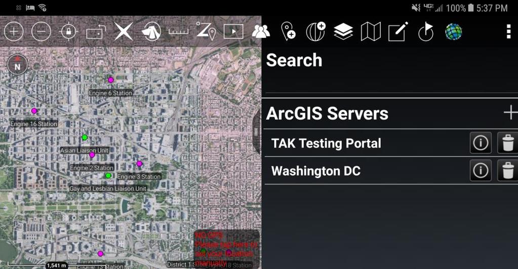
11 ArcGIS Plugin for TAK Introduction ATAK is an extensible moving map display with a broad user base across the DOD, IC, and Public Safety communities. Many of these users have robust ArcGIS deployments. The goal of the ArcGIS Plugin for TAK is to help users gain greater access to their ArcGIS data holdings, and ultimately help them better achieve their mission. The ArcGIS Plugin for TAK utilizes the plugin framework of ATAK, and can be added to a base ATAK deployment The plugin allows ATAK users to use their ArcGIS identity to authenticate against ArcGIS Online, or ArcGIS Enterprise, and access their ArcGIS content inside of ATAK.
12 ArcGIS Plugin for TAK Key Capabilities of the v1.0 Release Users will be able to access content from: - ArcGIS Online - Portal for ArcGIS - ArcGIS Server Content that can be consumed includes feature and map services, OGC services (WMS, WFS, WMTS), and a variety of file based data sources (shapefile, KML, GPX, CSV, and GeoPackage)
13 ArcGIS Plugin for TAK ArcGIS Online & Portal for ArcGIS Users accessing content from ArcGIS Online or their ArcGIS Enterprise portal will be able to: - Authenticate against their portal via built-in authentication - Query registered portal items for supported data types - Inspect item details of the returned results - Add and consume supported items to ATAK
14 ArcGIS Plugin for TAK ArcGIS Server Users accessing content from their ArcGIS Servers will be able to: - Authenticate against their ArcGIS Server via built-in authentication - Browse the REST endpoint - Add and consume supported service types feature, and map services, as well as WMS, WFS, and WMTS services
15 ArcGIS Plugin for TAK Services Once authenticated to ArcGIS Online, an ArcGIS Enterprise portal or ArcGIS Server, users consuming Esri services will be able to: - Render the service will the same symbology as it was published - Identify features - Cache features locally for offline use


16 ArcGIS Plugin for TAK Demonstration
17 Release Schedule Version 1.0 April Coincident with the 3.8 release of ATAK Version 1.1 ~July Esri International UC Version 1.2 ~September
18 The Road Ahead
19 The Road Ahead Version Support for additional authentication mechanisms - IWA, PKI, and SAML - Ability to view content via portal groups - Feature service editing Version Stream tracks to ArcGIS Enterprise
20 Situational Awareness
21 The need for real-time Situational Awareness spans across Industries Humanitarian Aid /Disaster Relief Fire & Emergency Services Law Enforcement Homeland Security / Border Security Safe Communities Military Command & Control Cyber Security Organizational boundaries Individual Team Operation Organization / Agency Multi-Agency Multi-National
22 Common Requirements for Real-Time Situational Awareness High performance Decluttered view of information - Real-time analysis - Real-time alerts - Intelligent entities / objects Collaboration - Geo-chat - Simple markup and share 2D / 3D Sensor Integration - Full motion video Flexible Access to Network comms - Peer-to-peer & mesh networks Data persistence - Mission logging & playback - Temporal and trend analysis
23 Q&A Android Team Awareness Kit (ATAK) and ArcGIS

24 Print Your Certificate of Attendance Print stations located in the 140 Concourse Tuesday 12:30 pm 6:30 pm GIS Solutions Expo Hall B Wednesday 10:30 am 5:15 pm GIS Solutions Expo Hall B 5:00 pm 6:30 pm GIS Solutions Expo Social Hall B 6:30 pm 9:00 pm Networking Reception Smithsonian National Portrait Gallery


25 Download the Esri Events app and find your event Please Take Our Survey in the Esri Events App Select the session you attended Scroll down to find the feedback section Complete answers and select Submit


26
Building Great Situational Awareness Apps Using ArcGIS Developer Tools. Kerry Robinson Eric Bader Thomas Solow
 Building Great Situational Awareness Apps Using ArcGIS Developer Tools Kerry Robinson Eric Bader Thomas Solow Agenda Situational Awareness in ArcGIS Developing apps in connected environments - ArcGIS Enterprise
Application of GIS to Cybersecurity. Brian Biesecker Ken Mitchell
 Application of GIS to Cybersecurity Brian Biesecker Ken Mitchell Fundamental Problems that GIS can help you solve What are the impacts to your mission, operations, business activities, critical systems,
ArcGIS Enterprise Security: An Introduction. Randall Williams Esri PSIRT
 ArcGIS Enterprise Security: An Introduction Randall Williams Esri PSIRT Agenda ArcGIS Enterprise Security for *BEGINNING to INTERMIDIATE* users ArcGIS Enterprise Security Model Portal for ArcGIS Authentication
ICAP - Intelligence Configuration for ArcGIS Pro. Natalie Feuerstein Dan Barnes Joe Bayles
 ICAP - Intelligence Configuration for ArcGIS Pro Natalie Feuerstein Dan Barnes Joe Bayles Overview Intelligence Analyst supporting Operations ArcGIS Pro SDK Intelligence Configuration for ArcGIS Pro -
Collector for ArcGIS: What s New. Chris LeSueur & James Tedrick
 Collector for ArcGIS: What s New Chris LeSueur & James Tedrick Outline Product overview Workflows Preparing data for Collector for ArcGIS What s new in Collector for ArcGIS v18.1.0 (Aurora) Advanced topics
Dynamic Situational Awareness. Through Developer Applications
 Dynamic Situational Awareness Through Developer Applications Mission Focused Applications Building Apps to support operations Agile Simple High-Performance Defense Developers GIS Simplifies Working With
ArcGIS Enterprise: Performance and Scalability Best Practices. Darren Baird, PE, Esri
 ArcGIS Enterprise: Performance and Scalability Best Practices Darren Baird, PE, Esri dbaird@esri.com What is ArcGIS Enterprise What s Included with ArcGIS Enterprise ArcGIS Server the core web services
High Availability & Disaster Recovery. Witt Mathot
 High Availability & Disaster Recovery Witt Mathot Managing the Twin Risks to your Operations Data Loss Down Time Business Continuity Terminology Resiliency High Availability RTO Round Robin Cost Business
Creating Geoprocessing Services and Web Tools. Darren Baird, PE, Esri
 Creating Geoprocessing Services and Web Tools Darren Baird, PE, Esri Introduction Both ArcMap and ArcGIS Pro are covered Terms Geoprocessing Services and Web Tools are the same - ArcMap publishes geoprocessing
ArcGIS Enterprise Security: An Introduction. Gregory Ponto & Jeff Smith
 ArcGIS Enterprise Security: An Introduction Gregory Ponto & Jeff Smith Agenda ArcGIS Enterprise Security Model Portal for ArcGIS Authentication Authorization Building the Enterprise Encryption Collaboration
Survey123 for ArcGIS: An Introduction. James Tedrick Erin Densford
 Survey123 for ArcGIS: An Introduction James Tedrick Erin Densford Smart Forms for ArcGIS Easily convert paper forms into Digital Smart ArcGIS Forms Why Smart Forms in ArcGIS? Reduce Errors During Data
Introducing Survey123 For ArcGIS
 FedGIS Conference February 24 25, 2016 Washington, DC Introducing Survey123 For ArcGIS James Tedrick, Esri Jawameer Kakakhan, UN OCHA Configurable Solutions That Work Together Vizualize Collect Navigator
Scientific and Multidimensional Raster Support in ArcGIS
 Scientific and Multidimensional Raster Support in ArcGIS Sudhir Raj Shrestha sshrestha@esri.com Brief breakdown Scientific Multidimensional data Ingesting Scientific MultiDim Data in ArcGIS Ingesting and
Administering Your ArcGIS Enterprise Portal Bill Major Craig Cleveland
 Administering Your ArcGIS Enterprise Portal Bill Major Craig Cleveland Agenda Welcome & Introduction to ArcGIS Enterprise Portal for ArcGIS Administration - Basic Configuration - Advanced Configuration
ArcGIS GeoEvent Server: Leveraging Stream Services. Ken Gorton RJ Sunderman
 ArcGIS GeoEvent Server: Leveraging Stream Services Ken Gorton RJ Sunderman Agenda 1 2 3 4 5 Overview of Stream Services & Stream Layers Publishing Stream Services Visualization of real-time data Sample
Understanding and Using Metadata in ArcGIS. Adam Martin Marten Hogeweg Aleta Vienneau
 Understanding and Using Metadata in ArcGIS Adam Martin Marten Hogeweg Aleta Vienneau Adam Martin National Government Account Management R&D Open Data Marten Hogeweg National Government Professional Services
Web AppBuilder Presented by
 Web AppBuilder Presented by Agenda Product overview Web AppBuilder for ArcGIS tour What s new in the ArcGIS Online June 2016 update Customization Community and Resources Summary The ArcGIS Platform enables
ArcGIS Viewer for Microsoft Silverlight An Introduction
 Esri International User Conference San Diego, CA Technical Workshops July 12, 2011 ArcGIS Viewer for Microsoft Silverlight An Introduction Art Haddad, Rich Zwaap, and Derek Law Agenda Background Product
ArcGIS Online. The Road Ahead Geoff Mortson
 ArcGIS Online The Road Ahead Geoff Mortson gmortson@esricanada.com ArcGIS Online Easily create and share maps Delivered as intelligent maps Access on virtually any device anyone, anywhere Compliments and
ArcGIS Enterprise Security: Advanced. Gregory Ponto & Jeff Smith
 Enterprise Security: Advanced Gregory Ponto & Jeff Smith Agenda Focus: Security best practices for Enterprise Server Portal for 10.5.x Features Strongly Recommend: Knowledge of Server and Portal for Security
ArcGIS Enterprise: Portal Administration BILL MAJOR CRAIG CLEVELAND
 ArcGIS Enterprise: Portal Administration BILL MAJOR CRAIG CLEVELAND Agenda Welcome & Introduction to ArcGIS Enterprise Portal for ArcGIS - Basic Configuration - Advanced Configuration - Deploying Apps
Real-Time & Big Data GIS: Best Practices. Suzanne Foss Josh Joyner
 Real-Time & Big Data GIS: Best Practices Suzanne Foss Josh Joyner ArcGIS Enterprise With Real-time Capabilities Desktop Apps APIs visualization ingestion dissemination & actuation analytics storage Agenda:
Advances in GIS help create Smarter Communities
 Advances in GIS help create Smarter Communities POP(ovich) Quiz Who is a Desktop User? Who is an ArcGIS Online User? Who is a ArcGIS Server Admin? Who is a Programmer? Who works with or for a government
ArcGIS Server and Portal for ArcGIS An Introduction to Security
 ArcGIS Server and Portal for ArcGIS An Introduction to Security Jeff Smith & Derek Law July 21, 2015 Agenda Strongly Recommend: Knowledge of ArcGIS Server and Portal for ArcGIS Security in the context
Python: Beyond the Basics. Brittney White, Esri Jordan Douthitt, Pennsylvania State University
 Python: Beyond the Basics Brittney White, Esri Jordan Douthitt, Pennsylvania State University Topics Covered Cursors Geometry objects Leveraging other Python modules User presentation: Location-Based Analysis
Best Practices for Designing Effective Map Services
 FedGIS Conference February 24 25, 2016 Washington, DC Best Practices for Designing Effective Map Services James Tedrick, Esri Matt Sokol, MD Dept. of Information Technology Web Mapping & Service Types
February 21, pm ET
 February 21, 2018 1-2 pm ET Agenda Introduction Overview of the NISC G&H International Services: Practical Tools for Better Decision- Making Q&A Quiz for those seeking Continuing Education Units (CEUs)
ArcGIS GeoEvent Server: Making 3D Scenes Come Alive with Real-Time Data
 ArcGIS GeoEvent Server: Making 3D Scenes Come Alive with Real-Time Data Morakot Pilouk, Ph.D. Senior Software Developer, Esri mpilouk@esri.com @mpesri Agenda 1 2 3 4 5 6 3D for ArcGIS Real-Time GIS Static
Python: Beyond the Basics. Brittney White
 Python: Beyond the Basics Brittney White Topics Covered Cursors Geometry objects Leveraging other Python modules Cursors Used to: - Iterate over the set of rows in a table - Insert new rows into a table
ArcGIS Runtime: Building 3D Apps. Rex Hansen Adrien Meriaux
 ArcGIS Runtime: Building 3D Apps Rex Hansen Adrien Meriaux Agenda 3D across the ArcGIS Platform 3D in ArcGIS Runtime Road ahead ArcGIS 3D helps customers Create and Manage Design and Simulate Visualize
Homeland Security Information Sharing Architecture
 Homeland Security Information Sharing Architecture National Defense Industrial Association Interoperability and Systems Integration Conference 2 April 2003 William F. Dawson Deputy Intelligence Community
ArcGIS Runtime SDKs Building Offline Apps. Nick Furness
 ArcGIS Runtime SDKs Building Offline Apps Nick Furness Agenda The basics - Considerations - Building blocks - Service types New! Offline maps New! Preplanned workflow What we are covering and what not
Real-Time & Big Data GIS: Leveraging the spatiotemporal big data store
 Real-Time & Big Data GIS: Leveraging the spatiotemporal big data store Suzanne Foss Product Manager, Esri sfoss@esri.com Ricardo Trujillo Real-Time & Big Data GIS Developer, Esri rtrujillo@esri.com @rtrujill007
Architecting the ArcGIS Platform: Best Practices. Raymond Bunn, GISP, PMP Esri Patterns & Practices Solution Architect
 Architecting the ArcGIS Platform: Best Practices Raymond Bunn, GISP, PMP Esri Patterns & Practices Solution Architect E M E R A L D S A P P H I R E T H A N K Y O U T O O UR SPONSORS Please Take Our Survey
A Developers Guide To Mobile GIS. David Cardella, Jeff Shaner
 A Developers Guide To Mobile GIS David Cardella, Jeff Shaner What is mobile GIS? Extends the reach of ArcGIS from the office to the field With a mobile GIS solution you can: - Carry your maps to the field
Getting Started with ArcGIS Runtime. Jeff Shaner David Cardella
 Getting Started with ArcGIS Runtime Jeff Shaner David Cardella Agenda ArcGIS Runtime SDK Overview WPF SDK Java SDK ios, Android, Win Phone SDKs Road Ahead Making ArcGIS available from any device anywhere
Interoperability with ArcGIS
 Interoperability with ArcGIS Satish Sankaran Marten Hogeweg Agenda Understanding Interoperability What, Why and How? ArcGIS Platform An Open Platform Supporting Interoperability Examples from the real
ArcGIS Enterprise Performance and Scalability Best Practices. Andrew Sakowicz
 ArcGIS Enterprise Performance and Scalability Best Practices Andrew Sakowicz Agenda Definitions Design workload separation Provide adequate infrastructure capacity Configure Tune Test Monitor Definitions
ArcGIS for Mobile Devices: An Overview. Jeff Shaner Bonnie Stayer
 ArcGIS for Mobile Devices: An Overview Jeff Shaner Bonnie Stayer Agenda Esri Positioning and Key Benefits Your Mobility Strategy Q & A Positioning and Benefits Key Benefits of Mobile Solutions Leverage
Developing Qt Apps with the Runtime SDK
 Developing Qt Apps with the Runtime SDK Thomas Dunn and Michael Tims Esri UC 2014 Technical Workshop Agenda Getting Started Creating the Map Geocoding and Routing Geoprocessing Message Processing Work
Esri Technical Demonstration What s a Web Map? (And Why It Matters For National Security Missions) Jeff Baranyi, Esri Chris Delaney, Esri
 Jeff Baranyi, Esri Chris Delaney, Esri") Esri Technical Demonstration What s a Web Map? (And Why It Matters For National Security Missions) Jeff Baranyi, Esri Chris Delaney, Esri The National Security Platform Vision Knowledge Workers Planning
Esri Technical Demonstration What s a Web Map? (And Why It Matters For National Security Missions) Jeff Baranyi, Esri Chris Delaney, Esri The National Security Platform Vision Knowledge Workers Planning
ArcGIS Runtime SDK for Qt: Building Apps. Koushik Hajra and Lucas Danzinger
 ArcGIS Runtime SDK for Qt: Building Apps Koushik Hajra and Lucas Danzinger Cross-platform apps Agenda for today Intro to Qt Framework and ArcGIS Runtime SDK for Qt App design patterns with this SDK SDK
Introduction to Your First ArcGIS Enterprise Deployment. Thomas Edghill & Jonathan Quinn
 Introduction to Your First ArcGIS Enterprise Deployment Thomas Edghill & Jonathan Quinn Overview Web GIS options with Esri Building a Base ArcGIS Enterprise Deployment - Overview of Base ArcGIS Enterprise
Sharing Web Layers and Services in the ArcGIS Platform. Melanie Summers and Ty Fitzpatrick
 Sharing Web Layers and Services in the Platform Melanie Summers and Ty Fitzpatrick Agenda Platform overview - Web GIS information model - Two deployment options Pro Sharing - User experience and workflows
Implementing a Hybrid Approach to ArcGIS. Philip McNeilly and Margaret Jen
 Implementing a Hybrid Approach to ArcGIS Philip McNeilly and Margaret Jen Difficulty Level: Intermediate Overview What you will learn: - How to successfully integrate and work with services from ArcGIS
ArcGIS Enterprise: Architecture & Deployment. Anthony Myers
 ArcGIS Enterprise: Architecture & Deployment Anthony Myers 1 2 3 4 5 Web GIS Overview of ArcGIS Enterprise Federation & Hosted Server Deployment Patterns Implementation 1 Web GIS ArcGIS Enabling GIS for
Achieving Interoperability using the ArcGIS Platform. Satish Sankaran Roberto Lucchi
 Achieving Interoperability using the ArcGIS Platform Satish Sankaran Roberto Lucchi Thank you Please fill out the session survey in your mobile app Select [Achieving Interoperability using the ArcGIS Platform]
Geospatial Management Office (GMO) U.S. DEPARTMENT OF HOMELAND SECURITY OFFICE OF THE CHIEF INFORMATION OFFICER (OCIO)
 U.S. DEPARTMENT OF HOMELAND SECURITY OFFICE OF THE CHIEF INFORMATION OFFICER (OCIO)") Geospatial Management Office (GMO) U.S. DEPARTMENT OF HOMELAND SECURITY OFFICE OF THE CHIEF INFORMATION OFFICER (OCIO) 1 Agenda What We (GMO) Do Core Offerings Geospatial Information Infrastructure (GII)
Geospatial Management Office (GMO) U.S. DEPARTMENT OF HOMELAND SECURITY OFFICE OF THE CHIEF INFORMATION OFFICER (OCIO) 1 Agenda What We (GMO) Do Core Offerings Geospatial Information Infrastructure (GII)
Understanding and using Metadata across the ArcGIS Platform. Aleta Vienneau Marten Hogeweg
 Understanding and using Metadata across the ArcGIS Platform Aleta Vienneau Marten Hogeweg Understanding and using Metadata across the ArcGIS Platform Metadata fundamentals ArcGIS platform Road ahead Metadata
An Introduction to Using Lidar with ArcGIS and 3D Analyst
 FedGIS Conference February 24 25, 2016 Washington, DC An Introduction to Using Lidar with ArcGIS and 3D Analyst Jim Michel Outline Lidar Intro Lidar Management Las files Laz, zlas, conversion tools Las
How APAN Supports Disaster Response to Help Saves Lives and Property
 How APAN Supports Disaster Response to Help Saves Lives and Property Mariel Cooley APAN Knowledge & Customer Engagement Manager mariel.cooley@apan-info.net Agenda APAN Overview What is APAN? Governance
ArcGIS Enterprise Extending Services. Bill Major
 ArcGIS Enterprise Extending Services Bill Major Agenda Introduction Geoprocessing tools Server Object Extensions Server Object Interceptors Demo APPS Desktop Web Device SHARING SERVICES Portal API DATA
Portal for ArcGIS. Matthias Schenker, Esri Switzerland
 Portal for ArcGIS Matthias Schenker, Esri Switzerland Empower people to use and create maps More apps Operations Dashboard for ArcGIS Collector for ArcGIS Maps everywhere Organize your maps and apps enable
BEST PRACTICES FOR MAP DESIGN: ADVANCED
 FedGIS Conference February 13-14, 2017 Washington, DC BEST PRACTICES FOR MAP DESIGN: ADVANCED CREATING A BASEMAP FOR AN ORGANIZATION'S PURPOSE, PLACES AND PEOPLE Billie Leff, Esri bleff@esri.com David
GeoEvent Server: Introduction
 GeoEvent Server: Introduction Josh Joyner GeoEvent Server, Product Manager jjoyner@esri.com Sagar Ayare Real-Time GIS Product Engineer sayare@esri.com @thetechiesagar Agenda 1 2 3 4 5 What is Real-Time
An Introduction to Data Interoperability
 Esri International User Conference San Diego, California 2012 Technical Workshops July 24/25 An Introduction to Data Interoperability Bruce Harold - Esri Dale Lutz Safe Software Background Why Data Interoperability?
Architect your deployment using Chef
 ArcGIS Enterprise Architect your deployment using Chef Cherry Lin and Scott MacDonald ArcGIS Enterprise base deployment Why automate your ArcGIS Enterprise deployment? Efficiency Get up and running faster
The age of location enlightenment
 The age of location enlightenment GIS in Public Safety. More than a map Chris McIntosh cmcintosh@esri.com Presentation Topics Patterns in Successful Deployments Requirements How GIS is Changing Examples
Managing Imagery and Raster Data using Mosaic Datasets
 Esri European User Conference October 15-17, 2012 Oslo, Norway Hosted by Esri Official Distributor Managing Imagery and Raster Data using Mosaic Datasets Peter Becker ArcGIS is a Comprehensive Imagery
Providing Interoperability Using the Open GeoServices REST Specification
 2013 Esri International User Conference July 8 12, 2013 San Diego, California Technical Workshop Providing Interoperability Using the Open GeoServices REST Specification Satish Sankaran Kevin Sigwart What
What is new in ArcGIS 10.2.x for Server
 What is new in ArcGIS 10.2.x for Server Ismael Chivite, Greg Tieman Esri UC 2014 Technical Workshop Map cache status Windows and Linux friendly Simplified architecture 64 bit Performance Improvements Administration
ArcGIS for the Military: MIL-STD-2525D Joint Military Symbology. Andy Bouffard Jim Weakland
 ArcGIS for the Military: MIL-STD-2525D Joint Military Symbology Andy Bouffard Jim Weakland Topics Military Standards Military Symbology in Desktop An Example: ArcGIS Pro Dictionary Renderer Military Symbology
DoD CIO s Areas of Focus. David A. Cotton Deputy CIO for Information Enterprise May 20, 2015
 DoD CIO s Areas of Focus David A. Cotton Deputy CIO for Information Enterprise May 20, 2015 DoD CIO s Areas of Focus Joint Regional Security Stacks Cloud Computing & Data Center Consolidation Mission Partner
3D in the Browser with WebGL. Chris Andrews 3D Product Manager Javier Gutierrez 3D Product Engineer
 3D in the Browser with WebGL Chris Andrews 3D Product Manager Javier Gutierrez 3D Product Engineer Just sayin This is not a programming class Goal is to help you learn about a technology area that impacts
MOBILE. LuciadMobile DATA SHEET
 MOBILE LuciadMobile DATA SHEET V2017 V2017.0 DATA SHEET LuciadMobile enables the rapid development of geospatial situational awareness applications on mobile devices running Android, and is specifically
ArcGIS Enterprise: Configuring Backups, Disaster Recovery, and Replication. Harrold Sompotan and Patrick Jackson
 ArcGIS Enterprise: Configuring Backups, Disaster Recovery, and Replication Harrold Sompotan and Patrick Jackson Agenda Brief History of WebGIS DR Tool Who, Why, What, When, How and Where Considerations
Building Java Apps with ArcGIS Runtime SDK
 Building Java Apps with ArcGIS Runtime SDK Mark Baird and Vijay Gandhi A step back in time Map making 50 years ago - http://www.nls.uk/exhibitions/bartholomew/maps-engraver - http://www.nls.uk/exhibitions/bartholomew/printing
Getting Started with ArcGIS Runtime SDK for the Microsoft.NET Framework. Morten Nielsen Mike Branscomb Antti Kajanus Rex Hansen
 Getting Started with ArcGIS Runtime SDK for the Microsoft.NET Framework Morten Nielsen Mike Branscomb Antti Kajanus Rex Hansen Agenda What is the ArcGIS Runtime? ArcGIS Runtime SDK for.net - Platform -
Web Services for Geospatial Mobile AR
 Web Services for Geospatial Mobile AR Introduction Christine Perey PEREY Research & Consulting cperey@perey.com Many popular mobile applications already use the smartphone s built-in sensors and receivers
ArcGIS Hub: Open data best practices. Graham Hudgins, esri product engineer
 ArcGIS Hub: Open data best practices Graham Hudgins, esri product engineer Agenda Overview of open data in the ArcGIS Hub Example sites - Hubs Around the World Storymap Making a good site map Preparing
Configuring ArcGIS Enterprise in Disconnected Environments
 Configuring ArcGIS Enterprise in Disconnected Environments BILL MAJOR Disconnected Environments Not everyone has internet access? How many of you run disconnected today, i.e. no internet access? Many customers
High Availability and Disaster Recovery. Cherry Lin, Jonathan Quinn
 High Availability and Disaster Recovery Cherry Lin, Jonathan Quinn Managing the Twin Risks to your Operations Data Loss Down Time The Three Approaches Backups High Availability Disaster Recovery Geographic
Simplifying Information Sharing Across Security Boundaries. Deep-Secure Overview 12 th November 2013, Prague. Presentation to.
 Simplifying Information Sharing Across Security Boundaries Presentation to Deep-Secure Overview 12 th November 2013, Prague 10 October 2011 1 What we do Deep-Secure offer solutions that help organisations
GEOSPATIAL ERDAS APOLLO. Your Geospatial Business System for Managing and Serving Information
 GEOSPATIAL ERDAS APOLLO Your Geospatial Business System for Managing and Serving Information ERDAS APOLLO Do you have large volumes of data, a geographicallydistributed user base and rapidly changing
An Introduction to ArcGIS Arcade. Tyson Quink
 An Introduction to ArcGIS Arcade Tyson Quink Topics What we re doing here Overview of Arcade - What is Arcade - Why use Arcade Arcade Languages - Variables, Functions, Loops, Conditional Statements Arcade
Multi-Domain exchange (MDeX) System
 System") Multi-Domain exchange (MDeX) System Cross Domain (aka Assured Information Sharing) for Tactical Coalition, Disaster Recovery, and Service-Based Assured Information Sharing Insert Your Name Insert Your
Multi-Domain exchange (MDeX) System Cross Domain (aka Assured Information Sharing) for Tactical Coalition, Disaster Recovery, and Service-Based Assured Information Sharing Insert Your Name Insert Your
Real-Time GIS: GeoEvent Extension
 Real-Time GIS: GeoEvent Extension Greg Tieman gtieman@esri.com RJ Sunderman rsunderman@esri.com What is Real-Time GIS? GIS Data What has happened, what is happening, what will happen Credit: istockphoto/chris_lemmens
ArcGIS Viewer for Flex An Introduction
 2013 Esri International User Conference July 8 12, 2013 San Diego, California Technical Workshop ArcGIS Viewer for Flex An Introduction Bjorn Svensson and Heather Gonzago @Bjorn_Svensson @hgonzago Esri
ArcGIS Enterprise Security. Gregory Ponto & Jeff Smith
 ArcGIS Enterprise Security Gregory Ponto & Jeff Smith Agenda Focus: Security best practices for ArcGIS Enterprise ArcGIS Server Portal for ArcGIS 10.5 Features Strongly Recommend: Knowledge of ArcGIS Server
Working with Feature Layers. Russell Brennan Gary MacDougall
 Working with Feature Layers Russell Brennan Gary MacDougall Working with Feature Layers Session will focus on feature access and editing Highlight new features added over the last few releases Agenda Introduction
Standardized Data Production Strategies Across Your Enterprise
 Federal GIS Conference February 9 10, 2015 Washington, DC Standardized Data Production Strategies Across Your Enterprise Amber Bethell Sherry Fagin Authoritative content producers Knowledge Workers Executive
ArcGIS Runtime SDK for.net: Building Xamarin Apps. Rich Zwaap Thad Tilton
 ArcGIS Runtime SDK for.net: Building Xamarin Apps Rich Zwaap Thad Tilton ArcGIS Runtime session tracks at DevSummit 2018 ArcGIS Runtime SDKs share a common core, architecture and design Functional sessions
Securing ArcGIS Server Services An Introduction
 2013 Esri International User Conference July 8 12, 2013 San Diego, California Technical Workshop Securing ArcGIS Server Services An Introduction David Cordes & Derek Law Esri - Redlands, CA Agenda Security
Presentation Title 11/13/2013
 Enable Secure Information Sharing Right Data-Right People-Right Time MILCIS 2013 George Kamis RTCS Chief Technology Officer Kamis@TrustedCS.com +1 703-537-4310 EXIM Approval #IIS2013-268 Copyright 2013
Advancing the Army Geospatial Enterprise (AGE) through the AGE Node
 through the AGE Node") Advancing the Army Geospatial Enterprise (AGE) through the AGE Node Presented by: Daniel Visone, Directorate Chief, Systems & Acquisition Support Directorate 22July2015 US Army Corps of Engineers BUILDING
Advancing the Army Geospatial Enterprise (AGE) through the AGE Node Presented by: Daniel Visone, Directorate Chief, Systems & Acquisition Support Directorate 22July2015 US Army Corps of Engineers BUILDING
Data Store Management Best Practices. Bill Major Laurence Clinton
 Data Store Management Best Practices Bill Major Laurence Clinton Session Agenda 1. Overview 2. Installation and Configuration 3. Backing up the data store 4. Restoring the data store 5. Moving data store
Getting Started with ArcGIS Runtime SDK for Qt. Thomas Dunn & Nandini Rao
 Getting Started with ArcGIS Runtime SDK for Qt Thomas Dunn & Nandini Rao Agenda Getting Started Creating the Map Geocoding and Routing Geoprocessing Message Processing Work Offline The Next Release ArcGIS
TIES for Microsoft CityNext Next-Generation Situational Awareness
 BROCHURE A CLOSER LOOK AT! TIES for Microsoft CityNext Next-Generation Situational Awareness INTRODUCTION! TIES for Microsoft CityNext (TMCN) is an all-hazard threat monitoring and situation awareness
ArcGIS Runtime SDK for Java: A Beginner s Guide. Mark Baird JC Malott
 ArcGIS Runtime SDK for Java: A Beginner s Guide Mark Baird JC Malott Outline Intro to ArcGIS Runtime SDKs Get started: download and install the SDK Tour of the functionality of the API Basics of building
Data Interoperability An Introduction
 Data Interoperability An Introduction Bruce Harold Dale Lutz - Esri Inc - Safe Software What is the Data Interoperability Extension? Moving data from app to app ETL in industry jargon If you are not the
How To Configure & Use Insights for ArcGIS ARAVIND SIVASAILAM MATT THOMAS
 How To Configure & Use Insights for ArcGIS ARAVIND SIVASAILAM MATT THOMAS Who is this for? ArcGIS Enterprise Publishers & Administrators ArcGIS Enterprise Users (Little to No Experience with Insights)
The Net-Enabled Future:
 The Net-Enabled Future: An OCTANe Discussion Panel Topic Sheryl Sizelove, The Boeing Company Network Centric Operations Industry Consortium (NCOIC) 27 September 2006 Approved by Boeing Export. Authorization
Extending a Defense Computing Cloud to Warfighters at the Edge
 Extending a Defense Computing Cloud to Warfighters at the Edge Thermopylae Sciences and Technology Abstract The Department of Defense (DoD) has historically adopted innovation from the commercial tech
ArcGIS in the Cloud. Andrew Sakowicz & Alec Walker
 ArcGIS in the Cloud Andrew Sakowicz & Alec Walker Key Takeaways How to Identify Organizational Strategy & Priorities Esri s Cloud Offerings A Broad Spectrum Successfully Executing Your Strategy The Cloud
EARTH Ex Exercise Webinar Multi-Sector Exercise Opportunity. July 19, pm ET
 EARTH Ex Exercise Webinar Multi-Sector Exercise Opportunity July 19, 2017 1-2 pm ET Agenda Introduction Overview of the NISC EARTH Ex 2017: Multi-Sector Exercise Opportunity Battle Rhythm Manager Q&A Quiz
What s New in ArcGIS Server 10
 What s New in ArcGIS Server 10 Derek Law ArcGIS Server Product Management What s s new in ArcGIS Server 10? Agenda Highlights: Enhanced Web mapping More powerful server-based analysis Geo-collaboration
Developing Mobile Apps with the ArcGIS Runtime SDK for.net
 Developing Mobile Apps with the ArcGIS Runtime SDK for.net Rich Zwaap Morten Nielsen Esri UC 2014 Technical Workshop Agenda The ArcGIS Runtime Getting started with.net Mapping Editing Going offline Geocoding
Configuring the ArcGIS for Local Government Solution
 Configuring the ArcGIS for Local Government Solution Lindsay Thomas Steve Grise Scott Oppmann Esri UC 2015 Technical Workshop Agenda Introduction Configuration Patterns Implementation Approaches Your Feedback
NIJ and Personnel Location Precision Indoor Personnel Location and Tracking for Emergency Responders Technology Workshop August 7 & 8, 2006
 NIJ and Personnel Location Precision Indoor Personnel Location and Tracking for Emergency Responders Technology Workshop August 7 & 8, 2006 Joe Heaps Portfolio Manager, CommTech Office of Science and Technology
Integrating DHS Geospatial Tools, Infrastructure Data, and Standardized Symbology
 Integrating DHS Geospatial Tools, Infrastructure Data, and Standardized Symbology September 13-14, 2016 www.napsgfoundation.org @napsgfoundation napsgfoundation.org @napsgfoundation 1 Introduction napsgfoundation.org