The Omega Seismic Processing System. Seismic analysis at your fingertips
|
|
|
- Lynne Sparks
- 6 years ago
- Views:
Transcription


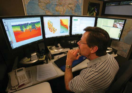

1 The Omega Seismic Processing System Seismic analysis at your fingertips

2 Omega is a flexible, scalable system that allows for processing and imaging on a single workstation up to massive compute clusters, or from a single 2D line to an immense 3D seismic survey. Our clients can experience Omega directly through licensed use of the software or through dedicated processing facilities in their offices. The Omega* seismic processing system from WesternGeco is unequalled in the industry. No other software package offers the breadth and depth of capabilities for solving today s geophysical challenges. Omega is a flexible, scalable system that allows for processing and imaging on a single workstation or massive compute clusters, or from a single 2D line to an immense 3D seismic survey. Omega accurately and efficiently processes land, marine, and transition zone data time and depth data 2D, 3D, and 4D surveys isotropic and anisotropic (TTI and VTI) velocity fields multicomponent data reservoir- to basin-scale projects. In addition, Omega software developers are now producing plug-ins for the Petrel* E&P software platform using the Ocean* application development framework. The power of the Omega system lies in its four major components. Interactive desktop allows geophysicists to easily and intuitively manage seismic projects and data, build workflows, QC processing results, visualize and analyze data, and interactively generate statics and velocity solutions. Omega infrastructure allows geophysicists to concentrate on geophysics as a result of a database-driven project model, automated data management, job submission, and detailed history. Geophysical algorithms has a robust algorithm base (400+ algorithms) in three packages Foundation, Time, and Depth. Additional advanced algorithms are available, including Reverse-Time Migration (RTM), Adaptive Beam Migration (ABM), Gaussian Packet Migration (GPM), 3D GSMP* General Surface Multiple Prediction, and Extended Internal Multiple Prediction (XIMP). Omega Windows Desktop integrates the compute power of Omega with the Petrel software visualization canvas, providing new, powerful geophysical workflows. Omega Petrel integration is truly realized in the WesternGeco Seismic Velocity Modeling (SVM), Localized Seismic Imaging (LSI), and Prestack Seismic Interpretation (PSI) plug-ins for Petrel software.


3 The Omega project model allows for integration and data sharing among all desktop applications. The Omega System Infrastructure: Project Model The Omega system utilizes an Oracle database to store all project information. The Omega project model (OPM) controls interactions between Oracle and all other Omega applications, making data access very efficient. In this database-driven environment, where all applications are linked, a complete history of the processing project is recorded and is always accessible. Information requires inputting only once to be available to the entire system from any application. For example, gridding information can be entered once (in Project Manager, the Omega project organization tool) to be recognized and applied in other applications such as the Omega workflow building application, SeisFlow. OPM also allows multiple geophysicists in a true multiuser environment to work on the same survey and be productive with numerous processing jobs and hundreds of thousands of datasets at every step of the processing life cycle.


4 Job Analysis checks job statistics as processing jobs complete, allowing Omega to automate QC tasks. Triggers automate job submission when given criteria are met, including the approval of job run statistics and plot QCs. The Omega Project Manager, Stage Jobs Viewer, and Job Monitor allow for tracking and monitoring of processing work on surveys of any size. Project Management The Omega Project Manager application allows the geophysicist to define the project hierarchy, i.e., the organizational structure of the seismic processing project. Seismic surveys can be divided into different processing steps (e.g., demultiple, velocity analysis) or different vintages in 4D acquisition. A processing workflow can be easily laid out so that the organizational structure of the work to be performed is clear to all participants. This processing hierarchy, or sequence, is displayed in the Project Manager application where individual jobs are displayed along with any ancillary data. Additional production management tools include Stage Jobs Viewer, Job Monitor, and Multi-Job Monitor. These allow for the easy monitoring of processing workflows at various levels of detail. The prior usage of any dataset can be quickly tracked using the Dataset History tool, which allows a geophysicist to rapidly understand workflows, algorithm parameters, and velocities that have been used to process a seismic dataset. Automation The Omega system is highly automated at both the infrastructure and the desktop levels. Routine tasks such as data management, job submission, and QC are easily automated, allowing the geophysicist to concentrate on geophysics. Nearly all data management tasks, such as selecting seismic files, outputting data to disk, load-balancing disks, and archiving and retrieving data from tape, can be handled automatically by the Omega resource data model (RDM). Additional automation tools increase geophysicist productivity when managing a project. Tools such as Job Analysis (to check job run statistics), Triggering (automated job submission based on given criteria), and QC sessions in SeisView* software increase throughput during production processing, allowing for detailed QC on even the largest projects. A robust batch production processing system for bulk processing includes all the tools necessary to schedule and manage large job queues. A geophysicist can quickly submit hundreds or thousands of separate jobs to the batch queue with just a few mouse clicks. The batch production processing system allows for parallelization in two forms: explicitly parallelized algorithms (mainly migration algorithms), and the ability to subdivide a survey and dispatch the data to multiple compute nodes within a cluster. This same system is in daily use at WesternGeco processing centers worldwide and allows WesternGeco to process huge volumes of seismic data efficiently and accurately.

5 SeisFlow allows the graphical building of the complex workflows needed for today s geophysical challenges. Workflow Building Omega allows for the intuitive creation of processing workflows with its graphical workflow builder, SeisFlow. Processing workflows are created interactively by selecting and inserting one of 400+ algorithms into the SeisFlow canvas. Each algorithm within Omega is graphically parameterized and contains detailed help documentation for each parameter setting, as well as details of the geophysics behind each algorithm. SeisFlow allows for the construction of a wide range of processing workflows, from simple data input or scaling to extremely complex 3D demultiple or depth migrations. Omega processing workflows can be submitted to a Linux compute node in three ways: (1) batch, submitted to a Linux cluster; (2) immediate, submitted to a targeted compute node; or (3) interactive, submitted to a targeted compute node but with the results displayed in SeisView software on the user s workstation without creating an output dataset. Batch submission is commonly used for production processing or parameter testing on complex processing workflows, whereas immediate or interactive submissions are mostly used for parameter testing because of their quick turnaround time.
 an attribute canvas.")
, including spectral analysis, autocorrelation, BP filtering, FK and")
 and")
6 Omega SeisView geoscience and engineering software is a 2D canvas that gives the geophysicist the tools to analyze and compare seismic data. Analyzing Seismic Data Omega has multiple applications to analyze seismic data, including SeisView software a 2D seismic canvas and Multiple Attribute Display (MAD) an attribute canvas. The SeisView software offers a robust 2D canvas for viewing full 32-bit seismic data and true random access, along with graphing and access to trace headers. Data analysis and investigation can be done using a series of interactive SeisView software toolkits (based on Omega algorithms), including spectral analysis, autocorrelation, BP filtering, FK and Tau-P filtering, noise attenuation, muting, and attribute generation. SeisView software can rapidly compare datasets using roll and flip displays, on-the-fly difference plots, linkages between datasets (prestack-to-prestack, prestack-to-stack, and stack-ato-stack) and corendering of displays. MAD is the Omega QA/QC analysis tool that allows a geophysicist to either interactively view a dataset s attributes, or view, in real time, attributes generated from multiple production processing workflows on the batch production system. MAD can be easily linked to SeisView software to create an attribute analysis workflow, in which attributes are selected in MAD and the seismic data are visualized in SeisView. Omega Packages Foundation basic QA/QC package includes all Omega infrastructure components and desktop applications plus algorithms for input/output and basic QC and analysis. Time most versatile package built on top of the foundation package. Includes a wide array of geophysical algorithms that allow for signal processing, geometry and statics, velocity analysis and picking, demultiple work, multicomponent processing, and time migrations. Time package allows for pre- and poststack 2D and 3D migrations, including Kirchhoff, finite difference, and Stolt algorithms. Depth enhances the time package by adding algorithms that allow for pre- and poststack depth migrations (isotropic [TTI] and anisotropic [VTI] velocity models), including Kirchhoff and wavefield extrapolation methods and the support for CIP tomography. Depth package requires the WesternGeco Seismic Velocity Modeling plug-in.


7 Omega system plug-ins enhance seismic processing through advanced algorithms, including high-end demultiple and migration techniques. One example is adaptive beam depth migration. Omega is extremely scalable in terms of both algorithms and compute capability. Multiple packages are available for varying geophysical challenges, including foundation, time and depth, and advanced algorithms. Windows Desktop Omega is optionally available with an interactive Windows - based desktop, while retaining the scalability and computational power of a Linux cluster architecture. The Omega Windows Desktop is available for license and preserves all the features, applications, and algorithms of the Linux version, but takes advantage of the power and flexibility of Windows. This option allows for integration with Seismic Velocity Modeling (SVM) from WesternGeco an advanced interactive velocity model building and depth migration Ocean platform plug-in. Omega Windows Desktop and its integration with SVM offers a seamless processing workflow from initial data preprocessing (geometry, noise attenuation, demultiple) through advanced depth imaging on one platform. Advanced Algorithms Several additional advanced algorithm packages can be licensed to run on the Omega system. 3D GSMP General Surface Multiple Prediction a full 3D SRME (surface-related multiple elimination) that accurately predicts complex multiples, including diffracted and scattered multiple energy XIMP (Extended Interbed Multiple Prediction) a data-driven demultiple algorithm that attenuates interbed multiples RTM (Reverse-Time Migration) high-end prestack two-way wave equation migration for accurate imaging in and below areas with great structural and velocity complexity GPM (Gaussian Packet Migration) full image gather output depth migration that allows for high resolution of steep dip images in complex environments and high-frequency images in postsalt targets ABM (Adaptive Beam Migration) high-end, full Gaussian beam migration for situations demanding outstanding image quality and high interpretation confidence Omega Research and Development The WesternGeco commitment to research and development ensures that the Omega system benefits from the latest geophysical processing technology, with regular updates and the availability of global expertise and support. A robust Omega Software Developers Kit (SDK) is available.


8 The Omega Seismic Processing System The Omega seismic processing system from WesternGeco is unequalled in the industry. No other software package offers the breadth and depth of capabilities for solving today s geophysical challenges. For more information, please contact wgsoftwaresales@slb.com. *Mark of Schlumberger Other company, product, and service names are the properties of their respective owners. Copyright 2012 Schlumberger. All rights reserved. 12-WGS-0014
VISTA. Desktop seismic data processing software
 VISTA Desktop seismic data processing software VERSION 2017 VISTA desktop seismic data processing software VISTA Desktop seismic data processing software Comprehensive seismic processing and QC software
D ATA P R O C E S S I N G S E R V I C E S. S e i s U P S O F T W A R E & D E V E L O P M E N T
 D ATA P R O C E S S I N G S E R V I C E S S e i s U P S O F T W A R E & D E V E L O P M E N T GeoCenter LP provides the latest in seismic data processing services and technology to the oil and gas industry.
EarthStudy 360. Full-Azimuth Angle Domain Imaging and Analysis
 EarthStudy 360 Full-Azimuth Angle Domain Imaging and Analysis 1 EarthStudy 360 A New World of Information for Geoscientists Expanding the Frontiers of Subsurface Exploration Paradigm EarthStudy 360 is
DUG HAS EXTENSIVE EXPERIENCE WITH COMPLEX DEPTH IMAGING PROJECTS FROM ALL MAJOR OIL AND GAS PRECINCTS
 DEPTH IMAGING DUG HAS EXTENSIVE EXPERIENCE WITH COMPLEX DEPTH IMAGING PROJECTS FROM ALL MAJOR OIL AND GAS PRECINCTS This combined experience, along with our advanced toolkit, means that we are ready and
Tu STZ1 06 Looking Beyond Surface Multiple Predictions - A Demultiple Workflow for the Culzean High Density OBC Survey
 Tu STZ1 06 Looking Beyond Surface Multiple Predictions - A Demultiple Workflow for the Culzean High Density OBC Survey S. Gupta (Schlumberger), A. Merry (Maersk Oil), L.P. Jensen (Maersk Oil), A. Clarke
Y015 Complementary Data-driven Methods for Interbed Demultiple of Land Data
 Y015 Complementary Data-driven Methods for Interbed Demultiple of Land Data S. Sonika* (WesternGeco), A. Zarkhidze (WesternGeco), J. Heim (WesternGeco) & B. Dragoset (WesternGeco) SUMMARY Interbed multiples
A case study for salt model building using CFP full azimuth data W. Gao*, Z. Guo, M. Guo, Q. Zhang, S. Hightower, G. Cloudy Jr. and Z.
 case study for salt model building using CFP full azimuth data W. Gao*, Z. Guo, M. Guo, Q. Zhang, S. Hightower, G. Cloudy Jr. and Z. Li, TGS Summary We present a case study of the salt model building for
P071 Land Data Regularization and Interpolation Using Azimuth Moveout (AMO)
") P071 Land Data Regularization and Interpolation Using Azimuth Moveout (AMO) A.M. Popovici* (3DGeo Development Inc.), S. Crawley (3DGeo), D. Bevc (3DGeo) & D. Negut (Arcis Processing) SUMMARY Azimuth Moveout
P071 Land Data Regularization and Interpolation Using Azimuth Moveout (AMO) A.M. Popovici* (3DGeo Development Inc.), S. Crawley (3DGeo), D. Bevc (3DGeo) & D. Negut (Arcis Processing) SUMMARY Azimuth Moveout
SeisEarth. Multi-survey Regional to Prospect Interpretation
 SeisEarth Multi-survey Regional to Prospect Interpretation 1 SeisEarth Fast and accurate interpretation, from regional to reservoir We ve been experimenting with the newest version of SeisEarth for some
SeisSpace Software. SeisSpace enables the processor to be able focus on the science instead of being a glorified data manager.
 SeisSpace Software OVERVIEW Delivering large volumes of data quickly and accurately remains the hallmark of any seismic processing system. With intuitive analysis tools, state-of-the-art geophysical algorithms
Seismic Time Processing. The Basis for Modern Seismic Exploration
 The Future of E&P Seismic Time Processing The Basis for Modern Seismic Exploration Fusion is a leading provider of Seismic Processing for the oil and gas industry from field tapes through final migration.
GPU implementation of minimal dispersion recursive operators for reverse time migration
 GPU implementation of minimal dispersion recursive operators for reverse time migration Allon Bartana*, Dan Kosloff, Brandon Warnell, Chris Connor, Jeff Codd and David Kessler, SeismicCity Inc. Paulius
NORSAR-3D. Predict and Understand Seismic. Exploring the Earth. Find the answers with NORSAR-3D seismic ray-modelling
 Exploring the Earth NORSAR-3D Predict and Understand Seismic Is undershooting possible? Which is the best survey geometry? MAZ, WAZ, RAZ, Coil, OBS? Why are there shadow zones? Can they be illuminated?
PGS hyperbeam - rapid scenario-testing of velocity models to optimize depth imaging
 A Publication of Petroleum Geo-Services Vol. 10 No. 4 April 2010 PGS hyperbeam - rapid scenario-testing of velocity models to optimize depth imaging Introduction Depth imaging is now established as a key
ABOUT GEOSEISMOS BACKGROUND AND HISTORY CLIENTS (BY GEOPROCESADOS)
") ABOUT GEOSEISMOS (BY GEOPROCESADOS) Geoseismos combines experience, quality and customized workflows from a specialized processing center with competitive prices and advanced technologies like the leading
ABOUT GEOSEISMOS (BY GEOPROCESADOS) Geoseismos combines experience, quality and customized workflows from a specialized processing center with competitive prices and advanced technologies like the leading
Introduction. Surface and Interbed Multtple Elimination
 Pre-stack Land Surface and Interbed Demultiple Methodology An Example from the Arabian Peninsula Roald van Borselen, Grog Fookes, Michel Schonewille, Constantine Tsingas, Michael West PGS Geophysical;
GeoDepth. Velocity Determination, Modeling and Imaging
 1 GeoDepth Velocity Determination, Modeling and Imaging 1 GeoDepth An Integrated System for Highest Quality Imaging in Depth Depth image with salt domes A Comprehensive System for Improved Seismic Imaging
Challenges of pre-salt imaging in Brazil s Santos Basin: A case study on a variable-depth streamer data set Summary
 Challenges of pre-salt imaging in Brazil s Santos Basin: A case study on a variable-depth streamer data set Jeremy Langlois, Bing Bai, and Yan Huang (CGGVeritas) Summary Recent offshore discoveries in
G012 Scattered Ground-roll Attenuation for 2D Land Data Using Seismic Interferometry
 G012 Scattered Ground-roll Attenuation for 2D Land Data Using Seismic Interferometry D.F. Halliday* (Schlumberger Cambridge Research), P.J. Bilsby (WesternGeco), J. Quigley (WesternGeco) & E. Kragh (Schlumberger
Examples of GLOBE Claritas Processing
 V6.0 Examples of GLOBE Claritas Processing Refraction Statics Removal of Noise (Land, 3D) Removal of Swell Noise Interpolation : shots/receivers Interpolation : 5D (STITCH) Demultiple : High Resolution
Reflection Seismic Processing
 Reflection Seismic Processing Objective Processing Systems General concept of CMP processing Processing Tools SEGY and similar file formats General features of ProMAX Reading: ProMAX manual (Introduction)
GeoProbe Geophysical Interpretation Software
 DATA SHEET GeoProbe Geophysical Interpretation Software overview DecisionSpace Geosciences key features Integrated building, editing and interactive deformation of sealed multi-z bodies extracted from
Attenuation of water-layer-related multiples Clement Kostov*, Richard Bisley, Ian Moore, Gary Wool, Mohamed Hegazy, Glenn Miers, Schlumberger
 Clement Kostov*, Richard Bisley, Ian Moore, Gary Wool, Mohamed Hegazy, Glenn Miers, Schlumberger Summary We present a method for modeling and separation of waterlayer-related multiples in towed streamer
Azimuth Moveout (AMO) for data regularization and interpolation. Application to shallow resource plays in Western Canada
 for data regularization and interpolation. Application to shallow resource plays in Western Canada") Azimuth Moveout (AMO) for data regularization and interpolation. Application to shallow resource plays in Western Canada Dan Negut, Samo Cilensek, Arcis Processing, Alexander M. Popovici, Sean Crawley,
Azimuth Moveout (AMO) for data regularization and interpolation. Application to shallow resource plays in Western Canada Dan Negut, Samo Cilensek, Arcis Processing, Alexander M. Popovici, Sean Crawley,
E044 Ray-based Tomography for Q Estimation and Q Compensation in Complex Media
 E044 Ray-based Tomography for Q Estimation and Q Compensation in Complex Media M. Cavalca* (WesternGeco), I. Moore (WesternGeco), L. Zhang (WesternGeco), S.L. Ng (WesternGeco), R.P. Fletcher (WesternGeco)
It is widely considered that, in regions with significant
 Multifocusing-based multiple attenuation Alex Berkovitch and Kostya Deev, Geomage Evgeny Landa, OPERA It is widely considered that, in regions with significant geologic complexity, methods which work directly
P. Bilsby (WesternGeco), D.F. Halliday* (Schlumberger Cambridge Research) & L.R. West (WesternGeco)
, D.F. Halliday* (Schlumberger Cambridge Research) & L.R. West (WesternGeco)") I040 Case Study - Residual Scattered Noise Attenuation for 3D Land Seismic Data P. Bilsby (WesternGeco), D.F. Halliday* (Schlumberger Cambridge Research) & L.R. West (WesternGeco) SUMMARY We show that
I040 Case Study - Residual Scattered Noise Attenuation for 3D Land Seismic Data P. Bilsby (WesternGeco), D.F. Halliday* (Schlumberger Cambridge Research) & L.R. West (WesternGeco) SUMMARY We show that
SEG Houston 2009 International Exposition and Annual Meeting
 Wave-equation based residual multiple prediction and elimination in migration depth domain as an aid to seismic interpretation in Wang, Manhong Guo, huck Mason, Jun ai, Sampath Gajawada, and Duryodhan
Modeling in Seismic. Tesseral Geo Modeling. Capability to compute 2D-2C and 3D- 3C gathers Enables Geo-scientists to make:
 www.tesseral-geo.com Multiparameter Numerical Medium for Seismic Modeling, Planning, Imaging & Interpretation Worldwide Tesseral Geo Modeling Modeling in Seismic Ray-tracing, and especially, finite-difference
AASPI SOFTWARE PARALLELIZATION
 AASPI SOFTWARE PARALLELIZATION Introduction Generation of multitrace and multispectral seismic attributes can be computationally intensive. For example, each input seismic trace may generate 50 or more
What s New and Where to Find It in V6.8
 What s New and Where to Find It in V6.8 Q4 2017 V6.8 At A Glance (Jan 2018) New SPSTAT2 module is simpler & easier to use, no specialized sort required, has inbuilt AGC and noise attenuation capability.
Main Menu. providing relatively fast and extremely high-quality and high-resolution performance.
 Full-Aimuth Angle Domain Imaging Zvi Koren, Igor Ravve, Evgeny Ragoa, Allon Bartana, Paradigm Geophysical, Dan Kosloff, Tel Aviv University and Paradigm Geophysical Summary This work presents a new seismic
Summary. Introduction. Multiple Attenuation
 Effective Multiple Attenuation and Depth Imaging with Thousands Well Ties for Montney Reservoir Characterization: A Western Canada Wembley Valhalla Land Case Study Hui Zhang, Dmitri Skorinski, Patty Evans,
We ELI1 02 Evaluating Ocean-bottom Seismic Acquisition in the North Sea - A Phased Survey Design Case Study
 We ELI1 02 Evaluating Ocean-bottom Seismic Acquisition in the North Sea - A Phased Survey Design Case Study M. Branston* (Schlumberger Geosolutions), R. Campbell (Schlumberger Geosolutions), M. Rowlands
Planning Land 3-D Seismic Surveys
 Planning Land 3-D Seismic Surveys Andreas Cordsen, Mike Galbraith, and John Peirce Edited by Bob A. Hardage Series Editor: Stephen J. Hill Geophysical Developments Series No. 9 Society of Exploration Geophysicists
Practical implementation of SRME for land multiple attenuation
 Practical implementation of SRME for land multiple attenuation Juefu Wang* and Shaowu Wang, CGGVeritas, Calgary, Canada juefu.wang@cggveritas.com Summary We present a practical implementation of Surface
SEG Houston 2009 International Exposition and Annual Meeting. paper are the work of TGS-Nopec on a subset of the Freedom WAZ data.
 Freedom Wide-zimuth Processing and Imaging, a case history study of WZ imaging in Mississippi Canyon, Gulf of Mexico Simon aldock*, Roy Camp, James Cai, in Wang and Xuening Ma, TGS-Nopec Geophysical Company
Th Towards Improved Time-lapse Seismic Repetition Accuracy by Use of Multimeasurement Streamer Reconstruction
 Th-11-02 Towards Improved Time-lapse Seismic Repetition Accuracy by Use of Multimeasurement Streamer Reconstruction P.J. Smith* (WesternGeco), J. Thekkekara (WesternGeco), G. Byerley (Apache North Sea
Obstacles in the analysis of azimuth information from prestack seismic data Anat Canning* and Alex Malkin, Paradigm.
 Obstacles in the analysis of azimuth information from prestack seismic data Anat Canning* and Alex Malkin, Paradigm. Summary The azimuth information derived from prestack seismic data at target layers
FIND YOUR GEO SOLUTION DOWNUNDER
 FIND YOUR GEO SOLUTION DOWNUNDER WHERE IT ALL BEGAN Meet our company founders. They started DUG in the back shed and turned it into a global service company. DownUnder GeoSolutions (DUG) was incorporated
Internal Multiple Attenuation on Radial Gathers With Inverse- Scattering Series Prediction
 Internal Multiple Attenuation on Radial Gathers With Inverse- Scattering Series Prediction Frederico Xavier de Melo, Clément Kostov, James Wu Schlumberger Summary We present a novel workflow for pre-stack
Shot-based pre-processing solutions for wide azimuth towed streamer datasets
 first break volume 25, March 2007 focus on azimuth Shot-based pre-processing solutions for wide azimuth towed streamer datasets Philippe Herrmann, 1* Gordon Poole, 2 Antonio Pica, 1 Sylvain Le Roy, 1 and
G009 Multi-dimensional Coherency Driven Denoising of Irregular Data
 G009 Multi-dimensional Coherency Driven Denoising of Irregular Data G. Poole* (CGGVeritas Services (UK) Ltd) SUMMARY Many land and ocean bottom datasets suffer from high levels of noise which make the
M. Warner* (S-Cube), T. Nangoo (S-Cube), A. Umpleby (S-Cube), N. Shah (S-Cube), G. Yao (S-Cube)
, T. Nangoo (S-Cube), A. Umpleby (S-Cube), N. Shah (S-Cube), G. Yao (S-Cube)") Tu A12 15 High-Resolution Reflection FWI M. Warner* (S-Cube), T. Nangoo (S-Cube), A. Umpleby (S-Cube), N. Shah (S-Cube), G. Yao (S-Cube) Summary We demonstrate reflection FWI on a less-than-ideal 3D narrow-azimuth
Tu A12 15 High-Resolution Reflection FWI M. Warner* (S-Cube), T. Nangoo (S-Cube), A. Umpleby (S-Cube), N. Shah (S-Cube), G. Yao (S-Cube) Summary We demonstrate reflection FWI on a less-than-ideal 3D narrow-azimuth
MiVu. Microseismic Processing System SURVEY DESIGN SIGNAL PROCESSING EVENT LOCATION VISUALIZATION.
 MiVu Microseismic Processing System SURVEY DESIGN SIGNAL PROCESSING EVENT LOCATION VISUALIZATION MiVuTM Microseismic Processing System MiVuTM is a software package designed to perform microseismic monitoring
Selection of an optimised multiple attenuation scheme for a west coast of India data set
 P-391 Selection of an optimised multiple attenuation scheme for a west coast of India data set Summary R Pathak*, PC Kalita, CPS Rana, Dr. S. Viswanathan, ONGC In recent years a number of new algorithms
2011 SEG SEG San Antonio 2011 Annual Meeting 3938
 Depth imaging Coil data: Multi azimuthal tomography earth model building and depth imaging the full azimuth Tulip coil project Michele Buia 1, Peter Brown 2, Bakhrudin Mansyur 2, Michelle Tham 3, Suyang
Controlled stacking for improved quality of prestack depth-migration results
 CORNER INTERPRETER S Controlled stacking for improved quality of prestack depth-migration results DAVID KESSLER, CGG American Services, Houston, Texas LUIS CANALES and CHUNG-CHI SHIH, CogniSeis Development,
We LHR5 06 Multi-dimensional Seismic Data Decomposition for Improved Diffraction Imaging and High Resolution Interpretation
 We LHR5 06 Multi-dimensional Seismic Data Decomposition for Improved Diffraction Imaging and High Resolution Interpretation G. Yelin (Paradigm), B. de Ribet* (Paradigm), Y. Serfaty (Paradigm) & D. Chase
CLASSIFICATION OF MULTIPLES
 Introduction Subsurface images provided by the seismic reflection method are the single most important tool used in oil and gas exploration. Almost exclusively, our conceptual model of the seismic reflection
Tu N Internal Multiple Attenuation on Radial Gathers With Inverse-scattering Series Prediction
 Tu N114 05 Internal Multiple Attenuation on Radial Gathers With Inverse-scattering Series Prediction F. Xavier de Melo* (Schlumberger), C. Kostov (Schlumberger) & J. Wu (Schlumberger) SUMMARY We present
TomoXPro. Crosshole Survey Design, Modeling, Data Processing, Tomography, and Migration
 TomoXPro Crosshole Survey Design, Modeling, Data Processing, Tomography, and Migration TomoXPro Complete Crosshole Seismic Application Crosshole survey design for complex geology Synthetic and wavefield
Seismic Data Preconditioning for Improved Reservoir Characterization (Inversion and Fracture Analysis)
") Seismic Data Preconditioning for Improved Reservoir Characterization (Inversion and Fracture Analysis) Darren Schmidt *, Hampson-Russell, Calgary, AB, Canada Darren.Schmidt@cggveritas.com Alicia Veronesi,
Seismic Data Preconditioning for Improved Reservoir Characterization (Inversion and Fracture Analysis) Darren Schmidt *, Hampson-Russell, Calgary, AB, Canada Darren.Schmidt@cggveritas.com Alicia Veronesi,
3-D vertical cable processing using EOM
 Carlos Rodriguez-Suarez, John C. Bancroft, Yong Xu and Robert R. Stewart ABSTRACT Three-dimensional seismic data using vertical cables was modeled and processed using equivalent offset migration (EOM),
Inversion after depth imaging
 Robin P. Fletcher *, Stewart Archer, Dave Nichols, and Weijian Mao, WesternGeco Summary In many areas, depth imaging of seismic data is required to construct an accurate view of the reservoir structure.
Geogiga Seismic Pro 8.0 Release Notes
 Geogiga Seismic Pro 8.0 Release Notes Copyright 2015, All rights reserved. Table of Contents Introduction...1 Part 1 General Enhancements...3 Trace Display...4 Color Section Display...6 Curve Plotting...8
Refraction Full-waveform Inversion in a Shallow Water Environment
 Refraction Full-waveform Inversion in a Shallow Water Environment Z. Zou* (PGS), J. Ramos-Martínez (PGS), S. Kelly (PGS), G. Ronholt (PGS), L.T. Langlo (PGS), A. Valenciano Mavilio (PGS), N. Chemingui
Seismic Modeling, Migration and Velocity Inversion
 Seismic Modeling, Migration and Velocity Inversion Aliasing Bee Bednar Panorama Technologies, Inc. 14811 St Marys Lane, Suite 150 Houston TX 77079 May 16, 2014 Bee Bednar (Panorama Technologies) Seismic
A Novel 3-D De-multiple Workflow for Shallow Water Environments - a Case Study from the Brage field, North Sea
 A Novel 3-D De-multiple Workflow for Shallow Water Environments - a Case Study from the Brage field, North Sea J. Oukili* (PGS), T. Jokisch (PGS), A. Pankov (PGS), B. Farmani (PGS), G. Ronhølt (PGS), Ø.
Lab 3: Depth imaging using Reverse Time Migration
 Due Wednesday, May 1, 2013 TA: Yunyue (Elita) Li Lab 3: Depth imaging using Reverse Time Migration Your Name: Anne of Cleves ABSTRACT In this exercise you will familiarize yourself with full wave-equation
Writing Kirchhoff migration/modelling in a matrix form
 Writing Kirchhoff migration/modelling in a matrix form Abdolnaser Yousefzadeh and John C. Bancroft Kirchhoff migration matrix ABSTRACT Kirchhoff prestack migration and modelling are linear operators. Therefore,
Migration from a non-flat datum via reverse-time extrapolation
 Stanford Exploration Project, Report 84, May 9, 2001, pages 1 50 Migration from a non-flat datum via reverse-time extrapolation Gopal Palacharla 1 ABSTRACT Land surveys usually have elevation changes,
PSPRO AZIMUTHAL. Big Data Software for Interactive Analysis and Interpretation of Full-Azimuth Seismic Gathers. Power to Decide
 Power to Decide PSPRO AZIMUTHAL Big Data Software for Interactive Analysis and Interpretation of Full-Azimuth Seismic Gathers Full-Azi Horizon Tracking Dynamic Sectoring COV/COCA Data Input Interactive
G021 Subsalt Velocity Analysis Using One-Way Wave Equation Based Poststack Modeling
 G021 Subsalt Velocity Analysis Using One-Way Wave Equation Based Poststack Modeling B. Wang* (CGG Americas Inc.), F. Qin (CGG Americas Inc.), F. Audebert (CGG Americas Inc.) & V. Dirks (CGG Americas Inc.)
Angle Gathers for Gaussian Beam Depth Migration
 Angle Gathers for Gaussian Beam Depth Migration Samuel Gray* Veritas DGC Inc, Calgary, Alberta, Canada Sam Gray@veritasdgc.com Abstract Summary Migrated common-image-gathers (CIG s) are of central importance
Postmigration multiple prediction and removal in the depth domain
 GEOPHYSICS. VOL. 76, NO. 5 (SEPTEMBER-OCTOBER 2011); P. WB217 WB223, 10 FIGS. 10.1190/GEO2011-0010.1 Postmigration multiple prediction and removal in the depth domain Bin Wang 1, Jun Cai 1, Manhong Guo
EARTH SCIENCES RESEARCH JOURNAL
 EARTH SCIENCES RESEARCH JOURNAL Earth Sci. Res. J. Vol. 10, No. 2 (December 2006): 117-129 ATTENUATION OF DIFFRACTED MULTIPLES WITH AN APEX-SHIFTED TANGENT- SQUARED RADON TRANSFORM IN IMAGE SPACE Gabriel
Predicting rugged water-bottom multiples through wavefield extrapolation with rejection and injection
 Predicting rugged water-bottom multiples through wavefield extrapolation with rejection and injection Benxi Ke ABSTRACT Although convolution-based and WEM-modeling-based methods for predicting surface-related
IMAGING USING MULTI-ARRIVALS: GAUSSIAN BEAMS OR MULTI-ARRIVAL KIRCHHOFF?
 IMAGING USING MULTI-ARRIVALS: GAUSSIAN BEAMS OR MULTI-ARRIVAL KIRCHHOFF? Summary Samuel H. Gray* Veritas DGC Inc., 715 Fifth Ave. SW, Suite 2200, Calgary, AB Sam_gray@veritasdgc.com Carl Notfors Veritas
PLEASE NOTE THAT THERE ARE QUESTIONS IN SOME OF THESE SECTIONS THAT ARE TO BE TURNED IN AS HOMEWORK.
 Seismic Reflection Lab for Geology 594 BEFORE YOU DO ANYTHING INSERT THE DONGLE ON THE LEFT SIDE OF THE KEYBOARD (LIGHT SIDE UP). The little green light will come on showing the dongle is activated. You
G017 Beyond WAZ - A Modeling-based Evaluation of Extensions to Current Wide Azimuth Streamer Acquisition Geometries
 G017 Beyond WAZ - A Modeling-based Evaluation of Extensions to Current Wide Azimuth Streamer Acquisition Geometries M. Cvetkovic* (ION Geophysical), Z. Zhou (ION Geophysical / GXT Imaging Solutions) &
Multicomponent wide-azimuth seismic data for defining fractured reservoirs
 Multicomponent wide-azimuth seismic data for defining fractured reservoirs Evaluating and exploiting azimuthal anisotropy Data Processing Figure 1 A typical surface outcrop showing aligned fractures Figure
Anatomy of common scatterpoint (CSP) gathers formed during equivalent offset prestack migration (EOM)
 gathers formed during equivalent offset prestack migration (EOM)") Anatomy of CSP gathers Anatomy of common scatterpoint (CSP) gathers formed during equivalent offset prestack migration (EOM) John C. Bancroft and Hugh D. Geiger SUMMARY The equivalent offset method of
Anatomy of CSP gathers Anatomy of common scatterpoint (CSP) gathers formed during equivalent offset prestack migration (EOM) John C. Bancroft and Hugh D. Geiger SUMMARY The equivalent offset method of
Common-angle processing using reflection angle computed by kinematic pre-stack time demigration
 Common-angle processing using reflection angle computed by kinematic pre-stack time demigration Didier Lecerf*, Philippe Herrmann, Gilles Lambaré, Jean-Paul Tourré and Sylvian Legleut, CGGVeritas Summary
Investigation of deep-water Gulf of Mexico subsalt imaging using anisotropic model, data set and RTM Tempest
 GEOPHYSICS. VOL. 76, NO. 5 (SEPTEMBER-OCTOBER 2011); P. WB21 WB26, 12 FIGS. 10.1190/GEO2011-0043.1 Investigation of deep-water Gulf of Mexico subsalt imaging using anisotropic model, data set and RTM Tempest
We Survey Design and Modeling Framework for Towed Multimeasurement Seismic Streamer Data
 We-04-12 Survey Design and Modeling Framework for Towed Multimeasurement Seismic Streamer Data K. Eggenberger* (Schlumberger), P. Christie (Schlumberger), M. Vassallo (Schlumberger) & D.J. van Manen (Schlumberger)
Missing trace interpolation and its enhancement of seismic processes
 Missing trace interpolation Missing trace interpolation and its enhancement of seismic processes Wai-kin Chan and Robert R. Stewart ABSTRACT Many multi-channel seismic algorithms assume that the input
2010 SEG SEG Denver 2010 Annual Meeting
 Localized anisotropic tomography with checkshot : Gulf of Mexico case study Andrey Bakulin*, Yangjun (Kevin) Liu, Olga Zdraveva, WesternGeco/Schlumberger Summary Borehole information must be used to build
High performance Computing and O&G Challenges
 High performance Computing and O&G Challenges 2 Seismic exploration challenges High Performance Computing and O&G challenges Worldwide Context Seismic,sub-surface imaging Computing Power needs Accelerating
AVO, migration apertures Fresnel zones, stacking, Q, anisotropy, and fast inversions
 AVO, migration apertures Fresnel zones, stacking, Q, anisotropy, and fast inversions John C. Bancroft and grad students University of Calgary CREWES 2003 NSERC 1 Grad students Shuang Sun Pavan Elapavuluri
Geogiga Seismic Pro 8.3 Release Notes
 Geogiga Seismic Pro 8.3 Release Notes Copyright 2017, All rights reserved. Table of Contents Introduction...1 Part 1 Utility Modules...2 Part 2 Reflection Modules...4 Updates in SF Imager...5 Updates in
Azimuthal binning for improved fracture delineation Gabriel Perez*, Kurt J. Marfurt and Susan Nissen
 Azimuthal binning for improved fracture delineation Gabriel Perez*, Kurt J. Marfurt and Susan issen Abstract We propose an alternate way to define azimuth binning in Kirchhoff prestack migration. This
Optimising 4D Seismic with Evolving Technology over 20 Years of Reservoir Monitoring of the Gullfaks Field, North Sea
 Optimising 4D Seismic with Evolving Technology over 20 Years of Reservoir Monitoring of the Gullfaks Field, North Sea D.J. Anderson* (PGS), M. Wierzchowska (PGS), J. Oukili (PGS), D. Eckert (Statoil ASA),
SEG/New Orleans 2006 Annual Meeting
 3-D tomographic updating with automatic volume-based picking Dimitri Bevc*, Moritz Fliedner, Joel VanderKwaak, 3DGeo Development Inc. Summary Whether refining seismic images to evaluate opportunities in
Introduction to the traveltime tomography and prestack migration for borehole-data within REFLEXW
 Introduction to the traveltime tomography and prestack migration for borehole-data within REFLEXW In the following the use of the traveltime tomography and the prestack-migration for different types of
WinGLink. Geophysical interpretation software VERSION
 WinGLink Geophysical interpretation software VERSION 2.21.08 WinGLink geophysical interpretation software WinGLink Geophysical interpretation software Essential tools for data QC, processing, and modeling
Tu A11 01 Seismic Re-processing and Q-FWI Model Building to Optimise AVO and Resolution in the Shallow Wisting Discovery
 Tu A11 01 Seismic Re-processing and Q-FWI Model Building to Optimise AVO and Resolution in the Shallow Wisting Discovery G. Apeland* (WesternGeco), P. Smith (WesternGeco), O. Lewis (WesternGeco), S. Way
We Solutions for Scattered Surface-wave Attenuation in the Western Desert of Egypt
 We-14-11 Solutions for Scattered Surface-wave Attenuation in the Western Desert of Egypt D. Yanchak* (Apache Corporation), D. Monk (Apache Corporation), A.V. Zarkhidze (WesternGeco), P. Blair (WesternGeco),
An illustration of adaptive Marchenko imaging
 An illustration of adaptive Marchenko imaging Joost van der Neut 1, Kees Wapenaar 1, Jan Thorbecke 1, Evert Slob 1, and Ivan Vasconcelos 2 Abstract In Marchenko imaging, wavefields are retrieved at specified
Anisotropic model building with well control Chaoguang Zhou*, Zijian Liu, N. D. Whitmore, and Samuel Brown, PGS
 Anisotropic model building with well control Chaoguang Zhou*, Zijian Liu, N. D. Whitmore, and Samuel Brown, PGS Summary Anisotropic depth model building using surface seismic data alone is non-unique and
Summary. Introduction
 Multivessel coil shooting acquisition with simultaneous sources Nick Moldoveanu¹, Ying Ji², Craig Beasley¹ ¹WesternGeco, ²Schlumberger Cambridge Research Summary Multivessel coil shooting is a towed-streamer
Crosswell Imaging by 2-D Prestack Wavepath Migration
 Crosswell Imaging by 2-D Prestack Wavepath Migration Hongchuan Sun ABSTRACT Prestack wavepath migration (WM) is applied to 2-D synthetic crosswell data, and the migrated images are compared to those from
G042 Subsalt Imaging Challenges - A Deepwater Imaging Analysis
 G042 Subsalt Imaging Challenges - A Deepwater Imaging Analysis M. Cogan* (WesternGeco), J. Gardner (WesternGeco) & N. Moldoveanu (WesternGeco) SUMMARY Upon completion of the final reverse-time migration
Tu-P05-05 Multi-azimuth Anisotropic Tomography and PreSDM of a North Sea Streamer Survey
 Tu-P05-05 Multi-azimuth Anisotropic Tomography and PreSDM of a North Sea Streamer Survey D. Sekulic* (ION Geophysical), O. Matveenko (Total E&P Norge), J.K. Fruehn (ION GXT) & G. Mikkelsen (Total E&P Norge)
H003 Deriving 3D Q Models from Surface Seismic Data Using Attenuated Traveltime Tomography
 H003 Deriving 3D Q Models from Surface Seismic Data Using Attenuated Traveltime Tomography M. Cavalca* (Schlumberger - Westerngeco) & R.P. Fletcher (Schlumberger - Westerngeco) SUMMARY Estimation of the
Borehole Seismic Services Data processing, imaging and dedicated expertise
 Borehole Seismic Services Data processing, imaging and dedicated expertise To reduce risk and optimize recovery, you need a clear picture of the reservoir. OptaSense Borehole Seismic Services help you
Interactive Velocity Analysis (aaspi_iva): Program: Precompute Velocity Semblance, Interactive Velocity Analysis, Velocity Interpolation
: Program: Precompute Velocity Semblance, Interactive Velocity Analysis, Velocity Interpolation") Interactive Velocity Analysis (aaspi_iva): Program: Precompute Velocity Semblance, Interactive Velocity Analysis, Velocity Interpolation Computational Flowchart Time Migrated Prestack Gathers Post Stack
Interactive Velocity Analysis (aaspi_iva): Program: Precompute Velocity Semblance, Interactive Velocity Analysis, Velocity Interpolation Computational Flowchart Time Migrated Prestack Gathers Post Stack
Downloaded 05/09/13 to Redistribution subject to SEG license or copyright; see Terms of Use at
 Elastic converted-wave path migration for subsalt imaging Ru-Shan Wu*, Rui Yan, Xiao-Bi Xie, Modeling and Imaging Laboratory, Earth and Planetary Sciences/IGPP, University of California, Santa Cruz, David
Multiple attenuation for shallow-water surveys: Notes on old challenges and new opportunities
 Multiple attenuation for shallow-water surveys: Notes on old challenges and new opportunities Clement Kostov 1, Frederico Xavier de Melo 1, Abhishek Raj 1, Alexander Zarkhidze 1, Alex Cooke 1, Glenn Miers
P068 Case Study 4D Processing OBC versus Streamer Example of OFON filed, Block OML102, Nigeria
 P068 Case Study 4D Processing OBC versus Streamer Example of OFON filed, Block OML102, Nigeria T. Castex* (Total SA), P. Charrier (CGG), M.N. Dufrene (Total SA) & C. Orji (EPNL) SUMMARY This case study