THE EARTHS SURFACE IS CHANGING
|
|
|
- Kelley Stewart
- 5 years ago
- Views:
Transcription


1
2 THE EARTHS SURFACE IS CHANGING

3

4 Vertical Motion Associated with Subduction Hyndman and Wang, 1994


5 NATIONAL OCEANIC AND ATMOSPHERIC ADMINISTRATION National Ocean Service National Geodetic Survey Positioning America for the Future

6 Horizontal velocities in the western U.S. relative to the North American Datum of 1983 as derived from geodetic observations. -Times 8 years ( ) -As will be seen realized with NAD 83(2011)Epoch2010 (tent. name) Slide from R. Snay, NGS
7
8

9
10 THE PROJECT
11 CONUS Conterminous United States CORS Continuously Operating Reference Stations FGDC Federal Geographic Data Committee GNSS Global Navigation Satellite System GPS Global Positioning System HTDP Horizontal Time Dependent Positioning (NGS software) IGS International GNSS Service MYCS Multi-Year CORS Solution Epoch An epoch is a moment in time used as a reference point.
12 NA2011 National Adjustment of 2011 NAD 83 North American Datum of 1983 NAVD 88 North American Vertical Datum of 1988 NADCON North American Datum Conversion (NGS software) NGS National Geodetic Survey NGSIDB National Geodetic Survey Integrated Data Base OPUS Online Positioning User Service
 and High Accuracy Reference Network (HARN) realizations Most done in 1990s,")
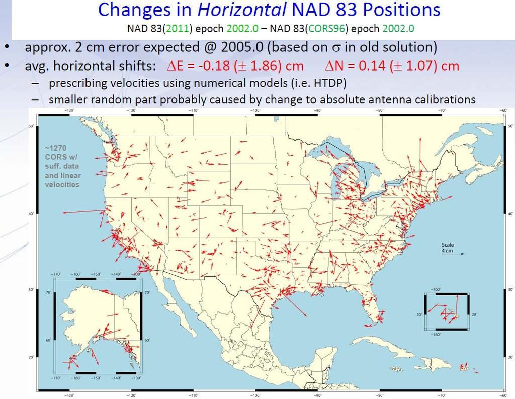
 and (NSRS2007) Simultaneous nationwide adjustment (GNSS only) New realization: NAD 83(2011)")
13 Original realization completed in 1986 Consisted (almost) entirely of classical (optical) observations High Precision Geodetic Network (HPGN) and High Accuracy Reference Network (HARN) realizations Most done in 1990s, essentially stateby-state Based on GNSS but classical stations included in adjustments National Re-Adjustment of 2007 NAD 83(CORS96) and (NSRS2007) Simultaneous nationwide adjustment (GNSS only) New realization: NAD 83(2011) epoch

")

14 Multi-Year CORS Solution (MYCS) Reprocessing of all CORS GPS data 1994-present 2264 CORS & global stations NAD 83 computed by transformation from IGS08 National Adjustment of 2011 (NA2011) New adjustment of GNSS passive control GNSS vectors tied (and constrained) to CORS NAD 83(2011) epoch Approximately 80,000 stations and 400,000 GNSS vectors Realization SAME for CORS and passive marks This is NOT a new datum! (still NAD 83)
15 The project is officially called the National Adjustment of 2011, abbreviated as NA2011. It is a nationwide, geometric adjustment of passive stations with positions determined using Global Navigation Satellite System (GNSS) technology and data, which includes the Global Positioning System (GPS).
16 NA2011 is called geometric because it will yield new values for latitude, longitude, and ellipsoid height; it will NOT affect the orthometric heights of stations. However, a future nationwide vertical adjustment is being considered to determine GNSSderived orthometric heights based on the results of NA2011
17 NAD 83(2011) epoch is datum tag year adjustment complete is epoch date (January 1, 2010) Date associated with coordinates of control station Frame fixed to North American tectonic plate Includes California, Puerto Rico, and US Virgin Islands NAD 83(PA11) epoch Frame fixed to Pacific tectonic plate NAD 83(MA11) epoch Frame fixed to Mariana tectonic plate


18 There has been no datum change, that is, the origin, scale and orientation of NAD 83(2011) are identical to those of NAD 83(CORS96). The changes in coordinates are driven by multiple factors including the switch to absolute antenna calibrations, new/revised processing algorithms, improved discontinuity identification, longer data sets, and our improved definition of the global reference frame. However for the end user the biggest change is caused by the new reference epoch, which has changed by 8 years from to

19
20 CORS
21 ITRF NAD83(CORS96) Relative antenna calibration ITRF2000, defined by only 8 global stations IGS08 (2011) NAD83(2011) Absolute ITRF2008 uses ~230 stations What does this all mean? Average differences of NAD 83(2011) epoch minus NAD 83(CORS96) epoch : East cm; North cm; Vertical cm Current Upcoming < 2 mm +/- 1-2 cm (nationally)
22 The National Geodetic Survey (NGS) operates the Continuously Operating Reference Station (CORS) Network that provides Global Navigation Satellite System (GNSS) data in RINEX format, and associated positions. Currently NGS provides these coordinates in ITRF00 epoch , and in NAD 83(CORS96) epoch NGS has completed a full reanalysis of all data from CORS and a set of global sites with the goal to compute a fully consistent set of coordinates, GPS satellite orbits and Earth Orientation Parameters (EOP). This initial Multi-Year CORS (MYCS1) effort is the first of a series reprocessing projects that will occur periodically in the coming years.

23 Slide by J. Griffiths and the MYCS Team

24

25 REGIONAL CORS NETWORK
26
27 NAD 83 CORS 96 VS NAD WASHINGTON NORTH ZONE US FEET NAD 83/CORS 96 US FT NAD US FT DIFFERENCE US FT NAME PID# NORTHING EASTING ELLIPSE NAME PID# NORTHING EASTING ELLIPSE NORTH EAST ELLIPSE BREW DK BREW DK CHWK DE CHWK DE CPXF AJ CPXF AJ CHZZ AJ CHZZ AJ FTS1 AF FTS1 AF FTS2 AF FTS2 AF FTS5 DK FTS5 DK FTS6 DK FTS6 DK GOBS AF GOBS AF GWEN AF GWEN AF GWN2 AF GWN2 AF GWN5 DJ GWN5 DJ GWN6 DJ GWN6 DJ KELS AF KELS AF LIND AH LIND AH LINH CQ LINH CQ LNGB DG NEAH AF NEAH AF
28 ORS1 DG ORS1 DG ORS2 DG ORS2 DG P020 DG P020 DG P376 DH P376 DH P415 DH P415 DH P420 DG P420 DG P432 DG P432 DG P446 DK P446 DK P451 DH P451 DH P687 DH P687 DH P690 DH P690 DH P693 DH P693 DH P695 DH P695 DH P696 DH P696 DH P697 DH P697 DH P698 DH P698 DH P699 DH P699 DH P702 DH P702 DH PABH AF PABH AF PRDY DF RPT1 AF RPT1 AF RPT2 AF RPT2 AF RPT5 DK RPT5 DK RPT6 DK RPT6 DK SC00 AJ SC00 AJ SEAI DH SEAI DH SEAT AF SEAT AF SEAW AH SEAW AH SEDR AF SEDR AF
29 SPN1 AJ SPN1 AJ SPN2 AJ SPN2 AJ SPN5 DK SPN5 DK SPN6 DK SPN6 DK THUN DF TWHL AJ TWHL AJ WHD1 AF WHD1 AF WHD2 AF WHD2 AF WHD5 DK WHD5 DK WHD6 DK WHD6 DK YELM DF ZSE1 DF ZSE1 DF


30 Why is NGS doing a national adjustment a mere 4 years after the last adjustment
31 How will it be done? longer data spans absolute antenna calibrations satellite transmitting and ground receiving antennas new network design added redundancy Delaunay triangulation over global sites and CORS backbone tie remaining CORS to backbone as stars IERS 2003 Conventions generally implemented updated model for station displacements due to ocean tidal loading updated models for troposphere propagation delays use current frame; first attempt to obtain a full history of products in a fully consistent framework. Contribute NGS reprocessed orbits, to International GNSS Service) Slide by J. Griffiths and the MYCS Team
32 In order for the coordinates of passive stations to maintain consistency with the CORS representation of the NSRS, NGS will be doing another national adjustment this year The datum tag that will be adopted for both CORS (active) and passive is NAD83(2011) CORS (only) will be the control for the LSA
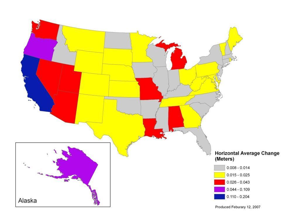
33 For NGS products and services to be mutually aligned, it is necessary to perform an adjustment (constrained to the new MYCS coordinates) of as many GNSS vectors held in the NGS Integrated Data Base (NGSIDB) as possible.
34 These vectors represent GNSS observations between passive stations, and, importantly, between passive stations and CORS (i.e., active stations). The vectors tied to CORS will make it possible to determine new coordinates on passive control that are consistent with the MYCS.
35 All CORS with GNSS data archived by NGS were included in the MYCS. The only CORS not included are those that have no archived data, which consists only of a small number of Cooperative CORS. Of these, the only ones excluded were decommissioned prior to becoming part of the NGS CORS network and did not provide their historic GNSS data to NGS. The Cooperative CORS program is no longer in effect, and so all currently operating CORS are simply CORS, and they are all included in the MYCS. A list of previously operating CORS that were not used in the MYCS will be provided in the near future.
36 NGS is in the process of readjusting most, if not all, of the passive vector control in the NGSIDB to make it consistent with MYCS1 solution. The results of this adjustment (National Readjustment of 2011) will have the same reference frame tag and epoch date as the MYCS1, namely NAD 83(2011) epoch
37 A passive station is, in NGS terminology, a conventional ground station, e.g., a brass disk set in a substantial structure, a steel rod driven vertically into the ground until refusal, or other such stable physical marks that can be occupied with survey equipment. An active station is a GNSS antenna (and associated receiver) in a fixed location providing GNSS data to the public, such as a CORS,WSRN
38 GNSS observations (vectors) for all passive control stations in the NGS Integrated Data Base (NGSIDB) connected (directly or indirectly) to CORS with MYCS coordinates as of July 31, 2011 may be included in the adjustment. However, being included in the adjustment only assures that the observations will be evaluated for their possible inclusion in the final adjustment. As with any survey control network adjustment, observations that do not fit well with other observation (i.e., outliers ) will be rejected. In some cases, this may result in passive control stations being excluded from NA2011, in which case they will retain their previous datum tag. Projects submitted after July 31, 2011 will be published with NAD 83(NSRS2007) coordinates until NA2011 is completed. At that time those projects in the queue will be adjusted to the new realization and published on NAD 83(2011) epoch
39 Any passive station that does not have acceptable GNSS data will be excluded from NA2011, as will stations that are not (directly or indirectly) connected to a CORS in the MYCS. For passive stations meeting these criteria, NGS intends to provide NAD 83(2011) epoch coordinates everywhere that is appropriate and can be determined accurately with respect to the MYCS. This will include the conterminous US (CONUS) and Alaska, and it may include other locations outside CONUS as well. The decision as to what additional areas to include will be made during the course of the project. Stations not included in NA2011 will continue to have their positions referenced to the same datum realization used for current survey control prior to NA2011 (as indicated by the datum tag on NGS datasheets).
40 The answer is entirely dependent upon whether an acceptable GNSS survey is ever performed at that passive control mark. For non-gnss (i.e., classically determined) control, the most accurate way to determine coordinates consistent with a modern realization of NAD 83 is to resurvey it using geodetic quality GNSS data. The intended use of this position will determine whether an OPUS solution is sufficient or if a complete GNSS survey submitted to NGS for publication is required.
 coordinates for all published passive control and NAD 83(CORS96) coordinates for all")
41 First, consult with NGS through the appropriate personnel or NGS headquarters personnel to ensure your project meets NGS requirements for projects performed during this time frame. When performing the constrained adjustments, unless advised differently by NGS personnel, hold NAD 83(NSRS2007) coordinates for all published passive control and NAD 83(CORS96) coordinates for all CORS in the survey. The same approach for constraining a survey should also be used for projects submitted to NGS that will be included in NA2011 (i.e., before the cut-off date).
")
42 Yes, those stations will have network and local accuracies computed and published along with the NAD 83(2011) epoch coordinates. As with the NA2011 project itself, these accuracies will be provided in centimeters, and at the 95% confidence level in accordance with the Federal Geographic Data Committee (FGDC) Geospatial Positioning Accuracy Standards, Part 2
43 Based on the MYCS results, the average expected change is about 2 cm horizontally and 1 cm vertically (i.e., ellipsoid height). However, these changes especially the horizontal changes vary significantly. In addition, the largest part of the horizontal change is due to time difference (velocity), especially in tectonically active areas, such as California; when brought to a common time ( ), the average horizontal change decreases to 0.2 cm. A list of coordinate changes, from NAD 83(NSRS2007) epoch to NAD 83(2011) epoch will be provided to the public.


44 For the purposes of transforming the official coordinates of each geodetic control point, NGS will not create a transformation model. An interpolative transformation tool, like NADCON, functions only to apply gross consistent regional shifts to entire areas. NGS will certainly examine the shifts in coordinates for such behavior, but the shifts in going to NAD 83(2011) from NAD 83(NSRS2007) are not expected to significantly exceed the formal errors of those shifts, nor are they expected to all move in one consistent direction regionally. NGS does not endorse the idea of applying a simple interpolative tool to all surveys and maps in a region, as they each will have their own unique connections to surrounding geodetic control. Although NGS will look at all possibilities, there is already compelling evidence that a singular transformed dataset will have very limited applications, and may actually be highly misleading. This is especially the case as the size of the area and required spatial accuracy increase.
45 Good agreement with IGS type means Pending approval from International GNSS Service (IGS) ION GNSS /23/
46 RESULTS


47 Diagram shows plots of average error for 5 points constrained for each of the three realizations. The MYCS coordinates fit the baselines observed much better than the other two.
48 OPUS-net info. From Dr. Neil Weston OPUS-Static U.S. CORS Network Fixed IGS ephemerides Computes independent double differenced baseline solutions between the unknown and 3 CORS Relative antenna models Phase ambiguity integer fixing Relative troposphere modeling ITRF2000 reference frame Average position solution Peak Peak error reported OPUS-Net U.S. CORS Network & IGS Global Network Network approach Consists of 3 nearby CORS + up to 12 CGPS from global IGS network Absolute antenna models SV & ground Ocean tidal loading model Satellite weighting Relative troposphere modeling ITRF2008 reference frame Weighted least squares adjustment Weighted mean and standard deviations reported at 95%
49 WHAT ABOUT THE WSRN?


50
51

52 HTDP v 3.1
53 The epoch is the date associated with the coordinates of a control station. An epoch is a necessary part of a complete datum or reference frame name because coordinates can change with time (i.e., they may have non-zero velocities relative to some chosen, stable coordinate reference). For NA2011, the positions will be referenced to midnight January 1 of 2010 (epoch ). NGS has provided epoch dates for CORS and related products (such as OPUS) for many years, and for passive marks included in the 2007 national readjustment. This practice will continue for NA2011, and it will become more prevalent and consistent throughout NGS. Typically the epoch date is displayed with two decimal places. Users should be aware that if the velocity of a station is known, then its position can be computed at different epochs; thus one datum tag can have multiple epochs. However, the accuracy of the computed position will depend on the accuracy of the velocity, which varies by station and location. Epoch dates on some stations may also change without changing the datum tag if a local episodic event (such as an earthquake) occurs that requires a local adjustment to determine new positions. In summary, epoch dates are needed to accommodate the precision of GNSS measurements and to recognize the dynamic nature of the Earth and its effect on coordinates.
 or")
54 Interactively estimate displacements between two dates. Individual points entered interactively or Points on a specified grid Select NAD83(CORS96) or NAD83(NSRS2007) Select the dot for Deci-year format
55

56
57 GRAVITY - GEOID12
58 New hybrid geoid model (likely GEOID12 ) Use NAD 83(2011) epoch ellipsoid heights on NAVD 88 benchmarks Might also use OPUS-Database results on NAVD 88 BMs May perform national vertical adjustment Constrain vertically to NAVD 88 benchmarks Perform as simultaneous nationwide adjustment GNSS-derived orthometric heights NAD 83(2011) ellipsoid heights with GEOID12 NOT a readjustment of NAVD 88 leveling
59 The GPS era brought fast, accurate ellipsoid heights naturally this drove a desire for fast, accurate orthometric heights 1-2 cm accuracy is needed Leveling the country can not be done again Too costly in time and money Leveling yields cross-country error build-up Leveling requires leaving behind marks Bulldozers and crustal motion do their worst


60 Yes, a new hybrid geoid model (GEOID12) will be produced. Preliminary activities in this regard are currently underway. Development of this model requires completion of NA2011 first; hence it cannot be delivered coincidentally with NA2011 results. As is obvious from the model name, NGS expects to deliver the model in As with NA2011, completion of the project will be determined by meeting quality and completeness criteria.


61 Possibly. NGS is currently investigating the need and feasibility of performing a nationwide vertical adjustment of all GNSS-derived orthometric heights in the NSRS. If performed, the GNSS-derived orthometric heights determined for all stations in the vertical adjustment will be consistent with NAD 83(2011) epoch and GEOID12, and they will be referenced to the North American Vertical Datum of 1988 (NAVD 88).
62 SCHEDULE
63 December 14, Finalize modified version of ADJUST and associated project adjustment user guidelines. January 2, SDD performs IDB load. o Final NAD 83(2011) epoch adjusted coordinates and accuracies for passive marks o Final NAD 83(2011) epoch adjusted coordinates and accuracies for CORS January 13, Determine final constrained NAD 83(PA11) and (MA2011) epoch adjusted coordinates (i.e., referenced to Pacific and Mariana tectonic plates) o Delivered to SSD and loaded into NGSIDB o Provide to Geoid Team to develop GEOID12 for Hawaii, American Samoa, Guam, and CNMI.
64 January 31, NA 2011 final report submitted. o Posted to NA2011 web page, o Public announcement that adjustment is entirely complete o Project closeout. o NOTE: Loading of projects submitted after August 31, 2011 cutoff date will continue beyond project closeout date if necessary. February 15, 2012?. Projected delivery date for release of GEOID12 and publication of NAD 83(2011) epoch: coordinates. The release date of GEOID12 is assumed, for the purposes here, to be February 15, 2012, but could easily vary from that date. Additionally, if there is a significant delay in the release of GEOID12 it may be decided to release data sheets with NAD 83(2011) epoch coordinates prior to delivery of GEOID12. o Public Announcement that NAD 83(2011) epoch 2010:00 data sheets are available o Formal announcement submitted for publication in Federal Register
65 April 15, Cutoff date for projects constrained to NAD 83 (NSRS2007). Note this date is tentative as it is actually determined as two months from release of GEOID12 and the release of data sheets with NAD 83(2011) epoch coordinates.
66 WSRN Primary (New) Server will Operate in NAD 2011 Beginning June 2011 Secondary (Legacy) Server will continue to Operate in NAD 83 CORS 96 Epoch for at least one year (likely indefinitely)
The National Geodetic Survey NADCON Tool
 The National Geodetic Survey NADCON Tool The most frequently used item in the NGS Geodetic Tool Kit is the North American Datum Conversion (NADCON) tool. NADCON transforms geographic coordinates between
UNIVERSITY CALIFORNIA, RIVERSIDE AERIAL TARGET GROUND CONTROL SURVEY REPORT JOB # DATE: MARCH 2011
 UNIVERSITY CALIFORNIA, RIVERSIDE AERIAL TARGET GROUND CONTROL SURVEY REPORT JOB # 2011018 DATE: MARCH 2011 UNIVERSITY CALIFORNIA, RIVERSIDE AERIAL TARGET GROUND CONTROL SURVEY REPORT I. INTRODUCTION II.
Horizontal and Vertical Origin Points of JGD2000 and Tsukuba VLBI observation point
 Preface In Japan the geodetic datum was first determined about a hundred years ago in the Meiji era when the modern survey was inaugurated for making topographic maps all over Japan. The earth was represented
Height Modernization Data Processing
 Height Modernization Data Processing CSRC Semi-annual Meeting San Francisco, May 14, 2004 (ftp.geodeticsolutions.com/pub/download/csrc/present.ppt) Data processing guidelines? Accuracy? Consistency with
Section G. POSITIONAL ACCURACY DEFINITIONS AND PROCEDURES Approved 3/12/02
 Section G POSITIONAL ACCURACY DEFINITIONS AND PROCEDURES Approved 3/12/02 1. INTRODUCTION Modern surveying standards use the concept of positional accuracy instead of error of closure. Although the concepts
OPUS Projects Manager Training
 OPUS Projects Manager Training Step 4 : Network Adjustment ngs.opus.projects@noaa.gov 2013-08-07 Step 4 : Network Adjustment 1 I ve advanced to the second slide and I m reading it. Can you read this slide
Positioning NYSNet with. The National Spatial Reference System (NSRS)
") Positioning NYSNet with The National Spatial Reference System (NSRS) January 2017 1 Positioning NYSNet 2 1) National Spatial Reference System (NSRS) 5 Minutes NGS CORS NGS Guidelines for RTN s 2) Positioning
Positioning NYSNet with The National Spatial Reference System (NSRS) January 2017 1 Positioning NYSNet 2 1) National Spatial Reference System (NSRS) 5 Minutes NGS CORS NGS Guidelines for RTN s 2) Positioning
National GNSS/BDS CORS Services in China
 National GNSS/BDS CORS Services in China Prof. Yamin Dang Chinese Academy of Surveying & Mapping E-mail:dangym@casm.ac.cn Outline 1 2 3 Reference Frame in China: CGCS 2000 GNSS/BDS CORS Service System
William E. Dietrich Professor 313 McCone Phone Fax (fax)
") February 13, 2007. Contact information William E. Dietrich Professor 313 McCone Phone 510-642-2633 Fax 510-643-9980 (fax) bill@eps.berkeley.edu Project location: Northwest of the Golden Gate Bridge, San
February 13, 2007. Contact information William E. Dietrich Professor 313 McCone Phone 510-642-2633 Fax 510-643-9980 (fax) bill@eps.berkeley.edu Project location: Northwest of the Golden Gate Bridge, San
Korean Geodetic Datum 2002(KGD2002) : Nationwide GPS Network Densification. Mr. Gwang-Ho Jung, 3) Mr. Sang-Hun Cha. Kyungil University, Rep.
 : Nationwide GPS Network Densification. Mr. Gwang-Ho Jung, 3) Mr. Sang-Hun Cha. Kyungil University, Rep.") , Stockholm, SWEDEN Korean Geodetic Datum (KGD) : Nationwide GPS Network Densification ) Prof. Young-Jin Lee, ) Dr. Hung-Kyu Lee ) Mr. Gwang-Ho Jung, ) Mr. Sang-Hun Cha ) Kyungil University, Rep. of Korea
, Stockholm, SWEDEN Korean Geodetic Datum (KGD) : Nationwide GPS Network Densification ) Prof. Young-Jin Lee, ) Dr. Hung-Kyu Lee ) Mr. Gwang-Ho Jung, ) Mr. Sang-Hun Cha ) Kyungil University, Rep. of Korea
BILL HENNING, Prof LS.
 BILL HENNING, Prof LS. GNSS MONUMENTS IN SPACE OPUS BASICS- ANTENNAS, RINEX FILES OPUS STATIC, RAPID STATIC AND SHARED EXAMINING OPUS RESULTS OPUS PROJECTS HYBRID TO GRAVIMETRIC GEOID MODELS CAVEATS FOR
TxDOT Survey Manual. Manual Notice Archive. by Texas Department of Transportation (512) - all rights reserved
 - all rights reserved") TxDOT Survey Manual Manual Notice Archive by Texas Department of Transportation (512) - all rights reserved Manual Notice 2011-1 From: Manual: Judy Skeen, P. E., Director, Technology Services Division
TxDOT Survey Manual Manual Notice Archive by Texas Department of Transportation (512) - all rights reserved Manual Notice 2011-1 From: Manual: Judy Skeen, P. E., Director, Technology Services Division
Surveying. Session GPS Surveying 1. GPS Surveying. Carrier-Phase (RTK) Pseudo-Range (DGPS) Slide 1
 Pseudo-Range (DGPS) Slide 1") GPS Surveying Slide 1 GPS Surveying Surveying Mapping Standalone Relative Relative Standalone Post-Processed Real-Time Static / Fast Static Kinematic Stop & Go Rapid-Static Carrier-Phase (RTK) Pseudo-Range
GPS Surveying Slide 1 GPS Surveying Surveying Mapping Standalone Relative Relative Standalone Post-Processed Real-Time Static / Fast Static Kinematic Stop & Go Rapid-Static Carrier-Phase (RTK) Pseudo-Range
SurvCE: Localizations
 SurvCE: Localizations Mark Silver Electrical Engineer, not a Surveyor Carlson Dealer in Salt Lake City Utah Embarrassing Fact: I have a 250,000+ sheet paper map collection. igage Mapping Corporation www.igage.com
SurvNET Lesson One - Processing an Assumed Coordinate System 2D Total Station Network
 SurvNET Lesson One - Processing an Assumed Coordinate System 2D Total Station Network This tutorial is divided into two lessons covering the process of reducing and adjusting raw survey data into final
Activity Report of UN-GGIM-AP WG1- Geodetic Reference Framework for Sustainable Development
 Activity Report of UN-GGIM-AP WG1- Geodetic Reference Framework for Sustainable Development Work Plan of the WG1 (2012 2015) Asia-Pacific Reference Frame (APREF) Project ongoing Asia-Pacific Regional Geodetic
Engineering Manual File Format Specification Version: EM15-P Pipeline Specification U.S. Army Corps of Engineers December 01, 2015
 Engineering Manual File Format Specification Version: EM15-P Pipeline Specification U.S. Army Corps of Engineers December 01, 2015 1 Overview The purpose of this document is to provide a detailed technical
A MASTER PLAN for a MODERN CALIFORNIA GEODETIC CONTROL NETWORK
 California Spatial Reference Center Dr. Yehuda Bock, Director and Principal Investigator Greg Helmer, Chairperson CSRC Coordinating Council Cecil H. and Ida M. Green Institute of Geophysics and Planetary
Horizontal Positional Accuracy (HPA) How is it calculated? Gord Gamble and Peter Goodier, Practice Advisory Department
 How is it calculated? Gord Gamble and Peter Goodier, Practice Advisory Department") Horizontal Positional Accuracy (HPA) How is it calculated? Gord Gamble and Peter Goodier, Practice Advisory Department In the December 2014 issue of The Link, the Practice Advisory Department published
Horizontal Positional Accuracy (HPA) How is it calculated? Gord Gamble and Peter Goodier, Practice Advisory Department In the December 2014 issue of The Link, the Practice Advisory Department published
North Carolina Geodetic Survey. North Carolina Continuous Operating Reference Stations (CORS)
") North Carolina Geodetic Survey North Carolina Continuous Operating Reference Stations (CORS) What is a CORS? Continuously Operating Reference Station (CORS) o A permanent Global Navigation Satellite System
North Carolina Geodetic Survey North Carolina Continuous Operating Reference Stations (CORS) What is a CORS? Continuously Operating Reference Station (CORS) o A permanent Global Navigation Satellite System
OLC Wasco County: Delivery One.
 OLC Wasco County: Delivery One www.quantumspatial.com January 2, 2014 Trimble R7 Receiver set up over GPS monument WASCO_02. Data collected for: Oregon Department of Geology and Mineral Industries 800
CONFIRMATION OF VERTICAL SURVEY CONTROL IN THE BIRDS POINT-NEW MADRID FLOODWAY Final Report 10/27/2015
 Reply to Attention of: DEPARTMENT OF THE ARMY MEMPHIS DISTRICT CORPS OF ENGINEERS 167 NORTH MAINSTREET B-202 MEMPHIS, TENNESSEE 38103-1894 CONFIRMATION OF VERTICAL SURVEY CONTROL IN THE BIRDS POINT-NEW
Base Configurations Carlson SurvCE
 There are six methods to set the stationary base position, organized into 2 categories: From New Position includes Read from GPS, Enter Lat/Long and Enter Grid System Coordinates. The From Known Position
National GNSS/BDS CORS Services in China
 National GNSS/BDS CORS Services in China Prof. Yamin Dang Chinese Academy of Surveying & Mapping E-mail:dangym@casm.ac.cn Outline 1 2 3 Reference Frame in China: CGCS 2000 GNSS/BDS CORS Service System
Updating Autonomous Start to an RTK Field Survey (Part II)
") Updating Autonomous Start to an RTK Field Survey (Part II) Oscar R. Cantu Topcon University FTP Site For access to previously offered webinars and supporting documentation, please go to: ftp://tulive+topconuniversity.com:tulive@ftp.topconuniversity.com
Updating Autonomous Start to an RTK Field Survey (Part II) Oscar R. Cantu Topcon University FTP Site For access to previously offered webinars and supporting documentation, please go to: ftp://tulive+topconuniversity.com:tulive@ftp.topconuniversity.com
High-Precision Positioning Unit 2.2 Student Exercise: Calculating Topographic Change
 High-Precision Positioning Unit 2.2 Student Exercise: Calculating Topographic Change Ian Lauer and Ben Crosby (Idaho State University) Change is an inevitable part of our natural world and varies as a
OPUS-Share (database)
") USING OPUS SHARE OPUS-Share (database) OPUS-Share now available Intended to be a way for surveyors to access NSRS, maintain the existence of the mark, and optionally share results with others. Works with
USING OPUS SHARE OPUS-Share (database) OPUS-Share now available Intended to be a way for surveyors to access NSRS, maintain the existence of the mark, and optionally share results with others. Works with
The Global Positioning Sytem II 10/13/ /13/2015 GEO327G/386G, UT Austin /13/2015 GEO327G/386G, UT Austin 5-4
 The Global Positioning System II Field Experiments Mexico DGPS Field Campaign Cenotes in Tamaulipas, MX, near Aldama 10/13/2015 GEO327G/386G, UT Austin 5-1 10/13/2015 GEO327G/386G, UT Austin 5-2 Are Cenote
TV Broadcast Contours
 TV Broadcast Contours Identification Information: Citation: Citation Information: Title: TV Broadcast Contours Geospatial Data Presentation Form: vector digital data Online Linkage: HIFLD Open Data (https://gii.dhs.gov/hifld/data/open)
Lewis County Public Works Department (County) GIS Mapping Division 350 N. Market Blvd. Chehalis, WA Phone: Fax:
 GIS Mapping Division 350 N. Market Blvd. Chehalis, WA Phone: Fax:") March 31, 2005 Project Report Lewis County, WA Contract #2262-H Report Presented to: Lewis County Public Works Department (County) GIS Mapping Division 350 N. Market Blvd. Chehalis, WA 98532-2626 Phone:
March 31, 2005 Project Report Lewis County, WA Contract #2262-H Report Presented to: Lewis County Public Works Department (County) GIS Mapping Division 350 N. Market Blvd. Chehalis, WA 98532-2626 Phone:
Central Coast LIDAR Project, 2011 Delivery 1 QC Analysis LIDAR QC Report February 17 th, 2012
 O R E G O N D E P A R T M E N T O F G E O L O G Y A N D M I N E R A L I N D U S T R I E S OLC Central Coast Delivery 1 Acceptance Report. Department of Geology & Mineral Industries 800 NE Oregon St, Suite
Consistency between CORS and NACN Egyptian Networks in Cairo and Nile Delta
 Consistency between CORS and NACN Egyptian Networks in Cairo and Nile Delta 625 Mohammed El-Tokhey, Tamer F. Fath-Allah, Yasser M. Mogahed and Mohammed Mamdouh Public Works Department, Faculty of Engineering,
Evaluating the Performance of a Vehicle Pose Measurement System
 Evaluating the Performance of a Vehicle Pose Measurement System Harry Scott Sandor Szabo National Institute of Standards and Technology Abstract A method is presented for evaluating the performance of
WHERE THEORY MEETS PRACTICE
 world from others, leica geosystems WHERE THEORY MEETS PRACTICE A NEW BULLETIN COLUMN BY CHARLES GHILANI ON PRACTICAL ASPECTS OF SURVEYING WITH A THEORETICAL SLANT february 2012 ² ACSM BULLETIN ² 27 USGS
RAILWAY PROJECT Geodetic Reference System, Geodetic Control Network and Rail Construction Measurements
 RAILWAY PROJECT Geodetic Reference System, Geodetic Control Network and Rail Construction Measurements Railway Project 2 / 8 INDEX 1 Introduction... 3 2 Reference System... 3 2.1 Reference system... 3
Project Report Lower Columbia River. Report Presented to:
 December 29, 2005 Project Report Lower Columbia River Contract #2265-H Report Presented to: Puget Sound Lidar Consortium 1011 Western Avenue, Suite 500 Seattle, WA 98104 Phone: (206) 464-7090 Fax: (206)
2017 OLC Silver Creek
 2017 OLC Silver Creek December 15, 2017 www.quantumspatial.com Data collected for: Oregon Department of Geology and Mineral Industries 800 NE Oregon Street Suite 965 Portland, OR 97232 Prepared by: Quantum
Impact of Satellite Positioning Services on State Survey Control Networks
 Impact of Satellite Positioning Services on State Survey Control Networks Dr. Stefan Willgalis Ingenieurbüro für Geodäsie und Geoinformation Hanover, Germany XXIII International FIG Congress Munich, 09.10.2006
TechnicalNotes. Trimble Total Control Software
 TechnicalNotes Trimble Total Control Software POWERFUL GEODETIC CONTROL FOR ALL SURVEY PROJECTS A survey is only as good as its control elements. Trimble Total Control software puts you in total control
THE SIMPLE POLYNOMAIL TECHNIQUE TO COMPUTE THE ORTHOMETRIC HEIGHT IN EGYPT
 THE SIMPLE POLYNOMAIL TECHNIQUE TO COMPUTE THE ORTHOMETRIC HEIGHT IN EGYPT M.Kaloop 1, M. EL-Mowafi 2, M.Rabah 3 1 Assistant lecturer, Public Works Engineering Department, Faculty of Engineering, El-Mansoura
INDONESIA S GEOSPATIAL DATA INFRASTRUCTURE
 INDONESIA S GEOSPATIAL DATA INFRASTRUCTURE Antonius B. Wijanarto Head of Center for Geodetic Control Network and Geodynamics GEOSPATIAL INFORMATION AGENCY srgi@big.go.id ONE GEO.REFERENCE (One Map Policy)
Purpose : Understanding Projections, 12D, and the System 1200.
 Purpose : Understanding Projections, 12D, and the System 1200. 1. For any Cad work created inside 12D, the distances entered are plane (Horizontal Chord) distances. 2. Setting a projection, or changing
University of Texas Center for Space Research ICESAT/GLAS Document: CSR SCF Release Notes for Orbit and Attitude Determination
 University of Texas Center for Space Research ICESAT/GLAS Document: CSR SCF Notes for Orbit and Attitude Determination Tim Urban Sungkoo Bae Hyung-Jin Rim Charles Webb Sungpil Yoon Bob Schutz Version 3.0
Ground Control Report Ground Control Quality & Blind Check Points for the Coastal Northeast LiDAR project
 Ground Control Report Ground Control Quality & Blind Check Points for the Coastal Northeast LiDAR project State of Connecticut Project Eastern Portion USGS Task Order G10PD02143 and G10PD01027 Prepared
SURVEY RECORDS Berbera Hergeisa Tug Wajale Road SOMALILAND
 SURVEY RECORDS Berbera Hergeisa Tug Wajale Road SOMALILAND August 2013 GPS SURVEYS for AFRICA Satellite Surveys, Aerial Mapping, GIS VAT No. 4780169746 8 Clifton Villas, Outeniqua Avenue, QUELLERINA, Tel.
Title: Understanding Hyporheic Zone Extent and Exchange in a Coastal New Hampshire Stream Using Heat as A Tracer
 Contact information Danna Truslow d.truslow@comcast.net Phone: 603-498-2916 Fax: 603-430-9102 Address: 1065 Washington Road Rye, NH 03970 Advisor: Jennifer Jacobs Advisor's email: jennifer.jacobs@unh.edu
Software for Land Development Professionals
 Software for Land Development Professionals SurvNET Carlson SurvNET is SurvCADD's Network Least Squares Reduction (NLSA) program. This module will perform a least squares adjustment and statistical analysis
Navigation coordinate systems
 Lecture 3 Navigation coordinate systems Topic items: 1. Basic Coordinate Systems. 2. Plane Cartesian Coordinate Systems. 3. Polar Coordinate Systems. 4. Earth-Based Locational Reference Systems. 5. Reference
Reduction of Field Observations
 Reduction of Field Observations GNSS/GPS measurements or Latitudes, Longitudes, HAE: We re interested in projected coordinates, e.g., State Plane Survey measurements in a projected coordinate system, on
BOWLING GREEN VERTICAL CONTROL NETWORK (BGVCN)
") BOWLING GREEN VERTICAL CONTROL NETWORK (BGVCN) THE CITY OF BOWLING GREEN June 2009 POGGEMEYER DESIGN GROUP Dana A. Parsell, P.S. Poggemeyer Design Group 1168 North Main Street Bowling Green, Ohio 43402
BOWLING GREEN VERTICAL CONTROL NETWORK (BGVCN) THE CITY OF BOWLING GREEN June 2009 POGGEMEYER DESIGN GROUP Dana A. Parsell, P.S. Poggemeyer Design Group 1168 North Main Street Bowling Green, Ohio 43402
PSLC King County LiDAR
 June 23, 2017 PSLC King County 2016-2017 LiDAR Final Technical Data Report Andy Norton Puget Sound LiDAR Consortium 1011 Western Avenue, Suite 500 Seattle, WA 98104 PH: 206-971-3283 QSI Corvallis 517 SW
Maintaining Accurate Coordinates after a Geodetic Datum Update
 FIG Working Week 2009, Eilat, Israel Maintaining Accurate Coordinates after a Geodetic Datum Update NIC DONNELLY Geodetic Surveyor 6 May 2009 Introduction Geodetic datum updates Geospatial dataset updates:
Spring Term. Lecturer: Assoc. Prof. Dr. M. Zeki COŞKUN. Department of Geomatics Engineering
 2009 2010 Spring Term Lecturer: Assoc. Prof. Dr. M. Zeki COŞKUN Department of Geomatics Engineering e-mail : coskun@itu.edu.tr LEVELLING What is Levelling? Use of Levelling Levelling Terminology Types
Determination of Geoid and Transformation Parameters By Using GPS On The Region of Kadinhani in Konya
 INTRODUCTION Determination of Geoid and Transformation Parameters By Using GPS On The Region of Kadinhani in Konya Fuat BASÇIFTÇI, Hasan Ç AGLA, Turgut AYTEN, Sabahattin Akkus, Ismail SANLIOGLU and Beytullah
2017 OLC Siskiyou. September 27,
 2017 OLC Siskiyou September 27, 2017 www.quantumspatial.com Data collected for: Oregon Department of Geology and Mineral Industries 800 NE Oregon Street Suite 965 Portland, OR 97232 Prepared by: Quantum
Project Report Nooksack South Fork Lummi Indian Nation. Report Presented to:
 June 5, 2005 Project Report Nooksack South Fork Lummi Indian Nation Contract #2291-H Report Presented to: Lummi Indian Nation Natural Resources Department 2616 Kwina Road Bellingham, WA 98226 Point of
Table of Contents 1 PURPOSE SCOPE DEFINITIONS PROCEDURE... 5
 Table of Contents 1 PURPOSE... 3 2 SCOPE... 3 3 DEFINITIONS... 4 4 PROCEDURE... 5 4.1 Overview - Performing a Site Calibration... 5 4.1.1 Upload Mine Grid Control... 6 4.1.2 Obtain SSM Data... 7 4.1.3
GPS/GIS Activities Summary
 GPS/GIS Activities Summary Group activities Outdoor activities Use of GPS receivers Use of computers Calculations Relevant to robotics Relevant to agriculture 1. Information technologies in agriculture
Post-Processing with MobileMapper Office and NGS CORS data
 Post-Processing with MobileMapper Office and NGS CORS data 23 January 2007 1. Just below the MobileMapper Office (MMO) Map Display Area, you will see the Differential Correction window. Click the Show
Mapping Project Report Table of Contents
 LiDAR Estimation of Forest Leaf Structure, Terrain, and Hydrophysiology Airborne Mapping Project Report Principal Investigator: Katherine Windfeldt University of Minnesota-Twin cities 115 Green Hall 1530
The Synergistic CORS Program Continues to Evolve
 Presented at ION GPS 2002, 24-27 September 2002, Portland, OR, pp 2630-2639 The Synergistic CORS Program Continues to Evolve Richard Snay, Gordon Adams, Miranda Chin, Stephen Frakes, Tomás Soler, and Neil
EUREF2009 Symposium, Florence, Italy, May 2009 National Report of Albania Developments on establishing of the Albanian Satellite Positioning Sys
 EUREF2009 Symposium, Florence, Italy, 27-30 May 2009 National Report of Albania Developments on establishing of the Albanian Satellite Positioning System (ALBPOS) Prepared by: Dr.Eng. Gezim Gjata Msc.
Project Report Snohomish County Floodplains LiDAR Survey. Report Presented to:
 August 22, 2005 Project Report Snohomish County Floodplains LiDAR Survey Contract #2295-H Report Presented to: David Evans and Associates, Inc. (DEA) 1620 W. Marine View Drive, Suite 200 Everett, WA 98201
ITRF2004 Strategy. Zuheir Altamimi Claude Boucher
 ITRF2004 Strategy Requested Input data Status of submissions Strategy for Combination Datum Specifications Origin (Geocenter) Scale Orientation Time evolution (NNRC) Evaluation & Validation Zuheir Altamimi
Sandy River, OR Bathymetric Lidar Project, 2012 Delivery QC Analysis Lidar QC Report March 26 th, 2013
 O R E G O N D E P A R T M E N T O F G E O L O G Y A N D M I N E R A L I N D U S T R I E S OLC Sandy River, OR Bathymetric Lidar Project Delivery Acceptance Report. Department of Geology & Mineral Industries
Chapters 1 9: Overview
 Chapters 1 9: Overview Chapter 1: Introduction Chapters 2 4: Data acquisition Chapters 5 9: Data manipulation Chapter 5: Vertical imagery Chapter 6: Image coordinate measurements and refinements Chapters
Metadata or "data about data" describe the content, quality, condition, and other characteristics of data. The Federal Geographic Data Committee
 Metadata or "data about data" describe the content, quality, condition, and other characteristics of data. The Federal Geographic Data Committee (http://www.fgdc.gov/) approved the Content Standard for
Project Report Sauk-Suiattle Indian Tribe. Report Presented to:
 July 28, 2005 Project Report Sauk-Suiattle Indian Tribe Contract #2294-H Report Presented to: Sauk-Suiattle Indian Tribe 5318 Chief Brown Lane Darrington, WA 98241 Phone: (360) 436-0738 Fax: (360) 436-1092
TcpGPS. User Manual. Installation. The steps below must be followed:
 TcpGPS User Manual Installation The steps below must be followed: 1. Decompress the file TcpGPSSetup.zip. 2. Execute the file vcredist_x86_vs2008.exe. This application will install the libraries required
SAMPLE REPORT. Summary USGS National Geospatial Program Lidar Base Specification Version 1.2 Report
 SAMPLE REPORT Summary USGS National Geospatial Program Lidar Base Specification Version 1.2 Report Single Channel Data Quality level tested: QL2 Report generated on 5/18/2018 This document reports on compliance
PSLC King County LiDAR. July 18, Technical Data Report.
 July 18, 2016 PSLC King County LiDAR Technical Data Report Andy Norton Puget Sound LiDAR Consortium 1011 Western Avenue, Suite 500 Seattle, WA 98104 PH: 206-971-3283 QSI Corvallis 517 SW 2 nd St., Suite
Windstorm Simulation & Modeling Project
 Windstorm Simulation & Modeling Project Airborne LIDAR Data and Digital Elevation Models in Broward County, Florida Data Quality Report and Description of Deliverable Datasets Prepared for: The Broward
Manual Revision Situation
 HGO Data Post Processing Software Package Manual Manual Revision Situation Revision Date Revision Level 2012-07-27 1 Description HGO Data Post Processing Software Package Manual I HGO Data Post Processing
Orthophotography and LiDAR Terrain Data Collection Rogue River, Oregon Final Report
 Orthophotography and LiDAR Terrain Data Collection Rogue River, Oregon Final Report Prepared by Sky Research, Inc. 445 Dead Indian Memorial Road Ashland, OR 97520 Prepared for Rogue Valley Council of Governments
University of Texas Center for Space Research. ICESAT/GLAS CSR SCF Release Notes for Orbit and Attitude Determination
 University of Texas Center for Space Research ICESAT/GLAS CSR SCF Notes for Orbit and Attitude Determination Charles Webb Tim Urban Bob Schutz Version 1.0 August 2006 CSR SCF Notes for Orbit and Attitude
A Simplified Parameter Transformation Model from ITRF2005 to any Static Geocentric Datum (e.g. GDA94) Richard Stanaway and Craig Roberts
 Richard Stanaway and Craig Roberts") A Simplified Parameter Transformation Model from ITRF2005 to any Static Geocentric Datum (e.g. GDA94) Richard Stanaway and Craig Roberts School of Surveying and Spatial Information Systems University of
A Simplified Parameter Transformation Model from ITRF2005 to any Static Geocentric Datum (e.g. GDA94) Richard Stanaway and Craig Roberts School of Surveying and Spatial Information Systems University of
Many of the following steps can be saved as default so when a new project is created, the settings need not be re-entered.
 Carlson SurvNET The heart and sole of any survey software package is in its data processing and adjustment program. SurvNET is a least squares adjustment program that allows you to perform a mathematically
Continuously Operating GPS Reference Network. Jim Waters, PE, RLS Assistant Director, Design Division
 Continuously Operating GPS Reference Network Jim Waters, PE, RLS Assistant Director, Design Division TDOT began discussions internally about a possible Continuously Operating Reference Network in 1999
Everything you did not want to know about least squares and positional tolerance! (in one hour or less) Raymond J. Hintz, PLS, PhD University of Maine
 Raymond J. Hintz, PLS, PhD University of Maine") Everything you did not want to know about least squares and positional tolerance! (in one hour or less) Raymond J. Hintz, PLS, PhD University of Maine Least squares is used in varying degrees in -Conventional
Everything you did not want to know about least squares and positional tolerance! (in one hour or less) Raymond J. Hintz, PLS, PhD University of Maine Least squares is used in varying degrees in -Conventional
Absolute Horizontal Accuracies of Pictometry s Individual Orthogonal Frame Imagery
 A Pictometry International, Corp White Paper Absolute Horizontal Accuracies of Pictometry s Individual Orthogonal Frame Imagery Michael J. Zoltek VP, Surveying & Mapping Pictometry International, Corp
Rogue River LIDAR Project, 2012 Delivery 1 QC Analysis LIDAR QC Report September 6 th, 2012
 O R E G O N D E P A R T M E N T O F G E O L O G Y A N D M I N E R A L I N D U S T R I E S OLC Rogue River Delivery 1 Acceptance Report. Department of Geology & Mineral Industries 800 NE Oregon St, Suite
Enterprise GIS. GIS Data Collection Standards. and. Geospatial Data Standards. August, 2017
 Enterprise GIS GIS Data Collection Standards and Geospatial Data Standards August, 2017 1 Contents Section 1 1.1 GIS Data Collection Standards 1.2 GPS/GNSS Data Collection and Delivery Standards 1.3 Field
Combination of GNSS and InSAR for Future Australian Datums
 Combination of GNSS and InSAR for Future Australian Datums Thomas Fuhrmann, Matt Garthwaite, Sarah Lawrie, Nick Brown Interferometric Synthetic Aperture Radar Motivation Current situation Static Datum:
Efficient Geocoding with ArcGIS Pro
 What you will need: An ArcGIS Online for organizations account ArcGIS Pro Efficient Geocoding with ArcGIS Pro By Mike Price, Entrada/San Juan, Inc. Public safety organizations rely on reliable, repeatable
Iowa Department of Transportation Office of Design. Photogrammetric Mapping Specifications
 Iowa Department of Transportation Office of Design Photogrammetric Mapping Specifications March 2015 1 Purpose of Manual These Specifications for Photogrammetric Mapping define the standards and general
Data Integration in Building Virtual Models
 Data Integration in Building Virtual Models Erik Singels, Geospatial Information Sciences Program Brent Vollmar, Department of Geosciences Adewale Okunoren, Department of Geosciences Carlos L. V. Aiken,
Qinertia THE NEXT GENERATION INS/GNSS POST-PROCESSING SOFTWARE. For all mobile surveying applications
 Qinertia THE NEXT GENERATION INS/GNSS POST-PROCESSING SOFTWARE For all mobile surveying applications Survey Efficiently, Survey Anywhere, Survey Serenely. QINERTIA has been designed to help surveyors get
Up to 4 range measurements per pulse, including last 4 Intensity readings with 12-bit dynamic range for each measurement
 Project PI: Hugo A. Gutierrez Jurado 1. ALTM Specifications This survey used an Optech GEMINI Airborne Laser Terrain Mapper (ALTM) serial number 06SEN195 mounted in a twin-engine Cessna Skymaster (Tail
CORSnet-NSW: Towards State-wide CORS Infrastructure for NSW, Australia
 CORSnet-NSW: Towards State-wide CORS Infrastructure for NSW, Australia Volker Janssen, Adrian White and Thomas Yan Dr Volker Janssen GNSS Surveyor (CORS Network) Survey Infrastructure and Geodesy NSW Land
What is The CORS Situation in Turkey?
 Rahmi Nurhan ÇELİK, Esra TEKDAL and Özgür AVCI, Turkey Key Words: CORS, GPS, permanent stations, network SUMMARY Global Positioning System (GPS) motivated the new technologies to take place in positioning
Presented at the FIG Working Week 2017, May 29 - June 2, 2017 in Helsinki, Finland
 Presented at the FIG Working Week 2017, May 29 - June 2, 2017 in Helsinki, Finland OUTLINE I INTRODUCTION II GNSS MEASUREMENTS AND METHODOLOGY III IV TEST RESULTS AND DISCUSSION Concluding Remarks ONE
InSAR Operational and Processing Steps for DEM Generation
 InSAR Operational and Processing Steps for DEM Generation By F. I. Okeke Department of Geoinformatics and Surveying, University of Nigeria, Enugu Campus Tel: 2-80-5627286 Email:francisokeke@yahoo.com Promoting
Central Coast Height Modernization Project FINAL REPORT
 Central Coast Height -2008 FINAL REPORT March 16, 2009 Prepared by California Scripps Institution of Oceanography Institute of Geophysics and Planetary Physics 9500 Gilman Drive La Jolla, CA 92093-0225
Chapter 8 Options (updated September 06, 2009)
") Chapter 8 Options (updated September 06, 2009) Setting Up The Working Environment...................................................8-3 Options Library Manager.............................................................8-4
Chapter 8 Options (updated September 06, 2009) Setting Up The Working Environment...................................................8-3 Options Library Manager.............................................................8-4
Space, Time, and Datum Forensics A Geodetic Workshop
 Space, Time, and Datum Forensics A Geodetic Workshop Michael L. Dennis, RLS, PE Sponsored by Oregon GPS User s Group Workshop location: NW Eola Viticulture Center Chemeketa Community College 15 Doaks Ferry
How to Use GOCE Level 2 Products
 How to Use GOCE Level 2 Products Thomas Gruber 1), Reiner Rummel 1), Radboud Koop 2) 1) Institute of Astronomical and Physical Geodesy, Technical University Munich 2) Netherlands Institute for Space Research
Burns, OR LIDAR Project, 2011 Delivery QC Analysis LIDAR QC Report February 13th, 2012
 O R E G O N D E P A R T M E N T O F G E O L O G Y A N D M I N E R A L I N D U S T R I E S OLC Burns, OR Delivery Acceptance Report. Department of Geology & Mineral Industries 800 NE Oregon St, Suite 965
A SENSOR FUSION APPROACH TO COASTAL MAPPING
 A SENSOR FUSION APPROACH TO COASTAL MAPPING Maryellen Sault, NOAA, National Ocean Service, National Geodetic Survey Christopher Parrish, NOAA, National Ocean Service, National Geodetic Survey Stephen White,
Qinertia THE NEXT GENERATION INS/GNSS POST-PROCESSING SOFTWARE. For all mobile surveying applications
 Qinertia THE NEXT GENERATION /GNSS POST-PROCESSING SOFTWARE For all mobile surveying applications Survey Efficiently, Survey Anywhere, Survey Serenely. QINERTIA has been designed to help surveyors get