Supergeo Webinar. Make Enterprise GIS Data & Service Available Anytime, Anywhere. Oct 29, 2014
|
|
|
- Reynard Cummings
- 5 years ago
- Views:
Transcription

1 Supergeo Webinar Make Enterprise GIS Data & Service Available Anytime, Anywhere Oct 29, 2014
2 Presenters Olivia Lin Tech Support Engineer GIS Training & Support Center Sarah Liu Sales and Marketing Director Supergeo Support Team 2
3 Product Roadmap Make Enterprise GIS Data & Service Available Anytime, Anywhere 3


4 Outline Introduction of SuperGIS Server The New SuperGIS Server 3.2 Working with SuperGIS Server Overlay with Open Map Resource 02. Design GIS web templates 03. Perform Network Analysis: Service Area 04. Build an Android GIS App to link with web maps 4


5 Overview of SuperGIS Server Integrate and share GIS Services effectively over the Web Manage huge spatial data in central geodatabases Customize application with diversified Web Mapping APIs Extend GIS techniques to mobile applications 5
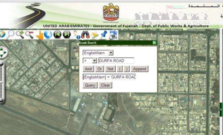


6 Customized GIS Websites Public Works, UAE Cadastral Management, Italy 6


7 Customized GIS Websites Traffic Management, TW Disaster 7 Control, TW

8 New SuperGIS Server 3.2 Effortless management Manage all settings in SuperGIS Server Manager Publish services from SuperGIS Desktop Flexible settings Overlay with OSM by one click Improved Web Applications 8

9 Questions & Comments During the presentation, you may share your comments or questions Or, you may drop us an to: Follow us on 9


10 10
11 Outline Introduction of SuperGIS Server The New SuperGIS Server 3.2 Working with SuperGIS Server Overlay with Open Map Resource 02. Design GIS web templates 03. Perform Network Analysis: Service Area 04. Build an Android GIS App to link with web maps 11

12 The New SuperGIS Server 3.2 Interface : SuperGIS Server Manager NOTE : The first login info. will be set as an administrator. 12
13 The New SuperGIS Server 3.2 SuperGIS Server Manager Provide a complete management tool with webpage Directly publish various types of GIS services, create GIS websites, and manage the settings of SuperGIS Server 13
14 Working With SuperGIS Server Overlay with Online Map Resources 14

15 Scenario 1 Visualize the distribution of ATMs in the city. Mash up with OpenStreetMap as basemap Overlay with your data A point layer - the locations of ATM 15
16 01. Overlay with Online Map Resources Key points: The coordinate system of Layers must be Web Mercator One click to overlay with OpenStreetMap Can publish services by SuperGIS Server Publisher add-on 16
17 17 Live Demonstration


18 Scenario 2 Manage your Enterprise GIS centrally Display the properties of the bank Update the latest land information from each branch, to synchronize with the headquarters for decision making. Allow real-time query and measurement Code:3928 Class:farm Lender: Capitole Borrower:Stella Smith 18
19 02. Design GIS Web Templates Quickly create new feature with default symbol settings. The corresponding attribute info will be displayed. 19
20 02. Design GIS Web Templates Edit the features and attribute data with front end applications through the Internet Just check the box to apply Feature Service 20
21 21 Live Demonstration

22 22 BREAKTIME: QUICK POLL

23 03. Perform Network Analysis: Service area 23
24 03. Network Analysis : Service area Generate network data before applying Network Analysis Build a geo-process by SuperGIS Toolkit Design the process Set the Process Parameters Set the Result and display on map Just check the box to apply the Process 24


25 Design the process A better solution for you to save time on designing the process: 25


26 Design the geo-process Set the Process Parameter Customize the Parameter s name 26
27 27 Live Demonstration


28 Mobile client applications SuperPad Support to apply Data Services Toolbar Extension to access services Support to read map service, WMS, WFS SuperSurv SuperGIS Mobile Viewer Custom applications 28


29 04. Build a GIS App to link with web maps Deploy maps and assign tasks to your field force. Browse GIS service anytime, anywhere 29

30 04. Build a GIS App to link with web maps Before creating an App, you should install : Java SE Android SDK Eclipse SuperGIS Runtime SDK All source of sample code from : Help Manual Copy SuperGIS Runtime SDK.apk to your Android device and install it Online Source Sample : SGDN 30
31 Sources of Sample Codes Help Manual Online Source: SGDN 31
32 In SGDN, you ll find more: 32
33 Link with Web Maps All the sample codes to the Android app will be written here 33
34 Link with Web Maps Name of the map service: Resource Name IP address for the SuperGIS Server, and Account and Password 34
35 35 Live Demonstration


36 Agriculture Development, Indonesia Field Survey to capture crop info & farm size Access map data from private cloud Real-time data synchronization Control accurate data to support decision making 36
37 37 BREAKTIME: QUICK POLL

38 Q&A Time Subscribe to get latest Online Training Resources 38

39 SuperGIS Server 3.2 Functionality 39
 /R2(64 bit) Windows Server 2012 R2 DataCenter (64bit) IIS:5.1 or higher.")
40 Supported formats & System requirements Vector files: GEO, SHP, MIF, DXF, DWG, DGN Raster files: SGR, MrSID, GeoTIFF, BMP, JPEG, ECW, LAN CPU: 2.2 GHz or higher RAM: 4 GB or higher Operating Systems Windows Server 2008 (32/64 bit) /R2(64 bit) Windows Server 2012 R2 DataCenter (64bit) IIS:5.1 or higher.net Framework 2.0 SP2 or higher 40


41 Supported Specs Provide many Web Application APIs for customization JavaScript Flex Silverlight Support.NET development tools Microsoft Visual Studio 2005 Microsoft Visual Studio 2008 (.Net 2.0) Microsoft Visual Studio 2010 Web browsers Internet Explorer 8.0 or higher Firefox or higher Chrome 5.0 or higher Safari 5.0 or higher Opera or higher 41

42 GIS Services Anytime, Anywhere Various types of geodatabase GIS Web service publishing OGC service Web application Various client applications Web browser Mobile GIS Desktop GIS Custom applications Integration with other resources 42
43 Upcoming Events Supergeo Webinar 20th November 3D GIS (3PM, London local time) 43
44 Thank you for your attention Subscribe to get latest Online Training Resources 44
SuperGIS Server 3.2 Value Edition Specification
 SuperGIS Server 3.2 Value Edition Specification 20140826 Specification 1. All of the services support SOAP (Simple Object Access Protocol). 2. Use map file created by SuperGIS Desktop as map services SuperGIS
Supergeo Webinar. Boost Your Field Productivity & Accuracy with SuperGIS Mobile Solutions. March 25, 2015
 Supergeo Webinar Boost Your Field Productivity & Accuracy with SuperGIS Mobile Solutions March 25, 2015 1 Presenters Olivia Lin Tech Support Engineer GIS Training & Support Center Sarah Liu Sales and Marketing
Streamlining Field Survey & Mobile Mapping by SuperSurv Jun 4, 2014
 Supergeo Webinar Streamlining Field Survey & Mobile Mapping by SuperSurv Jun 4, 2014 Sarah Liu Presenters Sales & Marketing Director International Marketing Division Danny Wang Tech Support Engineer GIS
Speaker: Sydney Lai, Eugene Tseng
 Speaker: Sydney Lai, Eugene Tseng 2017. 03 Presenters Eugene Tseng Marketing Specialist Sydney Lai Product Manager 2 Quick Poll I 3 Overview of SuperGIS Products 4 Overview of SuperPad Professional mobile
Building Java Apps with ArcGIS Runtime SDK
 Building Java Apps with ArcGIS Runtime SDK Mark Baird and Vijay Gandhi A step back in time Map making 50 years ago - http://www.nls.uk/exhibitions/bartholomew/maps-engraver - http://www.nls.uk/exhibitions/bartholomew/printing
An Introduction to GIS for developers
 An Introduction to GIS for developers Part 4: GIS Sharing Canserina Kurnia & Tom Shippee Agenda Web GIS ArcGIS Online Cloud-based ArcGIS Server ArcGIS Server on-premises ArcGIS a complete platform discover,
Using ArcGIS for Server. Javier Abadía, Esri España Peter McDaid, Esri UK
 Using ArcGIS for Server Javier Abadía, Esri España Peter McDaid, Esri UK 1. Intro 2. ArcGIS for Server = Geospatial Apps Server 3. Map Services Publishing Flow Apps 4. Spatial Functionality Services Publishing
ArcGIS Online. The Road Ahead Geoff Mortson
 ArcGIS Online The Road Ahead Geoff Mortson gmortson@esricanada.com ArcGIS Online Easily create and share maps Delivered as intelligent maps Access on virtually any device anyone, anywhere Compliments and
Cross-Platform GIS Solutions through SuperGIS Desktop. Ava Lai Sr. Support Engineer Supergeo Technologies Inc.
 Cross-Platform GIS Solutions through SuperGIS Desktop Ava Lai Sr. Support Engineer Supergeo Technologies Inc. 2 Outline With the following case scenarios, you ll have: Integration with mobile/server solution:
What s New in ArcGIS Server 10
 What s New in ArcGIS Server 10 Derek Law ArcGIS Server Product Management What s s new in ArcGIS Server 10? Agenda Highlights: Enhanced Web mapping More powerful server-based analysis Geo-collaboration
Getting Started with ArcGIS for Server. Charmel Menzel and Ken Gorton
 Getting Started with ArcGIS for Server Charmel Menzel and Ken Gorton Agenda What is ArcGIS for Server? Types of Web services Publishing resources onto the Web Clients to ArcGIS for Server Editions and
Marushka Server. Product Specification
 Introductory Information Product Marushka Server represents a new generation of tools (devices) for publication and use of GIS data in the Internet and intranet. It is built on component technology in.net
Interactive webmaps with ArcGIS. Kristel Meikas, AlphaGIS
 Interactive webmaps with ArcGIS Kristel Meikas, AlphaGIS Agenda Overview of ArcGIS tools and resources Introduction to ArcGIS APIs In depth with Flex maps In depth with JavaScript maps ArcGIS Server Publish
Esri Developer Summit in Europe Building Applications with ArcGIS Runtime SDK for Java
 Esri Developer Summit in Europe Building Applications with ArcGIS Runtime SDK for Java Mark Baird Mike Branscomb Agenda Introduction SDK Building the Map Editing Querying Data Geoprocessing Asynchronous
ArcGIS Viewer for Microsoft Silverlight An Introduction
 Esri International User Conference San Diego, CA Technical Workshops July 12, 2011 ArcGIS Viewer for Microsoft Silverlight An Introduction Art Haddad, Rich Zwaap, and Derek Law Agenda Background Product
ESRI Software Evolution
 ArcGIS Jan Šlahař About ESRI ESRI - Environmental Systems Research Institute Founded in 1969, Redlands, California In 2002 Esri had approximately a 36 percent share of the GIS software market worldwide
Developing Qt Apps with the Runtime SDK
 Developing Qt Apps with the Runtime SDK Thomas Dunn and Michael Tims Esri UC 2014 Technical Workshop Agenda Getting Started Creating the Map Geocoding and Routing Geoprocessing Message Processing Work
ArcGIS Runtime SDK for.net Getting Started. Jo Fraley
 ArcGIS Runtime SDK for.net Getting Started Jo Fraley Agenda What is the ArcGIS Runtime? What s new for ArcGIS developers? ArcGIS Runtime SDK 10.2 for WPF ArcGIS Runtime SDK for.net Building Windows Store
ICIT. Brian Hiller ESRI Account Manger. What s new in ArcGIS 10
 ICIT Brian Hiller ESRI Account Manger What s new in ArcGIS 10 ArcGIS 10 Fast Easy Powerful Everywhere late June 2010 ArcGIS System for Geographic Information Desktop Server Mobile Online A System A Complete
SkylineGlobe - Products Overview
 SkylineGlobe - Products Overview Skyline Software Systems, Inc. is a leading provider of 3D earth visualization software and services. The company offers a comprehensive platform of applications, tools
What is coming in. ArcGIS Server 10. Ismael Chivite ArcGIS Server Product Manager James Cardona Technical Marketing
 What is coming in ArcGIS Server 10 Ismael Chivite ArcGIS Server Product Manager James Cardona Technical Marketing ArcGIS Server is a complete server based GIS Delivering GIS with powerful services and
ArcGIS for Mobile An Introduction. Bonnie Stayer
 ArcGIS for Mobile An Introduction Bonnie Stayer Benefits of mobile GIS? Accessibility Timely Decisionmaking Efficiency and Accuracy Rapid Data Collection Types of mobile solutions? Apps & APIs Functionality
ArcGIS Runtime SDK for WPF
 Esri Developer Summit in Europe November 9 th Rotterdam ArcGIS Runtime SDK for WPF Mike Branscomb Mark Baird Agenda Introduction SDK Building the Map Query Spatial Analysis Editing and Geometry Programming
ArcGIS Runtime SDK for Qt: Building Apps. Koushik Hajra and Lucas Danzinger
 ArcGIS Runtime SDK for Qt: Building Apps Koushik Hajra and Lucas Danzinger Cross-platform apps Agenda for today Intro to Qt Framework and ArcGIS Runtime SDK for Qt App design patterns with this SDK SDK
SDI SOLUTIONS FOR INSPIRE: TECHNOLOGIES SUPPORTING A FRAMEWORK OF COOPERATION
 SDI SOLUTIONS FOR INSPIRE: TECHNOLOGIES SUPPORTING A FRAMEWORK OF COOPERATION Roberto Lucchi 1, Marten Hogeweg 1, Guenther Pichler 2 1 Esri, Redlands, CA, USA 2 Esri Kranzberg, Germany 1 Vision INSPIRE
Introduction to Autodesk MapGuide EnterpriseChapter1:
 Chapter 1 Introduction to Autodesk MapGuide EnterpriseChapter1: In this chapter, you review the high-level key components that make up Autodesk MapGuide Enterprise. The Autodesk MapGuide Studio, an integral
MrSID Plug-in for 3D Analyst
 LizardTech MrSID Plug-in for 3D Analyst User Manual Copyrights Copyright 2009 2010 LizardTech. All rights reserved. Information in this document is subject to change without notice. The software described
Providing Interoperability Using the Open GeoServices REST Specification
 2013 Esri International User Conference July 8 12, 2013 San Diego, California Technical Workshop Providing Interoperability Using the Open GeoServices REST Specification Satish Sankaran Kevin Sigwart What
Tom Brenneman. Good morning and welcome, introductions and thank you for being here.
 Welcome Tom Brenneman Good morning and welcome, introductions and thank you for being here. This is a best practices seminar. We're going to be sharing with you what we found to be best practices that
SYSTEM REQUIREMENTS M.APP ENTERPRISE
 SYSTEM REQUIREMENTS M.APP ENTERPRISE Description or Document Category October 06, 2016 Contents M.App Enterprise Server... 3 Hardware requirements... 3 Disk space requirements... 3 Production environment
Getting Started with ArcGIS Runtime SDK for Java SE
 Getting Started with ArcGIS Runtime SDK for Java SE Elise Acheson, Vijay Gandhi, and Eric Bader Demo Source code: https://github.com/esri/arcgis-runtime-samples-java/tree/master/devsummit-2014 Video Recording:
Desktop. ArcGIS Server. ArcGIS
 Getting Started with ArcGIS Server Nakul Bhatia and David Crosby ESRI Charlotte 1 Agenda g Overview of ArcGIS Server 9.3.1 Working with GIS Services Using g Web GIS Service Clients ArcGIS Online Map Caching
System Design and Tuning
 System Design and Tuning Lucity 2018 R2 Overview Lucity Specifications 2018 R2 Web Identity Server Document Server File Server Database Server Service Server Citizen Portal Mobile Server Android Devices
The license server and all workstations that will run applications dependent on network licensing must run TCP/IP protocol.
 Autodesk AutoCAD 2020 - including specialized toolsets System requirements Supported operating systems Microsoft Windows 7 SP1 with Update KB4019990 (64-bit only) Microsoft Windows 8.1 with Update KB2919355
Report Exec Dispatch System Specifications
 Report Exec Dispatch System Specifications Contents Overview... 2 Technical Support... 2 At a Glance... 2 Report Exec Systems Diagram... 3 Server Specifications... 4 Server OS... 4 Microsoft SQL Server...
ArcGIS Runtime SDK for Java: A Beginner s Guide. Mark Baird JC Malott
 ArcGIS Runtime SDK for Java: A Beginner s Guide Mark Baird JC Malott Outline Intro to ArcGIS Runtime SDKs Get started: download and install the SDK Tour of the functionality of the API Basics of building
The TLC GIS Web Development Strategy Tallahassee - Leon County Geographic Information Systems
 The TLC GIS Web Development Strategy Tallahassee - Leon County Geographic Information Systems As presented by Lee Hartsfield, GISP Tallahassee-Leon County GIS Coordinator Outline * Tallahassee-Leon County
Getting Started with ArcGIS Runtime SDK for Qt. Thomas Dunn & Nandini Rao
 Getting Started with ArcGIS Runtime SDK for Qt Thomas Dunn & Nandini Rao Agenda Getting Started Creating the Map Geocoding and Routing Geoprocessing Message Processing Work Offline The Next Release ArcGIS
Advances in GIS help create Smarter Communities
 Advances in GIS help create Smarter Communities POP(ovich) Quiz Who is a Desktop User? Who is an ArcGIS Online User? Who is a ArcGIS Server Admin? Who is a Programmer? Who works with or for a government
May 22, 2013 Ronald Reagan Building and International Trade Center Washington, DC USA
 May 22, 2013 Ronald Reagan Building and International Trade Center Washington, DC USA 1 Building Applications with Oracle MapViewer LJ Qian (lj.qian@oracle.com) Director, Software Development The following
Working with the ArcGIS Viewer for Flex Application Builder
 Working with the ArcGIS Viewer for Flex Application Builder Esri Canada User Conference St. John s November 15, 2012 Presented By: Greg Yetman gyetman@esri.ca Agenda This seminar is designed to help you
iprova Suite System requirements iprova 5.8/5.9 On-premises
 iprova Suite System requirements iprova 5.8/5.9 On-premises Attention This document contains the system requirements for versions 5.8 & 5.9 of the iprova Suite. New developments may result in changing
OPEN SOURCE SOLUTIONS FOR SURVEYORS
 2 nd Sabah International Surveyors Congress 11 th 12 th March 2014 OPEN SOURCE SOLUTIONS FOR SURVEYORS Presented By : Sr Alexander Chong Director, Jurukur Antarabangsa The Benefits Of Closed Proprietary
ArcGIS GeoEvent Server: Making 3D Scenes Come Alive with Real-Time Data
 ArcGIS GeoEvent Server: Making 3D Scenes Come Alive with Real-Time Data Morakot Pilouk, Ph.D. Senior Software Developer, Esri mpilouk@esri.com @mpesri Agenda 1 2 3 4 5 6 3D for ArcGIS Real-Time GIS Static
Introduction to Autodesk MapGuide EnterpriseChapter1:
 Chapter 1 Introduction to Autodesk MapGuide EnterpriseChapter1: In this chapter, you review the high-level key components that comprise Autodesk MapGuide Enterprise. The Autodesk MapGuide Studio, an integral
ArcPad An Introduction
 2013 Esri International User Conference July 8 12, 2013 San Diego, California Technical Workshop ArcPad An Introduction Chris LeSeuer, Marika Vertzonis, Hannah Ferrier Esri UC2013. Technical Workshop.
Online Access: Login to The Media Audit
 Online Access: Login to The Media Audit Using The Media Audit online has never been easier! Simply open your web browser and follow the quick instructions below. app.themediaaudit.com Open your favorite
City of Mobile GIS Web Mapping Applications: New Technology, New Expectations
 City of Mobile GIS Web Mapping Applications: New Technology, New Expectations Presenters : Scott Kearney GIS Manager Patricia Creamer GIS Analyst Background: GIS Department Developing web mapping apps
GEOMEDIA SMART CLIENT 2015 PRODUCT FEATURES AND COMPARISONS
 GEOMEDIA SMART CLIENT 2015 PRODUCT FEATURES AND COMPARISONS GeoMedia Smart Client enables the entire organization to access and utilize rich geospatial data in their business processes. It delivers an
EUCOM/AFRICOM DEFENSE USER GROUP MEETING MARCH 2010 STUTTGART WELCOME!
 EUCOM/AFRICOM DEFENSE USER GROUP MEETING 23-25 MARCH 2010 STUTTGART WELCOME! AGENDA March 23, Tuesday 0800-0900 Registration 0900-0915 Welcome and Introductions 0915-1000 Getting Started with ArcGIS Server
Building Applications with the ArcGIS Runtime SDK for WPF
 Esri International User Conference San Diego, California Technical Workshops 24 th July 2012 Building Applications with the ArcGIS Runtime SDK for WPF Euan Cameron & Paul Pilkington Agenda Introduction
RightNow August 08 Workstation Specifications
 RightNow August 08 Workstation Specifications To maximize the performance of RightNow August 08 staff members and customers, we recommend the following workstation hardware configurations, operating systems,
Using Geoprocessing Services with ArcGIS Web Mapping APIs
 Esri Developer Summit in Europe November 12 London Using Geoprocessing Services with ArcGIS Web Mapping APIs Simon Liu, Andy Gup Who are your presenters? Simon Liu, Esri U.K. GIS Developer sliu@esriuk.com
An Overview of FMW MapViewer
 An Overview of FMW MapViewer Agenda What is MapViewer Select Features Getting Started Additional Resources 2 Copyright 2013, Oracle and/or its affiliates. All rights reserved. Oracle
ArcGIS Online: Managing Data. Jeremy Bartley Sentha Sivabalan
 ArcGIS Online: Managing Data Jeremy Bartley (jbartley@esri.com) Sentha Sivabalan (ssivabalan@esri.com) Agenda Creating and managing content like Apps, Maps, Scenes and Layers in ArcGIS Today s Topics:
Dynamic Situational Awareness. Through Developer Applications
 Dynamic Situational Awareness Through Developer Applications Mission Focused Applications Building Apps to support operations Agile Simple High-Performance Defense Developers GIS Simplifies Working With
ArcGIS Runtime: Building 3D Apps. Rex Hansen Adrien Meriaux
 ArcGIS Runtime: Building 3D Apps Rex Hansen Adrien Meriaux Agenda 3D across the ArcGIS Platform 3D in ArcGIS Runtime Road ahead ArcGIS 3D helps customers Create and Manage Design and Simulate Visualize
Working with Feature Layers. Russell Brennan Gary MacDougall
 Working with Feature Layers Russell Brennan Gary MacDougall Working with Feature Layers Session will focus on feature access and editing Highlight new features added over the last few releases Agenda Introduction
Report Exec Enterprise System Specifications
 Report Exec Enterprise System Specifications Contents Overview... 2 Technical Support... 2 At a Glance... 2 Report Exec Systems Diagram... 4 Hardware Specifications... 6 SQL Server... 6 RAM... 6 Processor...
Getting Started with the ArcGIS Server JavaScript API
 Getting Started with the ArcGIS Server JavaScript API Agenda Introduction ArcGIS Server services and mashups REST API Services Directory JavaScript API ArcGIS Server Resource Center Dojo Maps, layers,
Croatian Motorways Road Database Management System
 Croatian Motorways Road Database Management System Marko Turković FOSS4G-Europe 2014 Presentation overview About us System introduction System component architecture Kosmo Desktop WebGIS portal Future
ArcGIS Runtime SDKs Building Offline Apps. Nick Furness
 ArcGIS Runtime SDKs Building Offline Apps Nick Furness Agenda The basics - Considerations - Building blocks - Service types New! Offline maps New! Preplanned workflow What we are covering and what not
Best Practices for Creating Web Maps. Brian Chong Justin Fan
 Best Practices for Creating Web Maps Brian Chong Justin Fan Agenda Overview of web maps Designing maps for the web Develop effective web maps What is a Web Map? Contains one or more GIS services Integrated
Web App Builder: Code-free Development. Adam Ziegler, Esri-Northeast, Local Government Team
 Web App Builder: Code-free Development Adam Ziegler, aziegler@esri.com Esri-Northeast, Local Government Team Agenda Product overview Web AppBuilder for ArcGIS tour Adding Custom Widgets Community and Resources
Microsoft Dynamics NAV Windows Client Requirements
 Microsoft Dynamics NAV Windows Client Requirements The following table shows the minimum system requirements for the Microsoft Dynamics NAV Windows client. Supported operating systems Windows 8.1 Professional
Extend GIS. The Reach. Of Your GIS. Chris Cappelli Nathan Bennett
 Extend The Reach GIS Of Your GIS Chris Cappelli Nathan Bennett Where do your co-workers, managers, customers, and citizens go when they want to find or make a map? GIS is a practical system for problem
Getting Started with ArcGIS Runtime SDK for the Microsoft.NET Framework. Morten Nielsen Mike Branscomb Antti Kajanus Rex Hansen
 Getting Started with ArcGIS Runtime SDK for the Microsoft.NET Framework Morten Nielsen Mike Branscomb Antti Kajanus Rex Hansen Agenda What is the ArcGIS Runtime? ArcGIS Runtime SDK for.net - Platform -
Free to download and distribute from
 Topics for this session Introduction Overview of features Using ArcGIS Explorer effectively Customization New features & capabilities Demonstrations *Note: Explorer 1200 What is ArcGIS Explorer GIS for
Trimble GeoCollector for ArcGIS: An Introduction. Morgan Zhang (Esri), Matthew Morris (Trimble)
, Matthew Morris (Trimble)") Trimble GeoCollector for ArcGIS: An Introduction Morgan Zhang (Esri), Matthew Morris (Trimble) Overview Introduction to mobile GIS Overview of ArcGIS for Windows Mobile Overview of Trimble Positions software
Trimble GeoCollector for ArcGIS: An Introduction Morgan Zhang (Esri), Matthew Morris (Trimble) Overview Introduction to mobile GIS Overview of ArcGIS for Windows Mobile Overview of Trimble Positions software
Goals Give you an overview of development with ArcGIS Server Give you a roadmap to other sessions Cover the breadth of the software Not a deep dive se
 ArcGIS Server 9.2: An Overview for Developers Sud Menon, Rex Hansen, Antony Jayaprakash, Mike Shaw Art Haddad, Jay Theodore, Fred Aubry Anne Reuland, David Cordes, Jeff Shaner, Dave Wrazien Developer Summit
Building Android Apps Runtime SDK for Android
 Building Android Apps Runtime SDK for Android Dan O Neill & Alan Lucas Introductions What do you do What do we do - Android Development Team - Edinburgh Alan Lucas - https://github.com/alan-edi - Alaska
Manufacturing & Supply Chain Suite. Suite. V10.1 Platform Specifications that are supported. Supply Chain Management (SCM)
") lant Scheduler Supply lanner Aspen Scheduling Insight lanning Board V10.1 latform Specifications that are supported Operating Systems ( only) Windows 10 Anniversary (2nd LTSB) Enterprise & rofessional
lant Scheduler Supply lanner Aspen Scheduling Insight lanning Board V10.1 latform Specifications that are supported Operating Systems ( only) Windows 10 Anniversary (2nd LTSB) Enterprise & rofessional
A Developers Guide To Mobile GIS. David Cardella, Jeff Shaner
 A Developers Guide To Mobile GIS David Cardella, Jeff Shaner What is mobile GIS? Extends the reach of ArcGIS from the office to the field With a mobile GIS solution you can: - Carry your maps to the field
Enabling High-Quality Printing in Web Applications. Tanu Hoque & Craig Williams
 Enabling High-Quality Printing in Web Applications Tanu Hoque & Craig Williams New Modern Print Service with ArcGIS Enterprise 10.6 Quality Improvements: Support for true color level transparency PDF produced
Using Collector for ArcGIS and Operations Dashboard for ArcGIS. Mike Sweeney Esri-Charlotte
 Using Collector for ArcGIS and Operations Dashboard for ArcGIS Mike Sweeney Esri-Charlotte Agenda The ArcGIS Platform Desktop Web Device Portal Cloud Server Online Content and Services On-Premises Available
8-Channel IP Surveillance Kit. Network UM C8CHIPSKIT V1.0
 8-Channel IP Surveillance Kit Network UM C8CHIPSKIT V1.0 Network Access Description CPU Requirement Pentium 4 3.0GHz or above Operating System Windows XP/ Vista/ 7 / 8 / 8.1 Memory Video Network (LAN)
EMS DESKTOP CLIENT Installation Guide
 EMS DESKTOP CLIENT Installation Guide Version 44.1 Last Updated: March 5, 2018 EMS Software emssoftware.com/help 800.440.3994 2018 EMS Software, LLC. All Rights Reserved. Table of Contents CHAPTER 1: Introduction
P P P P P P P P P P P P P P P P
 V9 latform Specification AES roperty System rocess Modeling (Aspen lus) rocess Modeling (Aspen HYSYS) Operating Systems (64-bit only) Windows 10 Enterprise & rofessional (64-bit) Windows 8.1 Update 1 Enterprise
How to become an INSPIRE node and fully exploit the investments made?
 How to become an INSPIRE node and fully exploit the investments made? Solution patterns for consumers: end users & developers (2/2) Roberto Lucchi 22 June 2010, Krakow 1 Geoportal extension Enabling discovery
SeeTest Quality Assurance Platform On-premise Digital Assurance Lab
 SeeTest Quality Assurance Platform On-premise Digital Assurance Lab On-premise Digital Assurance Lab Centrally manage browsers & mobile devices (physical/emulated), and allow your team to remotely access
Getting Started with the ArcGIS API for JavaScript. Julie Powell, Paul Hann
 Getting Started with the ArcGIS API for JavaScript Julie Powell, Paul Hann Esri Developer Summit Berlin November 19 2012 Getting Started with the ArcGIS API for JavaScript ArcGIS for Server Is a Platform
Discovery and Access of Geospatial Resources Using GIS Portal Toolkit Marten Hogeweg Product Manager GIS Portal Toolkit
 Discovery and Access of Geospatial Resources Using GIS Portal Toolkit Marten Hogeweg Product Manager GIS Portal Toolkit Outline Elements of Spatial Data Infrastructures Current trends Position of GIS portals
PaperSaveCloud TM Pre- Requisites
 PaperSaveCloud TM Pre- Requisites 6.0 Service Pack 2 3150 SW 38th Avenue, 11th Floor, Miami, Florida 33146. USA 877 727 3799 305 373 0056 www.papersave.com PaperSave is a product of WhiteOwl - www.gowhiteowl.com
Product-Specific Terms of Use
 Product-Specific Terms of Use SOFTWARE The following list identifies additional terms of use that apply to specific SoftwareProducts. Each Product listing identifies one or more footnotes that apply to
Engineering Suite. Suite. V10.1 Platform Specifications that are supported. Operating Systems (64-bit only) Microsoft Office.
 Microsoft Office.") V10.1 latform Specifications that are supported AES roperty System rocess Modeling (Aspen lus) 2 rocess Modeling (Aspen HYSYS) Operating Systems (64-bit only) Windows 10 Anniversary (2nd LTSB) Enterprise
V10.1 latform Specifications that are supported AES roperty System rocess Modeling (Aspen lus) 2 rocess Modeling (Aspen HYSYS) Operating Systems (64-bit only) Windows 10 Anniversary (2nd LTSB) Enterprise
User System Requirements
 The system requirements for end users to host and access meetings. Common PC System Requirements, page 1 Operating System Requirements for Windows, page 2 Operating System Requirements for MAC, page 3
Local. Responsive. Reliable.
 Local. Responsive. Reliable. FAQs WHAT IS myvrb? myvrb is the new name of your online and mobile banking experience at Valley Republic Bank. While you will continue to access online and mobile banking
Features and Benefits
 AUTODESK MAPGUIDE ENTERPRISE 2010 Features and Benefits Extend the reach and value of your spatial information using Autodesk MapGuide Enterprise 2010 software. Access design and spatial data from a variety
Kaltura Video Allowing Third-Party Cookies
 Kaltura Video Allowing Third-Party Cookies - In order for you to access the Kaltura platform/services, you will first need to ensure that your primary web browser (the one you will use to access your D2L
Product Information
 Product Information 17.0.0.500 TOBESOFT strives to maintain the accuracy of information provided in this document and will consistently modify and supplement it. However, we cannot guarantee accuracy of
Online and Mobile Banking Requirements Guide
 Online and Mobile Banking Requirements Guide Introduction This document explains the hardware and software requirements for Valley First Credit Union s Online and Mobile Banking Experience. Members are
ArcGIS for Mobile Devices: An Overview. Jeff Shaner Bonnie Stayer
 ArcGIS for Mobile Devices: An Overview Jeff Shaner Bonnie Stayer Agenda Esri Positioning and Key Benefits Your Mobility Strategy Q & A Positioning and Benefits Key Benefits of Mobile Solutions Leverage
Mediaocean Aura Technical Overview
 Mediaocean Aura Technical Overview January 2017 Samir Sadikhov +61 (2) 9879 8200 apac_operations@mediaocean.com Contents INTRODUCTION... 2 APPLICATION ARCHITECTURE OVERVIEW... 3 DATA LAYER...3 APPLICATION
gvsig Lecture 3 gvsig: an advanced GIS client
 gvsig Lecture 3 gvsig: an advanced GIS client INDEX What is gvsig Features Supported formats Main Functions Developers guide to gvsig Internal organization Object model Used libraries Plugins The future
gvsig goes Mobile. Miguel Montesinos Project Manager Member of gvsig technical committee Member of gvsig management committee
 gvsig goes Mobile. Miguel Montesinos Project Manager Member of gvsig technical committee Member of gvsig management committee Javier Carrasco Project Development Chief gvsig developer 1 Agenda Introduction
Leveraging OGC Services in ArcGIS Server. Satish Sankaran, Esri Yingqi Tang, Esri
 Leveraging OGC Services in ArcGIS Server Satish Sankaran, Esri Yingqi Tang, Esri GIS Creating and Managing Geo Information Products - Proprietary - Open Specifications - Standards Dissemination of Geo
ViewDirect-ABS 7.0 Support Matrix Updated: March 2, 2017
 ViewDirect-ABS 7.0 Support Matrix Updated: March 2, 2017 NOTE: ABSNet 7.0 is a 64-bit application and requires a 64-bit operating system, application server, and JVM to function. ABSWeb Explorer Browser
Welcome to MyKangan! A how to guide for student. Welcome to MyKangan. A How to guide for students
 Welcome to MyKangan A How to guide for students May 2015 Contents Welcome to MyKangan... 1 Logging in... 2 Accessing MyKangan via the Student Portal ONSITE... 2 Accessing MyKangan via the Student Portal
Introduction to ArcGIS Server 10.1
 Introduction to ArcGIS Server 10.1 E-Learning for the GIS Professional Any Time, Any Place! geospatialtraining.com Module Outline What is ArcGIS Server? GIS Resources and Services ArcGIS Server Components
Leveraging OGC Standards on ArcGIS Server
 Leveraging OGC Standards on ArcGIS Server Satish Sankaran Interoperability and Standards Team James Michel III ESRI Intel Team ArcGIS Server Complete Interoperable Server-Based GIS Desktop Explorer Web