Cross-Platform GIS Solutions through SuperGIS Desktop. Ava Lai Sr. Support Engineer Supergeo Technologies Inc.
|
|
|
- Augustine Tyler
- 5 years ago
- Views:
Transcription


1 Cross-Platform GIS Solutions through SuperGIS Desktop Ava Lai Sr. Support Engineer Supergeo Technologies Inc.
2 2
3 Outline With the following case scenarios, you ll have: Integration with mobile/server solution: Cache Generator Conduct Survey with paper work Transfer the survey data in GNSS signal to GIS Check the GIS data with PDF Reader 3


4 SuperGIS Desktop: basic Common use tool: zoom in/out, pan etc. Right click to call out other extensions or add-ons 4

5 Generate Cache Map Why we need to have Cache Map? Survey in the field by using mobile solution Without internet connection How to ensure the location and start to do the survey? 5


6 Generate Cache Map Cache Generator in SuperGIS Desktop Produce.stc Supergis file Tile Cache : color, pattern, labeling etc. Even visible scale 6


7 View in SuperGIS Desktop From the tool: Add Layer Properties settings to display the layers 7


8 How to Use in Mobile Device Setup for the base map in your mobile device Even Better!.stc file 8
9 BREAKTIME: QUICK POLL I Subscribe SupergeoTV now! 9


10 Survey in Field: Parcel Paper work: scan into digital data Data collected by GPS: GPX or KML format 10


11 Work Flow 1 as: Survey in Field Paper Work Scan and transfer into Digital Data Given the data with Correct Coordinate Digitize work on GIS data: Edit COGO / Advanced Editor 11


12 How to Give a Correct Coordinate for the Raster Data Gives raster data a correct position Rotate Shift Scale etc. 12


13 Georeferencing Tool Rotate / Shift / Scale Flip / Rotate Auto Adjust Reset Transformation Control Point List Rectify (at least 4 pairs of control point) 13

14 Start to Do Georeferencing The raster data which needs to be given the correct coordinate The GIS data with correct coordinate, which is used to be the comparison

15 Digitize the Work: Precise Mapping Base on your survey work, which including every detail, ex: length, direction etc., and you need to digitize GIS data on your computer. 15


16 Tools for Precise Mapping Advanced Editor More tools for smart editing, ex: Copy Tools COGO Construct the line with direction and distance Proportionally Cul-De-Sac OffsetLine COGO Area Auto Intersection 16


17 Traverse Create the next vertex with direction and distance Direction-Distance Angle-Distance


18 Offset Line Create the parallel line by input the offset and length 18
19 DEMO TIME FOR WORK FLOW 1 Subscribe SupergeoTV now! 19


20 Work Flow 2 as: Survey in Field GPS Data: GPX / KML Convert into GIS data: Point Line Polygon Digitize work on GIS data: Edit COGO / Advanced Editor 20
21 Digitize the Work: Precise Mapping Base on the survey work, which recorded by GNSS signals, in GPX or KML format GPS (x1,y1) (x2,y2) (x3,y3) (x4,y4) (x5,y5) 21


22 From GPS data to GIS data Way 1: SuperGIS DataConvertor Way 2: SuperGIS Toolkit 22
 (x1,y1) Save the time to")
 (x4,y4) (x3,y3) Connecting points to a line by their")
23 GPS Point to Line Convert the points to line The collected survey points can be converted as a line (x2,y2) (x1,y1) Save the time to digitize Increase the accuracy of the line that is generated from the points (x5,y5) (x4,y4) (x3,y3) Connecting points to a line by their FID order 23


24 The other functions Advanced Editor: Copy Tool 2-Point Line Split Proportionally Point to Line COGO: COGO Area COGO Report Split into COGO lines etc. 24


25 DEMO TIME FOR WORK FLOW 2 Subscribe SupergeoTV now! 25

26 BREAKTIME: QUICK POLL II Subscribe SupergeoTV now! 26


27 What s next if we don t have any GIS related software? How to check the GIS data? How to view the information of the data? Have you heard about Geospatial PDF? 27


28 View GIS Data in PDF Create the maps for field tasks. You can use Geospatial PDF to view the GIS data, with coordinates. Real-time GPS signal 28

 By")
29 Export to Geospatial PDF Using SuperGIS Toolkit: Map To PDF By Layers (Default) By Features 29
 Attribute query Spatial query Measuring Distance Perimeter Area Geospatial")
30 View the GIS Data in PDF View the Geospatial PDF by PDF reader Query (Object Data Tool) Attribute query Spatial query Measuring Distance Perimeter Area Geospatial Location 30


31 View the GIS Data in PDF View the Geospatial PDF by mobile device 31


32 Q&A Time Contact us: Subscribe SupergeoTV now!
Speaker: Sydney Lai, Eugene Tseng
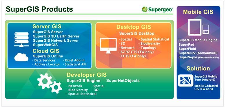
 Speaker: Sydney Lai, Eugene Tseng 2017. 03 Presenters Eugene Tseng Marketing Specialist Sydney Lai Product Manager 2 Quick Poll I 3 Overview of SuperGIS Products 4 Overview of SuperPad Professional mobile
Streamlining Field Survey & Mobile Mapping by SuperSurv Jun 4, 2014
 Supergeo Webinar Streamlining Field Survey & Mobile Mapping by SuperSurv Jun 4, 2014 Sarah Liu Presenters Sales & Marketing Director International Marketing Division Danny Wang Tech Support Engineer GIS
Supergeo Webinar. Boost Your Field Productivity & Accuracy with SuperGIS Mobile Solutions. March 25, 2015
 Supergeo Webinar Boost Your Field Productivity & Accuracy with SuperGIS Mobile Solutions March 25, 2015 1 Presenters Olivia Lin Tech Support Engineer GIS Training & Support Center Sarah Liu Sales and Marketing
Lab 6: Transforming Spatial Data
 Lab 6: Transforming Spatial Data Objectives: The primary objectives of this lab are to georeference a raster dataset and to create GIS data by digitizing features from an image as a backdrop. Specifics:
SuperGIS Server 3.2 Value Edition Specification
 SuperGIS Server 3.2 Value Edition Specification 20140826 Specification 1. All of the services support SOAP (Simple Object Access Protocol). 2. Use map file created by SuperGIS Desktop as map services SuperGIS
What s New in Desktop 10.1
 What s New in Desktop 10.1 Damian Spangrud Esri Redlands Trip Down Memory Lane ArcGIS A Complete System for Geographic Information Cloud Web Online Mobile Enterprise Desktop Sharing Information sharing
Supergeo Webinar. Make Enterprise GIS Data & Service Available Anytime, Anywhere. Oct 29, 2014
 Supergeo Webinar Make Enterprise GIS Data & Service Available Anytime, Anywhere Oct 29, 2014 Presenters Olivia Lin Tech Support Engineer GIS Training & Support Center Sarah Liu Sales and Marketing Director
Release 4.1. Description
 Leica MobileMatriX Release 4.1 Products - Options Packages - Hardware Description Leica MobileMatriX 4.1 Leica Geosystems, 2004-2010 1 PRODUCTS Three different Editions are available: Standard Edition
ArcMap: Tips and Tricks
 Esri International User Conference San Diego, California Technical Workshops July 23 27, 2012 ArcMap: Tips and Tricks Miriam Schmidts Jorge Ruiz-Valdepena Agenda Navigating ArcMap Repairing data links
Getting Started with EZTag CE
 Getting Started with EZTag CE Version 2.97 2012-2017 Effigis. All rights reserved. 1 Summary Actions TO DO ONCE Get ready with a Windows Mobile unit Install and license Create a data dictionary Configure
Geography 104 Instructors: Judd Curran & Mark Goodman. LAB EXERCISE #3 Data Analysis - Buffering (25pts)
") Instructors: Judd Curran & Mark Goodman Name: LAB EXERCISE #3 Data Analysis - Buffering (25pts) Transformations in GIS are methods that transform GIS objects and databases into more useful products using
Instructors: Judd Curran & Mark Goodman Name: LAB EXERCISE #3 Data Analysis - Buffering (25pts) Transformations in GIS are methods that transform GIS objects and databases into more useful products using
Georeferencing Imagery in ArcGIS 10.3.x
 Georeferencing Imagery in ArcGIS 10.3.x Georeferencing is the process of aligning imagery (maps, air photos, etc.) with spatial data such as point, lines or polygons (for example, roads and water bodies).
Guide to Mapping Website (Public) December 2016 GC_236594
 December 2016 GC_236594") Guide to Mapping Website (Public) December 2016 GC_236594 Table of Contents Guide to Mapping Website (Public)... 1 December 2016... 1 Quick Start... 3 Map Layers... 4 How do I?... 5 Draw on the Map...
Guide to Mapping Website (Public) December 2016 GC_236594 Table of Contents Guide to Mapping Website (Public)... 1 December 2016... 1 Quick Start... 3 Map Layers... 4 How do I?... 5 Draw on the Map...
GEO/GY461 Applied GIS: Environmental Geology of the Cheaha Mountain, AL, 7.5' Quadrangle Project
 Figure 1: Reference points spreadsheet for Cheaha Mt. 7.5' quadrangle (LatLongCalc_24k.xls). Page -1- Figure 2: RMS statistic from the Cheaha Mountain field map georeference. Page -2- Figure 3: Appearance
ArcMap Editing Tips and Tricks. Sean Jones
 ArcMap Editing Tips and Tricks Sean Jones Overview Topics - Tuning your editing map - Creating features - Editing features and attributes - Aligning and editing coincident features - Addins Format - Software
TBC v License Matrix - Rev 0
 Command Name Viewer (Unlicensed) Base Intermediate Advanced Advanced Drafting Aerial Photogrammetry Data Prep GIS Scanning Tunneling Category 3D Preset Views x x x x General Software 3D View Projection
Field Validation. Background: Initial concept: 1 st step:
 Field Validation Background: When creating complex GIS databases, it is essential that all or a significant portion of the digitized (or acquired) data should to be validated; this is done with various
RAPIDMAP Geocortex HTML5 Viewer Manual
 RAPIDMAP Geocortex HTML5 Viewer Manual This site was developed using the evolving HTML5 web standard and should work in most modern browsers including IE, Safari, Chrome and Firefox. Even though it was
Visualization with ArcGlobe. Brady Hoak
 Visualization with ArcGlobe Brady Hoak Contents What is ArcGlobe? 3D Mapping and ArcGlobe Displaying data in ArcGlobe ArcGlobe tools Tips for constructing ArcGlobe documents New at ArcGIS 9.3 ArcGIS integration
ETS Combined inspection
 ETS Combined inspection Baveno, October 15, 2013 Slavko LEMAJIC www.jrc.ec.europa.eu Serving society Stimulating innovation Supporting legislation Outline Background Scope and purpose Procedure Tool congruency
Name: Date: June 27th, 2011 GIS Boot Camps For Educators Lecture_3
 Name: Date: June 27th, 2011 GIS Boot Camps For Educators Lecture_3 Practical: Creating and Editing Shapefiles Using Straight, AutoComplete and Cut Polygon Tools Use ArcCatalog to copy data files from:
OnCOR Silverlight Viewer Guide
 Getting Around There are many ways to move around the map! The simplest option is to use your mouse in the map area. If you hold the left button down, then click and drag, you can pan the map to a new
Reset Cursor Tool Clicking on the Reset Cursor tool will clear all map and tool selections and allow tooltips to be displayed.
 SMS Featured Icons: Mapping Toolbar This document includes a brief description of some of the most commonly used tools in the SMS Desktop Software map window toolbar as well as shows you the toolbar shortcuts
Blacksburg, VA July 24 th 30 th, 2010 Digitizing and Analyzing Data Page 1
 Digitizing and Analyzing Data John McGee Jennifer McKee Prepared by: With support from: NSF DUE-0903270 in partnership with: Geospatial Technician Education Through Virginia s Community Colleges (GTEVCC)
Development Authority of the North Country (DANC) Internet Mapping Application Instructions Public Viewer 1. Purpose. 2. Logging-in. 3.
 Internet Mapping Application Instructions Public Viewer 1. Purpose. 2. Logging-in. 3.") Development Authority of the North Country (DANC) Internet Mapping Application Instructions Public Viewer 1. Purpose The purpose of this document is to outline basic functionality of the DANC Internet
Development Authority of the North Country (DANC) Internet Mapping Application Instructions Public Viewer 1. Purpose The purpose of this document is to outline basic functionality of the DANC Internet
Mid-West ESRI Utility User s Group Conference. March 26, 2014
 Mid-West ESRI Utility User s Group Conference March 26, 2014 Presented by: Hillary Bjorstrom, GIS Analyst STAR Energy Services LLC 1 What are Data Driven Pages? Data Driven Pages Workflow Creating an Index
M c i r c os o t S at a io i n o n an a d n d A lll lth T i h n i g n s g s P D P F Agenda
 MicroStation and All Things PDF Agenda Basic PDF Creation from within MicroStation PDF Printer Drivers Printing 3D Design Geometry to a PDF File Sending Geospatial Data to a PDF Exporting Business Data
Quick Guide to MapWindow GIS Desktop Application
 Quick Guide to MapWindow 1 Quick Guide to MapWindow GIS Desktop Application Version 2 January 2007 Adapted by Tom Croft. This is a summary user guide for commonly used tools and capabilities and does not
Field Validation Exercise
 Field Validation Exercise Background: When creating complex GIS databases, it is essential that all or a significant portion of the digitized (or acquired) data should to be validated; this is done with
Introduction to Geodatabase and Spatial Management in ArcGIS. Craig Gillgrass Esri
 Introduction to Geodatabase and Spatial Management in ArcGIS Craig Gillgrass Esri Session Path The Geodatabase - What is it? - Why use it? - What types are there? - What can I do with it? Query Layers
Sharing Web Layers and Services in the ArcGIS Platform. Melanie Summers and Ty Fitzpatrick
 Sharing Web Layers and Services in the Platform Melanie Summers and Ty Fitzpatrick Agenda Platform overview - Web GIS information model - Two deployment options Pro Sharing - User experience and workflows
NMCRIS Map Service Application Feature Editing
 NMCRIS Map Service Application Feature Editing Exercise goal: Users will edit the polygonal boundaries for activities and resources in the NMCRIS Map Service. Important: This exercise is a sample presentation
Lecture 7 Digitizing. Dr. Zhang Spring, 2017
 Lecture 7 Digitizing Dr. Zhang Spring, 2017 Model of the course Using and making maps Navigating GIS maps Map design Working with spatial data Geoprocessing Spatial data infrastructure Digitizing File
Geoprocessing and georeferencing raster data
 Geoprocessing and georeferencing raster data Raster conversion tools Geoprocessing tools ArcCatalog tools ESRI Grid GDB Raster Raster Dataset Raster Catalog Erdas IMAGINE TIFF ArcMap - raster projection
User manual. TopoL Mobile 3.0. TopoL Software, s.r.o.
 User manual TopoL Mobile 3.0 TopoL Software, s.r.o. 2005-2012 TopoL Software, s.r.o. All rights reserved. TopoL is registered trade mark of TopoL Software, s.r.o. Obsah Content BASICS... 5 INSTALLATION...
Watershed Sciences 4930 & 6920 GEOGRAPHIC INFORMATION SYSTEMS
 Watershed Sciences 4930 & 6920 GEOGRAPHIC INFORMATION SYSTEMS WEEK Four Lecture 7 EDITING & ATTRIBUTING DATA & METADATA Joe Wheaton HOUSEKEEPING - AFTER WATS 4931/6921 Proposals Due Feb 1 st Feb 3 rd!
Lab 3: Digitizing in ArcGIS Pro
 Lab 3: Digitizing in ArcGIS Pro What You ll Learn: In this Lab you ll be introduced to basic digitizing techniques using ArcGIS Pro. You should read Chapter 4 in the GIS Fundamentals textbook before starting
Measuring Area/Length of Organisms with GIS
 Measuring Area/Length of Organisms with GIS These instructions enable you to measure the length and area of microscopic organisms in ArcGIS from digital photographs. The four-step process involves: georeferencing
Oracle Spatial Pure Web Editing for Telco Outside Plant Engineering Planning. Eamon Walsh espatial Solutions
 Spatial SIG Oracle Spatial Pure Web Editing for Telco Outside Plant Engineering Planning Eamon Walsh espatial Solutions Speaker Eamon Walsh, CTO espatial Solutions. over 20 years experience in the IT industry,
Getting Started with VicMap
 Getting Started with VicMap This is a brief overview of some of the tools and features available on VicMap. At any time you can right click on the map and click Identify What s Here to find more information
Tutorial 1: Finding and Displaying Spatial Data Using ArcGIS
 Tutorial 1: Finding and Displaying Spatial Data Using ArcGIS This tutorial will introduce you to the following: Websites where you may browse to find geospatial information Identifying spatial data, usable
ArcGIS 9. ArcGIS Survey Analyst Tutorial
 ArcGIS 9 ArcGIS Survey Analyst Tutorial Copyright 00 008 ESRI All rights reserved. Printed in the United States of America. The information contained in this document is the exclusive property of ESRI.
Developers Road Map to ArcGIS Desktop and ArcGIS Engine
 Developers Road Map to ArcGIS Desktop and ArcGIS Engine Core ArcObjects Desktop Team ESRI Developer Summit 2008 1 Agenda Dev Summit ArcGIS Developer Opportunities Desktop 9.3 SDK Engine 9.3 SDK Explorer
CHAPTER 2 GEOREFERENCING AND SHAPEFILE CREATION
 CHAPTER 2 GEOREFERENCING AND SHAPEFILE CREATION Georeferencing is the process of assigning real-world coordinates to each pixel of the raster. These coordinates are obtained by doing field surveys - collecting
Editing & Maintaining Parcels with ArcMap. Christine Leslie Amy Andis
 Editing & Maintaining Parcels with ArcMap Christine Leslie Amy Andis What to expect An introduction to the parcel fabric A detailed explanation of the parcel fabric data model General editing techniques
Georeferencing and Digitizing
 INTRODUCTION There is a great deal of geographic data available in formats that cannot be immediately integrated with other GIS data. In order to use these types of data in GIS it is necessary to align
MAP ASPEN Training Manual. Navigate back to City of Aspen Home, GIS Home, Map Aspen Home or the Data Catalog from any page in the site.
 Home Page Features: Top Navigation Bar MAP ASPEN Training Manual Navigate back to City of Aspen Home, GIS Home, Map Aspen Home or the Data Catalog from any page in the site. Search Bar Search for all content
Undo Button Clicking this tool will undo the last action. Clicking on this tool multiple times will undo all subsequent changes that were made.
 SMS Featured Icons: Editor Window This document includes a brief description of the tools in the SMS Desktop Software Editor windows, as well as showing you the toolbar shortcuts to easily access these
Overview. Review. GEOL 452/552 - GIS for Geoscientists I. Lecture 4. what is a feature class? What is georeferenced Data? what are layers?
 GEOL 452/552 - GIS for Geoscientists I Lecture 4 Overview Tutorial and HW 1 went OK? Today Review of concepts from last lecture Scales Labels ArcMap follow-along tour More material about ArcMap in WebCT
Image georeferencing is the process of developing a model to transform from pixel coordinates into GIS coordinates such as meters on the ground.
 Image georeferencing is the process of developing a model to transform from pixel coordinates into GIS coordinates such as meters on the ground. Image rectification is the process of using your georeferencing
TRAINING GUIDE. GIS Session Preview (New Features) 2017 and 2017r2
 2017 and 2017r2") TRAINING GUIDE GIS Session Preview (New Features) 2017 and 2017r2 GIS Session Preview (New Features) 2017 and 2017r2 In this session, we ll provide an overview of GIS changes since ACT 2016 and a sneak
TRAINING GUIDE GIS Session Preview (New Features) 2017 and 2017r2 GIS Session Preview (New Features) 2017 and 2017r2 In this session, we ll provide an overview of GIS changes since ACT 2016 and a sneak
Overview of ArcGIS Online Applications. Champaign County
 Overview of ArcGIS Online Applications Champaign County Champaign County GIS Consortium Updated: April 2017 Table of Contents ArcGIS Online Application Overview... 3 Map Interface Symbology and Terminology...
Mouse Navigation. Middle Button (wheel) Pan. Click + Drag. Re-Center View. Double-Click. Context Menu. Tool Operation. Click. Click. Multi-Select.
 Pan. Click + Drag. Re-Center View. Double-Click. Context Menu. Tool Operation. Click. Click. Multi-Select.") BLUEBEAM REVU KEYBOARD SHORTCUTS Mouse Navigation Middle Button (wheel) Pan Re-Center View Click + Drag Double-Click Left Button Right Button Tool Operation Click Context Menu Click Pan Click + Spacebar
BLUEBEAM REVU KEYBOARD SHORTCUTS Mouse Navigation Middle Button (wheel) Pan Re-Center View Click + Drag Double-Click Left Button Right Button Tool Operation Click Context Menu Click Pan Click + Spacebar
Advanced Standard Basic Notes
 9.3 Functionality Matrix Data Management Scalable Geodatabase Access Full Geodatabase Support Create Geodatabases Load Spatial Data into Geodatabases Manage Geodatabases One-Way Replication Two-Way Replication
Georeferencing a Scanned Map Image (FIP maps)
") MAP, DATA & GIS LIBRARY maplib@brocku.ca Georeferencing Scanned FIP Maps ArcMap Georeferencing a Scanned Map Image (FIP maps) These instructions offer an exercise in georeferencing historical scanned map
MAP, DATA & GIS LIBRARY maplib@brocku.ca Georeferencing Scanned FIP Maps ArcMap Georeferencing a Scanned Map Image (FIP maps) These instructions offer an exercise in georeferencing historical scanned map
Using Mobile GIS to Aid Hemlock Woolly Adelgid Control Efforts
 Using Mobile GIS to Aid Hemlock Woolly Adelgid Control Efforts Presented by: Alicia Ihnken IhnkenA@michigan.gov Michigan Department of Natural Resources Parks and Recreation Division Background My role
MAGIP 2009 Technical Session. presented by Michael Sweet College of Forestry and Conservation The University of Montana
 presented by Michael Sweet College of Forestry and Conservation The University of Montana GeoPDFs Provide a standard format for use and exchange of GIS documents with non-gis users Custom coordinate displays(up
ArcGIS Pro Editing. Jennifer Cadkin & Phil Sanchez
 ArcGIS Pro Editing Jennifer Cadkin & Phil Sanchez ArcGIS Pro Editing Overview Provides tools that allow you to maintain, update, and create new data - Modifying geometry, drawing new features - Entering
ArcGIS Pro: What s New in Editing and Data Management
 Federal GIS Conference February 9 10, 2015 Washington, DC ArcGIS Pro: What s New in Editing and Data Management Robert LeClair ArcGIS Pro Overview Esri FedUC 2015 Technical Workshop ArcGIS Pro: What's
Pictometry for ArcGIS Desktop Local Guide For ArcGIS Desktop Version 10
 Pictometry for ArcGIS Desktop Local Guide For ArcGIS Desktop Version 10 September 2013 Copyright 2010-2013 Pictometry International Corp. All rights reserved. No part of this publication may be reproduced,
A Practical Guide to Using QGIS
 A Practical Guide to Using QGIS 1.1 INTRODUCTION Quantum GIS (QGIS) is a useful mapping software that enables the compilation and displaying of spatial data in the form of a map. Gaining experience in
Module 7 Defining Coordinate Systems
 Module 7 Defining Coordinate Systems Introduction Objectives Outline of Topics Covered The use of coordinate systems is very important in managing 3D spatial data including point clouds. In this module
New Features in TNTmips 2010
 61st Release February 2010 New Features in TNTmips 2010 A tileset is a collection of small image files called tiles in a predefined file size, format, and directory structure. It is designed for efficient
GEOMEDIA SMART CLIENT 2016
 PRODUCT DESCRIPTION GEOMEDIA SMART CLIENT 2016 PRODUCT FEATURES AND COMPARISONS GeoMedia Smart Client enables the entire organization to access and utilize rich geospatial data in their business processes.
Second Summer School on Digital Tools for Humanists. Instructions for the hands-on tutorial on GIS
 Second Summer School on Digital Tools for Humanists Instructions for the hands-on tutorial on GIS Augusto Ciuffoletti Dipartimento di Informatica - Università di Pisa Pisa - June 2018 Abstract This document
2 CARTALINX OPERATION MANUAL
 2 CARTALINX OPERATION MANUAL 2-1 Final Report (Volume IV) Usefulness of CartaLinx GeoConcept is an GIS software that is useful with good operability in mapping data processing, but it is not so strong
General GPS TPS ROB X POLE VOL RDN RPL Jobs management System settings (units, precision, parameters, etc.)
") XPAD Survey Modules XPAD Survey GPS TPS XPOLE General GPS TPS ROB XPOLE VOL RDN RPL Jobs management System settings (units, precision, parameters, etc.) Instruments GPS GPS TPS ROB XPOLE VOL RDN RPL Instrument
XPAD Survey Modules XPAD Survey GPS TPS XPOLE General GPS TPS ROB XPOLE VOL RDN RPL Jobs management System settings (units, precision, parameters, etc.) Instruments GPS GPS TPS ROB XPOLE VOL RDN RPL Instrument
Review of Cartographic Data Types and Data Models
 Review of Cartographic Data Types and Data Models GIS Data Models Raster Versus Vector in GIS Analysis Fundamental element used to represent spatial features: Raster: pixel or grid cell. Vector: x,y coordinate
PAGE TITLE KEYBOARD SHORTCUTS
 PAGE TITLE KEYBOARD SHORTCUTS DEFAULT KEYBOARD SHORTCUTS MARKUP Align Bottom Ctrl + Alt + B Align Center Ctrl + Alt + E Align Left Ctrl + Alt + L Align Middle Ctrl + Alt + M Align Right Ctrl + Alt + R
Startup. Why are you here? What are your experiences? What are your major working/research topics? What do you want to learn?
 Startup Why are you here? What are your experiences? What are your major working/research topics? What do you want to learn? Introduction to Geographic information systems Description of a GIS GIS is a
Managing Imagery and Raster Data Using Mosaic Datasets
 2013 Esri International User Conference July 8 12, 2013 San Diego, California Technical Workshop Managing Imagery and Raster Data Using Mosaic Datasets Hong Xu, Prashant Mangtani Esri UC2013. Technical
D2M2 - GIS USER'S MANUAL
 D2M2 - GIS USER'S MANUAL USACE ERDC, July 2012 1 Content Overview of D2M2... 3 User Interface... 4 Menus... 4 File Menu... 4 Edit Menu... 5 View Menu... 5 Layer Menu... 6 Analysis Menu... 6 Tools Menu...
ArcGIS Pro Editing: An Introduction. Jennifer Cadkin & Phil Sanchez
 ArcGIS Pro Editing: An Introduction Jennifer Cadkin & Phil Sanchez See Us Here WORKSHOP ArcGIS Pro Editing: An Introduction LOCATION SDCC - Ballroom 20 D TIME FRAME Thursday 10:00 11:00 ArcGIS Pro: 3D
1. Use the Add Data button to add each of the datasets you wish to convert to the map document.
 Projecting your data In order for many GIS functions to work properly, your datasets need to be stored in a common projected coordinate system. This guide will assist you with the projection process in
Activity: Exploring GeoPDFs
 Activity: Exploring GeoPDFs A GeoPDF is a map stored in Adobe s Portable Document Format that is geographically referenced to a real world coordinate system. TerraGo Technologies, which is the company
GPS TO GIS EXERCISE (30 PTS)
") GPS TO GIS EXERCISE (30 PTS) This exercise will allow you to demonstrate your cumulative knowledge of using a GPS receiver to collect data with locational information, downloading this data to a desktop
GPS TO GIS EXERCISE (30 PTS) This exercise will allow you to demonstrate your cumulative knowledge of using a GPS receiver to collect data with locational information, downloading this data to a desktop
GEOMEDIA SMART CLIENT 2015 PRODUCT FEATURES AND COMPARISONS
 GEOMEDIA SMART CLIENT 2015 PRODUCT FEATURES AND COMPARISONS GeoMedia Smart Client enables the entire organization to access and utilize rich geospatial data in their business processes. It delivers an
ArcCatalog or the ArcCatalog tab in ArcMap ArcCatalog or the ArcCatalog tab in ArcMap ArcCatalog or the ArcCatalog tab in ArcMap
 ArcGIS Procedures NUMBER OPERATION APPLICATION: TOOLBAR 1 Import interchange file to coverage 2 Create a new 3 Create a new feature dataset 4 Import Rasters into a 5 Import tables into a PROCEDURE Coverage
Hands-on: Using ArcGIS and QGIS. GIS Mapping for Linguistic Research Jennifer Cramer University of Kentucky
 Hands-on: Using ArcGIS and QGIS GIS Mapping for Linguistic Research Jennifer Cramer University of Kentucky Hands on! I think last week went well! Like last week, I ll do a quick run through of the assignment,
BC Spatial Member Map Viewer. Version 2.0. User Guide. May 2015
 BC Spatial Member Map Viewer Version 2.0 User Guide May 2015 1 P a g e Revised: 16 June 2015 Contents Contents... 2 Introduction... 4 System Requirements... 5 BC Spatial Map Viewer... 6 I. Navigation Tools...
FAQ & Troubleshooting
 FAQ & Troubleshooting What is the most common issue users have when using the site? Pop-Up Blocker!!! Any link external to the viewer requires a new window to be opened in the browser. See My map or report
Advanced PDF features
 1 of 7 2/17/2009 10:56 PM Show Navigation Hide Navigation You are here: Mapping and v isualization > Page layout and map composition > Map output Advanced PDF features Release 9.3 Last modified November
NMCRIS Map Service Application Prefield Query
 NMCRIS Map Service Application Prefield Query Exercise goal: As part of prefield activities conducted in advance of field investigations, this exercise instructs users to perform spatial queries of activities
Each primary search has an auto-fill that will filter out results as the user continues to type.
 The Town of Farmville has recently requested a GIS parcel viewer and Timmons Group, based out of Richmond, VA, was selected to design and host this new website. This website allows users to look up parcel
Topic 1: Getting started Topic 2: Finding a location... 5
 Navigating LISTmap Topic 1: Getting started... 3 1. What is LISTmap?... 3 2. Compatible browsers... 3 3. A quick look at LISTmap... 3 Topic 2: Finding a location... 5 1. Using the search bar... 5 2. Zooming...
SMS - Known Issues. Jump to section below: SMS v18.0 Known Issues. SMS - Known Issues 1
 SMS - Known Issues Jump to section below: SMS Version 18.0 Guidance Lines Soil Survey NCCPI Corn and Soybeans Attribute SMS Version 17.5 Profit/Loss Analysis SMS Version 17.2 Importing Soil Survey Data
Importing GPS points and Hyperlinking images.
 Geol 3050 GIS for Geologists Exercise 15 Exercise 15 Making a Virtual Fieldtrip: Importing GPS points and Hyperlinking images. Due: Thursday, March 22. Goal: A) Get familiar with importing GPS points and
SkylineGlobe 6.5 s New Developments
 SkylineGlobe 6.5 s New Developments The SkylineGlobe Enterprise suite of applications was created to provide all of the necessary software tools for an organization to implement their own private, 3D virtual
2011 Bentley Systems, Incorporated. Bentley Descartes V8i Advancing Information Modeling For Intelligent Infrastructure
 Bentley Descartes V8i Advancing Information Modeling For Intelligent Infrastructure Agenda Why would you need Bentley Descartes? What is Bentley Descartes? Advanced Point Cloud Workflows Advanced Terrain
Building Android Apps Runtime SDK for Android
 Building Android Apps Runtime SDK for Android Dan O Neill & Alan Lucas Introductions What do you do What do we do - Android Development Team - Edinburgh Alan Lucas - https://github.com/alan-edi - Alaska
Dataset2: Fleurac. Contents. Using a dataset containing geo-tags Getting familiar with spatial reference systems Advanced features
 Dataset2: Fleurac Using a dataset containing geo-tags Getting familiar with spatial reference systems Advanced features Contents 1. Creating a new project... 2 2. Importing your data... 3 3. Checking the
From data source to data view: A practical guide to uploading spatial data sets into MapX
 From data source to data view: A practical guide to uploading spatial data sets into MapX Thomas Piller UNEP/GRID Geneva I Table of contents 1. Adding a new data source to MapX... 1 1.1 Method 1: upload
Map Functions August 3, 2015 Triangle Homes Group
 Map Functions August 3, 2015 Triangle Homes Group Preston Neighborhoods and Property Map The Map is an interactive web based using ArcGIS Online by ESRI ESRI is the world s largest Geographic Information
Operating with a GPS Unit
 G P S Tutorial Operating with a GPS Unit in TNTmips TNTedit TNTview Before Getting Started This booklet introduces techniques for using input from Global Positioning System (GPS) receivers in TNTmips,
ArcView QuickStart Guide. Contents. The ArcView Screen. Elements of an ArcView Project. Creating an ArcView Project. Adding Themes to Views
 ArcView QuickStart Guide Page 1 ArcView QuickStart Guide Contents The ArcView Screen Elements of an ArcView Project Creating an ArcView Project Adding Themes to Views Zoom and Pan Tools Querying Themes
Vector-Based GIS Data Processing. Chapter 6
 Vector-Based GIS Data Processing Chapter 6 Vector Data Model Feature Classes points lines polygons Layers limited to one class of data Figure p. 186 Vector Data Model Shapefiles ArcView non-topological
Working with Feature Layers. Russell Brennan Gary MacDougall
 Working with Feature Layers Russell Brennan Gary MacDougall Working with Feature Layers Session will focus on feature access and editing Highlight new features added over the last few releases Agenda Introduction
GIS Data Collection. This chapter reviews the main methods of GIS data capture and transfer and introduces key practical management issues.
 9 GIS Data Collection OVERVIEW This chapter reviews the main methods of GIS data capture and transfer and introduces key practical management issues. It distinguishes between primary (direct measurement)
EMIGMA V9.x Premium Series
 EMIGMA V9.x Premium Series EMIGMA BASIC January 2014 Firstly, EMIGMA Basic describes the tools that are available in every EMIGMA license. Secondly, EMIGMA Basic is the name we use for our free viewing
Introduction to using QGIS for Archaeology and History Workshop by the Empirical Reasoning Center
 Introduction to using QGIS for Archaeology and History Workshop by the Empirical Reasoning Center In this workshop, we will cover the basics of working with spatial data, as well as its main uses for archaeology.