Leveraging MapInfo ProViewer with Microsoft Visual Basic to provide company-wide access to spatial data resources.
|
|
|
- Nigel Sanders
- 5 years ago
- Views:
Transcription


1 Leveraging MapInfo ProViewer with Microsoft Visual Basic to provide company-wide access to spatial data resources.

2 Find a way to make data stored in MapInfo Professional tables accessible to anyone in the company with network access, regardless of GIS experience level, at the lowest possible cost.
3 1) MapInfo Professional - 4 licenses 2) One skilled GIS user 3) Company network in place 4) One IT employee with programming experience. 5) MapInfo ProViewer - unlimited free copies.
4 Integrate MapInfo ProViewer functionality with a Microsoft Access Database and a custom user interface. The user interface with Access Database was already being developed to provide access to as much company data as possible. We decided that opening a map from a non-gis user interface would be so simple that no user would be intimidated by it.

5 This is the front end of our database. Selecting the Tracts and Units button brings up a searchable list of every property we own or manage with access to an extensive library of company information.

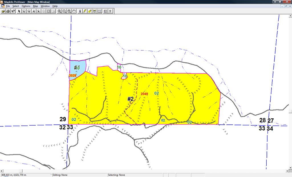
6 Once the user is in the Tract Listing screen, one click of the Open Map button will open MapInfo ProViewer with a map centered on the highlighted tract.
7

8 Basic MapInfo tools are available to the user including the information tool. Hotlinks also are functional.
9 1) Create a workspace (or workspaces) in MIPro with the desired characteristics. 2) Create 2 columns for x and y values for the Ownership table and populate with the values from the table s native projection. 3) Export Ownership table as a delimited ASCII file. 4) Edit workspace(s) created in step 1 above to create variables for Visual Basic.
10 !Workspace!Version 800!Charset WindowsLatin1 Open Table "N:\Shared Folders\GIS & Lands Management\Proviewer Data\MasterFiles\MAJORRDS" As MAJORRDS Interactive Open various other tables, the text for these lines won t fit on this slide! Open Table "N:\Shared Folders\GIS & Lands Management\Proviewer Data\starter data\or_gis\plssect" As PLSSECT Interactive Map From Timber_Text,Access_Control,Bridge,Corner_text,Proposedroads,Ridge_Lines, Property_Line,Unit_Text,Stands,Structures,Water,Utility_Line, WaterBuf,Roads,Tracts,MAJORRDS,Section_Line,HarvestUnits,PLSSECT Position ( , ) Units "in" Width Units "in" Height Units "in" Set Window FrontWindow() ScrollBars On Autoscroll On Set Map CoordSys Earth Projection 8, 62, "m", -123, 0, , , 0 Center ( , ) Zoom 7503 Units "ft" Preserve Zoom Display Position Distance Units "ft" Area Units "acre" XY Units "m"
11 !Workspace!Version 800!Charset WindowsLatin1 Close All Interactive Open Table "N:\Shared Folders\GIS & Lands Management\Proviewer Data\MasterFiles\MAJORRDS" As MAJORRDS Interactive Open various other tables, the text for these lines won t fit on this slide! Open Table "N:\Shared Folders\GIS & Lands Management\Proviewer Data\MasterFiles\Stands" As Stands Interactive Map From Timber_Text,Access_Control,Bridge,Corner_text,Proposedroads,Ridge_Lines, Property_Line,Unit_Text,Stands,Structures,Water,Utility_Line, WaterBuf,Roads,Tracts,MAJORRDS,Section_Line,HarvestUnits Position ( , ) Units "in" Width Units "in" Height Units "in" Set Window FrontWindow() ScrollBars On Autoscroll On Set Map CoordSys Earth Projection 8, 62, "m", -123, 0, , , 0 Center ( XCoord,YCoord ) Zoom 7503 Units "ft" Preserve Zoom Display Position Distance Units "ft" Area Units "acre" XY Units "m"

12 !Workspace!Version 800!Charset WindowsLatin1 Close All Interactive Open Table "N:\Shared Folders\GIS & Lands Management\Proviewer Data\MasterFiles\MAJORRDS" As MAJORRDS Interactive Without this line each time the open map routine runs, a new copy of ProViewer will open rather than clearing the tables out and opening a new workspace Open various other tables, the text for these lines won t fit on this slide! Open Table "N:\Shared Folders\GIS & Lands Management\Proviewer Data\MasterFiles\Stands" As Stands Interactive
13 Set Map CoordSys Earth Projection 8, 62, "m", -123, 0, , , 0 Center (XCoord,YCoord ) Zoom 7503 Units "ft" Preserve Zoom Display Position Distance Units "ft" Area Units "acre" XY Units "m" These are the Map Center variables that will be replaced with actual coordinates depending on the user s highlighted tract prior to selecting the open map button.
14 1) The program reads ID number for highlighted tract. The open map routine commences and looks at the ID number of the highlighted tract.
15 2) The program opens a copy of the workspace template. 3) The program looks up x & y coordinates in the spreadsheet based upon ID number of highlighted tract and substitutes for variables in workspace template. TractID Tract Number X Y Bailey Baker 1& Baldy Barker Barlow Bartholomew Baxter Beck Bennett Butte/Leep Benson Complex Berglund
16 Set Map CoordSys Earth Projection 8, 62, "m", -123, 0, , , 0 Center ( , ) Zoom 7503 Units "ft" Preserve Zoom Display Position Distance Units "ft" Area Units "acre" XY Units "m" 4) The program then looks at the file association for.wor, launches ProViewer and loads the modified workspace.
17 Private Sub cmdopenmap_click() On Error GoTo errorhandle: Dim i, intkey As Integer Dim strx, stry As String Dim strfullpath As String Dim straccount, strname As String Define variables Dim conn As New ADODB.Connection Dim rscsv As New ADODB.Recordset Dim rscurrentpc As New ADODB.Recordset intkey = Nz(Me.tblTract1_subform.Controls("KEYField"), 0) If intkey = 0 Then MsgBox "No Tract Selected!" Exit Sub End If straccount = modtract.returnaccount(intkey) strname = modtract.returnname(intkey)
18 If Not Dir("N:\", vbdirectory) = vbnullstring Then conn.open "DRIVER={Microsoft Text Driver (*.txt; *.csv)};" & _ "DBQ=N:\Apps\Proviewer\;", "", "" rscsv.open "select * from [Tracts#csv] where Tract_Number = " & straccount, conn, adopenstatic, _ adlockreadonly, adcmdtext strx = rscsv("x") stry = rscsv("y") rscsv.close conn.close '************************************************************** 'Copy the template file to TEMP Create new FileCopy "N:\Apps\Proviewer\Harvest_Plan.wor", temporary "N:\Apps\Proviewer\TEMP\" & workspace for modwindowsapiroutines.ap_getusername & ".wor" current user.
19 'Replace X then replace Y Replace modfileoperations.replacetextinstaticfile variables with "N:\Apps\Proviewer\TEMP\" & coordinates modwindowsapiroutines.ap_getusername & ".wor", "XCoord", CStr(strX) modfileoperations.replacetextinstaticfile "N:\Apps\Proviewer\TEMP\" & modwindowsapiroutines.ap_getusername & ".wor", "YCoord", CStr(strY) 'pause a moment this takes a bit for some reason For i = 1 To 4000 Next i 'Open the final workspace strfullpath = "N:\Apps\Proviewer\TEMP\" & modwindowsapiroutines.ap_getusername & ".wor" 'modfileoperations.fileexecute "N:\Apps\Proviewer\TEMP\" & modwindowsapiroutines.ap_getusername & ".wor" modfileoperations.fileexecute strfullpath Launch ProViewer with the final workspace
20 Else MsgBox "Drive not mapped" Exit Sub End If Error trapping errorhandle: If Err.Number = 3021 Then MsgBox "There is not a coordinate entry for the tract with Account ID " & straccount & ". The tract name is " & strname & vbcrlf & vbcrlf & " ERROR:" & Err.Number End Sub

21
22 1) Download and install ProViewer on each computer that you want to access your GIS data. 2) Store the tables and workspaces on a single common computer (preferably a server). 3) Create custom workspaces for as many map types that you want. 4) Edit workspaces as needed in a text editor to make certain the full path to each table is spelled out. 5) Train your users in the use of ProViewer.
23 Open workspace in a text editor to check for full path in open table statements!workspace!version 750!Charset WindowsLatin1 Open Table "Roads" As Roads Interactive Open Table "Roads_nonLRT" As Roads_nonLRT Interactive Open Table "Property_Line" As Property_Line Interactive Open Table "C:\2005 OR Photos\douglas_east2005.TAB" As douglas_east2005 Interactive Open Table "C:\MapInfo\Contours\NValleyNAD27_ZFT_contour" As NValleyNAD27_ZFT_contour Interactive Open Table "C:\MapInfo\neighbors\neighborlands" As neighborlands Interactive Open Table "Tracts" As Tracts Interactive Open Table "TOWNS" As TOWNS Interactive Open Table "HiWays" As HiWays Interactive Open Table "MAJORRDS" As MAJORRDS Interactive Open Table "C:\MapInfo\starter data\or_gis\orcounty" As ORCOUNTY Interactive Open Table "C:\MapInfo\starter data\or_gis\plssect" As PLSSECT Interactive Open Table "WaterBuf" As WaterBuf Interactive Open Table "Water" As Water Interactive Open Table "Water_Text" As Water_Text Interactive
24 Open Table "N:\Shared Folders\GIS & Lands Management\Proviewer Data\MasterFiles\MAJORRDS" As MAJORRDS Interactive Open Table "N:\Shared Folders\GIS & Lands Management\Proviewer Data\MasterFiles\Property_Line" As Property_Line Interactive Open Table "N:\Shared Folders\GIS & Lands Management\Proviewer Data\MasterFiles\Roads" As Roads Interactive Open Table "N:\Shared Folders\GIS & Lands Management\Proviewer Data\MasterFiles\Tracts" As Tracts Interactive Open Table "N:\Shared Folders\GIS & Lands Management\Proviewer Data\MasterFiles\Unit_Text" As Unit_Text Interactive Open Table "N:\Shared Folders\GIS & Lands Management\Proviewer Data\MasterFiles\Utility_Line" As Utility_Line Interactive Open Table "N:\Shared Folders\GIS & Lands Management\Proviewer Data\MasterFiles\Water" As Water Interactive Open Table "N:\Shared Folders\GIS & Lands Management\Proviewer Data\MasterFiles\WaterBuf" As WaterBuf Interactive Open Table "N:\Shared Folders\GIS & Lands Management\Proviewer Data\MasterFiles\HarvestUnits" As HarvestUnits Interactive Open Table "N:\Shared Folders\GIS & Lands Management\Proviewer Data\MasterFiles\Corner_text" As Corner_text Interactive

25 You will need to navigate to the folder that holds your workspaces the first time you use ProViewer. Subsequently, Proviewer will always look here first when the user chooses to open a workspace or table. (Note:ProViewer will open each table in a new map window if your user attempts to open individual tables) Careful crafting of the workspace will give your users maps that are useful. It is essential to gather sufficient input and also request feedback to optimize the workspaces. A few examples follow but the possibilities are virtually endless.

26


27 Show/Hide Legend option available to user

28

29 ? MapInfo ProViewer has made it possible for me to put the information in our GIS into the hands of many more users in our organization. The program is simple to use and cost effective. I even have a few users who use it in the field on their laptops. Maximize access to GIS data in your organization with MapInfo ProViewer.
MapInfo ProViewer 11.0 USER GUIDE
 MapInfo ProViewer 11.0 USER GUIDE Information in this document is subject to change without notice and does not represent a commitment on the part of the vendor or its representatives. No part of this
v SMS 13.0 Tutorial GIS P Prerequisites Time Requirements Objectives
 v. 13.0 SMS 13.0 Tutorial Objectives This tutorial demonstrates how to import data, visualize it, and convert it into SMS coverage data that could be used to build a numeric model. This tutorial will instruct
A Back-End Link Checker for Your Access Database
 A Back-End for Your Access Database Published: 30 September 2018 Author: Martin Green Screenshots: Access 2016, Windows 10 For Access Versions: 2007, 2010, 2013, 2016 Working with Split Databases When
Microsoft Excel 2016 Level 1
 Microsoft Excel 2016 Level 1 One Day Course Course Description You have basic computer skills such as using a mouse, navigating through windows, and surfing the Internet. You have also used paper-based
v SMS 12.3 Tutorial GIS P Prerequisites Time Requirements Objectives
 v. 12.3 SMS 12.3 Tutorial Objectives This tutorial demonstrates how to import data, visualize it, and convert it into SMS coverage data that could be used to build a numeric model. This tutorial will instruct
The City of Huntsville, Texas GIS Mapping System
 The City of Huntsville, Texas GIS Mapping System Author: Huntsville, Texas GIS Division GIS DATA & MAP DISCLAIMER: The City of Huntsville, Texas shall not be held liable for improper or incorrect use of
How to modify convert task to use variable value from source file in output file name
 Page 1 of 6 How to modify convert task to use variable value from source file in output file name The default SolidWorks convert task add-in does not have support for extracting variable values from the
PlaceMap. Accommodation. Slide 1
 PlaceMap for Accommodation Slide 1 PlaceMap Using the power of Google Earth to store and display all of your spatial data in a much more dynamic way Google Earth is a free software program that lets you
Juniata County, Pennsylvania
 GIS Parcel Viewer Web Mapping Application Functional Documentation June 21, 2017 Juniata County, Pennsylvania Presented by www.worldviewsolutions.com (804) 767-1870 (phone) (804) 545-0792 (fax) 115 South
Appendix 2: Random Plots Workbook: Unstratified Sample
 Appendix 2: Random Plots Workbook: Unstratified Sample These instructions will help users of all skill levels create a random sample of i-tree Eco plot centers, plot areas, and the associated i-tree Eco-required
Name: Date: June 27th, 2011 GIS Boot Camps For Educators Lecture_3
 Name: Date: June 27th, 2011 GIS Boot Camps For Educators Lecture_3 Practical: Creating and Editing Shapefiles Using Straight, AutoComplete and Cut Polygon Tools Use ArcCatalog to copy data files from:
Getting Started with Microsoft Office 2013
 Getting Started with Microsoft Office 2013 Objectives Understand Office Professional Plus 2013 Start an Office app Identify common screen elements in an Office app Use the Ribbon and zoom controls 2 Objectives
v SMS 11.1 Tutorial GIS Requirements GIS Module Map Module ArcGis (Optional) Time minutes Prerequisites None Objectives
 Time minutes Prerequisites None Objectives") v. 11.1 SMS 11.1 Tutorial GIS Objectives This tutorial demonstrates how you can read in GIS data, visualize it, and convert it into SMS coverage data that could be used to build a numeric model. We will
v. 11.1 SMS 11.1 Tutorial GIS Objectives This tutorial demonstrates how you can read in GIS data, visualize it, and convert it into SMS coverage data that could be used to build a numeric model. We will
Introduction to Google Earth Tutorial Haiti. 3/15/2011. Tufts GIS Center. Data Exploration
 Introduction to Google Earth Tutorial Haiti. 3/15/2011. Tufts GIS Center. Data Exploration 1. Open Google Earth 2. On the left you will see a navigation pane with 3 sections: Search, Places and Layers.
Microsoft Excel 2010 Level 1
 Microsoft Excel 2010 Level 1 One Day Course Course Description You have basic computer skills such as using a mouse, navigating through windows, and surfing the Internet. You have also used paper-based
City of La Crosse Online Mapping Website Help Document
 City of La Crosse Online Mapping Website Help Document This document was created to assist in using the new City of La Crosse online mapping sites. When the website is first opened, a map showing the City
Create engaging demonstrations, simulations and evaluations with Adobe Captivate. Creating from a PowerPoint. Importing a presentation
 Creating from a PowerPoint Create engaging demonstrations, simulations and evaluations with Adobe Captivate Preparation Set screen resolution to 1024 X 768 Launch Internet Explorer Turn off browser pop-up
Manual Physical Inventory Upload Created on 3/17/2017 7:37:00 AM
 Created on 3/17/2017 7:37:00 AM Table of Contents... 1 Page ii Procedure After completing this topic, you will be able to manually upload physical inventory. Navigation: Microsoft Excel > New Workbook
INTRODUCTION TO GIS WORKSHOP EXERCISE
 111 Mulford Hall, College of Natural Resources, UC Berkeley (510) 643-4539 INTRODUCTION TO GIS WORKSHOP EXERCISE This exercise is a survey of some GIS and spatial analysis tools for ecological and natural
US Geo-Explorer User s Guide. Web:
 US Geo-Explorer User s Guide Web: http://usgeoexplorer.org Updated on October 26, 2016 TABLE OF CONTENTS Introduction... 3 1. System Interface... 5 2. Administrative Unit... 7 2.1 Region Selection... 7
Step 3 Step 4. Step 8. Step 9
 This is an excerpt from Exercise 10, Scaled Output and the Layout Window, of the course manual provided for the McElhanney course MapInfo Professional and Encom Discover Mineral Exploration Module 1. Scaled
MapXpress Help Guide. 282 Main Street Ext. - C2 Middletown, CT
 MapXpress Help Guide 282 Main Street Ext. - C2 Middletown, CT 06457 203 404-7129 Table of Contents 1... Navigation Tools 2... Map Layers: Turning On and Off Data Layers 3... Searching By Name, Address,
Intro to GIS (requirements: basic Windows computer skills and a flash drive)
") Introduction to GIS Intro to GIS (requirements: basic Windows computer skills and a flash drive) Part 1. What is GIS. 1. System: hardware (computers, devices), software (proprietary or free), people. 2.
Introduction to GIS Intro to GIS (requirements: basic Windows computer skills and a flash drive) Part 1. What is GIS. 1. System: hardware (computers, devices), software (proprietary or free), people. 2.
Tutorial for Lane County Mapping Applications
 Tutorial for Lane County Mapping Applications Contents Overview... 2 Tools... 2 Navigation Tools... 3 Display Tools... 5 Information Tools... 6 Sharing Tools... 7 Common Tasks... 9 Identify or Show Data
Solar Campaign Google Guide. PART 1 Google Drive
 Solar Campaign Google Guide This guide assumes your team has already retrieved its template Solar Campaign folder from Vital Communities and shared it with the entire volunteer team on Google Drive. To
User Guide MapRoad 2.3 Install Guide Windows 7
 User Guide MapRoad 2.3 Install Guide Windows 7 Purpose of this Document The purpose of this document is to fully describe the installation of the modules associated with MapRoad 2.3 in a window 7 environment.
v SMS 12.2 Tutorial GIS Requirements GIS Module Map Module ArcGis (Optional) Time minutes Prerequisites None Objectives
 Time minutes Prerequisites None Objectives") v. 12.2 SMS 12.2 Tutorial Objectives This tutorial demonstrates how to read in data, visualize it, and convert it into SMS coverage data that could be used to build a numeric model. This tutorial will
v. 12.2 SMS 12.2 Tutorial Objectives This tutorial demonstrates how to read in data, visualize it, and convert it into SMS coverage data that could be used to build a numeric model. This tutorial will
INTRODUCTION TO MAPINFO/DISCOVER SHORT COURSE PROPOSAL
 INTRODUCTION TO MAPINFO/DISCOVER SHORT COURSE PROPOSAL Course Title to MapInfo Professional/Discover for Geologists Course Description Utilizing MapInfo Professional and Encom Discover software, the course
Hands-on GIS Project Watershed land use changes Smart Growth?
 Hands-on GIS Project Watershed land use changes 1995 2007 Smart Growth? Introduction New Jersey smart growth strategies aim at growing communities in a way that preserves open spaces, minimizes pollution
v GMS 10.0 Tutorial MODFLOW Transient Calibration Calibrating transient MODFLOW models
 v. 10.0 GMS 10.0 Tutorial MODFLOW Transient Calibration Calibrating transient MODFLOW models Objectives GMS provides a powerful suite of tools for inputting and managing transient data. These tools allow
Introduction to SAGA GIS
 GIS Tutorial ID: IGET_RS_001 This tutorial has been developed by BVIEER as part of the IGET web portal intended to provide easy access to geospatial education. This tutorial is released under the Creative
P6 Professional Reporting Guide Version 18
 P6 Professional Reporting Guide Version 18 August 2018 Contents About the P6 Professional Reporting Guide... 7 Producing Reports and Graphics... 9 Report Basics... 9 Reporting features... 9 Report Wizard...
Highway Performance Monitoring System
 Highway Performance Monitoring System Version 1.0 June 2011 Quick Start Guide for Version 8.0 Federal Highway Administration Table of Contents Chapter 1 Introduction... 1 Chapter 2 HPMS Workflow... 2 Chapter
Excel Macro Runtime Error Code 1004 Saveas Of Object _workbook Failed
 Excel Macro Runtime Error Code 1004 Saveas Of Object _workbook Failed The code that follows has been courtesy of this forum and the extensive help i received from everyone. But after an Runtime Error '1004'
GPS to GIS Tutorial Exploration of Native Plants
 Grossmont College Introduction to GIScience NAME: Instructors: Curran & Goodman 1 GPS to GIS Tutorial Exploration of Native Plants 1. Create a folder on your USB drive titled: GPS1 2. Using your GPS receiver,
Ted MacKinnon Directed Research Applications November 2003
 Ted MacKinnon Directed Research Applications November 2003 29 ArcPad combines both mobile mapping and geographic information system (GIS) technology together. It also provides database access, mapping,
Exporting Data Importing Data
 How To Guide Exporting Data Importing Data Wiztec Business Suite & WizHR 5 i Table Of Contents Table Of Contents Imports & Exports...1 Export Data...1 A. Exporting Data from One Screen...1 B. Exporting
Release Notes
 CONTENTS PAGE ipoint Publisher... ipoint Viewer... Search & Report imine Query Groups... 5 Results Panel Redesigned... 6 Default Criteria Entries... 7 Merge Results as Union (OR) or Intersection (AND)...
Checkbox Quick Start Guide
 Checkbox 5.0 - Quick Start Guide This How-To Guide will guide you though the process of creating a survey and adding a survey item to a page. Contents: - Log-In - How to create a survey - How to add/change
Assistive Technology Training Software Guide
 Assistive Technology Training Software Guide 1 Contents 1. Getting Started 1.1 Starting a new project 4 1.2 The Notetaker window layout 5 2. Importing to the Images Pane 2.1 Importing slides (from PowerPoint)
TIME TO GET ORGANIZED!
 This cheat sheet will get you on the fast track to understanding the main features of setting up your account. We will review creating groups, user-defined fields and importing your contacts into your
Map Library ArcView Version 1 02/20/03 Page 1 of 12. ArcView GIS
 Map Library ArcView Version 1 02/20/03 Page 1 of 12 1. Introduction 1 ArcView GIS ArcView is the most popular desktop GIS analysis and map presentation software package.. With ArcView GIS you can create
1. Open the New American FactFinder using this link:
 Exercises for Mapping and Using US Census Data MIT GIS Services, IAP 2012 More information, including a comparison of tools available through the MIT Libraries, can be found at: http://libraries.mit.edu/guides/types/census/tools-overview.html
World Premium Points of Interest Getting Started Guide
 World Premium Points of Interest Getting Started Guide Version: 0.1 1 Table of Contents INTRODUCTION... 3 1. Preface... 3 2. Data Characteristics... 3 3. Loading the data into RDMS Databases... 3 Oracle...
v SMS 12.1 Tutorial GIS Requirements GIS Module Map Module ArcGis (Optional) Time minutes Prerequisites None Objectives
 Time minutes Prerequisites None Objectives") v. 12.1 SMS 12.1 Tutorial Objectives This tutorial demonstrates how to read in data, visualize it, and convert it into SMS coverage data that could be used to build a numeric model. This tutorial will
v. 12.1 SMS 12.1 Tutorial Objectives This tutorial demonstrates how to read in data, visualize it, and convert it into SMS coverage data that could be used to build a numeric model. This tutorial will
StormWISE Software Documentation - Version 1.0 August, A. Stormwise_Distribution executable programs and example data files
 StormWISE Software Documentation - Version 1.0 August, 2007 1. Contents of Installed Package A. Stormwise_Distribution executable programs and example data files 1. BMPFIT a. AMPL run, model, and data
- Hold down the 'Shift' key and click and drag the mouse to create a red box which will zoom to that area when released.
 Basic navigation and zoom: To Pan around the map: - Click anywhere on the map and hold the button down until 4 directional arrows appear which will then allow the mouse to be moved in any direction panning
KDHE Watershed Management Web Map Editor Standard Operating Procedures (SOP) A. How to get Watershed Assignment? a. View Watershed Status
 A. How to get Watershed Assignment? a. View Watershed Status") KDHE Watershed Management Web Map Editor Standard Operating Procedures (SOP) A. How to get Watershed Assignment? a. View Watershed Status B. How to prepare web map for editing. a. Change visible Layers
KDHE Watershed Management Web Map Editor Standard Operating Procedures (SOP) A. How to get Watershed Assignment? a. View Watershed Status B. How to prepare web map for editing. a. Change visible Layers
seminar learning system Seminar Author and Learning System are products of Information Transfer LLP.
 seminar learning system Seminar Author and Learning System are products of Information Transfer LLP. Burleigh House 15 Newmarket Road Cambridge UK CB5 8EG E-mail: support@seminar.co.uk Phone: +44 (0)1223
HMH Leadership Form (Leader Guide)
") b a a b c Overview: Leadership Evaluation Form Getting Started: On the Home Page, you ll see a To-Do tile for any modules that have pending tasks assigned to you. Either (a) Click on the hyperlink to navigate
b a a b c Overview: Leadership Evaluation Form Getting Started: On the Home Page, you ll see a To-Do tile for any modules that have pending tasks assigned to you. Either (a) Click on the hyperlink to navigate
Using HEC-RAS and HEC-GeoRAS for River Modeling Adapted by E. Maurer, using an exercise by V. Merwade, Purdue Univ.
 Introduction Using HEC-RAS and HEC-GeoRAS for River Modeling Adapted by E. Maurer, using an exercise by V. Merwade, Purdue Univ. This tutorial uses the output from HEC_GeoRAS from a prior exercise as input
Getting Started with MapInfo Professional Hands On Session 1D
 In this session, the following topics will be covered: Open a DBF file Create Points Geocode to 5 digit ZIPCodes Use Query > Select Use the Select Tools Create a Thematic Map The Layout Window MapWorld
Marketing to Customers
 A Digital Cookie site isn t any good without customers! Learn how you can: Enter customer information Send marketing emails On the Digital Cookie dashboard, click the Customers tab.. The Customers page
Data Assembling Topics:
 Topics: 1. GPX to Shape file 2. Data conversion with FME 3. Create a polygon feature 4. Merging /Appending data into a new dataset 5. Reproject data from one coordinate system to another 6. Data clipping
The design and implementation of UML-based students information management system
 The design and implementation of UML-based students information management system Abstract Yunli Cheng 1, a, ChuanQin Li 2, b 1 Guangzhou Nanyang Polytechnic, Guangzhou 510925, China 2 Guangzhou Huaxia
TB-2 The Universal Text Trade Database File Format
 TradeSim Advanced Trading Simulator and Back Tester Technical Brief 2 The Universal Text Trade Database File Format TradeSim Professional Edition TradeSim Enterprise Edition Last Update 29 March 2007 Page
Getting Started. Ohm Portal. v2_ec01b38. Buddy Platform, Limited Ltd.
 Getting Started Ohm Portal v2_ec01b38 Buddy Platform, Limited Ltd. GU/US/18/09 Ohm Portal Get Started Guide Workspace Basics Workspace Basics Navigation Hierarchy An Organization is the top level in the
Table of Contents. Benefits of the Dealer Account...1. Creating a Dealer Account...1. Dealer Account Settings...3. Registering a System...
 Dealer Access Table of Contents Benefits of the Dealer Account...1 Creating a Dealer Account...1 Dealer Account Settings...3 Registering a System...4 Virtual Editor...6 File Explorer...7 System Settings...8
Mapping 2001 Census Data Using ArcView 3.3
 Mapping 2001 Census Data Using ArcView 3.3 These procedures outline: 1. Mapping a theme (making a map) 2. Preparing the layout for printing and exporting the map into various file formats. In order to
Marketing to Customers
 A Digital Cookie site isn t any good without customers! Learn how you can: Enter customer information Send marketing emails On the Digital Cookie dashboard, click the Customers tab.. The Customers page
Oracle General Navigation Overview
 Oracle 11.5.9 General Navigation Overview 1 Logging On to Oracle Applications You may access Oracle, by logging onto the ATC Applications Login System Status page located at www.atc.caltech.edu/support/index.php
Business Insight Authoring
 Business Insight Authoring Getting Started Guide ImageNow Version: 6.7.x Written by: Product Documentation, R&D Date: August 2016 2014 Perceptive Software. All rights reserved CaptureNow, ImageNow, Interact,
This tutorial shows how to extract longitudinal profiles using ArcMap 10.1 and how to plot them with R, an open-source software.
 JESSE S. HILL 2013 UNC-CH This tutorial shows how to extract longitudinal profiles using ArcMap 10.1 and how to plot them with R, an open-source software. R is freely available at: cran.us.r-project.org/
CMLS Technology Training Course Descriptions Updated Dec. 12, 2009
 CMLS Technology Training Course Descriptions Updated Dec. 12, 2009 Basic Excel Prerequisite: Introduction to Computers or equivalent experience Learn how to build a spreadsheet to track your business.
HEC-RAS 2D Flood Modelling Tutorial
 HEC-RAS 2D Flood Modelling Tutorial Civil Site Design and HECRAS 2D Flood Modelling HECRAS version 5 and later includes functionality to analyse water flows moving across a surface. this is known as 2D
Instructions: Website Employee Orientation Instructions
 Instructions: Website Employee Orientation Instructions 1. Presentation Security: a. Current Password: Enter the current password provided to you. (Case sensitive). i. If you have forgotten the password
The purpose of this tutorial is to introduce you to the Construct 2 program. First, you will be told where the software is located on the computer
 Learning Targets: Students will be introduced to industry recognized game development software Students will learn how to navigate within the software Students will learn the basics on how to use Construct
Enterprise Application Systems
 INFORMATION TECHNOLOGY Enterprise Application Systems Argos Report Viewer Guide Mt. San Antonio College Information Technology 1100 North Grand Avenue Building 23 Walnut, CA 91789 Help Desk 909.274.4357
Chapter 7. A Quick Tour of ArcGIS Pro
 Chapter 7 A Quick Tour of ArcGIS Pro Skills you will learn: This tutorial is intended to get you going using ArcGIS Pro, a new desktop application that is part of ArcGIS Desktop. A separate tutorial gives
User Guide Android App. Get the most out of the MapItFast app on your Android device with this user guide.
 User Guide Android App Get the most out of the MapItFast app on your Android device with this user guide. Last Updated: January 2017 Disclaimer The use of GPS devices, tablets and smartphones with MapItFast
CHAPTER TWO QUICKSTART. Projects and Session Files. Layers and Map Compositions CHAPTER TWO QUICKSTART 5
 CHAPTER TWO QUICKSTART Projects and Session Files Projects are an organizing concept throughout TerrSet. Projects contain folders which in turn contain files. Projects are similar to the concept of a geodatabase
Explore some of the new functionality in ArcMap 10
 Explore some of the new functionality in ArcMap 10 Scenario In this exercise, imagine you are a GIS analyst working for Old Dominion University. Construction will begin shortly on renovation of the new
Working with Attribute Data and Clipping Spatial Data. Determining Land Use and Ownership Patterns associated with Streams.
 GIS LAB 3 Working with Attribute Data and Clipping Spatial Data. Determining Land Use and Ownership Patterns associated with Streams. One of the primary goals of this course is to give you some hands-on
STUDENT PAGES GIS Tutorial Treasure in the Treasure State
 STUDENT PAGES GIS Tutorial Treasure in the Treasure State Copyright 2015 Bear Trust International GIS Tutorial 1 Exercise 1: Make a Hand Drawn Map of the School Yard and Playground Your teacher will provide
WinSLAMM v 10.2 User s Guide
 WinSLAMM v 10.2 User s Guide Batch Editor, Cost Analysis, pre Development Runoff Volume Calculation lationandand Creating a Model File from a Data File Batch Editor Running a Set of Files Batch Editor
SyncFirst Standard. Quick Start Guide User Guide Step-By-Step Guide
 SyncFirst Standard Quick Start Guide Step-By-Step Guide How to Use This Manual This manual contains the complete documentation set for the SyncFirst system. The SyncFirst documentation set consists of
Geography 281 Map Making with GIS Project Two: Map Design Issues in ArcMap
 Geography 281 Map Making with GIS Project Two: Map Design Issues in ArcMap This activity provides an introduction to the map design process. It takes you through a typical sequence from the initial decision
Release Notes. MapInfo Stratus Version 44. Contents: This document contains information about Pitney Bowes MapInfo Stratus Release 44.
 Location Intelligence MapInfo Stratus Version 44 This document contains information about Pitney Bowes MapInfo Stratus Release 44. Contents: What s new in MapInfo Stratus? What s new in Mobile Ready User
Release Notes RESOLVED NEW NEW
 3.5.92 Resolved a bug where pages in batch review were being saved by how they were selected and not how they appeared in the list. Resolved a bug with large PDF files not saving correctly through Drag
Dendrogram export options
 BioNumerics Tutorial: Dendrogram export options 1 Introduction In this tutorial, the export options of a dendrogram, displayed in the Dendrogram panel of the Comparison window is covered. This tutorial
-In windows explorer navigate to your Exercise_4 folder and right-click the DEC_10_SF1_P1.csv file and choose Open With > Notepad.
 BIOL 4460/5460 and GEOL 4460 Introduction to GIS LAB 4 MAKING A THEMATIC MAP This exercise is to show you how to create a map for printing. As you have seen in the lecture, maps can have different purposes
Introduction Accessing MICS Compiler Learning MICS Compiler CHAPTER 1: Searching for Data Surveys Indicators...
 Acknowledgement MICS Compiler is a web application that has been developed by UNICEF to provide access to Multiple Indicator Cluster Survey data. The system is built on DevInfo technology. 3 Contents Introduction...
WinFlexOne - Importer MHM Resources LLC
 WinFlexOne - Importer 2008 MHM Resources LLC WinFlexOne Importer - Employee 2 This module provides: Overview Log In Source File Importer Profile Download Activate Import Source File WinFlexOne Importer
Create Geomark in Google Earth Tutorial
 Create Geomark in Google Earth Tutorial General business example a potential applicant / user wants to create an area of interest that can be shared electronically to another party eg: another agency,
Flowlogic. User Manual Version GraphLogic: Developed by scientists, for scientists. Graphing and Statistical Analysis.
 Flowlogic Flow Cytometry Analysis Software Developed by scientists, for scientists User Manual Version 7.2.1 GraphLogic: Graphing and Statistical Analysis www.inivai.com TABLE OF CONTENTS GraphLogic Graphing
Each primary search has an auto-fill that will filter out results as the user continues to type.
 The Town of Farmville has recently requested a GIS parcel viewer and Timmons Group, based out of Richmond, VA, was selected to design and host this new website. This website allows users to look up parcel
ArcGIS Online workshop Shane Clarke John Sharrard. Central Oregon GIS User Group Meeting Bend, OR January 23, 2013
 ArcGIS Online workshop Shane Clarke John Sharrard Central Oregon GIS User Group Meeting Bend, OR January 23, 2013 Introduction i. What is ArcGIS Online? ii. Exploring ArcGIS Online Transform your Organization
User Guide. Version 2.0. Excel Spreadsheet to AutoCAD drawing Utility. Supports AutoCAD 2000 through Supports Excel 97, 2000, XP, 2003, 2007
 User Guide Spread2Cad Pro! Version 2.0 Excel Spreadsheet to AutoCAD drawing Utility Supports AutoCAD 2000 through 2007 Supports Excel 97, 2000, XP, 2003, 2007 Professional tools for productivity! 1 Bryon
Water Distribution System Modeling EPANET. Import an existing water distribution model and modify link and node parameters within WMS
 v. 10.1 WMS 10.1 Tutorial Water Distribution System Modeling EPANET Hydraulic Model Import an existing water distribution model and modify link and node parameters within WMS Objectives View an existing
15" HD Digital Photo Frame
 15" HD Digital Photo Frame Table of Contents 2 SAFETY INFORMATION...3 PACKAGE CONTENTS...3 FEATURES...4 REMOTE...5 QUICK START...6-7 PHOTO PLAYBACK...8-9 MUSIC PLAYBACK...10-11 MOVIE PLAYBACK...12-13 CALENDAR...14
SAVI Advanced The Basics
 SAVI Advanced The Basics Help Topics The Basics Getting Started System Requirements Getting Started Using SAVI Advanced Exploring the Data in SAVI Advanced Viewing Change Over Time Identifying Target Geographies
SME: Subject Matter Expert
 Microsoft SharePoint Workspace 2010 Connection Settings You can change communication settings for your workspace by using this feature. You can use this feature by selecting File > Info > Connection Settings.
Chapter 7. Geocoding in ArcGIS Desktop (ArcMap)
") Chapter 7 Geocoding in ArcGIS Desktop (ArcMap) Summary: In many cases, online geocoding services are all you will need to convert addresses and other location data into geographic data. When you have a
Chapter 7 Geocoding in ArcGIS Desktop (ArcMap) Summary: In many cases, online geocoding services are all you will need to convert addresses and other location data into geographic data. When you have a
3.2 Clipping Data Layers
 Advanced Data Management Clipping Data Layers 3.2.1 3.2 Clipping Data Layers Many times you will want to use a smaller part of a layer (like only the roads in one school district or town, not the whole
Working with Actuate e.reports
 Working with Actuate e.reports This documentation has been created for software version 11.0.5. It is also valid for subsequent software versions as long as no new document version is shipped with the
BDM (Xtender) 16.3 User Guide. How to Search, Retrieve, & Index Documents With BDM Web Access
 16.3 User Guide. How to Search, Retrieve, & Index Documents With BDM Web Access") BDM (Xtender) 16.3 User Guide How to Search, Retrieve, & Index Documents With BDM Web Access Information Technology Services (ITS) Table of Contents Chapter 1: Introduction... 4 BDM Overview of features...
BDM (Xtender) 16.3 User Guide How to Search, Retrieve, & Index Documents With BDM Web Access Information Technology Services (ITS) Table of Contents Chapter 1: Introduction... 4 BDM Overview of features...
Exercise 1: An Overview of ArcMap and ArcCatalog
 Exercise 1: An Overview of ArcMap and ArcCatalog Introduction: ArcGIS is an integrated collection of GIS software products for building a complete GIS. ArcGIS enables users to deploy GIS functionality
Financial Functions (all with subtypes: Normal, Stairs, Points, Height, Hollow, Colors, Marks, No Border except where indicated):
:") Financial Charting in TeeChart Pro TeeChart Pro has always been at the cutting edge of Financial Charting and the ActiveX v6 makes this very clear; with three distinct financial series and fourteen dedicated
Financial Charting in TeeChart Pro TeeChart Pro has always been at the cutting edge of Financial Charting and the ActiveX v6 makes this very clear; with three distinct financial series and fourteen dedicated
Exercise1: Make a print map of Africa
 Exercise1: Make a print map of Africa Step 1 Open an existing Arcview project Step 2 Choose which geographic features are displayed on a map Step 3 Zoom in to an area you re interested in. Step 4 Label
IS 320 Spring 96 Page 1 Exam 1. Please use your own paper to answer the following questions. Point values are shown in parentheses.
 IS 320 Spring 96 Page 1 Please use your own paper to answer the following questions. Point values are shown in parentheses. 1. (10) Consider the following segment of code: If txtansicode.text < "0" Or