Lower Mississippi Valley Joint Venture On-line Reforestation Tracking System (e-rts) e RTS. e-rts Manual Version 1.3.i
|
|
|
- Esther Floyd
- 5 years ago
- Views:
Transcription
1 Lower Mississippi Valley Joint Venture On-line Reforestation Tracking System (e-rts) e RTS e-rts Manual Version 1.3.i Edited by: Jeremy Shane White 6/28/2006
2 e-rts Manual Table of Contents User s Guide Welcome What is the e-rts? Welcome 3 What is reforestation? Welcome 3 What types of data does the e-rts track? Welcome 3 Who can access the e-rts? Welcome 4 How can the e-rts be used? Welcome 4 What else? Welcome 4 Quick Start Step 1 Creating and Transmitting Your Spatial Data Quick Start 1 Step 2 Preparing to Enter Your Reforestation Event Details Quick Start 1 Step 3 Recording Reforestation Event Details Quick Start 2 e-rts Web Pages Enter New Record e-rts Web Pages - 1 Review/Modify Existing Record e-rts Web Pages - 8 References Reference 1: GIS Scripts & Extensions (ArcView 3 & ArcGIS 8) a) Calculate Polygon Areas in Shapefile (ArcView 3) Reference 1 1 b) Calculate Polygon Areas in Shapefile (ArcGIS 8 or 9) Reference 1 3 c) Re-project Shapefile (ArcView 3, Projector! Extension) Reference 1 4 d) Re-project Shapefile (ArcView 3, Projection Utility Extension) Reference 1 5 e) Re-project Feature to geographic projection (ArcGIS 8 or 9) Reference 1 6 f) Calculate x, y Coordinates of a Polygon Centroid (ArcView 3) Reference 1 7 g) Calculate x, y Coordinates of a Polygon Centroid (ArcGIS 8 or 9) Reference 1 8 Reference 2: Datasheet Helpful Hints for Using Datasheet Reference 2 1 Blank Datasheet to Copy Reference 2 4 Welcome 2
3 Welcome to the on-line Reforestation Tracking System (e-rts) of the Lower Mississippi Valley Joint Venture (LMVJV). The e-rts is intended to serve as a central data repository for reforestation within the administrative boundary of the LMVJV Joint Venture as a service to Joint Venture partners. This manual is divided into two sections: a User s Guide and a References section. The User s Guide includes answers to common questions, a Quick Start tutorial, and illustrations of the e-rts Web Pages with helpful hints for users. The References section includes step-by-step directions to generate the area and centroid coordinates of reforestation polygons as well as an example of a datasheet template. Feedback and suggestions are welcomed and should be directed to Blaine Elliott (blaine_elliott@fws.gov) at the JV Office. Important Questions: What you need to know What is the e-rts? The e-rts is a more powerful, web-accessible version of the Joint Venture s previous Reforestation Tracking System designed to track data relative to reforestation efforts by partner and associated agencies within the Mississippi Alluvial Valley and West Gulf Coastal Plain. Its purpose is to provide foresters with an easy-to-use, centralized repository for reforestation information in a standardized format that can be used by land managers and planners to spatially detail land use change across the landscape and evaluate land management strategies over the long term. What is reforestation? "Reforestation," as defined for this database, is the re-establishment of a forested land use on areas that were previously converted from a forest to non-forest land practice (e.g., agriculture). This is also sometimes referred to as afforestation. This re-establishment of forest can be through active (tree planting) or passive (area allowed to proceed naturally through the stages of forest succession as a deliberate management decision) management. Only lands reforested in these manners are to be recorded in the e-rts. An active reforestation event is defined as a contiguous planting of trees that is unique to all other plantings either by time, space, site preparation or planting methods, agreement type, agreement duration, or mix of tree species planted. If plantings differ from each other in any of these characteristics, they must be tracked as separate reforestation events (i.e., entered as separate polygons and tabular records). A single reforestation event can be delivered under more than one signed agreement and be funded by more than one funding source. However, only one of any type of agreement can be recognized on a single reforestation event. In other words, if adjoining lands are planted in the same manner at the same time but partially under a 15-year CRP agreement and partially under a 10-year CRP agreement, two reforestation events must be entered into the RTS database. What types of data does the e-rts track? The e-rts is built on a relational database model and is capable of tracking multiple details for each reforestation event. The two primary types of data tracked are geospatial data and tabular data. Geospatial data is GIS-based data pertaining to the shape, location and juxtaposition of the reforestation event (i.e. a shapefile). Tabular information includes the administrative, pre-planting conditions, and specific planting details relevant to the reforestation event. Welcome 3
4 Who can enter / update data in the e-rts? Data entry is controlled; each partner agency or organization formally assigns data entry authority to specified individuals within each organization. Each person identified is assigned a unique User ID and Password by the RTS Data Base Manager. The data entered by these authorized personnel is available for review through report queries which can be accessed through the web site. How can the e-rts be used? The e-rts has been designed to be the principal reforestation database for all JV-partner and associated foresters and wildlife biologists. Tabular information is entered via streamlined web entry forms. Reforestation Events are recorded, reviewed, and updated via the Internet. Geospatial information becomes a component of the database in a multi-step process (See Quick Start, Step 2). Besides data entry capabilities, standard reports, ArcIMS mapping and customized query capabilities are being built. As Joint Venture partners define their needs regarding report output, more standard reports will be placed on-line. The more input we get from users, the more we ll be able to serve your reforestation tracking needs via the e-rts. What else do I need to know before I enter data? Connection speeds to the Internet vary; thus, monitor refresh rates vary. Refresh time is the amount of time the users screen takes to redraw after a selection on a web page has been made. Average refresh times range from 2-5 seconds. If your screen goes blank after you make a selection, don t panic; just allow the screen time to refresh itself. If you use Microsoft Outlook as your program, you may experience a slower than normal refresh rate and may lose data if you receive an message notification during data entry. Log out of Outlook before you log on to e-rts. When entering tabular data, do not use the BACK button on your browser s interface. Doing so will mess up your data entry. Data modifications can be made using the MODIFY buttons on the Review Page, after data entry but prior to data submission (See e-rts Web Pages). Blaine Elliott JV GIS Applications Biologist MAV Joint Venture Office -- Vicksburg, MS blaine_elliott@fws.gov Welcome 4
5 Quick Start: Entering a New Reforestation Record The LMV Joint Venture Office has developed a relatively painless set of steps to record your reforestation event information into the comprehensive, permanent database. For each reforestation event create a polygon in your local geographic information system (GIS) and record the associated details (e.g., trees planted) about the event in the on-line Reforestation Tracking System (e-rts). Send Blaine Elliott (blaine_elliott@fws.gov) all of the files related to your shapefile containing the reforestation polygon(s). The spatial data and tabular data will be linked using the assigned RTS_ID. The spatial data will be added to the comprehensive Reforestation Tracking shapefile that will be available online to Joint Venture partners. Step 1: Creating and Transmitting Your Spatial Data Create the polygon for each reforestation event following the LMVJV Geomatics Network standards -- i.e., GIS data in units of decimal degrees, NAD83 datum, digitized at a map scale > 1:15,000. Be prepared to enter into e-rts the area (in acres) and centroid coordinates (in decimal degrees [latitude (Format: xx.xxxxx) and longitude (Format: -xx.xxxxx)]) for each polygon. (For helpful hints on using ESRI scripts and extensions to calculate area and determine the x, y location of a polygon centroid, see Reference 1.) shapefile (including all associated files; e.g.,.shp,.shx,.dbf, etc.) to blaine_elliott@fws.gov Step 2: Preparing to Enter your Reforestation Planting Details Besides the area and centroid data from Step 1, the e-rts requests typical tree planting details for each reforestation event (Table 1). Table 1. Planting details required for e-rts records Site Location Longitude of centroid (decimal degrees, NAD83) Latitude of centroid (decimal degrees, NAD83) Area (acres) Site Name used locally Site Code used locally State Field Contact Name (first, last, telephone number) Land Ownership Land Management (public or private) Management Agreement(s) Type Duration Funding Sources Reforestation Action (active or passive) Prior Landuse(s) (during the past 5 years) Landcover at time of site-prep or planting Site Preparation Activities Site Conditions at Time of Planting Ground cover Stem count of trees Date Planting At Site Was Completed Details on Trees Planted Species Planting Method Quantity of seedlings / Pounds of seed Seedling Quality (Good / Fair / Poor) Step 3 provides instructions on how to get on-line and login to the web-based e-rts application. We recommend you gather all of the information on the listed items before logging on. To assist with data collection, Reference 2 contains a datasheet template. Refer to e-rts Web Pages for an example of the data entry process. e-rts Quick Web Pages Start -- 11


6 Step 3: Recording Reforestation Event Details To record planting details login to e-rts from the LMVJV homepage ( (Figure 1). To enter new data or review/update existing records, enter the unique user name and password provided to you via the LMVJV office. Once logged into e-rts, enter all of the requested planting details for a single reforestation event/polygon. All data requested (unless otherwise specified) are required. Use of the browser s BACK button is strongly discouraged, because your entry for that reforestation record into the database will fail. When you click on the ACCEPT button on the Data Review page (See e-rts Web Page 6) the data you have entered will automatically be stored in the permanent RTS database housed in the LMVJV office. To make a hard copy of your data entry, print the Review page after you 1. Have checked your data entry and made any necessary modifications to the data 2. Have clicked the ACCEPT button, and 3. See, in the top right corner, the RTS ID number of the record just entered into the database. That s all you need to know to get started!!! Figure 1: Homepage of LMVJV office To access the geo-rts application, Point the cursor to the Monitoring tab, Slide the cursor down to Habitat Monitoring Program, Slide the cursor across to Reforestation Tracking System (RTS), and Click Click here to access the e-rts login page Quick Start 2


 and")

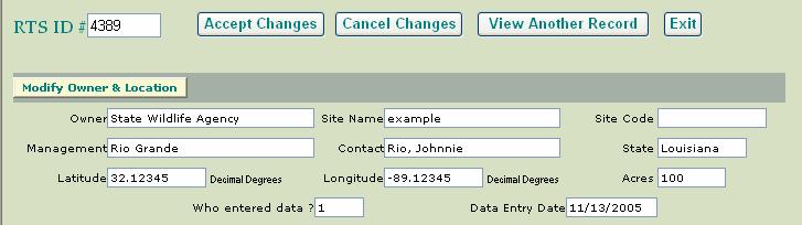
7 User Name and Password assigned by the RTS Database The user can only edit records he or she has entered See User Guide: References (f) and (g) for directions on how to determine these 100 e-rts Web Pages - 1


8 Organizations or individuals that provide funding or in-kind support for The purchase of planting stock Site preparation activities Tree planting e-rts Web Pages - 2


9 Hyperlink opens window containing definitions of site preparation actions e-rts Web Pages - 3


10 Click on the calendar icon Jan 1990 To change the year, click on the given year Set of 10 years rolls out to the right. Use top or bottom arrow to scroll. Select the correct year To change the month, click on the given month Jan 1985 Nov 1985 The list of months appears at the bottom of the calendar Select the correct month Select the correct day e-rts Web Pages - 4


11 Repeat Steps 1 4 until all of the tree species planted as bare-root seedlings at this site are entered into the table Indicate the condition the seedlings were in when planted Click the ADD button to enter the species into the table Select the tree species from drop down menu Type in the number of seedlings of this species planted at this site Seedling Quality includes seedling age, root collar diameter, water stress, presence of disease, quantity of viable roots, leaf quality and other factors that influence transplant mortality. If there is an error in one of the rows during data entry, click the Delete hyperlink for that row. It will remove the row from the table. Now, enter the correct data e-rts Web Pages - 5


12 Review the data for the record you just entered. Use the Modify buttons to access pages in the application that permit modification of the data, if you need to change your entry When the data is correct, click ACCEPT to enter the record into the database e-rts Web Pages - 6

13 The user can use the browser s PRINT functions to print this page for the office The application returns the RTS_ID# assigned by the database to the record. Record this number in the office file for future reference. e-rts Web Pages - 7


14 Directions to Modify Existing Records Click to review or update existing records Click on desired record s RTS ID Click on desired modify button e-rts Web Pages - 8


15 Click Return To Review after desired information is entered e-rts Web Pages - 9
16 Reference 1(a) Use the XTools extension (ArcView 3.x) to calculate the area of polygons in a shapefile with a geographic projection Set the View window properties How To: Select the View drop down menu Properties Map Units: Decimal Degrees Distance Units: (Whatever you prefer. Feet work well.) Make sure the XTools Extension is checked How To: Select the File drop down menu Extensions Check XTools Set the default XTools settings View/Change XTools Defaults XTools Question Answer a) Specify the map units of your data: Degrees b) Specify the desired output map units: Feet c) Specify the desired default View distance units: Feet d) Specify the desired units for area outputs: Acres e) Always convert overlay (CLIP, INTERSECT, etc.) output shapes to single part? No f) Always calculate Area, Perimeter, Acres (Hectares), Length? No g) Do NOT show View Properties and XTools Defaults when creating a new View. (uncheck) h) Do NOT show the XTools Defaults Dialog when the XTools Extension loads. (uncheck) i) Button: Set Projection Projection Properties window Standard Custom Standard Category: Projections of the United States Type: Albers Equal-Area (Conterminous U. S.) Button: OK Button: Save Defaults [Ignore Info window] Button: Close Add the polygon shapefile to the View How To: Select the View drop down menu Add theme e-rts Web Pages - 10 Reference 1-1
17 Calculate polygon acreage How To: Select the XTools drop down menu Calculate Area, Perimeter Select the correct theme Button: OK Insure that an acres field has been added to the attribute table of the theme How To: Make sure that the correct theme is Active Select the Theme drop down menu Select Table You should see that the following columns have been added to the theme s attribute table and have been populated with data. Area_Feet Perimeter_Feet Acres e-rts Web Pages - 11 Reference 1-2
18 Reference 1(b) Use the XTools extension (ArcGIS 8.x) or Field Calculator to calculate the area of polygons in a shapefile with a geographic projection (Xtools is no longer a free-ware option. ESRI now owns proprietary rights to the software extension and, therefore, requires a fee for usage. If you do not own Xtools, use the script instructions below). Using Xtools to calculate area in a polygon shapefile Once Xtools is installed, it is available in the Extensions menu To access, Select Tools, Extensions, Xtools Pro To display the Xtools Toolbar, Select View, Toolbars, Xtools Pro To calculate area for a polygon field, Select Xtools Pro drop-down menu, Table Operations, Calculate Area, Perimeter, Length, Acres, and Hectares Select the file for which you wish to calculate area Click OK If your table already contains fields for acres, etc., have Xtools recalculate. Click Yes to continue Xtools will automatically open and refine your table and close it for you when it is finished. Using the Field Calculator to update area for a polygon shapefile Add a field to the attribute table and call it Area How To: Right-click on the shapefile name in the Table of Contents and select Open Attribute Table In the attribute table window, left-click on the Options button and select Add Field Type: Double Precision: 0 (default) Scale: 0 (default) Start an edit session in ArcMap (Calculating a field is faster outside of an edit session, but you won't be able to undo the calculation.) In the attribute table window, right-click the header for the Area field and select Calculate Values In the window that opens, check the box next to the word Advanced In the text box that appears directly under pre-logic VBA script code, type the following VBA statement Dim dblarea as Double Dim parea as IArea Set parea = [shape] dblarea = parea.area Type the variable dblarea in the text box directly under Area = Click OK. e-rts Web Pages - 12 Reference 1-3
19 Reference 1(c) Use the ARCVIEW PROJECTOR! EXTENSION to re-project a shapefile to the geographic projection (units of decimal degrees (DD); NAD83) Define the View s Map Units How To: Select the View drop down menu Properties Map Units: (Select the shapefile s maps units from the drop down list. For example, the Map Units for a shapefile in UTM are meters) Make sure the Projector! Extension is checked How To: Select the File drop down menu Extensions Check Projector! In the View window, click on the Projector! Button Pop up window: Please select the input projection in the next dialog box Click OK Select the appropriate settings. How To: For example, for a shapefile in UTM Zone 15, NAD83, select the following Standard Category: UTM 1983 Type: Zone 15 Click OK Pop up window: Please pick output units: Select decimal degrees Click OK Pop up window: Recalculate area, perimeter and length fields (if present) using decimal degrees? Click No Pop up window: Add projected shapefile(s) as theme(s) to a view? Click No Using the browse capabilities in the next pop-up window, place the projected shapefile in the correct directory and name it appropriately. Click OK e-rts Web Reference Pages
20 Reference 1(d) Use the ARCVIEW PROJECTION UTILITY to re-project a shapefile to the geographic projection (units of decimal degrees (DD); NAD83) Make sure the Projection Utility Wizard Extension is turned on How To: Select the FILE drop down menu Extensions Check Projection Utility Wizard With the View window Active, access the ArcView Projection Utility (File DropDownMenu) ArcView Projection Utility STEP 1 Browse to the location of the shapefile to re-project and click Open Click Next ArcView Projection Utility STEP 2 Enter the current coordinate system of the shapefile to re-project If the datum of the current coordinate system is NAD27, make sure Show Advanced Options is checked, select the Datum tab and set Geographic Transformation to NAD_1927_To_NAD_1983_NADCON Click Next Pop-up window: Do you want to save the input information? Click Yes ArcView Projection Utility STEP 3 Select coordinate system for new shapefile Coordinate System Type: Geographic Name: GCS_WGS_1984 [4326] Units: Degree [9102] Click Next Pop-up window: Do you want to save the output information? Click Yes ArcView Projection Utility STEP 4 Select a location to save the new shapefile and give the new shapefile a name ArcView Projection Utility SUMMARY Verify the settings you selected Click Finish and WAIT for the Progress window to appear. It may take awhile. When processing is complete, click OK e-rts Web Reference Pages
21 Reference 1(e) Use the ArcToolbox Tools to re-project a feature to the geographic projection (Units of decimal degrees (DD); NAD 83) To Start: Click the ArcToolbox Data Management Tools Projections and Transformations Feature Project STEP 1: Input Dataset or Feature Class -Select the feature name from the dropdown menu, or browse to it by clicking on the folder icon. Note: For this example, the directions assume that the input feature is projected using NAD83. STEP 2: Output Dataset or Feature Class -Browse to the folder where you want to save the new feature. -Give it a name. Note: Consider including a reference to the projection and datum in the feature s name. STEP 3: Output Coordinate System -Click the text file button. -In the pop-up window click the Select button. -Click the Geographic folder. -Click the North American folder. -Browse until you find North American Datum 1983.prj specifically! -Click Add -Click OK STEP 4: Geographic Transformation * Since the input file used the same datum as the output file there is no need to select a method of geographic transformation for this reprojection. STEP 5: Review -Check the details -Click the OK button. Note: This new feature will appear in the view window over the original feature. This is because in Arc Map 8.x and above the software reprojects features on the fly. If you look at: Layers Properties Tab: Coordinate System Layers You will see the projection of each layer in the table of contents. e-rts Web Pages - 15 Reference 1-6
22 Reference 1(f) Calculate the x and y coordinates of polygon centroids using an ESRI script (ADDXYCOO.AVE) in ArcView GIS 3.x Open a new View and add the polygon shapefile for which you need centroids. To calculate centroids in decimal degree units, the shapefile projection must be geographic. Open a new Script window. HOW TO: Activate the Project window (If you can not see the Project window, minimize the View window) Click the SCRIPTS icon on the left of the Project window Click the NEW button at the top of the Project window Select SCRIPT drop down menu Select Load Text File Load ADDXYCOO.AVE into the Script window. HOW TO: Navigate to \esri\av_gis30\arcview\samples\scripts\ Select ADDXYCOO.AVE from the list Click OK Make ADDXYCOO.AVE usable in the View window HOW TO: Give the script a name Select SCRIPT drop down menu Select Properties Beside Name, type in Centroid Click OK Compile the script Select SCRIPT drop down menu Select Compile Attach the script to a new button in the View window Make the Project window active Select PROJECT drop down menu Select Customize Type: View Category: Buttons Click on the button labeled New Double-click on the Click property line in the Customize window Select Centroid from the SCRIPT MANAGER scroll down menu Click OK Double-click on the Icon property line in the Customize window Select BoxLargeDot from the ICON MANAGER scroll down menu Click OK Close the Customize window Close the Script window Use ADDXYCOO.AVE from the View window HOW TO: Make the View window Active Make Active the polygon shapefile for which you need the centroids calculated Click on the BoxLargeDot button e-rts Web Pages - 16 Reference 1-7
23 Reference 1(g) Calculate the x, y coordinates of the polygon centers using ArcGIS Make sure that the units of your shapefile are decimal degrees in NAD83. Open the attribute table of your shapefile. Add two new fields to the table. Label one of the new fields X (for longitude) and the other Y (for latitude). Type: Double Precision: 0 (leave as default) Scale: 0 (leave as default) Start an edit session. Calculating a field is faster outside of an edit session, but you won't be able to undo the calculation. Right-click on the header for the X field From the list of tools click Calculate Values Check the box next to the word Advanced Under pre-logic VBA script code, type (or cut and paste from User s Guide) the following VBA statement Dim dblx As Double Dim parea As IArea Set parea = [Shape] dblx = parea.centroid.x Type the variable dblx under X = Click OK The longitude of each polygon is calculated and stored in the X field. These values should be negative if you are working with data from the United States. Repeat the same process, using the following VBA statement, to fill in the Y coordinates Dim dbly As Double Dim parea As IArea Set parea = [Shape] dbly = parea.centroid.y Type the variable dbly under Y = Click OK Stop editing, saving your edits e-rts Web Pages - 17 Reference 1-8
24 Helpful Hints Regarding Use of the e-rts Data Sheet Data Entry Order The letters (Reference 2 2: A N) indicate the order that the data is entered into the e-rts Web Pages. Land Owner Options Public State Wildlife Agency National Wildlife Refuge Army Corps of Engineers Forest Service Other Private Agriculture Energy company Forest, industrial Forest, non-industrial Longitude & Latitude Longitude is negative because the MAV and WGCP are located in the western hemisphere. The maximum to minimum latitude range (north to south) is decimal degrees. The minimum to maximum longitude range (west to east) is decimal degrees. The x, y coordinates of the center of your reforestation polygon (i.e., the centroid) should fall within these limits. Landuse & Landcover The list of options provided for Landcover is the same as the list provided for Landuse with the addition of Fallow. The data QA/QC will check reforestation record entries to make sure that if Landcover is not Fallow, the entries for Landuse include the Landcover selected. Number of Tree Species Planted The number of rows in each of the Planting Event tables does not indicate the number of tree species that can be entered into the database for any one reforestation event. The number of rows in each table on the datasheet was limited by the number of lines that fit on the page. You may enter as many tree species per reforestation event as you like. List Additions If you have any additions to make to any of the lists of options (Land Owner, Land Management, Landuse/Landcover, Agreement, Funding, Site Preparation, or Trees), please contact Blaine Elliott (blaine_elliott@fws.gov). Reference
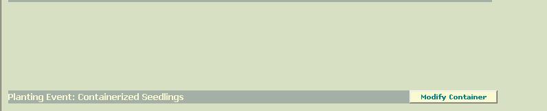
25 A e-rts Data Sheet Land Owner Site Name Site Code Land Management Field Contact State Latitude. Decimal degrees Longitude -. Decimal degrees Acres Once entered, Planting Action (Initial, Replant, or None (Natural Succession) cannot be changed E Landcover at time of site preparation or planting F Site left to Natural Succession? If Replant, what was the reason? True / False Complete replant Species augmentation If Planting Action = Replant, Landcover = Failed Reforestation and Years Fallow = 0 automatically, Natural Succession? = False automatically when planting is an Initial Planting or a Replant. Years Fallow Stem count augmentation Species and stem count augmentation Before site preparation or planting, what was the.. H % Groundcover 0 75 % % Tree Stems / Acre > 300 Record any site or weather conditions that might influence tree survival in this comment space. Comment I B J Date Planting Finished or Natural Succession Began K Site Prep to Plant Interval 0 3 months 4 6 months 7 12 months Agreement Duration Funding Site Preparation Landuse C G D Options listed on e-rts Web Pages 1 Options listed on e-rts Web Pages 2 Options listed on e-rts Web Pages months > 2 years Options listed on e-rts Web Pages 2 A duration of 200 means that the agreement is perpetual. If Planting Action = Replant, Landuse = Failed Reforestation automatically N Planting Event: Containerized Seedlings Planting Method Planting Contractor Spacing-X (ft) Spacing-Y (ft) Hand, staff Hand, contractor By tractor, staff By tractor, contractor Trees Planted as Containerized Seedlings Seedling Total Common Name Quality Planted Seedling Quality Options: Good Fair Poor Reference
26 L Planting Event: Bare-root Seedlings Planting Method Hand, staff Hand, contractor By tractor, staff By tractor, contractor Trees Planted as Bare-root Seedlings Seedling Total Common Name Quality Planted Planting Contractor Spacing-X (ft) Spacing-Y (ft) Seedling Quality Options: Good Fair Poor M Planting Event: Seeds (Acorns) Planting Method Hand, staff Hand, contractor By tractor, staff By tractor, contractor Aerial, staff Aerial, contractor Trees Planted as Seeds (Acorns) Common Name Pounds Planted [ #.#] Planting Contractor Spacing-X (ft) Spacing-Y (ft) Reference 2-3
27 e-rts Data Sheet Land Owner Site Name Site Code Land Management Field Contact State Latitude. Decimal degrees Longitude -. Decimal degrees Acres Once entered, Planting Action (Initial, Replant, or None (Natural Succession) cannot be changed Landcover at time of site preparation or planting Site left to Natural Succession? If Replant, what was the reason? True / False Complete replant Species augmentation If Planting Action = Replant, Landcover = Failed Reforestation and Years Fallow = 0 automatically, Natural Succession? = False automatically when planting is an Initial Planting or a Replant. Years Fallow Stem count augmentation Species and stem count augmentation Before site preparation or planting (if no prep occurred), what was the.. % Groundcover 0 75 % % Tree Stems / Acre > 300 Record any site or weather conditions that might influence tree survival in this comment space. Comment Date Planting Finished or Natural Succession Began Site Prep to Plant Interval 0 3 months 4 6 months 7 12 months Agreement Duration Funding Site Preparation Landuse months > 2 years A duration of 200 means that the agreement is perpetual. If Planting Action = Replant, Landuse = Failed Reforestation automatically Planting Event: Containerized Seedlings Hand, staff Hand, contractor Planting Method By tractor, staff By tractor, contractor Trees Planted as Containerized Seedlings Seedling Total Common Name Quality Planted Planting Contractor Spacing-X (ft) Spacing-Y (ft) Seedling Quality Options: Good Fair Poor Reference 2-4
28 Planting Event: Bare-root Seedlings Planting Method Hand, staff Hand, contractor By tractor, staff By tractor, contractor Trees Planted as Bare-root Seedlings Seedling Total Common Name Quality Planted Planting Contractor Spacing-X (ft) Spacing-Y (ft) Seedling Quality Options: Good Fair Poor Planting Event: Seeds (Acorns) Planting Method Planting Contractor Spacing-X (ft) Spacing-Y (ft) Hand, staff Hand, contractor By tractor, staff By tractor, contractor Aerial, staff Aerial, contractor Trees Planted as Seeds (Acorns) Common Name Pounds Planted [ #.#] Reference 2-5
Basic Tasks in ArcGIS 10.3.x
 Basic Tasks in ArcGIS 10.3.x This guide provides instructions for performing a few basic tasks in ArcGIS 10.3.1, such as adding data to a map document, viewing and changing coordinate system information,
Exercise 5: Import Tabular GPS Data and Digitizing
 Exercise 5: Import Tabular GPS Data and Digitizing You can create NEW GIS data layers by digitizing on screen with an aerial photograph or other image as a back-drop. You can also digitize using imported
Data Assembly, Part II. GIS Cyberinfrastructure Module Day 4
 Data Assembly, Part II GIS Cyberinfrastructure Module Day 4 Objectives Continuation of effective troubleshooting Create shapefiles for analysis with buffers, union, and dissolve functions Calculate polygon
This will display various panes in a window.
 Map Map projections in ArcMap can be a bit confusing, because the program often automatically reprojects data for display, and there are a ways to permanently project data to new data sets. This describes
v SMS 11.1 Tutorial GIS Requirements GIS Module Map Module ArcGis (Optional) Time minutes Prerequisites None Objectives
 Time minutes Prerequisites None Objectives") v. 11.1 SMS 11.1 Tutorial GIS Objectives This tutorial demonstrates how you can read in GIS data, visualize it, and convert it into SMS coverage data that could be used to build a numeric model. We will
v. 11.1 SMS 11.1 Tutorial GIS Objectives This tutorial demonstrates how you can read in GIS data, visualize it, and convert it into SMS coverage data that could be used to build a numeric model. We will
Exercise 4: Import Tabular GPS Data and Digitizing
 Exercise 4: Import Tabular GPS Data and Digitizing You can create NEW GIS data layers by digitizing on screen with an aerial photograph or other image as a back-drop. You can also digitize using imported
v SMS 12.1 Tutorial GIS Requirements GIS Module Map Module ArcGis (Optional) Time minutes Prerequisites None Objectives
 Time minutes Prerequisites None Objectives") v. 12.1 SMS 12.1 Tutorial Objectives This tutorial demonstrates how to read in data, visualize it, and convert it into SMS coverage data that could be used to build a numeric model. This tutorial will
v. 12.1 SMS 12.1 Tutorial Objectives This tutorial demonstrates how to read in data, visualize it, and convert it into SMS coverage data that could be used to build a numeric model. This tutorial will
GPS to GIS Tutorial Exploration of Native Plants
 Grossmont College Introduction to GIScience NAME: Instructors: Curran & Goodman 1 GPS to GIS Tutorial Exploration of Native Plants 1. Create a folder on your USB drive titled: GPS1 2. Using your GPS receiver,
Welcome to NR402 GIS Applications in Natural Resources. This course consists of 9 lessons, including Power point presentations, demonstrations,
 Welcome to NR402 GIS Applications in Natural Resources. This course consists of 9 lessons, including Power point presentations, demonstrations, readings, and hands on GIS lab exercises. Following the last
SilvAssist 3.5 Instruction Manual Instruction Manual for the SilvAssist Toolbar For ArcGIS. Version 3.5
 Instruction Manual for the SilvAssist Toolbar For ArcGIS Version 3.5 1 2 Contents Introduction... 5 Preparing to Use SilvAssist... 6 Polygon Selection... 6 Plot Allocator... 7 Requirements:... 7 Operation...
Biodiversity Interactive Map
 Powered by MapShare Biodiversity Interactive Map (BIM) User Tips The Biodiversity Interactive Map (BIM) is accessible via the Department of Environment and Primary Industries (DEPI) website at www.depi.vic.gov.au.
Introduction to Solo Forest
 Introduction to Solo Forest Project Settings Collecting Data Office Procedures - Exporting Shapefiles - Syncing with the PC - Transferring files Opening Solo Forest To open Solo Forest, select Start >
Working with International Census Data in GIS
 Working with International Census Data in GIS Updated February 23, 2015 Table of Contents SETTING UP... 1 DATA SOURCES... 1 TABULAR CENSUS DATA... 2 2001 Tabular Census Data... 5 GEOGRAPHIC DATA... 5 JOINING
Measuring the Lengths of Receiving Polygon Edges
 Measuring the Lengths of Receiving Polygon Edges These instructions enable you to create shapefiles that represent the edge along a receiving polygon that may then be used in the analysis of potential
Geocoding Reference USA data in ArcMap 9.3
 Tufts GIS Tip Sheet Geocoding Reference USA data in ArcMap 9.3 Written by Barbara Parmenter Revised 3/1/2011 In this exercise, you will map businesses or services for a town in the Boston metropolitan
Importing CDED (Canadian Digital Elevation Data) into ArcGIS 9.x
 into ArcGIS 9.x") Importing CDED (Canadian Digital Elevation Data) into ArcGIS 9.x Related Guides: Obtaining Canadian Digital Elevation Data (CDED) Importing Canadian Digital Elevation Data (CDED) into ArcView 3.x Requirements:
Importing CDED (Canadian Digital Elevation Data) into ArcGIS 9.x Related Guides: Obtaining Canadian Digital Elevation Data (CDED) Importing Canadian Digital Elevation Data (CDED) into ArcView 3.x Requirements:
Minnesota Department of Natural Resources ArcView Utilities Extension User s Guide
 Introduction This document describes the functionality and use of the ArcView Utilities extension for the ArcView desktop GIS software. These tools were developed out of the need for additional geoprocessing
Creating a Smaller Data Set from a Larger Data Set Vector Data
 Creating a Smaller Data Set from a Larger Data Set Vector Data Written by Barbara Parmenter, revised by Carolyn Talmadge January 16, 2015 USING THE SELECTION METHOD QUICK METHOD BY CREATING A LAYER FILE...
Greenville County Internet Mapping System User s Guide
 Greenville County Internet Mapping System User s Guide Version 2.0 Greenville County Geographic Information Systems May 30, 2006 Table of Contents NAVIGATING TO THE ONLINE MAPPING APPLICATIONS...- 3 -
1. Open the New American FactFinder using this link:
 Exercises for Mapping and Using US Census Data MIT GIS Services, IAP 2012 More information, including a comparison of tools available through the MIT Libraries, can be found at: http://libraries.mit.edu/guides/types/census/tools-overview.html
Introduction to GIS software
 Introduction to GIS software There are a wide variety of GIS software packages available. Some of these software packages are freely available for you to download and could be used in your classroom. ArcGIS
v SMS 12.2 Tutorial GIS Requirements GIS Module Map Module ArcGis (Optional) Time minutes Prerequisites None Objectives
 Time minutes Prerequisites None Objectives") v. 12.2 SMS 12.2 Tutorial Objectives This tutorial demonstrates how to read in data, visualize it, and convert it into SMS coverage data that could be used to build a numeric model. This tutorial will
v. 12.2 SMS 12.2 Tutorial Objectives This tutorial demonstrates how to read in data, visualize it, and convert it into SMS coverage data that could be used to build a numeric model. This tutorial will
v SMS 12.3 Tutorial GIS P Prerequisites Time Requirements Objectives
 v. 12.3 SMS 12.3 Tutorial Objectives This tutorial demonstrates how to import data, visualize it, and convert it into SMS coverage data that could be used to build a numeric model. This tutorial will instruct
In order to follow this set of directions you will need the following
 How to Create Maps & Figures in ArcView 9x In order to follow this set of directions you will need the following 1) the Jenny s Louisiana GIS Instructional CD 2) a computer with ArcGIS on it (version 9.0
GIS Basics for Urban Studies
 GIS Basics for Urban Studies Date: March 21, 2018 Contacts: Mehdi Aminipouri, Graduate Peer GIS Faciliator, SFU Library (maminipo@sfu.ca) Keshav Mukunda, GIS & Map Librarian Librarian for Geography (kmukunda@sfu.ca)
4. If you are prompted to enable hardware acceleration to improve performance, click
 Exercise 1a: Creating new points ArcGIS 10 Complexity: Beginner Data Requirement: ArcGIS Tutorial Data Setup About creating new points In this exercise, you will use an aerial photograph to create a new
Getting to Know ModelBuilder
 Getting to Know ModelBuilder Offered by Shane Bradt through the UNH Cooperative Extension Geospatial Technologies Training Center Developed by Sandy Prisloe and Cary Chadwick at the Geospatial Technology
New Media in Landscape Architecture: Advanced GIS
 New Media in Landscape Architecture: Advanced GIS - Projections and Transformations - Version 10.2, English ANHALT UNIVERSITY OF APPLIED SCIENCES Hochschule Anhalt Author: Dr. Matthias Pietsch Tutorial-Version:
GIS Exercise 10 March 30, 2018 The USGS NCGMP09v11 tools
 GIS Exercise 10 March 30, 2018 The USGS NCGMP09v11 tools As a result of the collaboration between ESRI (the manufacturer of ArcGIS) and USGS, ESRI released its Geologic Mapping Template (GMT) in 2009 which
User Guide. Version
 User Guide Version 0.19 2-11-2008 StormPro Max User Guide Page 1 of 69 5/10/2008 Table of Contents 1. Overview... 4 1.1 Definition of StormPro Max Terms... 4 2. Accessing StormPro Max... 5 3. Navigating
How to calculate population and jobs within ½ mile radius of site
 How to calculate population and jobs within ½ mile radius of site Caltrans Project P359, Trip Generation Rates for Transportation Impact Analyses of Smart Growth Land Use Projects SECTION PAGE Population
v SMS 13.0 Tutorial GIS P Prerequisites Time Requirements Objectives
 v. 13.0 SMS 13.0 Tutorial Objectives This tutorial demonstrates how to import data, visualize it, and convert it into SMS coverage data that could be used to build a numeric model. This tutorial will instruct
Multi-LCC Mississippi River Basin Gulf Hypoxia Initiative. ScienceBase and Data Basin User Guide
 Multi-LCC Mississippi River Basin Gulf Hypoxia Initiative ScienceBase and Data Basin User Guide Data delivery for the Gulf Hypoxia Initiative is carried out through the use of two websites: ScienceBase
1. Use the Add Data button to add each of the datasets you wish to convert to the map document.
 Projecting your data In order for many GIS functions to work properly, your datasets need to be stored in a common projected coordinate system. This guide will assist you with the projection process in
Exercise 1: An Overview of ArcMap and ArcCatalog
 Exercise 1: An Overview of ArcMap and ArcCatalog Introduction: ArcGIS is an integrated collection of GIS software products for building a complete GIS. ArcGIS enables users to deploy GIS functionality
Data Assembling Topics:
 Topics: 1. GPX to Shape file 2. Data conversion with FME 3. Create a polygon feature 4. Merging /Appending data into a new dataset 5. Reproject data from one coordinate system to another 6. Data clipping
Using ArcGIS 10.x Introductory Guide University of Toronto Mississauga Library Hazel McCallion Academic Learning Centre
 Using ArcGIS 10.x Introductory Guide University of Toronto Mississauga Library Hazel McCallion Academic Learning Centre FURTHER ASSISTANCE If you have questions or need assistance, please contact: Andrew
CE 549 Lab 1 - Linking Streamflow Data to a Gauging Station
 CE 549 Lab 1 - Linking Streamflow Data to a Gauging Station Prepared by Venkatesh Merwade Lyles School of Civil Engineering, Purdue University vmerwade@purdue.edu January 2018 Objective The objective of
Instruction Manual for SilvAssist for ArcGIS
 Instruction Manual for SilvAssist for ArcGIS Version 2.0 Table of Contents Introduction..II Preparing to use SilvAssist..1-3 Plot Allocator Menu Definitions and Use.....4 General Use and Setup....5-7 Auto
SAGIS Property Map Viewer Instruction Manual Instructions for using the SAGIS Property Map Viewer. Published December 21, 2018.
 SAGIS Property Map Viewer Instruction Manual www.sagis.org/map Instructions for using the SAGIS Property Map Viewer. Published December 21, 2018. 1 Instructional Videos Click on a link to watch a video
In this lab, you will create two maps. One map will show two different projections of the same data.
 Projection Exercise Part 2 of 1.963 Lab for 9/27/04 Introduction In this exercise, you will work with projections, by re-projecting a grid dataset from one projection into another. You will create a map
Appendix 2: Random Plots Workbook: Unstratified Sample
 Appendix 2: Random Plots Workbook: Unstratified Sample These instructions will help users of all skill levels create a random sample of i-tree Eco plot centers, plot areas, and the associated i-tree Eco-required
GIS LAB 8. Raster Data Applications Watershed Delineation
 GIS LAB 8 Raster Data Applications Watershed Delineation This lab will require you to further your familiarity with raster data structures and the Spatial Analyst. The data for this lab are drawn from
Appendix Z Basic ArcMap and GDSE Tools
 Appendix Z Basic ArcMap and GDSE Tools Introduction IFMAP has been developed within ESRI s ArcMap interface. As such, the application is inherently map-based. Although a user can enter tabular data through
Guide to Mapping Website (Public) December 2016 GC_236594
 December 2016 GC_236594") Guide to Mapping Website (Public) December 2016 GC_236594 Table of Contents Guide to Mapping Website (Public)... 1 December 2016... 1 Quick Start... 3 Map Layers... 4 How do I?... 5 Draw on the Map...
Guide to Mapping Website (Public) December 2016 GC_236594 Table of Contents Guide to Mapping Website (Public)... 1 December 2016... 1 Quick Start... 3 Map Layers... 4 How do I?... 5 Draw on the Map...
Name: Date: June 27th, 2011 GIS Boot Camps For Educators Lecture_3
 Name: Date: June 27th, 2011 GIS Boot Camps For Educators Lecture_3 Practical: Creating and Editing Shapefiles Using Straight, AutoComplete and Cut Polygon Tools Use ArcCatalog to copy data files from:
3. Map Overlay and Digitizing
 3. Map Overlay and Digitizing 3.1 Opening Map Files NavviewW/SprayView supports digital map files in ShapeFile format from ArcView, DXF format from AutoCAD, MRK format from AG-NAV, Bitmap and JPEG formats
Calculate a Distance Matrix of Locations along River Network
 Calculate a Distance Matrix of Locations along River Network These instructions enable you to measure the length of line segments between points, which is much more useful than simple straight-line distances
Geography 281 Mapmaking with GIS Project One: Exploring the ArcMap Environment
 Geography 281 Mapmaking with GIS Project One: Exploring the ArcMap Environment This activity is designed to introduce you to the Geography Lab and to the ArcMap software within the lab environment. Please
Using GIS to Site Minimal Excavation Helicopter Landings
 Using GIS to Site Minimal Excavation Helicopter Landings The objective of this analysis is to develop a suitability map for aid in locating helicopter landings in mountainous terrain. The tutorial uses
Working with 2000 Census Data in ArcGIS: Using the US Census Bureau Web Site for SF1 and SF3 Data
 Tufts University GIS Tutorial Working with 2000 Census Data in ArcGIS: Using the US Census Bureau Web Site for SF1 and SF3 Data Revised October 14, 2010 Note: we highly recommend Mozilla Firefox for this
Exercise 1: Getting to know ArcGIS
 The Scenario You are working for the California Visitor s Commission. You have been asked to prepare a map of California for several dignitaries from out of the country. Your map will need to include enough
INTRODUCTION TO GIS WORKSHOP EXERCISE
 111 Mulford Hall, College of Natural Resources, UC Berkeley (510) 643-4539 INTRODUCTION TO GIS WORKSHOP EXERCISE This exercise is a survey of some GIS and spatial analysis tools for ecological and natural
Lab 3: Digitizing in ArcMap
 Lab 3: Digitizing in ArcMap What You ll Learn: In this Lab you ll be introduced to basic digitizing techniques using ArcMap. You should read Chapter 4 in the GIS Fundamentals textbook before starting this
Answer the following general questions: 1. What happens when you right click on an icon on your desktop? When you left double click on an icon?
 Name: Date: June 27th, 2011 GIS Boot Camps For Educators Practical: Explore ArcGIS 10 Desktop Tools and functionality Day_1 Lecture 1 Sources: o ArcGIS Desktop help o ESRI website o Getting to Know ArcGIS
Tutorial 1: Finding and Displaying Spatial Data Using ArcGIS
 Tutorial 1: Finding and Displaying Spatial Data Using ArcGIS This tutorial will introduce you to the following: Websites where you may browse to find geospatial information Identifying spatial data, usable
v SMS 11.1 Tutorial SRH-2D Prerequisites None Time minutes Requirements Map Module Mesh Module Scatter Module Generic Model SRH-2D
 v. 11.1 SMS 11.1 Tutorial SRH-2D Objectives This lesson will teach you how to prepare an unstructured mesh, run the SRH-2D numerical engine and view the results all within SMS. You will start by reading
Geography 281 Mapmaking with GIS Project One: Exploring the ArcMap Environment
 Geography 281 Mapmaking with GIS Project One: Exploring the ArcMap Environment This activity is designed to introduce you to the Geography Lab and to the ArcMap software within the lab environment. Before
Working with Attribute Data and Clipping Spatial Data. Determining Land Use and Ownership Patterns associated with Streams.
 GIS LAB 3 Working with Attribute Data and Clipping Spatial Data. Determining Land Use and Ownership Patterns associated with Streams. One of the primary goals of this course is to give you some hands-on
Lesson 8 : How to Create a Distance from a Water Layer
 Created By: Lane Carter Advisor: Paul Evangelista Date: July 2011 Software: ArcGIS 10 Lesson 8 : How to Create a Distance from a Water Layer Background This tutorial will cover the basic processes involved
Select the Parks within Forest Acres
 Select the Parks within Forest Acres TASKS RESULT 1. Add the county boundary, municipalities and parks (pts.) layers to your map 2. Save your map (.mxd) to your desktop Your map should look something like
Welcome to the Surface Water Data Viewer!
 1 Welcome to the Surface Water Data Viewer! The Surface Water Data Viewer is a mapping tool for the State of Wisconsin. It provides interactive web mapping tools for a variety of datasets, including chemistry,
Chapter 1 : Getting Started with Integrity... Chapter 2 : Interface Layout... Chapter 3 : Navigation... Chapter 4 : Printing...
 .0 User s Manual Table of Contents Chapter : Getting Started with Integrity... Chapter : Interface Layout... Chapter : Navigation... Chapter : Printing... Chapter : Quick Search and Results Pane... Results
Filing Forms Electronically COGCC Denver, CO
 Filing Forms Electronically COGCC Denver, CO 303-894-2100 First Time Users: Set-up and Create Users First-time users will need to install Silverlight. Go to https://cogcc.state.co.us/eform/, the site will
GEO 465/565 Lab 5 GPS Data Collection & Mapping. Collecting Waypoints in the Field
 Page 1 of 11 GEO 465/565 Lab 5 GPS Data Collection & Mapping Collecting Waypoints in the Field This exercise is designed to familiarize you with several key features of a standard consumer grade GPS. Using
Finding GIS Data and Preparing it for Use
 02-Finding_Data_And_Preparing_It_For_GIS_Analysis_92.Doc Page 1 of 16 Getting Ready for the Tutorial Sign Up for the GIS-L Listserv Finding GIS Data and Preparing it for Use The Yale University GIS-L Listserv
GIS Workshop Spring 2016
 1/ 14 GIS Geographic Information System. An integrated collection of computer software and data used to view and manage information about geographic places, analyze spatial relationships, and model spatial
دورة تدريبية عن تطبيقات برنامج ARC GIS
 دورة تدريبية عن تطبيقات برنامج ARC GIS مايو 2009 دورة تدريبيت عن تطبيقاث برنامج ARC GIS 2009 مايو Table of Contents Introduction... viii Module 1: Introduction to ArcGIS 9 Module Objectives... 1-1 ArcGIS
Downloading Census Data from American Factfinder2 for use in ArcGIS
 Downloading Census Data from American Factfinder2 for use in ArcGIS Written by Barbara Parmenter, revised November 18, 2011 OBTAINING DATA FROM AMERICAN FACTFINDER2... 1 PREPARING AMERICAN FACTFINDER DATA
Introduction to GIS 2011
 Introduction to GIS 2011 Digital Elevation Models CREATING A TIN SURFACE FROM CONTOUR LINES 1. Start ArcCatalog from either Desktop or Start Menu. 2. In ArcCatalog, create a new folder dem under your c:\introgis_2011
Using Census Geolytics Neighborhood Change Database
 Using Census Geolytics Neighborhood Change Database Originally written by Kamaria Carrington Revised by Liz Panella and Barbara Parmenter (May 12, 2011) Revised by Rebecca Schofield (April 11, 2012) Census
Lab 7: Tables Operations in ArcMap
 Lab 7: Tables Operations in ArcMap What You ll Learn: This Lab provides more practice with tabular data management in ArcMap. In this Lab, we will view, select, re-order, and update tabular data. You should
GIS IN ECOLOGY: CREATING RESEARCH MAPS
 GIS IN ECOLOGY: CREATING RESEARCH MAPS Contents Introduction... 2 Elements of Cartography... 2 Course Data Sources... 3 Tasks... 3 Establishing the Map Document... 3 Laying Out the Map... 5 Exporting Your
As a GIS technician, your job will be to take the available data and develop suitability maps for the site.
 Study Guide: Geographic Informations Systems Area: Land-use Analysis with ArcView 3.x Subject: Using Soil maps to Assess site suitability Objectives: Upon completing this study guide you should be able
Invasive Alien Plant Program. Part 2. Modules 2.2, 2.3 & 2.4. Prepared by Range Branch. Ministry of Forests and Range
 Invasive Alien Plant Program REFERENCE GUIDE Part 2 Modules 2.2, 2.3 & 2.4 Prepared by Range Branch Ministry of Forests and Range June 2010 MODULE 2.2:... 3 ADDING A NEW SITE... 3 Step 1 Site Location...
Explore some of the new functionality in ArcMap 10
 Explore some of the new functionality in ArcMap 10 Scenario In this exercise, imagine you are a GIS analyst working for Old Dominion University. Construction will begin shortly on renovation of the new
Citizens MapViewer User Manual
 Citizens MapViewer User Manual This guide has been designed with step-by-step instructions to help familiarize you with using the city s Citizens MapViewer. Each of the controls (menus and buttons) is
Finding and Using Spatial Data
 Finding and Using Spatial Data Introduction In this lab, you will download two different versions of the National Wetlands Inventory (NWI) dataset for a region of Massachusetts, from a source on the internet.
LAB 1: Introduction to ArcGIS 8
 LAB 1: Introduction to ArcGIS 8 Outline Introduction Purpose Lab Basics o About the Computers o About the software o Additional information Data ArcGIS Applications o Starting ArcGIS o o o Conclusion To
The ArcGIS Integration, User Guide. ArcGISv1.01_GEv4.2_UK_User_Guide, 4Ed,pdf.docNumber of pages: 26 Printed:
 The ArcGIS Integration, User Guide ArcGISv1.01_GEv4.2_UK_User_Guide, 4Ed,pdf.docNumber of pages: 26 Printed: 30-04-03 GeoEnviron 4.2 Table of Contents Table of Contents Introduction...3 Development of
FAQ & Troubleshooting
 FAQ & Troubleshooting What is the most common issue users have when using the site? Pop-Up Blocker!!! Any link external to the viewer requires a new window to be opened in the browser. See My map or report
v Getting Started An introduction to GMS GMS Tutorials Time minutes Prerequisite Tutorials None
 v. 10.3 GMS 10.3 Tutorial An introduction to GMS Objectives This tutorial introduces GMS and covers the basic elements of the user interface. It is the first tutorial that new users should complete. Prerequisite
1. Preparing the base map. 2. Creating new shapefiles. Collecting Spatial Data by Digitizing
 Topics: 1. Preparing the base map 2. Creating new shapefiles 3. Digitizing Features 4. Modifying Existing Features 5. Adding Data Fields and editing Feature Attributes 6. Displaying and Labelling features
Introduction to Distance Sampling. Automated Survey Design Exercises
 Introduction to Distance Sampling Automated Survey Design Exercises 1. Point transect survey of North-eastern Mexico Reviewing the data Extract and open the project MexicoUnPrj from the archive MexicoUnPrj.zip.
Objectives This tutorial will introduce how to prepare and run a basic ADH model using the SMS interface.
 v. 12.1 SMS 12.1 Tutorial Objectives This tutorial will introduce how to prepare and run a basic ADH model using the SMS interface. Prerequisites Overview Tutorial Requirements ADH Mesh Module Scatter
ArborCAD by CAD International. Reference Manual
 Reference Manual This application reference manual is to be read in conjunction with the RealCAD Reference Manual accessible from the HELP menu at the top of your CAD screen. Whilst the RealCAD Reference
Objectives Learn how to work with projections in SMS, and how to combine data from different coordinate systems into the same SMS project.
 v. 12.2 SMS 12.2 Tutorial Working with map projections in SMS Objectives Learn how to work with projections in SMS, and how to combine data from different coordinate systems into the same SMS project.
Mapping 2001 Census Data Using ArcView 3.3
 Mapping 2001 Census Data Using ArcView 3.3 These procedures outline: 1. Mapping a theme (making a map) 2. Preparing the layout for printing and exporting the map into various file formats. In order to
ArcGIS 9. ArcGIS Survey Analyst Tutorial
 ArcGIS 9 ArcGIS Survey Analyst Tutorial Copyright 00 008 ESRI All rights reserved. Printed in the United States of America. The information contained in this document is the exclusive property of ESRI.
Compilation of GIS data for the Lower Brazos River basin
 Compilation of GIS data for the Lower Brazos River basin Prepared by Francisco Olivera, Ph.D., P.E., Srikanth Koka, and Lauren Walker Department of Civil Engineering October 2, 2006 Contents: Brief Overview
Exercise One: Estimating The Home Range Of An Individual Animal Using A Minimum Convex Polygon (MCP)
") --- Chapter Three --- Exercise One: Estimating The Home Range Of An Individual Animal Using A Minimum Convex Polygon (MCP) In many populations, different individuals will use different parts of its range.
--- Chapter Three --- Exercise One: Estimating The Home Range Of An Individual Animal Using A Minimum Convex Polygon (MCP) In many populations, different individuals will use different parts of its range.
Basic Queries Exercise - Haiti
 Basic Queries Exercise - Haiti Written by Barbara Parmenter, revised by Carolyn Talmadge on September 18, 2016 SETTING UP... 1 WHERE ARE THE HOSPITALS THAT ARE STILL OPERATING? (SELECT BY ATTRIBUTE )...
Downloading 2010 Census Data
 Downloading 2010 Census Data These instructions cover downloading the Census Tract polygons and the separate attribute data. After that, the attribute data will need additional formatting in Excel before
Combine Yield Data From Combine to Contour Map Ag Leader
 Combine Yield Data From Combine to Contour Map Ag Leader Exporting the Yield Data Using SMS Program 1. Data format On Hard Drive. 2. Start program SMS Basic. a. In the File menu choose Open. b. Click on
Objectives Learn how to work with projections in GMS, and how to combine data from different coordinate systems into the same GMS project.
 v. 10.2 GMS 10.2 Tutorial Working with map projections in GMS Objectives Learn how to work with projections in GMS, and how to combine data from different coordinate systems into the same GMS project.
Frequently Asked Questions
 ArcGIS Online Map This map will support Forest Stewards, partner organizations, and contractors in carrying out the mission of the Green Seattle Partnership (GSP). Maps help communicate about work areas
Objectives Learn how to import and display shapefiles with and without ArcObjects. Learn how to convert the shapefiles to GMS feature objects.
 v. 10.0 GMS 10.0 Tutorial Importing, displaying, and converting shapefiles Objectives Learn how to import and display shapefiles with and without ArcObjects. Learn how to convert the shapefiles to GMS
Objectives Learn how to work with projections in SMS, and how to combine data from different coordinate systems into the same SMS project.
 v. 12.3 SMS 12.3 Tutorial Working with map projections in SMS Objectives Learn how to work with projections in SMS, and how to combine data from different coordinate systems into the same SMS project.
GIS OPERATION MANUAL
 GIS OPERATION MANUAL 1. Computer System Description Hardware Make Compaq Presario 5004 CPU AMD Athlon 1.1 Ghz Main Memory 640MB CD-ROM 52 X CD-RW 8 X HD 57GB Monitor 19 inch Video Adapter 16 Mb Nvidia
Spatial Data Standards for Facilities, Infrastructure, and Environment (SDSFIE)
") Spatial Data Standards for Facilities, Infrastructure, and Environment (SDSFIE) Browse/Generate User Guide Version 1.3 (23 April 2018) Prepared For: US Army Corps of Engineers 2018 1 Browse/Generate User
Spatial Data Standards for Facilities, Infrastructure, and Environment (SDSFIE) Browse/Generate User Guide Version 1.3 (23 April 2018) Prepared For: US Army Corps of Engineers 2018 1 Browse/Generate User