New Features in the Software
|
|
|
- Esmond Abner Hampton
- 5 years ago
- Views:
Transcription

1 New Features in the Software Eland Afuang Client Service Manager Innovyze s Melbourne User Group 24 th November 2016 Marriott Hotel
2 InfoWorks ICM Version 6.5 November new features Version 7.0 May new features Version 7.5 November features For full listing and description Click on the Help (menu) then click on Help Topics or press F1, expand Welcome section then expand What s New in this Version section

3

4

5
6 Version 6.5 More WSUD/LID/SUDS modelling Based on SWMM via subcatchment properties A subcatchment can now drain to another subcatchment Via infiltration loss on river reaches and bridges New tool for displaying conveyance curves Improvement to the display of flood section and long section Copy a network without any Commit History New GeoPlan tools option available from the GeoPlan menu Improvements to 2D summary log

7

8


9 WSUD/LID/SUDS in InfoSWMM Bio Retention Cell Green Roof Rain Garden Porous Pavement LID Controls Infiltration Trench Vegetative Swale Rain Barrel

10 Process Layers by LID Controls Bio-Retention Cell Porous Pavement Infiltration Trench Rain Barrel Green Roof Vegetative Swale Rain Garden Surface Surface Surface Storage Storage Surface Surface Soil Pavement Storage Underdrain Soil Soil Storage Storage Optional Underdrain Drain Mat Optional Underdrain Optional Underdrain


11 SWMM based modelling of WSUDS in InfoWorks ICM (v6.5)
12 test New tool for displaying conveyance curves (v6.5) This tool enables you to View the shape of the conveyance curve for the selected section in order to check that it is a monotonically increasing function of depth/level Compare the shape of the conveyance curve of the selected section against the conveyance curves of neighbouring sections


13 New tool for displaying conveyance curves (v6.5)


14 Improvement to the display of a test flood section (2D) Removed stepping effect for slopes with no water level

15 Improvement to the display for a long section Removed stepping effect for slopes with no water level


16 New GeoPlan tools option available from the GeoPlan menu (v6.5) Geoplan tools directly accessed on the geoplan
17 Improvements to 2D summary log (v6.5) The volume balance summary report has been improved Itemisation of the all the inflows, outflows and net inflows by category Percentages of these quantities are also shown, and the volume balance error percentage is now based on the sum of inflows and outflows.
18 Improvements to 2D summary log (v6.5) Right-click on Sim object, select Open As Log results (text)
19 Version 7.0 More water quality features (i.e. 1D diffusion) Third party geocoding services now accessible (e.g. web map applications from Google, Microsoft Bing ) User-definable conveyance data Finding a column in a grid

20

21


22 Integration with web mapping software (v6.0)
23 Third party geocoding services (v7.0) Find addresses within InfoWorks ICM using web map applications (e.g Google & Microsoft Bing ) Find in Geoplan & Go to XY coordinates

24 Find in Geoplan (v7.0)

25 Go to XY coordinates (v7.0)


26 User-definable conveyance data (v7.0) Conveyance Data Editor Open via river reach properties window

")
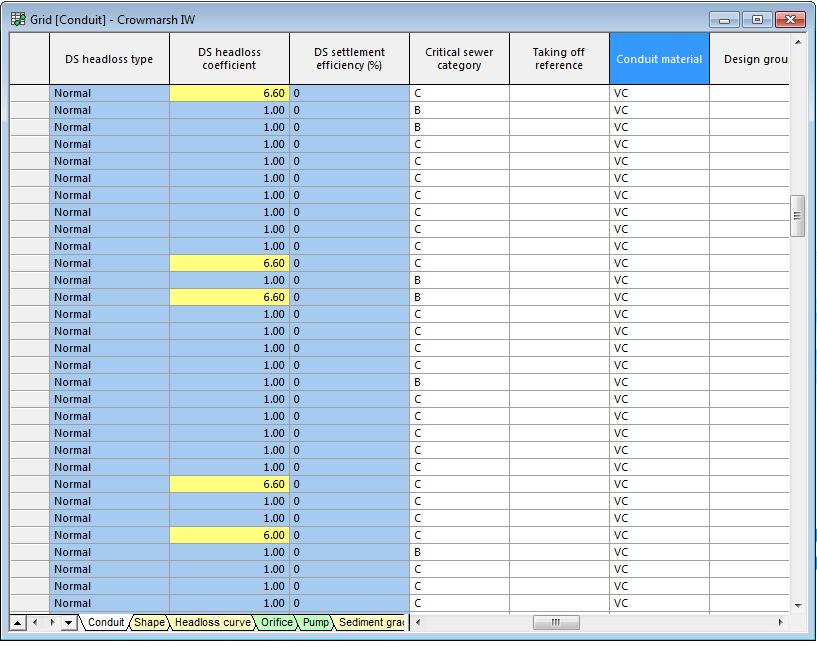
27 Finding a column in a grid (v7.0)
28 Version 7.5 Improvements to the Job Progress Window for 2D runs Extensions to Simplifying Object Geometry Multiple simulations run on the same GPU card Enhanced 3D view Geodatabase tables can be imported using the ODIC

29 Improvements to the Job Progress Window for 2D runs (v7.5)
 Polygon area constraint to ensure that polygons are not")
30 Extensions to Simplifying Object Geometry (v7.5) Polygon area constraint to ensure that polygons are not over-thinned Remove spurs
31 Multiple simulations run on the same GPU card (v7.5) Multiple simulations run simultaneously on the same GPU card Previously restricted to one simulation per card The Job Agent automatically assigns each GPU-using simulation to a card (subject to a limit set by the user), and will use the card with the fewest simulations assigned to it first

32
33 Latest Release

34 QUESTIONS? Thanks for listening
What's New in this Version
 What's New in this Version This topic lists all the additions and improvements incorporated in InfoWorks ICM v4.5 which were not available in previous versions. Flood risk analysis New functionality has
Potential Applications of the new InfoWorks ICM Mesh level Zones
 Introduction Potential Applications of the new InfoWorks ICM Mesh level Zones Exciting new functionality has been added to InfoWorks ICM version 5.5 to allow improved editing of the 2D mesh. The new functionality
Automatic Discretization and Parameterization of Watersheds using a Digital Elevation Model
 Automatic Discretization and Parameterization of Watersheds using a Digital Elevation Model Ellen Hachborn, Karen Finney, Rob James, Nandana Perera, Tiehong Xiao WaterTech 2017 Computational Hydraulics
Tips for a Good Meshing Experience
 Tips for a Good Meshing Experience Meshes are very powerful and flexible for modeling 2D overland flows in a complex urban environment. However, complex geometries can be frustrating for many modelers
Connecting 1D and 2D Domains
 Connecting 1D and 2D Domains XP Solutions has a long history of Providing original, high-performing software solutions Leading the industry in customer service and support Educating our customers to be
12d Model Training Notes Training Modules for 12d Model
 12d Model Training Notes Training Modules for 12d Model June 2018 12d Model V11.0 Training Modules for 12d Model Manual June 2018 Disclaimer 12d Model is supplied without any express or implied warranties
2D Model Implementation for Complex Floodplain Studies. Sam Crampton, P.E., CFM Dewberry
 2D Model Implementation for Complex Floodplain Studies Sam Crampton, P.E., CFM Dewberry 2D Case Studies Case Study 1 Rain-on-Grid 2D floodplain simulation for unconfined flat topography in coastal plain
Hydraulics and Floodplain Modeling Modeling with the Hydraulic Toolbox
 v. 9.1 WMS 9.1 Tutorial Hydraulics and Floodplain Modeling Modeling with the Hydraulic Toolbox Learn how to design inlet grates, detention basins, channels, and riprap using the FHWA Hydraulic Toolbox
This loads a preset standard set of data appropriate for Malaysian modeling projects.
 XP Software On-Site Detention (OSD) Example Step 1 Open xpswmm2010 program Or from Start menu select Programs XPS - then select xpswmm2010 Select Create From Template Save file, e.g. Filename.xp The program
Prof. B.S. Thandaveswara. The computation of a flood wave resulting from a dam break basically involves two
 41.4 Routing The computation of a flood wave resulting from a dam break basically involves two problems, which may be considered jointly or seperately: 1. Determination of the outflow hydrograph from the
Certificant PDH Log. Please use this form to track your PDHs. Certificant Contact Information. Name: Organization: Address: City, State, Zip:
 Certificant PDH Log Certificants are required to complete 14 hours of professional development (PDH) every two years to meet certification requirements. These are typically completed via participation
Numerical Hydraulics
 ETHZ, Fall 2017 Numerical Hydraulics Assignment 3 Comparison of two numerical solutions of river flow: use of Finite Elements (HEC-RAS) and Finite Volumes (BASEMENT) 1 Introduction In the course, two different
Objectives This tutorial demonstrates how to perform unsteady sediment transport simulations in SRH-2D.
 SMS v. 12.2 SRH-2D Tutorial Objectives This tutorial demonstrates how to perform unsteady sediment transport simulations in SRH-2D. Prerequisites SMS Overview tutorial SRH-2D SRH-2D Sediment Transport
Integrated 2D Surface-Groundwater Modeling of the Green Swamp, Florida
 Integrated 2D Surface-Groundwater Modeling of the Green Swamp, Florida Peter J. Singhofen, P.E. Gordon L. McClung, P.E Streamline Technologies, Inc. 1900 Town Plaza Ct. Winter Springs, FL 32708 407-679-1696
XP Solutions has a long history of Providing original, high-performing software solutions Leading the industry in customer service and support
 Housekeeping Ask Questions! Type queries into the Question Field in the GoToWebinar interface. The webinar will be recorded and posted on innovyze.com If you have REGISTERED, you will receive an email
Build a MODRAT model by defining a hydrologic schematic
 v. 11.0 WMS 11.0 Tutorial Build a MODRAT model by defining a hydrologic schematic Objectives Learn how to define a basic MODRAT model using the hydrologic schematic tree in WMS by building a tree and defining
XP Solutions has a long history of Providing original, high-performing software solutions Leading the industry in customer service and support
 XP Solutions has a long history of Providing original, high-performing software solutions Leading the industry in customer service and support Educating our customers to be more successful in their work.
v TUFLOW-2D Hydrodynamics SMS Tutorials Time minutes Prerequisites Overview Tutorial
 v. 12.2 SMS 12.2 Tutorial TUFLOW-2D Hydrodynamics Objectives This tutorial describes the generation of a TUFLOW project using the SMS interface. This project utilizes only the two dimensional flow calculation
Integrated Groundwater Surface Water Modeling of the Green Swamp, Florida
 Integrated Groundwater Surface Water Modeling of the Green Swamp, Florida Data Management Challenges and Opportunities Peter J. Singhofen, P.E. Gordon L. McClung, P.E Streamline Technologies, Inc. 1900
Watershed Analysis and A Look Ahead
 Watershed Analysis and A Look Ahead 1 2 Specific Storm Flow to Grate What data do you need? Watershed boundaries for each storm sewer Net flow generated from each point across the landscape Elevation Fill
Title: Improving Your InRoads DTM. Mats Dahlberg Consultant Civil
 Title: Improving Your InRoads DTM Mats Dahlberg Consultant Civil Improving Your InRoads Digital Terrain Model (DTM) Digital Terrain Model A digital representation of a surface topography or terrain composed
L7 Raster Algorithms
 L7 Raster Algorithms NGEN6(TEK23) Algorithms in Geographical Information Systems by: Abdulghani Hasan, updated Nov 216 by Per-Ola Olsson Background Store and analyze the geographic information: Raster
Modeling Detention Ponds Malaysian Example (v2009)
") Modeling Detention Ponds Malaysian Example (v2009) This tutorial demonstrates the usability of xpswmm and xpstorm for simulating detention basins in urban areas. This fictitious example includes the use
Modeling Detention Ponds Malaysian Example (v2009) This tutorial demonstrates the usability of xpswmm and xpstorm for simulating detention basins in urban areas. This fictitious example includes the use
2D Modeling for Approximate Areas. Monica S. Urisko, P.E. CFM
 2D Modeling for Approximate Areas Monica S. Urisko, P.E. CFM Ferrin P. Affleck, P.E. CFM Outline Types of Modeling Available Steady vs Unsteady 1D vs 2D Software available Basics of 2D modeling Inputs
v TUFLOW 1D/2D SMS 11.2 Tutorial Time minutes Prerequisites TUFLOW 2D Tutorial
 v. 11.2 SMS 11.2 Tutorial Objectives This tutorial describes the generation of a 1D TUFLOW project using the SMS interface. It is strongly recommended that the TUFLOW 2D tutorial be completed before doing
Package swmmr. April 10, 2018
 Type Package Title R Interface for US EPA's SWMM Package swmmr April 10, 2018 Functions to connect the widely used Storm Water Management Model (SWMM) of the United States Environmental Protection Agency
Ducks on the Pond: Stormwater Management Basin Analysis Using AutoCAD Civil 3D and Autodesk SSA
 Ducks on the Pond: Stormwater Management Basin Analysis Using AutoCAD Civil 3D and Autodesk Josh Kehs, P.E. Autodesk, Inc. CI4541 Learning Objectives At the end of this class, you will be able to: Model
Channel Routing & Lakes/Reservoirs in WRF-Hydro
 Channel Routing & Lakes/Reservoirs in WRF-Hydro L. Read, D. Yates National Center for Atmospheric Research Channel Routing Channel Routing Methods Set in hydro.namelist with the channel_option = 1, 2 or
GTS. midas GTS Advanced Webinar. Date: June 5, 2012 Topic: General Use of midas GTS (Part II) Presenter: Vipul Kumar
 Presenter: Vipul Kumar") midas GTS Advanced Webinar Date: June 5, 2012 Topic: General Use of midas GTS (Part II) Presenter: Vipul Kumar Bridging Your Innovations to Realities GTS MIDAS Information Technology Co., Ltd. [1/30] Contents:
midas GTS Advanced Webinar Date: June 5, 2012 Topic: General Use of midas GTS (Part II) Presenter: Vipul Kumar Bridging Your Innovations to Realities GTS MIDAS Information Technology Co., Ltd. [1/30] Contents:
WMS 10.0 Tutorial Watershed Modeling MODRAT Interface Schematic Build a MODRAT model by defining a hydrologic schematic
 v. 10.0 WMS 10.0 Tutorial Watershed Modeling MODRAT Interface Schematic Build a MODRAT model by defining a hydrologic schematic Objectives This tutorial shows users how to define a basic MODRAT model using
George Mason University Department of Civil, Environmental and Infrastructure Engineering. Dr. Celso Ferreira
 George Mason University Department of Civil, Environmental and Infrastructure Engineering Dr. Celso Ferreira Exercise Topic: HEC GeoRAS Post-Processing Objectives: This tutorial is designed to walk you
WMS 10.0 Tutorial Storm Drain Modeling SWMM Modeling Learn how to link a hydrologic model to the SWMM storm drain model
 v. 10.0 WMS 10.0 Tutorial Learn how to link a hydrologic model to the SWMM storm drain model Objectives Build a rational method hydrologic model and compute sub-basin flows. Import storm drain network
Storm Water Management Model User's Manual Version 5.1
 United States Environmental Protection Agency EPA/600/R-14/413b Revised September 2015 - www2.epa.gov/water-research - Storm Water Management Model User's Manual Version 5.1 Office of Research and Development
WMS 9.1 Tutorial Storm Drain Modeling SWMM Modeling Learn how to link a hydrologic model to the SWMM storm drain model
 v. 9.1 WMS 9.1 Tutorial Learn how to link a hydrologic model to the SWMM storm drain model Objectives Build a rational method hydrologic model and compute sub-basin flows. Import storm drain network information
Learn how to link a hydrologic model to the SWMM storm drain model
 v. 10.1 WMS 10.1 Tutorial Learn how to link a hydrologic model to the SWMM storm drain model Objectives Build a rational method hydrologic model and compute sub-basin flows. Import storm drain network
Linear Routing: Floodrouting. HEC-RAS Introduction. Brays Bayou. Uniform Open Channel Flow. v = 1 n R2/3. S S.I. units
 Linear Routing: Floodrouting HEC-RAS Introduction Shirley Clark Penn State Harrisburg Robert Pitt University of Alabama April 26, 2004 Two (2) types of floodrouting of a hydrograph Linear Muskingum Reservoir
lecture 8 Groundwater Modelling -1
 The Islamic University of Gaza Faculty of Engineering Civil Engineering Department Water Resources Msc. Groundwater Hydrology- ENGC 6301 lecture 8 Groundwater Modelling -1 Instructor: Dr. Yunes Mogheir
Layout of Presentation
 Specialized Training Course On Modelling For River Engineering Applications On : SSIIM Program (25th -29th September, 2011), Egypt By : Dr: Ahmed Musa Siyam Eng: Elnazir Saad Ali Layout of Presentation
WMS 10.1 Tutorial GSSHA Modeling Basics Post-Processing and Visualization of GSSHA Model Results Learn how to visualize GSSHA model results
 v. 10.1 WMS 10.1 Tutorial GSSHA Modeling Basics Post-Processing and Visualization of GSSHA Model Results Learn how to visualize GSSHA model results Objectives This tutorial demonstrates different ways
WMS 9.1 Tutorial GSSHA Modeling Basics Post-Processing and Visualization of GSSHA Model Results Learn how to visualize GSSHA model results
 v. 9.1 WMS 9.1 Tutorial GSSHA Modeling Basics Post-Processing and Visualization of GSSHA Model Results Learn how to visualize GSSHA model results Objectives This tutorial demonstrates different ways of
Feature Analyst Quick Start Guide
 Feature Analyst Quick Start Guide River Extraction River extractions are much like road extractions, in that you are trying to identify a continuous object running through other features within your image.
HEC-RAS 3.0 January, 2001 Release Notes
 HEC-RAS 3.0 January, 2001 Release Notes A new version of HEC-RAS (3.0) has been released with significant new features over the previous version (2.21). Version 3.0 includes unsteady flow routing capabilities,
Watershed Modeling Maricopa Predictive HEC-1 Model. Watershed Modeling Maricopa County: Master Plan Creating a Predictive HEC-1 Model
 v. 10.1 WMS 10.1 Tutorial Watershed Modeling Maricopa County: Master Plan Creating a Predictive HEC-1 Model Build a watershed model to predict hydrologic reactions based on land use development in Maricopa
Questions and Answers
 Autodesk Storm and Sanitary Analysis Extension 2011 Questions and Answers Design stormwater and wastewater systems more effectively with integrated analysis. Contents 1. GENERAL PRODUCT INFORMATION...
Geometry Regents Lomac Date 3/17 due 3/18 3D: Area and Dissection 9.1R. A point has no measure because a point represents a
 Geometry Regents Lomac 2015-2016 Date 3/17 due 3/18 3D: Area and Dissection Name Per LO: I can define area, find area, and explain dissection it relates to area and volume. DO NOW On the back of this packet
Bentley OpenRoads Workshop 2017 FLUG Fall Training Event
 Bentley OpenRoads Workshop 2017 FLUG Fall Training Event F-1P - Designing with a Pond Bentley Systems, Incorporated 685 Stockton Drive Exton, PA 19341 www.bentley.com Practice Workbook This workbook is
This tutorial shows how to build a Sedimentation and River Hydraulics Two-Dimensional (SRH-2D) simulation. Requirements
 simulation. Requirements") v. 13.0 SMS 13.0 Tutorial Objectives This tutorial shows how to build a Sedimentation and River Hydraulics Two-Dimensional () simulation. Prerequisites SMS Overview tutorial Requirements Model Map Module
v. 13.0 SMS 13.0 Tutorial Objectives This tutorial shows how to build a Sedimentation and River Hydraulics Two-Dimensional () simulation. Prerequisites SMS Overview tutorial Requirements Model Map Module
Creating raster DEMs and DSMs from large lidar point collections. Summary. Coming up with a plan. Using the Point To Raster geoprocessing tool
 Page 1 of 5 Creating raster DEMs and DSMs from large lidar point collections ArcGIS 10 Summary Raster, or gridded, elevation models are one of the most common GIS data types. They can be used in many ways
Groundwater in Hydrologic Cycle
 Groundwater in Hydrologic Cycle Types of Terrestrial Water Surface Water Soil Moisture Ground water Pores Full of Combination of Air and Water Unsaturated Zone / Zone of Aeration / Vadose (Soil Water)
TUFLOW 1D/2D SURFACE WATER MODELING SYSTEM. 1 Introduction. 2 Background Data
 SURFACE WATER MODELING SYSTEM TUFLOW 1D/2D 1 Introduction This tutorial describes the generation of a 1D TUFLOW project using the SMS interface. It is recommended that the TUFLOW 2D tutorial be done before
Lidar and GIS: Applications and Examples. Dan Hedges Clayton Crawford
 Lidar and GIS: Applications and Examples Dan Hedges Clayton Crawford Outline Data structures, tools, and workflows Assessing lidar point coverage and sample density Creating raster DEMs and DSMs Data area
Genetic Programming For Cellular Automata Urban Inundation Modelling
 City University of New York (CUNY) CUNY Academic Works International Conference on Hydroinformatics 8-1-2014 Genetic Programming For Cellular Automata Urban Inundation Modelling Mike J. Gibson Edward C.
v Prerequisite Tutorials GSSHA Modeling Basics Stream Flow GSSHA WMS Basics Creating Feature Objects and Mapping their Attributes to the 2D Grid
 v. 10.1 WMS 10.1 Tutorial GSSHA Modeling Basics Developing a GSSHA Model Using the Hydrologic Modeling Wizard in WMS Learn how to setup a basic GSSHA model using the hydrologic modeling wizard Objectives
Cross Sections, Profiles, and Rating Curves. Viewing Results From The River System Schematic. Viewing Data Contained in an HEC-DSS File
 C H A P T E R 9 Viewing Results After the model has finished the steady or unsteady flow computations the user can begin to view the output. Output is available in a graphical and tabular format. The current
NGICP Approved Trainer. Marketing Packet
 NGICP Approved Trainer Marketing Packet The Water Environment Federation invites trainers to become an approved trainer in the National Green Infrastructure Certification Program (NGICP). Approved trainers
WMS 9.1 Tutorial GSSHA Modeling Basics Stream Flow Integrate stream flow with your GSSHA overland flow model
 v. 9.1 WMS 9.1 Tutorial Integrate stream flow with your GSSHA overland flow model Objectives Learn how to add hydraulic channel routing to your GSSHA model and how to define channel properties. Learn how
WMS 8.4 Tutorial Watershed Modeling MODRAT Interface (GISbased) Delineate a watershed and build a MODRAT model
 Delineate a watershed and build a MODRAT model") v. 8.4 WMS 8.4 Tutorial Watershed Modeling MODRAT Interface (GISbased) Delineate a watershed and build a MODRAT model Objectives Delineate a watershed from a DEM and derive many of the MODRAT input parameters
v. 8.4 WMS 8.4 Tutorial Watershed Modeling MODRAT Interface (GISbased) Delineate a watershed and build a MODRAT model Objectives Delineate a watershed from a DEM and derive many of the MODRAT input parameters
WinSLAMM v 10.2 User s Guide
 WinSLAMM v 10.2 User s Guide Batch Editor, Cost Analysis, pre Development Runoff Volume Calculation lationandand Creating a Model File from a Data File Batch Editor Running a Set of Files Batch Editor
AutoCAD Civil 3D 2010 Education Curriculum Instructor Guide Unit 4: Environmental Design
 AutoCAD Civil 3D 2010 Education Curriculum Instructor Guide Unit 4: Environmental Design Lesson 2 Watershed Analysis Overview In this lesson, you learn about how AutoCAD Civil 3D software is used to analyze
George Mason University Department of Civil, Environmental and Infrastructure Engineering. Dr. Celso Ferreira Prepared by Lora Baumgartner
 George Mason University Department of Civil, Environmental and Infrastructure Engineering Dr. Celso Ferreira Prepared by Lora Baumgartner Exercise Topic: Getting started with HEC GeoRAS Objective: Create
Introducing ArcScan for ArcGIS
 Introducing ArcScan for ArcGIS An ESRI White Paper August 2003 ESRI 380 New York St., Redlands, CA 92373-8100, USA TEL 909-793-2853 FAX 909-793-5953 E-MAIL info@esri.com WEB www.esri.com Copyright 2003
HEC-RAS 2D Flood Modelling Tutorial
 HEC-RAS 2D Flood Modelling Tutorial Civil Site Design and HECRAS 2D Flood Modelling HECRAS version 5 and later includes functionality to analyse water flows moving across a surface. this is known as 2D
What s new in Civil Designer 2015
 What s new in Civil Designer 2015 We have concentrated on adding in additional functionality requested by our extensive client base as well as optimising existing features. Survey & Terrain Significant
Objectives This tutorial shows how to build a Sedimentation and River Hydraulics Two-Dimensional (SRH-2D) simulation.
 simulation.") v. 12.1 SMS 12.1 Tutorial Objectives This tutorial shows how to build a Sedimentation and River Hydraulics Two-Dimensional () simulation. Prerequisites SMS Overview tutorial Requirements Model Map Module
v. 12.1 SMS 12.1 Tutorial Objectives This tutorial shows how to build a Sedimentation and River Hydraulics Two-Dimensional () simulation. Prerequisites SMS Overview tutorial Requirements Model Map Module
iric Software Changing River Science River2D Tutorials
 iric Software Changing River Science River2D Tutorials iric Software Changing River Science Confluence of the Colorado River, Blue River and Indian Creek, Colorado, USA 1 TUTORIAL 1: RIVER2D STEADY SOLUTION
SRH-2D Additional Boundary Conditions
 v. 12.2 SMS 12.2 Tutorial SRH-2D Additional Boundary Conditions Objectives Learn techniques for using various additional boundary conditions with the Sedimentation and River Hydraulics Two-Dimensional
H y d r o C A D. Owner's Manual
 H y d r o C A D Stormwater Modeling System Version 8 Owner's Manual Copyright 2006 HydroCAD Software Solutions LLC. All rights reserved. HydroCAD is a registered trademark of HydroCAD Software Solutions
URBAN & RURAL RUNOFF ROUTING APPLICATION GETTING STARTED MANUAL
 URBAN & RURAL RUNOFF ROUTING APPLICATION GETTING STARTED MANUAL Copyright 2013 XP Solutions. All right reserved. No part of this publication maybe reproduced in any form by any means without the written
IP SWITCHES. 1. Receive INFLOWS DATA IN
 IP SWITCHES 1. Receive INFLOWS IP SWITCHES 1. Receive INFLOWS 2. BUFFER & Route IP SWITCHES 1. Receive INFLOWS 2. BUFFER & Route 3. Transmit OUTFLOWS IP SWITCHES 1. Receive INFLOWS 2. BUFFER & Route 3.
Spatial Hydrologic Modeling Using NEXRAD Rainfall Data in an HEC-HMS (MODClark) Model
 Model") v. 10.0 WMS 10.0 Tutorial Spatial Hydrologic Modeling Using NEXRAD Rainfall Data in an HEC-HMS (MODClark) Model Learn how to setup a MODClark model using distributed rainfall data Objectives Read an existing
v. 10.0 WMS 10.0 Tutorial Spatial Hydrologic Modeling Using NEXRAD Rainfall Data in an HEC-HMS (MODClark) Model Learn how to setup a MODClark model using distributed rainfall data Objectives Read an existing
ICMLive & SWMMLive Getting Started v8.0
 Contents ICMLive & SWMMLive Getting Started v8.0... 1 Document Overview... 3 System overview... 4 ICMLive / SWMMLive Configuration Manager... 4 ICMLive / SWMMLive Operator Client... 4 Innovyze Live Server...
Day 1. HEC-RAS 1-D Training. Rob Keller and Mark Forest. Break (9:45 am to 10:00 am) Lunch (12:00 pm to 1:00 pm)
 Lunch (12:00 pm to 1:00 pm)") Day 1 HEC-RAS 1-D Training Rob Keller and Mark Forest Introductions and Course Objectives (8:00 am to 8:15 am) Introductions: Class and Content Module 1 Open Channel Hydraulics (8:15 am to 9:45 am) Lecture
Day 1 HEC-RAS 1-D Training Rob Keller and Mark Forest Introductions and Course Objectives (8:00 am to 8:15 am) Introductions: Class and Content Module 1 Open Channel Hydraulics (8:15 am to 9:45 am) Lecture
NEW xpswmm & xpstorm 2017
 NEW xpswmm & xpstorm 2017 Housekeeping Ask Questions! Type queries into the Questions Field in the GoToWebinar interface. The webinar will be recorded and posted on xpsolutions.com If you have REGISTERED,
HEC-22 Inlets in INFOSWMM and H2OMAP SWMM v12
 HEC-22 Inlets in INFOSWMM and H2OMAP SWMM v12 Table of Contents How the Inlet and Overland Junctions are Defined 3 Why Would You Use the HEC-22 Inlets Option? 4 Types of Inlets 5 Nodes in InfoSWMM and
DO NOW Geometry Regents Lomac Date. due. 3D: Area, Dissection, and Cavalieri
 DO NOW Geometry Regents Lomac 2014-2015 Date. due. 3D: Area, Dissection, and Cavalieri (DN) ON BACK OF PACKET Name Per LO: I can define area, find area, and explain dissection and Cavalieri s Principle
Algorithms for GIS csci3225
 Algorithms for GIS csci3225 Laura Toma Bowdoin College Flow on digital terrain models (I) Flow Where does the water go when it rains? Flooding: What are the areas susceptible to flooding? Sea level rise:
Modeling Storm Sewer Networks in the City of Newport News, Virginia Using Two Different Software Solutions
 Modeling Storm Sewer Networks in the City of Newport News, Virginia Using Two Different Software Solutions Mid-Atlantic Chapter APWA Annual Conference May 9 th, 2013 Overview + Storm Water Modeling Basics
Lecture 6: GIS Spatial Analysis. GE 118: INTRODUCTION TO GIS Engr. Meriam M. Santillan Caraga State University
 Lecture 6: GIS Spatial Analysis GE 118: INTRODUCTION TO GIS Engr. Meriam M. Santillan Caraga State University 1 Spatial Data It can be most simply defined as information that describes the distribution
Concept: Solids Volume and Surface Area
 Concept: Solids Volume and Surface Area COMPUTER COMPONENT Name: Instructions: In follow the Content Menu path: Measurement and Geometry > Solids Volume and Surface Area Work through all Sub Lessons of
INCREASING CLASSIFICATION QUALITY BY USING FUZZY LOGIC
 JOURNAL OF APPLIED ENGINEERING SCIENCES VOL. 1(14), issue 4_2011 ISSN 2247-3769 ISSN-L 2247-3769 (Print) / e-issn:2284-7197 INCREASING CLASSIFICATION QUALITY BY USING FUZZY LOGIC DROJ Gabriela, University
PCSWMM 2002 RUNOFF Block PAT AVENUE Storm Drainage Design
 PCSWMM 2002 RUNOFF Block PAT AVENUE Storm Drainage Design A Hello World Example Prepared by Robert Pitt and Alex Maestre, Department of Civil Engineering, University of Alabama April 10, 2002 Introduction
GEO-SLOPE International Ltd, Calgary, Alberta, Canada Lysimeters
 1 Introduction Lysimeters This steady state SEEP/W example illustrates how to model a lysimeter from construction of the model to interpretation of the results. Lysimeters are used to measure flow through
MapInfo Pro. Version 17 Overview
 MapInfo Pro tm Version 17 Overview 1 Disclaimers & Notes Most of what you ll see is a Work in Progress There will be some bugs and incomplete functionality Some things being shown are not yet available
MIKE SHE Basic Exercises
 MIKE SHE - Basic Exercises 1 MIKE SHE Basic Exercises 1 INTRODUCTION... 3 1.1 HYDROLOGIC PROCESSES SIMULATED BY MIKE SHE... 3 1.2 APPLICATIONS AROUND THE WORLD... 3 1.3 THE MIKE SHE USER INTERFACE... 4
Watershed Modeling HEC-HMS Interface
 v. 10.1 WMS 10.1 Tutorial Learn how to set up a basic HEC-HMS model using WMS Objectives Build a basic HEC-HMS model from scratch using a DEM, land use, and soil data. Compute the geometric and hydrologic
Application of RiskMaster to the Crayford ICM Model
 Application of RiskMaster to the Crayford ICM Model Innovyze Conference June 2014 Francesca Hurt 1 CRAYFORD MODEL OVERVIEW 2 Crayford Model InfoWorks ICM 1D-2D Model Variable Mesh Integrate Sewer, River
GPU - Next Generation Modeling for Catchment Floodplain Management. ASFPM Conference, Grand Rapids (June 2016) Chris Huxley
 Chris Huxley") GPU - Next Generation Modeling for Catchment Floodplain Management ASFPM Conference, Grand Rapids (June 2016) Chris Huxley Presentation Overview 1. What is GPU flood modeling? 2. What is possible using
GPU - Next Generation Modeling for Catchment Floodplain Management ASFPM Conference, Grand Rapids (June 2016) Chris Huxley Presentation Overview 1. What is GPU flood modeling? 2. What is possible using
SMS v Simulations. SRH-2D Tutorial. Time. Requirements. Prerequisites. Objectives
 SMS v. 12.1 SRH-2D Tutorial Objectives This tutorial will demonstrate the process of creating a new SRH-2D simulation from an existing simulation. This workflow is very useful when adding new features
Spatial Hydrologic Modeling HEC-HMS Distributed Parameter Modeling with the MODClark Transform
 v. 9.0 WMS 9.0 Tutorial Spatial Hydrologic Modeling HEC-HMS Distributed Parameter Modeling with the MODClark Transform Setup a basic distributed MODClark model using the WMS interface Objectives In this
FLOODPLAIN MODELING MANUAL. HEC-RAS Procedures for HEC-2 Modelers
 FLOODPLAIN MODELING MANUAL HEC-RAS Procedures for HEC-2 Modelers Federal Emergency Management Agency Mitigation Directorate 500 C Street, SW Washington, DC 20472 April 2002 Floodplain Modeling Manual HEC-RAS
Lecture 7 Digitizing. Dr. Zhang Spring, 2017
 Lecture 7 Digitizing Dr. Zhang Spring, 2017 Model of the course Using and making maps Navigating GIS maps Map design Working with spatial data Geoprocessing Spatial data infrastructure Digitizing File
NUMERICAL MODELING STUDY FOR FLOW PATTERN CHANGES INDUCED BY SINGLE GROYNE
 NUMERICAL MODELING STUDY FOR FLOW PATTERN CHANGES INDUCED BY SINGLE GROYNE Jungseok Ho 1, Hong Koo Yeo 2, Julie Coonrod 3, and Won-Sik Ahn 4 1 Research Assistant Professor, Dept. of Civil Engineering,
Appendix C.6. Best Management Practices for Construction Activities
 Appendix C.6 Best Management Practices for Construction Activities In accordance with Section F.2 of San Diego Regional Water Quality Control Board (RWQCB) Order 2001-01 (Permit), the City of La Mesa has
Transient Groundwater Analysis
 Transient Groundwater Analysis 18-1 Transient Groundwater Analysis A transient groundwater analysis may be important when there is a time-dependent change in pore pressure. This will occur when groundwater
v SMS Tutorials SRH-2D Prerequisites Requirements SRH-2D Model Map Module Mesh Module Data files Time
 v. 11.2 SMS 11.2 Tutorial Objectives This tutorial shows how to build a Sedimentation and River Hydraulics Two-Dimensional () simulation using SMS version 11.2 or later. Prerequisites SMS Overview tutorial
Flood Routing for Continuous Simulation Models
 Improving Life through Science and Technology Flood Routing for Continuous Simulation Models J. Williams, W. Merkel, J. Arnold, J. Jeong 11 International SWAT Conference, Toledo, Spain, June 15-17, 11
George Mason University Department of Civil, Environmental and Infrastructure Engineering. Dr. Celso Ferreira Prepared by Lora Baumgartner
 George Mason University Department of Civil, Environmental and Infrastructure Engineering Dr. Celso Ferreira Prepared by Lora Baumgartner Exercise Topic: Getting started with HEC RAS Objective: Create
Storm Drain Modeling HY-12 Pump Station
 v. 10.1 WMS 10.1 Tutorial Storm Drain Modeling HY-12 Pump Station Analysis Setup a simple HY-12 pump station storm drain model in the WMS interface with pump and pipe information Objectives Using the HY-12
Surface Area And Volume Worksheets With Answers
 We have made it easy for you to find a PDF Ebooks without any digging. And by having access to our ebooks online or by storing it on your computer, you have convenient answers with surface area and volume
UNIT 0 - MEASUREMENT AND GEOMETRY CONCEPTS AND RELATIONSHIPS
 UNIT 0 - MEASUREMENT AND GEOMETRY CONCEPTS AND RELATIONSHIPS UNIT 0 - MEASUREMENT AND GEOMETRY CONCEPTS AND RELATIONSHIPS... 1 INTRODUCTION MATH IS LIKE A DATING SERVICE... 3 A FRAMEWORK FOR UNDERSTANDING