ArcGIS Pro. Terminology Guide
|
|
|
- Meredith Neal
- 5 years ago
- Views:
Transcription


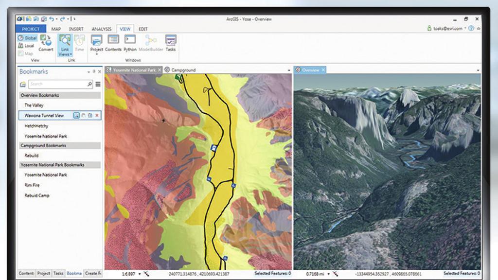
1 ArcGIS Pro Terminology Guide
2 Essential Terminology or Functionality That s New to ArcGIS Pro ArcGIS Pro Project Map Scene Ribbon Tab on the ribbon View Active view Pane Gallery Task Quick Access Toolbar Portal ScreenTips KeyTips Usage A collection of related geographic datasets, maps, layouts, tools, settings, and resources, saved in an.aprx file The project item used to display and work with geographic data in two dimensions (A map opens in a map view.) The project item used to display and work with geographic data in three dimensions The rectangular area across the top of the application composed of tabs that contain software functionality A region on the ribbon that groups related software commands The window representing the primary work area of the application The view that currently has keyboard focus (The active view controls the contents of the ribbon.) A dockable window that contains a related set of commands A rectangular window or menu that presents an array or grid of visual choices A set of preconfigured steps to guide users through a workflow or business process A collection of icons located on the title bar that provides shortcuts to commonly used commands Connection to an ArcGIS Online or Portal for ArcGIS organization Pop-up info tips that appear when you hover over the ribbon Small tips that appear when you press the Alt key and show keyboard shortcuts for the ribbon Similar Concepts in Other ArcGIS for Desktop Applications Data frame Global scene: ArcGlobe document (.3dd) Local scene: ArcScene document (.sxd) User interface menus and toolbars Toolbar Similar to a map view or layout view, but there can be other types in Active data frame Dockable window Similar to functionality in the Task Assistant Manager extension Similar to ArcGIS Administrator > Add Portal Connection. In, connect to a portal on the Project tab > Portals tab Hover over a button on a toolbar Press Alt and an underlined letter
3 General Items Terminology and User Interface Cross-Reference Contents pane Project pane Map view Layout view Select item in Contents pane to open additional ribbon tabs and tools Explore tool Click with the Explore tool Attributes pane Default project database Locate pane Add Folder Edit tab on the ribbon Geoprocessing pane (opened from the Analysis tab) Geoprocessing History Fields, Subtypes, and Domains views Project tab > Options Data tab > Export Features (opens Copy Features tool) Active Portal ArcMap and Other ArcGIS for Desktop Products Table of Contents window Similar to the Catalog window Data view Layout view; layout of an ArcMap document (.mxd) Right-click item in Contents window to access the context menu (This is still available in.) Contains functionality of Pan, Zoom, and other navigation tools, and HTML Pop-Up and Identify tools Get a pop-up window about what you clicked; similar to HTML Pop-Up and Identify tools Similar to the Attributes and Identify Results windows, also allows editing Default map (or scene or globe) document geodatabase Find tool Create Folder Connection Editor toolbar Search tools, show the system toolbox, and run geoprocessing tools; similar to ArcToolbox window and tool dialog boxes Results window Feature Class Properties and Geodatabase Properties dialog boxes Contains settings for customizing Right-click a layer in the table of contents > Data > Export Data Default connection to the ArcGIS Online or Portal for ArcGIS organization where you share and search for content
4 Mapping and Visualization Terminology and User Interface Cross-Reference Symbology pane Symbology pane > Gallery Symbology pane > Properties Point symbol Polygon symbol Color scheme Style File Favorites style Project styles Preset layer Raster functions Appearance tab for rasters Activate map frame on a layout Element pane Save As Layout File Layout file (.pagx) ArcPy.mp ArcMap and Other ArcGIS for Desktop Applications Symbology tab on the Layer Properties dialog box Symbol Selector Symbol Property Editor Marker symbol Fill symbol Color ramp Style File Personal style Referenced styles A prebuilt layer embedded in that only requires a data source Similar to Image Analysis window > Processing section, but exposes all functions and more functionality Similar to Image Analysis window > Display section Similar to focus data frame on a layout Element property dialog boxes Similar to File > Save As Similar to templates Significant update to the ArcPy.mapping module for Python scripting
5 Sharing Terminology and User Interface Cross-Reference Share content Project package (.ppkx) Map package (.mpkx) Layer package (.lpkx) Share or publish a web layer Share Web Layer pane Messages tab Web layer Web feature layer Web tile layer Project template (.aptx) Save As Map File Map file (.mapx) Save As Layer File Layer file (.lyrx) Export Map ArcMap and Other ArcGIS for Desktop Applications Umbrella term referring to packaging, publishing, and sharing new items File type used to package an entire project (new in ) File type used to package a map; similar to an.mpk file File type used to package an individual layer; similar to an.lpk file Publish a service Publishing wizard and Service Editor Similar to the Prepare window Service Feature service Tile service/cached map service File type used to build a template for a new project (new in ) Similar to File > Save As Similar to an.mxd file Similar to Save As Layer File Similar to an.lyr file Similar to File > Export Map
6 Editing Editing is enabled at all times Active Select tool on the Modify Features pane Create Features pane Modify Features pane Manage Templates pane Reposition toolbar Construction toolbar Vertices toolbar Similar Concepts in Other ArcGIS for Desktop Applications Start editing Edit tool Create Features window Contains tools for editing features, similar to those on editing toolbars Organize Feature Templates window Contains Move, Scale, and Rotate tools, similar to those on editing toolbars Contains segment construction tools, similar to those on editing toolbars Edit Vertices toolbar Additional ArcGIS Resources ArcGIS Online: arcgis.com What s New in ArcGIS: esri.com/whatsnew ArcGIS Resource Center: resources.arcgis.com Support: esri.com/support Training: esri.com/training Books: esri.com/esripress Copyright 2015 Esri. All rights reserved. Esri, the Esri globe logo, ArcGIS, ArcMap, ArcGlobe, ArcScene, ArcToolbox, arcgis.com, and esri.com are trademarks, service marks, or registered marks of Esri in the United States, the European Community, or certain other jurisdictions. Other companies and products or services mentioned herein may be trademarks, service marks, or registered marks of their respective mark owners ESRI 1/15tk-ca
ArcGIS Pro Terminology Guide
 ArcGIS Pro Terminology Guide Essential Terminology or Functionality That s New to ArcGIS Pro ArcGIS Pro Project Map Scene Ribbon Tab on the ribbon View Active view Pane Gallery Task Quick Access Toolbar
ArcGIS Pro Terminology Guide
 ArcGIS Pro Terminology Guide Sharing Terminology and User Interface Cross-Reference Share content Project package (.ppkx) Map package (.mpkx) Layer package (.lpkx) Share or publish a web layer Share Web
ArcGIS. for Desktop. Tips and Shortcuts 10.1
 ArcGIS 10.1 for Desktop Tips and Shortcuts Map Navigation Refresh and redraw the display. F5 Suspend the map s drawing. F9 Zoom in and out. Center map. Roll the mouse wheel backward and forward. Hold down
Migrating from ArcMap to ArcGIS Pro. David Watkins Scott Noulis
 Migrating from ArcMap to ArcGIS Pro David Watkins Scott Noulis Getting Started with ArcGIS Pro ArcGIS Pro 64 bit, multi-threaded Simplified user interface Integrated with the ArcGIS platform Combined 2D/3D
ArcGIS Pro: Mapping & Visualization. David Watkins, Edie Punt &
 ArcGIS Pro: Mapping & Visualization David Watkins, Edie Punt & Craig Williams @daviddwatkins, @epunt, & @williamscraigm Mapping an Visualization Vision In ArcGIS Pro Improve drawing performance and quality
ArcGIS. ArcGIS Desktop. Tips and Shortcuts
 ArcGIS ArcGIS Desktop Tips and Shortcuts Map Navigation Function Shortcut Availability Refresh and redraw the display. F5 9.1, Suspend the map s drawing. F9 9.1, Zoom in and out. Center map. Roll the mouse
ArcGIS. ArcGIS Desktop. Tips and Shortcuts
 ArcGIS ArcGIS Desktop Tips and Shortcuts Map Navigation Refresh and redraw the display. F5 9.1, Suspend the map s drawing. F9 9.1, Zoom in and out. Center map. Roll the mouse wheel backward and forward.
ModelBuilder: An Introduction. Kevin Armstrong
 ModelBuilder: An Introduction Kevin Armstrong What is ModelBuilder? A user-friendly way to automate a series of tools Part of the ArcGIS geoprocessing framework - ModelBuilder can run any tool in the ArcToolbox,
Answer the following general questions: 1. What happens when you right click on an icon on your desktop? When you left double click on an icon?
 Name: Date: June 27th, 2011 GIS Boot Camps For Educators Practical: Explore ArcGIS 10 Desktop Tools and functionality Day_1 Lecture 1 Sources: o ArcGIS Desktop help o ESRI website o Getting to Know ArcGIS
The ArcMap Interface and Using Basic ArcMap Analysis Tools to Create a Map
 The ArcMap Interface and Using Basic ArcMap Analysis Tools to Create a Map *You will need a computer with ESRI ArcGIS Desktop version 9.3 or higher installed* Data Download 1. Save the zipped folder with
ArcGIS. Desktop. A Selection of Time-Saving Tips and Shortcuts
 ArcGIS Desktop A Selection of Time-Saving Tips and Shortcuts Map Navigation Refresh and redraw the display F5 9.1, Suspend the map s drawing F9 9.1, Zoom in and out Roll the mouse wheel backward and forward.
Chapter 3 The project
 Chapter 3 The project Background ArcGIS Pro organizes the user experience with data in a completely different way from ArcMap, through a construct known as a project. What is a project? The project is
Exporting ArcScene to 3D Web Scenes. Documents. An Esri White Paper November 2013
 Exporting ArcScene to 3D Web Scenes Documents An Esri White Paper November 2013 Copyright 2013 Esri All rights reserved. Printed in the United States of America. The information contained in this document
Migrating to ArcGIS Pro. John Sharrard, Esri Solutions Engineer
 Migrating to ArcGIS Pro John Sharrard, Esri Solutions Engineer jsharrard@esri.com ArcGIS Desktop Desktop Web Device ArcMap ArcCatalog ArcScene ArcGlobe ArcGIS Pro Portal Server Online Content and Services
Search & Rescue Map Specifications and Production Workflows
 Search & Rescue Map Specifications and Production Workflows About The Search & Rescue map product and production procedures discussed in this document can be utilized to support search, rescue, and relief
ArcGIS Desktop: Introduction to Geoprocessing with ModelBuilder Kevin Armstrong ESRI
 ArcGIS Desktop: Introduction to Geoprocessing with ModelBuilder Kevin Armstrong ESRI SERUG 2008 1 What is ModelBuilder? A user-friendly way to automate a series of tools Part of the ArcGIS geoprocessing
Visualization with ArcGlobe. Brady Hoak
 Visualization with ArcGlobe Brady Hoak Contents What is ArcGlobe? 3D Mapping and ArcGlobe Displaying data in ArcGlobe ArcGlobe tools Tips for constructing ArcGlobe documents New at ArcGIS 9.3 ArcGIS integration
Working with Metadata in ArcGIS
 Esri International User Conference San Diego, California Technical Workshops July 26, 2012 Working with Metadata in ArcGIS Aleta Vienneau Metadata in ArcGIS ArcGIS metadata goals Editing metadata Setting
An ESRI Technical Paper May 2007 Techniques for Consuming 3D Textured Objects in ArcGlobe and ArcScene
 An ESRI Technical Paper May 2007 Techniques for Consuming 3D Textured Objects in ArcGlobe and ArcScene ESRI 380 New York St., Redlands, CA 92373-8100 USA TEL 909-793-2853 FAX 909-793-5953 E-MAIL info@esri.com
Create a personal geodatabase
 Create a personal geodatabase To create a personal geodatabase that corresponds to the same release as the ArcGIS for Desktop client you are using, follow these steps: 1. In ArcCatalog, right-click the
ArcGIS Desktop The Road Ahead. Amadea Azerki
 ArcGIS Desktop The Road Ahead Amadea Azerki Agenda An Overview of ArcGIS 10 Desktop Enhancements User Interface Mapping Editing Analysis Sharing Q & A ArcGIS 10 Overview Focuses on Usability and Productivity
LAB 1: Introduction to ArcGIS 8
 LAB 1: Introduction to ArcGIS 8 Outline Introduction Purpose Lab Basics o About the Computers o About the software o Additional information Data ArcGIS Applications o Starting ArcGIS o o o Conclusion To
Geographical Information Systems Institute. Center for Geographic Analysis, Harvard University. LAB EXERCISE 1: Basic Mapping in ArcMap
 Harvard University Introduction to ArcMap Geographical Information Systems Institute Center for Geographic Analysis, Harvard University LAB EXERCISE 1: Basic Mapping in ArcMap Individual files (lab instructions,
ArcGIS Pro: What s New in Editing and Data Management
 Federal GIS Conference February 9 10, 2015 Washington, DC ArcGIS Pro: What s New in Editing and Data Management Robert LeClair ArcGIS Pro Overview Esri FedUC 2015 Technical Workshop ArcGIS Pro: What's
Exercise 1: Getting to know ArcGIS
 The Scenario You are working for the California Visitor s Commission. You have been asked to prepare a map of California for several dignitaries from out of the country. Your map will need to include enough
Animation in ArcMap Tutorial
 ArcGIS 9 Animation in ArcMap Tutorial Copyright 2005 2006 ESRI All Rights Reserved. Printed in the United States of America. The information contained in this document is the exclusive property of ESRI.
How to Set Workspace Environments for Project Work
 How to Set Workspace Environments for Project Work An ESRI Short Tutorial January 2006 ESRI 380 New York St., Redlands, CA 92373-8100, USA TEL 909-793-2853 FAX 909-793-5953 E-MAIL info@esri.com WEB www.esri.com
Using ArcScan for ArcGIS
 ArcGIS 9 Using ArcScan for ArcGIS Copyright 00 005 ESRI All rights reserved. Printed in the United States of America. The information contained in this document is the exclusive property of ESRI. This
No Programming Required Create web apps rapidly with Web AppBuilder for ArcGIS
 No Programming Required Create web apps rapidly with Web AppBuilder for ArcGIS By Derek Law, Esri Product Manager, ArcGIS for Server Do you want to build web mapping applications you can run on desktop,
Chapter 5. Presenting Data
 Chapter 5. Presenting Data Copyright McGraw-Hill Education. Permission required for reproduction or display. 5-1 Map Design Process 5-2 1 About ArcGIS Chapter 5. Presenting Data 5-3 Page layouts and map
Tutorial 1 Exploring ArcGIS
 Tutorial 1 Exploring ArcGIS Before beginning this tutorial, you should make sure your GIS network folder is mapped on the computer you are using. Please refer to the How to map your GIS server folder as
Enabling High-Quality Printing in Web Applications. Tanu Hoque & Scott Moore
 Enabling High-Quality Printing in Web Applications Tanu Hoque & Scott Moore High Quality Printing on the Web Create a printable document (PDF preferably) Have that document printed to exact scale Leverage
Getting Started With LP360
 Getting Started With LP360 12/22/2015 1 Contents What is LP360?... 3 System Requirements... 3 Installing LP360... 4 How to Enable the LP360 Extension... 4 How to Display the LP360 Toolbar... 4 How to Import
Geospatial Databases: Metadata, Standards, and Infrastructure
 Geospatial Databases: Metadata, Standards, and Infrastructure What is metadata? Information that describes items in ArcGIS is called metadata. When care is taken to provide good descriptions, you can find
Explore some of the new functionality in ArcMap 10
 Explore some of the new functionality in ArcMap 10 Scenario In this exercise, imagine you are a GIS analyst working for Old Dominion University. Construction will begin shortly on renovation of the new
What's New in ArcGIS 9.2 Service Packs
 What's New in ArcGIS 9.2 Service Packs 8 July 2008 Updated for Service Pack 6 This document describes the main enhancements to 9.2 added by the service packs. It does not cover the bug fixes and quality
Introduction to ArcGIS Server 10.1
 Introduction to ArcGIS Server 10.1 E-Learning for the GIS Professional Any Time, Any Place! geospatialtraining.com Module Outline What is ArcGIS Server? GIS Resources and Services ArcGIS Server Components
Mid-West ESRI Utility User s Group Conference. March 26, 2014
 Mid-West ESRI Utility User s Group Conference March 26, 2014 Presented by: Hillary Bjorstrom, GIS Analyst STAR Energy Services LLC 1 What are Data Driven Pages? Data Driven Pages Workflow Creating an Index
Sharing Web Layers and Services in the ArcGIS Platform. Melanie Summers and Ty Fitzpatrick
 Sharing Web Layers and Services in the Platform Melanie Summers and Ty Fitzpatrick Agenda Platform overview - Web GIS information model - Two deployment options Pro Sharing - User experience and workflows
hereby recognizes that Timotej Verbovsek has successfully completed the web course 3D Analysis of Surfaces and Features Using ArcGIS 10
 3D Analysis of Surfaces and Features Using ArcGIS 10 Completed on September 5, 2012 3D Visualization Techniques Using ArcGIS 10 Completed on November 19, 2011 Basics of Map Projections (for ArcGIS 10)
MAPLOGIC CORPORATION. GIS Software Solutions. Getting Started. With MapLogic Layout Manager
 MAPLOGIC CORPORATION GIS Software Solutions Getting Started With MapLogic Layout Manager Getting Started with MapLogic Layout Manager 2011 MapLogic Corporation All Rights Reserved 330 West Canton Ave.,
Serving Imagery with ArcGIS Server 10.1
 Serving Imagery with ArcGIS Server 10.1 Presented by: André Piasta apiasta@esri.ca Esri Canada Users Conference Calgary, AB 28 May 2013 Today s Agenda ArcGIS server and image services Publishing of imagery
Cartographic Techniques and Representations
 Cartographic Techniques and Representations NEARC 2007 ESRI Technical Session ESRI, Boston Overview of Presentation Labeling and Annotation Masking Layout Tips Cartographic Representations Labeling versus
Chapter 7. A Quick Tour of ArcGIS Pro
 Chapter 7 A Quick Tour of ArcGIS Pro Skills you will learn: This tutorial is intended to get you going using ArcGIS Pro, a new desktop application that is part of ArcGIS Desktop. A separate tutorial gives
ArcMap Editing Tips and Tricks. Sean Jones
 ArcMap Editing Tips and Tricks Sean Jones Overview Topics - Tuning your editing map - Creating features - Editing features and attributes - Aligning and editing coincident features - Addins Format - Software
ArcGIS 4: Sharing Content on the Web STUDENT EDITION
 ArcGIS 4: Sharing Content on the Web STUDENT EDITION Copyright 2016 Esri All rights reserved. Course version 3.1.1. Version release date July 2016. Printed in the United States of America. The information
Getting to Know ModelBuilder
 Getting to Know ModelBuilder Offered by Shane Bradt through the UNH Cooperative Extension Geospatial Technologies Training Center Developed by Sandy Prisloe and Cary Chadwick at the Geospatial Technology
Encoded URLs in hyperlinks. TerraGo Publisher for ArcGIS TerraGo Publisher for ArcGIS Server TerraGo Arc2Edge Version 7.3.
 TerraGo Publisher for ArcGIS TerraGo Publisher for ArcGIS Server TerraGo Arc2Edge Version 7.3.1, December 2017 What is TerraGo Publisher for ArcGIS? What is TerraGo Arc2Edge? What s new in this release?
Stacey Maples GIS Specialist and Instruction Coordinator, Yale University Map Department
 WHAT S NEW IN ARC CGIS 10-5 THINGS YOU SHOUL LD KNOW! (OK, THERE S ACTUALLY MORE THAN 5 HERE) Stacey Maples GIS Specialist and Instruction Coordinator, Yale University Map Department stacey.maples@yale.edu
PISCES Installation and Getting Started 1
 This document will walk you through the PISCES setup process and get you started accessing the suite of available tools. It will begin with what options to choose during the actual installation and the
Building 3D models with the horizons method
 ARC HYDRO GROUNDWATER TUTORIALS SUBSURFACE ANALYST Building 3D models with the horizons method Arc Hydro Groundwater (AHGW) is a geodatabase design for representing groundwater datasets within ArcGIS.
Display Layers in Geosoft 3D View
 Use the New 2D/3D Workflow features in Target for ArcGIS In Target for ArcGIS version 3.5, there are three new interconnected features that make integrating 2D and 3D data in plan and section maps easier.
Tutorial 1: Finding and Displaying Spatial Data Using ArcGIS
 Tutorial 1: Finding and Displaying Spatial Data Using ArcGIS This tutorial will introduce you to the following: Websites where you may browse to find geospatial information Identifying spatial data, usable
ArcMap: Tips and Tricks
 Esri International User Conference San Diego, California Technical Workshops July 23 27, 2012 ArcMap: Tips and Tricks Miriam Schmidts Jorge Ruiz-Valdepena Agenda Navigating ArcMap Repairing data links
Data Interoperability Extension Tutorial
 Data Interoperability Extension Tutorial Copyright 1995-2012 Esri All rights reserved. Table of Contents About the Data Interoperability extension tutorial...................... 3 Exercise 1: Using direct-read
ArcGIS Desktop: Fundamentals of Cartography
 ArcGIS Desktop: Fundamentals of Cartography Outline Symbology Style Files -.style Layer files -.lyr Labeling Label Classes Label Expressions Map Document files -.mxd Map Template files -.mxt Map Elements
Exercise 1: An Overview of ArcMap and ArcCatalog
 Exercise 1: An Overview of ArcMap and ArcCatalog Introduction: ArcGIS is an integrated collection of GIS software products for building a complete GIS. ArcGIS enables users to deploy GIS functionality
STUDENT PAGES GIS Tutorial Treasure in the Treasure State
 STUDENT PAGES GIS Tutorial Treasure in the Treasure State Copyright 2015 Bear Trust International GIS Tutorial 1 Exercise 1: Make a Hand Drawn Map of the School Yard and Playground Your teacher will provide
Making a Sackville Coastal Flood Map
 Making a Sackville Coastal Flood Map Demo covers: Accessing and previewing map templates Modifying map elements such as titles, data frames, legends & scale bars Drawing a graphic on a map Adding text
Data for this exercise are located in the L1 subdirectory or the class web page. Videos for this exercise are located in the class web page.
 Lesson 1: What You ll Learn: -Start ArcMap -Create a new map -Add data layers -Pan and zoom -Change data symbology -Change display properties -Set relative paths -Add layers to features -Select data -Measure
Linear Referencing in ArcGIS. GIS by ESRI
 Linear Referencing in ArcGIS GIS by ESRI Copyright 00 ESRI All rights reserved. Printed in the United States of America. The information contained in this document is the exclusive property of ESRI. This
Productivity Tips and Tricks in ArcGIS
 Productivity Tips and Tricks in ArcGIS Outline ArcMap Basics Searching Editing Sharing ArcMap Basics ArcMap Increase usability and work faster Many improvements to make you productive - Shy and stackable
ArcGIS Desktop: Making Maps in ArcMap
 ArcGIS Desktop: Making Maps in ArcMap California, Nevada, Hawaii Regional User Group February 6-8, 6 2008 Sacramento, CA Harry J. Moore IV Outline Symbology Style Files -.style Layer files -.lyr Labeling
What s s Coming in ArcGIS 10 Desktop
 What s s Coming in ArcGIS 10 Desktop Damian Spangrud ArcGIS Product Manager, ESRI dspangrud@esri.com (or at least turn to silent) ArcGIS 10 A Simple & Pervasive System for Using Maps & Geographic Information
Managing Multiple Layouts in ArcGIS Pro
 Managing Multiple Layouts in ArcGIS Pro By Mike Price, Entrada/San Juan, Inc. What you will need ArcGIS Desktop with ArcMap 10.4 or higher and ArcGIS Pro 1.4 licenses ArcGIS Online for organizations account
Integrating CAD Data with ArcGIS
 Integrating CAD Data with ArcGIS Agenda An Overview of CAD Drawings CAD Data Structure in ArcGIS Visualization Georeferencing Data Conversion ArcGIS for AutoCAD Q & A CAD Drawings - Overview Widely used
Basic Tasks in ArcGIS 10.3.x
 Basic Tasks in ArcGIS 10.3.x This guide provides instructions for performing a few basic tasks in ArcGIS 10.3.1, such as adding data to a map document, viewing and changing coordinate system information,
Dell S2718H/S2718HX/S2718HN/ S2718NX Dell Display Manager User s Guide
 Dell S2718H/S2718HX/S2718HN/ S2718NX Dell Display Manager User s Guide Model : S2718H/S2718HX/S2718HN/S2718NX Regulatory model : S2718Hc/S2718Nc NOTE : A NOTE indicates important information that helps
Server Usage & Third-Party Viewers
 Server Usage & Third-Party Viewers October 2016 HiPER LOOK Version 1.4.16.0 Copyright 2015 PIXIA Corp. All Rights Reserved. Table of Contents HiPER LOOK Server Introduction... 2 Google Earth... 2 Installation...2
Work Smart: Microsoft Office 2010 User Interface
 About the Office 2010 User Interface You can use this guide to learn how to use the new features of the Microsoft Office Ribbon. Topics in this guide include: What s New in the Office 2010 User Interface
ArcGIS Basics Working with Labels and Annotation
 ArcGIS Basics Working with Labels and Annotation Labeling in ArcGIS has changed considerably from the old ArcView 3.X version. In ArcGIS label positions are generated automatically, are not selectable,
ArcGIS Runtime SDKs Building Offline Apps. Nick Furness
 ArcGIS Runtime SDKs Building Offline Apps Nick Furness Agenda The basics - Considerations - Building blocks - Service types New! Offline maps New! Preplanned workflow What we are covering and what not
4. If you are prompted to enable hardware acceleration to improve performance, click
 Exercise 1a: Creating new points ArcGIS 10 Complexity: Beginner Data Requirement: ArcGIS Tutorial Data Setup About creating new points In this exercise, you will use an aerial photograph to create a new
Introduction to GIS 2011
 Introduction to GIS 2011 Digital Elevation Models CREATING A TIN SURFACE FROM CONTOUR LINES 1. Start ArcCatalog from either Desktop or Start Menu. 2. In ArcCatalog, create a new folder dem under your c:\introgis_2011
Using ArcGIS 10.x Introductory Guide University of Toronto Mississauga Library Hazel McCallion Academic Learning Centre
 Using ArcGIS 10.x Introductory Guide University of Toronto Mississauga Library Hazel McCallion Academic Learning Centre FURTHER ASSISTANCE If you have questions or need assistance, please contact: Andrew
Working with Feature Layers. Russell Brennan Gary MacDougall
 Working with Feature Layers Russell Brennan Gary MacDougall Working with Feature Layers Session will focus on feature access and editing Highlight new features added over the last few releases Agenda Introduction
Table of Contents. 1. Prepare Data for Input. CVEN 2012 Intro Geomatics Final Project Help Using ArcGIS
 Table of Contents 1. Prepare Data for Input... 1 2. ArcMap Preliminaries... 2 3. Adding the Point Data... 2 4. Set Map Units... 3 5. Styling Point Data: Symbology... 4 6. Styling Point Data: Labels...
Lesson 1: Getting Started with
 Microsoft Office Specialist 2016 Series Microsoft Outlook 2016 Certification Guide Lesson 1: Getting Started with Email Lesson Objectives In this lesson, you will learn to identify Outlook program items,
What's New in ArcGIS 9.2 Service Packs
 What's New in ArcGIS 9.2 Service Packs 18 July 2007 Updated for Service Pack 3 This document describes the main enhancements to 9.2 added by the service packs. It does not cover the bug fixes and quality
Name: Date: June 27th, 2011 GIS Boot Camps For Educators Lecture_3
 Name: Date: June 27th, 2011 GIS Boot Camps For Educators Lecture_3 Practical: Creating and Editing Shapefiles Using Straight, AutoComplete and Cut Polygon Tools Use ArcCatalog to copy data files from:
GIS IN ECOLOGY: CREATING RESEARCH MAPS
 GIS IN ECOLOGY: CREATING RESEARCH MAPS Contents Introduction... 2 Elements of Cartography... 2 Course Data Sources... 3 Tasks... 3 Establishing the Map Document... 3 Laying Out the Map... 5 Exporting Your
Using ArcGIS. Tracking Analyst. GIS by ESRI
 Using ArcGIS Tracking Analyst GIS by ESRI Copyright (c) 2002 TASC, Inc. and its licensor(s). All Rights Reserved. Printed in the United States of America. The information contained in this document is
ArcScan for ArcGIS Tutorial
 ArcGIS 9 ArcScan for ArcGIS Tutorial Copyright 00 008 ESRI All rights reserved. Printed in the United States of America. The information contained in this document is the exclusive property of ESRI. This
What s New in Desktop 10.1
 What s New in Desktop 10.1 Damian Spangrud Esri Redlands Trip Down Memory Lane ArcGIS A Complete System for Geographic Information Cloud Web Online Mobile Enterprise Desktop Sharing Information sharing
Microsoft Access 2013
 Microsoft Access 2013 Chapter 1 Databases and Database Objects: An Introduction Objectives Describe the features of the Access window Create a database Create tables in Datasheet and Design views Add records
Enabling High-Quality Printing in Web Applications. Tanu Hoque & Jeff Moulds
 Enabling High-Quality Printing in Web Applications Tanu Hoque & Jeff Moulds Print Service Technical Session Outline What s new in 10.6x What is Print Service Out of the box print solutions Print service
Sharing GIS Content Using ArcGIS STUDENT EDITION
 Sharing GIS Content Using ArcGIS STUDENT EDITION Copyright 2018 Esri All rights reserved. Course version 1.1. Version release date April 2018. Printed in the United States of America. The information contained
Task Switcher. Martin Gräßlin
 Martin Gräßlin 2 Contents 1 Navigating through Windows 4 1.1 Visualization......................................... 4 1.2 Shortcuts........................................... 4 1.3 Content............................................
COPYRIGHTED MATERIAL. Introduction to 3D Data: Modeling with ArcGIS 3D Analyst and Google Earth CHAPTER 1
 CHAPTER 1 Introduction to 3D Data: Modeling with ArcGIS 3D Analyst and Google Earth Introduction to 3D Data is a self - study tutorial workbook that teaches you how to create data and maps with ESRI s
Word 2013 Quick Start Guide
 Getting Started File Tab: Click to access actions like Print, Save As, and Word Options. Ribbon: Logically organize actions onto Tabs, Groups, and Buttons to facilitate finding commands. Active Document
Debbie Keller. Microsoft Office 2007 Highlights. Adobe CS3 Suites. Pearson Prentice Hall DDC
 Microsoft Office 2007 Highlights Adobe CS3 Suites Debbie Keller Career & Tech Department Coordinator Warren High School San Antonio Texas Pearson Prentice Hall DDC Extreme Makeover Office 2007 is the most
Arcgis 10 Manually Move Labels
 Arcgis 10 Manually Move Labels The "easy custom labeling" Tool in QGIS seems to come close to the ArcGIS solution. However, after I created my custom label layer I am not able to move my labels at the
SolidWorks Implementation Guides. User Interface
 SolidWorks Implementation Guides User Interface Since most 2D CAD and SolidWorks are applications in the Microsoft Windows environment, tool buttons, toolbars, and the general appearance of the windows
ARC HYDRO TOOLS CONFIGURATION DOCUMENT #3 GLOBAL DELINEATION WITH EDNA DATA
 ARC HYDRO TOOLS CONFIGURATION DOCUMENT #3 GLOBAL DELINEATION WITH EDNA DATA Environmental Systems Research Institute, Inc. (Esri) 380 New York Street Redlands, California 92373-8100 Phone: (909) 793-2853
GIS LAB 8. Raster Data Applications Watershed Delineation
 GIS LAB 8 Raster Data Applications Watershed Delineation This lab will require you to further your familiarity with raster data structures and the Spatial Analyst. The data for this lab are drawn from
GEOGRAPHIC INFORMATION SYSTEMS Lecture 25: 3D Analyst
 GEOGRAPHIC INFORMATION SYSTEMS Lecture 25: 3D Analyst 3D Analyst - 3D Analyst is an ArcGIS extension designed to work with TIN data (triangulated irregular network) - many of the tools in 3D Analyst also
CVEN 2012 GEOMATICS LAB SPRING 2016 INTRO TO ESRI ARCGIS
 CVEN 2012 GEOMATICS LAB SPRING 2016 INTRO TO ESRI ARCGIS Objectives 1. Download and Add Data into ArcMap 2. Symbolize and Label Features 3. Navigate and Investigate the Map 4. Explore Attributes and Metadata
ArcGIS 9. Using ArcCatalog
 ArcGIS 9 Using ArcCatalog Copyright 1999, 2003 2004 ESRI All rights reserved. Printed in the United States of America. The information contained in this document is the exclusive property of ESRI. This
ArcGIS 9. Using ArcCatalog
 ArcGIS 9 Using ArcCatalog Copyright 1999, 2003 2005 ESRI All rights reserved. Printed in the United States of America. The information contained in this document is the exclusive property of ESRI. This
Getting Started with ArcGIS for Server. Charmel Menzel and Ken Gorton
 Getting Started with ArcGIS for Server Charmel Menzel and Ken Gorton Agenda What is ArcGIS for Server? Types of Web services Publishing resources onto the Web Clients to ArcGIS for Server Editions and