Analytical and Computer Cartography Winter Lecture 9: Geometric Map Transformations
|
|
|
- Philippa Wilson
- 5 years ago
- Views:
Transcription

1 Analytical and Computer Cartography Winter 2017 Lecture 9: Geometric Map Transformations
2 Cartographic Transformations Attribute Data (e.g. classification) Locational properties (e.g. projection) Graphics (e.g. symbolization) Information content of maps (e.g. data structure conversion)
3 Dimensional Transformations


4 Geometric map transformations Same dimension: e.g. point to point in a projection Change structure: e.g. TIN to grid in a DEM Change scale: e.g. Area to point as a city is generalized
")
5 Planar geometries Cartesian Spherical (ellipsoidal) Radial
6 Analysis Input: geometric feature Point, line, Area, Surface, Volumes Output: Reduce feature to single dimension: e.g. centroid, length, perimeter, area in square unit lengths Output: A scalar, numerical value reflecting quantity Collapse E.g. shape, sinuosity, network metric Can compute using algorithms

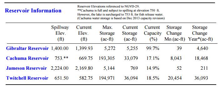

7 Lake Cachuma

 e.g. wetlands")
8 Uncertainty in Geometric features Assume infinite thinness Assume exact location Assume unambiguous ontology (definition) e.g. wetlands
9
 Actually at: 34.156136,73.")
10 Likely location and setting (3 given) Actually at: ,

11 Abbottabad
12 Assuming crisp features: Points, lines, areas, volumes What simple transformations can be performed on PLAV in Euclidean space? In C language typedef struct POINT { int point_id, double x, double y}; POINT Point[100]; int npts; Create a loop double sumx = 0.0 for (i=0; I <= npts; i++) sumx += Point[i].x; meanx = sumx / npts;
13 Planar Map Transformations on Points - Length of a line Repetitive application of point-to-point distance calculation For n points, algorithm/formula uses n-1 segments (x 1, y 1 ) (x n, y n )
14 Length of a Line Estimate?
15 Length of a generic line i x i y i x i -x i-1 y i -y i-1 (x i -x i-1 ) 2 (y i -y i-1 ) 2 (x i -x i-1 ) 2 + (y i -y i-1 ) 2 (x i -x i-1 ) 2 + (y i -y i-1 ) 2 Sqrt[(x i -x i-1 ) 2 + (y i -y i-1 ) 2] Sum = 8.3 units
16 Planar Map Transformations on Points - Centroids Multiple point or line or area to be transformed to single point Point can be "real" or representative Can use weightings or populations Mean center simple to compute but may fall outside point cluster or polygon Can use point-in-polygon to test for inclusion

17

18 Mean point vs. centroid
19 Planar Map Transformations on Points - Standard Distance Just as centroid is an indication of representative location, standard distance is mean dispersion Equivalent of standard deviation for an attribute, mean variation from mean Around centroid, makes a "radius" tracing a circle
20 Standard distance

21
22 Planar Map Transformations on Points - Nearest Neighbor Statistic NNS is a single dimensionless scalar that measures the pattern of a set of point (point-> scalar) Computes nearest point-to-point separation as a ratio of expected given the area Highly sensitive to the area chosen Available in ArcGIS etc

23 Local NNS: Cluster busting
24 Planar Map Transformations Based on Lines - Intersection of two lines Absolutely fundamental to many mapping operations, such as overlay and clipping. In raster mode it can be solved by layer overlay. In vector mode it must be solved geometrically. Lines (2) to point transformation

25 Raster solution: add binary arrays Red = 1 Blue = 2 Green = 3
26 Planar Map Transformations Based on Lines - Intersection of two lines (cnt.) When using this algorithm, a problem exists when b2 - b1 = 0 (divide by zero) Special case solutions or tests must be used These can increase computation time greatly Computation time can be reduced by pre-testing, e.g. based on bounding box.
27 Bounding Box if (x < minx) or (x > maxx) or (y < miny) or (y > maxy) then point is outside maxy minx maxx miny
28 Planar Map Transformations Based on Lines - Distance from a Point to a Line


29 Used to create a buffer
30 Planar Map Transformations Based on Areas Computing the area of a vector polygon (closed) Manually, many methods are used, e.g. cell counts, points on grid. For a raster, simply count the interior pixels Vector Mode more complex

31 Planar Map Transformations Based on Areas
32 Polygon direction Clockwise: Sum is positive Counter-clockwise: Negative So make holes counter clockwise, include in area calculation, then add

33 Planar Map Transformations Based on Areas - Point-in-Polygon Again, a basic and fundamental test, used in many algorithms. For raster mode, use overlay. For vector mode, many solutions. Most commonly used is the Jordan Arc Theorem Tests every segment for line intersection Test point selected to be outside polygon
34 Another Point-in-Polygon Algorithm Calculate area of polygon Find test point Calculate area for all triangles made by center and two sequential exterior points If sum of areas is the area of the polygon, point is inside polygon

35 Planar Map Transformations Based on Areas - Theissen Polygons Often called proximal regions or Voronoi diagrams Often used for contouring terrain, climate, interpolation, etc cneel/pointsetreconstruction.html
36 Affine Transformations These are transformation of the fundamental geometric attributes, i.e. location. Influence absolute location, not relative or topological Necessary for many operations, e.g. digitizing, scanning, geo-registration, and display Affine Transformations take place in three steps (TRS) in order Translation Rotation Scaling

37 Affine Transformations - Translation Movement of the origin between coordinate systems
38 Affine Transformations - Rotation Rotation of axes by an angle theta

39 Affine Transformations - Scaling The numbers along the axes are scaled to represent the new space scale

40 Affine Transformations Possible to use matrix algebra to combine the whole transformation into one matrix multiplication. Step must then be applied to every point
41 Statistical Space Transformations - Rubber Sheeting Select points in two geometries that match Suitable points are targets, e.g. road intersections, runways etc Use least squares transformation to fit image to map Involves tolerance and error distribution [x y] = T [u v] then applied to all pixels May require resampling to higher or lower density
 Deliberate distortion of geometry to new \"space\" Type of non-invertible map")
42 Statistical Space Transformations - Cartograms also known as value-by-area maps and varivalent projections (Tobler, 1986) Deliberate distortion of geometry to new "space" Type of non-invertible map projection
43 Symbolization Transformations Screen coordinates are often reduced to a "standard" device Normalization Transformation Standard Device display dimensions are (0,0) to (1,1) World Coordinates-> Normalized Device Coordinates > Device Coordinates
44 Drawing Objects: Primitives Most use model of primitives and attributes The Graphical Kernel System (GKS) has six primitives, each has multiple attributes.
45 GEOJSON Objects : Point, LineString, Polygon, MultiPoint, MultiLineString, and MultiPolygon { } "type": "Feature", "geometry": { }, "type": "Point", "coordinates": [125.6, 10.1] "properties": { } "name": "Dinagat Islands"
46 GoogleEarth KML Objects
47 For example, a LinearRing in KML <?xml version="1.0" encoding="utf-8"?> <kml xmlns=" <Placemark> <name>linearring.kml</name> <Polygon> <outerboundaryis> <LinearRing> <coordinates> , , , , , , , , , ,0 </coordinates> </LinearRing> </outerboundaryis> </Polygon> </Placemark> </kml>

48 Launch GE, bring in KML file
49 Summary Geometry can be crisp or vague, raster or vector Operations can work even when information is vague Algorithms can apply basic transformations for essential measurements, such as clustering, length, area, density Basic features can be ingested into simple programming language data structures Functions then can measure length, mean center, dispersal, area Can also transform geometry in non-invertible ways, e.g. cartograms Last transformation is into normalized device coordinates, then device/viewport coordinates Gave examples of simple objects and their rendering objects
Lecture 6: GIS Spatial Analysis. GE 118: INTRODUCTION TO GIS Engr. Meriam M. Santillan Caraga State University
 Lecture 6: GIS Spatial Analysis GE 118: INTRODUCTION TO GIS Engr. Meriam M. Santillan Caraga State University 1 Spatial Data It can be most simply defined as information that describes the distribution
M. Andrea Rodríguez-Tastets. I Semester 2008
 M. -Tastets Universidad de Concepción,Chile andrea@udec.cl I Semester 2008 Outline refers to data with a location on the Earth s surface. Examples Census data Administrative boundaries of a country, state
Representing Geography
 Data models and axioms Chapters 3 and 7 Representing Geography Road map Representing the real world Conceptual models: objects vs fields Implementation models: vector vs raster Vector topological model
Spatial Analysis (Vector) II
 II") Spatial Analysis (Vector) II GEOG 300, Lecture 9 Dr. Anthony Jjumba 1 A Spatial Network is a set of geographic locations interconnected in a system by a number of routes is a system of linear features
Spatial Analysis (Vector) II GEOG 300, Lecture 9 Dr. Anthony Jjumba 1 A Spatial Network is a set of geographic locations interconnected in a system by a number of routes is a system of linear features
Package geoops. March 19, 2018
 Type Package Package geoops March 19, 2018 Title 'GeoJSON' Topology Calculations and Operations Tools for doing calculations and manipulations on 'GeoJSON', a 'geospatial' data interchange format ().
Applications. Oversampled 3D scan data. ~150k triangles ~80k triangles
 Mesh Simplification Applications Oversampled 3D scan data ~150k triangles ~80k triangles 2 Applications Overtessellation: E.g. iso-surface extraction 3 Applications Multi-resolution hierarchies for efficient
DATA MODELS IN GIS. Prachi Misra Sahoo I.A.S.R.I., New Delhi
 DATA MODELS IN GIS Prachi Misra Sahoo I.A.S.R.I., New Delhi -110012 1. Introduction GIS depicts the real world through models involving geometry, attributes, relations, and data quality. Here the realization
layers in a raster model
 layers in a raster model Layer 1 Layer 2 layers in an vector-based model (1) Layer 2 Layer 1 layers in an vector-based model (2) raster versus vector data model Raster model Vector model Simple data structure
Data Representation in Visualisation
 Data Representation in Visualisation Visualisation Lecture 4 Taku Komura Institute for Perception, Action & Behaviour School of Informatics Taku Komura Data Representation 1 Data Representation We have
Geometry Practice. 1. Angles located next to one another sharing a common side are called angles.
 Geometry Practice Name 1. Angles located next to one another sharing a common side are called angles. 2. Planes that meet to form right angles are called planes. 3. Lines that cross are called lines. 4.
Spatial Analysis and Modeling (GIST 4302/5302) Guofeng Cao Department of Geosciences Texas Tech University
 Guofeng Cao Department of Geosciences Texas Tech University") Spatial Analysis and Modeling (GIST 4302/5302) Guofeng Cao Department of Geosciences Texas Tech University Outline of Today Last week, we learned: Characteristics of spatial data Types of spatial data
Spatial Analysis and Modeling (GIST 4302/5302) Guofeng Cao Department of Geosciences Texas Tech University Outline of Today Last week, we learned: Characteristics of spatial data Types of spatial data
Practical Linear Algebra: A Geometry Toolbox
 Practical Linear Algebra: A Geometry Toolbox Third edition Chapter 18: Putting Lines Together: Polylines and Polygons Gerald Farin & Dianne Hansford CRC Press, Taylor & Francis Group, An A K Peters Book
Alaska Mathematics Standards Vocabulary Word List Grade 7
 1 estimate proportion proportional relationship rate ratio rational coefficient rational number scale Ratios and Proportional Relationships To find a number close to an exact amount; an estimate tells
Solve 3-D problems using Pythagoras theorem and trigonometric ratios (A*) Solve more complex 2-D problems using Pythagoras theorem & trigonometry (A)
 Solve more complex 2-D problems using Pythagoras theorem & trigonometry (A)") Moving from A to A* Solve 3-D problems using Pythagoras theorem and trigonometric ratios (A*) A* Use the sine & cosine rules to solve more complex problems involving non right-angled triangles (A*) Find
Moving from A to A* Solve 3-D problems using Pythagoras theorem and trigonometric ratios (A*) A* Use the sine & cosine rules to solve more complex problems involving non right-angled triangles (A*) Find
COSC579: Scene Geometry. Jeremy Bolton, PhD Assistant Teaching Professor
 COSC579: Scene Geometry Jeremy Bolton, PhD Assistant Teaching Professor Overview Linear Algebra Review Homogeneous vs non-homogeneous representations Projections and Transformations Scene Geometry The
Graphic Display of Vector Object
 What is GIS? GIS stands for Geographic Information Systems, although the term Geographic Information Science is gaining popularity. A GIS is a software platform for storing, organizing, viewing, querying,
MATHEMATICS Grade 7 Advanced Standard: Number, Number Sense and Operations
 Standard: Number, Number Sense and Operations Number and Number Systems A. Use scientific notation to express large numbers and numbers less than one. 1. Use scientific notation to express large numbers
Mathematics Scope & Sequence Geometry
 Mathematics Scope & Sequence 2016-17 Geometry Revised: June 21, 2016 First Grading Period (24 ) Readiness Standard(s) G.5A investigate patterns to make conjectures about geometric relationships, including
Geometric Modeling. Mesh Decimation. Mesh Decimation. Applications. Copyright 2010 Gotsman, Pauly Page 1. Oversampled 3D scan data
 Applications Oversampled 3D scan data ~150k triangles ~80k triangles 2 Copyright 2010 Gotsman, Pauly Page 1 Applications Overtessellation: E.g. iso-surface extraction 3 Applications Multi-resolution hierarchies
Analytical and Computer Cartography Winter Lecture 11: Generalization and Structure-to-Structure Transformations
 Analytical and Computer Cartography Winter 2017 Lecture 11: Generalization and Structure-to-Structure Transformations Generalization Transformations Conversion of data collected at higher resolutions to
Lecture 10: Image Descriptors and Representation
 I2200: Digital Image processing Lecture 10: Image Descriptors and Representation Prof. YingLi Tian Nov. 15, 2017 Department of Electrical Engineering The City College of New York The City University of
Watershed Sciences 4930 & 6920 GEOGRAPHIC INFORMATION SYSTEMS
 HOUSEKEEPING Watershed Sciences 4930 & 6920 GEOGRAPHIC INFORMATION SYSTEMS CONTOURS! Self-Paced Lab Due Friday! WEEK SIX Lecture RASTER ANALYSES Joe Wheaton YOUR EXCERCISE Integer Elevations Rounded up
Glossary of dictionary terms in the AP geometry units
 Glossary of dictionary terms in the AP geometry units affine linear equation: an equation in which both sides are sums of terms that are either a number times y or a number times x or just a number [SlL2-D5]
Spatial Analysis and Modeling (GIST 4302/5302) Database Fundaments. Database. Review: Bits and Bytes
 Database Fundaments. Database. Review: Bits and Bytes") Spatial Analysis and Modeling (GIST 4302/5302) Database Fundaments Guofeng Cao Department of Geosciences Texas Tech University Review: Bits and Bytes Data stored in a computer system is measured in bits
Spatial Analysis and Modeling (GIST 4302/5302) Database Fundaments Guofeng Cao Department of Geosciences Texas Tech University Review: Bits and Bytes Data stored in a computer system is measured in bits
Lecture overview. Visualisatie BMT. Fundamental algorithms. Visualization pipeline. Structural classification - 1. Structural classification - 2
 Visualisatie BMT Fundamental algorithms Arjan Kok a.j.f.kok@tue.nl Lecture overview Classification of algorithms Scalar algorithms Vector algorithms Tensor algorithms Modeling algorithms 1 2 Visualization
Mathematics Scope & Sequence Grade 8 Revised: June 2015
 Mathematics Scope & Sequence 2015-16 Grade 8 Revised: June 2015 Readiness Standard(s) First Six Weeks (29 ) 8.2D Order a set of real numbers arising from mathematical and real-world contexts Convert between
Edexcel Linear GCSE Higher Checklist
 Number Add, subtract, multiply and divide whole numbers integers and decimals Multiply and divide fractions Order integers and decimals Order rational numbers Use the concepts and vocabulary of factor
APS Sixth Grade Math District Benchmark Assessment NM Math Standards Alignment
 SIXTH GRADE NM STANDARDS Strand: NUMBER AND OPERATIONS Standard: Students will understand numerical concepts and mathematical operations. 5-8 Benchmark N.: Understand numbers, ways of representing numbers,
Geometric Representations. Stelian Coros
 Geometric Representations Stelian Coros Geometric Representations Languages for describing shape Boundary representations Polygonal meshes Subdivision surfaces Implicit surfaces Volumetric models Parametric
CSC Computer Graphics
 // CSC. Computer Graphics Lecture Kasun@dscs.sjp.ac.lk Department of Computer Science University of Sri Jayewardanepura Polygon Filling Scan-Line Polygon Fill Algorithm Span Flood-Fill Algorithm Inside-outside
EE795: Computer Vision and Intelligent Systems
 EE795: Computer Vision and Intelligent Systems Spring 2012 TTh 17:30-18:45 FDH 204 Lecture 10 130221 http://www.ee.unlv.edu/~b1morris/ecg795/ 2 Outline Review Canny Edge Detector Hough Transform Feature-Based
Geometric Correction of Imagery
 Geometric Correction of Imagery Geometric Correction of Imagery Present by: Dr.Weerakaset Suanpaga D.Eng(RS&GIS) The intent is to compensate for the distortions introduced by a variety of factors, so that
RASTER ANALYSIS S H A W N L. P E N M A N E A R T H D A T A A N A LY S I S C E N T E R U N I V E R S I T Y O F N E W M E X I C O
 RASTER ANALYSIS S H A W N L. P E N M A N E A R T H D A T A A N A LY S I S C E N T E R U N I V E R S I T Y O F N E W M E X I C O TOPICS COVERED Spatial Analyst basics Raster / Vector conversion Raster data
An Introduction to Spatial Databases
 An Introduction to Spatial Databases R. H. Guting VLDB Journal v3, n4, October 1994 Speaker: Giovanni Conforti Outline: a rather old (but quite complete) survey on Spatial DBMS Introduction & definition
Georeferencing & Spatial Adjustment
 Georeferencing & Spatial Adjustment Aligning Raster and Vector Data to the Real World Rotation Differential Scaling Distortion Skew Translation 1 The Problem How are geographically unregistered data, either
Copyright The McGraw-Hill Companies, Inc. Permission required for reproduction or display.
 CHAPTER 11 VECTOR DATA ANALYSIS 11.1 Buffering 11.1.1 Variations in Buffering Box 11.1 Riparian Buffer Width 11.1.2 Applications of Buffering 11.2 Overlay 11.2.1 Feature Type and Overlay 11.2.2 Overlay
Calculating bounds in area and volume questions Manipulating complex indices, including surds Solving simultaneous equations - one linear and one
 Calculating bounds in area and volume questions Manipulating complex indices, including surds Solving simultaneous equations - one linear and one quadratic Using equation of a circle and finding points
PITSCO Math Individualized Prescriptive Lessons (IPLs)
") Orientation Integers 10-10 Orientation I 20-10 Speaking Math Define common math vocabulary. Explore the four basic operations and their solutions. Form equations and expressions. 20-20 Place Value Define
Orientation Integers 10-10 Orientation I 20-10 Speaking Math Define common math vocabulary. Explore the four basic operations and their solutions. Form equations and expressions. 20-20 Place Value Define
Middle School Math Course 3
 Middle School Math Course 3 Correlation of the ALEKS course Middle School Math Course 3 to the Texas Essential Knowledge and Skills (TEKS) for Mathematics Grade 8 (2012) (1) Mathematical process standards.
Object modeling and geodatabases. GEOG 419: Advanced GIS
 Object modeling and geodatabases GEOG 419: Advanced GIS CAD Data Model 1960s and 1970s Geographic data stored as points, lines, and areas No attributes; each feature type stored on a different layer No
Multidimensional Data and Modelling - DBMS
 Multidimensional Data and Modelling - DBMS 1 DBMS-centric approach Summary: l Spatial data is considered as another type of data beside conventional data in a DBMS. l Enabling advantages of DBMS (data
Raster Data. James Frew ESM 263 Winter
 Raster Data 1 Vector Data Review discrete objects geometry = points by themselves connected lines closed polygons attributes linked to feature ID explicit location every point has coordinates 2 Fields
Review of Cartographic Data Types and Data Models
 Review of Cartographic Data Types and Data Models GIS Data Models Raster Versus Vector in GIS Analysis Fundamental element used to represent spatial features: Raster: pixel or grid cell. Vector: x,y coordinate
Scientific Visualization Example exam questions with commented answers
 Scientific Visualization Example exam questions with commented answers The theoretical part of this course is evaluated by means of a multiple- choice exam. The questions cover the material mentioned during
Scalar Visualization
 Scalar Visualization Visualizing scalar data Popular scalar visualization techniques Color mapping Contouring Height plots outline Recap of Chap 4: Visualization Pipeline 1. Data Importing 2. Data Filtering
Class #2. Data Models: maps as models of reality, geographical and attribute measurement & vector and raster (and other) data structures
 data structures") Class #2 Data Models: maps as models of reality, geographical and attribute measurement & vector and raster (and other) data structures Role of a Data Model Levels of Data Model Abstraction GIS as Digital
Class #2 Data Models: maps as models of reality, geographical and attribute measurement & vector and raster (and other) data structures Role of a Data Model Levels of Data Model Abstraction GIS as Digital
Introduction to Geometry
 Introduction to Geometry This course covers the topics outlined below. You can customize the scope and sequence of this course to meet your curricular needs. Curriculum (211 topics + 6 additional topics)
Geometry: Concept Categories Concept Category 1 (CC1): Transformations & Basic Definitions
: Transformations & Basic Definitions") Concept Category 1 (CC1): Transformations & Basic Definitions Concept Category 2 (CC2): Triangles (Similarity and Properties) Concept Category 3 (CC3): Triangle Trigonometry Concept Category 4 (CC4): Triangle
Concept Category 1 (CC1): Transformations & Basic Definitions Concept Category 2 (CC2): Triangles (Similarity and Properties) Concept Category 3 (CC3): Triangle Trigonometry Concept Category 4 (CC4): Triangle
2D Transforms. Lecture 4 CISC440/640 Spring Department of Computer and Information Science
 2D Transforms Lecture 4 CISC440/640 Spring 2015 Department of Computer and Information Science Where are we going? A preview of assignment #1 part 2: The Ken Burns Effect 2 Where are we going? A preview
Supporting planning for shape, space and measures in Key Stage 4: objectives and key indicators
 1 of 7 Supporting planning for shape, space and measures in Key Stage 4: objectives and key indicators This document provides objectives to support planning for shape, space and measures in Key Stage 4.
Maps as Numbers. Maps as Numbers. Chapter 3: Maps as Numbers 14SND Getting Started with GIS Chapter 3
 Maps as Numbers Getting Started with GIS Chapter 3 Chapter 3: Maps as Numbers 3.1 Representing Maps as Numbers 3.2 Structuring Attributes 3.3 Structuring Maps 3.4 Why Topology Matters 3.5 Formats for GIS
Geometry Vocabulary Math Fundamentals Reference Sheet Page 1
 Math Fundamentals Reference Sheet Page 1 Acute Angle An angle whose measure is between 0 and 90 Acute Triangle A that has all acute Adjacent Alternate Interior Angle Two coplanar with a common vertex and
PRE-ALGEBRA PREP. Textbook: The University of Chicago School Mathematics Project. Transition Mathematics, Second Edition, Prentice-Hall, Inc., 2002.
 PRE-ALGEBRA PREP Textbook: The University of Chicago School Mathematics Project. Transition Mathematics, Second Edition, Prentice-Hall, Inc., 2002. Course Description: The students entering prep year have
CoE4TN4 Image Processing
 CoE4TN4 Image Processing Chapter 11 Image Representation & Description Image Representation & Description After an image is segmented into regions, the regions are represented and described in a form suitable
YEAR AT A GLANCE Student Learning Outcomes by Marking Period
 2014-2015 Term 1 Overarching/general themes: Tools to Build and Analyze Points, Lines and Angles Dates Textual References To Demonstrate Proficiency by the End of the Term Students Will : Marking Period
Georeferencing & Spatial Adjustment 2/13/2018
 Georeferencing & Spatial Adjustment The Problem Aligning Raster and Vector Data to the Real World How are geographically unregistered data, either raster or vector, made to align with data that exist in
Mathematics High School Geometry An understanding of the attributes and relationships of geometric objects can be applied in diverse contexts
 Mathematics High School Geometry An understanding of the attributes and relationships of geometric objects can be applied in diverse contexts interpreting a schematic drawing, estimating the amount of
Rational Numbers: Graphing: The Coordinate Plane
 Rational Numbers: Graphing: The Coordinate Plane A special kind of plane used in mathematics is the coordinate plane, sometimes called the Cartesian plane after its inventor, René Descartes. It is one
Matija Gubec International School Zagreb MYP 0. Mathematics
 Matija Gubec International School Zagreb MYP 0 Mathematics 1 MYP0: Mathematics Unit 1: Natural numbers Through the activities students will do their own research on history of Natural numbers. Students
Solving inequalities Expanding brackets and simplifying the result Graphing quadratic functions in simple cases Interpreting real-life graphs, e.g.
 Grade C Descriptors Estimation and division by a number less than 1 Calculating compound interest - no rounding necessary Using a calculator in complex situations Multiplication and division by a number
The Problem. Georeferencing & Spatial Adjustment. Nature Of The Problem: For Example: Georeferencing & Spatial Adjustment 9/20/2016
 Georeferencing & Spatial Adjustment Aligning Raster and Vector Data to the Real World The Problem How are geographically unregistered data, either raster or vector, made to align with data that exist in
Introduction Rasterization Z-buffering Shading. Graphics 2012/2013, 4th quarter. Lecture 09: graphics pipeline (rasterization and shading)
") Lecture 9 Graphics pipeline (rasterization and shading) Graphics pipeline - part 1 (recap) Perspective projection by matrix multiplication: x pixel y pixel z canonical 1 x = M vpm per M cam y z 1 This
Lecture 9 Graphics pipeline (rasterization and shading) Graphics pipeline - part 1 (recap) Perspective projection by matrix multiplication: x pixel y pixel z canonical 1 x = M vpm per M cam y z 1 This
Chapter 12 Solid Modeling. Disadvantages of wireframe representations
 Chapter 12 Solid Modeling Wireframe, surface, solid modeling Solid modeling gives a complete and unambiguous definition of an object, describing not only the shape of the boundaries but also the object
Archbold Area Schools Math Curriculum Map
 Math 8 August - May Mathematical Processes Formulate a problem or mathematical model in response to a specific need or situation, determine information required to solve the problem, choose method for
2D rendering takes a photo of the 2D scene with a virtual camera that selects an axis aligned rectangle from the scene. The photograph is placed into
 2D rendering takes a photo of the 2D scene with a virtual camera that selects an axis aligned rectangle from the scene. The photograph is placed into the viewport of the current application window. A pixel
Suggested Foundation Topics for Paper 2
 Suggested Foundation Topics for Paper 2 Number N a N b N b N c N d Add, subtract, multiply and divide any positive and negative integers Order decimals and integers Order rational numbers Use the concepts
Mathematics GCSE 9 1 Higher Syllabus. Yes. Does the subject set according to ability? Skills Covered. Unit
 Mathematics GCSE 9 1 Higher Syllabus Does the subject set according to ability? Unit Unit 1 Unit 2 Unit 3 Unit 4 Yes Skills Covered understand and apply place value correctly. estimate values including
Carnegie Learning Math Series Course 2, A Florida Standards Program
 to the students previous understanding of equivalent ratios Introduction to. Ratios and Rates Ratios, Rates,. and Mixture Problems.3.4.5.6 Rates and Tables to Solve Problems to Solve Problems Unit Rates
Correlation of the ALEKS courses Algebra 1 and High School Geometry to the Wyoming Mathematics Content Standards for Grade 11
 Correlation of the ALEKS courses Algebra 1 and High School Geometry to the Wyoming Mathematics Content Standards for Grade 11 1: Number Operations and Concepts Students use numbers, number sense, and number
7 th Grade Accelerated Learning Targets Final 5/5/14
 7 th Grade Accelerated Learning Targets Final 5/5/14 BSD Grade 7 Long Term Learning Targets & Supporting Learning Targets Quarter 1 & 2 Quarter 3 Quarter 4 7.02, 7.03, 7.04, 7.05 7.06, 8.04, 8.05 7.08,
Clipping. CSC 7443: Scientific Information Visualization
 Clipping Clipping to See Inside Obscuring critical information contained in a volume data Contour displays show only exterior visible surfaces Isosurfaces can hide other isosurfaces Other displays can
Lecture notes: Object modeling
 Lecture notes: Object modeling One of the classic problems in computer vision is to construct a model of an object from an image of the object. An object model has the following general principles: Compact
9. Three Dimensional Object Representations
 9. Three Dimensional Object Representations Methods: Polygon and Quadric surfaces: For simple Euclidean objects Spline surfaces and construction: For curved surfaces Procedural methods: Eg. Fractals, Particle
Unit 6: Connecting Algebra and Geometry Through Coordinates
 Unit 6: Connecting Algebra and Geometry Through Coordinates The focus of this unit is to have students analyze and prove geometric properties by applying algebraic concepts and skills on a coordinate plane.
Direct Rendering. Direct Rendering Goals
 May 2, 2005 Goals General Goals Small memory footprint Fast rendering High-quality results identical to those of Saffron V1 using distance-based anti-aliasing and alignment zones Goals Specific Goals Avoid
Geometric Transformations: Translation:
 Geometric Transformations: Translation: slide Reflection: Rotation: Dialation: mirror turn enlarge or reduce Notation: Pre-Image: original figure Image: after transformation. Use prime notation C A B C
4/7/2009. Model: Abstraction of reality following formal rules e.g. Euclidean space for physical space
 Model: Abstraction of reality following formal rules e.g. Euclidean space for physical space At different levels: mathematical model (Euclidean space) conceptual design model (ER model) data model (design)
Mathematics Scope & Sequence Geometry
 Mathematics Scope & Sequence Geometry Readiness Standard(s) First Six Weeks (29 ) Coordinate Geometry G.7.B use slopes and equations of lines to investigate geometric relationships, including parallel
Introduction to GIS 2011
 Introduction to GIS 2011 Digital Elevation Models CREATING A TIN SURFACE FROM CONTOUR LINES 1. Start ArcCatalog from either Desktop or Start Menu. 2. In ArcCatalog, create a new folder dem under your c:\introgis_2011
VECTOR ANALYSIS: QUERIES, MEASUREMENTS & TRANSFORMATIONS
 VECTOR ANALYSIS: QUERIES, MEASUREMENTS & TRANSFORMATIONS GIS Analysis Winter 2016 Spatial Analysis Operations performed on spatial data that add value Can reveal things that might otherwise be invisible
Complex Features on a Surface. CITS4241 Visualisation Lectures 22 & 23. Texture mapping techniques. Texture mapping techniques
 Complex Features on a Surface CITS4241 Visualisation Lectures 22 & 23 Texture Mapping Rendering all surfaces as blocks of colour Not very realistic result! Even with shading Many objects have detailed
Geometry. Geometry. Domain Cluster Standard. Congruence (G CO)
") Domain Cluster Standard 1. Know precise definitions of angle, circle, perpendicular line, parallel line, and line segment, based on the undefined notions of point, line, distance along a line, and distance
Domain Cluster Standard 1. Know precise definitions of angle, circle, perpendicular line, parallel line, and line segment, based on the undefined notions of point, line, distance along a line, and distance
Mathematics High School Geometry
 Mathematics High School Geometry An understanding of the attributes and relationships of geometric objects can be applied in diverse contexts interpreting a schematic drawing, estimating the amount of
Essential Understandings
 Understandings Questions Basic properties about lines, angles, two- and three-dimensional figures can be used to solve a variety of theoretical and practical problems. What are the various relationships
Year 10 Mathematics Scheme of Work. Higher and Foundation
 Year 10 Mathematics Scheme of Work Higher and Foundation Tiers Sets 1 and 2 will do the Higher specification. Sets 3 and 4 will do the Higher specification but with a focus on the topics that overlap Higher
ArcGIS Pro Editing. Jennifer Cadkin & Phil Sanchez
 ArcGIS Pro Editing Jennifer Cadkin & Phil Sanchez ArcGIS Pro Editing Overview Provides tools that allow you to maintain, update, and create new data - Modifying geometry, drawing new features - Entering
Texas High School Geometry
 Texas High School Geometry This course covers the topics shown below. Students navigate learning paths based on their level of readiness. Institutional users may customize the scope and sequence to meet
CARDSTOCK MODELING Math Manipulative Kit. Student Activity Book
 CARDSTOCK MODELING Math Manipulative Kit Student Activity Book TABLE OF CONTENTS Activity Sheet for L.E. #1 - Getting Started...3-4 Activity Sheet for L.E. #2 - Squares and Cubes (Hexahedrons)...5-8 Activity
Statistical surfaces and interpolation. This is lecture ten
 Statistical surfaces and interpolation This is lecture ten Data models for representation of surfaces So far have considered field and object data models (represented by raster and vector data structures).
Basic Elements. Geometry is the study of the relationships among objects in an n-dimensional space
 Basic Elements Geometry is the study of the relationships among objects in an n-dimensional space In computer graphics, we are interested in objects that exist in three dimensions We want a minimum set
DiFi: Distance Fields - Fast Computation Using Graphics Hardware
 DiFi: Distance Fields - Fast Computation Using Graphics Hardware Avneesh Sud Dinesh Manocha UNC-Chapel Hill http://gamma.cs.unc.edu/difi Distance Fields Distance Function For a site a scalar function f:r
Möbius Transformations in Scientific Computing. David Eppstein
 Möbius Transformations in Scientific Computing David Eppstein Univ. of California, Irvine School of Information and Computer Science (including joint work with Marshall Bern from WADS 01 and SODA 03) Outline
SPATIAL-YAP. David Vaz, Michel Ferreira, Ricardo Lopes. DCC-FC & LIACC University of Porto, Portugal
 SPATIAL-YAP David Vaz, Michel Ferreira, Ricardo Lopes DCC-FC & LIACC University of Porto, Portugal 1 Introduction Spatial Yap results from a interface between three components. The MYDDAS interface, with
Raster Analysis and Functions. David Tenenbaum EEOS 465 / 627 UMass Boston
 Raster Analysis and Functions Local Functions By-cell operations Operated on by individual operators or by coregistered grid cells from other themes Begin with each target cell, manipulate through available
Computer Graphics. - Rasterization - Philipp Slusallek
 Computer Graphics - Rasterization - Philipp Slusallek Rasterization Definition Given some geometry (point, 2D line, circle, triangle, polygon, ), specify which pixels of a raster display each primitive
SHAPE, SPACE & MEASURE
 STAGE 1 Know the place value headings up to millions Recall primes to 19 Know the first 12 square numbers Know the Roman numerals I, V, X, L, C, D, M Know the % symbol Know percentage and decimal equivalents
Geometric Queries for Ray Tracing
 CSCI 420 Computer Graphics Lecture 16 Geometric Queries for Ray Tracing Ray-Surface Intersection Barycentric Coordinates [Angel Ch. 11] Jernej Barbic University of Southern California 1 Ray-Surface Intersections
Terrain correction. Backward geocoding. Terrain correction and ortho-rectification. Why geometric terrain correction? Rüdiger Gens
 Terrain correction and ortho-rectification Terrain correction Rüdiger Gens Why geometric terrain correction? Backward geocoding remove effects of side looking geometry of SAR images necessary step to allow
S U N G - E U I YO O N, K A I S T R E N D E R I N G F R E E LY A VA I L A B L E O N T H E I N T E R N E T
 S U N G - E U I YO O N, K A I S T R E N D E R I N G F R E E LY A VA I L A B L E O N T H E I N T E R N E T Copyright 2018 Sung-eui Yoon, KAIST freely available on the internet http://sglab.kaist.ac.kr/~sungeui/render
GISCI GEOSPATIAL CORE TECHNICAL KNOWLEDGE EXAM CANDIDATE MANUAL AUGUST 2017
 GISCI GEOSPATIAL CORE TECHNICAL KNOWLEDGE EXAM CANDIDATE MANUAL AUGUST 2017 This document provides information about the GISCI Geospatial Core Technical Knowledge Exam, now a requirement for GISCI GISP