Cartographic Techniques and Representations
|
|
|
- Erin Baker
- 6 years ago
- Views:
Transcription

1 Cartographic Techniques and Representations NEARC 2007 ESRI Technical Session ESRI, Boston
2 Overview of Presentation Labeling and Annotation Masking Layout Tips Cartographic Representations
3 Labeling versus Annotation LABELS Dynamically placed Managed as a group Stored in mxd Linked to feature ANNOTATION Static Managed individually Stored in mxd or gdb May or may not be linked

4 Use feature class subtypes and label classes to create annotation classes.

5 Creating and Editing Annotation

6 Symbol substitution to temporarily replace annotation symbology


7 Use Feature Outline Mask Toolbox and Advanced Drawing Options for variable depth masking

8 Variable Depth Masking
9 Labeling and Masking Demo
10 Miscellaneous Layout Techniques Demo Set custom extent for Full Extent button Extent Rectangles Clip to Shape New Polygon Text
11 What is cartographic representation? The interpretation and depiction of spatial data on a map through symbology and placement Intelligent, reactive symbology A way to customize symbology to individual features A first step toward storing cartographic information in the geodatabase It must take into account: Map scale Map use Map audience Map output
12 What is cartographic representation? Representations are: properties of a feature class stored in the geodatabase managed through a layer Representations are NOT: a new data type a new layer type
13 Representations can symbolize features cartographically according to rules draw features differently from spatial geometry be data-driven driven to tailor symbols to features display the same features differently on different maps without creating additional files be customized for individual features to improve display automate symbol refinement using geoprocessing

14 What can representations do? Representations are an advanced way to symbolize features cartographically according to rules Representations display features cartographically.

15 What can representations do? Representations can draw features differently from their spatial geometry. Rivers are drawn smooth although geometry is jagged.

16 What can representations do? Representations can be data-driven driven to tailor symbols to features Streets are drawn with a single symbol The size of the casing and fill is driven by attributes

17 What can representations do? Feature classes can support multiple representations to display features differently on different maps without creating additional files. The same data represented two ways. Both versions are stored in the data, not in map documents or layers.


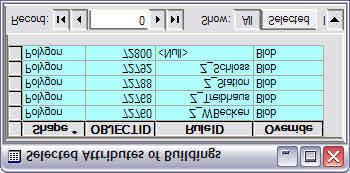
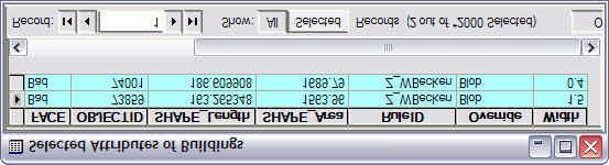
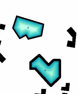
18 What can representations do? Representations can be customized for individual features by overriding properties of the representation rule to improve display. Symbols are offset from their spatial location to avoid conflicts. The rule for one park is changed to not draw trees near the park edges.


19 What can representations do? Making maps with representations can be automated using geoprocessing. Buildings oriented to the nearest linear symbol. Bridges created at intersections and rivers automatically masked.
20 Representation rules
21 Representation rules A representation is a collection of representation rules Convert existing symbology to rules Build new representation rules Rules create and symbolize dynamic geometry independent of spatial geometry Rules can be managed in ArcCatalog or ArcMap Representation rules can be shared using styles
22 Representation fields RuleID field references the representation rule as an integer Override Field Stores feature-specific overrides to the rule Explicit fields Rule properties can be mapped to fields in the feature class

23 Representation rule properties Symbol layers Marker Stroke Fill Geometric effects Dynamically alter display geometry Marker placement styles Place representation markers relative to input geometry Representation rules Representation rule properties


24 Geometric effects and marker placement styles Geometric effects dynamically change display geometry Marker placement styles position markers Along lines and polygon outlines Within polygons In relation to points


25 Link between rules and features
26 Rule properties mapped to fields
27 Editing feature representations
28 Representation overrides Overrides are exceptions to the rules Overrides are made while editing Property Overrides Symbol layer properties Geometric effect properties Marker placement style properties Geometry Overrides Change the shape or position of the feature representation independently of the feature s s geometry

29 Interactive property overrides Representation rule properties of selected feature that can be modified with the Resize tool. Gesture with the Resize tool to resize the selected properties
30 Geometry overrides Edit representation geometry without affecting feature geometry Default database placement Representation geometry moved to resolve conflict (geometry override)

31 Free representations Have an independent rule that can be restructured; change the rule itself not just its properties Access the dynamic geometry primitives, and add new geometry within the feature Use only in exceptional cases because you lose the link to the database
32 Workflow: Refining an existing map Decide which layers in the map could be improved with more control over the symbols Convert the existing symbology of those layers to feature class representations Adjust the representation rules to refine the depiction Map properties to fields to customize Override if necessary Create free representations as a last resort
33 Geoprocessing

34 Cartographic geoprocessing tools Cartography toolbox has four toolsets: Graphic Quality Masking (in 9.1) Representation Management Symbolization Refinement
35 Representation Management toolset Select Feature by Override tool Select features that have property overrides, shape overrides, or both Update Override tool Moves overrides from the Override field into the explicit fields as defined by the representation rule

36 Graphic Quality toolset Detect Graphic Conflict tool Finds areas where dynamic representation symbology overlaps, even when data does not


37 Symbolization Refinement toolset Calculate Polygon Main Angle tool Finds dominant direction of a polygon Create Overpass tool Creates overpass masks and builds parapets
38 Geoprocessing for automation
39 Representation licensing: Desktop ArcGIS Desktop Extensions ArcInfo ArcEditor ArcView ArcReader 3D Analyst (ArcGlobe/ ArcScene) Capability View / Print Representations Yes Yes Yes Yes Yes Define Representation Rules Yes Yes No No No Edit Representations (Overrides) Yes Yes No No No Create/Delete FC Representations Yes Yes No No No Representation GP Tools Yes No No No No
40 Representation licensing Server Embedded Mobile Capability ArcIMS ArcIMS ArcMap Server ArcGIS Server ArcGIS Engine Runtime Engine RT + GDB Update Extension ArcPad View / Print Representations No Yes Yes Yes Yes No Define Representation Rules Edit Representations (Overrides) Create/Delete FC Representations No No Yes No Yes No No No Yes No Yes No No No Yes No Yes No Representation GP Tools No No Yes No No No

41 ESRI Educational Solutions for Cartographic Techniques and Representations Johnstown 2/19 Online 12/11, 2/26 *Additional training locations and dates at ESRI NEARC 41
Slide 1. Advanced Cartography in ArcGIS. Robert Jensen Edie Punt. Technical Workshops
 Slide 1 Technical Workshops Advanced Cartography in ArcGIS Robert Jensen Edie Punt Slide 2 Overview Using representations to manage symbology Solving graphic conflicts Geoprocessing for cartography in
Visualization with ArcGlobe. Brady Hoak
 Visualization with ArcGlobe Brady Hoak Contents What is ArcGlobe? 3D Mapping and ArcGlobe Displaying data in ArcGlobe ArcGlobe tools Tips for constructing ArcGlobe documents New at ArcGIS 9.3 ArcGIS integration
Answer the following general questions: 1. What happens when you right click on an icon on your desktop? When you left double click on an icon?
 Name: Date: June 27th, 2011 GIS Boot Camps For Educators Practical: Explore ArcGIS 10 Desktop Tools and functionality Day_1 Lecture 1 Sources: o ArcGIS Desktop help o ESRI website o Getting to Know ArcGIS
hereby recognizes that Timotej Verbovsek has successfully completed the web course 3D Analysis of Surfaces and Features Using ArcGIS 10
 3D Analysis of Surfaces and Features Using ArcGIS 10 Completed on September 5, 2012 3D Visualization Techniques Using ArcGIS 10 Completed on November 19, 2011 Basics of Map Projections (for ArcGIS 10)
Annotation/Labeling Workshop. Tim Rankin Pat Dolan
 Annotation/Labeling Workshop Tim Rankin Pat Dolan Agenda 8:00am - Introductions 8:05am - Goals of the Workshop 8:15am Labeling 8:45am Annotation Part I 9:15am Break 9:25am Annotation Part II 9:50am Questions
ArcGIS Basics Working with Labels and Annotation
 ArcGIS Basics Working with Labels and Annotation Labeling in ArcGIS has changed considerably from the old ArcView 3.X version. In ArcGIS label positions are generated automatically, are not selectable,
Search & Rescue Map Specifications and Production Workflows
 Search & Rescue Map Specifications and Production Workflows About The Search & Rescue map product and production procedures discussed in this document can be utilized to support search, rescue, and relief
Configuring, Tuning and Managing ArcGIS Server. Dan O Leary James Cardona Owen Evans
 Configuring, Tuning and Managing ArcGIS Server Dan O Leary James Cardona Owen Evans Introductions and Overview Welcome and Thanks for Attending Approach of this Session Share Best Practices and Techniques
Setting Up Your Working Environment
 Setting Up Your Working Environment What are the topics? - Setting Up Your Working Environment - What is a feature class? ArcGIS Program Modules ArcScene ArcGIS ArcGlobe ArcCatalog ArcMap ArcToolbox Program
Esri UC2013. Technical Workshop. Type Presentation Name Here
 Type Presentation Name Here 2013 Esri International User Conference July 8 12, 2013 San Diego, California Technical Workshop 3D Analyst An Introduction Deepinder Deol Michael Contreras Why use 3D GIS?
Streamlining Editing Workflows. Amber Bethell
 Streamlining Editing Workflows Amber Bethell Workflow for solving geographic problems Ask a question Create or acquire data Validate and update data Analyze data Create cartographic product Act upon knowledge
Using the Geodatabase
 Using the Geodatabase February 13, 2002 Presented by: John Stroud, ESRI GeoDatabase Geodatabase comes in two flavors Personal mdb format ArcSDE rdbms format ArcGIS is a suite of three products ArcView,
Integrating CAD Data with ArcGIS
 Integrating CAD Data with ArcGIS Agenda An Overview of CAD Drawings CAD Data Structure in ArcGIS Visualization Georeferencing Data Conversion ArcGIS for AutoCAD Q & A CAD Drawings - Overview Widely used
ArcGIS Desktop The Road Ahead. Amadea Azerki
 ArcGIS Desktop The Road Ahead Amadea Azerki Agenda An Overview of ArcGIS 10 Desktop Enhancements User Interface Mapping Editing Analysis Sharing Q & A ArcGIS 10 Overview Focuses on Usability and Productivity
ArcGIS Pro: Mapping & Visualization. David Watkins, Edie Punt &
 ArcGIS Pro: Mapping & Visualization David Watkins, Edie Punt & Craig Williams @daviddwatkins, @epunt, & @williamscraigm Mapping an Visualization Vision In ArcGIS Pro Improve drawing performance and quality
ArcGIS Pro: What s New in Editing and Data Management
 Federal GIS Conference February 9 10, 2015 Washington, DC ArcGIS Pro: What s New in Editing and Data Management Robert LeClair ArcGIS Pro Overview Esri FedUC 2015 Technical Workshop ArcGIS Pro: What's
ModelBuilder: An Introduction. Kevin Armstrong
 ModelBuilder: An Introduction Kevin Armstrong What is ModelBuilder? A user-friendly way to automate a series of tools Part of the ArcGIS geoprocessing framework - ModelBuilder can run any tool in the ArcToolbox,
Implementing and Optimizing ArcGIS Server Map Caches
 Implementing and Optimizing ArcGIS Server Map Caches Sterling Quinn Jeremy Bartley David Wilcox ESRI Developer Summit 2008 1 Schedule 75 minute session 60 65 minute lecture 10 15 minutes Q & A following
Schematics in ArcMap Tutorial
 Schematics in ArcMap Tutorial Copyright 1995-2010 Esri All rights reserved. Table of Contents Introducing Schematics in ArcMap Tutorial........................ 3 Exercise 1: Getting familiar with Schematics
What's New in ArcGIS 9.2 Service Packs
 What's New in ArcGIS 9.2 Service Packs 18 July 2007 Updated for Service Pack 3 This document describes the main enhancements to 9.2 added by the service packs. It does not cover the bug fixes and quality
Designing and Using Basemaps. Jennifer Hughey
 Designing and Using Basemaps Jennifer Hughey Agenda The ArcGIS System Basemaps are a key component of your system Cartographic design considerations Using basemap layers in ArcMap Best practices for designing
ArcGIS Desktop: Fundamentals of Cartography
 ArcGIS Desktop: Fundamentals of Cartography Outline Symbology Style Files -.style Layer files -.lyr Labeling Label Classes Label Expressions Map Document files -.mxd Map Template files -.mxt Map Elements
Creating Great Labels Using Maplex
 Esri International User Conference San Diego, CA Technical Workshops July 11 15, 2011 Creating Great Labels Using Maplex Craig Williams Natalie Vines 2 Presentation Overview What are the types of text
Exercise 1: Getting to know ArcGIS
 The Scenario You are working for the California Visitor s Commission. You have been asked to prepare a map of California for several dignitaries from out of the country. Your map will need to include enough
ArcGIS 9. Maplex Tutorial
 ArcGIS 9 Maplex Tutorial Copyright 004 006 ESRI All rights reserved. Printed in the United States of America. The information contained in this document is the exclusive property of ESRI. This work is
Nye funktioner i ArcGIS Pro - ArcGIS Pro 2.1
 Nye funktioner i ArcGIS Pro - ArcGIS Pro 2.1 Paulina Karkauskaite GIS Konsulent Paulinak@geoinfo.dk Tlf: +45 53 39 59 16 Niklas Gregersen Presales GIS Konsulent Niklasg@geoinfo.dk Tlf: +45 53 39 59 28
How to Authorise ArcGIS for Desktop 10.2 Single Use
 Welcome to ArcGIS How to Authorise ArcGIS for Desktop 10.2 Single Use This document will help you authorise your Desktop product and any extensions you have purchased for Single Use. You can perform this
ArcGIS Runtime: Styling Maps. Lucas Danzinger and Michael Wilburn
 ArcGIS Runtime: Styling Maps Lucas Danzinger and Michael Wilburn What is this session about? Creating functional maps for your Runtime Apps How to design beautiful and stylish maps with an emphasis on
Introduction to Geodatabase and Spatial Management in ArcGIS. Craig Gillgrass Esri
 Introduction to Geodatabase and Spatial Management in ArcGIS Craig Gillgrass Esri Session Path The Geodatabase - What is it? - Why use it? - What types are there? - What can I do with it? Query Layers
What s s Coming in ArcGIS 10 Desktop
 What s s Coming in ArcGIS 10 Desktop Damian Spangrud ArcGIS Product Manager, ESRI dspangrud@esri.com (or at least turn to silent) ArcGIS 10 A Simple & Pervasive System for Using Maps & Geographic Information
Introduction to ArcGIS I
 Introduction 1-1 What is ArcGIS? ArcGIS Clients ArcReader E X T E N S I O N S ArcGIS Desktop ArcView ArcEditor ArcInfo ArcGIS Engine ArcPad Custom Application E X T E N S I O N S Web Browser Components
ArcMap: Tips and Tricks
 Esri International User Conference San Diego, California Technical Workshops July 23 27, 2012 ArcMap: Tips and Tricks Miriam Schmidts Jorge Ruiz-Valdepena Agenda Navigating ArcMap Repairing data links
3D Analysis Tools and Visualization with ArcGIS. Jie Chang Jinwu Ma
 3D Analysis Tools and Visualization with ArcGIS Jie Chang Jinwu Ma Why 3D GIS? Because our world is 3D Improve understanding 3D is easy for everyone to understand Solve 3D problems Some spatial problems
Display Layers in Geosoft 3D View
 Use the New 2D/3D Workflow features in Target for ArcGIS In Target for ArcGIS version 3.5, there are three new interconnected features that make integrating 2D and 3D data in plan and section maps easier.
Desktop. ArcGIS Server. ArcGIS
 Getting Started with ArcGIS Server Nakul Bhatia and David Crosby ESRI Charlotte 1 Agenda g Overview of ArcGIS Server 9.3.1 Working with GIS Services Using g Web GIS Service Clients ArcGIS Online Map Caching
Developers Road Map to ArcGIS Desktop and ArcGIS Engine
 Developers Road Map to ArcGIS Desktop and ArcGIS Engine Core ArcObjects Desktop Team ESRI Developer Summit 2008 1 Agenda Dev Summit ArcGIS Developer Opportunities Desktop 9.3 SDK Engine 9.3 SDK Explorer
In this exercise, you will convert labels into geodatabase annotation so you can edit the text features.
 Instructions: Use the provided data stored in a USB. For the report: 1. Start a new word document. 2. Follow an exercise step as given below. 3. Describe what you did in that step in the word document
LAB 1: Introduction to ArcGIS 8
 LAB 1: Introduction to ArcGIS 8 Outline Introduction Purpose Lab Basics o About the Computers o About the software o Additional information Data ArcGIS Applications o Starting ArcGIS o o o Conclusion To
Explore some of the new functionality in ArcMap 10
 Explore some of the new functionality in ArcMap 10 Scenario In this exercise, imagine you are a GIS analyst working for Old Dominion University. Construction will begin shortly on renovation of the new
EnvSci360 Computer and Analytical Cartography
 EnvSci360 Computer and Analytical Cartography Lecture 5 Working with Type and Labels Key Points Labels are text that locate and identify features on a map Important for readability & communication EnvSci
ArcGIS Pro. Terminology Guide
 ArcGIS Pro Terminology Guide Essential Terminology or Functionality That s New to ArcGIS Pro ArcGIS Pro Project Map Scene Ribbon Tab on the ribbon View Active view Pane Gallery Task Quick Access Toolbar
Contents What is 3D Mapping Creating g the 3D Dataset Ingredients of a 3D Virtual City Publishing 3D Globes The Road ahead Questions and Answers
 Creating a 3D Virtual City Using ArcGIS Tamrat Belayneh Hardeep Bajwa Contents What is 3D Mapping Creating g the 3D Dataset Ingredients of a 3D Virtual City Publishing 3D Globes The Road ahead Questions
Editing Versioned Geodatabases : An Introduction
 Esri International User Conference San Diego, California Technical Workshops July 24, 2012 Editing Versioned Geodatabases : An Introduction Cheryl Cleghorn Shawn Thorne Assumptions: Basic knowledge of
Chapter 5. Presenting Data
 Chapter 5. Presenting Data Copyright McGraw-Hill Education. Permission required for reproduction or display. 5-1 Map Design Process 5-2 1 About ArcGIS Chapter 5. Presenting Data 5-3 Page layouts and map
ArcGIS Desktop: Making Maps in ArcMap
 ArcGIS Desktop: Making Maps in ArcMap California, Nevada, Hawaii Regional User Group February 6-8, 6 2008 Sacramento, CA Harry J. Moore IV Outline Symbology Style Files -.style Layer files -.lyr Labeling
ArcGIS Runtime: Styling Maps. Ralf Gottschalk, Daniel Lee, Lucas Danzinger
 ArcGIS Runtime: Styling Maps Ralf Gottschalk, Daniel Lee, Lucas Danzinger Map Styling What is this session about? Creating beautiful functional maps for your Runtime Apps - Not about cartography It is
Best Practices for Designing Effective Map Services
 2013 Esri International User Conference July 8 12, 2013 San Diego, California Technical Workshop Best Practices for Designing Effective Map Services Ty Fitzpatrick Tanu Hoque What s in this session Map
ArcGIS Pro Terminology Guide
 ArcGIS Pro Terminology Guide Essential Terminology or Functionality That s New to ArcGIS Pro ArcGIS Pro Project Map Scene Ribbon Tab on the ribbon View Active view Pane Gallery Task Quick Access Toolbar
ArcGIS Pro Terminology Guide
 ArcGIS Pro Terminology Guide Sharing Terminology and User Interface Cross-Reference Share content Project package (.ppkx) Map package (.mpkx) Layer package (.lpkx) Share or publish a web layer Share Web
What s New in Desktop 10.1
 What s New in Desktop 10.1 Damian Spangrud Esri Redlands Trip Down Memory Lane ArcGIS A Complete System for Geographic Information Cloud Web Online Mobile Enterprise Desktop Sharing Information sharing
ArcGIS Pro Editing. Jennifer Cadkin & Phil Sanchez
 ArcGIS Pro Editing Jennifer Cadkin & Phil Sanchez ArcGIS Pro Editing Overview Provides tools that allow you to maintain, update, and create new data - Modifying geometry, drawing new features - Entering
The ArcMap Interface and Using Basic ArcMap Analysis Tools to Create a Map
 The ArcMap Interface and Using Basic ArcMap Analysis Tools to Create a Map *You will need a computer with ESRI ArcGIS Desktop version 9.3 or higher installed* Data Download 1. Save the zipped folder with
ArcGIS Schematics: Automatic Schematic Generation for ArcGIS
 ArcGIS Schematics: Automatic Schematic Generation for ArcGIS An ESRI White Paper May 2005 ESRI 380 New York St., Redlands, CA 92373-8100, USA TEL 909-793-2853 FAX 909-793-5953 E-MAIL info@esri.com WEB
Your Prioritized List. Priority 1 Faulted gridding and contouring. Priority 2 Geoprocessing. Priority 3 Raster format
 Your Prioritized List Priority 1 Faulted gridding and contouring Priority 2 Geoprocessing Priority 3 Raster format Priority 4 Raster Catalogs and SDE Priority 5 Expanded 3D Functionality Priority 1 Faulted
Network Analyst extension. Oi Origin-Destination i (OD) Cost Matrix
 Cost Matrix") Network Analysis in ArcGIS Engine and ArcGIS Desktop (Deep Dive) Michael Rice Matt Crowder Developer Summit 2007 1 General Information Prerequisites General understanding of Network Analyst Knowledge of
Network Analysis in ArcGIS Engine and ArcGIS Desktop (Deep Dive) Michael Rice Matt Crowder Developer Summit 2007 1 General Information Prerequisites General understanding of Network Analyst Knowledge of
Incremental Update of Cartographic Data in a Versioned Environment
 Incremental Update of Cartographic Data in a Versioned Environment Marc-Olivier Briat, Jean-Luc Monnot, Thierry Kressmann ESRI Inc. Redlands, California, USA mbriat@esri.com, jmonnot@esri.com, tkressmann@esri.com
Advanced Map Labeling using Maplex. Wendy Harrison & Samuel Troth
 Advanced Map Labeling using Maplex Wendy Harrison & Samuel Troth Presentation Overview We ll be using ArcGIS Pro Introduction - Different types of text in ArcGIS - role of the Maplex Label Engine labeling
Using ArcGIS. Tracking Analyst. GIS by ESRI
 Using ArcGIS Tracking Analyst GIS by ESRI Copyright (c) 2002 TASC, Inc. and its licensor(s). All Rights Reserved. Printed in the United States of America. The information contained in this document is
PUG List. Raster Analysis 3D Analysis Geoprocessing. Steve Kopp
 PUG List Raster Analysis 3D Analysis Geoprocessing Steve Kopp Contour Polygons Spatial Analyst - color-filled contours. Similar to thematic classification, where blue = -1000 to zero, and red = 0 to +1000,
ArcGIS for Developers. Kevin Deege Educational Services Washington DC
 ArcGIS for Developers Kevin Deege Educational Services Washington DC Introductions Who am I? Who are you? ESRI Product Development Experience? What development languages are you using? What types of applications
ArcGIS 10.1 for Desktop Artie Robinson
 ArcGIS 10.1 for Desktop Artie Robinson ArcGIS A Complete System for Geographic Information Cloud Web Online Mobile Enterprise Desktop Name Change Name Prior to 10.1 ArcGIS Desktop ArcInfo ArcEditor ArcView
Welcome to NR402 GIS Applications in Natural Resources. This course consists of 9 lessons, including Power point presentations, demonstrations,
 Welcome to NR402 GIS Applications in Natural Resources. This course consists of 9 lessons, including Power point presentations, demonstrations, readings, and hands on GIS lab exercises. Following the last
What's New in ArcGIS 9.2 Service Packs
 What's New in ArcGIS 9.2 Service Packs 8 July 2008 Updated for Service Pack 6 This document describes the main enhancements to 9.2 added by the service packs. It does not cover the bug fixes and quality
ArcGIS Pro Editing: An Introduction. Jennifer Cadkin & Phil Sanchez
 ArcGIS Pro Editing: An Introduction Jennifer Cadkin & Phil Sanchez See Us Here WORKSHOP ArcGIS Pro Editing: An Introduction LOCATION SDCC - Ballroom 20 D TIME FRAME Thursday 10:00 11:00 ArcGIS Pro: 3D
ArcGIS Desktop: Introduction to Geoprocessing with ModelBuilder Kevin Armstrong ESRI
 ArcGIS Desktop: Introduction to Geoprocessing with ModelBuilder Kevin Armstrong ESRI SERUG 2008 1 What is ModelBuilder? A user-friendly way to automate a series of tools Part of the ArcGIS geoprocessing
ArcMap Editing Tips and Tricks. Sean Jones
 ArcMap Editing Tips and Tricks Sean Jones Overview Topics - Tuning your editing map - Creating features - Editing features and attributes - Aligning and editing coincident features - Addins Format - Software
Creating, managing and utilizing a 3D Virtual City in ArcGIS Tamrat Belayneh Eric Wittner
 Creating, managing and utilizing a 3D Virtual City in ArcGIS 10.1 Tamrat Belayneh (tbelayneh@esri.com) Eric Wittner (ewittner@esri.com ) Contents 3D Mapping & Ingredients of a 3D Virtual City Creating
GIS IN ECOLOGY: CREATING RESEARCH MAPS
 GIS IN ECOLOGY: CREATING RESEARCH MAPS Contents Introduction... 2 Elements of Cartography... 2 Course Data Sources... 3 Tasks... 3 Establishing the Map Document... 3 Laying Out the Map... 5 Exporting Your
Getting the most from the Maplex Label Engine
 Esri International User Conference San Diego, California Technical Workshops July 26, 2012 Getting the most from the Maplex Label Engine Craig Williams Natalie Matthews 2 Presentation Overview What are
Introduction to ArcGIS Desktop
 Introduction to ArcGIS Desktop Prepared by David R. Maidment Center for Research in Water Resources University of Texas at Austin September 2011 Contents Goals of the Exercise Computer and Data Requirements
Finding Your Way with ArcGIS Network Analyst. Frederic Schettini Michael Rice
 Finding Your Way with ArcGIS Network Analyst Frederic Schettini Michael Rice Agenda Introduction to Network Analyst Working with ArcGIS Engine Working with ArcGIS Server Support & Resources Questions ArcGIS
Working with Feature Layers. Russell Brennan Gary MacDougall
 Working with Feature Layers Russell Brennan Gary MacDougall Working with Feature Layers Session will focus on feature access and editing Highlight new features added over the last few releases Agenda Introduction
What should y you expect in this session? Basic to advanced topics Outline What is map caching? Why should I cache? Caching workflow How to create a c
 Designing, Deploying, and Using Cached Map Services David Crosby & Craig Mesimer What should y you expect in this session? Basic to advanced topics Outline What is map caching? Why should I cache? Caching
3D Analyst Visualization with ArcGlobe. Brady Hoak, ESRI DC
 3D Analyst Visualization with ArcGlobe Brady Hoak, ESRI DC 3D GIS Viewing geospatial data in 3D leads to new insights 2D 3D Sometimes you need to edit your data in 3D 2D 3D Some problems can only be solved
Editing Data with ArcGIS for Desktop. Student Edition
 Editing Data with ArcGIS for Desktop Student Edition Copyright 2014 Esri All rights reserved. Course version 3.0. Version release date December 2014. Printed in the United States of America. The information
Esri Production Mapping An Introduction
 Esri International User Conference San Diego, California Technical Workshops July 25, 2012 Esri Production Mapping An Introduction Lana Tylka Amber Bethell Workshop Overview Part I - Industry challenges
Implementing Versioned Workflows in a Multiuser Geodatabase. Student Edition
 Implementing Versioned Workflows in a Multiuser Geodatabase Student Edition Copyright 2016 Esri All rights reserved. Course version 4.0. Version release date March 2016. Printed in the United States of
ArcGIS Pro: Effective License Management. Stephanie Wendel Melanie Summers Rob Elkins
 ArcGIS Pro: Effective License Management Stephanie Wendel Melanie Summers Rob Elkins Effective License Management Licensing Model Key Concepts Setting Up and Managing your Organization Grouping Users How
ArcGIS Runtime SDK for WPF
 Esri Developer Summit in Europe November 9 th Rotterdam ArcGIS Runtime SDK for WPF Mike Branscomb Mark Baird Agenda Introduction SDK Building the Map Query Spatial Analysis Editing and Geometry Programming
Create a personal geodatabase
 Create a personal geodatabase To create a personal geodatabase that corresponds to the same release as the ArcGIS for Desktop client you are using, follow these steps: 1. In ArcCatalog, right-click the
Initial Analysis of Natural and Anthropogenic Adjustments in the Lower Mississippi River since 1880
 Richard Knox CE 394K Fall 2011 Initial Analysis of Natural and Anthropogenic Adjustments in the Lower Mississippi River since 1880 Objective: The objective of this term project is to use ArcGIS to evaluate
ArcGIS 9. Using ArcCatalog
 ArcGIS 9 Using ArcCatalog Copyright 1999, 2003 2005 ESRI All rights reserved. Printed in the United States of America. The information contained in this document is the exclusive property of ESRI. This
From 2D to 3D at Esri
 From 2D to 3D at Esri OGC/EuroSDR workshop on CityGML in National Mapping Paul Hardy phardy@esri.com Business Development Consultant National Mapping & Cadastre Esri 3D GIS Visualize Manage Share Analyze
Encoded URLs in hyperlinks. TerraGo Publisher for ArcGIS TerraGo Publisher for ArcGIS Server TerraGo Arc2Edge Version 7.3.
 TerraGo Publisher for ArcGIS TerraGo Publisher for ArcGIS Server TerraGo Arc2Edge Version 7.3.1, December 2017 What is TerraGo Publisher for ArcGIS? What is TerraGo Arc2Edge? What s new in this release?
By Colin Childs, ESRI Education Services. Catalog
 s resolve many traditional raster management issues By Colin Childs, ESRI Education Services Source images ArcGIS 10 introduces Catalog Mosaicked images Sources, mosaic methods, and functions are used
ArcGIS 4: Sharing Content on the Web STUDENT EDITION
 ArcGIS 4: Sharing Content on the Web STUDENT EDITION Copyright 2016 Esri All rights reserved. Course version 3.1.1. Version release date July 2016. Printed in the United States of America. The information
Topology in the Geodatabase an Introduction. Erik Hoel Doug Morgenthaler
 Topology in the Geodatabase an Introduction Erik Hoel Doug Morgenthaler ESRI Super Secret Topology Laboratory, May 2012 Agenda ArcGIS Topology defined Validating a topology Editing a topology Geoprocessing
ArcGIS 9. Using ArcCatalog
 ArcGIS 9 Using ArcCatalog Copyright 1999, 2003 2004 ESRI All rights reserved. Printed in the United States of America. The information contained in this document is the exclusive property of ESRI. This
for ArcSketch Version 1.1 ArcSketch is a sample extension to ArcGIS. It works with ArcGIS 9.1
 ArcSketch User Guide for ArcSketch Version 1.1 ArcSketch is a sample extension to ArcGIS. It works with ArcGIS 9.1 ArcSketch allows the user to quickly create, or sketch, features in ArcMap using easy-to-use
ESRI Technology Update. Joe Holubar Larry Young
 ESRI Technology Update Joe Holubar Larry Young Continued Improvement Improving Quality and Extending and Refining Functionality First Half of 2009: Minor Update Release (ArcGIS 9.3.1) ArcGIS Explorer Fall
Migrating from ArcMap to ArcGIS Pro. David Watkins Scott Noulis
 Migrating from ArcMap to ArcGIS Pro David Watkins Scott Noulis Getting Started with ArcGIS Pro ArcGIS Pro 64 bit, multi-threaded Simplified user interface Integrated with the ArcGIS platform Combined 2D/3D
Lesson 8 : How to Create a Distance from a Water Layer
 Created By: Lane Carter Advisor: Paul Evangelista Date: July 2011 Software: ArcGIS 10 Lesson 8 : How to Create a Distance from a Water Layer Background This tutorial will cover the basic processes involved
3D Data Modelling at Esri. Paul Hardy Business Development Consultant Esri Europe
 3D Data Modelling at Esri Paul Hardy phardy@esri.com Business Development Consultant Esri Europe Users of 3D GIS Local government Facilities management Civil engineering 3D GIS Defense / Public Safety
Geographical Information Systems Institute. Center for Geographic Analysis, Harvard University. LAB EXERCISE 1: Basic Mapping in ArcMap
 Harvard University Introduction to ArcMap Geographical Information Systems Institute Center for Geographic Analysis, Harvard University LAB EXERCISE 1: Basic Mapping in ArcMap Individual files (lab instructions,
Building 3D models with the horizons method
 ARC HYDRO GROUNDWATER TUTORIALS SUBSURFACE ANALYST Building 3D models with the horizons method Arc Hydro Groundwater (AHGW) is a geodatabase design for representing groundwater datasets within ArcGIS.
Creating 2D Map Caches with
 Creating 2D Map Caches with ArcGIS Server 9.2 Presented by: The multi-threaded, threaded, over-clocked, dual core Diplo Matt Still AND the fast, the furious, the fully cached, Jonathan Fisk ArcGIS Server
Copyright information. U.S. Government Restricted/Limited Rights. ESRI Trademarks. Copyright ESRI All rights reserved
 Copyright 1999-2007 ESRI All rights reserved Copyright information The information contained in this document is the exclusive property of ESRI and its licensor(s). This work is protected under United
ArcGIS ArcMap and Cartography Part 3. Second Screen: Have a cool map open on the second screen and the Washington DC map (minimized).
.") ArcGIS ArcMap and Cartography Part 3 First slide on the screen as people walk in. Second Screen: Have a cool map open on the second screen and the Washington DC map (minimized). 1 Map Composition and Page
ArcGIS ArcMap and Cartography Part 3 First slide on the screen as people walk in. Second Screen: Have a cool map open on the second screen and the Washington DC map (minimized). 1 Map Composition and Page
Enabling High-Quality Printing in Web Applications. Tanu Hoque & Scott Moore
 Enabling High-Quality Printing in Web Applications Tanu Hoque & Scott Moore High Quality Printing on the Web Create a printable document (PDF preferably) Have that document printed to exact scale Leverage
Lecture 7 Digitizing. Dr. Zhang Spring, 2017
 Lecture 7 Digitizing Dr. Zhang Spring, 2017 Model of the course Using and making maps Navigating GIS maps Map design Working with spatial data Geoprocessing Spatial data infrastructure Digitizing File