Chapter 5. Presenting Data
|
|
|
- Shona Knight
- 5 years ago
- Views:
Transcription

1 Chapter 5. Presenting Data Copyright McGraw-Hill Education. Permission required for reproduction or display. 5-1 Map Design Process 5-2 1
2 About ArcGIS Chapter 5. Presenting Data 5-3 Page layouts and map scales 5-4 2


3 ArcMap Views ArcMap has two main views: Data View - for composing your map Layout View - for composing your layout Use View Menu to switch between them 5-5 Data View Layout Tools NOT Active 5-6 3
 5-7 Map layouts For creating hard")

4 Layout View Layout Tools Active Page Visible Rulers Visible (if turned on) 5-7 Map layouts For creating hard copy maps Place data frames, titles, legends, scales, north arrows Include tables and graphs Add images or logos 5-8 4


5 The Layout toolbar Zoom tools Pan Fit page Zoom Fixed In/Out Previous/ Next Extent Enlarge Change Layout Actual Size 5-9 Use Tools toolbar to adjust map extent inside the data frame Using zoom tools Use Layout toolbar to adjust page inside the ArcMap window


6 Steps to Layouts Planning the map Setting up the map page and data frames Adding a legend Adding a scale bar Adding titles and text Adding objects Adding neatlines and backgrounds Adding graphics Printing the map 5-11 Visioning the map page Paper size? Landscape or Portrait? Data frames Size and position? Map scale? Margins Grid for aligning features


7 Ways to set up the map Use a predefined map template when starting the map Set up the page size, data frames and other elements yourself Switch to another template after the map has been created 5-13 Templates: Assigning frames


8 The Page and Print Setup menu 5-15 Click and drag active frame to move/change size Composing frames Or set size and location explicitly


9 Units terminology Map units are determined by the data frame coordinate system. Display units can be set by the user, so that the coordinates may be viewed in any desired unit, such as miles. Page units show the location on the map page layout, usually in inches or cm Scale bar shows current scale as you zoom in/out Set display units in data frame properties Position bar shows current location of cursor Display units


10 Setting the display units 5-20 Labeling and annotation

11 Labeling Options Dynamic labels (introduced in Chapter 2) Layer property set for each layer Placed automatically for an entire layer Graphic text Simple graphics placed/edited on layout Saved as part of map document Annotation Usually created from dynamic labels Can be saved and edited for exact placement 5-22 Dynamic labels


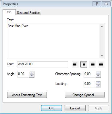
12 Graphic text Accessible in the Drawing Toolbar Graphic text must be placed in Layout View Set font/size with Draw toolbar 5-24 Multi-line labels
13 Annotation Can be created from dynamic labels then edited individually Provides precise control of each label Can be stored two ways As text in the map document Can be used only within that map document Simple editing using the Draw toolbar As a feature class in a geodatabase ** Can be used in many map documents Requires using the Editor to move and change This is an annotation feature class (text with spatial location) 5-27 Default label scaling Sizes of labels and symbols are specified when they are created. By default, they remain the same size as the user zooms in and out. If specified as 10 pt. labels, they are always 10 pt. labels

14 The reference scale Alternately, symbols and text can change size when the user zooms in or out. The reference scale is the scale at which symbols will appear at their assigned size. If a reference scale is set, then symbols and text change size when the map scale changes. They only appear at their assigned size if the map scale once again matches the reference scale Adding map elements


15 Adding a legend Opens the Legend Wizard 5-36 The Legend Wizard Choose layers to include Set title and font


16 Legend Wizard Add frame border and shading Set patch size and type 5-38 Legend Wizard Right-click legend to open properties and modify it. Set spacing between elements (usually leave defaults) Finished!


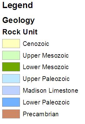


17 Legend Styles 5-40 Changing the legend style Legend terms


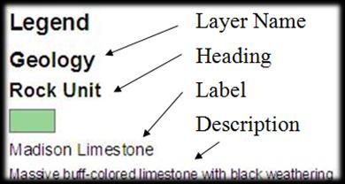
18 Managing legend styles In the Table of Contents Layer Name Heading Label Description In the Symbology properties Where to make text changes that appear in the legend Adding a scale bar Subdivision Division Division unit Scale bar size is determined by division settings and the map scale


19 Options when resizing scale bar If the scale changes, so must the scale bar Adjust division value Zoom out Adjust width Adjust number of divisions


20 Adding north arrow 5-46 Creating frame grids Use Data Frame Properties Window Opens Grid and Graticules Wizard


21 Grids and Graticules Wizard In Data Frame Properties 5-48 Text and titles


22 Pictures 5-50 Neatlines Border around all map elements

23 Graphics The Draw toolbar Select Elements Shapes Font style Graphic text tools Font Colors for fill, lines, markers 5-52 Reviewing and printing


24 Printing maps Not ready to print! 5-54 Export as PDF or image file
USING DATA DRIVEN PAGES
 USING DATA DRIVEN PAGES Mid-West ESRI Utility User s Group Conference March 26, 2014 Presented by: Hillary Bjorstrom, GIS Analyst STAR Energy Services LLC Alexandria, Minnesota EXERCISE 1 CREATING A GRID
Lecture 6 MAP DESIGN: PART II. Map Elements, Cartography, Text, Annotation, Labels and Graphics
 Lecture 6 MAP DESIGN: PART II Map Elements, Cartography, Text, Annotation, Labels and Graphics Outline What is a good map? Things to think about when making a map Design Process Map Elements Labels Annotation
Review of File Management and Introduction to ArcGIS
 Review of File Management and Introduction to ArcGIS RNR/GEOG 417/517 Overview of Presentation Discuss the objectives of the lab exercise Introduce the class directory structure General file policies Introduce
Making a Sackville Coastal Flood Map
 Making a Sackville Coastal Flood Map Demo covers: Accessing and previewing map templates Modifying map elements such as titles, data frames, legends & scale bars Drawing a graphic on a map Adding text
GIS Virtual Workshop: Creating a Final Map
 To create a map that will be pleasing to an end user, in a static format requires that certain items be added to the map such as a direction arrow, scale, title and legend. Including this information on
ArcGIS Desktop: Fundamentals of Cartography
 ArcGIS Desktop: Fundamentals of Cartography Outline Symbology Style Files -.style Layer files -.lyr Labeling Label Classes Label Expressions Map Document files -.mxd Map Template files -.mxt Map Elements
ArcGIS ArcMap and Cartography Part 3. Second Screen: Have a cool map open on the second screen and the Washington DC map (minimized).
.") ArcGIS ArcMap and Cartography Part 3 First slide on the screen as people walk in. Second Screen: Have a cool map open on the second screen and the Washington DC map (minimized). 1 Map Composition and Page
ArcGIS ArcMap and Cartography Part 3 First slide on the screen as people walk in. Second Screen: Have a cool map open on the second screen and the Washington DC map (minimized). 1 Map Composition and Page
Org Chart Designer Pro
 Org Chart Designer Pro User Guide Version 3.73 Last updated: Feb 12, 2016 Table of Contents Editor overview How to add from template File save format Format colors Update line thickness and line pattern
Intro to GIS (requirements: basic Windows computer skills and a flash drive)
") Introduction to GIS Intro to GIS (requirements: basic Windows computer skills and a flash drive) Part 1. What is GIS. 1. System: hardware (computers, devices), software (proprietary or free), people. 2.
Introduction to GIS Intro to GIS (requirements: basic Windows computer skills and a flash drive) Part 1. What is GIS. 1. System: hardware (computers, devices), software (proprietary or free), people. 2.
Map Making Tutorial Jennifer Ailshire June 25, Adding Data to the Map and Saving the Map
 Map Making Tutorial Jennifer Ailshire June 25, 2008 Adding Data to the Map and Saving the Map Click on the Add Data button, browse to the appropriate directory and select the desired file(s). After you
Mid-West ESRI Utility User s Group Conference. March 26, 2014
 Mid-West ESRI Utility User s Group Conference March 26, 2014 Presented by: Hillary Bjorstrom, GIS Analyst STAR Energy Services LLC 1 What are Data Driven Pages? Data Driven Pages Workflow Creating an Index
ArcGIS Desktop: Making Maps in ArcMap
 ArcGIS Desktop: Making Maps in ArcMap California, Nevada, Hawaii Regional User Group February 6-8, 6 2008 Sacramento, CA Harry J. Moore IV Outline Symbology Style Files -.style Layer files -.lyr Labeling
Geographical Information Systems Institute. Center for Geographic Analysis, Harvard University. LAB EXERCISE 1: Basic Mapping in ArcMap
 Harvard University Introduction to ArcMap Geographical Information Systems Institute Center for Geographic Analysis, Harvard University LAB EXERCISE 1: Basic Mapping in ArcMap Individual files (lab instructions,
Reference Services Division Presents. Microsoft Word 2
 Reference Services Division Presents Microsoft Word 2 This handout covers the latest Microsoft Word 2010. This handout includes instructions for the tasks we will be covering in class. Basic Tasks Review
GIS IN ECOLOGY: CREATING RESEARCH MAPS
 GIS IN ECOLOGY: CREATING RESEARCH MAPS Contents Introduction... 2 Elements of Cartography... 2 Course Data Sources... 3 Tasks... 3 Establishing the Map Document... 3 Laying Out the Map... 5 Exporting Your
Tutorial 2: Modifying the Data Displayed in ArcGIS
 Tutorial 2: Modifying the Data Displayed in ArcGIS For this tutorial, download the facilities listed in the Toxic Release Inventory from TOXMAP and the New Jersey county boundaries from the New Jersey
Using ArcGIS 10.x Introductory Guide University of Toronto Mississauga Library Hazel McCallion Academic Learning Centre
 Using ArcGIS 10.x Introductory Guide University of Toronto Mississauga Library Hazel McCallion Academic Learning Centre FURTHER ASSISTANCE If you have questions or need assistance, please contact: Andrew
Tutorial 9: Creating Layout Plans and Printing
 Tutorial 9: Creating Layout Plans and Printing Tutorial Content 9.1. What is the layout view and how is this different to the data view? 9.2. How do I set out a map for printing in ArcMap? 9.3. What tools
Press the Plus + key to zoom in. Press the Minus - key to zoom out. Scroll the mouse wheel away from you to zoom in; towards you to zoom out.
 Navigate Around the Map Interactive maps provide many choices for displaying information, searching for more details, and moving around the map. Most navigation uses the mouse, but at times you may also
Overview of ArcGIS Online Applications. Champaign County
 Overview of ArcGIS Online Applications Champaign County Champaign County GIS Consortium Updated: April 2017 Table of Contents ArcGIS Online Application Overview... 3 Map Interface Symbology and Terminology...
Reference Services Division Presents. Microsoft Word 2
 Reference Services Division Presents Microsoft Word 2 Welcome to Word 2. This handout includes step-by-step instructions for each of the tasks we will be covering in class. Changes to Word 2007 There are
Activity: Using Mapbook
 Activity: Using Mapbook Requirements You must have ArcMap for this activity. Preparation: Download Mapbook. The download page is intimidating. Just scroll to the bottom and find the Download Now place.
JASCO CANVAS PROGRAM OPERATION MANUAL
 JASCO CANVAS PROGRAM OPERATION MANUAL P/N: 0302-1840A April 1999 Contents 1. What is JASCO Canvas?...1 1.1 Features...1 1.2 About this Manual...1 2. Installation...1 3. Operating Procedure - Tutorial...2
In this exercise, you will convert labels into geodatabase annotation so you can edit the text features.
 Instructions: Use the provided data stored in a USB. For the report: 1. Start a new word document. 2. Follow an exercise step as given below. 3. Describe what you did in that step in the word document
Geography 281 Map Making with GIS Project Two: Map Design Issues in ArcMap
 Geography 281 Map Making with GIS Project Two: Map Design Issues in ArcMap This activity provides an introduction to the map design process. It takes you through a typical sequence from the initial decision
Guide to Editing Map Legends
 Guide to Editing Map Legends Map legends explain map symbols and are crucial to the communication of a map s message. Effective legends are created with careful consideration of labels and text, classes,
Exercise 1: An Overview of ArcMap and ArcCatalog
 Exercise 1: An Overview of ArcMap and ArcCatalog Introduction: ArcGIS is an integrated collection of GIS software products for building a complete GIS. ArcGIS enables users to deploy GIS functionality
Labels and Envelopes in Word 2013
 Labels and Envelopes in Word 2013 Labels... 2 Labels - A Blank Page... 2 Selecting the Label Type... 2 Creating the Label Document... 2 Labels - A Page of the Same... 3 Printing to a Specific Label on
Libre Writer Exercise - 4
 Libre Writer Exercise - 4 Aim: Introduction to Writer, importance of Writer as Word Processor, overview of toolbars, saving, accessing files, using help and resources. i). Create a document using the features:
Advanced PDF features
 1 of 7 2/17/2009 10:56 PM Show Navigation Hide Navigation You are here: Mapping and v isualization > Page layout and map composition > Map output Advanced PDF features Release 9.3 Last modified November
Georeferencing Soil Maps in ArcMap 10.x: Basic procedures to download, open, manipulate and print spatial data
 Georeferencing Soil Maps in ArcMap 10.x: Basic procedures to download, open, manipulate and print spatial data These procedures outline: A. Obtaining soil maps. B. Downloading boundary files. C. Uncompressing
Getting Started with GIS using ArcGIS 10.6 What is GIS? and - Module 1 Creating a map document
 Getting Started with GIS using ArcGIS 10.6 What is GIS? and - Module 1 Creating a map document Marcel Fortin Map & Data Library mdl@library.utoronto.ca 2018 http://mdl.library.utoronto.ca This workshop
MS Word Professional Document Alignment
 MS Word Professional Document Alignment Table of Contents CHARACTER VS. PARAGRAPH FORMATTING...5 Character formatting...5 Paragraph Formatting...5 USING SHOW/HIDE TO REVEAL NON-PRINTING CHARACTERS...5
The ArcMap Interface and Using Basic ArcMap Analysis Tools to Create a Map
 The ArcMap Interface and Using Basic ArcMap Analysis Tools to Create a Map *You will need a computer with ESRI ArcGIS Desktop version 9.3 or higher installed* Data Download 1. Save the zipped folder with
Visual Studies Exercise.Topic08 (Architectural Paleontology) Geographic Information Systems (GIS), Part I
 Geographic Information Systems (GIS), Part I") ARCH1291 Visual Studies II Week 8, Spring 2013 Assignment 7 GIS I Prof. Alihan Polat Visual Studies Exercise.Topic08 (Architectural Paleontology) Geographic Information Systems (GIS), Part I Medium: GIS
ARCH1291 Visual Studies II Week 8, Spring 2013 Assignment 7 GIS I Prof. Alihan Polat Visual Studies Exercise.Topic08 (Architectural Paleontology) Geographic Information Systems (GIS), Part I Medium: GIS
Overview: Printing MFworks Documents
 Overview: Printing MFworks Documents The Layout Window Printing Printing to Disk Overview: Printing MFworks Documents MFworks is designed to print to any standard Windows compatible printer this includes
Picture Package and Custom Package
 Picture Package and Custom Package How to create custom layouts in the Print module By Martin Evening Picture Package and Custom Package In addition to the Single Image/Contact Sheet options, there is
Desktop Publishing (Word)
") Desktop Publishing (Word) In addition to word processing, Microsoft Word is a suprisingly capable desktop publishing application. It is no substitute for a professional grade program like Adobe PageMaker
Desktop Publishing (Word) In addition to word processing, Microsoft Word is a suprisingly capable desktop publishing application. It is no substitute for a professional grade program like Adobe PageMaker
Explore some of the new functionality in ArcMap 10
 Explore some of the new functionality in ArcMap 10 Scenario In this exercise, imagine you are a GIS analyst working for Old Dominion University. Construction will begin shortly on renovation of the new
From Data to Map in 30 Minutes. Aileen Buckley, PhD
 From Data to Map in 30 Minutes Aileen Buckley, PhD This session Crater Lake online map From NPS: https://www.nps.gov/carto/hfc/carto/media/crlamap1.pdf Download Crater Lake map packages here: ArcGIS Pro
Map Preparation. Using QGIS
 Map Preparation Using QGIS Tutorial ID: IGET_GIS_006 This tutorial has been developed by BVIEER as part of the IGET web portal intended to provide easy access to geospatial education. This tutorial is
A Step-by-step guide to creating a Professional PowerPoint Presentation
 Quick introduction to Microsoft PowerPoint A Step-by-step guide to creating a Professional PowerPoint Presentation Created by Cruse Control creative services Tel +44 (0) 1923 842 295 training@crusecontrol.com
To learn more about the Milestones window choose: Help Help Topics Select the Index tab and type in the feature. For Example toolbox.
 To learn more about the Milestones window choose: Help Help Topics Select the Index tab and type in the feature. For Example toolbox. 1 of 12 CHOOSE THE DATES TAB TO: 1. Set the schedule s Date Range.
Municipal Connect TM GIS Viewer
 Municipal Property Assessment Corporation 1305 Pickering Parkway Pickering, ON L1V 3P2 For further information please contact your local MPAC Municipal Relations Representative. Municipal Connect TM GIS
Step by Step GIS. Section 1
 Step by Step GIS Section 1 Contact the web page given below for the data required to do the exercises (http://www.pasda.psu.edu/default.asp) Before beginning the tutorials please visit the Preparation
Develop great research posters using Microsoft PowerPoint
 www.qps.qut.edu.au Develop great research posters using Microsoft PowerPoint A step-by-step guide QUT PRINTING SERVICES A step-by-step guide This step-by-step guide will assist you to understand the purpose
Layout. Usual menu tabs. Top toolbar. Right toolbar. Left toolbar. Work area
 Layout Top toolbar Usual menu tabs Left toolbar Right toolbar Work area Layout - left toolbar Contains tools like textbox, mediabox, line etc. Textbox tool Mediabox tool Layout - top toolbar Edit size,
Week 5 Creating a Calendar. About Tables. Making a Calendar From a Table Template. Week 5 Word 2010
 Week 5 Creating a Calendar About Tables Tables are a good way to organize information. They can consist of only a few cells, or many cells that cover several pages. You can arrange boxes or cells vertically
Using SymPrint to Make Overlays, Templates & More...
 Welcome to SymPrint SymPrint is an easy-to-use tool for creating communication overlays, worksheets, classroom activities and more using a modern toolbar and common-sense interface modeled after the programs
You can link completely different files into one by adopting a file to one or more of your topics.
 FILE INSPIRATION MENUs Inspiration 1 The FILE menu lists many of the operations,or functions, that you are familiar with, such as New, Open, Save, Print, and so on. Operations that are unique to Inspiration
City of La Crosse Online Mapping Website Help Document
 City of La Crosse Online Mapping Website Help Document This document was created to assist in using the new City of La Crosse online mapping sites. When the website is first opened, a map showing the City
Kriging Great Lakes Sediment Contamination Values Cookbook for ArcGIS 10.x
 Kriging Great Lakes Sediment Contamination Values Cookbook for ArcGIS 10.x By Michael Dennis, K. Wayne Forsythe, Cameron Hare, and Adrian Gawedzki 2004-2012 To reference this document: Dennis, M., K.W.
Microsoft Office PowerPoint 2013 Courses 24 Hours
 Microsoft Office PowerPoint 2013 Courses 24 Hours COURSE OUTLINES FOUNDATION LEVEL COURSE OUTLINE Using PowerPoint 2013 Opening PowerPoint 2013 Opening a Presentation Navigating between Slides Using the
InDesign CC 2014 Essential Skills
 InDesign CC 2014 Essential Skills Adobe InDesign Creative Cloud 2014 University Information Technology Services Training, Outreach, Learning Technologies & Video Production Copyright 2015 KSU Division
Microsoft Office Word 2016 for Mac
 Microsoft Office Word 2016 for Mac Formatting Your Document University Information Technology Services Learning Technologies, Training & Audiovisual Outreach Copyright 2016 KSU Division of University Information
Microsoft Word 2010 Basics
 1 Starting Word 2010 with XP Click the Start Button, All Programs, Microsoft Office, Microsoft Word 2010 Starting Word 2010 with 07 Click the Microsoft Office Button with the Windows flag logo Start Button,
GPS TO GIS EXERCISE (30 PTS)
") GPS TO GIS EXERCISE (30 PTS) This exercise will allow you to demonstrate your cumulative knowledge of using a GPS receiver to collect data with locational information, downloading this data to a desktop
GPS TO GIS EXERCISE (30 PTS) This exercise will allow you to demonstrate your cumulative knowledge of using a GPS receiver to collect data with locational information, downloading this data to a desktop
The Newsletter will contain a Title for the newsletter, a regular border, columns, Page numbers, Header and Footer and two images.
 Creating the Newsletter Overview: You will be creating a cover page and a newsletter. The Cover page will include Your Name, Your Teacher's Name, the Title of the Newsletter, the Date, Period Number, an
Working with PowerPoint. Modify PowerPoint. Views
 Working with PowerPoint The new user interface The Backstage view The Office Ribbon with its tabs The Quick Access Toolbar The Status Bar How to Use Smart Tags The New File Format Live Preview Protected
Word 3 Microsoft Word 2013
 Word 3 Microsoft Word 2013 Mercer County Library System Brian M. Hughes, County Executive Action Technique 1. Insert a Text Box 1. Click the Insert tab on the Ribbon. 2. Then click on Text Box in the Text
Creating Business Cards With LibreOffice
 Creating Business Cards With LibreOffice by Len Nasman, Bristol Village Ohio Computer Club Copyright 2018 ~ may be copied with permission The illustrations in this document were created using LibreOffice
LAB EXERCISE #1 (25pts)
") Grossmont College Introduction to Geographic Information Science Name: Instructors: Judd Curran & Mark Goodman 1 LAB EXERCISE #1 (25pts) ArcGIS Map Projection on the Fly: Working with: U.S. Map illustrating
Grossmont College Introduction to Geographic Information Science Name: Instructors: Judd Curran & Mark Goodman 1 LAB EXERCISE #1 (25pts) ArcGIS Map Projection on the Fly: Working with: U.S. Map illustrating
Microsoft Word Important Notice
 Microsoft Word 2013 Important Notice All candidates who follow an ICDL/ECDL course must have an official ICDL/ECDL Registration Number (which is proof of your Profile Number with ICDL/ECDL and will track
Introducing Gupta Report Builder
 Business Reporting Chapter 1 Introducing Gupta Report Builder You can use Report Builder to design reports. This chapter describes: Our approach to building reports. Some of the reports you can build.
Session 3: Cartography in ArcGIS. Mapping population data
 Exercise 3: Cartography in ArcGIS Mapping population data Background GIS is well known for its ability to produce high quality maps. ArcGIS provides useful tools that allow you to do this. It is important
InDesign CC 2014 Intermediate Skills
 InDesign CC 2014 Intermediate Skills Adobe InDesign Creative Cloud 2014 University Information Technology Services Training, Outreach, Learning Technologies & Video Production Copyright 2016 KSU Division
Lehigh University Library & Technology Services
 Lehigh University Library & Technology Services Start Word Open a file called day2 Microsoft WORD 2003 Day 2 Click the Open button on the Standard Toolbar Go to the A: drive and highlight day2 and click
Faculty Development Seminar Series Constructing Posters in PowerPoint 2003 Using a Template
 2008-2009 Faculty Development Seminar Series Constructing Posters in PowerPoint 2003 Using a Template Office of Medical Education Research and Development Michigan State University College of Human Medicine
Labeling, Annotation, Editing, and Text Placement with ArcGIS. Ralph Denkenberger
 Labeling, Annotation, Editing, and Text Placement with ArcGIS Ralph Denkenberger Overview Define labels & annotation Work with labels Convert labels to annotation Work with annotation Questions 2 Map has
Microsoft Office Excel
 Microsoft Office 2007 - Excel Help Click on the Microsoft Office Excel Help button in the top right corner. Type the desired word in the search box and then press the Enter key. Choose the desired topic
Name: Date: June 27th, 2011 GIS Boot Camps For Educators Lecture_3
 Name: Date: June 27th, 2011 GIS Boot Camps For Educators Lecture_3 Practical: Creating and Editing Shapefiles Using Straight, AutoComplete and Cut Polygon Tools Use ArcCatalog to copy data files from:
Designer Reference 1
 Designer Reference 1 Table of Contents USE OF THE DESIGNER...4 KEYBOARD SHORTCUTS...5 Shortcuts...5 Keyboard Hints...5 MENUS...7 File Menu...7 Edit Menu...8 Favorites Menu...9 Document Menu...10 Item Menu...12
Microsoft Word (97, 98, 2000) Word Processing Instructions
 Word Processing Instructions") Microsoft Word (97, 98, 2000) Word Processing Instructions Managing Toolbars Click on View. Select Toolbars. Click to select Standard, Formatting, and Drawing. Formatting Text 1. Once text is typed in,
Microsoft Word (97, 98, 2000) Word Processing Instructions Managing Toolbars Click on View. Select Toolbars. Click to select Standard, Formatting, and Drawing. Formatting Text 1. Once text is typed in,
How to...create a Video VBOX Gauge in Inkscape. So you want to create your own gauge? How about a transparent background for those text elements?
 BASIC GAUGE CREATION The Video VBox setup software is capable of using many different image formats for gauge backgrounds, static images, or logos, including Bitmaps, JPEGs, or PNG s. When the software
Word 2010 Beginning. Technology Integration Center
 Word 2010 Beginning File Tab... 2 Quick Access Toolbar... 2 The Ribbon... 3 Help... 3 Opening a Document... 3 Documents from Older Versions... 4 Document Views... 4 Navigating the Document... 5 Moving
Creating a Flyer. Open Microsoft Publisher. You will see the list of Popular Publication Types. Click the Blank Page Sizes.
 Creating a Flyer Open Microsoft Publisher. You will see the list of Popular Publication Types. Click the Blank Page Sizes. Double click on Letter (Portrait) 8.56 x 11 to open up a Blank Page. Go to File
Search & Rescue Map Specifications and Production Workflows
 Search & Rescue Map Specifications and Production Workflows About The Search & Rescue map product and production procedures discussed in this document can be utilized to support search, rescue, and relief
7/14/2009. Chapters Autocad Multi Line Text Tools. Multi Line Text Tool Ribbon. Multi Line Text Tool. July 14, 2009
 Chapters 9-11 July 14, 2009 Chapter 9 Learning Objectives Describe and use proper text standards. Calculate drawing scale and text height. Develop and use text styles. Make multiple lines of text with
In order to follow this set of directions you will need the following
 How to Create Maps & Figures in ArcView 9x In order to follow this set of directions you will need the following 1) the Jenny s Louisiana GIS Instructional CD 2) a computer with ArcGIS on it (version 9.0
Creating Labels using Label Designer
 Creating and setting up a Single Spine Label Template. Creating Labels using Label Designer 1. Click on the Label Designer wizard found under Common Tasks in the Tech Toolbar. A listing of saved templates
INTERMEDIATE WORD. Class Objective:
 INTERMEDIATE WORD Class Objective: This class will familiarize you with using Microsoft Word. By the end of this session, you will know how to use: Indents and Ruler Line Spacing and Page Orientation Margins
MICROSOFT WORD 2010 BASICS
 MICROSOFT WORD 2010 BASICS Word 2010 is a word processing program that allows you to create various types of documents such as letters, papers, flyers, and faxes. The Ribbon contains all of the commands
Microsoft PowerPoint 2007 Beginning
 Microsoft PowerPoint 2007 Beginning Educational Technology Center PowerPoint Presentations on the Web... 2 Starting PowerPoint... 2 Opening a Presentation... 2 Microsoft Office Button... 3 Quick Access
Introduction to Microsoft Excel
 Athens-Clarke County Library Page 1 What is a spreadsheet program? Microsoft Excel is an example of a spreadsheet program that will maintain records for you relating to finances, products, activities,
VHSE - COMPUTERISED OFFICE MANAGEMENT MODULE III - Communication and Publishing Art - PageMaker
 INTRODUCTION : It is one Adobe PageMaker 7.0 software is the ideal page layout program for business, education, and small- and home-office professionals who want to create high-quality publications such
Introduction to GIS & Mapping: ArcGIS Desktop
 Introduction to GIS & Mapping: ArcGIS Desktop Your task in this exercise is to determine the best place to build a mixed use facility in Hudson County, NJ. In order to revitalize the community and take
Orchard Book Maker. From the main menu you may select one of the following options:
 Book Maker is a versatile program for making books of different sizes. Designed to assist children in adding the finishing touches to their writing, this program provides an effortless and creative way
DOING MORE WITH WORD: MICROSOFT OFFICE 2013
 DOING MORE WITH WORD: MICROSOFT OFFICE 2013 GETTING STARTED PAGE 02 Prerequisites What You Will Learn USING MICROSOFT WORD PAGE 03 Viewing Toolbars Adding and Removing Buttons MORE TASKS IN MICROSOFT WORD
How to Create Greeting Cards using LibreOffice Draw
 by Len Nasman, Bristol Village Ohio Computer Club If you want to create your own greeting cards, but you do not want to spend a lot of money on special software, you are in luck. It turns out that with
Microsoft Office Word. Help. Opening a Document. Converting from Older Versions
 Microsoft Office 2007 - Word Help Click on the Microsoft Office Word Help button in the top right corner. Type the desired word in the search box and then press the Enter key. Choose the desired topic
Introduction to Microsoft Word 2010
 Introduction to Microsoft Word 2010 Microsoft Word is a word processing program you can use to write letters, resumes, reports, and more. Anything you can create with a typewriter, you can create with
ArcGIS 9. Maplex Tutorial
 ArcGIS 9 Maplex Tutorial Copyright 004 006 ESRI All rights reserved. Printed in the United States of America. The information contained in this document is the exclusive property of ESRI. This work is
Viewing the Data 3 Turning Layers On / Off 4 Navigation Toolbar 5 Layout Toolbar 7 Identify Tool 8 Find Tool 10 Measure Tool 12 Go To XY Tool 14
 1 Viewing the Data 3 Turning Layers On / Off 4 Navigation Toolbar 5 Layout Toolbar 7 Identify Tool 8 Find Tool 10 Measure Tool 12 Go To XY Tool 14 Transparency Tool 16 Markup Tools 19 ArcMap Markup Tools
Window Designer. Opening Screen: When you start Window Designer, you will see the Opening Screen. Here you will be choosing from 4 options:
 Window Designer Opening Screen: When you start Window Designer, you will see the Opening Screen. Here you will be choosing from 4 options: New Design: Use this option when no pre-built templates are available
Laboratory Topic 3: Creating Charts and a Layout in ArcGIS Creating a Map for Plotting [ LAEP/GEOG c188 ]
![Laboratory Topic 3: Creating Charts and a Layout in ArcGIS Creating a Map for Plotting [ LAEP/GEOG c188 ]](/thumbs/84/89663163.jpg "Laboratory Topic 3: Creating Charts and a Layout in ArcGIS Creating a Map for Plotting [ LAEP/GEOG c188 ]") Laboratory Topic 3: Creating Charts and a Layout in ArcGIS 10.4.1 - Creating a Map for Plotting [ LAEP/GEOG c188 ] Mapping in ArcGIS 10.4.1 Reference: This laboratory uses much of the documentation and
Laboratory Topic 3: Creating Charts and a Layout in ArcGIS 10.4.1 - Creating a Map for Plotting [ LAEP/GEOG c188 ] Mapping in ArcGIS 10.4.1 Reference: This laboratory uses much of the documentation and
v Annotation Tools GMS 10.4 Tutorial Use scale bars, North arrows, floating images, text boxes, lines, arrows, circles/ovals, and rectangles.
 v. 10.4 GMS 10.4 Tutorial Use scale bars, North arrows, floating images, text boxes, lines, arrows, circles/ovals, and rectangles. Objectives GMS includes a number of annotation tools that can be used
Exploring Microsoft Office Word 2007
 Exploring Microsoft Office Word 2007 Chapter 3: Enhancing a Document Robert Grauer, Keith Mulbery, Michelle Hulett Objectives Insert a table Format a table Sort and apply formulas to table data Convert
BDM s Annotation User Guide
 ETS :Foothill De Anza CC District April 17, 2014 1 BDM s Annotation User Guide Users with Read/Write access can annotate (markup) documents if they retrieve the document using Microsoft s Internet Explorer
CPM-200 User Guide For Lighthouse for MAX
 CPM-200 User Guide For Lighthouse for MAX Contents Page Number Opening the software 2 Altering the page size & Orientation 3-4 Inserting Text 5 Editing Text 6 Inserting Graphics 7-8 Changing the Colour
4. If you are prompted to enable hardware acceleration to improve performance, click
 Exercise 1a: Creating new points ArcGIS 10 Complexity: Beginner Data Requirement: ArcGIS Tutorial Data Setup About creating new points In this exercise, you will use an aerial photograph to create a new