POINT CLOUD ACQUISITION & STRUCTURING
|
|
|
- Brian Shon Quinn
- 6 years ago
- Views:
Transcription


1 Point Cloud Processing 2018 March 13th, 2018 TU Delft, the Netherlands POINT CLOUD ACQUISITION & STRUCTURING Fabio REMONDINO 3D Optical Metrology (3DOM) Bruno Kessler Foundation (FBK) Trento, Italy with contributions from FBK-3DOM members: Isabella Toschi, Fabio Menna, Emre Oezdemir, Daniele Morabito, Elisa Farella, Erica Nocerino 1 POINT CLOUD ACQUISITION & STRUCTURING CONTENTS hardware / sensors dense image matching algorithms classification / segmentation mesh / polygonal model generation 2 1


 heritage documentation and")
")


2 WHERE DO WE USE POINT CLOUDS? generation / updating of 3D city models forest mapping / vegetation analytics monitoring corridor infrastructures volume computations (mining, landslides, etc.) heritage documentation and valorization Building Information Modeling (BIM) flood modeling change detection tunnel inspection monitoring coastal erosion dike monitoring etc. 3 WHERE DO WE USE POINT CLOUDS? 3D mapping / quantification of snow / ice lost on the Marmolada glacier Point cloud 2014 vs 2009 Point cloud


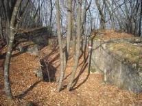
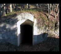
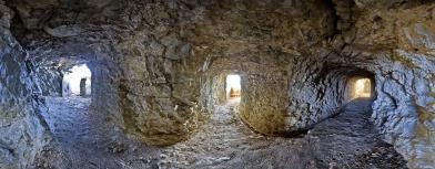
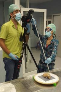
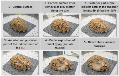
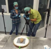
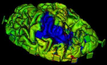
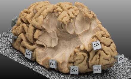
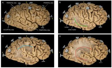
3 WHERE DO WE USE POINT CLOUDS? 3D mapping of WWI fortifications: underground tunnels and under-forest trenches, classification of trench structures and gallery components (enrances, riflemen emplacements, barracks, etc, WHERE DO WE USE POINT CLOUDS? Brain anatomy with photogrammetric point clouds at 0.05 mm resolution to (i) study the white matter for an exhaustive understanding of the brain diseases and (ii) identify axons in the white matter responsible to transport information across the brain [Nocerino, E., Menna, F., Remondino, F., Sarubbo, S., De Benedictis, A., Chioffi, F., Petralia, V., Barbareschi, M., Olivetti, E., Avesani, P., 2017: Application of photogrammetry to brain anatomy. ISPRS Int. Archives of PRS&SIS, XLII-2-W4, pp ] 3
![Object / Scene Complexity [points/object] 3/13/2018 TECHNIQUES FOR POINT CLOUD GENERATION 10 Mil 1 Mil 100 000 Close-range photogrammetry and UAV terrestrial laser scanners Aerial photogrammetry and](/docs-images/80/80967010/images/4-1.jpg "Satellite 3D Remote Sensing 10 000 1 000 100 10 Tactile / CMM Hand Topography GNSS 1 measurements 0.")
4 Object / Scene Complexity [points/object] 3/13/2018 TECHNIQUES FOR POINT CLOUD GENERATION 10 Mil 1 Mil Close-range photogrammetry and UAV terrestrial laser scanners Aerial photogrammetry and Satellite 3D Remote Sensing Tactile / CMM Hand Topography GNSS 1 measurements 0.1 m 1 m 10 m 100 m 1 km 10 km 100 km 1000 km Object / Scene Size 7 TECHNIQUES: IMAGING VS RANGING From 2000 there was a growing in popularity of /TLS sensors for the production of dense point clouds and photogrammetry could not efficiently deliver similar results Many researchers shifted their research interests to /TLS, resulting in a decline of new advancements / developments of new photogrammetric methods /TLS became the dominant technology for 3D recording and modelling, replacing photogrammetry in many application areas The bottleneck of photogrammetry was represented by massive manual data processing, high technical skills required, long processing time, etc. Over the past 10 years, improvements in hardware and software (primarily pushed from the Computer Vision community), have improved image-based tools and algorithms to the point that nowadays photogrammetry and /TLS can deliver comparable geometrical 3D results 8 4
 3D information To be derived direct Scale absent (to be provided) Implicit (1:1) Redundancy Multi-ray / Multi-view Single measure / Laser Scanning 2000 s with first commercial")
5 9 PHOTOGRAMMETRY Origin born ca 1850 s born ca 1960 s Maturity Measurement principle Spectrum / Radiometry 60 s-70 s (BBA); 90 s digital sensors; automated methods / SfM / DIM Triangulation Multispectral (VIS-NIR) 3D information To be derived direct Scale absent (to be provided) Implicit (1:1) Redundancy Multi-ray / Multi-view Single measure / Laser Scanning 2000 s with first commercial TLS and /ALS solutions TOF (long-range) and triangulation (short-range) laser wavelength, rarely multispectral Dependency Light, geometry, texture Distance, material, object reflectance Statistics/ Quality parameters For each 3D TECHNIQUES: IMAGING VS RANGING Point density pts/sqm 1-50 pts/sqm Generally one value for the entire cloud Precision/Accuracy XY most accurate than Z (depth) Z (depth) most accurate than XY Target detection Top-most surface (DSM) Multiple targets per pulse (DTM/DSM) TECHNIQUES: IMAGING VS RANGING Photogrammetry passive method (passive sensors) image-based method Scanning active method (active sensors) range-based method Image data acquisition Image pre-processing ACQUISITION Range data acquisition (dense 3D point cloud) Calibration and orientation PROCESSING Editing and alignment Dense 3D point cloud generation Surface generation, feature extraction and texture mapping STRUCTURING Surface generation, feature extraction and texture mapping Visualization, GIS products, Visualization, GIS products, VISUALIZATION replicas, inspection, virtual replicas, inspection, virtual 1:8 restoration, etc. restoration, etc. 1:
 DSLR cameras Panoramic cameras Single frame + Multi-view")


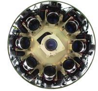
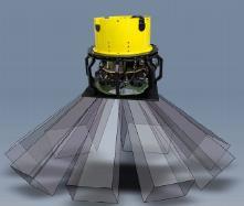
6 POINT CLOUD ACQUISITION - SENSORS AERIAL TERRESTRIAL PASSIVE HYBRID ACTIVE Single frame cameras Multi-view cameras (oblique) DSLR cameras Panoramic cameras Single frame + Multi-view + Mobile Mapping systems Hand-held / backpack system RGB-D sensors Traditional linear Airborne Laser Scanning SPL/Geiger-mode Airborne Laser Scanning TOF laser scanner (long-range) Triangulation laser scanners (short-range) Structured light systems (shortrange) 11 POINT CLOUD ACQUISITION - SENSORS AERIAL TERRESTRIAL PASSIVE HYBRID ACTIVE Single frame cameras Multi-view cameras (oblique) DSLR cameras Panoramic cameras Single frame + Multi-view + Mobile Mapping systems Hand-held / backpack system RGB-D sensors Traditional linear Airborne Laser Scanning SPL/Geiger-mode Airborne Laser Scanning TOF laser scanner (long-range) Triangulation laser scanners (short-range) Structured light systems (shortrange) Midas Octoblique 12 Vexcel Ultracam Osprey 6
 Single frame + Multi-view +")

 Triangulation laser scanners (short-range) Structured light")
 Leica BackPack Pegasus")
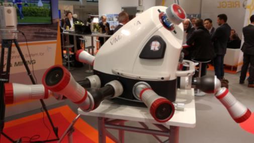

7 POINT CLOUD ACQUISITION - SENSORS PASSIVE HYBRID ACTIVE AERIAL Single frame cameras Multi-view cameras (oblique) Single frame + Multi-view + Traditional linear Airborne Laser Scanning SPL/Geiger-mode Airborne Laser Scanning TERRESTRIAL DSLR cameras Panoramic cameras Mobile Mapping systems Hand-held / backpack system RGB-D sensors TOF laser scanner (long-range) Triangulation laser scanners (short-range) Structured light systems (shortrange) Nadir camera Leica CityMapper 13 Oblique cameras Leica CountryMapper POINT CLOUD ACQUISITION - SENSORS PASSIVE HYBRID ACTIVE AERIAL Single frame cameras Multi-view cameras (oblique) Single frame + Multi-view + Traditional linear Airborne Laser Scanning SPL/Geiger-mode Airborne Laser Scanning TERRESTRIAL DSLR cameras Panoramic cameras Mobile Mapping systems Hand-held / backpack system RGB-D sensors TOF laser scanner (long-range) Triangulation laser scanners (short-range) Structured light systems (shortrange) Leica BackPack Pegasus Trimble Timms Siteco Road-Scanner Riegl VMX-2HA 14 7

 from 10 to 100 pts/sqm, up to 6 mil.")

8 POINT CLOUD ACQUISITION - SENSORS AERIAL TERRESTRIAL PASSIVE HYBRID ACTIVE Single frame cameras Multi-view cameras (oblique) DSLR cameras Panoramic cameras Single frame + Multi-view + Mobile Mapping systems Hand-held / backpack system RGB-D sensors Traditional linear Airborne Laser Scanning SPL/Geiger-mode Airborne Laser Scanning TOF laser scanner (long-range) Triangulation laser scanners (short-range) Structured light systems (shortrange) Laser output split in n x m array of laser beamlets (SigmaSpace / Leica: 10 x 10; Harris: 32 x 128) from 10 to 100 pts/sqm, up to 6 mil. pts/sec 5 times more effective than traditional Range of operation: m 200 knot speed DENSE IMAGE MATCHING (DIM) POINT CLOUD ACQUISITION IMAGE ALGORITHMS 1950 s: Analogue image matching and stereoplotter 1980 s: Least squares matching & Multi-photo matching 1990 s: Digital stereo processing systems Today: From feature matching to dense stereo 1960 s: First digital cross-correlation 2000 s: Close range photogrammetry, convergent images, MVS, SGM 8
 Apply local / global algorithms (aggregation) - iterative updating Apply optimization algorithms - energy (cost) formulation, Markov Random Fields, graph algorithms, least squares, etc.")
, pp.")
9 POINT CLOUD ACQUISITION IMAGE ALGORITHMS Image rectification / epipolar Select a matching criteria (what and how do I match?) Use some assumptions (e.g. constant depth/disparity, continuity constraint, etc.) Apply local / global algorithms (aggregation) - iterative updating Apply optimization algorithms - energy (cost) formulation, Markov Random Fields, graph algorithms, least squares, etc. Consider multi-view stereo (MVS) Efficiency thru dynamic programming, GPU and FPGA implementations [Remondino, F., Spera, M.G., Nocerino, E., Menna, F., Nex, F., 2014: State of the art in high density image matching. The Photogrammetric Record, Vol. 29(146), pp ] 17 GEOMETRY and ATTRIBUTES not only geometry data (3D coordinates), but also attributes, e.g. PHOTOGRAMMETRY RGB reconstruction uncentainty redundancy intersection angles classes (post-processing) normals (post-processing) intensity returns time strip classes (post-processing) normals 18 9
 precision of 3D points (mean 0.")


![675-683] POINT CLOUD STRUCTURING Normally point clouds are unstructured 3D data (with few](/docs-images/80/80967010/images/10-3.jpg "exceptions) Structuring can be seen as generation of an organized dataset (e.g. 2.")
 Bergamo (Italy) - AVT flight with Vexcel Osprey and dense point cloud @ 10 cm resolution")

10 GEOMETRY and ATTRIBUTES Photogrammetry attributes from bundle adjustment and dense image matching redundancy of 3D points (3-65) precision of 3D points (mean 0.06 mm) intersection angles (20-90 deg) [Menna, F., Nocerino, E., Remondino, F., Dellepiane, M., Callieri, M. and Scopigno, R., 2016: 3D Digitization of an Heritage Masterpiece - a Critical Analysis on Quality Assessment. ISPRS Int. Archives of PRS&SIS, Vol. XLI-B5, pp ] POINT CLOUD STRUCTURING Normally point clouds are unstructured 3D data (with few exceptions) Structuring can be seen as generation of an organized dataset (e.g. 2.5D grid DSM) generation of structured 3D data (e.g. mesh model, 3D building models, etc.) Bergamo (Italy) - AVT flight with Vexcel Osprey and dense point 10 cm resolution Bergamo (Italy) - AVT flight with Vexcel Osprey and 3D semantic modeling of building based on primitive fitting [Toschi, I., Ramos, M.M., Nocerino, E., Menna, F., Remondino, F., Moe, K., Poli, D., Legat, K., Fassi, F., 2017: Oblique photogrammetry supporting 3D urban reconstruction of complex scenarios. ISPRS Int. Archives of PRS&SISI, Vol. XLII-1- W1, pp ] 10
 generation of structured 3D data (e.")
 Huge and unique mesh/polygonal model vs 3D modeling of each single building (LOD2) with parametric shapes")
 3D dense point cloud and classification results using")
11 POINT CLOUD STRUCTURING Normally point clouds are unstructured 3D data (with few exceptions) Structuring can be seen as generation of an organized dataset (e.g. 2.5D grid DSM) generation of structured 3D data (e.g. mesh model, 3D building models, etc.) Huge and unique mesh/polygonal model vs 3D modeling of each single building (LOD2) with parametric shapes fitted on the DSM Trento (Italy) - AVT flight with Vexcel 10 cm GSD POINT CLOUD STRUCTURING Normally point clouds are unstructured 3D data (with few exceptions) Structuring can be seen as generation of an organized dataset (e.g. 2.5D grid DSM) generation of structured 3D data (e.g. mesh model, 3D building models, etc.) generation of classified / segmented point clouds Dortmund (ISPRS benchmark) 3D dense point cloud and classification results using deep learning (supervised) methods 11

12 CONCLUSIONS & OPEN ISSUES Technology is super rapidly democratizing and point clouds are nowadays everywhere for many applications and at disposal of many end-users Point clouds are the real surveying product and have more added value than derived products as they keep details and they are not interpolated From a business point of view, probably, the money maker is not anymore the data acquisition part but the added value we can give to point clouds for domain-specific applications How do we enrich point clouds with attributes useful to end-users? Which are the attribute that should be (always) linked to geometry? How do we reliably and efficiently extract semantic information to support domain-experts? How do we store, visualize and transmit enriched point cloud data to non-specialist users? How do we provide analytics for multi-temporal point clouds? 12
STATE-OF-THE-ART in DENSE IMAGE MATCHING
 STATE-OF-THE-ART in DENSE IMAGE MATCHING Fabio REMONDINO 3D Optical Metrology (3DOM) Bruno Kessler Foundation (FBK) Trento, Italy Email: remondino@fbk.eu http://3dom.fbk.eu Bruno Kessler Foundation (FBK)
USE OF VERTICAL AERIAL IMAGES FOR SEMI-OBLIQUE MAPPING
 USE OF VERTICAL AERIAL IMAGES FOR SEMI-OBLIQUE MAPPING D. Poli a, K. Moe a, K. Legat b, I. Toschi b, F. Lago b, F. Remondino b a Terra Messflug GmbH, Eichenweg 42, 6460 Imst, Austria (k.moe, d.poli)@terra-messflug.at
Segmentation of 3D Photogrammetric Point Cloud for 3D Building Modeling
 Segmentation of 3D Photogrammetric Point Cloud for 3D Building Modeling EMRE ÖZDEMİR 1,2, Fabio Remondino 1 1 3D Optical Metrology unit Bruno Kessler Foundation (FBK) Trento, Italy https://3dom.fbk.eu
OBLIQUE AERIAL IMAGERY FOR NMA SOME BEST PRACTICES
 OBLIQUE AERIAL IMAGERY FOR NMA SOME BEST PRACTICES F. Remondino 1, I. Toschi 1, M. Gerke 2, F. Nex 2, D. Holland 3, A. McGill 4, J. Talaya Lopez 5, A. Magarinos 5 1 3D Optical Metrology (3DOM) unit, Bruno
STATUS OF AIRBORNE OBLIQUE IMAGING EUROSDR COMMISSION I PROJECT OBLIQUE IMAGERY. Markus Gerke May 15, 2014
 STATUS OF AIRBORNE OBLIQUE IMAGING EUROSDR COMMISSION I PROJECT OBLIQUE IMAGERY Markus Gerke May 15, 2014 THE FIRST AIRBORNE PHOTOS WERE OBLIQUE First recorded aerial photograph in the US (Boston), by
Oblique aerial imagery in the praxis: applications and challenges
 ISPRS / EuroSDR Workshop on Oblique aerial cameras sensors and data processing Barcelona, 10 October 2017 Oblique aerial imagery in the praxis: applications and challenges Daniela Poli, Kjersti Moe, Klaus
OBLIQUE AERIAL IMAGES: POTENTIALITIES, APPLICATIONS AND BEST PRACTICES FRANCESCO NEX
 OBLIQUE AERIAL IMAGES: POTENTIALITIES, APPLICATIONS AND BEST PRACTICES FRANCESCO NEX f.nex@utwente.nl The history of oblique imagery First recorded aerial photo in the US (1860) by J.W. Black and S. King
OBLIQUE AERIAL IMAGERY A REVIEW
 OBLIQUE AERIAL IMAGERY A REVIEW FABIO REMONDINO 3D Optical Metrology unit Bruno Kessler Foundation (FKB) Trento, Italy http://3dom.fbk.eu Email: remondino@fbk.eu MARKUS GERKE EOS dept. ITC / Univ. Twente,
EVOLUTION OF POINT CLOUD
 Figure 1: Left and right images of a stereo pair and the disparity map (right) showing the differences of each pixel in the right and left image. (source: https://stackoverflow.com/questions/17607312/difference-between-disparity-map-and-disparity-image-in-stereo-matching)
GABRIELE GUIDI, PHD POLITECNICO DI MILANO, ITALY VISITING SCHOLAR AT INDIANA UNIVERSITY NOV OCT D IMAGE FUSION
 GABRIELE GUIDI, PHD POLITECNICO DI MILANO, ITALY VISITING SCHOLAR AT INDIANA UNIVERSITY NOV 2017 - OCT 2018 3D IMAGE FUSION 3D IMAGE FUSION WHAT A 3D IMAGE IS? A cloud of 3D points collected from a 3D
Intelligent photogrammetry. Agisoft
 Intelligent photogrammetry Agisoft Agisoft Metashape is a cutting edge software solution, with its engine core driving photogrammetry to its ultimate limits, while the whole system is designed to deliver
THE ISPRS/EUROSDR BENCHMARK ON MULTI-PLATFORM PHOTOGRAMMETRY: RESULTS AND LESSON LEARNT FRANCESCO NEX AND MARKUS GERKE
 THE ISPRS/EUROSDR BENCHMARK ON MULTI-PLATFORM PHOTOGRAMMETRY: RESULTS AND LESSON LEARNT FRANCESCO NEX AND MARKUS GERKE Overview Summary of the results Statistics Data release What s next? ISPRS / EuroSDR
Vexcel Imaging Ve V x e c x el e I l maging I G maging mbh www. wwwv. e v x e c x e c l e -limaging. - c imaging. om c
 Vexcel Imaging History 2016 MBO: becomes a privately owned company again 2006 Vexcel Imaging acquired by Microsoft Corp., Redmond/USA 2003 1992 1985 Merger of Vexcel Corp. & Vexcel Imaging 1 st Digital
Automatic image network design leading to optimal image-based 3D models
 Automatic image network design leading to optimal image-based 3D models Enabling laymen to capture high quality 3D models of Cultural Heritage Bashar Alsadik & Markus Gerke, ITC, University of Twente,
Presented at the FIG Congress 2018, May 6-11, 2018 in Istanbul, Turkey
 Presented at the FIG Congress 2018, May 6-11, 2018 in Istanbul, Turkey Evangelos MALTEZOS, Charalabos IOANNIDIS, Anastasios DOULAMIS and Nikolaos DOULAMIS Laboratory of Photogrammetry, School of Rural
Multi-ray photogrammetry: A rich dataset for the extraction of roof geometry for 3D reconstruction
 Multi-ray photogrammetry: A rich dataset for the extraction of roof geometry for 3D reconstruction Andrew McClune, Pauline Miller, Jon Mills Newcastle University David Holland Ordnance Survey Background
The raycloud A Vision Beyond the Point Cloud
 The raycloud A Vision Beyond the Point Cloud Christoph STRECHA, Switzerland Key words: Photogrammetry, Aerial triangulation, Multi-view stereo, 3D vectorisation, Bundle Block Adjustment SUMMARY Measuring
ENY-C2005 Geoinformation in Environmental Modeling Lecture 4b: Laser scanning
 1 ENY-C2005 Geoinformation in Environmental Modeling Lecture 4b: Laser scanning Petri Rönnholm Aalto University 2 Learning objectives To recognize applications of laser scanning To understand principles
HIGH DENSITY AERIAL IMAGE MATCHING: STATE-OF-THE-ART AND FUTURE PROSPECTS
 HIGH DENSITY AERIAL IMAGE MATCHING: STATE-OF-THE-ART AND FUTURE PROSPECTS N. Haala a *, S. Cavegn a, b a Institute for Photogrammetry, University of Stuttgart, Germany - norbert.haala@ifp.uni-stuttgart.de
ISPRS Benchmark for Multi-Platform Photogrammetry
 ISPRS Benchmark for Multi-Platform Photogrammetry Francesco Nex (FBK) Markus Gerke (University of Twente/ITC) Fabio Remondino (FBK) Heinz-Jürgen Przybilla (HS Bochum) Manfred Bäumker (HS Bochum) Alexander
Automated Processing for 3D Mosaic Generation, a Change of Paradigm
 Automated Processing for 3D Mosaic Generation, a Change of Paradigm Frank BIGNONE, Japan Key Words: 3D Urban Model, Street Imagery, Oblique imagery, Mobile Mapping System, Parallel processing, Digital
EVALUATION OF WORLDVIEW-1 STEREO SCENES AND RELATED 3D PRODUCTS
 EVALUATION OF WORLDVIEW-1 STEREO SCENES AND RELATED 3D PRODUCTS Daniela POLI, Kirsten WOLFF, Armin GRUEN Swiss Federal Institute of Technology Institute of Geodesy and Photogrammetry Wolfgang-Pauli-Strasse
THE ETRUSCANS IN 3D: FROM SPACE TO UNDERGROUND
 THE ETRUSCANS IN 3D: FROM SPACE TO UNDERGROUND Fabio Remondino 1, Alessandro Rizzi 1, Belen Jimenez 1, Giorgio Agugiaro 1, Giorgio Baratti 1, Raffaele De Amicis 2 (1) 3D Optical Metrology (3DOM) Bruno
1. Introduction. A CASE STUDY Dense Image Matching Using Oblique Imagery Towards All-in- One Photogrammetry
 Submitted to GIM International FEATURE A CASE STUDY Dense Image Matching Using Oblique Imagery Towards All-in- One Photogrammetry Dieter Fritsch 1, Jens Kremer 2, Albrecht Grimm 2, Mathias Rothermel 1
Multiray Photogrammetry and Dense Image. Photogrammetric Week Matching. Dense Image Matching - Application of SGM
 Norbert Haala Institut für Photogrammetrie Multiray Photogrammetry and Dense Image Photogrammetric Week 2011 Matching Dense Image Matching - Application of SGM p q d Base image Match image Parallax image
PERFORMANCE ANALYSIS OF FAST AT FOR CORRIDOR AERIAL MAPPING
 PERFORMANCE ANALYSIS OF FAST AT FOR CORRIDOR AERIAL MAPPING M. Blázquez, I. Colomina Institute of Geomatics, Av. Carl Friedrich Gauss 11, Parc Mediterrani de la Tecnologia, Castelldefels, Spain marta.blazquez@ideg.es
From Multi-sensor Data to 3D Reconstruction of Earth Surface: Innovative, Powerful Methods for Geoscience and Other Applications
 From Multi-sensor Data to 3D Reconstruction of Earth Surface: Innovative, Powerful Methods for Geoscience and Other Applications Bea Csatho, Toni Schenk*, Taehun Yoon* and Michael Sheridan, Department
REGISTRATION OF AIRBORNE LASER DATA TO SURFACES GENERATED BY PHOTOGRAMMETRIC MEANS. Y. Postolov, A. Krupnik, K. McIntosh
 REGISTRATION OF AIRBORNE LASER DATA TO SURFACES GENERATED BY PHOTOGRAMMETRIC MEANS Y. Postolov, A. Krupnik, K. McIntosh Department of Civil Engineering, Technion Israel Institute of Technology, Haifa,
Bringing Singapore to life in 3D
 Bringing Singapore to life in 3D Dr Victor Khoo, Deputy Director Singapore Land Authority Bringing Singapore to life in 3D ESRI Singapore UC 2016 Dr. Victor Khoo Singapore Land Authority SLA 2016 RESTRICTED
PhotoScan. Fully automated professional photogrammetric kit
 PhotoScan Fully automated professional photogrammetric kit Agisoft PhotoScan is a stand-alone photogrammetric software solution for automatic generation of dense point clouds, textured polygonal models,
Introduction to photogrammetry (with an underwater flavor)
") Introduction to photogrammetry (with an underwater flavor) NAS - UCY HFF Field school, Cyprus, 2016 Dimitrios Skarlatos, Assistant Professor, Cyprus University of Technology Photogrammetric vision Lab
Introduction to photogrammetry (with an underwater flavor) NAS - UCY HFF Field school, Cyprus, 2016 Dimitrios Skarlatos, Assistant Professor, Cyprus University of Technology Photogrammetric vision Lab
Mayden VP of Business Development Surdex Corporation
 Making Sense of Sensors Randy Mayden, Mayden VP of Business Development Surdex Corporation randym@surdex.com EARLYAERIAL PHOTOGRAPHY 2 FIRSTAERIAL CAMERA 3 AERIAL CAMERA SYSTEM DEVELOPMENT Aerial Camera
Oblique aerial photography viewer and monoplotting tool for building façade inspection and disaster assessment
 Oblique aerial photography viewer and monoplotting tool for building façade inspection and disaster assessment Arnadi Murtiyoso Department of Topography INSA Strasbourg, France arnadi.murtiyoso@insa-strasbourg.fr
Trimble GeoSpatial Products
 Expanding Solutions for Photogrammetric and Remote Sensing Professionals 55 th Photogrammetric Week in Stuttgart September 7 th 2015 Tobias Heuchel, Trimble Stuttgart, Germany Trimble GeoSpatial Products
High Definition Modeling of Calw, Badstrasse and its Google Earth Integration
 Master Thesis Yuanting LI High Definition Modeling of Calw, Badstrasse and its Google Earth Integration Duration of the Thesis: 6 months Completion: July, 2014 Supervisors: Prof.Dr.-Ing.Dieter Fritsch
PhotoScan. Fully automated professional photogrammetric kit
 PhotoScan Fully automated professional photogrammetric kit Agisoft PhotoScan is a stand-alone photogrammetric software solution for automatic generation of dense point clouds, textured polygonal models,
CE 59700: LASER SCANNING
 Digital Photogrammetry Research Group Lyles School of Civil Engineering Purdue University, USA Webpage: http://purdue.edu/ce/ Email: ahabib@purdue.edu CE 59700: LASER SCANNING 1 Contact Information Instructor:
Introduction. Acute3D S.A.S. WTC Valbonne Sophia Antipolis. 120 route des Macarons.
 Introduction This benchmark compares the performances of the three main photo-based 3Dmodeling software. Five projects related to different kind of applications were led on the same machine and this document
NATIONWIDE POINT CLOUDS AND 3D GEO- INFORMATION: CREATION AND MAINTENANCE GEORGE VOSSELMAN
 NATIONWIDE POINT CLOUDS AND 3D GEO- INFORMATION: CREATION AND MAINTENANCE GEORGE VOSSELMAN OVERVIEW National point clouds Airborne laser scanning in the Netherlands Quality control Developments in lidar
GENERATING BUILDING OUTLINES FROM TERRESTRIAL LASER SCANNING
 GENERATING BUILDING OUTLINES FROM TERRESTRIAL LASER SCANNING Shi Pu International Institute for Geo-information Science and Earth Observation (ITC), Hengelosestraat 99, P.O. Box 6, 7500 AA Enschede, The
Automated Extraction of Buildings from Aerial LiDAR Point Cloud and Digital Imaging Datasets for 3D Cadastre - Preliminary Results
 Automated Extraction of Buildings from Aerial LiDAR Point Cloud and Digital Imaging Datasets for 3D Pankaj Kumar 1*, Alias Abdul Rahman 1 and Gurcan Buyuksalih 2 ¹Department of Geoinformation Universiti
COMPARISON OF LASER SCANNING, PHOTOGRAMMETRY AND SfM-MVS PIPELINE APPLIED IN STRUCTURES AND ARTIFICIAL SURFACES
 COMPARISON OF LASER SCANNING, PHOTOGRAMMETRY AND SfM-MVS PIPELINE APPLIED IN STRUCTURES AND ARTIFICIAL SURFACES 2012 ISPRS Melbourne, Com III/4, S.Kiparissi Cyprus University of Technology 1 / 28 Structure
A 3D scanning primer. Marco Callieri Matteo Dellepiane Visual Computig Lab ISTI-CNR
 A 3D scanning primer Marco Callieri Matteo Dellepiane Visual Computig Lab ISTI-CNR 0 Digital Models...... of real objects. You have seen lots of them. Digital representation of the surface of an object
Capturing Reality with Point Clouds: Applications, Challenges and Solutions
 Capturing Reality with Point Clouds: Applications, Challenges and Solutions Rico Richter 1 st February 2017 Oracle Spatial Summit at BIWA 2017 Hasso Plattner Institute Point Cloud Analytics and Visualization
Unwrapping of Urban Surface Models
 Unwrapping of Urban Surface Models Generation of virtual city models using laser altimetry and 2D GIS Abstract In this paper we present an approach for the geometric reconstruction of urban areas. It is
XXV FIG International Congress KUALA LUMPUR Highly Detailed 3D Modelling of Mayan Cultural Heritage using an UAV
 XXV FIG International Congress KUALA LUMPUR 2014 Highly Detailed 3D Modelling of Mayan Cultural Heritage using an UAV Cornelis Stal, Britt Lonneville, Timothy Nuttens, Philippe De Maeyer, Alain De Wulf
RealWorld RealCity RealTerrain Airborne Reality Capture The Integral World of Leica Airborne Solutions
 RealWorld RealCity RealTerrain Airborne Reality Capture The Integral World of Leica Airborne Solutions Photogrammetric Week, September 11, 2017 Dr. Hartmut Rosengarten, Director Airborne Solutions EMEA,
AIRBORNE GEIGER MODE LIDAR - LATEST ADVANCEMENTS IN REMOTE SENSING APPLICATIONS RANDY RHOADS
 Place image here (10 x 3.5 ) AIRBORNE GEIGER MODE LIDAR - LATEST ADVANCEMENTS IN REMOTE SENSING APPLICATIONS RANDY RHOADS Geospatial Industry Manager HARRIS.COM #HARRISCORP Harris Company Information SECURITY
3D MODELING OF CLOSE-RANGE OBJECTS: PHOTOGRAMMETRY OR LASER SCANNING?
 3D MODELING OF CLOSE-RANGE OBJECTS: PHOTOGRAMMETRY OR LASER SCANNING? F. Remondino 1 A. Guarnieri 2 A. Vettore 2 1 Institute of Geodesy and Photogrammetry ETH Hönggerberg - Zurich, Switzerland e-mail:
Overview of the Trimble TX5 Laser Scanner
 Overview of the Trimble TX5 Laser Scanner Trimble TX5 Revolutionary and versatile scanning solution Compact / Lightweight Efficient Economical Ease of Use Small and Compact Smallest and most compact 3D
LASERDATA LIS build your own bundle! LIS Pro 3D LIS 3.0 NEW! BETA AVAILABLE! LIS Road Modeller. LIS Orientation. LIS Geology.
 LIS 3.0...build your own bundle! NEW! LIS Geology LIS Terrain Analysis LIS Forestry LIS Orientation BETA AVAILABLE! LIS Road Modeller LIS Editor LIS City Modeller colors visualization I / O tools arithmetic
3D recording of archaeological excavation
 5 th International Conference Remote Sensing in Archaeology The Age of Sensing 13-15 October 2014 - Duke University 3D recording of archaeological excavation Stefano Campana UNIVERSITY of CAMBRIDGE Faculty
Digital Preservation of the Aurelius Church and the Hirsau Museum Complex by Means of HDS and Photogrammetric Texture Mapping
 Master Thesis Ruxandra MOROSAN Ruxandra MOROSAN Digital Preservation of the Aurelius Church and the Hirsau Museum Complex by Means of HDS and Photogrammetric Texture Mapping Duration of the Thesis: 6 months
The main problem of photogrammetry
 Structured Light Structured Light The main problem of photogrammetry to recover shape from multiple views of a scene, we need to find correspondences between the images the matching/correspondence problem
LiForest Software White paper. TRGS, 3070 M St., Merced, 93610, Phone , LiForest
 0 LiForest LiForest is a platform to manipulate large LiDAR point clouds and extract useful information specifically for forest applications. It integrates a variety of advanced LiDAR processing algorithms
REPORT OF THE SCIENTIFIC INITIATIVE
 Bruno Kessler Foundation (FBK) 3D Optical Metrology Unit (3DOM) Via Sommarive 18, Trento, Italy http://3dom.fbk.eu ISPRS BENCHMARK FOR MULTI-PLATFORM PHOTOGRAMMETRY REPORT OF THE SCIENTIFIC INITIATIVE
TAKING LIDAR SUBSEA. Adam Lowry, Nov 2016
 TAKING LIDAR SUBSEA Adam Lowry, Nov 2016 3D AT DEPTH Based in the technology hub of Boulder, Colorado, 3D at Depth is dedicated to the development of underwater laser measurement sensors and software Patented
a Geo-Odyssey of UAS LiDAR Mapping Henno Morkel UAS Segment Specialist DroneCon 17 May 2018
 a Geo-Odyssey of UAS LiDAR Mapping Henno Morkel UAS Segment Specialist DroneCon 17 May 2018 Abbreviations UAS Unmanned Aerial Systems LiDAR Light Detection and Ranging UAV Unmanned Aerial Vehicle RTK Real-time
Sasanka Madawalagama Geoinformatics Center Asian Institute of Technology Thailand
 Sasanka Madawalagama Geoinformatics Center Asian Institute of Technology Thailand This learning material was not prepared by ADB. The views expressed in this document are the views of the author/s and
APPLICATION AND ACCURACY EVALUATION OF LEICA ADS40 FOR LARGE SCALE MAPPING
 APPLICATION AND ACCURACY EVALUATION OF LEICA ADS40 FOR LARGE SCALE MAPPING WenYuan Hu a, GengYin Yang b, Hui Yuan c,* a, b ShanXi Provincial Survey and Mapping Bureau, China - sxgcchy@public.ty.sx.cn c
Photo based Terrain Data Acquisition & 3D Modeling
 Photo based Terrain Data Acquisition & 3D Modeling June 7, 2013 Howard Hahn Kansas State University Partial funding by: KSU Office of Research and Sponsored Programs Introduction: Need Application 1 Monitoring
Comparing Aerial Photogrammetry and 3D Laser Scanning Methods for Creating 3D Models of Complex Objects
 Comparing Aerial Photogrammetry and 3D Laser Scanning Methods for Creating 3D Models of Complex Objects A Bentley Systems White Paper Cyril Novel Senior Software Engineer, Bentley Systems Renaud Keriven
THREE-DIMENSIONAL MAPPING OF AN ANCIENT CAVE PAINTINGS USING CLOSE-RANGE PHOTOGRAMMETRY AND TERRESTRIAL LASER SCANNING TECHNOLOGIES
 THREE-DIMENSIONAL MAPPING OF AN ANCIENT CAVE PAINTINGS USING CLOSE-RANGE PHOTOGRAMMETRY AND TERRESTRIAL LASER SCANNING TECHNOLOGIES Z. Majid a, M. F. M. Ariff a, K. M. Idris a, A. R. Yusoff a, K.M. Idris
The Processing of Laser Scan Data for the Analysis of Historic Structures in Ireland
 The 7th International Symposium on Virtual Reality, Archaeology and Cultural Heritage VAST (2006) M. Ioannides, D. Arnold, F. Niccolucci, K. Mania (Editors) The Processing of Laser Scan Data for the Analysis
Overview. 1. Aerial LiDAR in Wisconsin (20 minutes) 2. Demonstration of data in CAD (30 minutes) 3. High Density LiDAR (20 minutes)
 2. Demonstration of data in CAD (30 minutes) 3. High Density LiDAR (20 minutes)") Overview 1. Aerial LiDAR in Wisconsin (20 minutes) 2. Demonstration of data in CAD (30 minutes) 3. High Density LiDAR (20 minutes) 4. Aerial lidar technology advancements (15 minutes) 5. Q & A 1. Aerial
Overview 1. Aerial LiDAR in Wisconsin (20 minutes) 2. Demonstration of data in CAD (30 minutes) 3. High Density LiDAR (20 minutes) 4. Aerial lidar technology advancements (15 minutes) 5. Q & A 1. Aerial
DETERMINATION OF CORRESPONDING TRUNKS IN A PAIR OF TERRESTRIAL IMAGES AND AIRBORNE LASER SCANNER DATA
 The Photogrammetric Journal of Finland, 20 (1), 2006 Received 31.7.2006, Accepted 13.11.2006 DETERMINATION OF CORRESPONDING TRUNKS IN A PAIR OF TERRESTRIAL IMAGES AND AIRBORNE LASER SCANNER DATA Olli Jokinen,
DENSE 3D POINT CLOUD GENERATION FROM UAV IMAGES FROM IMAGE MATCHING AND GLOBAL OPTIMAZATION
 DENSE 3D POINT CLOUD GENERATION FROM UAV IMAGES FROM IMAGE MATCHING AND GLOBAL OPTIMAZATION S. Rhee a, T. Kim b * a 3DLabs Co. Ltd., 100 Inharo, Namgu, Incheon, Korea ahmkun@3dlabs.co.kr b Dept. of Geoinformatic
N.J.P.L.S. An Introduction to LiDAR Concepts and Applications
 N.J.P.L.S. An Introduction to LiDAR Concepts and Applications Presentation Outline LIDAR Data Capture Advantages of Lidar Technology Basics Intensity and Multiple Returns Lidar Accuracy Airborne Laser
Hardware 3D Mapping Systems
 Hardware 3D Mapping Systems About Us GreenValley International GreenValley International provides 3D mapping solutions that include mobile & aerial LiDAR acquisition hardware, post-processing software
Todd King, PLS, LEED AP Business Developer
 Todd King, PLS, LEED AP Business Developer TKing@McKimCreed.com 38 YEARS 378 EMPLOYEES ENR Top 500 Design Firm ENR Top 200 Environmental ENR Southeast Engineer Firms POB Geospatial Top 100 Top 50 Trenchless
Computer Vision. 3D acquisition
 è Computer 3D acquisition Acknowledgement Courtesy of Prof. Luc Van Gool 3D acquisition taxonomy s image cannot currently be displayed. 3D acquisition methods Thi passive active uni-directional multi-directional
L2 Data Acquisition. Mechanical measurement (CMM) Structured light Range images Shape from shading Other methods
 Structured light Range images Shape from shading Other methods") L2 Data Acquisition Mechanical measurement (CMM) Structured light Range images Shape from shading Other methods 1 Coordinate Measurement Machine Touch based Slow Sparse Data Complex planning Accurate 2
L2 Data Acquisition Mechanical measurement (CMM) Structured light Range images Shape from shading Other methods 1 Coordinate Measurement Machine Touch based Slow Sparse Data Complex planning Accurate 2
Integrated Multi-Source LiDAR and Imagery
 Figure 1: AirDaC aerial scanning system Integrated Multi-Source LiDAR and Imagery The derived benefits of LiDAR scanning in the fields of engineering, surveying, and planning are well documented. It has
The Topographic Data Deluge Collecting and Maintaining Data in a 21 st Century Mapping Agency
 The Topographic Data Deluge Collecting and Maintaining Data in a 21 st Century Mapping Agency D. A. Holland a*, C. Pook a, D. Capstick a, A. Hemmings a a Ordnance Survey, Adanac Drive, Southampton SO16
INTEGRATION OF MOBILE LASER SCANNING DATA WITH UAV IMAGERY FOR VERY HIGH RESOLUTION 3D CITY MODELING
 INTEGRATION OF MOBILE LASER SCANNING DATA WITH UAV IMAGERY FOR VERY HIGH RESOLUTION 3D CITY MODELING Xianfeng Huang 1,2 Armin Gruen 1, Rongjun Qin 1 Tangwu Du 1, Wei Fang 1 1 Singapore-ETH Center, Future
Airborne LiDAR Data Acquisition for Forestry Applications. Mischa Hey WSI (Corvallis, OR)
") Airborne LiDAR Data Acquisition for Forestry Applications Mischa Hey WSI (Corvallis, OR) WSI Services Corvallis, OR Airborne Mapping: Light Detection and Ranging (LiDAR) Thermal Infrared Imagery 4-Band
Airborne LiDAR Data Acquisition for Forestry Applications Mischa Hey WSI (Corvallis, OR) WSI Services Corvallis, OR Airborne Mapping: Light Detection and Ranging (LiDAR) Thermal Infrared Imagery 4-Band
Outline of Presentation. Introduction to Overwatch Geospatial Software Feature Analyst and LIDAR Analyst Software
 Outline of Presentation Automated Feature Extraction from Terrestrial and Airborne LIDAR Presented By: Stuart Blundell Overwatch Geospatial - VLS Ops Co-Author: David W. Opitz Overwatch Geospatial - VLS
2. POINT CLOUD DATA PROCESSING
 Point Cloud Generation from suas-mounted iphone Imagery: Performance Analysis A. D. Ladai, J. Miller Towill, Inc., 2300 Clayton Road, Suite 1200, Concord, CA 94520-2176, USA - (andras.ladai, jeffrey.miller)@towill.com
CO-REGISTERING AND NORMALIZING STEREO-BASED ELEVATION DATA TO SUPPORT BUILDING DETECTION IN VHR IMAGES
 CO-REGISTERING AND NORMALIZING STEREO-BASED ELEVATION DATA TO SUPPORT BUILDING DETECTION IN VHR IMAGES Alaeldin Suliman, Yun Zhang, Raid Al-Tahir Department of Geodesy and Geomatics Engineering, University
Image-based 3D Data Capture in Urban Scenarios
 Photogrammetric Week '15 Dieter Fritsch (Ed.) Wichmann/VDE Verlag, Belin & Offenbach, 2015 Haala, Rothermel 119 Image-based 3D Data Capture in Urban Scenarios Norbert Haala, Mathias Rothermel, Stuttgart
FAST REGISTRATION OF TERRESTRIAL LIDAR POINT CLOUD AND SEQUENCE IMAGES
 FAST REGISTRATION OF TERRESTRIAL LIDAR POINT CLOUD AND SEQUENCE IMAGES Jie Shao a, Wuming Zhang a, Yaqiao Zhu b, Aojie Shen a a State Key Laboratory of Remote Sensing Science, Institute of Remote Sensing
Advanced point cloud processing
 Advanced point cloud processing George Vosselman ITC Enschede, the Netherlands INTERNATIONAL INSTITUTE FOR GEO-INFORMATION SCIENCE AND EARTH OBSERVATION Laser scanning platforms Airborne systems mounted
Comparing Aerial Photogrammetry and 3D Laser Scanning Methods for Creating 3D Models of Complex Objects
 www.bentley.com Comparing Aerial Photogrammetry and 3D Laser Scanning Methods for Creating 3D Models of Complex Objects A Bentley White Paper Cyril Novel Senior Software Engineer, Bentley Systems Renaud
TLS Parameters, Workflows and Field Methods
 TLS Parameters, Workflows and Field Methods Marianne Okal, UNAVCO June 20 th, 2014 How a Lidar instrument works (Recap) Transmits laser signals and measures the reflected light to create 3D point clouds.
Leica ADS80 and Leica XPro - A total solution for photogrammetric mapping
 Leica ADS80 and Leica XPro - A total solution for photogrammetric mapping Ruedi Wagner, VP Imaging, Geospatial Solutions Division Phowo 2009 - Real Geospatial Solutions What else can I do with my sensor?
Light Detection and Ranging (LiDAR)
") Light Detection and Ranging (LiDAR) http://code.google.com/creative/radiohead/ Types of aerial sensors passive active 1 Active sensors for mapping terrain Radar transmits microwaves in pulses determines
Light Detection and Ranging (LiDAR) http://code.google.com/creative/radiohead/ Types of aerial sensors passive active 1 Active sensors for mapping terrain Radar transmits microwaves in pulses determines
DATA FUSION IN CULTURAL HERITAGE A REVIEW
 The International Archives of the Sciences, Volume XL-5/W7, 2015 DATA FUSION IN CULTURAL HERITAGE A REVIEW M. Magda Ramos, Fabio Remondino 3D Optical Metrology (3DOM) unit, Bruno Kessler Foundation (FBK),
Recent developments in laser scanning
 Recent developments in laser scanning Kourosh Khoshelham With contributions from: Sander Oude Elberink, Guorui Li, Xinwei Fang, Sudan Xu and Lucia Diaz Vilarino Why laser scanning? Laser scanning accurate
ROAD-SCANNER COMPACT APPLICATION FIELDS MAIN FEATURES
 ROAD-SCANNER COMPACT Mobile Mapping System by GEXCEL & SITECO collaboration A smaller mobile system for asset management and cartography suited for ZOLLER & FRÖHLICH PROFILER 9012 laser scanner. 2 + 3
Chapters 1 9: Overview
 Chapters 1 9: Overview Chapter 1: Introduction Chapters 2 4: Data acquisition Chapters 5 9: Data manipulation Chapter 5: Vertical imagery Chapter 6: Image coordinate measurements and refinements Chapters
2017 PROGRAM OVERVIEW. Geospatial Intelligence for Better Outcomes
 2017 PROGRAM OVERVIEW Geospatial Intelligence for Better Outcomes NICB SOLUTION : GEOSPATIAL INTELLIGENCE CENTER Key Program Areas 1. CAT / Disaster Response 2. National Imagery Program 3. Digital Delivery
Lidar Sensors, Today & Tomorrow. Christian Sevcik RIEGL Laser Measurement Systems
 Lidar Sensors, Today & Tomorrow Christian Sevcik RIEGL Laser Measurement Systems o o o o Online Waveform technology Stand alone operation no field computer required Remote control through wireless network
Lecture 11. LiDAR, RADAR
 NRMT 2270, Photogrammetry/Remote Sensing Lecture 11 Calculating the Number of Photos and Flight Lines in a Photo Project LiDAR, RADAR Tomislav Sapic GIS Technologist Faculty of Natural Resources Management
Terrain Modeling and Mapping for Telecom Network Installation Using Scanning Technology. Maziana Muhamad
 Terrain Modeling and Mapping for Telecom Network Installation Using Scanning Technology Maziana Muhamad Summarising LiDAR (Airborne Laser Scanning) LiDAR is a reliable survey technique, capable of: acquiring
Classification of urban feature from unmanned aerial vehicle images using GASVM integration and multi-scale segmentation
 Classification of urban feature from unmanned aerial vehicle images using GASVM integration and multi-scale segmentation M.Modiri, A.Salehabadi, M.Mohebbi, A.M.Hashemi, M.Masumi National Geographical Organization
Neue Verfahren der Bildverarbeitung auch zur Erfassung von Schäden in Abwasserkanälen?
 Neue Verfahren der Bildverarbeitung auch zur Erfassung von Schäden in Abwasserkanälen? Fraunhofer HHI 13.07.2017 1 Fraunhofer-Gesellschaft Fraunhofer is Europe s largest organization for applied research.
TLS Parameters, Workflows and Field Methods
 TLS Parameters, Workflows and Field Methods Marianne Okal, UNAVCO GSA, September 23 rd, 2016 How a Lidar instrument works (Recap) Transmits laser signals and measures the reflected light to create 3D point
Ability of Terrestrial Laser Scanner Trimble TX5 in Cracks Monitoring at Different Ambient Conditions
 World Applied Sciences Journal 34 (12): 1748-1753, 2016 ISSN 1818-4952 IDOSI Publications, 2016 DOI: 10.5829/idosi.wasj.2016.1748.1753 Ability of Terrestrial Laser Scanner Trimble TX5 in Cracks Monitoring
CLASSIFICATION OF NONPHOTOGRAPHIC REMOTE SENSORS
 CLASSIFICATION OF NONPHOTOGRAPHIC REMOTE SENSORS PASSIVE ACTIVE DIGITAL CAMERA THERMAL (e.g. TIMS) VIDEO CAMERA MULTI- SPECTRAL SCANNERS VISIBLE & NIR MICROWAVE HYPERSPECTRAL (e.g. AVIRIS) SLAR Real Aperture
SIMPLE ROOM SHAPE MODELING WITH SPARSE 3D POINT INFORMATION USING PHOTOGRAMMETRY AND APPLICATION SOFTWARE
 SIMPLE ROOM SHAPE MODELING WITH SPARSE 3D POINT INFORMATION USING PHOTOGRAMMETRY AND APPLICATION SOFTWARE S. Hirose R&D Center, TOPCON CORPORATION, 75-1, Hasunuma-cho, Itabashi-ku, Tokyo, Japan Commission