Use case 1 INSPIRE harmonization of existing Energy Performance Certificate datasets Phase 1
|
|
|
- Jeremy Tucker
- 5 years ago
- Views:
Transcription

 Ispra (IT), 30 March 2017 Energy Pilot")
1 The European Commission s science and knowledge service Joint Research Centre Use case 1 INSPIRE harmonization of existing Energy Performance Certificate datasets Phase 1 Giacomo Martirano (external consultant) Ispra (IT), 30 March 2017 Energy Pilot internal seminar
2 Outline Overview of Use Case 1 INSPIRE core schemas extension Re3gistry implementation Data transformation Data validation Data publication Data use Web-application / SDS Next steps 2
3 Overview of Use Case 1 STEP 4 Georeferenced EPC dataset STEP 5 To create the target data model extending the INSPIRE core data model for Buildings STEP 6 To transform the georeferenced EPC dataset into the INSPIRE extended target data model STEP 7 To publish the transformed dataset by means of INSPIRE Network Services (WMS + WFS) STEP 1 STEP 3 To define a methodology to georeference the EPC dataset using cadastral data STEP 2 STEP 8 To use the harmonised dataset into a GIS client desktop application STEP 9 To develop a web application to make harmonised data accessible by non GIS experts STEP 10 To assess the possibility to apply the methodology (or enhance it) to other EPC datasets, managed by other organizations in other countries/regions EPC dataset Open cadastral vector dataset 3

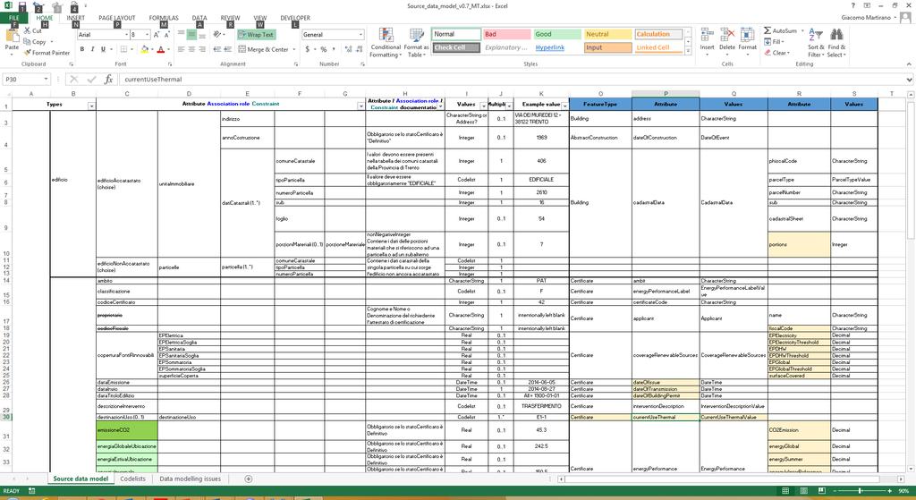
4 INSPIRE core schemas extension Content and structure of INSPIRE application schemas for theme Buildings 4
5 INSPIRE core schemas extension INSPIRE extended data models INSPIRE core data models Energy Pilot extended data models CityGML Energy ADE 5
6 INSPIRE core schemas extension 6


7 INSPIRE core schemas extension INSPIRE CORE DRAFT INSPIRE EXTENDED NEW FEATURE TYPES 7
, which is atomic, functionally independent, and")
8 Building unit A BuildingUnit is a subdivision of Building with its own lockable access from the outside or from a common area (i.e. not from another BuildingUnit), which is atomic, functionally independent, and may be separately sold, rented out, inherited, etc. 8

9 Re3gistry implementation 9
10 Data transformation 10

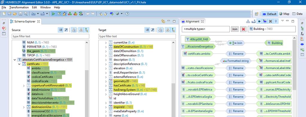
11 Data transformation 11
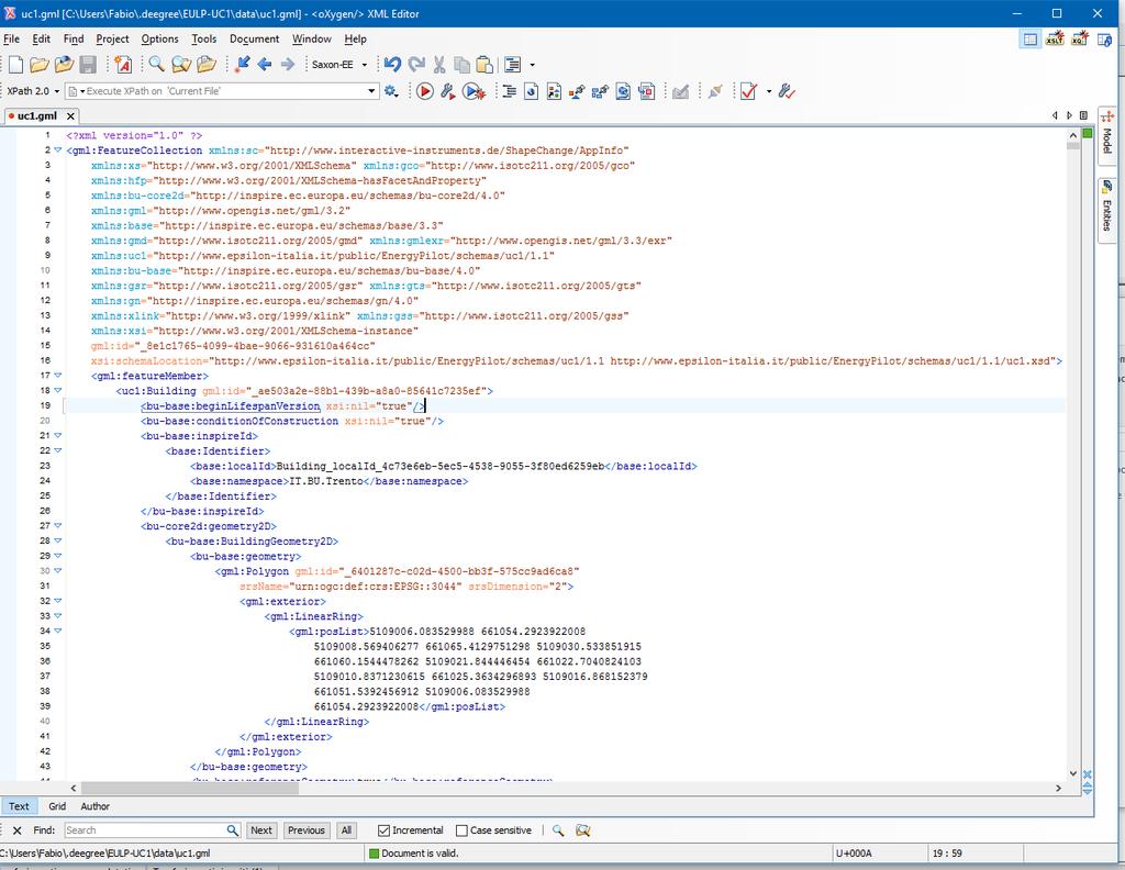
12 Data validation 12
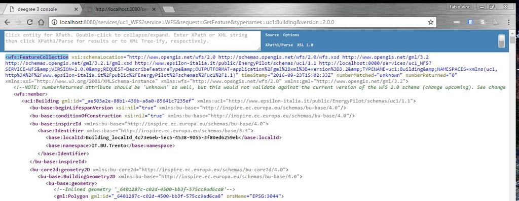
13 Data publication 13


14 Data use 14
15 ELISE Energy pilot - INSPIRE Web App Web app to facilitate access to and use of INSPIRE compliant harmonised data also by non-gis experts Requirements Specific type of data to be accessed; Elaborations eventually required on the data to be accessed (e.g. transformations); Common libraries (supporting the inbound data format) User interface 15
16 ELISE Energy pilot - INSPIRE Web App The prototype Dataset: Energy Performance Certificate Dataset from APRIE (public buildings) Data format: INSPIRE GML 3.2 (produced using an INSPIRE extended schema) Web map library: OpenLayers / Leaflet 16

17 ELISE Energy pilot - INSPIRE Web App Prototype available for test! 17


18 ELISE Energy pilot - INSPIRE SDS Conformance class: interoperable INSPIRE SDS metadata 18
19 Next steps Improve Persistent Identifier management in the target schema Apply HALE alignment to all dataset Deploy WFS on a publicly accessible server Enrich code list register content with more detailed description of code list values and translation in English Support partner to operationalize the pilot workflow into its organization Re-use pilot workflow in other Regions/Countries 19
20 Thank The ELISE Energy Pilot in the INSPIRE Knowledge Base: 20

21 ISA² programme You click, we link. Stay in touch Run by the ISA Unit at DIGIT (European Commission) with 131 M budget, the ISA 2 programme provides public administrations, businesses and citizens with specifications and standards, software and services to reduce administrative burdens. 21
Web apps for INSPIRE: the ELISE Energy pilot example
 Web apps for INSPIRE: the ELISE Energy pilot example 6 September 2017 Authors: Daniele Francioli Giacomo Martirano Maria Teresa Borzacchiello Francesco Pignatelli Outline Overview of the ELISE Energy Pilot
The enabling role of geospatial information in the European energy policies
 The European Commission s science and knowledge service Joint Research Centre The enabling role of geospatial information in the European energy policies Francesco Pignatelli Kehl (DE), 5 September 2017
Rui Reis, Maria José Vale, Marcelo Ribeiro, Bruno Meneses Geospatial World Forum 2016, May 2016, Rotterdam
 LC change detection and planning indicators Rui Reis, Maria José Vale, Marcelo Ribeiro, Bruno Meneses Summary 1. 2. 3. 4. 5. 6. 7. 8. Introduction Pilot overview Data description Inspire data harmonization
Consolidation Team INSPIRE Annex I data specifications testing Call for Participation
 INSPIRE Infrastructure for Spatial Information in Europe Technical documents Consolidation Team INSPIRE Annex I data specifications testing Call for Participation Title INSPIRE Annex I data specifications
Validating services and data in an SDI
 Validating services and data in an SDI Presentation to: By: Date: INSPIRE Conference Clemens Portele, Jon Herrmann, Roy Mellum 30 September 2016 4 October, 2016 ELF is the response from the European Mapping
Christian Ansorge 27th April CDDA webinar 27th April Linked Approach as reporting mechanism
 Christian Ansorge 27th April 2017 CDDA webinar 27th April 2017 Linked Approach as reporting mechanism Generic Linked Approach Scope Background and motivation for reporting reusing INSPIRE Introduction
From the INSPIRE Engine Room
 From the INSPIRE Engine Room Michael Lutz ENiiG Conference, Lisbon 9 November 2016 Joint Research Centre the European Commission's in-house science service The JRC's role in INSPIRE Support MS in implementation
INSPIRE tools What's new?
 INSPIRE tools What's new? Michael Lutz INSPIRE Conference, Antwerp 18 September 2018 Joint Research Centre The European Commission s science and knowledge service INSPIRE reference validator Why a reference
DanubeGIS User Manual Document number: Version: 1 Date: 11-Nov-2016
 DanubeGIS User Manual Document number: Version: 1 Date: 11-Nov-2016 Imprint Published by: ICPDR International Commission for the Protection of the Danube River ICPDR 2016 Contact ICPDR Secretariat Vienna
GeoSmartCity Workshop Katowice October 26 th 2016
 1 GeoSmartCity Workshop Katowice October 26 th 2016 The GSC extended data models and the data harmonisation methodology Fabio Vinci, Giacomo Martirano, Stefania Morrone f.vinci@epsilon-italia.it, g.martirano@epsilon-italia.it,
Evolution of INSPIRE interoperability solutions for e-government
 Evolution of INSPIRE interoperability solutions for e-government INSPIRE Implementation State-of-Play 26/05/2015 Robin S. Smith www.jrc.ec.europa.eu Serving society Stimulating innovation Supporting legislation
ISA Action 1.17: A Reusable INSPIRE Reference Platform (ARE3NA)
") ISA Action 1.17: A Reusable INSPIRE Reference Platform (ARE3NA) Expert contract supporting the Study on RDF and PIDs for INSPIRE Deliverable D.EC.3.2 RDF in INSPIRE Open issues, tools, and implications
ISA Action 1.17: A Reusable INSPIRE Reference Platform (ARE3NA) Expert contract supporting the Study on RDF and PIDs for INSPIRE Deliverable D.EC.3.2 RDF in INSPIRE Open issues, tools, and implications
HUMBOLDT Application Scenario: Protected Areas
 CC by Erlend Schei Copyright by Kecko Copyright by Michael Bezzina CC by Gunnar Ries Copyright by Michael Bezzina Copyright by Michael Bezzina Copyright by Michael Bezzina CC by fs999 CC by Jordan Nielsen
European Location Framework (ELF) acting as a facilitator implementing INSPIRE
 acting as a facilitator implementing INSPIRE") www.eurogeographics.org European Location Framework (ELF) acting as a facilitator implementing INSPIRE Saulius Urbanas, Mick Cory (EuroGeographics) 29 October 2016 Copyright 2013 EuroGeographics EuroGeographics
www.eurogeographics.org European Location Framework (ELF) acting as a facilitator implementing INSPIRE Saulius Urbanas, Mick Cory (EuroGeographics) 29 October 2016 Copyright 2013 EuroGeographics EuroGeographics
INSPIRE & Environment Data in the EU
 INSPIRE & Environment Data in the EU Andrea Perego Research Data infrastructures for Environmental related Societal Challenges Workshop @ pre-rda P6 Workshops, Paris 22 September 2015 INSPIRE in a nutshell
Validation in the Netherlands and European Location Framework
 Validation in the Netherlands and European Location Framework INSPIRE Workshop on validation and conformity testing 15 16 May 2014 Thijs Brentjens Contents Geonovum and ELF INSPIRE INSPIRE in the Netherlands
Spatial Data on the Web
 Spatial Data on the Web Tools and guidance for data providers The European Commission s science and knowledge service W3C Data on the Web Best Practices 35 W3C/OGC Spatial Data on the Web Best Practices
VICTOR I. SERNA FUNDACIÓN CARTIF GIULIA MASSA FUNDACIÓN CARTIF
 DEMAND CHARACTERSATION BY INSPIRE BASED EPC GENERATION FOR ENERGY URBAN PLANNING TOWARDS THE DECARBONISATION OF BUILDINGS AND DISTRICTS GEMA HERNÁNDEZ MORAL FUNDACIÓN CARTIF CÉSAR VALMASEDA TRANQUE FUNDACIÓN
Introduction to INSPIRE. Network Services
 Introduction to INSPIRE. Network Services European Commission Joint Research Centre Institute for Environment and Sustainability Digital Earth and Reference Data Unit www.jrc.ec.europa.eu Serving society
Landslide Damage on Chemin de Fer de la Mure near Grenoble,
 Contents 1 What is the INSPIRE directive, and why is it important?... 3 1.1 What is the aim of this document?... 4 1.2 Who will this document be useful to?... 4 2 An overview of INSPIRE specifications...
GENeric European Sustainable Information Space for Environment.
 GENeric European Sustainable Information Space for Environment http://www.genesis-fp7.eu/ Outline Introduction The GENESIS FP7 project The GENESIS solution s architecture GENESIS experience with INSPIRE
Monitoring and Reporting Drafting Team Monitoring Indicators Justification Document
 INSPIRE Infrastructure for Spatial Information in Europe Monitoring and Reporting Drafting Team Monitoring Indicators Justification Document Title Draft INSPIRE Monitoring Indicators Justification Document
How to Create a European INSPIRE Compliant Data Specification. Anja Hopfstock, BKG (Germany) Morten Borrebæk, SK (Norway)
 Morten Borrebæk, SK (Norway)") How to Create a European INSPIRE Compliant Data Specification Anja Hopfstock, BKG (Germany) Morten Borrebæk, SK (Norway) ESDIN Key Goals Further the ambition of the European Commission to create a European
How to Create a European INSPIRE Compliant Data Specification Anja Hopfstock, BKG (Germany) Morten Borrebæk, SK (Norway) ESDIN Key Goals Further the ambition of the European Commission to create a European
Standards, standardisation & INSPIRE Status, issues, opportunities
 Standards, standardisation & INSPIRE Status, issues, opportunities INSPIRE Coordination Team 6 th MIG meeting, 13-14 June 2017 Joint Research Centre The European Commission's science and knowledge service
Detailed analysis + Integration plan
 Outline Integration methodology Detailed analysis + Integration plan Conclusions 2 Outline Integration methodology Detailed analysis + Integration plan Conclusions 3 EULF-ISA Integration: methodology Phase
POSEIDON, INSPIRE updated citizen science project. Andrej Abramić, Alejandro Garcia Mendoza, Ricardo Haroun Tabraue and José Juan Castro Hernández
 POSEIDON, INSPIRE updated citizen science project Andrej Abramić, Alejandro Garcia Mendoza, Ricardo Haroun Tabraue and José Juan Castro Hernández Programa POSEIDON http://www.programaposeidon.eu Citizen
Using INSPIRE Services for Reporting and Exchange of Air Quality Information under CAFE Directive Test bed Results
 Using INSPIRE Services for Reporting and Exchange of Air Quality Information under CAFE Directive Test bed Results Alina Kmiecik, Dominik Kobus, Magdalena Bednarek, Piotr Krok, Anna Zamolska 26,6/2012,
INSPIRE: The ESRI Vision. Tina Hahn, GIS Consultant, ESRI(UK) Miguel Paredes, GIS Consultant, ESRI(UK)
 Miguel Paredes, GIS Consultant, ESRI(UK)") INSPIRE: The ESRI Vision Tina Hahn, GIS Consultant, ESRI(UK) Miguel Paredes, GIS Consultant, ESRI(UK) Overview Who are we? Introduction to ESRI Inc. and ESRI(UK) Presenters ArcGIS The ESRI Solution to
INSPIRE: The ESRI Vision Tina Hahn, GIS Consultant, ESRI(UK) Miguel Paredes, GIS Consultant, ESRI(UK) Overview Who are we? Introduction to ESRI Inc. and ESRI(UK) Presenters ArcGIS The ESRI Solution to
Initial Operating Capability & The INSPIRE Community Geoportal
 INSPIRE Conference, Rotterdam, 15 19 June 2009 1 Infrastructure for Spatial Information in the European Community Initial Operating Capability & The INSPIRE Community Geoportal EC INSPIRE GEOPORTAL TEAM
Spatial Data on the Web
 Spatial Data on the Web Tools and guidance for data providers Clemens Portele, Andreas Zahnen, Michael Lutz, Alexander Kotsev The European Commission s science and knowledge service Joint Research Centre
Integration of INSPIRE & SDMX data infrastructures for the 2021 population and housing census
 Integration of INSPIRE & SDMX data infrastructures for the 2021 population and housing census Nadezhda VLAHOVA, Fabian BACH, Ekkehard PETRI *, Vlado CETL, Hannes REUTER European Commission (*ekkehard.petri@ec.europa.eu
Reporting and Exchange of Air Quality Information Under CAFE Directive Using INSPIRE Services Testbed Results
 Reporting and Exchange of Air Quality Information Under CAFE Directive Using INSPIRE Services Testbed Results Alina Kmiecik, Dominik Kobus, Magdalena Bednarek, Anna Zamolska, Piotr Krok, Marek Brylski,
Workshop Data Modelling [en]
![Workshop Data Modelling [en]](/thumbs/87/95069410.jpg "Workshop Data Modelling [en]") Workshop Data Modelling [en] Thorsten Reitz, wetransform INSPIRE and Beyond 2018 24.05.2018 Wetransform GmbH - Why do we create data models at all? - What processes can we use to create models? - What
Workshop Data Modelling [en] Thorsten Reitz, wetransform INSPIRE and Beyond 2018 24.05.2018 Wetransform GmbH - Why do we create data models at all? - What processes can we use to create models? - What
SDI Workshop ESDIN Best Practices INSPIRE conference, Edinburgh. Arnulf Christl, Metaspatial
 SDI Workshop ESDIN Best Practices 2011-06-28 INSPIRE conference, Edinburgh Arnulf Christl, Metaspatial Download this slide set as ODP or PDF at http://arnulf.us/publications Arnulf Christl Geospatially
Exploitation towards Thematic Communities, Training Framework and stakeholders involvement
 Exploitation towards Thematic Communities, Training Framework and stakeholders involvement Giorgio Saio GISIG eenvplus Workshop INSPIRE Conference, Florence (IT), 24 June 2013 Exploitation prospects eenvplus
ELF download services
 ELF download services Presentation to: Author: Date: ELF workshop in Moldova Marcin Grudzień 8 h September2015 14 September, 2015 Plan Introduction Specification documents The envisaged production process
INSPIRE roadmap and architecture: lessons learned INSPIRE 2017
 INSPIRE roadmap and architecture: lessons learned INSPIRE 2017 Stijn Goedertier GIM Thierry Meessen GIM Jeff Konnen ACT Luxembourg Patrick Weber ACT Luxembourg 1 Administration du cadastre et de la topographie
How to Report on Data Quality in a Multinational Environment?
 How to Report on Data Quality in a Multinational Environment? Presentation to: By: Date: SDMQ2015 Anja Hopfstock, BKG 20.01.2015 Agenda ELF architecture Data Quality Management Data Quality Reporting Summary
CREATING SMART TRANSPORT SERVICES BY FACILITATING THE RE-USE OF OPEN GIS DATA
 OPEN TRANSPORT NET TOMAS MILDORF 16 JUNE 2014 INSPIRE CONFERENCE 2014, AALBORG, DENMARK CREATING SMART TRANSPORT SERVICES BY FACILITATING THE RE-USE OF OPEN GIS DATA 2 1 OTN AT A GLANCE Full title OpenTransportNet
Workshop 4.4: Lessons Learned and Best Practices from GI-SDI Projects II
 Workshop 4.4: Lessons Learned and Best Practices from GI-SDI Projects II María Cabello EURADIN technical coordinator On behalf of the consortium mcabello@tracasa.es euradin@navarra.es Scope E-Content Plus
Closing the INSPIRE Implementation Gap by Contributing to SDI Technology Development
 Closing the INSPIRE Implementation Gap by Contributing to SDI Technology Development Experiences from the Envibase project Lena Hallin-Pihlatie, Riikka Repo, Suvi Hatunen, Ilkka Rinne Finnish Environment
Setting up the Ihlet Social Cadastre
 Setting up the Ihlet Social Cadastre Ihlet KHT Dr. Attila Molnár, GI consultant Bela Jarolics Rome, Italy TOPICS Goal of the project Architecture Database Solution Standards, communication Metadata Security
A5.2-D3 [3.5] Workflow Design and Construction Service Component Specification. Eva Klien (FHG), Christine Giger (ETHZ), Dániel Kristóf (FOMI)
![A5.2-D3 [3.5] Workflow Design and Construction Service Component Specification. Eva Klien (FHG), Christine Giger (ETHZ), Dániel Kristóf (FOMI)](/thumbs/90/102649368.jpg "A5.2-D3 [3.5] Workflow Design and Construction Service Component Specification. Eva Klien (FHG), Christine Giger (ETHZ), Dániel Kristóf (FOMI)") Title: A5.2-D3 [3.0] A Lightweight Introduction to the HUMBOLDT Framework V3.0 Author(s)/Organisation(s): Daniel Fitzner (FhG), Thorsten Reitz (FhG) Working Group: Architecture Team / WP5 References: A5.2-D3
Title: A5.2-D3 [3.0] A Lightweight Introduction to the HUMBOLDT Framework V3.0 Author(s)/Organisation(s): Daniel Fitzner (FhG), Thorsten Reitz (FhG) Working Group: Architecture Team / WP5 References: A5.2-D3
InfraGML. Linking pin between Geo and BIM. 4 november 2014
 InfraGML Linking pin between Geo and BIM Marcel Reuvers (Geonovum) 4 november 2014 GIS Roads DTM GIS scope: Scale 1:500 1:25:000 Coordinates system CRS Features Topology networks Themes Cables and pipes
Data transformation Addresses
 Data transformation Addresses according to INSPIRE Ing. Michal Med ČÚZK April 17, 2015 1 Introduction 2 3 4 Introduction About data and services INSPIRE harmonised data and download and view service were
EFIR & A Reusable INSPIRE Reference Platform
 JOINING UP GOVERNMENTS EFIR & A Reusable INSPIRE Reference Platform Robin S. Smith & Andrea Perego EFIR Workshop 24 April 2013 Outline INSPIRE (a reminder we hope) ISA Action 1.17 Our Assets Initial reaction
HMA Standardisation Status
 HMA Standardisation Status GSCB Meeting, 18-19 June 2009, Frascati P.G. Marchetti, ESA Y. Coene, SPACEBEL GSCB Meeting, 18 June 2009 Slide 1 Overview Context and Objectives Evolution of specifications
Testing - an essential aspect of establishing an SDI
 Testing - an essential aspect of establishing an SDI Clemens Portele, Anders Östman, Michael Koutroumpas, Xin He, Janne Kovanen, Markus Schneider, Andriani Skopeliti INSPIRE Conference 2011 30 June 2011
Methodological approach for cross-theme harmonization of Polish spatial data sets the case study for the Annex I themes
 Methodological approach for cross-theme harmonization of Polish spatial data sets the case study for the Annex I themes Elżbieta Bielecka, Agnieszka Zwirowicz-Rutkowska, Alina Kmiecik, Marek Brylski, Magdalena
Compass INSPIRE Services. Compass INSPIRE Services. White Paper Compass Informatics Limited Block 8, Blackrock Business
 Compass INSPIRE Services White Paper 2010 Compass INSPIRE Services Compass Informatics Limited Block 8, Blackrock Business Park, Carysfort Avenue, Blackrock, County Dublin, Ireland Contact Us: +353 1 2104580
Infrastructure for Spatial Information in Europe. Proposed action for update of MIWP: Alternative encodings for INSPIRE data
 INSPIRE Infrastructure for Spatial Information in Europe Proposed action for update of MIWP: Alternative encodings for INSPIRE data Type Creator MIWP Action fiche DG ENV Date/status/version 20/11/2017
The cadastral data and standards based on XML in Poland
 The cadastral data and standards based on XML in Poland Jarosław Bydłosz, Piotr Parzych AGH University of Science and Technology Cracow, Poland 1 XML XML Extensible Markup Language Extensible Markup Language
Validation experience
 Validation experience Paloma Abad Head of SDI Department SDI Workshop 26-06-2018 INSPIRE KEN INSPIRE KEN, june 2018 1 Points 1. Introduction 2. Interoperability 3. Geoportal Thematic Viewer 4. Conclusions
The European Commission s science and knowledge service. Joint Research Centre
 The European Commission s science and knowledge service Joint Research Centre GeoDCAT-AP The story so far Andrea Perego, Antonio Rotundo, Lieven Raes GeoDCAT-AP Webinar 6 June 2018 What is GeoDCAT-AP Geospatial
INSPIRE overview and possible applications for IED and E-PRTR e- Reporting Alexander Kotsev
 INSPIRE overview and possible applications for IED and E-PRTR e- Reporting Alexander Kotsev www.jrc.ec.europa.eu Serving society Stimulating innovation Supporting legislation The European data puzzle 24
Toward Horizon 2020: INSPIRE, PSI and other EU policies on data sharing and standardization
 Toward Horizon 2020: INSPIRE, PSI and other EU policies on data sharing and standardization www.jrc.ec.europa.eu Serving society Stimulating innovation Supporting legislation The Mission of the Joint Research
INSPIRE status report
 INSPIRE Team INSPIRE Status report 29/10/2010 Page 1 of 7 INSPIRE status report Table of contents 1 INTRODUCTION... 1 2 INSPIRE STATUS... 2 2.1 BACKGROUND AND RATIONAL... 2 2.2 STAKEHOLDER PARTICIPATION...
The GIGAS Methodology
 The GIGAS Methodology Pier Giorgio Marchetti European Space Agency Earth Observation Programme Ground Segment Department pier.giorgio.marchetti@esa.int GIGAS Objectives GIGAS has the goal to promote the
Addressing the needs of INSPIRE: The Challenges of improving Interoperability within the European Union
 Addressing the needs of INSPIRE: The Challenges of improving Interoperability within the European Union Andrew Coote Facilitator, Addresses Thematic Working Group andrew.coote@consultingwhere.com Disclaimer
The UK Marine Environmental Data and Information Network MEDIN
 The UK Marine Environmental Data and Information Network MEDIN M. Charlesworth, R. Lowry, H. Freeman, J. Rapaport, B Seeley Content MEDIN - a brief overview for context Discovery Metadata Standard and
Geographical Base Registries for Flanders
 Geographical Base Registries for Flanders Ziggy Vanlishout Flemish Geographical Information Agency Layout FGIA (Flemish Geographical Information Agency) Project 'Geographical Base Registries' Data Modelling
Interoperability & Archives in the European Commission
 Interoperability & Archives in the European Commission By Natalia ARISTIMUÑO PEREZ Head of Interoperability Unit at Directorate- General for Informatics (DG DIGIT) European Commission High value added
Project European CDDA and INSPIRE : scope, transformation workflow and mapping rules
 Project European CDDA and INSPIRE : scope, transformation workflow and mapping rules INSPIRE Conference 2014 Workshop: Implementing Existing European Spatial Data of Designated Areas Based on the INSPIRE
To Vector, or to Raster? Coverage Processing and Publishing for INSPIRE Annex II/III
 To Vector, or to Raster? Coverage Processing and Publishing for INSPIRE Annex II/III Thorsten Reitz, wetransform GmbH Markus Braun, M.O.S.S. Computer Graphik Systeme GmbH 15.09.2017 Agenda & Introduction
Framework specification, logical architecture, physical architecture, requirements, use cases.
 Title: A5.2-D3 3.3.1 Alignment Editor Specification Editor(s)/Organisation(s): Thorsten Reitz (Fraunhofer IGD) Contributing Authors: Thorsten Reitz (Fraunhofer IGD), Marian de Vries (TUD) References: A1.8-D4
Rolling work programme for INSPIRE maintenance and implementation
 INSPIRE Maintenance and Implementation Group (MIG) Rolling work programme for INSPIRE maintenance and implementation Creator Michael Lutz Date of last update 2013-12-16 Subject Publisher Type Description
Land Cover spatial datasets harmonization in Portugal using HALE
 Land Cover spatial datasets harmonization in Portugal using HALE Teresa Zuna, Alexandra Fonseca, Danilo Furtado, Ana Luísa Gomes, André Serronha, Paulo Patrício Introduction DGT is the entity responsible
Guidelines for the encoding of spatial data
 INSPIRE Infrastructure for Spatial Information in Europe Guidelines for the encoding of spatial data Title Status Creator Date 2012-06-15 Subject Publisher Type Description Contributor Format Source Rights
Quality control service for Inspire data
 Quality control service for Inspire data INSPIRE Conference 2014 Aalborg Anders Foureaux Process Manager Data feeds Data hosting Environmental Informations Systems Unit Reasearch and Assessment Department
Challenges to be INSPIRE compliant: CDDA into Protected Sites
 Challenges to be INSPIRE compliant: CDDA into Protected Sites María Cabello Pedro Mendive Summary Background The project Lessons learned Harmonizati on process Background Annex 1 Addresses Protected Sites
The federal geo-platform:
 The federal geo-platform: Targeting the statistical community Nathalie Delattre (IGN Belgium), Pierre Jamagne (Statistics Belgium), Ann Crabbé (KULeuven/SADL) INSPIRE Conference, Strasbourg 6-8 septembre
Statistical Viewer. Coping with the Complexity
 Statistical Viewer Coping with the Complexity Overview What s DataCove and Ghosting EuroStat as a Data Resource DataCove Statistical Viewer The Way from Here to There Conclusions What We Do Data Modelling:
GOVSEC - SECURE GOVERNANCE ( ) IDENTIFICATION OF THE ACTION EXECUTIVE SUMMARY. Service in charge
 IDENTIFICATION OF THE ACTION EXECUTIVE SUMMARY. Service in charge") 328 8.16 GOVSEC - SECURE GOVERNANCE (2018.09) 8.16.1 IDENTIFICATION OF THE ACTION Service in charge Associated Services DIGIT EU Institutions, Member States 8.16.2 EXECUTIVE SUMMARY With the emergence
328 8.16 GOVSEC - SECURE GOVERNANCE (2018.09) 8.16.1 IDENTIFICATION OF THE ACTION Service in charge Associated Services DIGIT EU Institutions, Member States 8.16.2 EXECUTIVE SUMMARY With the emergence
SEXTANT 1. Purpose of the Application
 SEXTANT 1. Purpose of the Application Sextant has been used in the domains of Earth Observation and Environment by presenting its browsing and visualization capabilities using a number of link geospatial
Building a missing item in INSPIRE: The Re3gistry
 Building a missing item in INSPIRE: The Re3gistry www.jrc.ec.europa.eu Serving society Stimulating innovation Supporting legislation Key pillars of data interoperability Conceptual data models Encoding
European Interoperability Reference Architecture (EIRA) overview
 overview") European Interoperability Reference Architecture (EIRA) overview Version 0.8.3 beta 09/01/2015 ISA Action 2.1: European Interoperability Architecture Specific Contract N. 54 Framework contract N. DI/07171
European Interoperability Reference Architecture (EIRA) overview Version 0.8.3 beta 09/01/2015 ISA Action 2.1: European Interoperability Architecture Specific Contract N. 54 Framework contract N. DI/07171
INSPIRE & Linked Data: Bridging the Gap Part II: Tools for linked INSPIRE data
 Making the Web an Exploratory Place for Geospatial Knowledge INSPIRE & Linked Data: Bridging the Gap Part II: Tools for linked INSPIRE data Michalis Alexakis Spiros Athanasiou Nikos Georgomanolis Giorgos
DATA VALIDATION AGAINST SCHEMA AND SOURCE DATA
 DATA VALIDATION AGAINST SCHEMA AND SOURCE DATA didier.bouteloup@ign.fr; dominique.laurent@ign.fr 3 June 2016 ign.fr Context IGN has performed data validation twice On test INSPIRE data (2013-2014) On ELF
INSPIRE Biodiversity Mashup
 INSPIRE Biodiversity Mashup Current Status 1 Kathi Schleidt Katharina.Schleidt@umweltbundesamt.at Martin Koška martin.koska@sazp.sk Peter Mozolík peter.mozolik@sazp.sk Barbara Pratschner - babsip@mac.com
Relation between Geospatial information projects related to GBIF
 Relation between Geospatial information projects related to GBIF Synthesys 3.6-Synthesys 3.7-GBIF.DE- BioGeomancer The most up to date work can always be found at: http://www.biogeografia.com/synthesys
Study and guidelines on Geospatial Linked Data as part of ISA Action 1.17 Resource Description Framework
 DG Joint Research Center Study and guidelines on Geospatial Linked Data as part of ISA Action 1.17 Resource Description Framework 6 th of May 2014 Danny Vandenbroucke Diederik Tirry Agenda 1 Introduction
FP7-INFRASTRUCTURES Grant Agreement no Scoping Study for a pan-european Geological Data Infrastructure D 4.4
 FP7-INFRASTRUCTURES-2012-1 Grant Agreement no. 312845 Scoping Study for a pan-european Geological Data Infrastructure D 4.4 Report on recommendations for implementation of the EGDI Deliverable number D4.4
INSPIRE relevant policy developments in the EU's digital economy initiatives
 INSPIRE relevant policy developments in the EU's digital economy initiatives Interoperability Solutions and common Frameworks for European public Administrations, businesses and citizens as a means of
Daniela Cristiana Docan I 6th Sept. I INSPIRE Conference 2017, Strasbourg. EEA Data Quality Management supporting INSPIRE implementation
 Daniela Cristiana Docan I 6th Sept. I INSPIRE Conference 2017, Strasbourg EEA Data Quality Management supporting INSPIRE implementation Data Quality in INSPIRE INSPIRE Technical Guidelines use ISO 19157
SEIS. (Shared Environmental Information System) From concept to information services
 From concept to information services") SEIS (Shared Environmental Information System) From concept to information services Stefan Jensen EEA supported by Sheila Cryan and Jon Maidens GSDI 11, Rotterdam 19.6.2009 What is SEIS is about... Sharing
SEIS (Shared Environmental Information System) From concept to information services Stefan Jensen EEA supported by Sheila Cryan and Jon Maidens GSDI 11, Rotterdam 19.6.2009 What is SEIS is about... Sharing
FROM THE REGIONAL TO NATIONAL ENVIRONMENTAL SYSTEM: A COMMON APPROACH TO ENVIRONMENTAL INDEX DATA FLOW
 FROM THE REGIONAL TO NATIONAL ENVIRONMENTAL SYSTEM: A COMMON APPROACH TO ENVIRONMENTAL INDEX DATA FLOW Carlo Cipolloni ISPRA carlo.cipolloni@isprambiente.it With the contribute of some Regional Environmental
e SOTER Informatics Framework Key lessons learnt
 Workshop to develop 250,000 soil database for Danube Basin using e SOTER methodology JRC, Ispra, Italy, 5 6/Feb/2015 e SOTER Informatics Framework Key lessons learnt Dr Stephen Hallett Cranfield University,
Open Source
 Open Source Software @EC and EU-FOSSA 2 Marek Przybyszewski and Saranjit Arora DIGIT Directorate-General for European Commission Open Source Summit Europe 2018 Edinburgh, 22-24 October 2018 Agenda Open
/// INTEROPERABILITY BETWEEN METADATA STANDARDS: A REFERENCE IMPLEMENTATION FOR METADATA CATALOGUES
 /// Position Paper /// INTEROPERABILITY BETWEEN METADATA STANDARDS: A REFERENCE IMPLEMENTATION FOR METADATA CATALOGUES /// Keywords: Public administration, Metadata, Geographical Information, Geospatial
Leveraging OGC Services in ArcGIS Server. Satish Sankaran, Esri Yingqi Tang, Esri
 Leveraging OGC Services in ArcGIS Server Satish Sankaran, Esri Yingqi Tang, Esri GIS Creating and Managing Geo Information Products - Proprietary - Open Specifications - Standards Dissemination of Geo
A5.2-D3 [3.5] Workflow Design and Construction Service Component Specification
![A5.2-D3 [3.5] Workflow Design and Construction Service Component Specification](/thumbs/88/114572244.jpg "A5.2-D3 [3.5] Workflow Design and Construction Service Component Specification") Title: A5.2-D3 [3.5] Workflow Design and Construction Service Component Specification Author(s)/Organisation(s): Daniel Fitzner (FHG), Moses Gone (FHG) Working Group: Architecture Team / WP5 References:
Title: A5.2-D3 [3.5] Workflow Design and Construction Service Component Specification Author(s)/Organisation(s): Daniel Fitzner (FHG), Moses Gone (FHG) Working Group: Architecture Team / WP5 References:
Support-EAM. Publishable Executive Summary SIXTH FRAMEWORK PROGRAMME. Project/Contract no. : IST SSA. the 6th Framework Programme
 Support-EAM Supporting the creation of an eaccessibility Mark SIXTH FRAMEWORK PROGRAMME Project/Contract no. : IST-2-004754-SSA Project acronym: Project full title: Instrument: Thematic Priority: SUPPORT-
geobrowser3d.com The Power of 3D GIS Tools in your Browser
 geobrowser3d.com 1 The Power of 3D GIS Tools in your Browser Overview Introduction Modules Success Stories Build your own What is GeoBrowser3D Interactive 3D visualization system Modular platform OGC compliant
INSPIRE compliant e-reporting under the air quality directives from a member state perspective (Belgium)
") INSPIRE compliant e-reporting under the air quality directives from a member state perspective (Belgium) Olav Peeters Belgian Interregional Environment Agency (IRCEL CELINE) Content Who are we (IRCEL CELINE)
INSPIRE compliant e-reporting under the air quality directives from a member state perspective (Belgium) Olav Peeters Belgian Interregional Environment Agency (IRCEL CELINE) Content Who are we (IRCEL CELINE)
Science Europe Consultation on Research Data Management
 Science Europe Consultation on Research Data Management Consultation available until 30 April 2018 at http://scieur.org/rdm-consultation Introduction Science Europe and the Netherlands Organisation for
News in Download services in the Czech Republic. Petr Souček Czech Office for Surveying, Mapping and Cadastre Prague, Czech Republic
 News in Download services in the Czech Republic Petr Souček Czech Office for Surveying, Mapping and Cadastre Prague, Czech Republic Topics The infrastructure The experience with themes Parcels (CP), Addresses
DCAT-AP FOR DATA PORTALS IN EUROPE
 DCAT-AP FOR DATA PORTALS IN EUROPE BRECHT WYNS PWC EU SERVICES 30 November 2016 SDSVoc, Amsterdam Prepared for the ISA 2 programme by PwC EU Services AUTHORS: BRECHT WYNS, MAKX DEKKERS, NIKOLAOS LOUTAS,
Initial GMES Service for Geospatial Reference Data Access. Remote Sensing Department. INDRA ESPACIO
 Initial GMES Service for Geospatial Reference Data Access Remote Sensing Department. INDRA ESPACIO Brussels, 260-09-2011 CONTENT 01 Overview 02 EU-DEM 03 Hydrography 04 Production Coordination 05 Access
Global ebusiness Interoperability Test Beds (GITB) Test Registry and Repository User Guide
 Test Registry and Repository User Guide") Global ebusiness Interoperability Test Beds (GITB) Test Registry and Repository User Guide CEN Workshop GITB Phase 3 October 2015 Global ebusiness Interoperability Test Beds (GITB) 2 Table of Contents
Global ebusiness Interoperability Test Beds (GITB) Test Registry and Repository User Guide CEN Workshop GITB Phase 3 October 2015 Global ebusiness Interoperability Test Beds (GITB) 2 Table of Contents
Training Framework LINKVIT
 Geographical Infomation Systems International Group Training Framework LINKVIT G. Saio GISIG g.saio@gisig.it 1 www.linkvit.eu Project aims 2 LINKVIT deals with Digital Competence as defined in the Key