Validating services and data in an SDI
|
|
|
- Milo Tucker
- 5 years ago
- Views:
Transcription


1 Validating services and data in an SDI Presentation to: By: Date: INSPIRE Conference Clemens Portele, Jon Herrmann, Roy Mellum 30 September October, 2016

2 ELF is the response from the European Mapping and Cadastral Authorities (NMCAs) to requirements at the European arena a 44 month project co financed by the European Commission and comprising 40 partners, including 23 NMCAs running from March 2013 to October
3 ELF Services short overview Currently a total of more than 100 services from 13+ service providers ALL (to be) validated / tested! Pan European services (single access points) View services ELF Topographic Basemap (WMTS) and ELF Cadastral Index Map (WMS) Download services WFS 2.0, GML A service cascade built on 70+ national services Thematic services providing 11 INSPIRE themes and more than 120 attributes. INSPIRE 3.0 and INSPIRE 4.0/ELF1.0
4 ELF Quality and Testing responsibilities Tier Services and Data contents Responsible party User Tier Applications Users Central Platform Tier Cascaded view services ELF Core team Cascaded download services ELF Security National Service Tier FR Nat services BE Nat services National service provider National Data Tier Fr data Be data xx data Data owner/data provider
5 ELF Quality and Testing tools Test Validator Tools used Hosted by OGC conformance OGC CITE Tests for WFS 2.0, GML 3.2, WMS 1.3, WMTS 1.0 TEAM Engine, Test NG OGC, local tests possible Service metadata INSPIRE Geoportal Metadata Validator JRC INSPIRE/ELF requirements on services, schemas and GML encoding ETF Web App configured with INSPIRE/ELF specific tests ETF, SoapUI, BaseX interactive instruments, local tests possible INSPIRE Service capacity & Spatineo Performance monitor NLSFI performance INSPIRE Service availability Spatineo monitor NLSFI Data quality Various GIS ELF quality tools, Esri, 1Spatial, Snowflake, FME, etc. Local tests by NMCA
6 Service validation in ELF Where are we? In general the existing service validation tools are still somewhat immature Functionality Error reporting View service validation is doable, WFS currently hard to do good enough Overall status : not good enough, but useable for ELF at an absolute minimum level A service not conforming to standards is not usable Service validation is for help, not a punishment Integrate service validation in your development procedures
7 ELF Quality and Testing tools Test Validator Tools used Hosted by OGC conformance OGC CITE Tests for WFS 2.0, GML 3.2, WMS 1.3, WMTS 1.0 TEAM Engine, Test NG OGC, local tests possible Service metadata INSPIRE Geoportal Metadata Validator JRC INSPIRE/ELF requirements on services, schemas and GML encoding ETF WebApp configured with INSPIRE/ELF specific tests ETF, SoapUI, BaseX interactive instruments, local tests possible INSPIRE Service capacity & Spatineo Performance monitor NLSFI performance INSPIRE Service availability Spatineo monitor NLSFI Data quality Various GIS ELF quality tools, Esri, 1Spatial, Snowflake, FME, etc. Local tests by NMCA
8 ETF A test framework for testing SDI services, datasets and metadata Builds on existing, widely used open source tools SoapUI for web service tests BaseX for XML document sets including very large ones Extends these tools with additional capabilities Uniform reporting across tools Improved test reports (compared, e.g., to the standard SoapUI reports) Customizable report stylesheets Support for spatial tests (in BaseX) Can be used in multiple ways Tests can be executed using the ETF Web Application or directly in SoapUI or BaseX ELF uses a centrally deployed ETF instance, but local deployments by a service provider are supported, too 4 October, 2016
9 ETF Prebuild resources Docker image: webapp/ Use badges in GitHub repositories:
10 Test projects used in ELF Testing INSPIRE Technical Guidance requirements INSPIRE View Service tests (WMS 1.3) INSPIRE Download Service tests (WFS 2.0) INSPIRE Download Service tests (ATOM) test projects inspire Testing ELF extensions to INSPIRE Technical Guidance requirements ELF tests for checking feature type references instruments/etf test projects elf
11 ETF Web Application with ELF test projects

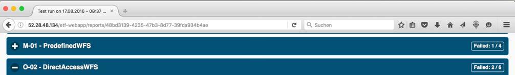
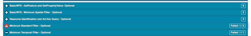
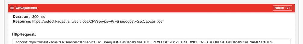
12 ETF Web Application with ELF test projects
13 Testing ELF web services SoapUI Pros: Open Source GUI for developing tests Local test execution without ETF web application supported Plugin mechanism Cons: Complex tests are memory intensive Test case can not depend on the result of a previous run test case Test case iterations not well supported Conventions and extensions required to implement helpful reports
14 ETF in the INSPIRE Validator Key extensions under development / planned to support the INSPIRE Test Framework requirements: Extend and document API (REST interface) Support for a rich domain model including Abstract Test Suites, etc. Multilingual reports Single test runs with multiple ETS which may depend on each other Dependencies between test cases, too Test driver for TeamEngine (OGC CITE tests for WFS 2.0 and GML 3.2) planned
Testing - an essential aspect of establishing an SDI
 Testing - an essential aspect of establishing an SDI Clemens Portele, Anders Östman, Michael Koutroumpas, Xin He, Janne Kovanen, Markus Schneider, Andriani Skopeliti INSPIRE Conference 2011 30 June 2011
Validation in the Netherlands and European Location Framework
 Validation in the Netherlands and European Location Framework INSPIRE Workshop on validation and conformity testing 15 16 May 2014 Thijs Brentjens Contents Geonovum and ELF INSPIRE INSPIRE in the Netherlands
European Location Framework (ELF) acting as a facilitator implementing INSPIRE
 acting as a facilitator implementing INSPIRE") www.eurogeographics.org European Location Framework (ELF) acting as a facilitator implementing INSPIRE Saulius Urbanas, Mick Cory (EuroGeographics) 29 October 2016 Copyright 2013 EuroGeographics EuroGeographics
www.eurogeographics.org European Location Framework (ELF) acting as a facilitator implementing INSPIRE Saulius Urbanas, Mick Cory (EuroGeographics) 29 October 2016 Copyright 2013 EuroGeographics EuroGeographics
Spatial Data on the Web
 Spatial Data on the Web Tools and guidance for data providers The European Commission s science and knowledge service W3C Data on the Web Best Practices 35 W3C/OGC Spatial Data on the Web Best Practices
Spatial Data on the Web
 Spatial Data on the Web Tools and guidance for data providers Clemens Portele, Andreas Zahnen, Michael Lutz, Alexander Kotsev The European Commission s science and knowledge service Joint Research Centre
INSPIRE tools What's new?
 INSPIRE tools What's new? Michael Lutz INSPIRE Conference, Antwerp 18 September 2018 Joint Research Centre The European Commission s science and knowledge service INSPIRE reference validator Why a reference
ELF + INSPIRE = LOVE STORY! ELF + INSPIRE = LOVE STORY! ELF + INSPIRE = LOVE STORY!
 www.eurogeographics.org ELF + INSPIRE = LOVE STORY! ELF + INSPIRE = LOVE STORY! ELF + INSPIRE = LOVE STORY! Schema transformation: an history of trees and tables 16 June 2014 INSPIRE conference 29 September
INSPIRE Test Framework - Design Report
 Ref. Ares(2016)6685626-29/11/2016 Joint Research Centre (JRC) INSPIRE Test Framework - Design Report Are3na Re3ference Platform Date: 02/09/2016 Doc. Version: v1.00 Commission européenne, B-1049 Bruxelles
Service metadata validation in Spatineo Monitor
 Service metadata validation in Spatineo Monitor Ilkka Rinne Spatineo Inc. INSPIRE MIG validation workshop JRC/Ispra, 15th & 16th May 2014 Spatineo Linnankoskenkatu 16 A 17 FI-00250 Helsinki +358 20 703
INSPIRE roadmap and architecture: lessons learned INSPIRE 2017
 INSPIRE roadmap and architecture: lessons learned INSPIRE 2017 Stijn Goedertier GIM Thierry Meessen GIM Jeff Konnen ACT Luxembourg Patrick Weber ACT Luxembourg 1 Administration du cadastre et de la topographie
From the INSPIRE Engine Room
 From the INSPIRE Engine Room Michael Lutz ENiiG Conference, Lisbon 9 November 2016 Joint Research Centre the European Commission's in-house science service The JRC's role in INSPIRE Support MS in implementation
Experiences with. data for use in apps
 Experiences with publishing INSPIRE data for use in apps Presentation to: Author: Date: INSPIRE Conference 2014 Clemens Portele 2014 06 18 From INSPIRE Conference 2013: "How to use INSPIRE data?" INSPIRE
ELF download services
 ELF download services Presentation to: Author: Date: ELF workshop in Moldova Marcin Grudzień 8 h September2015 14 September, 2015 Plan Introduction Specification documents The envisaged production process
INSPIRE: The ESRI Vision. Tina Hahn, GIS Consultant, ESRI(UK) Miguel Paredes, GIS Consultant, ESRI(UK)
 Miguel Paredes, GIS Consultant, ESRI(UK)") INSPIRE: The ESRI Vision Tina Hahn, GIS Consultant, ESRI(UK) Miguel Paredes, GIS Consultant, ESRI(UK) Overview Who are we? Introduction to ESRI Inc. and ESRI(UK) Presenters ArcGIS The ESRI Solution to
INSPIRE: The ESRI Vision Tina Hahn, GIS Consultant, ESRI(UK) Miguel Paredes, GIS Consultant, ESRI(UK) Overview Who are we? Introduction to ESRI Inc. and ESRI(UK) Presenters ArcGIS The ESRI Solution to
Use case 1 INSPIRE harmonization of existing Energy Performance Certificate datasets Phase 1
 The European Commission s science and knowledge service Joint Research Centre Use case 1 INSPIRE harmonization of existing Energy Performance Certificate datasets Phase 1 Giacomo Martirano (external consultant)
Introduction to INSPIRE. Network Services
 Introduction to INSPIRE. Network Services European Commission Joint Research Centre Institute for Environment and Sustainability Digital Earth and Reference Data Unit www.jrc.ec.europa.eu Serving society
Initial Operating Capability & The INSPIRE Community Geoportal
 INSPIRE Conference, Rotterdam, 15 19 June 2009 1 Infrastructure for Spatial Information in the European Community Initial Operating Capability & The INSPIRE Community Geoportal EC INSPIRE GEOPORTAL TEAM
ELF- joining Europe together
 ELF- joining Europe together An open standard based multinational web mapping project, building on INSPIRE Presentation to: ISO/TC211 Standards in Action Workshop By: Date: Jari Reini 10 th June 2015 19
Standards, standardisation & INSPIRE Status, issues, opportunities
 Standards, standardisation & INSPIRE Status, issues, opportunities INSPIRE Coordination Team 6 th MIG meeting, 13-14 June 2017 Joint Research Centre The European Commission's science and knowledge service
The European Location Framework (ELF) Project One Source for Reference Geo Information for Europe
 Project One Source for Reference Geo Information for Europe") The European Location Framework (ELF) Project One Source for Reference Geo Information for Europe Presentation to: By: Date: ICC Dresden Antti Jakobsson, Technical Coordinator 28 th August 2013 The ELF
The European Location Framework (ELF) Project One Source for Reference Geo Information for Europe Presentation to: By: Date: ICC Dresden Antti Jakobsson, Technical Coordinator 28 th August 2013 The ELF
Validation experience
 Validation experience Paloma Abad Head of SDI Department SDI Workshop 26-06-2018 INSPIRE KEN INSPIRE KEN, june 2018 1 Points 1. Introduction 2. Interoperability 3. Geoportal Thematic Viewer 4. Conclusions
INSPIRE Download Service
 The OGC SOS as INSPIRE Download Service for (meteorological) l) Observation Data Simon Jirka (52 North) 29 th October 2014 5th Workshop on the use of GIS/OGC standards in meteorology Offenbach (Germany)
ELFI: A European Location Framework
 1 ELFI: A European Location Framework 1. Our Ambition Project ELFI will foster the wider use of geo-information and enable the creation of innovative valueadded services. 2. Our Objectives We aim to create
DATA VALIDATION AGAINST SCHEMA AND SOURCE DATA
 DATA VALIDATION AGAINST SCHEMA AND SOURCE DATA didier.bouteloup@ign.fr; dominique.laurent@ign.fr 3 June 2016 ign.fr Context IGN has performed data validation twice On test INSPIRE data (2013-2014) On ELF
Web apps for INSPIRE: the ELISE Energy pilot example
 Web apps for INSPIRE: the ELISE Energy pilot example 6 September 2017 Authors: Daniele Francioli Giacomo Martirano Maria Teresa Borzacchiello Francesco Pignatelli Outline Overview of the ELISE Energy Pilot
Using the OGC SOS as INSPIRE Download Service for Observation Data
 Using the OGC SOS as INSPIRE Download Service for Observation Data Simon Jirka (52 North) Alexander Kotsev (JRC) Michael Lutz (JRC) Matthes Rieke (52 North) Robin Smith (JRC) Paul Smits (JRC) 18 th June
The cadastral data and standards based on XML in Poland
 The cadastral data and standards based on XML in Poland Jarosław Bydłosz, Piotr Parzych AGH University of Science and Technology Cracow, Poland 1 XML XML Extensible Markup Language Extensible Markup Language
News in Download services in the Czech Republic. Petr Souček Czech Office for Surveying, Mapping and Cadastre Prague, Czech Republic
 News in Download services in the Czech Republic Petr Souček Czech Office for Surveying, Mapping and Cadastre Prague, Czech Republic Topics The infrastructure The experience with themes Parcels (CP), Addresses
SDI Workshop ESDIN Best Practices INSPIRE conference, Edinburgh. Arnulf Christl, Metaspatial
 SDI Workshop ESDIN Best Practices 2011-06-28 INSPIRE conference, Edinburgh Arnulf Christl, Metaspatial Download this slide set as ODP or PDF at http://arnulf.us/publications Arnulf Christl Geospatially
AQD IPR pilot study programme on e-reporting
 AQD IPR pilot study programme on e-reporting A quick start guide working with the e-reporting schemata Tony Bush 4 th pilot meeting Copenhagen 15-16 March 2012 Introduction What to worry about first if
How to Report on Data Quality in a Multinational Environment?
 How to Report on Data Quality in a Multinational Environment? Presentation to: By: Date: SDMQ2015 Anja Hopfstock, BKG 20.01.2015 Agenda ELF architecture Data Quality Management Data Quality Reporting Summary
ELF Data Specifications
 ELF Data Specifications Presentation to: Author: Date: INSPIRE conference Anja Hopfstock (WP2), Antti Jakobsson (ELF project director) 16 th June 2014 Why extending INSPIRE? INSPIRE too much too little
Closing the INSPIRE Implementation Gap by Contributing to SDI Technology Development
 Closing the INSPIRE Implementation Gap by Contributing to SDI Technology Development Experiences from the Envibase project Lena Hallin-Pihlatie, Riikka Repo, Suvi Hatunen, Ilkka Rinne Finnish Environment
GENeric European Sustainable Information Space for Environment.
 GENeric European Sustainable Information Space for Environment http://www.genesis-fp7.eu/ Outline Introduction The GENESIS FP7 project The GENESIS solution s architecture GENESIS experience with INSPIRE
SII Law Organization Coordination activities Examples of good practices Education Technical matters Success stories Challenges
 SII Law Organization Coordination activities Examples of good practices Education Technical matters Success stories Challenges INSPIRE transposed by the legal act on Spatial Information Infrastructure
Achieving Interoperability Using Open Standards
 FedGIS Conference February 24 25, 2016 Washington, DC Achieving Interoperability Using Open Standards Satish Sankaran Marten Hogeweg Agenda Understanding Interoperability What, Why and How? ArcGIS Platform
ISA Action 1.17: A Reusable INSPIRE Reference Platform (ARE3NA)
") ISA Action 1.17: A Reusable INSPIRE Reference Platform (ARE3NA) Expert contract supporting the Study on RDF and PIDs for INSPIRE Deliverable D.EC.3.2 RDF in INSPIRE Open issues, tools, and implications
ISA Action 1.17: A Reusable INSPIRE Reference Platform (ARE3NA) Expert contract supporting the Study on RDF and PIDs for INSPIRE Deliverable D.EC.3.2 RDF in INSPIRE Open issues, tools, and implications
From Geoportal to Spatial Data Service Platform. Jani Kylmäaho National Land Survey of Finland Development Centre
 From Geoportal to Spatial Data Service Platform Jani Kylmäaho National Land Survey of Finland Development Centre Introduction National Land Survey of Finland - 1900 employees Development Centre - 120 employees
Setting up the Ihlet Social Cadastre
 Setting up the Ihlet Social Cadastre Ihlet KHT Dr. Attila Molnár, GI consultant Bela Jarolics Rome, Italy TOPICS Goal of the project Architecture Database Solution Standards, communication Metadata Security
Infrastructure for Spatial Information in Europe. Proposed action for update of MIWP: Alternative encodings for INSPIRE data
 INSPIRE Infrastructure for Spatial Information in Europe Proposed action for update of MIWP: Alternative encodings for INSPIRE data Type Creator MIWP Action fiche DG ENV Date/status/version 20/11/2017
INSPIRE Download Services of the CNIG (Spain) Emilio López Romero
 Emilio López Romero") INSPIRE Download Services of the CNIG (Spain) Emilio López Romero 1 The beginning One day, few years ago, we decided to implement INSPIRE seriously 2 The sources The first step was to identify the available
INSPIRE Download Services of the CNIG (Spain) Emilio López Romero 1 The beginning One day, few years ago, we decided to implement INSPIRE seriously 2 The sources The first step was to identify the available
Consolidation Team INSPIRE Annex I data specifications testing Call for Participation
 INSPIRE Infrastructure for Spatial Information in Europe Technical documents Consolidation Team INSPIRE Annex I data specifications testing Call for Participation Title INSPIRE Annex I data specifications
Proposed update of Technical Guidance for INSPIRE Download services based on SOS
 Proposed update of Technical Guidance for INSPIRE Download services based on SOS Organised by: Simon Jirka, Alexander Kotsev, Michael Lutz Dr. Simon Jirka (jirka@52north.org) 52 North GmbH Workshop - The
Extension of INSPIRE Download Services TG for Observation Data
 Extension of INSPIRE Download Services TG for Observation Data Simon Jirka (52 North) 14 th June 2014, MIG Workshop on WCS-based INSPIRE Download Services Agenda Motivation Sensor Web Proposed Update for
Technical implementation of INSPIRE: feed-back from experiences
 Technical implementation of INSPIRE: feed-back from experiences Lisbon 27 February 2013 1 Modèle TN-02.018-1.2 Dominique.laurent@ign.fr Plan Introduction Metadata Services Interoperability 2 Introduction
Achieving Interoperability using the ArcGIS Platform. Satish Sankaran Roberto Lucchi
 Achieving Interoperability using the ArcGIS Platform Satish Sankaran Roberto Lucchi Thank you Please fill out the session survey in your mobile app Select [Achieving Interoperability using the ArcGIS Platform]
IR on metadata Change proposal(s) on the Resource Locator element
 on the Resource Locator element") INSPIRE Infrastructure for Spatial Information in Europe IR on metadata Change proposal(s) on the Resource Locator element Type Creator Document for information and discussion CZ, DE, DK, FR, NL, ENV Date/status/version
INSPIRE Infrastructure for Spatial Information in Europe IR on metadata Change proposal(s) on the Resource Locator element Type Creator Document for information and discussion CZ, DE, DK, FR, NL, ENV Date/status/version
How to Create a European INSPIRE Compliant Data Specification. Anja Hopfstock, BKG (Germany) Morten Borrebæk, SK (Norway)
 Morten Borrebæk, SK (Norway)") How to Create a European INSPIRE Compliant Data Specification Anja Hopfstock, BKG (Germany) Morten Borrebæk, SK (Norway) ESDIN Key Goals Further the ambition of the European Commission to create a European
How to Create a European INSPIRE Compliant Data Specification Anja Hopfstock, BKG (Germany) Morten Borrebæk, SK (Norway) ESDIN Key Goals Further the ambition of the European Commission to create a European
INSPIRE & Environment Data in the EU
 INSPIRE & Environment Data in the EU Andrea Perego Research Data infrastructures for Environmental related Societal Challenges Workshop @ pre-rda P6 Workshops, Paris 22 September 2015 INSPIRE in a nutshell
The coastal data in the regional and national territorial data repertory. Genova 24 Aprile 2012 Anna Cerrato Regione Liguria
 The coastal data in the regional and national territorial data repertory Genova 24 Aprile 2012 Anna Cerrato Regione Liguria www.rndt.gov.it Experience from data providers in using transformation tools
This document is a preview generated by EVS
 TECHNICAL REPORT RAPPORT TECHNIQUE TECHNISCHER BERICHT CEN/TR 15449-5 April 2015 ICS 07.040; 35.240.70 English Version Geographic information - Spatial data infrastructures - Part 5: Validation and testing
SDI SOLUTIONS FOR INSPIRE: TECHNOLOGIES SUPPORTING A FRAMEWORK OF COOPERATION
 SDI SOLUTIONS FOR INSPIRE: TECHNOLOGIES SUPPORTING A FRAMEWORK OF COOPERATION Roberto Lucchi 1, Marten Hogeweg 1, Guenther Pichler 2 1 Esri, Redlands, CA, USA 2 Esri Kranzberg, Germany 1 Vision INSPIRE
INSPIRE compliant e-reporting under the air quality directives from a member state perspective (Belgium)
") INSPIRE compliant e-reporting under the air quality directives from a member state perspective (Belgium) Olav Peeters Belgian Interregional Environment Agency (IRCEL CELINE) Content Who are we (IRCEL CELINE)
INSPIRE compliant e-reporting under the air quality directives from a member state perspective (Belgium) Olav Peeters Belgian Interregional Environment Agency (IRCEL CELINE) Content Who are we (IRCEL CELINE)
INSPIRE Biodiversity Mashup
 INSPIRE Biodiversity Mashup Current Status 1 Kathi Schleidt Katharina.Schleidt@umweltbundesamt.at Martin Koška martin.koska@sazp.sk Peter Mozolík peter.mozolik@sazp.sk Barbara Pratschner - babsip@mac.com
Open source technologies and INSPIRE network services in Slovak environmental agency
 Open source technologies and INSPIRE network services in Slovak environmental agency Peter Mozolík, Martin Koška, Marek Žiačik, Martin Tuchyňa Slovak Environmental Agency (SEA) SEA role within slovak SDI
Rolling work programme for INSPIRE maintenance and implementation
 INSPIRE Maintenance and Implementation Group (MIG) Rolling work programme for INSPIRE maintenance and implementation Creator Michael Lutz Date of last update 2013-12-16 Subject Publisher Type Description
Draft version 13 th July Delivery manual for Article 12 data
 Delivery manual for Article 12 data Draft version 13 th July 2018 Contents 1 Introduction... 3 2 Data preparation process... 3 2.1 Overview... 3 2.2 Data validation... 4 2.3 Tabular data standards for
Landslide Damage on Chemin de Fer de la Mure near Grenoble,
 Contents 1 What is the INSPIRE directive, and why is it important?... 3 1.1 What is the aim of this document?... 4 1.2 Who will this document be useful to?... 4 2 An overview of INSPIRE specifications...
Schema transformations: From Production Database to INSPIRE data using WFS Experiences from ELF Nordic cluster
 Schema transformations: From Production Database to INSPIRE data using WFS Experiences from ELF Nordic cluster Presentation to: Author: Date: INSPIRE Schema transformation workshop Mauritz Bomark, Frank
Basic Principles of MedWIS - WISE interoperability
 Co-ordination committee seminar of the national focal points Basic Principles of MedWIS - WISE interoperability Eduardo García ADASA Sistemas Nice - France Agenda WISE vs MedWIS WISE WISE DS WISE vs WISE
Schema Transformation as a Tool for Data Reuse in Web Service Environment
 Schema Transformation as a Tool for Data Reuse in Web Service Environment Lassi Lehto Department of Geoinformatics and Cartography Finnish Geodetic Institute Masala, Finland lassi.lehto@fgi.fi Abstract
Enterprise Geographic Information Servers. Dr David Maguire Director of Products Kevin Daugherty ESRI
 Enterprise Geographic Information Servers Dr David Maguire Director of Products Kevin Daugherty ESRI Outline Introduction Enterprise GIS vs. Spatially-enabled IS Architectures for building Enterprise GIS
INSPIRE overview and possible applications for IED and E-PRTR e- Reporting Alexander Kotsev
 INSPIRE overview and possible applications for IED and E-PRTR e- Reporting Alexander Kotsev www.jrc.ec.europa.eu Serving society Stimulating innovation Supporting legislation The European data puzzle 24
Metadata - Inspire content - registration - services
 Metadata - Inspire content - registration - services Nordic Forum for Geostatistics Sept 2007 Arvid Lillethun, Norwegian Mapping and Cadaster Authority Web map service (WMS) Web feature service (WFS) Web
Implementing Quality in SDIs Introducing Building Blocks of Quality Web Services
 Implementing Quality in SDIs Introducing Building Blocks of Quality Web Services Antti Jakobsson J. Mäkelä, R. Henriksson,J. Marttinen,L. Tsoulos, I.Kavadas, E. Onstein, M. Beare,F. Williams, J. Walsh,
Application of the Catalogue and Validator tools in the context of Inspire Alberto Belussi, Jody Marca, Mauro Negri, Giuseppe Pelagatti
 Application of the Catalogue and Validator tools in the context of Inspire Alberto Belussi, Jody Marca, Mauro Negri, Giuseppe Pelagatti Politecnico di Milano giuseppe.pelagatti@polimi.it spatialdbgroup.polimi.it
Interoperability with ArcGIS
 Interoperability with ArcGIS Satish Sankaran Marten Hogeweg Agenda Understanding Interoperability What, Why and How? ArcGIS Platform An Open Platform Supporting Interoperability Examples from the real
How to become an INSPIRE node and fully exploit the investments made?
 How to become an INSPIRE node and fully exploit the investments made? Solution patterns for consumers: end users & developers (2/2) Roberto Lucchi 22 June 2010, Krakow 1 Geoportal extension Enabling discovery
Understanding and Using Metadata in ArcGIS. Adam Martin Marten Hogeweg Aleta Vienneau
 Understanding and Using Metadata in ArcGIS Adam Martin Marten Hogeweg Aleta Vienneau Adam Martin National Government Account Management R&D Open Data Marten Hogeweg National Government Professional Services
Guidelines for the encoding of spatial data
 INSPIRE Infrastructure for Spatial Information in Europe Guidelines for the encoding of spatial data Title Status Creator Date 2012-06-15 Subject Publisher Type Description Contributor Format Source Rights
e SOTER Informatics Framework Key lessons learnt
 Workshop to develop 250,000 soil database for Danube Basin using e SOTER methodology JRC, Ispra, Italy, 5 6/Feb/2015 e SOTER Informatics Framework Key lessons learnt Dr Stephen Hallett Cranfield University,
Umweltbundesamt. Masaryk University Laboratory on Geoinformatics and Cartography
 Co-funded by the community programme econtentplus GS SOIL METADATA Christian Ansorge Umweltbundesamt Tomáš Řezník Masaryk University Laboratory on Geoinformatics and Cartography GS Soil workshop, INSPIRE
The UK Marine Environmental Data and Information Network MEDIN
 The UK Marine Environmental Data and Information Network MEDIN M. Charlesworth, R. Lowry, H. Freeman, J. Rapaport, B Seeley Content MEDIN - a brief overview for context Discovery Metadata Standard and
Augmenting Thematic Maps with Data Driven Graphics by Integrating Open APIs and Mapping Platforms. Umit Dost
 Augmenting Thematic Maps with Data Driven Graphics by Integrating Open APIs and Mapping Platforms Umit Dost Agenda Background Research question Case study- PxWEB and data visualizations on Oskari Visualization
FDO Data Access Technology at a Glance
 Autodesk Geospatial FDO Data Access Technology at a Glance Work seamlessly with your geospatial data whatever the format 1 The Challenge The growing need for openness and interoperability between traditional
Notes for: Experiences with implementing interoperable WFS 2.0 services
 Notes for: Experiences with implementing interoperable WFS 2.0 services @Linking Geospatial Data 5-6 th March 2014 W3C,OGC Google Campus London Dr Tim Duffy trd@bgs.ac.uk Open source software issues Open
DanubeGIS User Manual Document number: Version: 1 Date: 11-Nov-2016
 DanubeGIS User Manual Document number: Version: 1 Date: 11-Nov-2016 Imprint Published by: ICPDR International Commission for the Protection of the Danube River ICPDR 2016 Contact ICPDR Secretariat Vienna
The AAA Model as Contribution to the Standardisation of the Geoinformation Systems in Germany
 The AAA Model as Contribution to the Standardisation of the Geoinformation Systems in Germany Markus SEIFERT, Germany Key words: ISO, CEN, OGC, AdV, Spatial Data Infrastructure SUMMARY Germany is a classic
Leveraging metadata standards in ArcGIS to support Interoperability. Aleta Vienneau and Marten Hogeweg
 Leveraging metadata standards in ArcGIS to support Interoperability Aleta Vienneau and Marten Hogeweg Leveraging metadata standards in ArcGIS to support Interoperability Overview of metadata standards
INSPIRE and Open Data Recent Developments and Best Practices
 INSPIRE and Open Data Recent Developments and Best Practices These documents are only complete, when used in connection with the verbal paper; any isolated use may lead to misunderstandings. Michael Müller
METAINFORMATION INFRASTRUCTURE FOR GEOSPATIAL INFORMATION
 2010/2 PAGES 1 7 RECEIVED 15. 6. 2009 ACCEPTED 2. 3. 2010 T. KLIMENT METAINFORMATION INFRASTRUCTURE FOR GEOSPATIAL INFORMATION ABSTRACT Tomáš KLIMENT email: tomas.kliment@stuba.sk Research field: Spatial
Rui Reis, Maria José Vale, Marcelo Ribeiro, Bruno Meneses Geospatial World Forum 2016, May 2016, Rotterdam
 LC change detection and planning indicators Rui Reis, Maria José Vale, Marcelo Ribeiro, Bruno Meneses Summary 1. 2. 3. 4. 5. 6. 7. 8. Introduction Pilot overview Data description Inspire data harmonization
Esri Support for Geospatial Standards
 APRIL 2017 ArcGIS Is Open and Interoperable Esri Support for Geospatial Standards Copyright 2017 Esri All rights reserved. Printed in the United States of America. The information contained in this document
MetOcean Themes in INSPIRE
 MetOcean Themes in INSPIRE Cliquez pour modifier le style du titre 4th Workshop on the use of GIS/OGC standards in meteorology Cliquez pour modifier le style des sous-titres Frédéric du Guillaud masque
Leveraging OGC Services in ArcGIS Server. Satish Sankaran, Esri Yingqi Tang, Esri
 Leveraging OGC Services in ArcGIS Server Satish Sankaran, Esri Yingqi Tang, Esri GIS Creating and Managing Geo Information Products - Proprietary - Open Specifications - Standards Dissemination of Geo
PRODUCT BROCHURE ERDAS APOLLO MANAGING AND SERVING GEOSPATIAL INFORMATION
 PRODUCT BROCHURE ERDAS APOLLO MANAGING AND SERVING GEOSPATIAL INFORMATION ERDAS APOLLO Do you have large volumes of geospatial information, regularly updated data stores, and a distributed user base? Do
Download Service Implementing Rule and Technical Guidance
 Download and Transformation Draft Implementing Rules Presentation for INSPIRE Initiatives Download Service Implementing Rule and Technical Guidance Olaf Østensen Statens kartverk Norwegian Mapping Authority
CREATING SMART TRANSPORT SERVICES BY FACILITATING THE RE-USE OF OPEN GIS DATA
 OPEN TRANSPORT NET TOMAS MILDORF 16 JUNE 2014 INSPIRE CONFERENCE 2014, AALBORG, DENMARK CREATING SMART TRANSPORT SERVICES BY FACILITATING THE RE-USE OF OPEN GIS DATA 2 1 OTN AT A GLANCE Full title OpenTransportNet
OGC Compliance Infrastructure
 OGC Compliance Infrastructure INSPIRE workshop on validation and conformity Ispra, Italy May 16, 2014 Luis Bermudez, Sebastian Goerke 10 Years providing compliance 300+ Copyright 2014 Open Geospatial Consortium
Suggestions for writing Abstract Test Suites (ATS) for INSPIRE conformance testing for Metadata and Network Services
 for INSPIRE conformance testing for Metadata and Network Services") Suggestions for writing Abstract Test Suites (ATS) for INSPIRE conformance testing for Metadata and Network Services MIWP-5 Workshop 02. December 2014 Sven Böhme, Federal Agency for Cartography and Geodesy
Suggestions for writing Abstract Test Suites (ATS) for INSPIRE conformance testing for Metadata and Network Services MIWP-5 Workshop 02. December 2014 Sven Böhme, Federal Agency for Cartography and Geodesy
ERDAS APOLLO Managing and Serving Geospatial Information
 ERDAS APOLLO Managing and Serving Geospatial Information ERDAS APOLLO Do you have large volumes of geospatial information, regularly updated data stores, and a distributed user base? Do you need a single,
Esri Support for Geospatial Standards: OGC and ISO/TC211. An Esri White Paper May 2015
 Esri Support for Geospatial Standards: OGC and ISO/TC211 An Esri White Paper May 2015 Copyright 2015 Esri All rights reserved. Printed in the United States of America. The information contained in this
Metadata of geographic information
 Metadata of geographic information Kai Koistinen Management of environmental data and information 4.10.2017 Topics Metadata of geographic information What is metadata? Metadata standards and recommendations
ELF extensions. Presentation to: INSPIRE MIG-T. Author: Anja Hopfstock (ELF WP2 Data Specifications) Date: 25 th February 2016.
 Date: 25 th February 2016.") ELF extensions Presentation to: Author: Date: INSPIRE MIG-T Anja Hopfstock (ELF WP2 Data Specifications) 25 th February 2016 What is ELF in connection to INSPIRE? Arrangements within NMCAs in Europe to
ELF extensions Presentation to: Author: Date: INSPIRE MIG-T Anja Hopfstock (ELF WP2 Data Specifications) 25 th February 2016 What is ELF in connection to INSPIRE? Arrangements within NMCAs in Europe to
Data quality control. Add value to Inspire services
 Data quality control Add value to Inspire services Presentation Johan Esko Project manager ISO 19157 Inspire Data management Presentation Anna Halvarsson Project manager SDI Inspire Data management 1 st
Dealing with INSPIRE complexity MIG proposal on alternative encodings
 Dealing with INSPIRE complexity MIG proposal on alternative encodings Nathalie Delattre (NGI Belgium), INSPIRE KEN Workshop, Warsaw 27-28 November 2018 Agenda 1. Basics 2. Rationales 3. MIG action 2017.2:
D Public Final Project Report
 ECP-2007-GEO-317008 ESDIN Underpinning the European Spatial Data Infrastructure with a Best Practice Network D 1.10.3 Public Final Project Report Deliverable number Dissemination level D-1.10.3 Public
Deliverable D3.12. Contract number: OJEU 2010/S Deliverable: D3.12 Author: Igor Antolovic Date: Version: Final
 Deliverable D3.12 Final and public version of the implemented web site with full functionality that hosts all relevant information on the Climate Atlas of the Carpathian Region, including a public download
INSPIRE status report
 INSPIRE Team INSPIRE Status report 29/10/2010 Page 1 of 7 INSPIRE status report Table of contents 1 INTRODUCTION... 1 2 INSPIRE STATUS... 2 2.1 BACKGROUND AND RATIONAL... 2 2.2 STAKEHOLDER PARTICIPATION...
Compass INSPIRE Services. Compass INSPIRE Services. White Paper Compass Informatics Limited Block 8, Blackrock Business
 Compass INSPIRE Services White Paper 2010 Compass INSPIRE Services Compass Informatics Limited Block 8, Blackrock Business Park, Carysfort Avenue, Blackrock, County Dublin, Ireland Contact Us: +353 1 2104580