itrail Convoy (Global) User s Manual
|
|
|
- Shavonne Carter
- 5 years ago
- Views:
Transcription
 User s")
1 itrail Convoy (Global) User s Manual 1


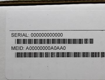
2 What s Inside 1. Wiring Harness 2. Antenna 3. itrail Convoy Base Device 4. Serial Number (Located on the box and device) 1 2 2
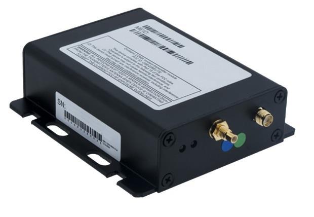
3 3 4 3

4 itrail Convoy Wiring Diagram 4
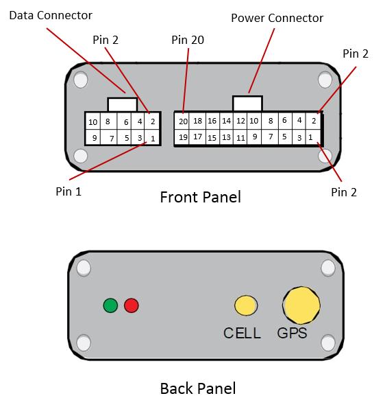
5 5
6 Getting Started With your itrail Convoy purchase, an activation fee was included in your purchase price. Please go to and click on Activate Device to sign up for a Billing account and select a Data Subscription Plan that will fit your needs. For this process, you will be signing up for two separate accounts: one for Billing and one for the Live Tracking platform. You will therefore receive two separate confirmations: one will be a confirmation stating you have created a Billing account, or that you have added a data plan to your existing account. The second will contain your Tracking account credentials. Your Tracking account is created for you by our itrail Support Team. Note: It may take hours for your Activation and the two accounts to be created. Device Installation We suggest that you take this device to a mechanic who is familiar with installing these types of devices or car stereos. They will need to make sure that it is wired correctly according to the diagram located on page 4 & 5. Proper antenna placement is necessary as well. We suggest placing the antenna inside of the plastic area of the dashboard inside the vehicle. It will be able to receive a GPS signal without interference. Make sure there is no metal surrounding or blocking the antenna and that it is not sitting on any electrical components such as the radio. After installation, your itrail Convoy may take up to 24 hours to complete the initialization process and connect to the GSM cellular network. This can take place overnight, as the device will draw power from its own backup battery and search for a signal every hour while the ignition is off. Please take the device on a test drive after that time frame to test the tracking device and to view on itrail Live tracking platform 6

7 Navigating itrail Live To log into your itrail Live tracking account, open a browser window and go to Enter your Username and Password provided to you, and click on Login. We strongly suggest you change your Password, as this default Password is not unique to your account. See page 20 for details. The itrail Live website is divided into 5 tabs: Dashboard, Tracking, Routing, Geofence, and Reports. You can find these tabs at the top of the website. Dashboard Your Group Name is along the left-hand side of the Dashboard, showing how many GPS trackers are registered under that Group. The Summary allows a user to easily see how their trackers are doing, how many alerts were sent, how many devices were in idle status, how many registered movement, and how many were stopped. You are also able to see the Average Idle Time, Average Max. Speeds, and most recent Alerts Triggered in corresponding cells on the Dashboard. 7
8 In the upper right-hand corner of the Dashboard, you can see your account name, along with a few icons. o Alerts: the bell icon is for alerts, and will have a red dot when there are unviewed alerts triggered. o Messages: the envelope icon is for the Messaging Center, which can be used to send an for itrail Support. o Gear: the Gear icon is for Favorites and Commands. o Account Name: clicking on your Account Name will allow you to log out or change your password. Alerts: The Alerts section lets you manage what kinds of alerts your device will create and how you will be notified. 1. Click on Setup Alerts under your Vehicle or Asset to get the following selection: 8

9 2. Click the Excessive Speed Selection on the Select a Trigger portion of the screen, for example. This will then change the setup values on the remaining tabs, which lets you choose when and where alerts will be sent. Select the device you would like to edit by checking the box next to it. *Please note that you will need to select the device you want the alert attached to if you have multiple devices. 3. On the Configuration and Schedule option, the Threshold is the speed limit you want to set. Select the number of days with start and end time. If you do not want constant speed alerts, you can click on Ignore Duplicates and select how many duplicated messages you want blocked. 4. On the Display Option, you can have special icons on the platform to warn you when someone is speeding. This is optional. 5. Choose what icon will appear where a Geofence alert was created using the Alert Image dropdown box. 9
10 6. Enter your or phone number, and click Save. To set up a Panic button alert, select the Panic Button from the Alert Trigger options. 1. Select if you want duplicates ignored, and continue to the Display Options. 2. On the Display Options, you can have special icons on the platform to represent your Panic alert on the map. 3. Ender your address or cell phone number, and click Save. To create a Low Battery alert. Click on Low Battery on Alert Trigger. 1. On the Configuration and Schedule option, type in the threshold, which is the battery percentage you want the device to reach before alerting you. 2. On the Display Option, you can have a special icon on the platform to represent your Battery Alert on the map. 3. Enter your address, and click Save. Tracking Tracking information is displayed using Google Earth Maps, so navigation is similar to what most people have grown used to in using internet-based mapping solutions. You can use the Navigation arrows and Zoom Bar to move around the map, or drag the map using your mouse and zoom using a click- wheel mouse. 10
11 Map Tools: Located in the upper right-hand corner of the Tracking Map. Countdown Timer: Countdown to when the tracking page refreshes and updates the map with the latest tracker location (does not affect actual GPS update frequency you selected with your data plan). Click the dropdown arrow to select a desired refresh rate. Label: Toggles GPS tracker names given to the units. POI: Toggles Points of Interest (POI) created by the user. Click the dropdown arrow to choose to see the buffer zone surrounding the POI. Geofence: Toggles visibility of created Geofences. Lock: Locks the map in place. The map won t snap back to the default position when it refreshes if it is locked. Print Map: User can print the Live or History tracking map. Included is an image of the map, along with current info on individual trackers. Export KML: The user can export the map to a KML format to open separately in Google Maps or Google Earth. Show Ruler: User can measure either distances or areas of their choosing on the map. Click the dropdown arrow to select between area and distance measurements. Map Layer: Click to choose between Google Street, Satellite, or Hybrid views of the Tracking Map. Zoom Tool: Click the + or buttons to zoom in and out of the map. Map Overview: Located in the lower right-hand corner of the Tracking Map, the Overview is a zoomed out view of the larger area the Tracking Map occupies. Click on the + or to hide this Overview Mini Map. Show/ Hide Arrows: Arrows ( < > ) to the right of the Tracking Tools on the lefthand side of the page toggle between fullscreen Tracking Tools, both Tracking Map and Tools, or fullscreen Tracking Map. Tracking Tools: Located to the left of the Tracking Map. Track Tab: Shows live map and locations of trackers. o User can filter by Group name to find specific trackers o Can also filter by other options and parameters when clicked. o List of trackers available to view. o Select or deselect to see what trackers you want. o Buttons for Session Info, Alerts, Command Messages, Ping available. 11

12 History Tab: Shows history tracking map for GPS units. o User can filter by Group name to find specific trackers o Can also filter by start date, end date, or key words. o List of trackers available to view. o Select or deselect to see what trackers you want. o Buttons for Session Info available. o When tracker trip is toggled, User can select to see alerts, show or hide trip positions, export to KML file, or can play back the trip and includes Stop, Play, Pause, FF, RW, and Speed controls for playback. o User can select specific locations on the History trip map to bring up zoomed detailed location and other session info. 12
, either in Live Tracking or History Tracking, the Session Info window")

13 Session Info: When you click on a tracker s location icon (usually green arrows), either in Live Tracking or History Tracking, the Session Info window will pop up. This will show your tracker s name, Session, Alerts triggered, Locations the tracker has been, Geofences, Live Tracker, and Status of the device. 13

14 Live Tracker: Live Tracker will open up a separate window displaying your devices locations, and allows you to see past locations. Using the drop-down boxes on the bottom right of the window, you can adjust how often your screen refreshes and how many locations will appear on the screen. The counter on the bottom left of the window displays how long it will be until your screen refreshes. You can a link to this page, allowing other users to view your tracker s location by click on the Share This icon in the upper right-hand corner of the window. When doing so, you may choose how long the link will be active before expiring using the Link Expiration dropdown 14

15 Routing The Routing tab allows you get routes and directions to specified locations from all of your trackers. This tool can be very useful, especially for fleet use with multiple service vehicles, as the map will show all of the vehicles distances and estimated travel times to a location. Map Tools: Located in the upper right-hand corner of the Route Map. Map Layer: Click to choose between Google Street, Satellite, or Hybrid views of the Tracking Map. Zoom Tool: Click the + or buttons to zoom in and out of the map. Route Tools: Located to the left of the Route map. Search: User can search for a route to a specific address or area on the map from a GPS tracker. o You can filter by Group for list of GPS trackers for a route o Either click on the map to drop a destination pin, choose a created Landmark (POI), or type in an address to generate a route. Search Directions: User can enter or click start and end points for trip directions, similar to Google Maps or Google Earth directions. 15

16 Geofence The GeoFence tab allows you to create quick Geofences, based on the location you are currently viewing or route for the device. A Geofence is a virtual barrier. The user can create a Geofence of different shapes around a specific location, and set up alerts to let them know when a tracker enters or exits that created area. Map Tools: Located in the upper right-hand corner of the Geofence Map. Search: Click the Search button to search for an address you want your Geofence to be drawn around. Clean: User can erase a drawn Geofence (before saving) if a mistake was made while drawing. Map Layers: Switch between (Street/ Satellite/ Hybrid) views. Zoom Tool: Click the + or buttons to zoom in and out of the map. 16
17 Geofence Tools: Located to the left of the Geofence Map. View Tab: o Search button used to search for an address you want your Geofence to be drawn around. Assign Tab: o Tracker List o Gear icon (next to the tracker name) to assign a Geofence to a tracker o User can search for trackers by name or filter by Group name Create Tab: o Circle Geofence 1. Click on Circle Geofence. 2. You will see a small circle around your mouse arrow. Click once on the desired location, and again away from the middle of the circle. This will create a circle around the item. o Polygon Geofence 1. Click on Polygon to create a free-form shaped Geofence. 2. Click around the desired location. Each click is an angle in your custom shape. Double click to finish drawing and close the shape. o Route Geofence 1. Click on the Route Geofence to create a boundary that will follow the entire trip of your tracker. 2. Click along the road that you plan on having your device follow. Double click to end the Geofence. o Saving your Geofence 1. Once you have created your Geofence, click save. 2. The Geofence Editor window will then pop up. Enter the name and descripton (optional). 3. You can also choose the Border and Fill color of your Geofence, along with line weight, opacity, or choose an image. 4. For a Route Geofence, enter a Route Buffer. Route Buffer is the distance in miles the tracker is allowed to stray off course before sending an alert. 5. Check the Assign to item in groups box, and use the Action dropdown box to choose if you would like an alert created when 17

18 the device enters the chosen area, exits the area, or both. 6. When you are finished, click the Save button at the bottom to save your new Geofence. Reports To run Reports on your tracking device, click on the Reports tab at the top of the screen. 18
19 My Reports: Any reports that you may have run in the past will show up under the My Reports tab. Report Templates Tab: To create a new Report, simply click on Report Templates. You can then choose a report you would like to run. When creating a report for the first time, you will have 4 options you will have to complete before running the report: 1. Columns: All columns are already pre-selected. You can click Next to continue. 2. Filters: Select the date range you want to pull data from. Select your Group, Item (Tracker), and Driver (a driver has been created). Click Next to continue. 3. Display Options: You can add either a grid or a chart to your report, or choose none of them to keep it simple. Click Next to continue. 4. Finish Report: Name your report and add a description. You will need to create a unique name (can t be named the same as default). Next, either preview your report or save and run it, and select Finish Report. Your report will open, and now show up when you first click the Reports tab from the Menu. 19
20 Changing Your Password To change your Password, click on the account name, which should appear in the upper right corner of the browser window. Once you enter your new Password, click the Change Password button to save your changes. Support To access FAQs, as well as other support materials for your device and the itrail Live Tracking platform, go to For additional support, contact itrail Support Team: Call (option 3) itrail Live support is available Monday through Friday between 8 am and 5 pm CST. 20
itrail Endurance User s Manual
 itrail Endurance User s Manual 1 What s Inside itrail Endurance device Wall Charger & Cable MEID Number (located on box and device) 2 itrail Endurance 1. Charging Port & Cover 2. LED Indicator Light 3.
Spark Nano 3.0. User s Guide WHEN YOU NEED TO KNOW.
 1 Spark Nano 3.0 User s Guide WHEN YOU NEED TO KNOW. 2 What s Inside Spark Nano Wall Charger Cellular SIM Card (Already in device)* Optional Accessories * The missing card is already installed inside of
HEAT TRACKING PLATFORM TRAINING MANUAL
 HEAT TRACKING PLATFORM TRAINING MANUAL Contents Introduction... 5 Login Page... 5 Dashboard... 6 Create Group... 7 Edit Group... 8 Group Editor... 9 In the Group Editor you can:... 9 Add New Vehicle...
Propel PRO User Guide
 Propel PRO User Guide Propel PRO Version 3.2.0a Page 1 Welcome to the latest version of Propel PRO which offers fast performance and easy navigation. Please refer to this user guide for common features
Help Guide Rev
 Help Guide Rev. 1.0 07152014 Home Page The home page displays your vehicle(s) on a satellite map. The information box, showing vehicle information will already be opened. The information box displays your
WorldTracker Enduro Users Manual
 Users Manual Contents of the Box...................... 1 Sign Up for Service...................... 2 LEDS................................... Viewing Data............................ 4 Downloading Data........................
WorldTracker Enduro Pro Users Manual
 Users Manual Contents of the Box................... 1 Sign Up for Service................... 2 LEDS............................. Viewing Data....................... 4 Downloading Data....................
GPS Asset Tracker - 3 Month Battery. User s Guide
 GPS Asset Tracker - 3 Month Battery User s Guide What s Inside 1. GPS Asset Tracker - 3 Month Battery 2. Wall Charger 3. Screwdriver Kit Optional Accessories 1 2 3 1. Charging Port 2. LED Light Indicator
Spark Nano Users Manual
 Users Manual Contents of the Box...................... 1 Sign Up for Service...................... 2 LEDS................................... Viewing Data............................ 4 Downloading Data........................
INTRODUCTION TO MIFLEET. June Support Information Robert Richey
 June 2016 Support Information fleetsales@mifleet.us fleetsupport@mifleet.us Robert Richey rrichey@dcsbusiness.com Table of Contents Basics... 3 Terms... 3 Tool tips... 3 Menu buttons... 3 Access Tab (Permissions)...
User Guide ASSET TRACKING & SECURITY LOCATE. TRACK. SECURE. CONTROL. GPS Vehicle & Asset Tracking. 24x7 Location. Security. Recovery.
 User Guide GPS Vehicle & Asset Tracking. 24x7 Location. Security. Recovery. Real-Time 24x7 Visibility GeoFence Zone Areas Events, Stops, Speeding Satellite Photo Map Multiple Vehicles View User Guide r2.4
FleetLocate v2.7 User Guide
 FleetLocate v2.7 User Guide User Guide v2.7 - FleetLocate: Fleet & Asset Intelligence Contents FleetLocate Fleet Intelligence v2.7 User Guide... 5 Map Tab... 6 Changing and Printing the Map View... 6 Bookmarks
Enter your address and password in the appropriate box then click Login. This will open the tracking system and display your assets on the map
 User Manual Logging In Go to web.fonixtelematics.com Enter your email address and password in the appropriate box then click Login This will open the tracking system and display your assets on the map
Introduction. Admin's Manual. Recommended web browsers. VehicleTracker. Welcome to VehicleTracker - the system for tracking your GPS Devices.
 Introduction VehicleTracker Admin's Manual Welcome to VehicleTracker - the system for tracking your GPS Devices. As an Administrator you can manage Operators, Event Rules and more. This manual covers both
Fleet Director Help File
 Fleet Director Help File 1 Contents 1. WELCOME TO THE FLEET DIRECTOR HELP FILE... 4 FLEET DIRECTOR COMPONENTS... 5 SYSTEM REQUIREMENTS... 7 INSTALLING MICROSOFT SILVERLIGHT... 7 LOGGING IN TO FLEET DIRECTOR...
One platform - multiple applications
 Meta Trak User Guide One platform - multiple applications www.metatrak.ie Thank you for purchasing the Metatrak GPS tracking system. We are certain that you will be delighted with the system. The product
Presentation Content
 SMS Fleet (Pty) Ltd Privately owned company established in 2006 Our product My Tracer is a locally developed, brilliant, fully internet based GPS Vehicle tracking system integrated with an innovative automated
We got your back. 1 Overview of workspace. 1.2 Top panel. Sit back and relax. Madar Tech Co. Vehicle Tracking Services.
 GSM: 91155315, 91133295 e-mail: info@madargps.com www.madargps.com Sit back and relax We got your back Madar Tech Co. Vehicle Tracking Services in Real-Time 1 Overview of workspace After login you will
Amcrest AM-GL300 GPS Tracker User Manual
 Amcrest AM-GL300 GPS Tracker User Manual Version 2.3.1 Revised August 2 nd, 2018 Contents Welcome... 4 Important Security Warning... 4 Important Safeguards and Warnings... 5 1. Introduction... 6 1.1 Features...
GPS Fleet Tracking 2.0 Change Log and Feature Release
 PRODUCT BULLETIN 1 GPS Fleet Tracking 2.0 Change Log and Feature Release Spireon Inc. is proud to announce the release of the new and improved 2.0 GPS Fleet Tracking software. This document outlines the
Full Search Map Tab Overview
 FlexMLS Map Server Full Search Map Tab Overview The Full Search Map tab is a need to know module. It is accessible when you use Full Search under Search in the Main Menu tree of FlexMLS. This map can
Full Search Map Tab. This map is the result of selecting the Map tab within Full Search.
 Full Search Map Tab This map is the result of selecting the Map tab within Full Search. This map can be used when defining your parameters starting from a Full Search. Once you have entered your desired
GpsGate VehicleTracker
 GpsGate VehicleTracker Application Manual Version: 2.1 Rev: 01 Table of Contents 1 2 3 3.1 3.2 3.2.1 3.2.2 3.2.3 3.3 3.4 3.5 3.5.1 3.5.2 3.5.3 3.5.4 3.5.5 4 4.1 4.1.1 4.1.2 4.1.3 4.2 4.3 4.4 4.4.1 4.4.2
Table of Contents. iii
 RydeSmart Help Table of Contents Welcome to RydeSmart... 7 RydeSmart Components... 7 PRISM Unit... 8 System to RydeSmart Transaction... 8 The Location Flow Transaction in Detail for Prism... 8 System
Dealer Account Request: Needed Information Admin First/Last Name Admin Address If available, list of PROSVR device IMEIs
 PROSVR Dealer Guide How Login to and get URL a PROSVR Dealer Account Dealer account requests will be sent to: mlynch@voxxintl.com Dealer Account Request: Needed Information Admin First/Last Name Admin
Revision History. Name Date Description Version Daniel Lemieux January 09, 2007 Initial Document 1.0
 Ver 1.1 Table of content 1 The Base Concepts... 5 1.1 Accessing the site... 5 1.1.1 To Access the site... 5 1.2 Environment... 6 1.2.1 Identifying the different zones within the window... 6 1.3 Closing
Ctrack Online User Guide
 Fleetstar Online A Guide to Winter Maintenance Reporting v1.1 Ctrack Online User Guide Title: Ctrack Online Quickstart Guide Date: 18/07/2013 Version: 1.0 Table of Contents 1. Ctrack Online Introduction...
Amcrest AM-GL300 GPS Tracker User Manual Version Revised December 11th, 2015
 Amcrest AM-GL300 GPS Tracker User Manual Version 1.0.1 Revised December 11th, 2015 1 Table of Contents Welcome Important Security Warning Important Safeguards and Warnings Introduction Features What s
Presentation Content
 SMS Fleet (Pty) Ltd Privately owned company established in 2006 Our product My Tracer is a locally developed, brilliant, fully internet based GPS Vehicle tracking system integrated with an innovative automated
ANWB Connect Using the Web Portal Contents
 ANWB Connect Using the Web Portal Contents Login... 2 Forgot Username... 2 Forgot Password... 3 Account Settings... 5 User Settings... 5 Edit or Delete Account Email Address... 9 Change Username... 10
End User Guide APU-s
 End User Guide APU-s Table Contents Locate 3 Maps 7 History 10 Alerts 12 Account 15 Locate The locate tab is a way to view the current status, location and information about any device you have. You will
One platform - multiple applications
 Meta Trak Lite User Guide One platform - multiple applications Enhancing productivity, protecting your vehicles Thank you for purchasing the Metatrak GPS tracking system. We are certain that you will be
Users Guide. GPS/Online Fleet Management solution to Track, Monitor and Manage your fleet.
 Users Guide GPS/Online Fleet Management solution to Track, Monitor and Manage your fleet. SolarTrak was designed by www.solar-trak.com If you have any questions, the SolarTrak Support Team is ready and
MS2. Modern Traffic Analytics ms2soft.com
 MS2 Modern Traffic Analytics ms2soft.com Updated: October 31, 2014 Table of Contents 1 Introduction 3 2 Search Types 6 3.1 Search by: Study Location 11 3.2 Search by: Crash Data 12 3.3 Search Results Page
Overview of ArcGIS Online Applications. Champaign County
 Overview of ArcGIS Online Applications Champaign County Champaign County GIS Consortium Updated: April 2017 Table of Contents ArcGIS Online Application Overview... 3 Map Interface Symbology and Terminology...
Teletrac Navman Director Quick Reference Guide
 P a g e 1 Teletrac Navman Director Quick Reference Guide http://telequip.net/pdfs/telequip_navman-director-quick-reference-guide.pdf Version 1.01 August 2016 P a g e 2 Table of Contents 1. LOG INTO NAVMAN
AT&T Fleet Center New User: Quick Start Guide
 AT&T Fleet Center New User: Quick Start Guide Getting Started: Logging In AT&T Fleet Center is a web based solution, which means there is no software to download. To login, go to fleetcenter.att.com Enter
MOBILE APP USER MANUAL
 MOBILE APP USER MANUAL available for ios / Android / Windows Phone Table of Contents 1. Motorimage Metasat Mobile App... page 3 2. Main Page... page 4 3. Commands... page 5 4. Status... page 6 5. Map...
Reset Cursor Tool Clicking on the Reset Cursor tool will clear all map and tool selections and allow tooltips to be displayed.
 SMS Featured Icons: Mapping Toolbar This document includes a brief description of some of the most commonly used tools in the SMS Desktop Software map window toolbar as well as shows you the toolbar shortcuts
Mn/DOT MnCMAT Crash Analysis Application Help
 Mn/DOT MnCMAT Crash Analysis Application Contents Login... 5 User Login Dialog... 5 Login... 5 Request Access Dialog... 5 Forgotten Password Dialog... 6 Create/Open Project... 7 Create/Open Project Dialog...
PT. PRIMANUSA GLOBALINDO PEKANBARU
 U S E R G U I D E STANDARD Fleetweb English Lite Version 1.1 July 2012 PT. PRIMANUSA GLOBALINDO PEKANBARU Revision History Date Revision Note 23 July 2012 1.0 First Release of Fleet Management User Guide
Fusion. CBR Fusion MLS Level 1 Core Functions. Class Handout
 Fusion 1 CBR Fusion MLS Level 1 Core Functions Class Handout GETTING STARTED IN FUSION Logging On and Off To log on to Fusion MLS: 1. Type your user name in the User ID box. 2. Type your password in the
Welcome To Autotrak Alert + Help Menu
 Welcome To Autotrak Alert + Help Menu Dear Valued Customer welcome to Alert+. In this document you will find an easy to follow break down of the Alert+ website and examples to help you along the way. Please
VERIFIND ONLINE USER MANUAL
 VERIFIND ONLINE USER MANUAL Table of Contents 1. Locate my asset... 2 1.1. Poll Asset via Verifind Web site.... 2 1.2. Poll Asset via SMS... 4 1.3. View movement history: Google Maps & LINZ Map.... 4 1.4.
This document describes the various enhancements and modifications to DRM Windows that occurred between versions and
 This document describes the various enhancements and modifications to DRM Windows that occurred between versions 8.3.260 and 9.1.270. New Feature: Customer Mapping The mapping feature lets you interact
Open Source Cloud Map User Guide
 Open Source Cloud Map User Guide Table of Contents Map Page... 1 Static Mercator Map... 1 Customizable Map... 1 Title Bar... 2 Toolbar... 2 Non Toolbar Navigation... 3 Map Window... 3 Layers / Legend Window...
Pub Mapping GPS and Multimedia Player Quick Start Guide
 Pub. 988-0160-461 Mapping GPS and Multimedia Player Quick Start Guide 1 Power Cable The Lowrance XOG GPS operates on an internal rechargeable battery. Battery charge is probably low at time of purchase.
User Guide for The Core
 User Guide for The Core Version 3.1 www.rock7mobile.com General Overview The Back-Office system is designed to provide a single-point of control for Iridium-based tracking devices. The system can support
New User: Quick Start Guide
 New User: Quick Start Guide Getting Started: Logging In NexTraq is a web based solution, which means there is no software to download. To login, go to http://go.nextraq.com. Enter your username and password
GpsGate VehicleTracker
 GpsGate VehicleTracker Application Manual Version: 2.3.1 Rev: 1.0 Table of Contents 1 1.1 2 2.1 2.2 2.2.1 2.3 2.3.1 2.3.2 2.3.3 2.4 2.4.1 2.4.2 2.5 2.5.1 3 3.1 3.1.1 3.1.2 3.1.3 3.2 3.3 3.4 3.4.1 3.4.2
Account Module Android and ios Wireframes
 Account Module Android and ios Wireframes 02 Account 1 2 1. Account In this section the user can see his profile, with cars linked cars and contract informations. 1.0 Background image customizable 1.1
QUICK HELP GUIDE. Traffic Signal Management System (TSMS) Modern Traffic Analytics
 Modern Traffic Analytics") QUICK HELP GUIDE Traffic Signal Management System (TSMS) Modern Traffic Analytics www.ms2soft.cotm Table of Contents 1.0 Introduction...1 2.0 Search Types...4 3.0 Map Interactions...5 4.0 Reports...8 5.0
QUICK HELP GUIDE Traffic Signal Management System (TSMS) Modern Traffic Analytics www.ms2soft.cotm Table of Contents 1.0 Introduction...1 2.0 Search Types...4 3.0 Map Interactions...5 4.0 Reports...8 5.0
 www.brightplanet.com/bluejay Table of Contents I. GETTING STARTED a) Login - Pg. 3 b) Live Map - Pg. 4 c) Manage Watchlist - Pg. 6 d) Account Settings - Pg. 8 e) Live Chat - Pg. 10 II. HOW TO GET THE MOST
Welcome To Autotrak Monitor +
 Welcome To Autotrak Monitor + Dear Valued Customer welcome to the Monitor+. Here you will find an easy to follow break down of the Monitor+ website and examples to help you along the way. Please do not
User Manual for Smart Hub Website
 Appendix to Roadway Striping Productivity Data Analysis for INDOT Greenfield and Crawfordsville Districts, SPR-3650 User Manual for Smart Hub Website 1. Login to Website Access to the GT Website is provided
My Tracer GPS Vehicle Tracking System Automated Electronic Logbook SAIAS ABSA, ATKV Cross Country Mission Statement
 Tracking & Recovery SMS Fleet (Pty) Ltd Privately owned company established in 2006 Our product My Tracer is a locally developed, brilliant, fully internet based GPS Vehicle Tracking System integrated
RITIS Training Module 4 Script
 RITIS Training Module 4 Script Welcome to the Regional Integrated Information System or RITIS Module 04 CBT. To begin, select the start button or press Shift+N on your keyboard. This training module will
City of La Crosse Online Mapping Website Help Document
 City of La Crosse Online Mapping Website Help Document This document was created to assist in using the new City of La Crosse online mapping sites. When the website is first opened, a map showing the City
GIS DATA SUBMISSION USER GUIDE. Innovation and Networks Executive Agency
 Innovation and Networks Executive Agency GIS DATA SUBMISSION USER GUIDE Innovation and Networks Executive Agency (INEA) W910 Chaussée de Wavre 910 B-1049 Brussels, Belgium Tel: +32 (0)2 29 95252 Fax: +32
IMAP MANUAL UTILITY NOTIFICATION CENTER AN INSTRUCTIONAL GUIDE TO VIEWING AND MAPPING DISTRICT POLYGONS ONLINE.
 UTILITY NOTIFICATION CENTER IMAP MANUAL AN INSTRUCTIONAL GUIDE TO VIEWING AND MAPPING DISTRICT POLYGONS ONLINE 2013 LAST UPDATE: JUNE 2013 TABLE OF CONTENTS Introduction 1 IMAP at-a-glance 2 Logging In
PacTracs 2.0 Quick Start Guide
 PacTracs 2.0 Quick Start Guide If this Quick Start Guide or the Help menu does not provide the information needed, call the Marine Exchange s 24 hour Operations Center and our watchstander will provide
Pinpoint AVM 4.0 Quick Reports Detailed User Manual
 Pinpoint AVM 4.0 Quick Reports Detailed User Manual Page 1 of 11 Table of Contents General avm navigation... 3 1 Quick Reports.... 3 Show... 4 Find... 5 Show Last X hours... 5 Show Trips Over Last 24 Hours...
ParcelQuest Quick Reference Guide
 ParcelQuest Quick Reference Guide Table of Contents BASIC SEARCHING Where is the Get Me Close search box? 3 Where is the Find My Parcels search area? 3 Where can I perform a Radius or Comp search? 4 How
Dashboard 8.0. User Guide
 Dashboard 8.0 User Guide Table of Contents Dashboard User Reference Guide Table of Contents...2 Basic Navigation...3 Content Section...3 Filter Frame...4 Table Types...5 The Drilling Process...6 The Metric
Routing a BennyBuy Access Form Using DocuSign
 Routing a BennyBuy Access Form Using DocuSign Become a DocuSign sender If you have not already done so, review the overview, signing and sending videos on the Resources/Senders page of the OSU DocuSign
Navigation NAVIGATION MANUAL 2006 TO CURRENT, PENGUINDATA WORKFORCE MANAGEMENT, INC.
 2016 Navigation NAVIGATION MANUAL 2006 TO CURRENT, PENGUINDATA WORKFORCE MANAGEMENT, INC. Version 1 16 PENGUINDATA WORKFORCE MANAGEMENT, INC. 117 Timberlane Rd, Spooner WI 54801 Table of Contents: About:...
Operation Guide. Computer Log On: Cell Phone: User Name: Password:
 Operation Guide Signing on to platform... 2 How to change my e-mail (alerts)... 2 Mapping Page Layout... 3 Change my password... 4 Change my vehicle look... 4 How to use tracks for current day... 5 How
Dealer Getting Started Guide
 Table of Contents TABLE OF CONTENTS...1 INTRODUCTION...2 UNDERSTANDING PORTALS AND LOGGING IN...2 CREATING A SUBSCRIBER...3 REGISTERING A BEACON TO A SUBSCRIBER...4 COMPLETING THE SUBSCRIBER SETUP...7
INFINITI CONNECTION FAQs
 What is Infiniti Connection? Do I need my cell phone to be able to use Infiniti Connection features? What type of connection does Infiniti Connection use? How many features does Infiniti Connection have?
Peace of Mind Solutions! TRiLOC il1000 USER GUIDE
 Peace of Mind Solutions! TRiLOC il1000 USER GUIDE Thank you and congratulations on your purchase of the TRiLOC il1000 Locator. Worn on the wrist, the il1000 incorporates the latest in GPS, 3G/2G cellular
Spidertracks Website User Guide
 Version 7.1.0 4 May 2016 Spidertracks Website User Guide For using the Spidertracks Go website and additional information. 1 Table of Contents 1. Website Architecture 2. Create a User Account 3. Creating
Guide to Mapping Website (Public) December 2016 GC_236594
 December 2016 GC_236594") Guide to Mapping Website (Public) December 2016 GC_236594 Table of Contents Guide to Mapping Website (Public)... 1 December 2016... 1 Quick Start... 3 Map Layers... 4 How do I?... 5 Draw on the Map...
Guide to Mapping Website (Public) December 2016 GC_236594 Table of Contents Guide to Mapping Website (Public)... 1 December 2016... 1 Quick Start... 3 Map Layers... 4 How do I?... 5 Draw on the Map...
TripTik Travel Planner Help
 TripTik Travel Planner Help System Requirements Browsers: Microsoft Internet Explorer version 9 or above Firefox latest version and one previous Safari latest version and one previous Google Chrome latest
YASH INFOSYSTEMS Tel: Mob: (91) ,
 ,") Date : 07 th March, 2017 PREPARED FOR: Mr. Sunil PREPARED BY: Geetanzali Arora College / University Bus Tracking Systems 1 Table Of Contents 1. Management Page No 1.1. Group 4 1.2. User 5 1.3. Device 7
Date : 07 th March, 2017 PREPARED FOR: Mr. Sunil PREPARED BY: Geetanzali Arora College / University Bus Tracking Systems 1 Table Of Contents 1. Management Page No 1.1. Group 4 1.2. User 5 1.3. Device 7
Amcrest AM-GL300 GPS Tracker User Manual Version 2.22 Revised March 3, 2016
 Amcrest AM-GL300 GPS Tracker User Manual Version 2.22 Revised March 3, 2016 1 Table of Contents Welcome... 3 Important Security Warning... 3 Important Safeguards and Warnings... 4 Introduction... 5 Features...
The Preferences link will display the following user options. These may be changed by the user at any time.
 Home Page Top Bar At the top, right-hand corner of the Home page, when logged into the Slingshot site, the user will see the name on the account, a Preferences link, and a Logout link. Preferences The
User Manual. perfectionlearning.com/technical-support
 User Manual perfectionlearning.com/technical-support 1 User Manual Accessing Math X... 3 Login... 3 Forgotten Password... 3 Navigation Menu... 4 Logout... 4 Admin... 5 Creating Classes and Students...
Press the Plus + key to zoom in. Press the Minus - key to zoom out. Scroll the mouse wheel away from you to zoom in; towards you to zoom out.
 Navigate Around the Map Interactive maps provide many choices for displaying information, searching for more details, and moving around the map. Most navigation uses the mouse, but at times you may also
For Dispatchers and Administrative Users. User Guide
 For Dispatchers and Administrative Users 800.205.7186 www.codeblue.com Table of Contents Section Page 2 Signing into Blue Alert Mobile...3 3 Blue Alert Mobile Home Screen...4 3.1 Home Screen...4 3.2 Active
Q4 Updates Include: PRODUCT UPDATE. Login using your OneView username and password.
 1 2015 Q4 Q4 Updates Include: PRODUCT UPDATE Pg.5 Pg.6 Pg.6-9 Pg.1-4 MOBILE OTHER ALARMS REPORT Report Updates Unsigned & Missing HOS Log Reports Form Reports hyperlinked to attachments HOS Violation Summary
WAIPA DISTRICT COUNCIL. Maps Online 9. Updated January This document contains an overview of IntraMaps/Maps Online version 9.
 WAIPA DISTRICT COUNCIL Maps Online 9 Updated January 2018 This document contains an overview of IntraMaps/Maps Online version 9.0 Contents Starting Maps Online... 3 Menu Bar... 4 Tools... 5 View Tab...
Banner Connected Data Solutions Web Service
 Banner Connected Data Solutions Web Service Instruction Manual Original Instructions 178337 Rev. E 14 September 2018 Banner Engineering Corp. All rights reserved 178337 Contents 1 Banner Web Services...
The Guardfreight Platform. As user s Guide. Andrew Harrison
 The Guardfreight Platform. As user s Guide. Andrew Harrison Contents Concepts... 3 Set Up... 3 Common Tasks... 4 Login... 4 Manage your user... 5 Creating New Users... 6 User Roles... 7 Setting up User
DSS User Guide. End User Guide. - i -
 DSS User Guide End User Guide - i - DSS User Guide Table of Contents End User Guide... 1 Table of Contents... 2 Part 1: Getting Started... 1 How to Log in to the Web Portal... 1 How to Manage Account Settings...
ClassHub for Teachers. A User Guide for the Classroom
 ClassHub for Teachers A User Guide for the Classroom Table of Contents CLASSHUB TEACHER... My Class Settings... Class List... Using Views and Screen Peek... Actions... MIRRORING... Mirroring Actions...
How to Save Google Maps Offline to a Mobile Phone
 How to Save Google Maps Offline to a Mobile Phone How to Download Google Maps Offline 1. Make sure your device (laptop) has an Internet connection, and sign into your Google account. 2. Open the Google
ATEK Intelligence Platform
 ATEK Intelligence Platform for Instruction Guide www.tankscan.com AIP (ATEK Intelligence Platform)... 3 Log In... 3 AIP Navigation... 4 a. Menu Tabs... 4 1. Views Menu... 4 2. Grids Menu... 4 3. Actions
GPS Kit 4.1 User Guide / Garafa.com
 GPS Kit 4.1 User Guide / Garafa.com MAPS Zooming & Panning Pinch in & out to change zoom level. Zooming is done with respect to the center of the screen. Panning is done by using one finger and dragging
GETTING A GOOD START WITH TRACKING
 Brought to you by GETTING A GOOD START WITH TRACKING User Guide www.findmyhives.com *Warning* this is a battery powered product Please Read Thank you for putting your trust in us and purchasing the T7
Introduction to Qualtrics ITSC
 Introduction to Qualtrics ITSC August 2015 Contents A. General Information... 4 B. Login... 5 New Qualtrics User... 5 Existing Qualtrics User... 7 C. Navigating Qualtrics... 9 D. Create Survey... 10 Quick
Chapter 1 : Getting Started with Integrity... Chapter 2 : Interface Layout... Chapter 3 : Navigation... Chapter 4 : Printing...
 .0 User s Manual Table of Contents Chapter : Getting Started with Integrity... Chapter : Interface Layout... Chapter : Navigation... Chapter : Printing... Chapter : Quick Search and Results Pane... Results
Edulog Parent Portal
 Edulog Parent Portal Edulog Parent Portal can be accessed via a web browser or through the mobile application. It will allow students and their parents/guardians to view the location of their bus during
ReadyTalk for HubSpot User Guide
 ReadyTalk for HubSpot User Guide Revised March 2016 2 Contents Overview... 3 Configuring ReadyTalk & HubSpot... 4 Configure Sync for Additional Webinar Data... 6 How to Setup the Sync for Additional Webinar
RITIS Training Module 9 Script
 RITIS Training Module 9 Script Welcome to the Regional Integrated Information System or RITIS Module 09 CBT. To begin, select the start button or press Shift+N on your keyboard. This training module will
LOCAL FLEET TRACKING. Quick Start Guide
 LOCAL FLEET TRACKING Quick Start Guide HOW TO SET UP THE CONTROL PANEL... 3 HOW TO SET UP A BOOKMARK... 5 HOW TO DISPLAY VEHICLE HISTORY... 7 HOW TO EDIT VEHICLE INFORMATION... 8 HOW TO CHANGE THE ACCOUNT
spidertracks instruction manual
 spidertracks instruction manual spidertracks ltd 117a the square palmerston north new zealand 4441 info@spidertracks.co.nz www.spidertracks.com P + 64 6 353 3395 October 2009. This manual was correct at
SimPoint Frequently Asked Questions
 SimPoint Frequently Asked Questions 1.0 How do I add an Optus mobile phone? 2.0 How do I upload multiple mobile units (Bulk Upload)? 3.0 How do I locate a mobile unit(s)? 4.0 How Do I Send an SMS 5.0 How
User Guide. SmartTruckRoute Android Navigation App for Truck Drivers. Introduction: Installation - Activation
 User Guide SmartTruckRoute Android Navigation App for Truck Drivers Introduction: Installation - Activation Download SmartTruckRoute from Google Play. Use the app free of charge from 1-2 PM and 1-2 AM
TABLE OF CONTENTS 1 INTRO
 TABLE OF CONTENTS 1 INTRO 4 2 GETTING STARTED 5 2.1 CREATING AN ACCOUNT 2.1.1 ENTERING ACCOUNT INFORMATION 2.1.2 SELECTING A PLAN 2.1.3 ENTERING PAYMENT INFORMATION 2.1.4 REVIEW AND CONFIRM 2.2 LOGGING
TactiTrack GPS Tracking Software
 1 The interface Dropdown list with all your GPS trackers Search for a tracker in your account Status of your GPS tracker (On / Off / Sleeping ) GPS Signal strength Battery level of your GPS tracker Speed