Mobile Mapping The StreetMapper Approach. Andrew Fuller LiDAR Systems Engineer
|
|
|
- Ethan Cox
- 6 years ago
- Views:
Transcription

1 Mobile Mapping The StreetMapper Approach Andrew Fuller LiDAR Systems Engineer

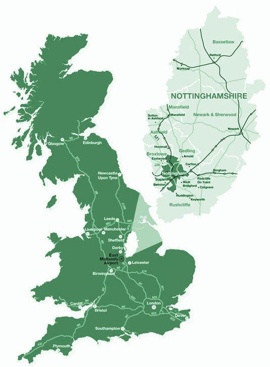
2 UK company based in Nottingham

3 Global 3D Laser Mapping Solutions Innovative solutions StreetMapper Over 11 years experience 3D Scanning Solutions Global technical support LiteMapper & Terrasolid SiteMonitor for Mine Surveying
4 Why 3D Laser Mapping? 1. Most experienced company in mobile mapping market 11 years (3DLM) plus 27 years (IGI) 2. World s first commercially available mobile laser system First demonstrator: May First class technical support High customer satisfaction and repeat business 4. Market leader in mobile mapping systems
5 Why use Mobile Mapping? 10 sq km/hr Airborne LIDAR Speed of data capture 3D Scanners 0.1 sq km/hr 100k Capital cost 600k
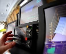
6 What is StreetMapper?

 Mount StreetMapper offers flexibility in")
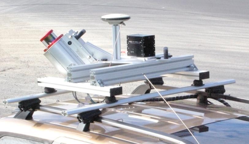
7 What is a mobile mapping system? GPS antenna IMU Laser scanner Laser scanner GPS/INS & Power supply Control PC Camera (one behind each scanner) Mount StreetMapper offers flexibility in selecting mounts Camera PC

8 Sensors: Laser scanners One or two laser scanners: 360 field of view 2D laser scanners 300 khz measurement rate 300m maximum range 5mm range accuracy Calibrated reflectivity Multiple return pulses


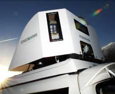
9 StreetMapper 360 Mount Lifting platform Safety of staff + security + environmental protection
10 StreetMapper Portable Mount Can be easily relocated around the world

11 New innovation POD housing Covers external equipment and protects: Improved water resistance - to IP65 standard. Improved resistance to dust ingress. Improved heat resilience. Operational range -10 to +40 degrees Celsius
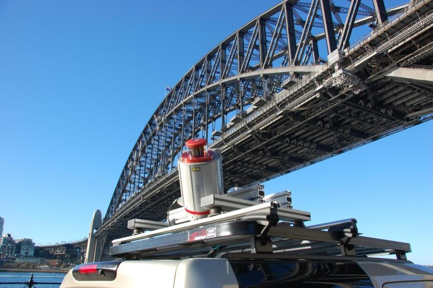
12 What data does StreetMapper produce? Point Data + Images CAD/GIS software Feature extraction software Coloured Point Data Vector map/survey data Rapid 3D visualisation Asset database Situational awareness (military intelligence)

13 Lisbon Tunnel Colour & CAD
14 Mobile Mapping Capability

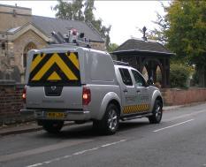
15 By Land: Highways, Buildings, Cities StreetMapper 360 map anywhere a vehicle can go!

16 Dutch Business park with colour.


17 By Rail: Vehicle adapted for railway

18 Australian Rail project

19 Helsinki Tram project


20 By Water: Portable system on a boat


21 By Air: Portable system on a helicopter

22 Cape Town Coastline
23 Typical Data Capture Rates


 Project delivered")
24 Urban Projects Typical UK Estimation 4K EUR 15Km of urban streets: Data capture: 2 Hours Point processing: 10 Hours (1:5) Project delivered in 3 man-days.

 Project delivered in 7")
25 Large Scale 78 areas approx 5km each Area 001 of 078 Worldwide Ballpark 50K EUR Approx 400Km of urban streets: Data capture: 8 days Point processing: 40 days (1:5) Project delivered in 7 weeks.

26 Why StreetMapper? 1. Highest accuracy 2. Most flexible system: 1. Lifting platform 2. Portable system 3. Ease of use 4. Highest performance sensors & navigation 5. European export controlled navigation system usually takes only 4 weeks to arrange export

27 Work Flow and Software SMProcess: Controls all software functions
28 StreetMapper Users Geomaat, Netherlands: Highways survey Tecdawn, China: Highways survey and city model Geokosmos, Russia: Highways survey National University of Ireland: Research General Dynamics: Rapid mapping (military uses) Terrametrix, USA Highways survey Geodigital, Canada: Highways survey Halcrow, UK: Highways survey GloMapTech, South Africa: Highways survey TKTI, Lithuania: Highways Survey
29 StreetMapper Users
30 StreetMapper Projects
31 How does StreetMapper work?
, Universität")

32 City Model Accuracy Tests - Stuttgart Undertaken by Institute for Photogrammetry (ifp), Universität Stuttgart, Germany Compare to 3D model of City Surveying Office of Stuttgart 35 minutes surveying 18km survey


33 Navigation Accuracy Number of satellites along the route Estimated horizontal accuracy along the route


34 Point Cloud Accuracy Compare points with 3D model for each façade Comparison made in good and bad GPS areas Overall RMS error 3cm or better from model to points
 lane highway in San Diego number of Control Points 1567 average dz 0.")
35 Highway Accuracy Tests - CALTRANS Undertaken by Terrametrix Caltrans Mobile Mapping Test Area Half-mile stretch of High Occupancy Vehicle (HOV) lane highway in San Diego number of Control Points 1567 average dz 0.9mm minimum dz -15mm maximum dz +18mm root mean square 7mm
36 What can I do with StreetMapper?

37 Highway Junctions Using TerraScan within MicroStation

38 Plan view of points and elements
39 Generation of 3D virtual worlds

40 Typical Applications Accident Reconstruction

41 Typical Applications Urban Mapping High resolution flood mapping
42 Typical Applications Overhead Wire Surveys

43 Typical Applications High-load Route Planning


44 Typical Applications Coastal Surveys Docks and Harbours

45 Dover docks
46 Thank You Any questions? 3D Laser Mapping Ltd. Unit 1, Moorbridge Court Moorbridge Road East Bingham, Nottingham NG13 8GG, UK T: +44 (0) F: +44 (0) E: W: IGI mbh Langenauer Str Kreuztal Germany T: F: E: W:
StreetMapper 360 & StreetMapper Portable
 StreetMapper 360 & StreetMapper Portable 11th February 2010 Dr. Chris Cox & Mr. Olaf Gross 3D Laser Mapping LIDAR Specialists StreetMapper Distributor for RIEGL (UK, Ireland, Southern Africa) Terrasolid
THE RAILMAPPER - A DEDICATED MOBILE LIDAR MAPPING SYSTEM FOR RAILWAY NETWORKS
 THE RAILMAPPER - A DEDICATED MOBILE LIDAR MAPPING SYSTEM FOR RAILWAY NETWORKS Jens Kremer & Albrecht Grimm IGI mbh, Langenauer Straße 46, 57223 Kreuztal, Germany (j.kremer, a.grimm)@igi-systems.com ICWG
Smart Systems for Aerial Survey & Mobile Mapping
 Moscow, Feb. 2013 NEWS from IGI Smart Systems for Aerial Survey & Mobile Mapping Christian Grimm IGI, 57223 Kreuztal / Germany IGI mbh Langenauer Str. 46 57223 Kreuztal, Germany www.igi.eu www.litemapper.eu
 Die im Vortrag gezeigten Video Clips können unter http://www.streetmapper.net/gallery/animations.htm heruntergeladen werden. Stuttgart, 19. Juni 2007 Mobile Mapping - 3D-Datenerfassung kommt in Fahrt Jens
Mobile LiDAR for Ground Applications. Spar 2006, March Paul Mrstik, Terrapoint Canada Inc. Craig Glennie, Terrapoint USA LLC
 Mobile LiDAR for Ground Applications Spar 2006, March 27 2006 Paul Mrstik, Terrapoint Canada Inc. Craig Glennie, Terrapoint USA LLC Agenda Introduction to Terrapoint What is mobile LiDAR? Advantages of
SPAR, ELMF 2013, Amsterdam. Laser Scanning on the UK Highways Agency Network. Hamish Grierson Blom Uk
 SPAR, ELMF 2013, Amsterdam Laser Scanning on the UK Highways Agency Network Hamish Grierson Blom Uk www.blomasa.com www.blom-uk.co.uk Blom UK Part of the Blom Group Blom Group - Europe s largest aerial
MONITORING COASTAL INSTABILITY USING AIRBORNE AND TERRESTRIAL LIDAR
 MONITORING COASTAL INSTABILITY USING AIRBORNE AND TERRESTRIAL LIDAR A Coastal Challenge Monitoring coastlines is a challenging task, especially due to the typically inaccessible nature of the coastal terrain.
GNSS/INS for High Accuracy Mobile Mapping. Olaf Gross 11 th Terrasolid European User Event Kittilä, Finland
 GNSS/INS for High Accuracy Mobile Mapping Olaf Gross 11 th Terrasolid European User Event 15.02.2012 Kittilä, Finland IGI mbh Founded 1978 25 staff about half in R&D More than 380 customers in 60 different
2-4 April 2019 Taets Art and Event Park, Amsterdam CLICK TO KNOW MORE
 Co-Host Host 2-4 April 2019 Taets Art and Event Park, Amsterdam CLICK TO KNOW MORE Presentation Outline review modern survey methodologies available to support railway requirements measuring everything
Trimble Mobile Mapping Portfolio
 Jörg Amend Sales Account Manager SEPTEMBER 20 2017 Trimble Mobile Mapping Portfolio Current challenges and trends Multible Sensors connecting to one Echosystem Trimble RealWorks Trimble Edgewise TBC Pathfinder
3D Data Acquisition in Tunnels Optimizing Track Time Using Terrestrial Mobile LiDAR. Scanning. Michael R. Frecks, PLS.
 3D Data Acquisition in Tunnels Optimizing Track Time Using Terrestrial Mobile LiDAR Scanning Michael R. Frecks, PLS President/CEO AREMA 2013 1207 Understanding mobile 3D LiDAR? light detection and ranging
Federica Zampa Sineco SpA V. le Isonzo, 14/1, Milan, 20135, Italy
 LYNX MOBILE MAPPER TM : THE NEW SURVEY TECHNOLOGY Federica Zampa Sineco SpA V. le Isonzo, 14/1, Milan, 20135, Italy federica.zampa@sineco.co.it Dario Conforti Optech Incorporated 300 Interchange Way, Vaughan,
Trimble GeoSpatial Products
 Expanding Solutions for Photogrammetric and Remote Sensing Professionals 55 th Photogrammetric Week in Stuttgart September 7 th 2015 Tobias Heuchel, Trimble Stuttgart, Germany Trimble GeoSpatial Products
GeoSLAM Overview. The global leader in go anywhere 3D mobile mapping technology. 1
 GeoSLAM Overview The global leader in go anywhere 3D mobile mapping technology. 1 About GeoSLAM The global leader in go anywhere 3D mobile mapping technology. 2 Who We Are GeoSLAM is a global market leader
GeoSLAM Overview. The experts in go-anywhere 3D mobile mapping technology
 GeoSLAM Overview The experts in go-anywhere 3D mobile mapping technology 1 About GeoSLAM The experts in go-anywhere 3D mobile mapping technology 2 Who We Are GeoSLAM is a global market leader in go-anywhere
Geospatial Engineering Problems & Solutions Associated With NDP Roads, Tunnelling & Civil Engineering Projects Use of HDS Leica Laser Scanners
 Geospatial Engineering Problems & Solutions Associated With NDP Roads, Tunnelling & Civil Engineering Projects Use of HDS Leica Laser Scanners Laser Scanning Laser Scanning is a method of collecting large
MANY DISCOVER THE BENEFITS OF 3D MEASUREMENT TECHNOLOGY IN LONDON
 MANY DISCOVER THE BENEFITS OF 3D MEASUREMENT TECHNOLOGY IN LONDON Last week UK delegates were shown the benefits and uses of 3D measurement systems and software at a free event held by 3D Laser Mapping,
Overview of the Trimble TX5 Laser Scanner
 Overview of the Trimble TX5 Laser Scanner Trimble TX5 Revolutionary and versatile scanning solution Compact / Lightweight Efficient Economical Ease of Use Small and Compact Smallest and most compact 3D
An Overview of Applanix.
 An Overview of Applanix The Company The Industry Leader in Developing Aided Inertial Technology Founded on Canadian Aerospace and Defense Industry Expertise Providing Precise Position and Orientation Systems
NEW APPROACH FOR SAFE, FAST AND ACCURATE SURVEY OF DEEP MINE SHAFTS
 NEW APPROACH FOR SAFE, FAST AND ACCURATE SURVEY OF DEEP MINE SHAFTS by Norbert Benecke & Peter Cain DMT GmbH &Co. KG, Germany / DMT Geosciences, Canada Kinemattic Shaft Survey 2013 Page 1 Who is DMT? is
3D Laser Scanning Technology. Fast, Safe, Accurate. Rugged hardware and powerful software combined with streamlined survey workflow
 3D Laser Scanning Technology Fast, Safe, Accurate Rugged hardware and powerful software combined with streamlined survey workflow Maptek specialises in the research, development and application of 3D laser
Aerial and Mobile LiDAR Data Fusion
 Creating Value Delivering Solutions Aerial and Mobile LiDAR Data Fusion Dr. Srini Dharmapuri, CP, PMP What You Will Learn About LiDAR Fusion Mobile and Aerial LiDAR Technology Components & Parameters Project
LANDINS Georeferencing and Orientation System
 LANDINS Georeferencing and Orientation System LANDINS Georeferencing and Orientation System Landins is a simple, turnkey position and orientation system for land-based mobile applications. It offers dependable
InteLAS Family of Mobile LiDAR Systems
 InteLAS Family of Mobile LiDAR Systems September 2015 What we do ilinks Geosolutions LLC Hydrographic surveying and seabed modeling Topographic surveying and mobile mapping Systems engineering and integration
Airborne Laser Survey Systems: Technology and Applications
 Abstract Airborne Laser Survey Systems: Technology and Applications Guangping HE Lambda Tech International, Inc. 2323B Blue Mound RD., Waukesha, WI-53186, USA Email: he@lambdatech.com As mapping products
Pattern Recognition for Autonomous. Pattern Recognition for Autonomous. Driving. Freie Universität t Berlin. Raul Rojas
 Pattern Recognition for Autonomous Pattern Recognition for Autonomous Driving Raul Rojas Freie Universität t Berlin FU Berlin Berlin 3d model from Berlin Partner Freie Universitaet Berlin Outline of the
Corridor Survey of Both Existing and New to be Built Pipelines on Land Using LiDAR Scanning
 Corridor Survey of Both Existing and New to be Built Pipelines on Land Using LiDAR Scanning 1. Introduction For good monitoring and planning an onshore pipeline and to feed the Geographic Information System,
ROAD SURFACE STRUCTURE MONITORING AND ANALYSIS USING HIGH PRECISION GPS MOBILE MEASUREMENT SYSTEMS (MMS)
") ROAD SURFACE STRUCTURE MONITORING AND ANALYSIS USING HIGH PRECISION GPS MOBILE MEASUREMENT SYSTEMS (MMS) Bonifacio R. Prieto PASCO Philippines Corporation, Pasig City, 1605, Philippines Email: bonifacio_prieto@pascoph.com
ROAD SURFACE STRUCTURE MONITORING AND ANALYSIS USING HIGH PRECISION GPS MOBILE MEASUREMENT SYSTEMS (MMS) Bonifacio R. Prieto PASCO Philippines Corporation, Pasig City, 1605, Philippines Email: bonifacio_prieto@pascoph.com
Leica Geosystems Regional Public Safety Conference. Joshua Rayburn Consolidated Forensic Laboratory, Washington DC Present Date:
 Leica Geosystems Regional Public Safety Conference Joshua Rayburn Consolidated Forensic Laboratory, Washington DC Present Date: 04.15.15 2 What is a Pegasus? Portable survey-grade mobile mapping solution
Virtually Real: Terrestrial Laser Scanning
 Check. They re Chartered. Geomatics Client Guides Virtually Real: Terrestrial Laser Scanning Understanding an evolving survey technology Summary This guide gives you an overview of the technique, some
Sensor Fusion: Potential, Challenges and Applications. Presented by KVH Industries and Geodetics, Inc. December 2016
 Sensor Fusion: Potential, Challenges and Applications Presented by KVH Industries and Geodetics, Inc. December 2016 1 KVH Industries Overview Innovative technology company 600 employees worldwide Focused
IP-S2 HD. High Definition 3D Mobile Mapping System
 IP-S2 HD High Definition 3D Mobile Mapping System Integrated, turnkey solution Georeferenced, Time-Stamped, Point Clouds and Imagery High Density, Long Range LiDAR sensor for ultimate in visual detail
Integrated Multi-Source LiDAR and Imagery
 Figure 1: AirDaC aerial scanning system Integrated Multi-Source LiDAR and Imagery The derived benefits of LiDAR scanning in the fields of engineering, surveying, and planning are well documented. It has
LiDAR & Orthophoto Data Report
 LiDAR & Orthophoto Data Report Tofino Flood Plain Mapping Data collected and prepared for: District of Tofino, BC 121 3 rd Street Tofino, BC V0R 2Z0 Eagle Mapping Ltd. #201 2071 Kingsway Ave Port Coquitlam,
A New Way to Control Mobile LiDAR Data
 A New Way to Control Mobile LiDAR Data Survey control has always been a critically important issue when conducting mobile LiDAR surveys. While the accuracies currently being achieved with the most capable
THE RANGER-UAV FEATURES
 THE RANGER-UAV The Ranger Series Ranger-UAV is designed for the most demanding mapping applications, no compromises made. With a 9 meter laser range, this system produces photorealistic 3D point clouds
LiDAR Drone. Land Profile to Your Desktop. Processing. for LiDAR data processing, point cloud vectorization, classification and more
 LiDAR Drone Processing Outsource to us for LiDAR data processing, point cloud vectorization, classification and more Goodland Surveys Pvt Ltd # # # Mobile/Airbone LiDAR Processing & Conversion Geo Spatial
Quality Assurance and Quality Control Procedures for Survey-Grade Mobile Mapping Systems
 Quality Assurance and Quality Control Procedures for Survey-Grade Mobile Mapping Systems Latin America Geospatial Forum November, 2015 Agenda 1. Who is Teledyne Optech 2. The Lynx Mobile Mapper 3. Mobile
LaserFleX New Generation of High Performance Infrastructure Measurement System
 Balfour Beatty Rail LaserFleX New Generation of High Performance Infrastructure Measurement System LaserFleX TM Introduction LaserFleX TM is the modular railway infrastructure and track measurement system
Trimble VISION Positions from Pictures
 Trimble VISION Positions from Pictures This session will cover What Is Trimble VISION? Trimble VISION Portfolio What Do you Need? How Does It Work & How Accurate Is It? Applications Resources Trimble VISION
Terrestrial Laser Scanning: Applications in Civil Engineering Pauline Miller
 Terrestrial Laser Scanning: Applications in Civil Engineering Pauline Miller School of Civil Engineering & Geosciences Newcastle University Overview Laser scanning overview Research applications geometric
Case studies about using Mobile Mapping System (MMS) on traffic network mapping
 on traffic network mapping") HUNGARIAN GEODETIC AND MAPPING CORPORATION LTD. Case studies about using Mobile Mapping System (MMS) on traffic network mapping Peter Csörgits Chief Engineer Hungarian Geodetic and Mapping co. Ltd. What
HUNGARIAN GEODETIC AND MAPPING CORPORATION LTD. Case studies about using Mobile Mapping System (MMS) on traffic network mapping Peter Csörgits Chief Engineer Hungarian Geodetic and Mapping co. Ltd. What
IP-S2 HD HD IP-S2. 3D Mobile Mapping System. 3D Mobile Mapping System
 HD HD 3D Mobile Mapping System 3D Mobile Mapping System Capture Geo-referenced, Time-Stamped Point Clouds and Imagery 3D Scanning of Roadside Features 360º Camera for Spherical Image Capture Dual Frequency
ROAD-SCANNER COMPACT APPLICATION FIELDS MAIN FEATURES
 ROAD-SCANNER COMPACT Mobile Mapping System by GEXCEL & SITECO collaboration A smaller mobile system for asset management and cartography suited for ZOLLER & FRÖHLICH PROFILER 9012 laser scanner. 2 + 3
POINT CLOUD ANALYSIS FOR ROAD PAVEMENTS IN BAD CONDITIONS INTRODUCTION
 POINT CLOUD ANALYSIS FOR ROAD PAVEMENTS IN BAD CONDITIONS Yoshiyuki Yamamoto, Associate Professor Yasuhiro Shimizu, Doctoral Student Eiji Nakamura, Professor Masayuki Okugawa, Associate Professor Aichi
Pathway Services Inc. Technology Presentation
 Lauren Tran Budapest, Hungary 2015 Largest Vendor of this kind in the U.S. Largest Fleet of Full Service Vehicles in U.S. (26) More Than 5 Million Kilometers Collected Using Our Equipment Nearly 50% of
A New Direction in GIS Data Collection or Why Are You Still in the Field?
 GeoAutomation The Mobile Mapping System Survey-Enabled Imagery A New Direction in GIS Data Collection or Why Are You Still in the Field? Presentation to: URISA BC GIS Technology Showcase January 19, 2011
Bringing Singapore to life in 3D
 Bringing Singapore to life in 3D Dr Victor Khoo, Deputy Director Singapore Land Authority Bringing Singapore to life in 3D ESRI Singapore UC 2016 Dr. Victor Khoo Singapore Land Authority SLA 2016 RESTRICTED
LiDAR improves railroad maintenance and safety
 www.terrasolid.com LiDAR improves railroad maintenance and safety Kjell Tuominen 16.10 2018 Current maintenance and safety problems The maintenance tenders are based on incomplete information The accuracy
AIRBORNE GEIGER MODE LIDAR - LATEST ADVANCEMENTS IN REMOTE SENSING APPLICATIONS RANDY RHOADS
 Place image here (10 x 3.5 ) AIRBORNE GEIGER MODE LIDAR - LATEST ADVANCEMENTS IN REMOTE SENSING APPLICATIONS RANDY RHOADS Geospatial Industry Manager HARRIS.COM #HARRISCORP Harris Company Information SECURITY
Recent developments in laser scanning
 Recent developments in laser scanning Kourosh Khoshelham With contributions from: Sander Oude Elberink, Guorui Li, Xinwei Fang, Sudan Xu and Lucia Diaz Vilarino Why laser scanning? Laser scanning accurate
Innovation in 3D. Product Overview
 Innovation in 3D Product Overview TERRESTRIAL LASER SCANNING VQ-1560i MULTIPLE-TIME- AROUND-PROCESSING VZ-400i ECHO DIGITIZATION AIRBORNE LASER SCANNING VUX-1UAV HIGHLY ACCURATE EFFICIENT LIGHTWEIGHT RiCOPTER
Aided-inertial for GPS-denied Navigation and Mapping
 Aided-inertial for GPS-denied Navigation and Mapping Erik Lithopoulos Applanix Corporation 85 Leek Crescent, Richmond Ontario, Canada L4B 3B3 elithopoulos@applanix.com ABSTRACT This paper describes the
Trimble MX2 mobile mapping
 Trimble MX2 mobile mapping user applications Point clouds within your reach The Trimble MX2 is a vehicle-mounted spatial imaging system which combines high resolution laser scanning and panoramic cameras
ENY-C2005 Geoinformation in Environmental Modeling Lecture 4b: Laser scanning
 1 ENY-C2005 Geoinformation in Environmental Modeling Lecture 4b: Laser scanning Petri Rönnholm Aalto University 2 Learning objectives To recognize applications of laser scanning To understand principles
Boresight alignment method for mobile laser scanning systems
 Boresight alignment method for mobile laser scanning systems P. Rieger, N. Studnicka, M. Pfennigbauer RIEGL Laser Measurement Systems GmbH A-3580 Horn, Austria Contents A new principle of boresight alignment
High Resolution Laserscanning, not only for 3D-City Models
 Lohr 133 High Resolution Laserscanning, not only for 3D-City Models UWE LOHR, Ravensburg ABSTRACT The TopoSys laserscanner system is designed to produce digital elevation models (DEMs) of the environment
1. Introduction. A CASE STUDY Dense Image Matching Using Oblique Imagery Towards All-in- One Photogrammetry
 Submitted to GIM International FEATURE A CASE STUDY Dense Image Matching Using Oblique Imagery Towards All-in- One Photogrammetry Dieter Fritsch 1, Jens Kremer 2, Albrecht Grimm 2, Mathias Rothermel 1
Mobile Laser Scanning Technology for Surveying Application: From Data Collection to End-Products
 Mobile Laser Scanning Technology for Surveying Application: From Data Collection to End-Products Valerie USSYSHKIN, Canada Key words: laser scanning, remote sensing, professional practice, mobile lidar;
ALS40 Airborne Laser Scanner
 ALS40 Airborne Laser Scanner Airborne LIDAR for Professionals High Performance Laser Scanning Direct Measurement of Ground Surface from the Air The ALS40 Airborne Laser Scanner measures the topography
Leica ALS70. Airborne Laser Scanners Performance for diverse Applications
 Leica ALS70 Airborne Laser Scanners Performance for diverse Applications Three Models, One Result. Highest Productivity in all Applications. Imagine an affordable 500 khz pulse rate city-mapping LIDAR
Introducing the Garmin nüvi 42LM Essential GPS Navigator
 Introducing the Garmin nüvi 42LM Essential GPS Navigator Package Content Suction Cup Mount USB Cable Vehicle Power Cable nüvi 42LM Quick Start Manual P3 E&OE March 2013 FREE Lifetime Map Updates The nüvi
Building the Future. New ICT Enables Smart Cities. Yannis Liapis Oct 25 th,
 Building the Future New ICT Enables Smart Cities Yannis Liapis Oct 25 th, 2017 1 Why Do We Need Smart City? Rapid population growth, urbanization acceleration Major issues Global population growth will
Merlin vessel-based lidar system
 Brochure: Merlin vessel-based lidar system Merlin vessel-based lidar system Map the full environment in one pass Scanning the full marine environment in a single operation reduces the amount of time crew
Creating Value. Delivering Solutions
 Creating Value Delivering Solutions LIDAR...Light Detection and Ranging Technology from the military (1960 s) Rapid, highly accurate DEM coverage of large to medium sized project areas Feature extraction
LiDAR data pre-processing for Ghanaian forests biomass estimation. Arbonaut, REDD+ Unit, Joensuu, Finland
 LiDAR data pre-processing for Ghanaian forests biomass estimation Arbonaut, REDD+ Unit, Joensuu, Finland Airborne Laser Scanning principle Objectives of the research Prepare the laser scanning data for
The Applanix Approach to GPS/INS Integration
 Lithopoulos 53 The Applanix Approach to GPS/INS Integration ERIK LITHOPOULOS, Markham ABSTRACT The Position and Orientation System for Direct Georeferencing (POS/DG) is an off-the-shelf integrated GPS/inertial
Trimble Geospatial Division Integrated Solutions for Geomatics professions. Volker Zirn Regional Sales Representative
 Trimble Geospatial Division Integrated Solutions for Geomatics professions Volker Zirn Regional Sales Representative 1 Agenda Trimble GeoSpatial Division Airborne System Solutions Trimble Inpho Software
LiDAR data overview. Dr. Keiko Saito Global Facility for Disaster Reduction and Recovery (GFDRR)
") LiDAR data overview Dr. Keiko Saito Global Facility for Disaster Reduction and Recovery (GFDRR) LiDAR (Light Detecting And Ranging) 3D height profile Laser emitted from sensor onboard aircraft to measure
LiDAR data overview Dr. Keiko Saito Global Facility for Disaster Reduction and Recovery (GFDRR) LiDAR (Light Detecting And Ranging) 3D height profile Laser emitted from sensor onboard aircraft to measure
TopoDrone Photogrammetric Mapping Reliable, Accurate, Safe
 TopoDrone Photogrammetric Mapping Reliable, Accurate, Safe A complete solution for accurate airborne data capture and photogrammetric mapping using an unmanned aerial vehicle COST EFFICIENT SOLUTION TO
Merging LiDAR Data with Softcopy Photogrammetry Data
 Merging LiDAR Data with Softcopy Photogrammetry Data Cindy McCallum WisDOT\Bureau of Technical Services Surveying & Mapping Section Photogrammetry Unit Overview Terms and processes Why use data from LiDAR
HIGH-DEFINITION SURVEY AND BIM PRESENTATION FOR BIM-MEP AUS
 www.aamgroup.com/bim HIGH-DEFINITION SURVEY AND BIM PRESENTATION FOR BIM-MEP AUS Matt Rumbelow, B.Arch AAM BIM Coordinator ABOUT AAM Reality Captured. Certainty Delivered Reality Captured. Certainty Delivered
WIRELESS CCTV. Mobile Surveillance for Events.
 WIRELESS CCTV Mobile Surveillance for Events Wireless CCTV Wireless CCTV (WCCTV) is a market leading, customer focussed provider of portable, re-deployable mobile surveillance solutions. WCCTV manufactures
The Most Comprehensive Solution for Indoor Mapping Applications
 The Most Comprehensive Solution for Indoor Mapping Applications TRIMBLE INDOOR MOBILE MAPPING SOLUTION TRIMBLE INDOOR MOBILE MAPPING SOLUTION (TIMMS): HIGH EFFICIENCY, MAXIMUM FLEXIBILITY, ALL-IN-ONE PACKAGE
GPS-Aided Inertial Navigation Systems (INS) for Remote Sensing
 for Remote Sensing") GPS-Aided Inertial Navigation Systems (INS) for Remote Sensing www.inertiallabs.com 1 EVOLUTION OF REMOTE SENSING The latest progress in Remote sensing emerged more than 150 years ago, as balloonists took
GPS-Aided Inertial Navigation Systems (INS) for Remote Sensing www.inertiallabs.com 1 EVOLUTION OF REMOTE SENSING The latest progress in Remote sensing emerged more than 150 years ago, as balloonists took
Terrestrial GPS setup Fundamentals of Airborne LiDAR Systems, Collection and Calibration. JAMIE YOUNG Senior Manager LiDAR Solutions
 Terrestrial GPS setup Fundamentals of Airborne LiDAR Systems, Collection and Calibration JAMIE YOUNG Senior Manager LiDAR Solutions Topics Terrestrial GPS reference Planning and Collection Considerations
Automating Data Alignment from Multiple Collects Author: David Janssen Optech Incorporated,Senior Technical Engineer
 Automating Data Alignment from Multiple Collects Author: David Janssen Optech Incorporated,Senior Technical Engineer Stand in Presenter: David Collison Optech Incorporated, Regional Sales Manager Introduction
RIEGL VMX-250. Mobile Laser Scanning. Compact Mobile Laser Scanning System. visit our website
 Compact Mobile Laser Scanning System RIEGL VMX-250 The RIEGL VMX-250 is an extremely compact and user-friendly Mobile Laser Scanning System. 2 RIEGL VQ-250 scanners smoothly integrated with IMU/GNSS unit
New Features in TerraScan. Arttu Soininen Software developer Terrasolid Ltd
 New Features in TerraScan Arttu Soininen Software developer Terrasolid Ltd MicroStation Version 010.003 released February 2009 V8 versions on web pages V8i test versions with FTP access Future versions
3D Laser Scanning Technology. Rugged hardware and powerful software combined with streamlined survey workflow
 3D Laser Scanning Technology Rugged hardware and powerful software combined with streamlined survey workflow I-Site XR3 laser scanner The Maptek I-Site XR3 laser scanner represents the latest laser imaging
Iwane Mobile Mapping System
 Iwane Mobile Mapping System Geo-Imaging Mobile Mapping Solution Iwane Mobile Mapping System (IMMS) is high-efficient, easyto-use, end-to-end solution that provides tremendous flexibility in collecting,
Project Overview Mapping Technology Assessment for Connected Vehicle Highway Network Applications
 Project Overview Mapping Technology Assessment for Connected Vehicle Highway Network Applications ESRI International Users Conference July 2012 Table Of Contents Connected Vehicle Program Goals Mapping
NEW RIEGL. Triple Scanner Mobile Mapping System Specifically Designed for Rail Application. Typical Applications
 NEW RIEGL VMX -RAIL 3 MHz pulse repetition rate, and 750 lines per second resulting in up to 7000 pts/m 2 in 3m range at 80 km/h platform speed 420m 3 MHz optional The is a fully integrated Mobile Laser
RobotEye RE08 3D LIDAR 3D Laser Scanning System. Product Datasheet
 3 D L A S E R S C A N N I N G S Y S T E M S RobotEye RE08 3D LIDAR 3D Laser Scanning System Product Datasheet 2015 Ocular Robotics Ltd All rights reserved RobotEye RE08 3D LIDAR - 3D Laser Scanning System
New Features in TerraScan. Arttu Soininen Software developer Terrasolid Ltd
 New Features in TerraScan Arttu Soininen Software developer Terrasolid Ltd MicroStation During week starting 23.02.2009 : Release of ver 009.001 of applications for V8 Release of ver 009.001 of applications
RealWorld. HUAZHENG Panoramic Photorealistic 3D. Geospatial Data at Engineering Level
 3D RealWorld HUAZHENG Panoramic Photorealistic 3D Geospatial Data at Engineering Level District Drainage Facilities Management Simulate the extreme weather effect on buildings, road networks, and especially
Terrain Modeling and Mapping for Telecom Network Installation Using Scanning Technology. Maziana Muhamad
 Terrain Modeling and Mapping for Telecom Network Installation Using Scanning Technology Maziana Muhamad Summarising LiDAR (Airborne Laser Scanning) LiDAR is a reliable survey technique, capable of: acquiring
AN INTEGRATED SENSOR ORIENTATION SYSTEM FOR AIRBORNE PHOTOGRAMMETRIC APPLICATIONS
 AN INTEGRATED SENSOR ORIENTATION SYSTEM FOR AIRBORNE PHOTOGRAMMETRIC APPLICATIONS M. J. Smith a, *, N. Kokkas a, D.W.G. Park b a Faculty of Engineering, The University of Nottingham, Innovation Park, Triumph
RIEGL VMX-450. Mobile Laser Scanning. Compact Mobile Laser Scanning System. visit our website
 Compact Mobile Laser Scanning System RIEGL VMX-450 2 RIEGL VQ-450 scanners smoothly integrated with IMU/GNSS unit very high measurement rate up to 1.1 million meas./sec scanning rate up to 400 lines/sec
Mobile 3D laser scanning technology application in the surveying of urban underground rail transit
 IOP Conference Series: Earth and Environmental Science PAPER OPEN ACCESS Mobile 3D laser scanning technology application in the surveying of urban underground rail transit To cite this article: Youmei
inspiring innovative Infratech Jyväskylä infra3d unique simplify 12 May 2017 Manuel Dätwyler Product Management infra3d
 inspiring Infratech Jyväskylä infra3d 12 May 2017 Manuel Dätwyler Product Management infra3d simplify unique innovative What s the issue? «cost-intensive infrastructure management» 2 What are yours subjects
SMART CITIES AND BIG DATA: CHALLENGES AND OPPORTUNITIES
 SMART CITIES AND BIG DATA: CHALLENGES AND OPPORTUNITIES EUROPEAN UTILITY WEEK NOVEMBER 5, 2014 ERIC WOODS RESEARCH DIRECTOR 2014 Navigant Consulting, Inc. Notice: No material in this publication may be
SimActive and PhaseOne Workflow case study. By François Riendeau and Dr. Yuri Raizman Revision 1.0
 SimActive and PhaseOne Workflow case study By François Riendeau and Dr. Yuri Raizman Revision 1.0 Contents 1. Introduction... 2 1.1. Simactive... 2 1.2. PhaseOne Industrial... 2 2. Testing Procedure...
VMX -2HA RIEGL. High Speed, High Performance Dual Scanner Mobile Mapping System. Typical Applications
 RIEGL 420m 2 MHz VMX -2HA optional High-Speed 10 GigE Link for acquisition of 2 million measurements/sec and image data of up to 9 different high-end cameras The is a High Speed, High Performance Dual
James Van Rens CEO Riegl USA, Inc. Mining Industry and UAV s combined with LIDAR Commercial UAV Las Vegas October 2015 James Van Rens CEO Riegl USA
 James Van Rens CEO Riegl USA, Inc. Mining Industry and UAV s combined with LIDAR Commercial UAV Las Vegas October 2015 James Van Rens CEO Riegl USA COST EFFECIENCY CONTINUUM LIDAR and IMU Partnership Technology
3D Laser Scanner. Fast, Portable, Accurate. Long range laser scanner Modular design configured to suit your survey needs
 3D Laser Scanner Fast, Portable, Accurate Long range laser scanner Modular design configured to suit your survey needs Introducing the Maptek I-Site 8820 laser scanner The Maptek I-Site 8820 laser scanner
Lidar Mapping Ltd LIDAR MAPPING OÜ
 Lidar Mapping Ltd Our goal is to provide and carry out Lidar survey projects, Lidar data and aerial photos processing to create digital terrain and building models, and maps. The airborne or vehicle based
Redefining Airborne LiDAR Introduction to RIEGL LMS in Airborne LiDAR
 Redefining Airborne LiDAR Introduction to RIEGL LMS in Airborne LiDAR Andres Vargas Integration Systems Engineer LAGF Mexico City, Mexico September 23th, 2014 1 Airborne Laser Scanning History and Evolution
2/19/2018. Who are we? Who am I? What is Scanning? How does scanning work? How does scanning work? Scanning for Today s Surveyors
 2/19/2018 Who are we? Scanning for Today s Surveyors Survey, GIS, and Construction dealer Founded in 1988 Employee Owned Headquartered in Bismarck, ND States covered: ND, SD, MN, MT, WY, CO, UT, ID, WA,
Precision Roadway Feature Mapping Jay A. Farrell, University of California-Riverside James A. Arnold, Department of Transportation
 Precision Roadway Feature Mapping Jay A. Farrell, University of California-Riverside James A. Arnold, Department of Transportation February 26, 2013 ESRA Fed. GIS Outline: Big picture: Positioning and