Mareile Wolff, Norwegian Meteorological Service
|
|
|
- Katherine Reeves
- 6 years ago
- Views:
Transcription
1 C Mareile Wolff, Norwegian Meteorological Service Eumetnet WG-INS, Wien September 2013
2 Status and Benefits Status started to work with the classification scheme as recommended from CIMO in 2010 Translation of the document and distribution, both as a simplified and a complete version. Suitable tools for field measurements were considered and tested. For the present, a laser distance meter with tilt function was chosen (though not perfect). Tests with a fisheye camera have been performed Step by step manual and forms for field work were developed, tested and improved Classification of precipitation stations have started in 2012; Ca. 140 (40%-50%) of the precipitation stations will be classified by the end of Classification of temperature stations have started in 2013; ca 20 stations (5%) will be classfied by the end of 2013 Wind and Radiation will follow eventually, Benefits a more objective method to characterize the exposure of a site easier and better understandable communication, both internal and external possible to follow development of a station easy to identify measures to improve the exposure of a site, also motivation a quality measure to differentiate between stations of the Norwegian Meteorological Institute and stations of cooperation partners also applicable for finding new places for stations
3 Precipitation Challenges and Questions: Tool (Leica Disto D8) does not work reliable on very bright days Difficulties to judge if the natural relief is representative or not ( does a move of the station by 500 m change the class obtained? )* How accurate is the description of natural shielding ( surrounded by obstacles of uniform height, seen under an elevation angle between 14 to 26 )* : Class jump from 1 to 3 when surrounding trees higher than 26.5
4 Tool: Leica Disto D8 +Cheap (6500 NOK + tax) +tilt sensor +Image targeting possible +Bluetooth data transfer +Possible to use without tripod Data transfer not sufficient Tripod improves results significantly No camera, no compass
5 Statistics 140 of ca. 300 stations classified in 2013 average class: of 140 (22%) can be improved
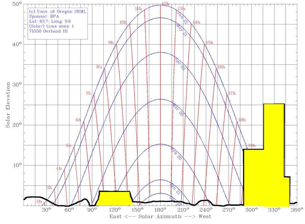
6 Temperature Challenge: Method does not consider the duration of possible shading, depending on the obstacle s width and location. That aspect is especially important for locations with high variation of sun elevation and azimuth throughout a year (high latitude countries).
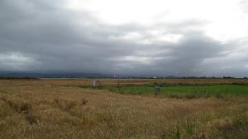
7 Example: Ørlandet
8 N NW E SE W

9 N NW E SE W

10 Example: Flisa

11
12
13
14 valuated Tools Tool Parameters Advantages Disadvantages Triangles (wood, metal, plastic) with three angles Leica Disto D8 determination if all obstacles are lower than the maxelevation angle defined for each class elevation angle height distance (<100 m) almost no costs easy to use relatively cheap easy to use measurements in multiple directions necessary only classification of precipitation sensors possible compass and GPS needed measurements in multiple directions necessary no usable datatransfer compass and GPS needed limited range under very bright conditions Smartphone application (Theodolite, GeoCam, ) elevation angle position azimuth angle distance internal compass and GPS reporting function not reliable accuracy measurements in multiple directions necessary Fisheye camera elevation angle relative azimuth angle (absolute requires external compass or camera with GPS) 360 picture GPS and compass required no distances GPS and compass required manual analysis afterwards low accuracy on low elevation angles Suneye 210 Shade Tool (incl. GPS) elevation angle position azimut angle one picture captures 360 internal GPS analysis software which produces data of elevation of shadowing objects no distances manual analysis afterwards low accuracy on low elevation angles Laser Rangefinder and Land Survey Tools elevation angle position azimut angle height distance often with internal GPS and/or compass datatransfer possible rather expensive more accurate than necessary? high user threshold measurements in multiple directions necessary Aerial photos & maptools distance internal GPS and compass also surface roughness lengths can be determined no information on height-of-obstacles available picture might be outdated
15 ome questions and thoughts Are there other tools which are easy to use and accurate enough (Disto not perfect)? Simplification for the actual fieldwork is needed.schemes, diagrams, Smartphone apps, Excel sheets - What are you using? Difficulties to judge if the natural relief is representative or not ( does a move of the station by 500m change the class obtained? )* How accurate is the description of natural shielding ( surrounded by obstacles of uniform height, seen under an elevation angle between 14 to 26 )* : Class jump from 1 to 3 when surrounding trees higher than 26.5 The shading duration due to one obstacle depends on its width and its location. That aspect is especially important for locations with high variation of sun elevation and azimuth throughout a year (high latitude countries) Weighting of shadowing effect by itself, monthly evaluation? Weighting of effect compared to distance of heat source/water extent? Complete classification of an existing network will take a couple of years if no extra classification resources are available Archiving and maintaining good and usable documentation of classification results needs good planning and extra resources How to further use the results (statistics, quality stamp of station, external cooperation)? How to improve the scheme without overloading it?
16
Leica DISTO X4 Designed for bright, outdoor environments
 Leica DISTO X4 Designed for bright, outdoor environments Pointfinder camera The DISTO X4 is equipped with a Pointfinder camera allowing you to easily target distant objects in bright sunlight. Even if
Leica DISTO D2 Laser Distance Meter
 Leica DISTO D2 Laser Distance Meter Lightweight. Compact. Powerful. Page 1 of 5 Now with Bluetooth, a fully integrated intelligent endpiece, a bright white display and an ISO certified measuring engine
The smartest solution to measuring and documenting
 Page 1 of 5 Leica DISTO D810 Laser Distance Meter The smartest solution to measuring and documenting World s first: The Leica DISTO D810 touch is the first laser distance meter world-wide with a touch
Leica DISTO D1 Laser Distance Meter
 Leica DISTO D1 Laser Distance Meter Experience the difference! Page 1 of 5 At the touch of a button the Leica DISTO D1 measures heights, distances as well as niches quickly and reliably. Complicated or
Leica DISTO X3 Designed for tough, rugged conditions
 Leica DISTO X3 Designed for tough, rugged conditions The rugged Leica DISTO X-series combines innovative measuring technologies with a site-proof design and simple user interface. Together with the Leica
Leica DISTO D110 Laser Distance Meter
 Page 1 of 5 Leica DISTO D110 Laser Distance Meter Small size, big possibilities The new Leica DISTO D110 is the first laser distance meter with Bluetooth Smart that fits to a pocket. Its handy design with
Leica DISTO S910 Measure point data and create plans
 Leica DISTO S910 Measure point data and create plans The world s first Measure anything from anywhere with P2P Technology It s been over 20 years since Leica Geosystems launched the first hand-held laser
Weather station AP 257/51
 Gamma instabus Weather station GPS AP 257/61 Weather station AP 257/51 Technical product information 5WG1 257-3AB61 5WG1 257-3AB51 Weather station with sensors to survey temperature, brightness, rain and
Leica DISTO D410 Laser Distance Meter
 Page 1 of 5 Leica DISTO D410 Laser Distance Meter Precise targeting and simple outdoor measurement! The new Leica DISTO D410 stands for easy and effortless outdoor distance measurement. With its digital
Weather station GPS AP 257/61 Weather station AP 257/51
 Gamma instabus Weather station GPS AP 257/61 Weather station AP 257/51 Technical product information 5WG1 257-3AB61 5WG1 257-3AB51 Weather station with sensors to survey temperature, brightness, rain and
Leica DISTO S910 Measure point data and create plans
 Leica DISTO S910 Measure point data and create plans The world s first Measure anything from anywhere with P2P Technology It s been over 20 years since Leica Geosystems launched the first hand-held laser
Solmetric isv iphone Application. User Manual
 Solmetric isv iphone Application User Manual Version 1.0 Copyright 2010 Solmetric Corporation www.solmetric.com About Solmetric isv The Solmetric isv Sun Viewer application uses the iphone camera to provide
Sensor technology for mobile robots
 Laser application, vision application, sonar application and sensor fusion (6wasserf@informatik.uni-hamburg.de) Outline Introduction Mobile robots perception Definitions Sensor classification Sensor Performance
How to use Leica DISTO D510
 How to use Leica DISTO D510 Switch On and Off The Press key switches and activates the laser in a single press. once quickly to shoot a distance or... Press and hold for 2 seconds to activate continuous
Setting up a 3D Environment for the City of Portland
 Setting up a 3D Environment for the City of Portland www.learn.arcgis.com 380 New York Street Redlands, California 92373 8100 USA Copyright 2018 Esri All rights reserved. Printed in the United States of
User Manual 2.1.1(draft)
") User Manual 2.1.1(draft) Rev. March 31, 2017 Introduction BallisticsARC has 3 modes; Chart, Map, and Comp. Each mode produces solutions independently, however data entered through the main menu will apply
User Manual 2.1.1(draft) Rev. March 31, 2017 Introduction BallisticsARC has 3 modes; Chart, Map, and Comp. Each mode produces solutions independently, however data entered through the main menu will apply
Leica DISTO UP TO ANY TASK
 Leica DISTO UP TO ANY TASK Content Leica DISTO TM Accessories Technical data 4-19 20 21-22 2 When it has to be right outstanding measuring performance, built on decades of experience Leica Geosystems has
in accordance with ISO Leica DISTO D410/D510 The original laser distance meter
 We keep our promises in accordance with ISO 16331-1 Leica DISTO D410/D510 The original laser distance meter Accuracy & range Colour display and digital Pointfinder with 4x zoom Precise targeting and measuring
Leica Disto X310 Robust multifunctionality-120 Meter Laser Distance Meter / Rangefinder
 Leica Disto X310 Robust multifunctionality-120 Meter Laser Distance Meter / Rangefinder MRP Rs.18,000 Free Home Delivery Offer Price Rs.11,700 Inclusive of Taxes Save Rs.6,300 3 Years Replacement Warranty
Geometry of Aerial photogrammetry. Panu Srestasathiern, PhD. Researcher Geo-Informatics and Space Technology Development Agency (Public Organization)
") Geometry of Aerial photogrammetry Panu Srestasathiern, PhD. Researcher Geo-Informatics and Space Technology Development Agency (Public Organization) Image formation - Recap The geometry of imaging system
Geometry of Aerial photogrammetry Panu Srestasathiern, PhD. Researcher Geo-Informatics and Space Technology Development Agency (Public Organization) Image formation - Recap The geometry of imaging system
Binoculars. with. Digital Compass. Instruction Manual. Model: Lit. #: /08-12
 Binoculars with Digital Compass Model: 137570 Instruction Manual Lit. #: 98-1192/08-12 Right Eyepiece Focus Compass Power Switch Battery Cover Left Eyepiece Focus Parts Reference Tripod Attachment Socket
The MCS shade evaluation procedure. Part 2 How to record shade onto the chart
 The MCS shade evaluation procedure Part 2 How to record shade onto the chart The MCS shade evaluation procedure Part 1 The procedure explained (previous presentation) Part 2 How to record shade onto the
GIS Data Collection. This chapter reviews the main methods of GIS data capture and transfer and introduces key practical management issues.
 9 GIS Data Collection OVERVIEW This chapter reviews the main methods of GIS data capture and transfer and introduces key practical management issues. It distinguishes between primary (direct measurement)
Objectives for Terrain Week
 The Terrain Correction Chuck Connor, Laura Connor Potential Fields Geophysics: Terrain Week for Terrain Week Learn about the terrain correction The inner terrain correction Learn about The outer terrain
Applied Cartography and Introduction to GIS GEOG 2017 EL. Lecture-7 Chapters 13 and 14
 Applied Cartography and Introduction to GIS GEOG 2017 EL Lecture-7 Chapters 13 and 14 Data for Terrain Mapping and Analysis DEM (digital elevation model) and TIN (triangulated irregular network) are two
Android mobile devices -- Lesson 3 Cameras
 Android mobile devices -- Lesson 3 Cameras What we will explain in this lesson:- Using the Camera The camera is such an effective tool that we will spend this lesson on that alone. The camera on an Android
Copyright The McGraw-Hill Companies, Inc. Permission required for reproduction or display.
 Chapter 13. TERRAIN MAPPING AND ANALYSIS 13.1 Data for Terrain Mapping and Analysis 13.1.1 DEM 13.1.2 TIN Box 13.1 Terrain Data Format 13.2 Terrain Mapping 13.2.1 Contouring 13.2.2 Vertical Profiling 13.2.3
Leica DISTO. Precise measurements Exactly what you need.
 Leica DISTO Precise measurements Exactly what you need. Measuring with the Leica DISTO Simple, quick and accurate! Quick and efficient You can measure distances at the touch of a button, in just a few
Introduction. Step 1. Build a Rifle Step 2. Choose a Mode Step 3. Establish Position Step 4. Obtain Atmospherics Step 5. Designate a Target
 User Manual 1.1.1 Introduction BallisticsARC currently has 2 modes, and each mode produces solutions independently. However, data entered through the main menu will apply to both modes. The only order
IKE 3 User Guide. Copyright 2015 IKEGPS LTD. IKE
 IKE 3 User Guide Copyright 2015 IKEGPS LTD. IKE3-102-15-12-1.0 Introduction IKE is a location-based measuring solution that will greatly increase your productivity when undertaking utility asset management
Third Rock from the Sun
 Geodesy 101 AHD LiDAR Best Practice The Mystery of LiDAR Best Practice Glenn Jones SSSi GIS in the Coastal Environment Batemans Bay November 9, 2010 Light Detection and Ranging (LiDAR) Basic principles
MODELLING FOREST CANOPY USING AIRBORNE LIDAR DATA
 MODELLING FOREST CANOPY USING AIRBORNE LIDAR DATA Jihn-Fa JAN (Taiwan) Associate Professor, Department of Land Economics National Chengchi University 64, Sec. 2, Chih-Nan Road, Taipei 116, Taiwan Telephone:
Collecting Data on your Phone or Tablet. Tyler Gakstatter Resource Supply LLC Lake Oswego, OR
 Collecting Data on your Phone or Tablet Tyler Gakstatter Resource Supply LLC Lake Oswego, OR Who can benefit from using smartphones and tablets? One-man show to large field crews. Create maps and push
Camtraptions PIR Motion Sensor Manual. Firmware Version 2.1
 Camtraptions PIR Motion Sensor Manual Firmware Version 2.1 Index What is a PIR Motion Sensor?... 3 Controls... 4 Dials... 4 Switches... 4 On-off Switch... 5 Inserting Batteries... 6 Red LED Indicator...
Gregory Walsh, Ph.D. San Ramon, CA January 25, 2011
 Leica ScanStation:: Calibration and QA Gregory Walsh, Ph.D. San Ramon, CA January 25, 2011 1. Summary Leica Geosystems, in creating the Leica Scanstation family of products, has designed and conducted
Mapping Photoperiod as a Variable in Vegetation Distribution Analysis. Photoperiod is defined as the duration of time for which an organism receives
 Paul Southard December 7 th, 2017 Mapping Photoperiod as a Variable in Vegetation Distribution Analysis Introduction Photoperiod is defined as the duration of time for which an organism receives illumination.
GeoMax Total Station Zoom30 Series
 GeoMax Total Station Zoom30 Series GeoMax About Us GeoMax is an internationally active company developing, manufacturing and distributing quality construction and surveying instruments. We provide a comprehensive
LIDAR and Terrain Models: In 3D!
 LIDAR and Terrain Models: In 3D! Stuart.green@teagasc.ie http://www.esri.com/library/whitepapers/pdfs/lidar-analysis-forestry.pdf http://www.csc.noaa.gov/digitalcoast/_/pdf/refinement_of_topographic_lidar_to_create_a_bare_e
Leica DISTO TM. The original laser distance meter
 Leica DISTO TM The original laser distance meter Why do you make your life so miserable? There is an alternative: Quick and efficient Just press the button and measure. One person measuring that saves
ACIAR MAD Masterclass Canberra, 7-9 June 2016
 ACIAR MAD Masterclass Canberra, 7-9 June 2016 Mobile Acquired Data Hardware and Fieldwork Tips Stuart Higgins Director Agricultural Impact International Pty Ltd T: +61 (0)438 987502 E: stuart@agimpact.org
TerraScan New Features
 www.terrasolid.com TerraScan New Features Arttu Soininen 03.02.2016 32 & Various Improvements Compute normal vectors action on project also without trajectory information Multiple source classes in Classify
GPS/GIS Activities Summary
 GPS/GIS Activities Summary Group activities Outdoor activities Use of GPS receivers Use of computers Calculations Relevant to robotics Relevant to agriculture 1. Information technologies in agriculture
UNIVERSAL CONTROL METHODOLOGY DESIGN AND IMPLEMENTATION FOR UNMANNED VEHICLES. 8 th April 2010 Phang Swee King
 UNIVERSAL CONTROL METHODOLOGY DESIGN AND IMPLEMENTATION FOR UNMANNED VEHICLES 8 th April 2010 Phang Swee King OUTLINES Introduction Platform Design Helicopter Avionics System Ground Station Sensors Measurement
MODERN TECHNOLOGIES IN RESEARCH AND EDUCATION AT THE INSTITUTE OF GEODESY AND GEOINFORMATICS
 MODERN TECHNOLOGIES IN RESEARCH AND EDUCATION AT THE INSTITUTE OF GEODESY AND GEOINFORMATICS Andrzej Borkowski, Wojciech Sowa, Jarosław Bosy, Bernard Kontny Institute of Geodesy and Geoinformatics DRUŽICOVÉ
EVOLUTION 6000 Thermal Imaging Cameras. Because every life has a purpose
 EVOLUTION 6000 Thermal Imaging Cameras Because every life has a purpose MSA protects firefighters lives. MSA introduced one of the first firefighting thermal imaging cameras over a decade ago. In the years
Vegetation height maps derived from digital elevation models the next innovation in the production of orienteering maps?
 Vegetation height maps derived from digital elevation models the next innovation in the production of orienteering maps? Development of Orienteering Maps. 1. Revolution 20 years ago: Digital Cartography
Measurement of Direction: Bearing vs. Azimuth
 Week 5 Monday Measurement of Direction: Bearing vs. Azimuth Bearing Is an angle of 90 o or less Measured from either North or South in easterly & westerly directions. North 22 o West, South 89 o West,
Characterizing Strategies of Fixing Full Scale Models in Construction Photogrammetric Surveying. Ryan Hough and Fei Dai
 697 Characterizing Strategies of Fixing Full Scale Models in Construction Photogrammetric Surveying Ryan Hough and Fei Dai West Virginia University, Department of Civil and Environmental Engineering, P.O.
2. POINT CLOUD DATA PROCESSING
 Point Cloud Generation from suas-mounted iphone Imagery: Performance Analysis A. D. Ladai, J. Miller Towill, Inc., 2300 Clayton Road, Suite 1200, Concord, CA 94520-2176, USA - (andras.ladai, jeffrey.miller)@towill.com
General GPS TPS ROB X POLE VOL RDN RPL Jobs management System settings (units, precision, parameters, etc.)
") XPAD Survey Modules XPAD Survey GPS TPS XPOLE General GPS TPS ROB XPOLE VOL RDN RPL Jobs management System settings (units, precision, parameters, etc.) Instruments GPS GPS TPS ROB XPOLE VOL RDN RPL Instrument
XPAD Survey Modules XPAD Survey GPS TPS XPOLE General GPS TPS ROB XPOLE VOL RDN RPL Jobs management System settings (units, precision, parameters, etc.) Instruments GPS GPS TPS ROB XPOLE VOL RDN RPL Instrument
Leica DISTO D5 Measure distances and much more
 Leica DISTO D5 Measure distances and much more Leica DISTO D5 Can it reach that far? WORLD FIRST: DIGITAL POINTFINDER WITH 4x ZOOM! The Leica DISTO D5 is designed with many functions and features to make
Trigonometry for Surveyors p. 1 Trigonometry p. 1 Angles and Their Measurement p. 1 Expressing the Fractional Part of a Degree in Minutes and Seconds
 Trigonometry for Surveyors p. 1 Trigonometry p. 1 Angles and Their Measurement p. 1 Expressing the Fractional Part of a Degree in Minutes and Seconds p. 1 Expressing an Arc in Radians p. 2 Angle Conversions
5 Classifications of Accuracy and Standards
 5 Classifications of Accuracy and Standards 5.1 Classifications of Accuracy All surveys performed by Caltrans or others on all Caltrans-involved transportation improvement projects shall be classified
How to use Leica DISTO X310
 How to use Leica DISTO X310 Switch On and Off The red Dist on key displayed here switches on the instrument and the laser in a single press. Pressing the Clear off button for 2 seconds switches the instrument
Light Detection and Ranging (LiDAR)
") Light Detection and Ranging (LiDAR) http://code.google.com/creative/radiohead/ Types of aerial sensors passive active 1 Active sensors for mapping terrain Radar transmits microwaves in pulses determines
Light Detection and Ranging (LiDAR) http://code.google.com/creative/radiohead/ Types of aerial sensors passive active 1 Active sensors for mapping terrain Radar transmits microwaves in pulses determines
Leica Disto tm The Visionary One for in and outdoors NEW SWISS Technology by Leica Geosystems
 Leica Disto tm A8 The Visionary One for in and outdoors x digital zoom NEW tilt sensor SWISS Technology by Leica Geosystems 75677en_Leica Folder_A8.indd 6.0.006 0:4:49 Uhr Leica Disto TM A8 The Visionary
The Ranger 1800 Rangefinder
 Ranger Specifications Range Reflective: 9 yards (9 1646 meters) Range Deer: 9 900 yards (9 822 meters) Accuracy: + /- 3 yards @ 1000 yards Maximum Angle Reading: +/- 60 degrees (INC 50) Measuring Time:
R13 PART-A PART-B. 2. a) Explain method of intersection in Plane table surveying b) What is error of closure? How is it balanced graphically?
 Explain method of intersection in Plane table surveying b) What is error of closure? How is it balanced graphically?") SET - 1 1. a) Write the classifications of surveying? b) Distinguish between closed traverse and open traverse. c) Define contouring. What do you understand by contour interval and on what factors it depends?
SET - 1 1. a) Write the classifications of surveying? b) Distinguish between closed traverse and open traverse. c) Define contouring. What do you understand by contour interval and on what factors it depends?
Over the years, they have been used several tools to perform aerial surveys of analyzed to archaeological sites and monuments. From the plane to the
 Over the years, they have been used several tools to perform aerial surveys of analyzed to archaeological sites and monuments. From the plane to the balloon, the balloon to the telescopic rods, all of
DIGITAL SURFACE MODELS OF CITY AREAS BY VERY HIGH RESOLUTION SPACE IMAGERY
 DIGITAL SURFACE MODELS OF CITY AREAS BY VERY HIGH RESOLUTION SPACE IMAGERY Jacobsen, K. University of Hannover, Institute of Photogrammetry and Geoinformation, Nienburger Str.1, D30167 Hannover phone +49
ZEISS COMET LƎD 2 Simple and quick 3D measurements. The new, mobile system for optical 3D scanning
 ZEISS COMET LƎD 2 Simple and quick 3D measurements The new, mobile system for optical 3D scanning COMET LƎD 1 Success Story 2011 May COMET LƎD 2M first presentation at Control 2011 2011 December COMET
Merging LiDAR Data with Softcopy Photogrammetry Data
 Merging LiDAR Data with Softcopy Photogrammetry Data Cindy McCallum WisDOT\Bureau of Technical Services Surveying & Mapping Section Photogrammetry Unit Overview Terms and processes Why use data from LiDAR
2010 LiDAR Project. GIS User Group Meeting June 30, 2010
 2010 LiDAR Project GIS User Group Meeting June 30, 2010 LiDAR = Light Detection and Ranging Technology that utilizes lasers to determine the distance to an object or surface Measures the time delay between
Software for Land Development Professionals
 Software for Land Development Professionals SurvNET Carlson SurvNET is SurvCADD's Network Least Squares Reduction (NLSA) program. This module will perform a least squares adjustment and statistical analysis
GeoMax Total Station Zoom30 Series
 GeoMax Total Station Zoom30 Series GeoMax About Us GeoMax is an internationally nology group with strong mar- The close cooperation within active company developing, ket positions within measure- the Hexagon
XT550. Intrinsically safe for potentially explosive environments. Shaft Alignment
 XT550 Intrinsically safe for potentially explosive environments. Shaft Alignment THIS IS EASY ALIGNMENT HORIZONTAL PROGRAM The user interface is intuitive and guides you through the measurement process.
IMPORTANT SAFETY INSTRUCTIONS
 CONTENTS Important safety instructions... Specified Conditions of Use... Error Code Table... Overview... Change batteries...4 Corner Pin...4 Belt Clip...4 Function Switch, Pythagoras, Measuring Reference...5
Technical English -I 5 th week SURVEYING AND MAPPING
 Technical English -I 5 th week SURVEYING AND MAPPING What is surveying? It is the art of defining the positions of natural and man-made made features on the Earth s surface. Basic Tasks and Features in
XT550. Intrinsically safe for potentially explosive environments. Shaft Alignment
 XT550 Intrinsically safe for potentially explosive environments. Shaft Alignment THIS IS EASY ALIGNMENT HORIZONTAL PROGRAM The user interface is intuitive and guides you through the measurement process.
Surveying Prof. Bharat Lohani Indian Institute of Technology, Kanpur. Lecture - 1 Module - 6 Triangulation and Trilateration
 Surveying Prof. Bharat Lohani Indian Institute of Technology, Kanpur Lecture - 1 Module - 6 Triangulation and Trilateration (Refer Slide Time: 00:21) Welcome to this another lecture on basic surveying.
IMPORTANT SAFETY INSTRUCTIONS Do not use the product before you have studied the Safety instructions and the User Manual.
 CONTENTS Important safety instructions... Specifi ed Conditions of Use... Error Code Table... Overview... Change batteries...4 Corner Pin...4 Belt Clip...4 Function Switch, Measuring Reference, Pythagoras...5
Stockpile Volume Calculation White Paper by Atterbury Consultants, Inc.
 White Paper by In recent times, calculating stockpile volumes has been difficult and expensive. This white paper explains an easy, yet consistently accurate method for measuring stockpiles and calculating
XT660. Alignment system for all important steps of machine installation. Shaft Alignment
 XT660 Alignment system for all important steps of machine installation. Shaft Alignment MEASUREMENT INDEPENDENCE EASY-LASER GENERATION XT Easy-Laser XT660 is the second member of our Generation XT alignment
Field-Map technology. Forestry oriented tool for measurement and mapping in difficult conditions. GPS workshop Montpellier, France
 Field-Map technology Forestry oriented tool for measurement and mapping in difficult conditions GPS workshop Montpellier, France 11.-13.10.2010 Measuring forest Be ready for: - no or weaker GPS signal
Chapters 1-4: Summary
 Chapters 1-4: Summary So far, we have been investigating the image acquisition process. Chapter 1: General introduction Chapter 2: Radiation source and properties Chapter 3: Radiation interaction with
release LASER DISTANCE METER
 release LASER DISTANCE METER Always combining technology, durability, high-performance and comfort in handling its products, Starrett is launching in the Market another innovation to make easier the everyday
FOR QUALITY THAT LASTS!
 Stereo Microscopes for Assembly, Inspection, and Quality Control FOR QUALITY THAT LASTS! Leica EZ4, Leica EZ4 W (Wi-Fi), and Leica EZ4 E (Ethernet) 2 LEICA E SERIES FOR QUALITY THAT LASTS! DEPENDABLE AND
New in SoundPLANessential 4.1 / 4.0 December 2017
 Installation Page 1 New in SoundPLANessential 4.1 / 4.0 December 2017 Installation SoundPLANessential 4.1 can be installed parallel to earlier SoundPLANessential versions, older versions do not need to
Alignment Software for Bearing Ways and Bores
 Alignment Software for Bearing Ways and Bores A well-rounded system, in combination with the display unit, is the optimum solution for the alignment of bearing ways and bores. The following functions and
Verwendung des Applikationsprogramms. 1. Function overview. GAMMA instabus Application program description. September 2010
 Verwendung des Applikationsprogramms Product family: Product type: Manufacturer: Physical Sensors Weather station w/ integrated sensors Siemens Name: Weather station WS1 (GPS) AP 257/32 Order no.: 5WG1
Leica Viva Quick Guide Leica Viva: Quick Grid Guide
 Leica Viva Quick Guide Leica Viva: Quick Grid Guide Leica SmartWorx Viva has a simplified means of quickly creating a site co-ordinate system called Quick Grid. This has several methods depending on site
VISION SENSORS VISION SENSORS. Fully embedded vision sensor 3.5 VSC configurator 7 different controls Memorisation of 8 inspections
 VISION SENSORS VISION SENSORS Fully embedded vision sensor 3.5 VSC configurator 7 different controls Memorisation of 8 inspections The SVS1 series is the easiest solution for machine vision applications.
The Ranger 1300 Rangefinder
 Ranger Specifications Range Reflective: 9 yards (9 1189 meters) Range Deer: 9 600 yards (9 594 meters) Accuracy: + /- 3 yards @ 1000 yards Maximum Angle Reading: +/- 60 degrees (INC 50) Measuring Time:
Laser technology has been around
 Mobile scanning for stockpile volume reporting Surveying by André Oberholzer, EPA Survey The versatility and speed of mobile lidar scanning as well as its ability to survey large and difficult areas has
BRx6 Sensor Calibration Using SurvCE/SurvPC
 OVERVIEW BRx6 Sensor Calibration Using SurvCE/SurvPC The BRx6 internal sensors (tilt, accelerometer and compass) must be calibrated in order to use the electronic bubble and tilted pole corrections in
Leica Rugby 320 SG & 410/420 DG The toughest players on big fields
 Leica Rugby 320 SG & 410/420 DG The toughest players on big fields Provided by Xpert Survey Equipment Click Leica Rugby 420DG for Product Info and Updated Pricing n Construction n Machine Control n Agriculture
Correcting INS Drift in Terrain Surface Measurements. Heather Chemistruck Ph.D. Student Mechanical Engineering Vehicle Terrain Performance Lab
 Correcting INS Drift in Terrain Surface Measurements Ph.D. Student Mechanical Engineering Vehicle Terrain Performance Lab October 25, 2010 Outline Laboratory Overview Vehicle Terrain Measurement System
OE-STYLED HIGH BR IGHTNESS R EAR VIEW MIR R OR MONITOR
 Check Surrounding for safety Le guideline move Long press to set guide line Right guideline move Check Surrounding for safety OEM MARKET MOUNT 9 7 PUSH OUT OPEN Video in Rearview mirror monitor Mirror
Total station assignment
 Total station assignment Objective: Control survey densification for detail surveying Location: Otaniemi campus, Innopoli 3 park area Equipment: Total Station (or electronic theodolite) and target device
SurvNET Lesson One - Processing an Assumed Coordinate System 2D Total Station Network
 SurvNET Lesson One - Processing an Assumed Coordinate System 2D Total Station Network This tutorial is divided into two lessons covering the process of reducing and adjusting raw survey data into final
Recent Advances in GPS/GIS/Remote Sensing Technologies
 Recent Advances in GPS/GIS/Remote Sensing Technologies EGUG Conference Galveston, TX October 15, 2003 By: Ashok Wadwani Applied Field Data Systems, Inc. Houston, Texas Phone No.: 281-579-0492 e-mail: afdsaw@aol.com
INSPIRE 1 Quick Start Guide V1.0
 INSPIRE Quick Start Guide V.0 The Inspire is a professional aerial filmmaking and photography platform that is ready to fly right out of the box. Featuring an onboard camera equipped with a 0mm lens and
Locating the Shadow Regions in LiDAR Data: Results on the SHARE 2012 Dataset
 Locating the Shadow Regions in LiDAR Data: Results on the SHARE 22 Dataset Mustafa BOYACI, Seniha Esen YUKSEL* Hacettepe University, Department of Electrical and Electronics Engineering Beytepe, Ankara,
Trimble Positions Mobile Extension
 RELEASE NOTES Trimble Positions Mobile Extension These release notes provide important information about the Trimble Positions Mobile extension version 10.2.0.3. Please read these release notes carefully.
Machine Geometry Measurement
 Machine Geometry Measurement BR 1010 E 09/15 Measurement Technology Straightness ProLine for straightness measurement, page 6 Interferometry µline for displacement measurement, page 8 Levelling µlevel
CHAPTER 6. Computer Model
 CHAPTER 6 Computer Model 6.1 Introduction In the previous chapters, the underlying principles that a designer of photovoltaic systems needs to understand before beginning the design process have been addressed.
Camera Deployment Guide
 Camera Deployment Guide Page 1 of 8 Overview of Camera Deployment Procedure You will be deploying your cameras in sets of 3: o On trail one camera that captures picture of traffic on a hiking trail o Near
USE OF DRONE TECHNOLOGY AND PHOTOGRAMMETRY FOR BEACH MORPHODYNAMICS AND BREAKWATER MONITORING.
 Proceedings of the 6 th International Conference on the Application of Physical Modelling in Coastal and Port Engineering and Science (Coastlab16) Ottawa, Canada, May 10-13, 2016 Copyright : Creative Commons
The Use of Photogrammetryin Measuring Geologic Structures and Creating a 3D Model on Exposed Rock Faces
 The Use of Photogrammetryin Measuring Geologic Structures and Creating a 3D Model on Exposed Rock Faces T. T. Dang a * a University of Mining and Geology, Hanoi, Vietnam * thanh.dangtrung@rub.de(corresponding
Bear Power Supplies Engineering Department Smart Power Supply Test Bench
 The purpose of this document is to validate that the 1.0 Fundamental Overview The smart power supply test bench is an automated test fixture for a power supply and control board assembly. It will fully