Recent Advances in GPS/GIS/Remote Sensing Technologies
|
|
|
- Gregory Stanley Boone
- 5 years ago
- Views:
Transcription
1 Recent Advances in GPS/GIS/Remote Sensing Technologies EGUG Conference Galveston, TX October 15, 2003 By: Ashok Wadwani Applied Field Data Systems, Inc. Houston, Texas Phone No.:
2 ADVANCES IN GPS/GIS/REMOTE SENSING TECHNOLGY Ease of use-minimal training Economical Hardware-Lighter
3 AREAS OF ADVANCEMENTS GPS RECEIVERS DATA COLLECTORS FIELD DATA COLLECTION SOFTWARE LASER RANGE FINDER DIGITAL CAMERAS AND GIS AVL REMOTE SENSING ARC GIS EXTENSIONS
4 GPS RECEIVERS Smaller Cheaper GPS Accuracy With the elimination of SA, autonomous accuracy is much better. Stand alone accuracy of about 10 meters. Availability of Coast Guard Beacons and WAAS for DGPS Real time differential service available throughout the world at reasonable cost
5 COAST GUARD BEACONS Available in several areas of the country and plans are to have the entire USA covered. Download coverage areas from the National Atmospheric Administration web site.
6 DGPS CORRECTION-WAAS WAAS-WIDE AREA AUGMENTATION SYSTEM FAA is developing this system to help commercial aircraft use GPS as means of navigation Net work of reference stations monitoring and calculating standard GPS errors and broadcasting through geostationary satellite
7 DGPS CORRECTION-WAAS CON T Correction method similar to Coast Guard Beacon except beacon broadcasts corrections from ground stations at low frequency which are more susceptible to weather interference and has limited range WAAS provides extensive coverage which is less susceptible to weather, signal interference
8 DGPS CORRECTION-WAAS CON T Provides about 3 meter accuracy 95% of the time Better accuracy is experienced in lower latitudes. Accuracy worsens as you head north and is worse along northern most areas from Seattle through Chicago and Boston As more satellites are launched this will change & entire U.S. is expected to be covered
9 DATA COLLECTORS
10 TRADITIONAL UNITS FOR DATA COLLECTION For data collection, traditional GPS units use either: On board memory or External data loggers
11 DISADVANTAGES OF TRADITIONAL DATA COLLECTORS In most cases, software is difficult to learn Units are vendor specific to GPS engines Cannot be used for anything else. Proprietary operating system Slow processor - difficult to manipulate data Small screen size Low battery life Replacement units expensive
12 NEW GENERATION DATA COLLECTORS Hand held Personal Digital Assistant (PDA) and ruggedized PC s. Palm Pilots Units with Windows Pocket PC operating systems -PDA Ruggedized PC s Tablet PC s
13 MANUFACTURERS DAP SHARP HP/COMPAQ TRIPOD DATA SYSTEMS VIA WALKABOUT PANASONIC FUJITSU JUNIPER SYSTEMS PSION

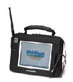
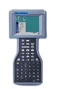


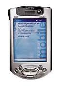
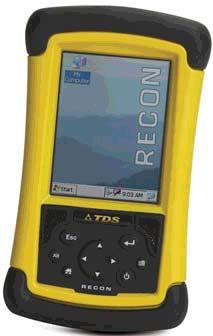
14 Panasonic Toughbook 07 Hammerhead TDS Ranger Panasonic Toughbook 01 Compaq ipaq TDS Recon Allegro

15 Compaq ipaq Rugged Case Enhance the durability of your ipaq Pocket PC without sacrificing style. The Rugged Case provides: Increased durability of the ipaq Pocket PC and drops from up to four feet Compliance w/ IP54 standards for water and dust resistance Access to ipaq Pocket PC jacks, ports, and Expansion Pack slots A clear, hard plastic window that prevents screen damage and allows use of touchscreen and buttons Removable belt clip

16 Pretec Compact Flash GPS Card Specifications CompactFlash size card: 36.4mm X 42.8mm X 3.3mm Product Application: Windows CE, Pocket PC, Automotive applications, Marine Navigation, Aviation, & Timing applications: Time Mark: Once per second Reacquisition: Hot Start = 8 sec., Warm Start = 38 +/- 5 sec., Cold Start = 48 +/- 5 sec. Navigation Update Rate: Once per second Serial Data Output Protocol: SirF binary serial I/O messages or NMEA-0183 serial I/O messages Power Consumption: Operation Current = 190mA +/- 10%, Power: = 0.63W +/- 10% Environment Conditions: Operating temperature: 0 degrees C to 50 degrees C Humidity: 95%
17 ADVANTAGES OF NEW GENERATION DATA COLLECTORS Economical - $300-6,000 (?) Easy to use - most of the users are already familiar with the Palm, Pocket PC operating systems, and Windows O/S. Can be used with or without GPS Can be used for other applications Long battery life Light Weight Color Display Voice Recording systems Pen-based 2 serial ports Memory cards
18 FIELD DATA COLLECTION SOFTWARE
19 TRADITIONAL FIELD DATA COLLECTON SOFTWARE Difficult to learn Vendor specific to their GPS engines Expensive Operate only on Windows platform
20 NEW SOFTWARE FIELDWORKER SOLO ARCPAD LANDMARK OTHERS
21 ADVANTAGES OF NEW SOFTWARE Economical - $500 - $1,000 Have capability to add background maps or digital ortho photos Will run with MR. SID Not vendor specific to GPS engine Recreational to survey grade Easy to use Can edit data dictionary in the field Most of them have a similar version running on the PC, so learning and training is easier. Accept two serial inputs simultaneously Digital camera input
22 EXAMPLE SCREENS

23 RASTER IMAGES
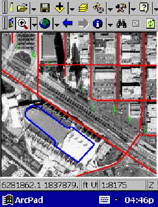
24 IMAGE
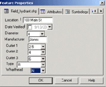
25 FEATURE PROPERTIES

26 LOGGING DATA
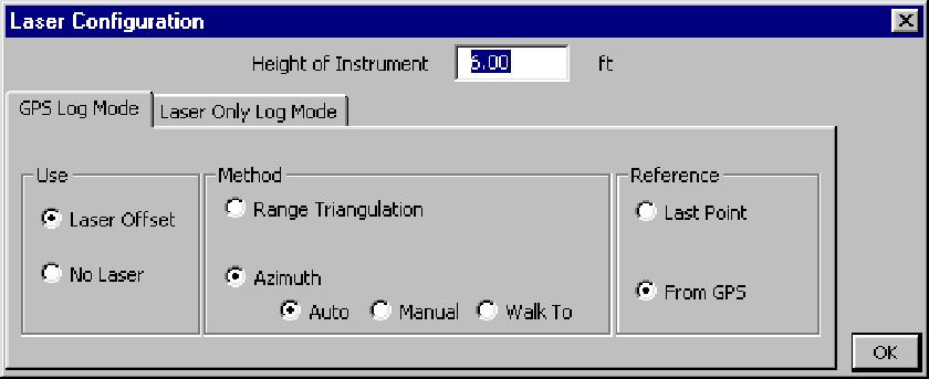
27 OFFSETS
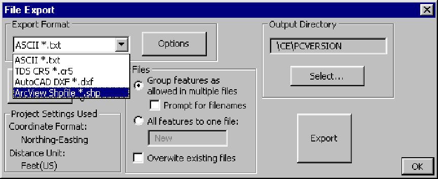
28 EXPORTING
29 EXAMPLES OF DATA DICTIONARY Poles - Material: wood/metal -Diameter -Asset no. - Manufacturer - Number of conductors -Location
30 EXAMPLES OF DATA DICTIONARY (CON T) Transformer - Location - Rating: -Accessible: Y/N -Inventory Number -Manufacturer
31 LASER RANGE FINDERS
32 Data acquisition challenge #1 You can t get there from here Terrain separates you from the feature you want to map.
33 Data collection challenge #2 You can get there... but don t want to Also known among field mapping technicians and postal delivery personnel as the Doberman factor.
34 Data collection challenge #3 You can get there... but the satellite can t
35 Data collection challenge # 4 You can get there, and there, and there...


36 To address these challenges, consider using laser mapping systems
37 The key to laser mapping is... You don t have to get there from here! Instead, just shoot it with the laser.
38 What makes a laser mapping system work? Eye-safe diode pulse laser measures distance without reflectors. Digital flux-gate compass or angle encoder (not affected by magnetic fields) Electronic tilt sensor determines vertical angle.
39 General range finding specifications Multiple pulse averaging gives better accuracy. Mapping grade lasers vary in accuracy from about 5 cm. up to 1.5 meters. Maximum range varies from 1000 ft... up to 2500 ft.
40
41


42

43
44 Direct GPS Integration GPS Data logging device CRITERION Laser gun
45 Indirect laser / GPS integration Features Laser GPS
46 Independent laser mapping Laser with data collection hardware and software. Base map coordinates or survey markers provide reference points. Features are accurate to base map and to each other. Can be geo-referenced again when more accurate base maps become available. Requires origin coordinates.
47 TYPICAL APPLICATIONS FOR LASER RANGE FINDERS IN UTILITIES Light pole inventory to determine horizontal distance, height and slopes Measurement of line pulls, line sag, bridge spans Line clearances Lay out surveys for transmission tower planning Tree conductor clearance Mapping of large number of features eg poles and which are hard to reach
48 DIGITAL CAMERA AND GIS
49 MediaMapper A desktop mapping software that links pictures and other files to GIS map layers. Creates media maps that can be used in Arcview GIS, MapInfo Professional, or on the web. The mapping solution for GIS users wanting a fast, easy way to link photographs or other multimedia files to map locations.

50 How MediaMapper Works With Digital Still Pictures Take digital pictures while recording GPS data. Media Mapper downloads the pictures and the GPS data file. Click the map to view the pictures of location.


51 Get the Picture Make the Map Take Pictures and Collect GPS data Pictures Link to Map Via GPS Metadata Download to MediaMapper Customize the Map

52 Environmental Application Pollution Monitoring Environmental Assessment Programs Hazardous Spills Public Education and Outreach Mandatory Reporting Waste Contamination Points Cleanup Areas Environmental Data Collection Water Management Wetlands
53 Benefits Works with Off-the-Shelf Components Small, Lightweight for Individual Users No Need for Expensive Outside Programs Simple to Operate Fast Turnaround from the Field to the Internet Quick Association of Images with Maps Creates.shp,.tab, or html maps
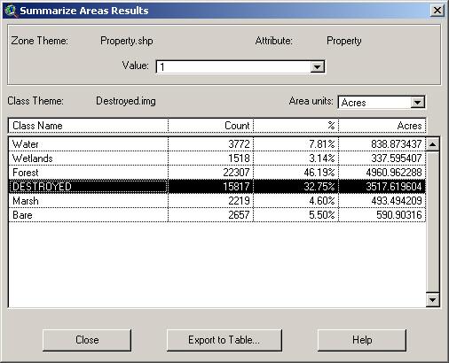
54 AVL Economical AVL units available for monitoring location of field crews in real time. Dispatch center can locate every individual truck in real time. End of day reports with information on miles traveled, stop time, drive time, places visited etc. Data transfer via radio, satellite, cell phones etc. 2-way communications
55 REMOTE SENSING Due to launching of new satellites, and improved digital aerial sensors quality and quantity of aerial data has improved several folds
56 ArcGIS SOFTWARE EXTENSIONS IMAGE ANALYSIS STEREO ANALYST
57 IMAGE ANALYSIS Operates on ESRI ARCGIS 8.3 Facilitates extraction of Imagery Creation of GIS ready imagery Land cover classification Change detection Image re projection Mosaicking
58 STEREO ANALYST Operates on ESRI ARCGIS 8.3 Performs 3D stereo feature collection in Geodatabase 2D TO 3D feature conversion tools for updating feature data set. Supports CAD formats


59 Change Detection
60
61 Example Damage Assessment Image Analysis
62 Example Damage Assessment Image Analysis

63 Example Damage Assessment Image Analysis

64 Future developments - Feature Updating Roads
User Manual Bluetooth GPS Receiver
 User Manual 2944308 Bluetooth GPS Receiver 02944308 at a glance 1. Introduction The 02944308 is a GPS receiver with Bluetooth interface and built-in active antenna for high sensitivity to tracking signal.
New trends of GIS terrain mapping with modern low cost GNSS technology
 New trends of GIS terrain mapping with modern low cost GNSS technology Tomáš Bláha / Magellan Professional Sales Manager Eastern Europe DATECS GIS Conference, March 27, 2009, Sofia Hotel Holiday Inn 1
MG-S01SP. SiRF Star III LowPower GPS Module. User s Manual Ver 1.03
 MG-S01SP SiRF Star III LowPower GPS Module User s Manual Ver 1.03 Contents 1. INTRODUCTION.... 3 OVERVIEW.... 3 MAIN FEATURES...... 3 2. TECHNICAL SPECIFICATIONS..... 4 2.1 ELECTRICAL CHARACTERISTICS.....
Overview of the Trimble TX5 Laser Scanner
 Overview of the Trimble TX5 Laser Scanner Trimble TX5 Revolutionary and versatile scanning solution Compact / Lightweight Efficient Economical Ease of Use Small and Compact Smallest and most compact 3D
Stockpile Volume Calculation White Paper by Atterbury Consultants, Inc.
 White Paper by In recent times, calculating stockpile volumes has been difficult and expensive. This white paper explains an easy, yet consistently accurate method for measuring stockpiles and calculating
Esri s ArcPad vs. ArcGIS Mobile vs. Trimble s TerraSync vs. TerraFlex Comparison
 ArcPad is mobile field mapping and data collection software designed for GIS professionals. It includes advanced GIS and GPS capabilities for capturing, editing and displaying geog bels, etc. as ArcMap
ArcPad 10 for Mobile GIS
 ArcPad 10 for Mobile GIS Electronic Data Solutions Jackson Beighle & Alison Walker 10/27/10 Workshop Agenda 1:30 2:00 What s new at ArcPad 10? 2:00 2:30 Hardware and Software Options for Mobile GIS 2:30
The Global Positioning Sytem II 10/13/ /13/2015 GEO327G/386G, UT Austin /13/2015 GEO327G/386G, UT Austin 5-4
 The Global Positioning System II Field Experiments Mexico DGPS Field Campaign Cenotes in Tamaulipas, MX, near Aldama 10/13/2015 GEO327G/386G, UT Austin 5-1 10/13/2015 GEO327G/386G, UT Austin 5-2 Are Cenote
IP-S2 HD. High Definition 3D Mobile Mapping System
 IP-S2 HD High Definition 3D Mobile Mapping System Integrated, turnkey solution Georeferenced, Time-Stamped, Point Clouds and Imagery High Density, Long Range LiDAR sensor for ultimate in visual detail
BT-335 Bluetooth Data Logger User Manual. Version 1.2
 BT-335 Bluetooth Data Logger User Manual Version 1.2 BT-335 page 2 Table of Content 1 Introduction and Features... 3 Introduction...3 Features...3 2 Specifications... 4 System Specifications...4 Bluetooth
Leica Zeno 20 More than GPS
 Leica Zeno 20 More than GPS TECHNOLOGIES Leica Zeno 20 does so much more The Leica Zeno 20 is much more than just GPS it is a fusion of great technologies. Powerful and easy, it s the ultimate geospatial
MobileMapper Pro. See What's Possible!
 MobileMapper Pro See What's Possible! Mobile Mapping Made Easy MobileMapper Pro Industrial Strength Mapping Solution MobileMapper Pro combines professional GIS data collection and navigation software in
Terrain Modeling and Mapping for Telecom Network Installation Using Scanning Technology. Maziana Muhamad
 Terrain Modeling and Mapping for Telecom Network Installation Using Scanning Technology Maziana Muhamad Summarising LiDAR (Airborne Laser Scanning) LiDAR is a reliable survey technique, capable of: acquiring
Iwane Mobile Mapping System
 Iwane Mobile Mapping System Geo-Imaging Mobile Mapping Solution Iwane Mobile Mapping System (IMMS) is high-efficient, easyto-use, end-to-end solution that provides tremendous flexibility in collecting,
QUICK START GUIDE. SOLO Forest
 QUICK START GUIDE SOLO Forest Software Installation 1. For PC installation, run the.msi file. 2. For Mobile device installation, copy the.cab file onto the device 3. Run the.cab file Starting the Program
Mapping & GIS Product Compatibility List
 3 June 2009 Mapping & GIS Product Compatibility List This document outlines the compatibility between Trimble Mapping & GIS field devices, versions of Trimble field software, versions of Trimble Office
Airborne Laser Survey Systems: Technology and Applications
 Abstract Airborne Laser Survey Systems: Technology and Applications Guangping HE Lambda Tech International, Inc. 2323B Blue Mound RD., Waukesha, WI-53186, USA Email: he@lambdatech.com As mapping products
Lincoln Electric System Pole Inventory & Inspection Project. Presented by: David Miller
 Lincoln Electric System Pole Inventory & Inspection Project Presented by: David Miller dmiller@les.com Presentation Outline LES Background Why was the project needed? How was the project developed? 2009
Fortuna Slim Bluetooth GPS Receiver
 Fortuna Slim Bluetooth GPS Receiver Product specification Reference Manual Fortuna Electronic Corporation 2005/04/20 All Rights Reserved Introduction Overview The Fortuna Slim Bluetooth GPS receiver is
MobileMapper CE FAQ. 8 September Thales MobileMapper CE FAQ Page 1
 MobileMapper CE FAQ 8 September 2005 What is MobileMapper CE? MobileMapper CE is the next generation handheld GIS mobile mapping device from Thales. MobileMapper CE offers integrated Bluetooth wireless
LTI Products. TruPulse Series. TruPulse Product Line. TruPulse 200 Yellow. TruPulse 200L. TruPulse 200X
 TruPulse Series TruPulse Product Line TruPulse 200 Yellow 7005025 TruPulse 200,YELLOW LTI Products Lightweight, low-cost laser rangefinder that measures Slope Distance and Inclination. Calculates Horizontal
trimble unmanned aircraft systems
 trimble unmanned aircraft systems FOR SURVEYING and MAPPING TRIMBLE UAS AERIAL IMAGING solution: INDUSTRY-LEADING UAS MAPPING SOLUTIONS FOR ALL YOUR APPLICATION NEEDS Trimble prides itself on being a leader
APPENDIX E2. Vernal Pool Watershed Mapping
 APPENDIX E2 Vernal Pool Watershed Mapping MEMORANDUM To: U.S. Fish and Wildlife Service From: Tyler Friesen, Dudek Subject: SSHCP Vernal Pool Watershed Analysis Using LIDAR Data Date: February 6, 2014
BRx6 Sensor Calibration Using SurvCE/SurvPC
 OVERVIEW BRx6 Sensor Calibration Using SurvCE/SurvPC The BRx6 internal sensors (tilt, accelerometer and compass) must be calibrated in order to use the electronic bubble and tilted pole corrections in
BT-R900. Bluetooth GPS Receiver. User s Manual. Date: April 2006 Version: 2.1. All Rights Reserved
 BT-R900 Bluetooth GPS Receiver User s Manual Date: April 2006 Version: 2.1 All Rights Reserved Page 1 Manual Revision History Revision Date Update Summary Issue 1.0 March 2006 Initial release Issue 2.1
GNSS/GPS Overview for the DEP Status and Trend Networks
 GNSS/GPS Overview for the DEP Status and Trend Networks Florida Department of Environmental Protection Tom Biernacki Video of this presentation is posted at https://fldeploc.dep.state.fl.us/appdata/status/sol
Airborne LiDAR Surveys and Data Delivery in the Pipeline Industry
 Airborne LiDAR Surveys and Data Delivery in the Pipeline Industry Carlos Femmer Faron Olivier October 25, 2011 October 25, 2011 GITA GIS for Oil and Gas Pipeline 2011 Organization Fugro is a decentralized
Brian Cooper, FIELDS Program Manager Charles Roth, Spatial Data Analyst Sean Ramach, Research Associate
 Brian Cooper, FIELDS Program Manager Charles Roth, Spatial Data Analyst Sean Ramach, Research Associate United States Environmental Protection Agency Region 5 Superfund Division cooper.brian@epa.gov http:/www.epa.gov/region5fields
GIS BASED VEGETATION MANAGEMENT INVENTORY SYSTEM
 GIS BASED VEGETATION MANAGEMENT INVENTORY SYSTEM VT TRANSCO, VELCO, VETCO VT TRANSCO LLC: Owns the Assets Transmission Lines: 650 Miles of 115 kv to 450 kv D.C. Stations: 44 Acres of Rights-of-Way: Approx.
MPC " Industrial Web Tablet with Windows CE
 MPC-100 10.4" Industrial Web Tablet with Windows CE Wireless Connectivity 10.4" high brightness TFT LCD dispaly with touchscreen Rotatable Display,landscape or portrait mode Withstands a 3-foot drop test
TechnicalNotes. GPS Pathfinder Office Software
 TechnicalNotes GPS Pathfinder Office Software POWERFUL AND EASY-TO-USE GPS DATA PROCESSING SOFTWARE Having accurate and up-to-date information is essential in today s changing and competitive environment.
Take Autodesk Map to the Field!
 11/30/2005-3:00 pm - 4:30 pm Room:Swan 4 (Swan) Walt Disney World Swan and Dolphin Resort Orlando, Florida! William Joseph - USDI - Office of Surface Mining and Kevin Garnett GS34-1 Real-time mobile mapping
COLLABORATION is KEY
 AN AERIAL ADVANTAGE COLLABORATION is KEY LIVING AND WORKING IN A WORLD OF FAST TECHNOLOGICAL ADVANCEMENT, COLLABORATION OF SKILLS IS BECOMING MORE COMMONPLACE. DTM Technologies Ltd and Seahawk AP have
TechnicalNotes. GPS Pathfinder Office Software
 TechnicalNotes GPS Pathfinder Office Software POWERFUL AND EASY-TO-USE GPS DATA PROCESSING SOFTWARE Having accurate and up-to-date information is essential in today s changing and competitive environment.
GPS Module. Ct-G431. Specifications Sheet V0.3
 GPS Module Ct-G431 Specifications Sheet V0.3 Features: SiRF StarIV ultra low power chipset Compact module size for easy integration : 15 x 14 x 2.8 mm UART/ I 2 C pins reserved for customizing special
ESRI Mobile GIS Solutions Overview. Justin Fan
 ESRI Mobile GIS Solutions Overview Justin Fan Agenda Mobile GIS challenges ESRI Mobile GIS solutions ArcPad ArcGIS Mobile ArcGIS Engine Selecting a mobile GIS solution Q & A Objective To help you select
ADAMS FUNCTIONAL DESCRIPTION FOR THE CORONA 350 II FLIR SYSTEMS POLYTECH AB
 ADAMS FUNCTIONAL DESCRIPTION FOR THE CORONA 350 II FLIR SYSTEMS POLYTECH AB Table of Contents Table of Contents... 1 Introduction... 2 Overview... 2 Purpose... 2 ADAMS Functional Description... 3 Setup
Merging LiDAR Data with Softcopy Photogrammetry Data
 Merging LiDAR Data with Softcopy Photogrammetry Data Cindy McCallum WisDOT\Bureau of Technical Services Surveying & Mapping Section Photogrammetry Unit Overview Terms and processes Why use data from LiDAR
Exploring GIS Data. I) GIS Data Models-Definitions II) Database Management System III) Data Source & Collection IV) Data Quality
 GIS Data Models-Definitions II) Database Management System III) Data Source & Collection IV) Data Quality") Exploring GIS Data I) GIS Data Models-Definitions II) Database Management System III) Data Source & Collection IV) Data Quality 1 Geographic data Model Definitions: Data : A collection of related facts
Exploring GIS Data I) GIS Data Models-Definitions II) Database Management System III) Data Source & Collection IV) Data Quality 1 Geographic data Model Definitions: Data : A collection of related facts
GPS Receiver with Compact Flash Interface
 User Manual GPS Receiver with Compact Flash Interface BC-307 BC-307 at a Glance 1. Introduction The BC-307 is a GPS receiver with Compact Flash typeⅠinterface and built-in active antenna for high sensitivity
Drone2Map for ArcGIS: Bring Drone Imagery into ArcGIS. Will
 Drone2Map for ArcGIS: Bring Drone Imagery into ArcGIS Will Meyers @MeyersMaps A New Window on the World Personal Mapping for Micro-Geographies Accurate High Quality Simple Low-Cost Drone2Map for ArcGIS
Leica DISTO D110 Laser Distance Meter
 Page 1 of 5 Leica DISTO D110 Laser Distance Meter Small size, big possibilities The new Leica DISTO D110 is the first laser distance meter with Bluetooth Smart that fits to a pocket. Its handy design with
TECHNICAL NOTES TRIMBLE SURVEY CONTROLLER SOFTWARE
 TRIMBLE SURVEY CONTROLLER SOFTWARE TECHNICAL NOTES The Trimble Survey Controller software is the data collection solution that will make your survey work faster, easier, and more productive than ever before.
2-4 April 2019 Taets Art and Event Park, Amsterdam CLICK TO KNOW MORE
 Co-Host Host 2-4 April 2019 Taets Art and Event Park, Amsterdam CLICK TO KNOW MORE Presentation Outline review modern survey methodologies available to support railway requirements measuring everything
High Resolution Laserscanning, not only for 3D-City Models
 Lohr 133 High Resolution Laserscanning, not only for 3D-City Models UWE LOHR, Ravensburg ABSTRACT The TopoSys laserscanner system is designed to produce digital elevation models (DEMs) of the environment
USING UNMANNED AERIAL VEHICLE (DRONE/FLYCAM) TECHNOLOGY IN SURVEY WORK OF PORTCOAST
 TECHNOLOGY IN SURVEY WORK OF PORTCOAST") USING UNMANNED AERIAL VEHICLE (DRONE/FLYCAM) TECHNOLOGY IN SURVEY WORK OF PORTCOAST 1. Capturing aerial images by using Drone Taking images by drones is currently applied in many fields especially in topographic
USING UNMANNED AERIAL VEHICLE (DRONE/FLYCAM) TECHNOLOGY IN SURVEY WORK OF PORTCOAST 1. Capturing aerial images by using Drone Taking images by drones is currently applied in many fields especially in topographic
IMPORTANT SAFETY INSTRUCTIONS
 CONTENTS Important safety instructions... Specified Conditions of Use... Error Code Table... Overview... Change batteries...4 Corner Pin...4 Belt Clip...4 Function Switch, Pythagoras, Measuring Reference...5
Full Color Digital Scouting Camera. User s Manual Scouting Camera SG860C-HD
 Full Color Digital Scouting Camera User s Manual Scouting Camera SG860C-HD Content 1 Instruction...1 1.1 General Description...1 1.2 Application... 2 1.3 Camera Interface... 2 1.4 Saving Images or Videos...
Forest Technology: Apps, Maps, Phones, and Drones
 Forest Technology: Apps, Maps, Phones, and Drones TFA Annual Meeting 2018 Darian Yawn LandMark Spatial Solutions, LLC Forest Technology Company Sales, Training, Support GIS Consulting, Repairs, Rentals
Microwave. Infrared. Preprogrammed Chip
 Advanced Technology for Design Mapping and Construction Layout AACE A.A.C.E. Meeting August 5, 2009 Daniel K. Mardock RBF Consulting Survey Manager Registered Land Surveyor Certified Federal Surveyor Arizona
GPS Module. Ct-G430/Ct-G430P. Specifications Sheet V0.2
 GPS Module Ct-G430/Ct-G430P Specifications Sheet V0.2 Features: SiRF StarIV ultra low power chipset Compact module size for easy integration : 24 x 20 x 2.9 mm I 2 C/SPI pins reserved for customizing special
Quick Start Guide for Using TDS NOMAD GPS Equipment (For Team Leaders) Initial Unit Check
 Initial Unit Check") Quick Start Guide for Using TDS NOMAD GPS Equipment (For Team Leaders) Initial Unit Check For each GPS unit, ensure you have: TDS NOMAD GPS Unit Garmin backpack receiver (antenna) Portable battery pack
Quick Start Guide for Using TDS NOMAD GPS Equipment (For Team Leaders) Initial Unit Check For each GPS unit, ensure you have: TDS NOMAD GPS Unit Garmin backpack receiver (antenna) Portable battery pack
Earthmate PN-60w GPS Details Key Features:
 Earthmate PN-60w GPS Details Key Features: Earthmate PN-60w with SPOT Satellite Communicator» 3.5 GB of internal flash memory» Intuitive icon-based user interface for easy on-device navigation» Elevation
IP-S2 HD HD IP-S2. 3D Mobile Mapping System. 3D Mobile Mapping System
 HD HD 3D Mobile Mapping System 3D Mobile Mapping System Capture Geo-referenced, Time-Stamped Point Clouds and Imagery 3D Scanning of Roadside Features 360º Camera for Spherical Image Capture Dual Frequency
Media Mapper Mobile Iteration #10 updated mockups
 Topic Media Mapper Mobile Iteration #10 updated mockups By Martha Roden November 14, 2013 Quick Overview 2 What Does MMM Do? (diagram) 3 Startup and Home Screens 4 Home > GPS Details & Point of Interest
From Filing Cabinet to Integrity Management Resource Collecting Useful Data
 From Filing Cabinet to Integrity Management Resource Collecting Useful Data October 10, 2007 Scot Twining Product Manager GeoFields, Inc. EGUG 2007 1 Integrity Management - Collecting Useful Data Regardless
DG-500 GPS Data Logger & GPS Receiver Quick Start Guide
 DG-500 GPS Data Logger & GPS Receiver Quick Start Guide GlobalSat WorldCom Corporation 16F., No. 186, Jian 1 st Rd, Zhonghe Dist., New Taipei City 23553, Taiwan Tel: 886.2.8226.3799/ Fax: 886.2.8226.3899
A New Direction in GIS Data Collection or Why Are You Still in the Field?
 GeoAutomation The Mobile Mapping System Survey-Enabled Imagery A New Direction in GIS Data Collection or Why Are You Still in the Field? Presentation to: URISA BC GIS Technology Showcase January 19, 2011
UTILIZACIÓN DE DATOS LIDAR Y SU INTEGRACIÓN CON SISTEMAS DE INFORMACIÓN GEOGRÁFICA
 UTILIZACIÓN DE DATOS LIDAR Y SU INTEGRACIÓN CON SISTEMAS DE INFORMACIÓN GEOGRÁFICA Aurelio Castro Cesar Piovanetti Geographic Mapping Technologies Corp. (GMT) Consultores en GIS info@gmtgis.com Geographic
IKE 3 IKE. The complete, customizable, and verifiable field data collection solution. The All-in-One Solution. Solution
 IKE 3 The complete, customizable, and verifiable field data collection solution The All-in-One Solution The IKE solution includes the following components: Device - This MIL-STD-810F rugged field data
Integrated Multi-Source LiDAR and Imagery
 Figure 1: AirDaC aerial scanning system Integrated Multi-Source LiDAR and Imagery The derived benefits of LiDAR scanning in the fields of engineering, surveying, and planning are well documented. It has
Notice Inviting Quotations
 From Chairperson, Department of Geography, Centre of Advanced Study Panjab University, Chandigarh. To Notice Inviting Quotations No Geog/986 Dated : 12.09.14 Dear Sir, Please quote Technical and Financial
di-gps Pro L digital images GPS receiver (Built-in data Logger)
") di-gps Pro L digital images GPS receiver (Built-in data Logger) User Guide Ver 1.4 Please visit our website www.di-gps.com for the latest version of the user guide V1.4 1 Contents Introduction 3 Warning
di-gps Pro L digital images GPS receiver (Built-in data Logger) User Guide Ver 1.4 Please visit our website www.di-gps.com for the latest version of the user guide V1.4 1 Contents Introduction 3 Warning
ROCKY FORK TRACT: VIEWSHED ANALYSIS REPORT
 ROCKY FORK TRACT: VIEWSHED ANALYSIS REPORT Prepared for: The Conservation Fund Prepared by: A Carroll GIS 3711 Skylark Trail Chattanoga, TN 37416 INTRODUCTION This report documents methods and results
BEAT 2.0 USER MANUAL
 BEAT 2.0 USER MANUAL FCC ID: 2ADLJBEAT20 The device complies with part 15 of the FCC Rules. Operation is subject to the following two conditions: (1) This device may not cause harmful interference, and
Light Detection and Ranging (LiDAR)
") Light Detection and Ranging (LiDAR) http://code.google.com/creative/radiohead/ Types of aerial sensors passive active 1 Active sensors for mapping terrain Radar transmits microwaves in pulses determines
Light Detection and Ranging (LiDAR) http://code.google.com/creative/radiohead/ Types of aerial sensors passive active 1 Active sensors for mapping terrain Radar transmits microwaves in pulses determines
Case Study for Long- Range Beyond Visual Line of Sight Project. March 15, 2018 RMEL Transmission and Planning Conference
 Case Study for Long- Range Beyond Visual Line of Sight Project March 15, 2018 RMEL Transmission and Planning Conference 2014 HDR Architecture, 2016 2014 HDR, Inc., all all rights reserved. Helicopters
CONTENTS. General Introductions to MMF GPS 2-4. Detail Technical Specifications 5. MMF GPS Package 6. LED Indication & External Autenna 7
 CONTENTS General Introductions to MMF GPS 2-4 Detail Technical Specifications 5 MMF GPS Package 6 LED Indication & External Autenna 7 Hardware Installations 8-9 How to Test MMF GPS with PDA 10-13 HaiTest
Mareile Wolff, Norwegian Meteorological Service
 C Mareile Wolff, Norwegian Meteorological Service Eumetnet WG-INS, Wien September 2013 Status and Benefits Status started to work with the classification scheme as recommended from CIMO in 2010 Translation
ArcPad. Mapping and GIS for Mobile Systems
 ArcPad Mapping and GIS for Mobile Systems ArcPad Mapping and GIS for Mobile Systems ESRI ArcPad software is a mobile mapping and geographic information system (GIS) technology. ArcPad provides database
NEULOG GPS LOGGER SENSOR GUIDE
 NeuLog GPS logger sensor NUL-243 Part# NL-2430 The NeuLog GPS (Global Positioning System) sensor can be used for any science experiment which utilizes sensor readings in relation to the location of each
Trimble GPS Analyst extension for ESRI ArcGIS software Customer FAQs
 23 April 2007 Trimble GPS Analyst extension for ESRI ArcGIS software Customer FAQs What is the GPS Analyst extension? Trimble GPS Analyst is an extension to the ESRI ArcGIS software that allows you to
DATA COLLECTORS FC-100 / FC-2000
 FC-100 / FC-2000 DATA COLLECTORS Topcon Field Computers; FC-100 and FC-2000 Compact, ultra bright, sealed and sturdy field computers. The demands of modern field data collection and control have changed
Collecting Data on your Phone or Tablet. Tyler Gakstatter Resource Supply LLC Lake Oswego, OR
 Collecting Data on your Phone or Tablet Tyler Gakstatter Resource Supply LLC Lake Oswego, OR Who can benefit from using smartphones and tablets? One-man show to large field crews. Create maps and push
Quick Start Guide for Using TDS NOMAD GPS Equipment (For Team Leaders) Initial Unit Check
 Initial Unit Check") Quick Start Guide for Using TDS NOMAD GPS Equipment (For Team Leaders) Initial Unit Check For each GPS unit, ensure you have: TDS NOMAD GPS Unit Garmin backpack receiver (antenna) Portable battery pack
Quick Start Guide for Using TDS NOMAD GPS Equipment (For Team Leaders) Initial Unit Check For each GPS unit, ensure you have: TDS NOMAD GPS Unit Garmin backpack receiver (antenna) Portable battery pack
Using Mobile LiDAR To Efficiently Collect Roadway Asset and Condition Data. Pierre-Paul Grondin, B.Sc. Surveying
 Using Mobile LiDAR To Efficiently Collect Roadway Asset and Condition Data Pierre-Paul Grondin, B.Sc. Surveying LIDAR (Light Detection and Ranging) The prevalent method to determine distance to an object
GIS-Based Roadway Video-logging using a Firewire Camera Combined with Satellite Differentially Corrected GPS
 GIS-Based Roadway Video-logging using a Firewire Camera Combined with Satellite Differentially Corrected GPS Wayne Sarasua, Ph.D., P.E. Neeraj Kanhere Stanley Birchfield,, Ph.D. Clemson University Background
An Introduction to Lidar & Forestry May 2013
 An Introduction to Lidar & Forestry May 2013 Introduction to Lidar & Forestry Lidar technology Derivatives from point clouds Applied to forestry Publish & Share Futures Lidar Light Detection And Ranging
Trimble S6. General. The Trimble S6 Total Station provides the power and flexibility required by today\'s surveying professionals.
 Trimble S6 General Product Description Product Brochure The Trimble S6 Total Station provides the power and flexibility required by today\'s surveying professionals. /upload/165-868-5836.pdf Demonstration
Wednesday, July 15, Author: Eldris Ferrer Gonzalez, M.Sc. Engineering CSA Group
 Twenty ninth Annual ESRI International User Conference Wednesday, July 15, 2009 Author: Eldris Ferrer Gonzalez, M.Sc. Engineering CSA Group Introduction to Valenciano Project LIDAR Survey for Valenciano
Mapping & GIS Beacon Receivers
 Beacon Receivers GSA/New York Support Extension Option Beacon Receivers 38600-10-ENG Beacon-on-a-Belt (BoB) receiver (cable-free disabled) 2 $1,795 47289-02 1) This reduced price on the GeoBeacon receiver
INSPIRE 1 Quick Start Guide V1.0
 INSPIRE Quick Start Guide V.0 The Inspire is a professional aerial filmmaking and photography platform that is ready to fly right out of the box. Featuring an onboard camera equipped with a 0mm lens and
Meet the Mesa Rugged Notepad, tablet PC and a rugged handheld, without the disadvantages of either.
 Mesa Rugged Notepad Meet the Mesa Rugged Notepad, featuring the advantages of both a tablet PC and a rugged handheld, without the disadvantages of either. Juniper Rugged Built to survive the world s harshest
InteLAS Family of Mobile LiDAR Systems
 InteLAS Family of Mobile LiDAR Systems September 2015 What we do ilinks Geosolutions LLC Hydrographic surveying and seabed modeling Topographic surveying and mobile mapping Systems engineering and integration
Awaken Your Inner GIS Solution. The webcast will begin at 10:01 AM (MDT)
") Awaken Your Inner GIS Solution The webcast will begin at 10:01 AM (MDT) Presenter Bios Paul Adkins MarCom Manager Laser Technology, Inc. Derrick Reish Sr. Product Manager Professional Measurement Laser
Awaken Your Inner GIS Solution The webcast will begin at 10:01 AM (MDT) Presenter Bios Paul Adkins MarCom Manager Laser Technology, Inc. Derrick Reish Sr. Product Manager Professional Measurement Laser
Mobile Mapping and Navigation. Brad Kohlmeyer NAVTEQ Research
 Mobile Mapping and Navigation Brad Kohlmeyer NAVTEQ Research Mobile Mapping & Navigation Markets Automotive Enterprise Internet & Wireless Mobile Devices 2 Local Knowledge & Presence Used to Create Most
Aerial Visual Intelligence for GIS
 Aerial Visual Intelligence for GIS Devon Humphrey Geospatial Consultant copyright 2013 waypoint mapping LLC 1 Just a few definitions (Pop quiz at the end of presentation...) Unmanned Aerial wing or rotor
GPS TRACKING AND TELEMATICS
 GPS TRACKING AND TELEMATICS TracksALL is the latest fleet management products from the ProClean Products group of businesses. As we endeavour to fulfil the complete turnkey solutions for our customers
Support. TerraSync. Advanced Data Collection Techniques MGIS. Summary. Advanced Data Collection Options
 TerraSync MGIS Advanced Data Collection Techniques Support Summary Advanced data collection methods offer time-saving techniques for efficient field work. Step-bystep instructions are provided for: Advanced
Line Inspection for Vegetation Management: Ground Truthing Your Clearances
 Line Inspection for Vegetation Management: Ground Truthing Your Clearances Laser-based technologies can measure distance, height, azimuth, horizontal angles, and missing line values, and can simplify vegetation
Chapters 1 9: Overview
 Chapters 1 9: Overview Chapter 1: Introduction Chapters 2 4: Data acquisition Chapters 5 9: Data manipulation Chapter 5: Vertical imagery Chapter 6: Image coordinate measurements and refinements Chapters
Trimble GeoSpatial Products
 Expanding Solutions for Photogrammetric and Remote Sensing Professionals 55 th Photogrammetric Week in Stuttgart September 7 th 2015 Tobias Heuchel, Trimble Stuttgart, Germany Trimble GeoSpatial Products
Harnessing GIS and Imagery for Power Transmission Inspection. ESRI European Users Conference October 15, 2015
 Harnessing GIS and Imagery for Power Transmission Inspection ESRI European Users Conference October 15, 2015 About Us Airborne/Threod Designer, manufacturer & service provider for multi-rotor & fixed wing
Features and Benefits
 CAiCE Visual Survey 10 Features and Benefits CAiCE Visual Survey 10 software enables surveying professionals to import, process, analyze, and present surveying all in one software package. Visual Survey
Release 4.1. Description
 Leica MobileMatriX Release 4.1 Products - Options Packages - Hardware Description Leica MobileMatriX 4.1 Leica Geosystems, 2004-2010 1 PRODUCTS Three different Editions are available: Standard Edition
Central Coast LIDAR Project, 2011 Delivery 1 QC Analysis LIDAR QC Report February 17 th, 2012
 O R E G O N D E P A R T M E N T O F G E O L O G Y A N D M I N E R A L I N D U S T R I E S OLC Central Coast Delivery 1 Acceptance Report. Department of Geology & Mineral Industries 800 NE Oregon St, Suite
GIS Data Collection. This chapter reviews the main methods of GIS data capture and transfer and introduces key practical management issues.
 9 GIS Data Collection OVERVIEW This chapter reviews the main methods of GIS data capture and transfer and introduces key practical management issues. It distinguishes between primary (direct measurement)
Geospatial Data Collection
 Geospatial Data Collection Etienne Coetzee Regional Manager: Africa OPTRON at a glance Established in 1986, Trimble dealer since 1987 Offices(6) in Centurion, Cape Town, Somerset-West, Durban, Nairobi
CLASSIFICATION OF NONPHOTOGRAPHIC REMOTE SENSORS
 CLASSIFICATION OF NONPHOTOGRAPHIC REMOTE SENSORS PASSIVE ACTIVE DIGITAL CAMERA THERMAL (e.g. TIMS) VIDEO CAMERA MULTI- SPECTRAL SCANNERS VISIBLE & NIR MICROWAVE HYPERSPECTRAL (e.g. AVIRIS) SLAR Real Aperture
Understanding Geospatial Data Models
 Understanding Geospatial Data Models 1 A geospatial data model is a formal means of representing spatially referenced information. It is a simplified view of physical entities and a conceptualization of