BATHYELLI Project. Set-up of CD using spatial altimetry and GPS. kinematic GPS
|
|
|
- Erin Griffith
- 5 years ago
- Views:
Transcription
1 BATHYELLI Project Set-up of CD using spatial altimetry and kinematic GPS Lucia Pineau-Guillou, SHOM Lucia Pineau-Guillou 30/03/09
2 Aims of BATHYELLI project Why computing CD in ITRS? Methodology Spatial Approach Kinematic GPS Approach Conclusion
3 Aims of BATHYELLI project To produce a model of CD surface related to the ITRS ellipsoid To produce models of reference surfaces in hydrography (CD, MSL, LAT, IGN69, geoid, ITRS ellipsoid) To change from a vertical reference to another, particularly from a marine to a terrestrial reference To carry out bathymetric surveys with GPS, avoiding tidal and meteorological corrections To enable measuring BATHYmetry with reference to ELLIpsoid BATHYELLI
4 Why computing CD in ITRS? On coastal sites, CD geodetically connected to a fixed mark nearby tide gauge Pb : tide marks are removable or destroyable features Offshore : determined by establishing a relationship (concordance method) between a temporary offshore tide gauge and the tide gauge of the reference port Pb : the computation is not very precise a stable, accurate and accessible reference system is thus necessary model of CD related to the ITRS ellipsoid
5 Why computing CD in ITRS? With kinematic GPS, using the height of CD with reference to the ellipsoid, we can obtain directly depths related to CD without correcting the data from meteorological effects and tide a new way of performing bathymetric surveys
6 Classical survey Z CD = Depth Meteo Tide Survey with kinematic GPS Z ellipsoid = (GPS Height C) Depth Z CD =CD - Z ellipsoid C SEA SURFACE Depth Tide and meteo corrections CD GPS Height CD Z CD CD / ellipsoid Z CD Depth ITRS Ellipsoid Z ellipsoid ITRS Ellipsoid No tide and meteorological corrections
7 Methodology Idea : to compute MSL with reference to ITRS ellipsoid and to infer CD level related to the same reference MSL LAT : tidal model LAT CD : well known relations Spatial altimetry provides the MSS far off the coasts Tidal gauges provides the MSL on coastal sites To fill the gap between altimetry and tide gauge data, kinematic GPS surveys to measure the MSS with reference to the ellipsoid Interpolation of the data from these 3 different sources will allow to compute precisely the MSL related to ITRS ellipsoid


8 Tide gauges Spatial altimetry GPS surveys
 not connected to the geoid, because the geoid surface is different from the MSS water levels not corrected from the inverse barometer effects, to")
9 Spatial Approach The surface currently available (MSS) is not fully satisfying for hydrography Hydrographic Mean Sea Surface has been computed Differences between MSS ans HMSS : SHOM tidal model instead of a global model (differences up to 25 cm) not connected to the geoid, because the geoid surface is different from the MSS water levels not corrected from the inverse barometer effects, to be consistent with tide gauge processing Altimetry data were processed between 1992 and 2005, from Topex/Poseidon, ERS1, ERS2 and GFO HMSS and associated error computed in 2007
10 Hydrographic Mean Sea Surface Error < 5 cm
11 Kinematic GPS Approach GPS surveys campaign

12 Kinematic GPS Approach For each site: Precise determination of CD at tide gauge : long GPS acquisition, at least 24h, 48h recommended GPS station installed as close as possible to the tide gauge Surveys conducted by SHOM ships or launches, fitted with a differential GPS
 MSS related to ITRS ellipsoid Precision and consistency of the survey 5 cm precision and centimetric")
13 Kinematic GPS Approach Data post-processed and corrected (ship motions, meteorogical effects, tide and antenna height) MSS related to ITRS ellipsoid Precision and consistency of the survey 5 cm precision and centimetric consistency
14 GPS measurement of MSL MSL = GPS Height Antenna Height Meteo Tide GPS antenna height Antenna height SEA SURFACE Ship motions GPS Height Meteo corrections and tide / MSL MSL MSL / Ellipsoid ITRS ellipsoid

15 Precise antenna height determination Antenna height = GPS height Tide gauge CD / ellipsoid Antenna height Tide gauge SEA SURFACE GPS height Tide gauge CD CD / ellipsoid ITRS ellipsoid
16 Precise antenna height determination 1 cm / knot


17 Ship motions

 Survey consistency")

18 MSS measured by GPS around Bastia MSL from 47.3 to 48.5 m Non linear variation Survey precision Mean : 3 cm (std : 2 cm) Survey consistency GPS Measurement : 48,571 m Tide gauge MSL : 48,576 m < 1 cm Comparaison between MSL measured by GPS and MSL at tide gauge (consistency)
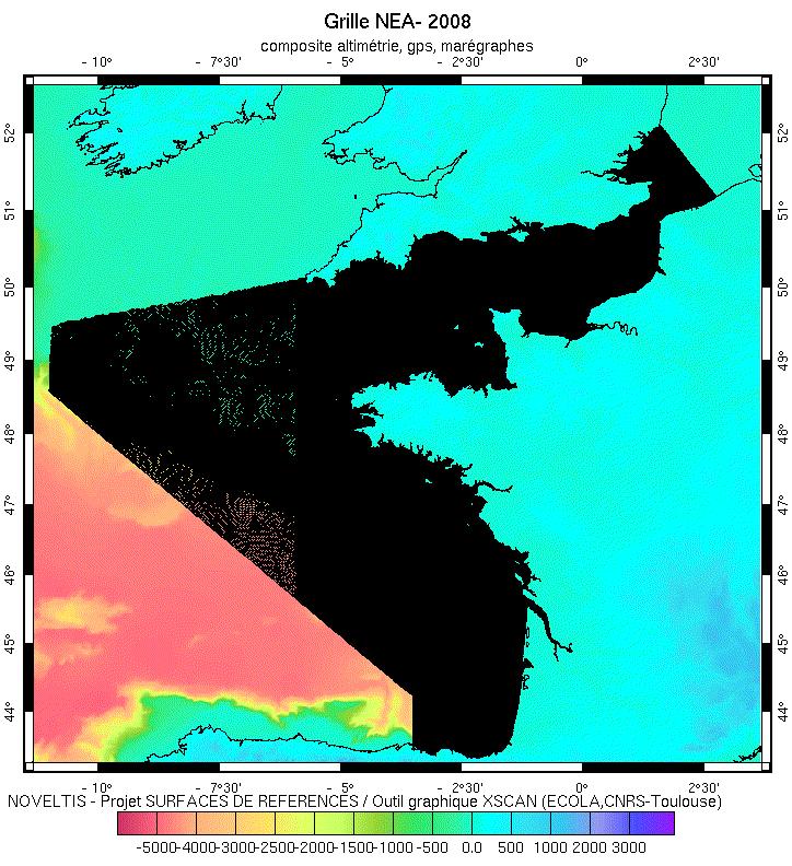
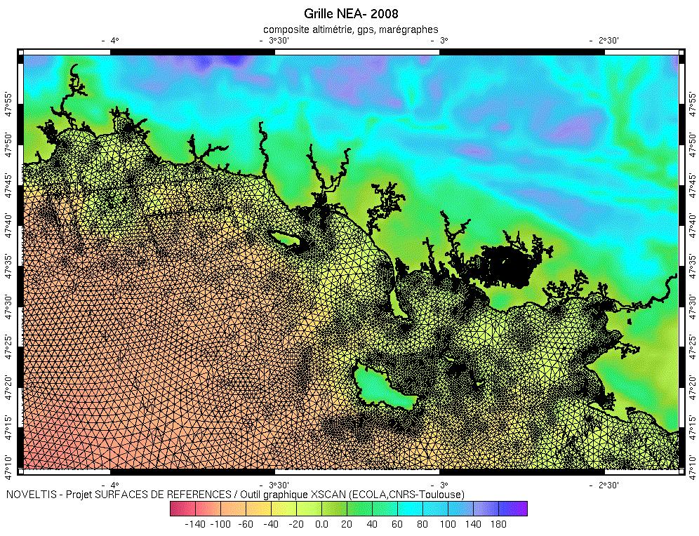
19 Grid
20 Towards a CD surface in : Interpolation of altimetry + GPS + tide gauge Estimation of the precision 2009 : reference surfaces in hydrography available CD MSL LAT ITRS ellipsoid Geoid IGN69 (french terrestrial reference system) : software allowing users to change easily from one vertical reference to another
21 Thank you for your attention
Satellite derived reference surfaces for surveying (VORF, BLAST and LAT) Dr Ole B. Andersen, DTU Space, Copenhagen, Denmark,
 Dr Ole B. Andersen, DTU Space, Copenhagen, Denmark,") Satellite derived reference surfaces for surveying (VORF, BLAST and LAT) Dr Ole B. Andersen, DTU Space, Copenhagen, Denmark, Who am I. Gravity Author of KMS02/DNSC08/DTU10 high resolution marine geophysical/geodetic
Satellite derived reference surfaces for surveying (VORF, BLAST and LAT) Dr Ole B. Andersen, DTU Space, Copenhagen, Denmark, Who am I. Gravity Author of KMS02/DNSC08/DTU10 high resolution marine geophysical/geodetic
Presented at the FIG Working Week 2017, May 29 - June 2, 2017 in Helsinki, Finland
 Presented at the FIG Working Week 2017, May 29 - June 2, 2017 in Helsinki, Finland OUTLINE I INTRODUCTION II GNSS MEASUREMENTS AND METHODOLOGY III IV TEST RESULTS AND DISCUSSION Concluding Remarks ONE
SHALLOW SOUNDING BATHYMETRIC USING MULTIBEAM ECHOSOUNDER AND TOPOGRAPHIC LASER SCANNER
 SHALLOW SOUNDING BATHYMETRIC USING MULTIBEAM ECHOSOUNDER AND TOPOGRAPHIC LASER SCANNER BY : NURSUGI, TRI PATMASARI & KHAFID GEOSPASIAL INFORMATION AGENCY AMSTERDAM, 11-14 NOVEMBER 2014 Indonesia coastline
Ground deformation monitoring at the Phlegrean Fields (Naples, Italy) from the exploitation of SAR data in the framework of CAT-1 and DUP activities
 from the exploitation of SAR data in the framework of CAT-1 and DUP activities") S. Borgström, I. Aquino, C. Del Gaudio, C. Ricco, V. Siniscalchi, G. Solaro, P. Tizzani & G.P. Ricciardi I.N.G.V. Osservatorio Vesuviano - Via Diocleziano 328, 80124 Naples, Italy INTRODUCTION CAT-1 1065
S. Borgström, I. Aquino, C. Del Gaudio, C. Ricco, V. Siniscalchi, G. Solaro, P. Tizzani & G.P. Ricciardi I.N.G.V. Osservatorio Vesuviano - Via Diocleziano 328, 80124 Naples, Italy INTRODUCTION CAT-1 1065
Victorian Coastline LiDAR Survey 2008 / 2009
 Victorian Coastline LiDAR Survey 2008 / 2009 Airborne LiDAR Bathymetric Survey for Climate Change Victorian Future Coasts Bathymetric LiDAR Survey 2008 / 2009 Mark Sinclair Dr Nathan Quadros Sydney, Australia,
Landslides Detection and Monitoring along Dieppe Coastal Cliffs Ability of boat-based Mobile Laser Scanning
 Vertical Geology Conference 2014, University of Lausanne Landslides Detection and Monitoring along Dieppe Coastal Cliffs Ability of boat-based Mobile Laser Scanning Clément Michoud 1, Dario Carrea 1, S.
Prepared for: CALIFORNIA COAST COMMISSION c/o Dr. Stephen Schroeter 45 Fremont Street, Suite 2000 San Francisco, CA
 REVIEW OF MULTIBEAM SONAR SURVEYS WHEELER REEF NORTH, SAN CLEMENTE, CALIFORNIA TO EVALUATE ACCURACY AND PRECISION OF REEF FOOTPRINT DETERMINATIONS AND CHANGES BETWEEN 2008 AND 2009 SURVEYS Prepared for:
ANALYSIS OF THE MORPHODYNAMICS OF THE GERMAN NORTH SEA COAST ON THE BASIS OF A FUNCTIONAL SEABED MODEL. Peter Milbradt1
 ANALYSIS OF THE MORPHODYNAMICS OF THE GERMAN NORTH SEA COAST ON THE BASIS OF A FUNCTIONAL SEABED MODEL Peter Milbradt1 ABSTRACT The knowledge of the hydro- and morphodynamic realities and the resulting
The Results of Limiting MRU Updates In Multibeam Data by Pat Sanders, HYPACK, Inc.
 The Results of Limiting MRU Updates In Multibeam Data by Pat Sanders, HYPACK, Inc. Abstract: Some Motion Reference Units (MRUs) can deliver heave- pitch- roll data at rates up to 100Hz. This paper investigates
Assesment, validation and further uses of LiDAR survey in the Western part of French Mediterranean sea
 BEACHMED-e/OpTIMAL Beach Erosion Monitoring Assesment, validation and further uses of LiDAR survey in the Western part of French Mediterranean sea Hugues Heurtefeux, Audrey Lesaignoux, Cléa Denamiel EID
Recent development in gravity and bathymetry mapping from satellite altimetry - The DTU10 fields. Ole B. Andersen
 Recent development in gravity and bathymetry mapping from satellite altimetry - The DTU10 fields Ole B. Andersen Outline Global Altimetric gravity from Satellite (sea surface height) Double retracking
Remote sensing In situ T, S and tracers Velocity Observing systems. Course url: Talley SIO 210 (2013)
") SIO 210: I. Observational methods and II. Data analysis (combined single lecture) Fall 2013 I. Observations Reading: DPO 6.1, S16.1, S16.4, S16.5, S16.9 Remote sensing In situ T, S and tracers Velocity
SIO 210: I. Observational methods and II. Data analysis (combined single lecture) Fall 2013 I. Observations Reading: DPO 6.1, S16.1, S16.4, S16.5, S16.9 Remote sensing In situ T, S and tracers Velocity
SEMINAR THE INTERNATIONAL HYDROGRAPHIC ORGANIZATION HYDROGRAPHIC COMMISSION ON ANTARCTICA IMPORTANCE OF HYDROGRAPHIC ACTIVITIES IN ANTARCTICA
 XXXI ATCM, Kyiv, Ukraine SEMINAR THE INTERNATIONAL HYDROGRAPHIC ORGANIZATION HYDROGRAPHIC COMMISSION ON ANTARCTICA IMPORTANCE OF HYDROGRAPHIC ACTIVITIES IN ANTARCTICA XXXI ATCM, Kyiv, Ukraine CONTENT 1st
Developments in Tide-coordinated Shoreline Mapping
 Developments in Tide-coordinated Shoreline Mapping Rongxing (Ron) Li 1 Christopher Parrish 2 Anuchit Sukcharoenpong 1 1: Mapping and GIS Laboratory, Dept. of Civil & Environmental Engineering & Geodetic
A SENSOR FUSION APPROACH TO COASTAL MAPPING
 A SENSOR FUSION APPROACH TO COASTAL MAPPING Maryellen Sault, NOAA, National Ocean Service, National Geodetic Survey Christopher Parrish, NOAA, National Ocean Service, National Geodetic Survey Stephen White,
Coastal Survey of archaeological sites using drones
 Coastal Survey of archaeological sites using drones In Poseidon s Realm XXI Underwater archaeology - interdisciplinary approaches and technical innovations Dimitrios Skarlatos, Savvidou Eleni Photogrammetric
Assessing the Potential of LiDAR/Bathymetry Integration within the Thames Estuary
 Assessing the Potential of LiDAR/Bathymetry Integration within the Thames Estuary Thomas LOWE, United Kingdom Key words: Topographic LiDAR, single beam bathymetric data, Port of London Authority, inter-tidal
Technical English -I 5 th week SURVEYING AND MAPPING
 Technical English -I 5 th week SURVEYING AND MAPPING What is surveying? It is the art of defining the positions of natural and man-made made features on the Earth s surface. Basic Tasks and Features in
MARINE SDI FOR HYDROGRAPHIC HOW HYDROGRAPHIC SURVEYS CAN BENEFIT FROM IMPLEMENTATION OF MARINE SPATIAL DATA INFRASTRUCTURES
 MARINE SDI FOR HYDROGRAPHIC HOW HYDROGRAPHIC SURVEYS CAN BENEFIT FROM IMPLEMENTATION OF MARINE SPATIAL DATA INFRASTRUCTURES MAIN IMAGE: HafenCity: Produced by the Hamburg Port Authority using CARIS BASE
Table of Contents 1 PURPOSE SCOPE DEFINITIONS PROCEDURE... 5
 Table of Contents 1 PURPOSE... 3 2 SCOPE... 3 3 DEFINITIONS... 4 4 PROCEDURE... 5 4.1 Overview - Performing a Site Calibration... 5 4.1.1 Upload Mine Grid Control... 6 4.1.2 Obtain SSM Data... 7 4.1.3
Surveying. Session GPS Surveying 1. GPS Surveying. Carrier-Phase (RTK) Pseudo-Range (DGPS) Slide 1
 Pseudo-Range (DGPS) Slide 1") GPS Surveying Slide 1 GPS Surveying Surveying Mapping Standalone Relative Relative Standalone Post-Processed Real-Time Static / Fast Static Kinematic Stop & Go Rapid-Static Carrier-Phase (RTK) Pseudo-Range
GPS Surveying Slide 1 GPS Surveying Surveying Mapping Standalone Relative Relative Standalone Post-Processed Real-Time Static / Fast Static Kinematic Stop & Go Rapid-Static Carrier-Phase (RTK) Pseudo-Range
RAILWAY PROJECT Geodetic Reference System, Geodetic Control Network and Rail Construction Measurements
 RAILWAY PROJECT Geodetic Reference System, Geodetic Control Network and Rail Construction Measurements Railway Project 2 / 8 INDEX 1 Introduction... 3 2 Reference System... 3 2.1 Reference system... 3
Ocean High Technology Institute, Inc. Tadahiko Katsura Japan Hydrographic Association
 Technical Aspects of Marine Scientific Research for Continental Shelf Outer Limits: Advanced Method of Multi-beam Data Processing to Obtain Detailed and Precise Bathymetry Yasutaka Yokoi Ocean High Technology
SEA SURFACE SPEED FROM TERRASAR-X ATI DATA
 SEA SURFACE SPEED FROM TERRASAR-X ATI DATA Matteo Soccorsi (1) and Susanne Lehner (1) (1) German Aerospace Center, Remote Sensing Technology Institute, 82234 Weßling, Germany, Email: matteo.soccorsi@dlr.de
Spring Term. Lecturer: Assoc. Prof. Dr. M. Zeki COŞKUN. Department of Geomatics Engineering
 2009 2010 Spring Term Lecturer: Assoc. Prof. Dr. M. Zeki COŞKUN Department of Geomatics Engineering e-mail : coskun@itu.edu.tr LEVELLING What is Levelling? Use of Levelling Levelling Terminology Types
Guidelines for metadata, data and DTM QA/QC
 European Marine Observation and Data Network Guidelines for metadata, data and DTM QA/QC Service Contract for Lot 1 Bathymetry Modifications Version Date Authors Comments 1.0 2009/12/03 P. Hunter, B. Loubrieu,
Geomatics Guidance Note 24 Vertical data in oil and gas applications
 REPORT 373-24 NOVEMBER 2017 Geomatics Guidance Note 24 Vertical data in oil and gas applications coordinate data Acknowledgements Geomatics Committee Geodesy Subcommittee Photography used with permission
Determination of orthometric heights from LiDAR data
 International conference on Innovative Methods in Product Design June 15 th 17 th, 2011, Venice, Italy Determination of orthometric heights from LiDAR data J. L. Pérez (a), A. T. Mozas (a), A. López (a),
Stitching Fine Resolution DEMs
 18 th World IMACS / MODSIM Congress, Cairns, Australia 13-17 July 2009 http://mssanz.org.au/modsim09 Stitching Fine Resolution DEMs Gallant, J.C. 1 and J.M. Austin 1 1 CSIRO Land and Water, Black Mountain
Teledyne PDS. Trailing Suction Hopper. Version April Teledyne RESON B.V. Stuttgartstraat AS Rotterdam The Netherlands
 Trailing Suction Hopper Teledyne PDS Version 1.1.0 April 2017 Teledyne RESON B.V. Stuttgartstraat 42-44 3047 AS Rotterdam The Netherlands Tel.: +31 (0)10 245 15 00 www.teledyne-reson.com Teledyne RESON
A NEW COMPUTER SURVEY SYSTEM
 International Hydrographic Review, Monaco, LIII (2), July 1976 A NEW COMPUTER SURVEY SYSTEM b y Takao U c h i n o Deputy Director, Surveying Division, H ydrographic Department of Japan INTRODUCTION To
Teledyne PDS. Cutter Dredge. Version March Teledyne RESON B.V. Stuttgartstraat AS Rotterdam The Netherlands
 Cutter Dredge Teledyne PDS Version 2.1.1 March 2017 Teledyne RESON B.V. Stuttgartstraat 42-44 3047 AS Rotterdam The Netherlands Tel.: +31 (0)10 245 15 00 www.teledyne-reson.com Teledyne RESON has made
The most recent CMS-Wave code developed is Version 3.2. Several new capabilities and advanced features in this version include:
 B8. Using CMS-Wave The most recent CMS-Wave code developed is Version 3.2. Several new capabilities and advanced features in this version include: Full-plane wind-generation of waves Automatic wave run-up
USER MANUAL SMC ENGLISH
 USER MANUAL SMC 2.5 - ENGLISH (USER MANUAL) CONTENTS CONTENTS (USER MANUAL) CONTENTS CONTENTS 1. INTRODUCTION...1.1 1.1 What is SMC?...1.1 1.2 What does SMC do?...1.1 1.3 SMC structure...1.2 2. SMC INSTALLATION...2.1
Delph. Seabed Mapping Software Suite FEATURES ABOUT DELPH SOFTWARE SUITE BENEFITS APPLICATIONS
 Delph Seabed Mapping Software Suite Delph Seismic, Delph Sonar and Delph Mag are complete software packages with dedicated acquisition, processing and interpretation components. They operate with any sidescan
SeaDataNet, Pan-European infrastructure for marine ands ocean data management + EMODNET Preparatory Action Hydrographic and Seabed Mapping
 SeaDataNet, Pan-European infrastructure for marine ands ocean data management + EMODNET Preparatory Action Hydrographic and Seabed Mapping By Dick M.A. Schaap Technical Coordinator SeaDataNet & Coordinator
Purpose : Understanding Projections, 12D, and the System 1200.
 Purpose : Understanding Projections, 12D, and the System 1200. 1. For any Cad work created inside 12D, the distances entered are plane (Horizontal Chord) distances. 2. Setting a projection, or changing
Mobile Laser Scanning of Intertidal Zones of Beaches using an Amphibious Vehicle
 87 Mobile Laser Scanning of Intertidal Zones of Beaches using an Amphibious Vehicle Incoul, A. 1, Nuttens, T. 1, De Maeyer, P. 1, Seube, N. 2, Stal, C. 1, Touzé, T 2 and De Wulf, A. 1, 1 Ghent University,
Perspective-MB. -- Bathymetry Processing Guide. Kongsberg.ALL Addendum
 Perspective-MB -- Bathymetry Processing Guide Kongsberg.ALL Addendum By: Tony M. Ramirez November, 2013 Triton Imaging Inc. Engineering Office 2121 41 st Avenue, Suite 211 Capitola, CA 95010 USA +1-831-722-7373
Deepwater Spoolpiece Metrology and INS
 Deepwater Spoolpiece Metrology and INS ir. Wilbert Brink AVANS Hogeschool - 16 June 2009 Introduction What is a deepwater spoolpiece metrology? What is the classical way of doing a metrology? How can we
Please refer to for specifics and limitations with these operating systems.
 Appendix B ArcReader User Guide For the Southeast Ocean Based Renewable Energy Project INTRODUCTION The purpose of this document is to provide guidance and assistance to users with ArcReader, so that they
BMGTOOLS: A COMMUNITY TOOL TO HANDLE MODEL GRID AND BATHYMETRY
 #49-April 2014-94 BMGTOOLS: A COMMUNITY TOOL TO HANDLE MODEL GRID AND BATHYMETRY By S. Theetten (1), B. Thiébault (2), F. Dumas (1), J. Paul (3) 1 2 ARTENUM, Toulouse, France 3 MERCATOR OCEAN, Toulouse,
Who we are Swathe Services offers: Equipment Sales Equipment Rental Experience Hydrographic Surveyors Turn-key survey support
 Swathe Services our results speak for themselves Who we are Swathe Services offers: Equipment Sales Equipment Rental Experience Hydrographic Surveyors Turn-key survey support Dissertation Title High Resolution
LiDAR data overview. Dr. Keiko Saito Global Facility for Disaster Reduction and Recovery (GFDRR)
") LiDAR data overview Dr. Keiko Saito Global Facility for Disaster Reduction and Recovery (GFDRR) LiDAR (Light Detecting And Ranging) 3D height profile Laser emitted from sensor onboard aircraft to measure
LiDAR data overview Dr. Keiko Saito Global Facility for Disaster Reduction and Recovery (GFDRR) LiDAR (Light Detecting And Ranging) 3D height profile Laser emitted from sensor onboard aircraft to measure
SLiP. Source Line Processing
 SLiP Source Line Processing What is SLiP SLiP (Source Line Processing) is Windows based software for computing source positions. SLiP has been specifically written for OBC type seismic surveys. It deals
Quick Start: GeoDAS-LT with Single Beam Echo Sounder
 Quick Start: GeoDAS-LT with Single Beam Echo Sounder I. Setting up GeoDAS-LT for Single Beam Echo Sounder Survey 1. Connect your single beam echo sounder, GPS receiver and other sensors (e.g. gyro and
Experience and Results from the ReDAPT and PerAWaT Projects Marine Renewables Canada Ottawa, Ontario November 21 st Technical by Nature
 Experience and Results from the ReDAPT and PerAWaT Projects Marine Renewables Canada Ottawa, Ontario November 21 st 2013 Technical by Nature Who is GL Garrad Hassan? Industry-leading, independent renewable
DECONFLICTION AND SURFACE GENERATION FROM BATHYMETRY DATA USING LR B- SPLINES
 DECONFLICTION AND SURFACE GENERATION FROM BATHYMETRY DATA USING LR B- SPLINES IQMULUS WORKSHOP BERGEN, SEPTEMBER 21, 2016 Vibeke Skytt, SINTEF Jennifer Herbert, HR Wallingford The research leading to these
HYDROFEST 2005 CAPABILITIES OF A MODERN BATHYMETRIC LIDAR SYSTEM - THE SHOALS 1000T SYSTEM. Bill Gilmour Fugro Pelagos Inc, San Diego, CA, USA
 HYDROFEST 2005 CAPABILITIES OF A MODERN BATHYMETRIC LIDAR SYSTEM - THE SHOALS 1000T SYSTEM Bill Gilmour Fugro Pelagos Inc, San Diego, CA, USA ACKNOWLEDGEMENTS FUGRO PELAGOS INC. David Millar Carol Lockhart
CARIS MSDI Use Cases. Some examples of diverse projects
 CARIS MSDI Use Cases Some examples of diverse projects INTRODUCTION SDI underpins what we do 34 years developing GIS software Specializing in Hydrography for 30+ years Also cadastral, topographic and aeronautical
Patch Test & Stability Check Report
 Patch Test & Stability Check Report Storebælt, 2009 SB Cable Project CT Offshore Final Report November, 2009 SB Cable Project November 2009 8-10 Teglbaekvej DK-8361 Hasselager Aarhus, Denmark Tel: +45
HCA13-INF6. Submitted by:
 13 th Conference of the Hydrographic Commission on Antarctica (HCA) Cadiz, Spain, 3-5 December 2013 Information Paper Establishing the DCDB as a Global Digital Bathymetry Reference Data Store (Paper submitted
Global Mean Gravity Field Models from Combination of Satellite Mission and Altimetry/Gravimetry Surface Data
 Global Mean Gravity Field Models from Combination of Satellite Mission and Altimetry/Gravimetry Surface Data Christoph Förste (1), Frank Flechtner (2), Roland Schmidt (2), Rolf König (2), Ulrich Meyer
HawkEye III - A new deep penetrating bathymetric LIDAR system
 Please insert a picture (Insert, Picture, from file). Size according to grey field (10 cm x 25.4 cm). Scale picture: highlight, pull corner point Cut picture: highlight, choose the cutting icon from the
Crowd-Sourced Bathymetry
 THE INTERNATIONAL HYDROGRAPHIC ORGANIZATION Crowd-Sourced Bathymetry NIOHC16 Chittagong, Bangladesh 14-16 March 2016 We know more about the topography of Mars and our Moon than we do about the topography
v SMS 11.1 Tutorial BOUSS2D Prerequisites Overview Tutorial Time minutes
 v. 11.1 SMS 11.1 Tutorial BOUSS2D Objectives This lesson will teach you how to use the interface for BOUSS-2D and run the model for a sample application. As a phase-resolving nonlinear wave model, BOUSS-2D
A new precise Co-geoid determined by spherical FFT for the Malaysian peninsula
 Earth Planets Space, 55, 291 299, 23 A new precise Co-geoid determined by spherical FFT for the Malaysian peninsula M. N. J. P. Vella Centre for Geodetic and Geodynamic Studies (CGGS), Faculty of Geoinformation
High-Precision Positioning Unit 2.2 Student Exercise: Calculating Topographic Change
 High-Precision Positioning Unit 2.2 Student Exercise: Calculating Topographic Change Ian Lauer and Ben Crosby (Idaho State University) Change is an inevitable part of our natural world and varies as a
Observed Differential Carrier Phase Float Accuracies on three Kinematic Surveys using a u-blox Antaris GPS Receiver under Open Sky Conditions
 Observed Differential Carrier Phase Float Accuracies on three Kinematic Surveys using a u-blox Antaris GPS Receiver under Open Sky Conditions By David MacDonald Waypoint Consulting Inc. June 2005 Three
A concept of precise kinematic positioning and flight-state monitoring from the AGMASCO practice
 LETTER Earth Planets Space, 52, 831 835, 2000 A concept of precise kinematic positioning and flight-state monitoring from the AGMASCO practice Guochang Xu GeoForschungsZentrum Potsdam (GFZ), Division Kinematics
Seabed Mapping with LiDAR
 Seabed Mapping with LiDAR 2011 Jakarta David Jonas Lt Cdr Rupert Forester-Bennett RN (ret( ret d) October 18 th 2011 Mapping in South East Asia Field Survey Aerial Photography LiDAR Pleased to Introduce
Towards a pan-european infrastructure for marine and ocean data management + Importance of standards
 Towards a pan-european infrastructure for marine and ocean data management + Importance of standards By Dick M.A. Schaap Technical Coordinator SeaDataNet & Coordinator EMODnet Bathymetry Hydrography Day,
Oceanic Observatory for the Iberian Shelf
 Oceanic Observatory for the Iberian Shelf B.Vila Barcelona, 26th September 2016 Objectives: The Project Improve the oceanic observation at the North Western Iberian coast (meteorological, oceanographical
INTERNATIONAL JOURNAL OF GEOMATICS AND GEOSCIENCES Volume 4, No 2, 2013
 INTERNATIONAL JOURNAL OF GEOMATICS AND GEOSCIENCES Volume 4, No 2, 2013 Copyright by the authors - Licensee IPA- Under Creative Commons license 3.0 Research article ISSN 0976 4380 Monitoring volume fluctuations
Interpolate Continuous Data From Non-Continuous Data. Examples. Dialog Box
 Interpolate Continuous Data From Non-Continuous Data Examples Dialog Box Interpolating Continuous Elevation Data From Contours Interpolating Continuous Bathymetric Data Using a Mask Map Layer Using the
TSMAD: Transfer Standard Maintenance & Applications Development WG Julia Powell Vice Chair
 TSMAD: Transfer Standard Maintenance & Applications Development WG Julia Powell Vice Chair ToR Objectives To maintain, develop and extend: (i) the S-57 IHO transfer standard for digital hydrographic data;
Dependency of tsunami simulations on advection scheme, grid resolution, bottom friction and topography
 IMUM-2010, MIT, 17-20 August Dependency of tsunami simulations on advection scheme, grid resolution, bottom friction and topography C. Wekerle, S. Harig, W. Pranowo, A. Androsov, A. Fuchs, N. Rakowsky,
Unstructured grid modelling
 Unstructured grid modelling Intercomparison between several finite element and finite volume approaches to model the North Sea tides Silvia Maßmann 1, Alexey Androsov 1, Sergey Danilov 1 and Jens Schröter
ACCESS 07 Phil Callahan (334), PI Brian Wilson (335), Co-I Rob Raskin (388), Co-I. October 2008
, PI Brian Wilson (335), Co-I Rob Raskin (388), Co-I. October 2008") ACCESS 07 Phil Callahan (334), PI Brian Wilson (335), Co-I Rob Raskin (388), Co-I October 2008 Advancing Collaborative Connections for Earth System Science Phil Callahan, JPL Objective Develop a web-based
ACCESS 07 Phil Callahan (334), PI Brian Wilson (335), Co-I Rob Raskin (388), Co-I October 2008 Advancing Collaborative Connections for Earth System Science Phil Callahan, JPL Objective Develop a web-based
Leica Viva Quick Guide Leica Viva: Quick Grid Guide
 Leica Viva Quick Guide Leica Viva: Quick Grid Guide Leica SmartWorx Viva has a simplified means of quickly creating a site co-ordinate system called Quick Grid. This has several methods depending on site
Healthy Estuaries 2020: Towards Addressing Coastal Squeeze in Estuaries Appendix B: Technical User Guide
 Healthy Estuaries 2020: Towards Addressing Coastal Squeeze in Estuaries Appendix B: Technical User Guide HASKONINGDHV UK LIMITED RIVERS, DELTAS & COASTS Rightwell House Bretton Peterborough PE3 8DW United
National Certificate in Surveying (Geographic Information Systems) (Level 4)
 (Level 4)") NQF Ref 0996 Version 2 Page 1 of 5 National Certificate in Surveying (Geographic Information Systems) (Level 4) Level 4 Credits 147 or 157 This qualification is expiring. The last date to meet the requirements
NQF Ref 0996 Version 2 Page 1 of 5 National Certificate in Surveying (Geographic Information Systems) (Level 4) Level 4 Credits 147 or 157 This qualification is expiring. The last date to meet the requirements
Overview of the SMS (v11.0)
") Overview of the SMS (v11.0) Mitchell Brown Civil Engineering Technician Mitchell.E.Brown@erdc.dren.mil June 11-15, 2012 CMS Shark River Inlet, NJ CPT Grays Harbor, WA Wood Wood chips Flour Other US Army
Overview of the SMS (v11.0) Mitchell Brown Civil Engineering Technician Mitchell.E.Brown@erdc.dren.mil June 11-15, 2012 CMS Shark River Inlet, NJ CPT Grays Harbor, WA Wood Wood chips Flour Other US Army
Inertial Systems. Ekinox Series TACTICAL GRADE MEMS. Motion Sensing & Navigation IMU AHRS MRU INS VG
 Ekinox Series TACTICAL GRADE MEMS Inertial Systems IMU AHRS MRU INS VG ITAR Free 0.05 RMS Motion Sensing & Navigation AEROSPACE GROUND MARINE Ekinox Series R&D specialists usually compromise between high
BATHYMETRIC EXTRACTION USING WORLDVIEW-2 HIGH RESOLUTION IMAGES
 BATHYMETRIC EXTRACTION USING WORLDVIEW-2 HIGH RESOLUTION IMAGES M. Deidda a, G. Sanna a a DICAAR, Dept. of Civil and Environmental Engineering and Architecture. University of Cagliari, 09123 Cagliari,
Chapter 18: Basic Ribbit
 Chapter 18: Basic Ribbit Introduction Ribbit is a data processing program written by Fugro Pelagos to provide data processing capabilities primarily for WinFrog data. This software makes the processing
The Global Positioning Sytem II 10/13/ /13/2015 GEO327G/386G, UT Austin /13/2015 GEO327G/386G, UT Austin 5-4
 The Global Positioning System II Field Experiments Mexico DGPS Field Campaign Cenotes in Tamaulipas, MX, near Aldama 10/13/2015 GEO327G/386G, UT Austin 5-1 10/13/2015 GEO327G/386G, UT Austin 5-2 Are Cenote
TSCOM report to GC Preliminary report June 2014 International Hydrographic Bureau, Monaco
 TSCOM report to GC 2014 Preliminary report 13-15 June 2014 International Hydrographic Bureau, Monaco TSCOM Updates TSCOM membership GEBCO Data Store IHO-IOC GEBCO Cook Book GEBCO Hi-Res product Joint TSCOM/SCRUM
Maintaining Accurate Coordinates after a Geodetic Datum Update
 FIG Working Week 2009, Eilat, Israel Maintaining Accurate Coordinates after a Geodetic Datum Update NIC DONNELLY Geodetic Surveyor 6 May 2009 Introduction Geodetic datum updates Geospatial dataset updates:
Canadian Hydrographic Service Hydrographic Information Network
 Stephen FORBES, Robert BURKE and Gerard COSTELLO, Canada Key words: ABSTRACT The Canadian Hydrographic Service (CHS) commenced the Hydrographic Information Network (HIN) initiative during the early 1990's.
Bottom friction estimation in the context of regional barotropic tide modelling
 Bottom friction estimation in the context of regional barotropic tide modelling Martial Boutet1, Cyril Lathuilière1, Rémy Baraille2, Hong Son Hoang2, Yves Morel3 1 SHOM, Brest, France; 2SHOM, Toulouse,
Feature Detection Performance of a Bathymetric Lidar in Saipan
 Feature Detection Performance of a Bathymetric Lidar in Saipan LTJG Russell Quintero NOAA National Geodetic Survey - JALBTCX, Kiln, MS russell.quintero@noaa.gov Jerry Mills NOAA Office of Coast Survey
THE USE OF TERRESTRIAL LASER SCANNING FOR MEASUREMENTS IN SHALLOW-WATER: CORRECTION OF THE 3D COORDINATES OF THE POINT CLOUD
 Photogrammetry and Remote Sensing Published as: Deruyter, G., Vanhaelst, M., Stal, C., Glas, H., De Wulf, A. (2015). The use of terrestrial laser scanning for measurements in shallow-water: correction
Appendix B. Figure 1. Canal System and Baseline Development
 Survey Tide Correction Program Conceptual Description Appendix B The Survey Tide Correction program developed in the University of Florida Coastal and Oceanographic Engineering Department by Bill Miller
Hindcasting Coastal Sea Levels in Morecambe Bay
 Estuarine, Coastal and Shelf Science (2001) 53, 459 466 doi:10.1006/ecss.1999.0626, available online at http://www.idealibrary.com on Hindcasting Coastal Sea Levels in Morecambe Bay J. D. Annan Proudman
Base Configurations Carlson SurvCE
 There are six methods to set the stationary base position, organized into 2 categories: From New Position includes Read from GPS, Enter Lat/Long and Enter Grid System Coordinates. The From Known Position
POSITION PAPER. QUALITY CONTROL Prepared: TenneT team Reviewed: M. Müller Approved: F. Wester Release.
 POSITION PAPER STAKE HOLDER CONSULTATION PROCESS OFFSHORE GRID NL Type: Position paper Work stream Technical Topic: T.18 Data acquisition systems on offshore platform Filename ONL-TTB-03103 T18_Data acquisition
Seminario del DCAIN. Offshore Measurements of Ocean Waves using Stereo Vision Systems
 Seminario del DCAIN Offshore Measurements of Ocean Waves using Stereo Vision Systems Guillermo Gallego Grupo de Tratamiento de Imágenes Universidad Politécnica de Madrid, Spain. Trabajo en colaboración
Validating the digital terrain model.doc
 Title: Validating the digital terrain model Author(s): Jacques Populus (Ifremer) Document owner: Jacques Populus (jpopulus@ifremer.fr) Reviewed by: Roger Coggan (Cefas) Workgroup: MESH action: Action 2.2
TechnicalNotes. Trimble Total Control Software
 TechnicalNotes Trimble Total Control Software POWERFUL GEODETIC CONTROL FOR ALL SURVEY PROJECTS A survey is only as good as its control elements. Trimble Total Control software puts you in total control
Estimating Along-Channel Flow and Sediment Transport at Tidal Entrances EbbJet Calculator
 Estimating Along-Channel Flow and Sediment Transport at Tidal Entrances EbbJet Calculator by Mark S. Gosselin and Kenneth R. Craig PURPOSE: The Coastal Engineering Technical Note (CHETN) herein describes
Neural networks for the generation of sea bed models using airborne lidar bathymetry data
 GEODESY AND CARTOGRAPHY Vol. 65, No 1, 2016, pp. 41-53 Polish Academy of Sciences DOI: 10.1515/geocart-2016-0007 Neural networks for the generation of sea bed models using airborne lidar bathymetry data
CONSISTENT AND INCONSISTENT TRANSFORMATIONS
 UZODINMA, Victus N. and EHIGIATOR-IRUGHE, Raphael Nigeria CONSISTENT AND INCONSISTENT TRANSFORMATIONS 1 In the Nigerian Petroleum industry very many transformation sets are applied by different Companies
v SMS Tutorials ADCIRC LTEA Time minutes Prerequisites ADCIRC Tutorial Overview Tutorial
 v. 11.2 SMS 11.2 Tutorial Objectives LTEA stands for the Local Truncation Error Analysis. The name refers to an analysis methodology for measuring local truncation error in a numerical analysis. The LTEA
Updating Autonomous Start to an RTK Field Survey (Part II)
") Updating Autonomous Start to an RTK Field Survey (Part II) Oscar R. Cantu Topcon University FTP Site For access to previously offered webinars and supporting documentation, please go to: ftp://tulive+topconuniversity.com:tulive@ftp.topconuniversity.com
Updating Autonomous Start to an RTK Field Survey (Part II) Oscar R. Cantu Topcon University FTP Site For access to previously offered webinars and supporting documentation, please go to: ftp://tulive+topconuniversity.com:tulive@ftp.topconuniversity.com
Assessment of digital elevation models using RTK GPS
 Assessment of digital elevation models using RTK GPS Hsing-Chung Chang 1, Linlin Ge 2, Chris Rizos 3 School of Surveying and Spatial Information Systems University of New South Wales, Sydney, Australia
High quality triangular grid generation for the risk analysis of a special lagoon
 Advances in Fluid Mechanics VIII 31 High quality triangular grid generation for the risk analysis of a special lagoon B. Tansel Istanbul Technical University, Maritime Faculty, Turkey Abstract Much of
MIKE 21 Flow Model FM. Parallelisation using GPU. Verification report
 MIKE 21 Flow Model FM Parallelisation using GPU Verification report MIKE by DHI 2014 DHI headquarters Agern Allé 5 DK-2970 Hørsholm Denmark +45 4516 9200 Telephone +45 4516 9333 Support +45 4516 9292 Telefax
Eunmi Chang, Hyo-Hyun Sung, Jaeyeong Roh, Eunyoung Kim
 Eunmi Chang, Hyo-Hyun Sung, Jaeyeong Roh, Eunyoung Kim Ziinconsulting INC., Ewha Woman s University Korean Hydrographic and Oceanographic Administration Geostrory INC. Based on (IMO Res. A 884(21)) Marine
National GNSS/BDS CORS Services in China
 National GNSS/BDS CORS Services in China Prof. Yamin Dang Chinese Academy of Surveying & Mapping E-mail:dangym@casm.ac.cn Outline 1 2 3 Reference Frame in China: CGCS 2000 GNSS/BDS CORS Service System